Bridge Statistics for St. Albans, West Virginia (WV)
Condition, Traffic, Stress, Structural Evaluation, Project Costs
- National Bridge Inventory (NBI) Statistics
- 13Number of bridges
- 328ft / 99.5mTotal length
- $950,000Total costs
- 152,100Total average daily traffic
- 10,775Total average daily truck traffic
- National Bridge Inventory (NBI) Registered Bridges for St. Albans
- No street view available for this location
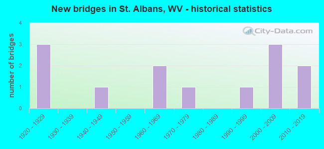
- New bridges - historical statistics
- 31920-1929
- 11940-1949
- 21960-1969
- 11970-1979
- 11990-1999
- 32000-2009
- 22010-2019


- Bridge Condition - Deck
- 50.0%Good
- 12.5%Satisfactory
- 37.5%Fair

- Bridge Condition - Superstructure
- 25.0%Very good
- 37.5%Good
- 25.0%Satisfactory
- 12.5%Fair

- Bridge Condition - Substructure
- 25.0%Very good
- 37.5%Good
- 25.0%Satisfactory
- 12.5%Fair

- Bridge Condition - Channel
- 83.3%Very good
- 16.7%Satisfactory
Find on map >> Show street view
Structure Number: 20A171, Location: 0.08 MI E OF CR 60/2 SLS (Lat: 38.386119, Lng: -81.840419), Route carried "on" structure: County highway 6014, Year Built: 1965, Status: Open, Structure Length: 9.13m (29.95ft), Average Daily Traffic: 8,100 (year 2018), Truck Traffic: 5%, Average Future Daily Traffic: 9,882 (year 2038), Design Load: HS 20, Features Intersected: COAL RIVER, Facility Carried by Structure: CR 60/14
Minimum Vertical Clearance: 30+ m (98+ ft), Kilometerpoint: 5.858, Lanes on structure: 2, Owner: State Highway Agency, Approaching Roadway Width: 7.3m (24.0ft), Material/Design: Steel continuous, Design/Construction: Stringer/Multi-beam, Number Of Spans In Main Unit: 1, Number Of Approach Spans: 2, Length of Maximum Span: 35.1m (115.2ft), Curb or Sidewalk Widths: Left: 1.5m (4.9ft), Right: 1.5m (4.9ft), Curb-To-Curb Width: 11.0m (36.1ft), Out-to-Out Width: 11.6m (38.1ft)
Condition: Deck: Fair, Superstructure: Satisfactory, Substructure: Satisfactory, Channel: Very good, Operating Rating: 59.9 metric tons, Method Used To Determine Operating Rating: Load Factor (LF), Inventory Rating: 35.4 metric tons, Method Used To Determine Inventory Rating: Load Factor (LF), Structural Evaluation: Equal to present minimum criteria, Deck Geometry: Meets minimum limits, Waterway Adequacy: Equal to present desirable criteria, Approach Roadway Alignment: Equal to present minimum criteria, Length Of Structure Improvement: 9.13m (29.95ft), Designated Inspection Frequency: Every 24 months, Underwater Inspection Frequency: Every 60 months, Inspection Date: May 2020, Underwater Inspection Date: August 2021, Bridge Improvement Cost: $300,000, Roadway Improvement Cost: $50,000, Total Project Cost: $350,000 ( Estimate for 2020), Deck Structure Type: Concrete Cast-file-Place, Wearing Surface/Protective System: Wearing Surface: Latex Concrete, Membrane: Built-up
Find on map >> Show street view
Structure Number: 20A322, Location: 0.05 MI N OF CR 35/9 (Lat: 38.414511, Lng: -81.858800), Route carried "on" structure: State highway 817, Year Built: 1976, Status: Open, Structure Length: 9.97m (32.71ft), Average Daily Traffic: 13,900 (year 2018), Truck Traffic: 6%, Average Future Daily Traffic: 16,958 (year 2038), Design Load: HS 20, Features Intersected: CSX RAILROAD
Minimum Vertical Clearance: 30+ m (98+ ft), Kilometerpoint: 1.979, Lanes on structure: 2, Base Highway Network: Yes, Owner: State Highway Agency, Approaching Roadway Width: 14.6m (47.9ft), Skew: 5 degrees, Material/Design: Steel continuous, Design/Construction: Stringer/Multi-beam, Number Of Spans In Main Unit: 1, Number Of Approach Spans: 2, Length of Maximum Span: 36.6m (120.1ft), Curb-To-Curb Width: 14.2m (46.6ft), Out-to-Out Width: 15.5m (50.9ft)
Condition: Deck: Satisfactory, Superstructure: Satisfactory, Substructure: Satisfactory, Operating Rating: 59.9 metric tons, Method Used To Determine Operating Rating: Load Factor (LF), Inventory Rating: 35.4 metric tons, Method Used To Determine Inventory Rating: Load Factor (LF), Structural Evaluation: Equal to present minimum criteria, Deck Geometry: Superior to present desirable criteria, Underclear: Equal to present minimum criteria, Approach Roadway Alignment: Equal to present desirable criteria, Length Of Structure Improvement: 9.97m (32.71ft), Designated Inspection Frequency: Every 24 months, Inspection Date: August 2020, Bridge Improvement Cost: $500,000, Roadway Improvement Cost: $100,000, Total Project Cost: $600,000 ( Estimate for 2020), Deck Structure Type: Concrete Cast-file-Place, Wearing Surface/Protective System: Wearing Surface: Latex Concrete
Find on map >> Show street view
Structure Number: 20A677, Location: 0.01 MI S OF CR 17/1 (Lat: 38.398511, Lng: -81.855711), Route carried "on" structure: State highway 817, Year Built: 1992, Status: Open, Structure Length: 1.41m (4.63ft), Average Daily Traffic: 19,200 (year 2018), Truck Traffic: 6%, Average Future Daily Traffic: 23,424 (year 2038), Design Load: HS 25 or greater, Features Intersected: TACKETT CREEK
Minimum Vertical Clearance: 30+ m (98+ ft), Kilometerpoint: 0.451, Lanes on structure: 3, Base Highway Network: Yes, Owner: State Highway Agency, Approaching Roadway Width: 11.6m (38.1ft), Material/Design: Prestressed concrete, Design/Construction: Box Beam or Girders - Multiple, Number Of Spans In Main Unit: 1, Length of Maximum Span: 12.2m (40.0ft), Curb or Sidewalk Widths: Left: 1.7m (5.6ft), Right: 0.0m, Curb-To-Curb Width: 12.3m (40.4ft), Out-to-Out Width: 14.8m (48.6ft)
Condition: Deck: Fair, Superstructure: Fair, Substructure: Fair, Channel: Very good, Operating Rating: 88.9 metric tons, Method Used To Determine Operating Rating: Load Factor (LF), Inventory Rating: 58.0 metric tons, Method Used To Determine Inventory Rating: Load Factor (LF), Structural Evaluation: Somewhat better than minimum adequacy, Deck Geometry: Meets minimum limits, Waterway Adequacy: Equal to present minimum criteria, Approach Roadway Alignment: Equal to present desirable criteria, Designated Inspection Frequency: Every 24 months, Inspection Date: March 2020, Deck Structure Type: Other, Wearing Surface/Protective System: Wearing Surface: Bituminous, Deck Protection: Epoxy Coated Reinforcing
Find on map >> Show street view
Structure Number: 20A688, Location: 2.35 MI E OF WV 25 SPUR (Lat: 38.379931, Lng: -81.791731), Route carried "on" structure: US 60, Year Built: 1940, Status: Open, Structure Length: 0.63m (2.07ft), Average Daily Traffic: 20,900 (year 2018), Truck Traffic: 6%, Average Future Daily Traffic: 25,498 (year 2038), Features Intersected: MILE CREEK
Minimum Vertical Clearance: 30+ m (98+ ft), Kilometerpoint: 9.930, Lanes on structure: 5, Base Highway Network: Yes, Owner: State Highway Agency, Approaching Roadway Width: 19.8m (65.0ft), Material/Design: Concrete continuous, Design/Construction: Culvert, Number Of Spans In Main Unit: 2, Length of Maximum Span: 3.0m (9.8ft)
Condition: Channel: Satisfactory, Culverts: Fair, Operating Rating: 63.5 metric tons, Method Used To Determine Operating Rating: Field evaluation and documented engineering judgment, Inventory Rating: 29.0 metric tons, Method Used To Determine Inventory Rating: Field evaluation and documented engineering judgment, Structural Evaluation: Somewhat better than minimum adequacy, Waterway Adequacy: Equal to present minimum criteria, Approach Roadway Alignment: Equal to present desirable criteria, Designated Inspection Frequency: Every 24 months, Inspection Date: July 2020
Find on map >> Show street view
Structure Number: 20A809, Location: 0.11 MILE E OF CR 171 (Lat: 38.392100, Lng: -81.840931), Route carried "on" structure: US 60, Year Built: 2005, Status: Open, Structure Length: 19.29m (63.29ft), Average Daily Traffic: 15,000 (year 2020), Truck Traffic: 5%, Average Future Daily Traffic: 15,750 (year 2040), Design Load: HL 93, Features Intersected: COAL RIVER
Minimum Vertical Clearance: 30+ m (98+ ft), Kilometerpoint: 5.343, Lanes on structure: 4, Base Highway Network: Yes, Owner: State Highway Agency, Approaching Roadway Width: 18.3m (60.0ft), Skew: 10 degrees, Material/Design: Steel continuous, Design/Construction: Stringer/Multi-beam, Number Of Spans In Main Unit: 1, Number Of Approach Spans: 2, Length of Maximum Span: 73.2m (240.2ft), Curb or Sidewalk Widths: Left: 1.5m (4.9ft), Right: 1.5m (4.9ft), Curb-To-Curb Width: 19.5m (64.0ft), Out-to-Out Width: 24.0m (78.7ft)
Condition: Deck: Fair, Superstructure: Good, Substructure: Good, Channel: Very good, Operating Rating: 41.7 metric tons, Method Used To Determine Operating Rating: Load and Resistance Factor (LRFR), Inventory Rating: 32.7 metric tons, Method Used To Determine Inventory Rating: Load and Resistance Factor (LRFR), Structural Evaluation: Better than present minimum criteria, Deck Geometry: Better than present minimum criteria, Waterway Adequacy: Superior to present desirable criteria, Approach Roadway Alignment: Equal to present desirable criteria, Designated Inspection Frequency: Every 24 months, Underwater Inspection Frequency: Every 60 months, Inspection Date: November 2021, Underwater Inspection Date: August 2021, Deck Structure Type: Concrete Cast-file-Place, Wearing Surface/Protective System: Wearing Surface: Monolithic Concrete, Deck Protection: Epoxy Coated Reinforcing
Find on map >> Show street view
Structure Number: 20A82, Location: 0.42 MI E OF WV 817 (Lat: 38.396231, Lng: -81.848239), Route carried "on" structure: US 60, Year Built: 2005, Status: Open, Structure Length: 11.49m (37.70ft), Average Daily Traffic: 8,450 (year 2018), Truck Traffic: 6%, Average Future Daily Traffic: 10,309 (year 2038), Design Load: HL 93, Features Intersected: CSX RAILROAD
Minimum Vertical Clearance: 30+ m (98+ ft), Kilometerpoint: 4.603, Lanes on structure: 2, Base Highway Network: Yes, Owner: State Highway Agency, Approaching Roadway Width: 18.3m (60.0ft), Skew: 10 degrees, Material/Design: Steel continuous, Design/Construction: Stringer/Multi-beam, Number Of Spans In Main Unit: 1, Number Of Approach Spans: 2, Length of Maximum Span: 47.9m (157.2ft), Curb or Sidewalk Widths: Left: 1.5m (4.9ft), Right: 1.5m (4.9ft), Curb-To-Curb Width: 9.1m (29.9ft), Out-to-Out Width: 11.9m (39.0ft)
Condition: Deck: Good, Superstructure: Good, Substructure: Good, Operating Rating: 42.6 metric tons, Method Used To Determine Operating Rating: Load and Resistance Factor (LRFR), Inventory Rating: 33.6 metric tons, Method Used To Determine Inventory Rating: Load and Resistance Factor (LRFR), Structural Evaluation: Better than present minimum criteria, Deck Geometry: Meets minimum limits, Underclear: Equal to present desirable criteria, Approach Roadway Alignment: Equal to present desirable criteria, Designated Inspection Frequency: Every 24 months, Inspection Date: April 2020, Deck Structure Type: Concrete Cast-file-Place, Wearing Surface/Protective System: Wearing Surface: Monolithic Concrete, Deck Protection: Epoxy Coated Reinforcing
Find on map >> Show street view
Structure Number: 20A821, Location: 0.42 MI E OF WV 817 (Lat: 38.396281, Lng: -81.848231), Route carried "on" structure: US 60, Year Built: 2005, Status: Open, Structure Length: 11.55m (37.89ft), Average Daily Traffic: 8,450 (year 2018), Truck Traffic: 6%, Average Future Daily Traffic: 10,309 (year 2038), Design Load: HL 93, Features Intersected: CSX RAILROAD
Minimum Vertical Clearance: 30+ m (98+ ft), Kilometerpoint: 4.603, Lanes on structure: 2, Base Highway Network: Yes, Owner: State Highway Agency, Approaching Roadway Width: 18.3m (60.0ft), Material/Design: Steel continuous, Design/Construction: Stringer/Multi-beam, Number Of Spans In Main Unit: 1, Number Of Approach Spans: 2, Length of Maximum Span: 47.3m (155.2ft), Curb or Sidewalk Widths: Left: 1.5m (4.9ft), Right: 0.6m (2.0ft), Curb-To-Curb Width: 9.1m (29.9ft), Out-to-Out Width: 11.9m (39.0ft)
Condition: Deck: Good, Superstructure: Good, Substructure: Good, Operating Rating: 42.6 metric tons, Method Used To Determine Operating Rating: Load and Resistance Factor (LRFR), Inventory Rating: 33.6 metric tons, Method Used To Determine Inventory Rating: Load and Resistance Factor (LRFR), Structural Evaluation: Better than present minimum criteria, Deck Geometry: Meets minimum limits, Underclear: Equal to present desirable criteria, Approach Roadway Alignment: Equal to present desirable criteria, Designated Inspection Frequency: Every 24 months, Inspection Date: April 2020, Deck Structure Type: Concrete Cast-file-Place, Wearing Surface/Protective System: Wearing Surface: Monolithic Concrete, Deck Protection: Epoxy Coated Reinforcing
Find on map >> Show street view
Structure Number: 20A857, Location: 0.05 MILES NORTH OF WV 60 (Lat: 38.391789, Lng: -81.831950), Route carried "on" structure: Spur State highway 25, Year Built: 2013, Status: Open, Structure Length: 31.06m (101.90ft), Average Daily Traffic: 13,400 (year 2018), Truck Traffic: 6%, Average Future Daily Traffic: 16,348 (year 2038), Design Load: HL 93, Features Intersected: KANAWHA RIVER
Minimum Vertical Clearance: 30+ m (98+ ft), Kilometerpoint: 0.080, Lanes on structure: 3, Base Highway Network: Yes, Owner: State Highway Agency, Approaching Roadway Width: 14.6m (47.9ft), Navigation Control: Yes ( Vertical Clearance: 18.3m (60.0ft), Horizontal Clearance: 132.9m (436.0ft)), Material/Design: Steel continuous, Design/Construction: Stringer/Multi-beam, Number Of Spans In Main Unit: 1, Number Of Approach Spans: 2, Length of Maximum Span: 137.2m (450.1ft), Curb or Sidewalk Widths: Left: 1.5m (4.9ft), Right: 0.0m, Curb-To-Curb Width: 14.6m (47.9ft), Out-to-Out Width: 16.8m (55.1ft)
Condition: Deck: Good, Superstructure: Very good, Substructure: Very good, Channel: Very good, Operating Rating: 41.7 metric tons, Method Used To Determine Operating Rating: Load and Resistance Factor (LRFR), Inventory Rating: 31.7 metric tons, Method Used To Determine Inventory Rating: Load and Resistance Factor (LRFR), Structural Evaluation: Better than present minimum criteria, Deck Geometry: Somewhat better than minimum adequacy, Waterway Adequacy: Superior to present desirable criteria, Approach Roadway Alignment: Superior to present desirable criteria, Designated Inspection Frequency: Every 24 months, Underwater Inspection Frequency: Every 60 months, Inspection Date: April 2020, Underwater Inspection Date: September 2020, Deck Structure Type: Concrete Cast-file-Place, Wearing Surface/Protective System: Wearing Surface: Monolithic Concrete, Deck Protection: Epoxy Coated Reinforcing
Find on map >> Show street view
Structure Number: 40A163, Location: 0.08 Mile N of CR 17/4 (Lat: 38.433450, Lng: -81.853311), Route carried "on" structure: State highway 817, Year Built: 2011, Status: Open, Structure Length: 4.97m (16.31ft), Average Daily Traffic: 13,100 (year 2020), Truck Traffic: 6%, Average Future Daily Traffic: 16,113 (year 2040), Design Load: HL 93, Features Intersected: SCARY CREEK
Minimum Vertical Clearance: 30+ m (98+ ft), Kilometerpoint: 1.706, Lanes on structure: 2, Base Highway Network: Yes, Owner: State Highway Agency, Approaching Roadway Width: 12.2m (40.0ft), Material/Design: Steel, Design/Construction: Stringer/Multi-beam, Number Of Spans In Main Unit: 1, Length of Maximum Span: 48.8m (160.1ft), Curb-To-Curb Width: 12.2m (40.0ft), Out-to-Out Width: 13.0m (42.7ft)
Condition: Deck: Good, Superstructure: Very good, Substructure: Very good, Channel: Very good, Operating Rating: 42.6 metric tons, Method Used To Determine Operating Rating: Load and Resistance Factor (LRFR), Inventory Rating: 32.7 metric tons, Method Used To Determine Inventory Rating: Load and Resistance Factor (LRFR), Structural Evaluation: Equal to present desirable criteria, Deck Geometry: Somewhat better than minimum adequacy, Waterway Adequacy: Equal to present desirable criteria, Approach Roadway Alignment: Equal to present desirable criteria, Designated Inspection Frequency: Every 24 months, Inspection Date: October 2021, Deck Structure Type: Concrete Cast-file-Place, Wearing Surface/Protective System: Wearing Surface: Integral Concrete, Deck Protection: Epoxy Coated Reinforcing
Find on map >> Show street view
Structure Number: 20A298, Location: 0.11 MI S OF US 60 (Lat: 38.388311, Lng: -81.834169), Route carried "under" structure: County highway 606, Year Built: 1929, Structure Length: 0. m, Average Daily Traffic: 6,600 (year 2019), Truck Traffic: 5%, Features Intersected: COUNTY ROUTE 6/6, Facility Carried by Structure: CSX RR OWN #4657
Minimum Vertical Clearance: 3.58m (11.75ft), Kilometerpoint: 9.801, Lanes under structure: 2, Material/Design: Steel, Design/Construction: Stringer/Multi-beam, Length of Maximum Span: 8.2m (26.9ft)
Find on map >> Show street view
Structure Number: 20A356, Location: 0.04 MI W OF US 60 (Lat: 38.374631, Lng: -81.780611), Route carried "under" structure: County highway 6014, Year Built: 1921, Structure Length: 0. m, Average Daily Traffic: 6,700 (year 2018), Truck Traffic: 5%, Features Intersected: COUNTY ROUTE 60/14, Facility Carried by Structure: CSX RR OWNER #4626
Minimum Vertical Clearance: 4.12m (13.52ft), Kilometerpoint: 0.064, Lanes under structure: 2, Material/Design: Steel, Design/Construction: Stringer/Multi-beam, Length of Maximum Span: 14.0m (45.9ft)
Find on map >> Show street view
Structure Number: 20A92, Location: 0.70 MI E OF CR 6/6 (Lat: 38.382511, Lng: -81.822331), Route carried "under" structure: City street N1420, Year Built: 1921, Structure Length: 0. m, Features Intersected: WASHINGTON AVENUE, Facility Carried by Structure: CSX RR OWNER #0.20
Minimum Vertical Clearance: 4.01m (13.16ft), Kilometerpoint: 0.016, Lanes under structure: 2, Length of Maximum Span: 6.0m (19.7ft)
Find on map >> Show street view
Structure Number: 40A077, Location: 0.06 MI W OF WV 817 (Lat: 38.441100, Lng: -81.850311), Route carried "under" structure: Ramp Interstate 6400, Year Built: 1961, Structure Length: 0. m, Average Daily Traffic: 18,300 (year 2013), Truck Traffic: 17%, Features Intersected: I-64 ST ALBANS RAMP, Facility Carried by Structure: CSX/AEP OWN#CLG1.0
Minimum Vertical Clearance: 7.52m (24.67ft), Kilometerpoint: 70.441, Lanes under structure: 3, Material/Design: Steel, Design/Construction: Stringer/Multi-beam, Length of Maximum Span: 23.2m (76.1ft)