Bridge Statistics for Springfield, New Jersey (NJ)
Condition, Traffic, Stress, Structural Evaluation, Project Costs
- National Bridge Inventory (NBI) Statistics
- 47Number of bridges
- 381ft / 116mTotal length
- $35,265,000Total costs
- 1,725,357Total average daily traffic
- 129,520Total average daily truck traffic
- National Bridge Inventory (NBI) Registered Bridges for Springfield
- No street view available for this location
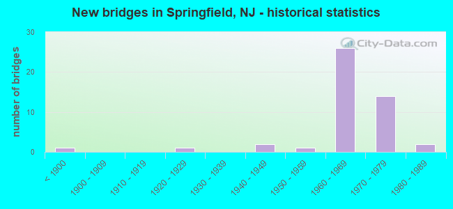
- New bridges - historical statistics
- 1Before 1900
- 11920-1929
- 21940-1949
- 11950-1959
- 261960-1969
- 141970-1979
- 21980-1989

- Reconstructed bridges - Historical Statistics
- 11930-1939
- 01940-1949
- 01950-1959
- 11960-1969
- 01970-1979
- 11980-1989
- 01990-1999
- 02000-2009
- 12010-2019


- Bridge Condition - Deck
- 4.8%Excellent
- 19.0%Good
- 42.9%Satisfactory
- 23.8%Fair
- 9.5%Poor

- Bridge Condition - Superstructure
- 4.5%Excellent
- 18.2%Good
- 45.5%Satisfactory
- 13.6%Fair
- 13.6%Poor
- 4.5%Serious

- Bridge Condition - Substructure
- 13.6%Good
- 54.5%Satisfactory
- 27.3%Fair
- 4.5%Poor

- Bridge Condition - Channel
- 40.0%Good
- 30.0%Satisfactory
- 20.0%Fair
- 10.0%Poor

- Bridge Condition - Culverts
- 25.0%Good
- 25.0%Satisfactory
- 50.0%Fair
Find on map >> Show street view
Structure Number: 200316, Location: 3.3 MI WEST OF PARKWAY (Lat: 40.684800, Lng: -74.328531), Route carried "on" structure: Spur County highway 509, Year Built: 1940, Status: Open, Structure Length: 3.87m (12.70ft), Average Daily Traffic: 10,785 (year 2021), Truck Traffic: 4%, Average Future Daily Traffic: 12,942 (year 2041), Design Load: HS 20, Features Intersected: US 22
Minimum Vertical Clearance: 30+ m (98+ ft), Kilometerpoint: 1.497, Lanes on structure: 2, Lanes under structure: 4, Owner: State Highway Agency, Approaching Roadway Width: 12.8m (42.0ft), Skew: 24 degrees, Material/Design: Steel, Design/Construction: Stringer/Multi-beam, Number Of Spans In Main Unit: 2, Length of Maximum Span: 18.6m (61.0ft), Curb or Sidewalk Widths: Left: 1.9m (6.2ft), Right: 1.8m (5.9ft), Curb-To-Curb Width: 12.8m (42.0ft), Out-to-Out Width: 17.3m (56.8ft)
Condition: Deck: Fair, Superstructure: Poor, Substructure: Poor, Operating Rating: 52.6 metric tons, Method Used To Determine Operating Rating: Load Factor (LF), Inventory Rating: 31.8 metric tons, Method Used To Determine Inventory Rating: Load Factor (LF), Structural Evaluation: Meets minimum limits, Deck Geometry: Somewhat better than minimum adequacy, Underclear: High priority of replacement, Approach Roadway Alignment: Equal to present desirable criteria, Length Of Structure Improvement: 4.82m (15.81ft), Designated Inspection Frequency: Every 24 months, Inspection Date: July 2021, Bridge Improvement Cost: $3,513,000, Roadway Improvement Cost: $527,000, Total Project Cost: $6,500,000 ( Estimate for 2021), Deck Structure Type: Concrete Cast-file-Place, Wearing Surface/Protective System: Wearing Surface: Bituminous
Find on map >> Show street view
Structure Number: 200515, Location: 0.21 MILE WEST OF I-78 (Lat: 40.712000, Lng: -74.299619), Route carried "on" structure: State highway 124, Year Built: 1967, Status: Open, Structure Length: 3.78m (12.40ft), Average Daily Traffic: 28,338 (year 2020), Truck Traffic: 4%, Average Future Daily Traffic: 34,578 (year 2040), Design Load: HS 20, Features Intersected: RAHWAY RIVER
Minimum Vertical Clearance: 30+ m (98+ ft), Kilometerpoint: 19.183, Lanes on structure: 4, Base Highway Network: Yes, Owner: State Highway Agency, Approaching Roadway Width: 15.8m (51.8ft), Skew: 23 degrees, Material/Design: Concrete, Design/Construction: Culvert, Number Of Spans In Main Unit: 3, Length of Maximum Span: 10.7m (35.1ft), Curb or Sidewalk Widths: Left: 3.1m (10.2ft), Right: 2.1m (6.9ft), Curb-To-Curb Width: 15.8m (51.8ft), Out-to-Out Width: 22.9m (75.1ft)
Condition: Channel: Satisfactory, Culverts: Satisfactory, Structural Evaluation: Equal to present minimum criteria, Deck Geometry: Meets minimum limits, Waterway Adequacy: Equal to present desirable criteria, Approach Roadway Alignment: Equal to present desirable criteria, Designated Inspection Frequency: Every 24 months, Inspection Date: June 2020, Deck Structure Type: Concrete Cast-file-Place, Wearing Surface/Protective System: Wearing Surface: Monolithic Concrete
Find on map >> Show street view
Structure Number: 2005151, Location: AT I-78 & NJ 124 JCT (Lat: 40.713331, Lng: -74.297919), Route carried "on" structure: State highway 124, Year Built: 1967, Year Reconstructed: 1973, Status: Open, Structure Length: 13.93m (45.70ft), Average Daily Traffic: 13,454 (year 2018), Truck Traffic: 4%, Average Future Daily Traffic: 16,416 (year 2038), Design Load: HS 20, Features Intersected: I-78 & RAMP ED
Minimum Vertical Clearance: 30+ m (98+ ft), Kilometerpoint: 19.473, Lanes on structure: 4, Lanes under structure: 9, Base Highway Network: Yes, Owner: State Highway Agency, Approaching Roadway Width: 15.8m (51.8ft), Skew: 34 degrees, Material/Design: Steel, Design/Construction: Stringer/Multi-beam, Number Of Spans In Main Unit: 7, Length of Maximum Span: 33.2m (108.9ft), Curb or Sidewalk Widths: Left: 1.8m (5.9ft), Right: 1.8m (5.9ft), Curb-To-Curb Width: 15.8m (51.8ft), Out-to-Out Width: 21.3m (69.9ft)
Condition: Deck: Fair, Superstructure: Fair, Substructure: Fair, Operating Rating: 71.7 metric tons, Method Used To Determine Operating Rating: Load Factor (LF), Inventory Rating: 43.5 metric tons, Method Used To Determine Inventory Rating: Load Factor (LF), Structural Evaluation: Somewhat better than minimum adequacy, Deck Geometry: Meets minimum limits, Underclear: Meets minimum limits, Approach Roadway Alignment: Equal to present desirable criteria, Designated Inspection Frequency: Every 24 months, Inspection Date: September 2020, Deck Structure Type: Concrete Cast-file-Place, Wearing Surface/Protective System: Wearing Surface: Monolithic Concrete
Find on map >> Show street view
Structure Number: 2005152, Location: 0.01 mi west of CR 635 (Lat: 40.711081, Lng: -74.311639), Route carried "on" structure: State highway 124, Year Built: 1965, Status: Open, Structure Length: 0.73m (2.40ft), Average Daily Traffic: 24,100 (year 2020), Truck Traffic: 4%, Average Future Daily Traffic: 28,900 (year 2040), Design Load: HS 20, Features Intersected: VAN WINKLE CREEK
Minimum Vertical Clearance: 30+ m (98+ ft), Kilometerpoint: 17.896, Lanes on structure: 2, Base Highway Network: Yes, Owner: State Highway Agency, Approaching Roadway Width: 15.2m (49.9ft), Material/Design: Concrete, Design/Construction: Slab, Number Of Spans In Main Unit: 1, Length of Maximum Span: 6.4m (21.0ft), Curb or Sidewalk Widths: Left: 2.6m (8.5ft), Right: 3.4m (11.2ft), Curb-To-Curb Width: 15.2m (49.9ft), Out-to-Out Width: 20.7m (67.9ft)
Condition: Deck: Fair, Superstructure: Fair, Substructure: Satisfactory, Channel: Good, Operating Rating: 58.1 metric tons, Method Used To Determine Operating Rating: Load Factor (LF), Inventory Rating: 34.5 metric tons, Method Used To Determine Inventory Rating: Load Factor (LF), Structural Evaluation: Somewhat better than minimum adequacy, Deck Geometry: Superior to present desirable criteria, Waterway Adequacy: Equal to present minimum criteria, Approach Roadway Alignment: Equal to present desirable criteria, Designated Inspection Frequency: Every 24 months, Inspection Date: June 2020, Deck Structure Type: Concrete Cast-file-Place
Find on map >> Show street view
Structure Number: 2010159, Location: 1.8 MI WEST OF RT 24 JCT (Lat: 40.700250, Lng: -74.352561), Route carried "on" structure: County highway 643, Year Built: 1984, Status: Open, Structure Length: 6.16m (20.21ft), Average Daily Traffic: 2,010 (year 2021), Truck Traffic: 4%, Average Future Daily Traffic: 2,453 (year 2041), Design Load: HS 20+Mod, Features Intersected: ROUTE I-78
Minimum Vertical Clearance: 30+ m (98+ ft), Kilometerpoint: 2.704, Lanes on structure: 2, Lanes under structure: 6, Owner: State Highway Agency, Approaching Roadway Width: 12.2m (40.0ft), Skew: 1 degrees, Material/Design: Steel, Design/Construction: Stringer/Multi-beam, Number Of Spans In Main Unit: 2, Length of Maximum Span: 29.9m (98.1ft), Curb or Sidewalk Widths: Left: 1.8m (5.9ft), Right: 1.8m (5.9ft), Curb-To-Curb Width: 12.2m (40.0ft), Out-to-Out Width: 21.6m (70.9ft)
Condition: Deck: Good, Superstructure: Satisfactory, Substructure: Satisfactory, Inventory Rating: 59.9 metric tons, Method Used To Determine Inventory Rating: Load Factor (LF), Structural Evaluation: Equal to present minimum criteria, Deck Geometry: Equal to present minimum criteria, Underclear: Equal to present minimum criteria, Approach Roadway Alignment: Equal to present desirable criteria, Designated Inspection Frequency: Every 24 months, Inspection Date: May 2021, Deck Structure Type: Concrete Cast-file-Place, Wearing Surface/Protective System: Wearing Surface: Latex Concrete, Deck Protection: Epoxy Coated Reinforcing
Find on map >> Show street view
Structure Number: 201016, Location: 0.9 MI W OF 78-24 JCT (Lat: 40.708239, Lng: -74.335739), Route carried "on" structure: Interstate 78, Year Built: 1967, Status: Open, Structure Length: 2.38m (7.81ft), Average Daily Traffic: 50,807 (year 2021), Truck Traffic: 9%, Average Future Daily Traffic: 61,994 (year 2041), Design Load: HS 20+Mod, Features Intersected: QUARRY RD.
Minimum Vertical Clearance: 30+ m (98+ ft), Kilometerpoint: 78.118, Lanes on structure: 4, Lanes under structure: 2, Base Highway Network: Yes, Owner: State Highway Agency, Approaching Roadway Width: 23.5m (77.1ft), Material/Design: Steel, Design/Construction: Stringer/Multi-beam, Number Of Spans In Main Unit: 1, Length of Maximum Span: 22.3m (73.2ft), Curb or Sidewalk Widths: Left: 0.5m (1.6ft), Right: 0.5m (1.6ft), Curb-To-Curb Width: 23.6m (77.4ft), Out-to-Out Width: 25.0m (82.0ft)
Condition: Deck: Satisfactory, Superstructure: Good, Substructure: Satisfactory, Operating Rating: 74.4 metric tons, Method Used To Determine Operating Rating: Load Factor (LF), Inventory Rating: 44.5 metric tons, Method Used To Determine Inventory Rating: Load Factor (LF), Structural Evaluation: Equal to present minimum criteria, Deck Geometry: Superior to present desirable criteria, Underclear: Meets minimum limits, Approach Roadway Alignment: Equal to present desirable criteria, Designated Inspection Frequency: Every 24 months, Inspection Date: March 2021, Deck Structure Type: Concrete Cast-file-Place, Wearing Surface/Protective System: Wearing Surface: Bituminous
Find on map >> Show street view
Structure Number: 2010161, Location: 0.9 MI W OF 78-24 JCT (Lat: 40.708561, Lng: -74.335950), Route carried "on" structure: Interstate 78, Year Built: 1967, Status: Open, Structure Length: 1.10m (3.61ft), Average Daily Traffic: 50,806 (year 2021), Truck Traffic: 9%, Average Future Daily Traffic: 61,994 (year 2041), Design Load: HS 20, Features Intersected: QUARRY RD.
Minimum Vertical Clearance: 30+ m (98+ ft), Kilometerpoint: 78.118, Lanes on structure: 4, Lanes under structure: 2, Base Highway Network: Yes, Owner: State Highway Agency, Approaching Roadway Width: 21.3m (69.9ft), Material/Design: Concrete, Design/Construction: Frame, Number Of Spans In Main Unit: 1, Length of Maximum Span: 10.4m (34.1ft), Curb or Sidewalk Widths: Left: 0.5m (1.6ft), Right: 0.5m (1.6ft), Curb-To-Curb Width: 21.3m (69.9ft), Out-to-Out Width: 23.0m (75.5ft)
Condition: Deck: Poor, Superstructure: Poor, Substructure: Satisfactory, Operating Rating: 79.8 metric tons, Method Used To Determine Operating Rating: Load Factor (LF), Inventory Rating: 48.1 metric tons, Method Used To Determine Inventory Rating: Load Factor (LF), Structural Evaluation: Meets minimum limits, Deck Geometry: Better than present minimum criteria, Underclear: Meets minimum limits, Approach Roadway Alignment: Equal to present desirable criteria, Length Of Structure Improvement: 1.10m (3.61ft), Designated Inspection Frequency: Every 24 months, Inspection Date: March 2021, Bridge Improvement Cost: $173,000, Roadway Improvement Cost: $17,000, Total Project Cost: $477,000 ( Estimate for 2021), Deck Structure Type: Concrete Cast-file-Place, Wearing Surface/Protective System: Wearing Surface: Bituminous
Find on map >> Show street view
Structure Number: 2010162, Location: 0.65 MI W OF 78-24 JCT (Lat: 40.709839, Lng: -74.331050), Route carried "on" structure: County highway 636, Year Built: 1967, Status: Open, Structure Length: 9.08m (29.79ft), Average Daily Traffic: 6,730 (year 2020), Truck Traffic: 4%, Average Future Daily Traffic: 8,080 (year 2040), Design Load: HS 20+Mod, Features Intersected: I-78
Minimum Vertical Clearance: 30+ m (98+ ft), Kilometerpoint: 0.982, Lanes on structure: 2, Lanes under structure: 8, Owner: State Highway Agency, Approaching Roadway Width: 14.0m (45.9ft), Skew: 2 degrees, Material/Design: Steel, Design/Construction: Stringer/Multi-beam, Number Of Spans In Main Unit: 3, Length of Maximum Span: 36.3m (119.1ft), Curb or Sidewalk Widths: Left: 0.5m (1.6ft), Right: 1.8m (5.9ft), Curb-To-Curb Width: 14.0m (45.9ft), Out-to-Out Width: 17.1m (56.1ft)
Condition: Deck: Fair, Superstructure: Good, Substructure: Fair, Operating Rating: 83.5 metric tons, Method Used To Determine Operating Rating: Load Factor (LF), Inventory Rating: 49.9 metric tons, Method Used To Determine Inventory Rating: Load Factor (LF), Structural Evaluation: Somewhat better than minimum adequacy, Deck Geometry: Superior to present desirable criteria, Underclear: Somewhat better than minimum adequacy, Approach Roadway Alignment: Equal to present desirable criteria, Designated Inspection Frequency: Every 24 months, Inspection Date: July 2020, Deck Structure Type: Concrete Cast-file-Place
Find on map >> Show street view
Structure Number: 2010163, Location: 0.3 MI W. OF EXIT 48 (Lat: 40.711650, Lng: -74.326981), Route carried "on" structure: Ramp Interstate 78, Year Built: 1967, Status: Open, Structure Length: 6.64m (21.78ft), Average Daily Traffic: 6,885 (year 2021), Truck Traffic: 9%, Average Future Daily Traffic: 8,260 (year 2041), Design Load: HS 20, Features Intersected: TROY RD,BALUSTROL & RVRR
Minimum Vertical Clearance: 30+ m (98+ ft), Kilometerpoint: 78.888, Lanes on structure: 1, Lanes under structure: 4, Owner: State Highway Agency, Approaching Roadway Width: 7.3m (24.0ft), Skew: 1 degrees, Material/Design: Prestressed concrete, Design/Construction: Stringer/Multi-beam, Number Of Spans In Main Unit: 4, Length of Maximum Span: 24.7m (81.0ft), Curb or Sidewalk Widths: Left: 0.0m, Right: 0.7m (2.3ft), Curb-To-Curb Width: 7.4m (24.3ft), Out-to-Out Width: 9.0m (29.5ft)
Condition: Deck: Good, Superstructure: Satisfactory, Substructure: Fair, Operating Rating: 71.7 metric tons, Method Used To Determine Operating Rating: Load Factor (LF), Inventory Rating: 40.8 metric tons, Method Used To Determine Inventory Rating: Load Factor (LF), Structural Evaluation: Somewhat better than minimum adequacy, Deck Geometry: Better than present minimum criteria, Underclear: Somewhat better than minimum adequacy, Approach Roadway Alignment: Equal to present desirable criteria, Designated Inspection Frequency: Every 24 months, Inspection Date: September 2021, Deck Structure Type: Concrete Cast-file-Place, Wearing Surface/Protective System: Wearing Surface: Bituminous
Find on map >> Show street view
Structure Number: 2010165, Location: 1 MI.W.OF I-78,EXIT-49 (Lat: 40.712339, Lng: -74.315339), Route carried "on" structure: Interstate 78, Year Built: 1967, Status: Open, Structure Length: 5.06m (16.60ft), Average Daily Traffic: 98,500 (year 2020), Truck Traffic: 9%, Average Future Daily Traffic: 118,200 (year 2040), Design Load: HS 20+Mod, Features Intersected: NJ 124
Minimum Vertical Clearance: 30+ m (98+ ft), Kilometerpoint: 79.920, Lanes on structure: 6, Lanes under structure: 4, Base Highway Network: Yes, Owner: State Highway Agency, Approaching Roadway Width: 33.2m (108.9ft), Skew: 34 degrees, Material/Design: Steel, Design/Construction: Stringer/Multi-beam, Number Of Spans In Main Unit: 3, Length of Maximum Span: 31.4m (103.0ft), Curb or Sidewalk Widths: Left: 0.0m, Right: 0.5m (1.6ft), Curb-To-Curb Width: 33.2m (108.9ft), Out-to-Out Width: 36.2m (118.8ft)
Condition: Deck: Satisfactory, Superstructure: Satisfactory, Substructure: Satisfactory, Inventory Rating: 58.1 metric tons, Method Used To Determine Inventory Rating: Load Factor (LF), Structural Evaluation: Equal to present minimum criteria, Deck Geometry: Superior to present desirable criteria, Underclear: Meets minimum limits, Approach Roadway Alignment: Equal to present desirable criteria, Designated Inspection Frequency: Every 24 months, Inspection Date: July 2020, Deck Structure Type: Concrete Cast-file-Place, Wearing Surface/Protective System: Wearing Surface: Bituminous
Find on map >> Show street view
Structure Number: 2010166, Location: 0.4 Mi. E. of Exit 48 (Lat: 40.712869, Lng: -74.315661), Route carried "on" structure: Interstate 78, Year Built: 1967, Status: Open, Structure Length: 5.15m (16.90ft), Average Daily Traffic: 39,800 (year 2021), Truck Traffic: 9%, Average Future Daily Traffic: 47,750 (year 2041), Design Load: HS 20, Features Intersected: NJ 124 (MORRIS AVE.)
Minimum Vertical Clearance: 30+ m (98+ ft), Kilometerpoint: 79.920, Lanes on structure: 2, Lanes under structure: 4, Base Highway Network: Yes, Owner: State Highway Agency, Approaching Roadway Width: 11.9m (39.0ft), Skew: 4 degrees, Material/Design: Steel, Design/Construction: Stringer/Multi-beam, Number Of Spans In Main Unit: 3, Length of Maximum Span: 31.1m (102.0ft), Curb or Sidewalk Widths: Left: 0.5m (1.6ft), Right: 0.5m (1.6ft), Curb-To-Curb Width: 11.9m (39.0ft), Out-to-Out Width: 13.6m (44.6ft)
Condition: Deck: Good, Superstructure: Satisfactory, Substructure: Satisfactory, Operating Rating: 80.7 metric tons, Method Used To Determine Operating Rating: Load Factor (LF), Inventory Rating: 49.0 metric tons, Method Used To Determine Inventory Rating: Load Factor (LF), Structural Evaluation: Equal to present minimum criteria, Deck Geometry: Equal to present minimum criteria, Underclear: Meets minimum limits, Approach Roadway Alignment: Equal to present desirable criteria, Designated Inspection Frequency: Every 24 months, Inspection Date: October 2021, Deck Structure Type: Concrete Cast-file-Place, Wearing Surface/Protective System: Wearing Surface: Bituminous
Find on map >> Show street view
Structure Number: 2010167, Location: 0.2 MI E OF 78-24 JCT (Lat: 40.713039, Lng: -74.315939), Route carried "on" structure: Interstate 78, Year Built: 1967, Status: Open, Structure Length: 5.15m (16.90ft), Average Daily Traffic: 49,300 (year 2020), Truck Traffic: 9%, Average Future Daily Traffic: 59,200 (year 2040), Design Load: HS 20+Mod, Features Intersected: NJ 124 (MORRIS AVE)
Minimum Vertical Clearance: 30+ m (98+ ft), Kilometerpoint: 79.920, Lanes on structure: 3, Lanes under structure: 4, Base Highway Network: Yes, Owner: State Highway Agency, Approaching Roadway Width: 15.5m (50.9ft), Skew: 4 degrees, Material/Design: Steel, Design/Construction: Stringer/Multi-beam, Number Of Spans In Main Unit: 3, Length of Maximum Span: 31.4m (103.0ft), Curb or Sidewalk Widths: Left: 0.5m (1.6ft), Right: 0.5m (1.6ft), Curb-To-Curb Width: 15.5m (50.9ft), Out-to-Out Width: 17.2m (56.4ft)
Condition: Deck: Satisfactory, Superstructure: Satisfactory, Substructure: Satisfactory, Inventory Rating: 55.3 metric tons, Method Used To Determine Inventory Rating: Load Factor (LF), Structural Evaluation: Equal to present minimum criteria, Deck Geometry: Somewhat better than minimum adequacy, Underclear: Meets minimum limits, Approach Roadway Alignment: Equal to present desirable criteria, Designated Inspection Frequency: Every 24 months, Inspection Date: July 2020, Deck Structure Type: Concrete Cast-file-Place, Wearing Surface/Protective System: Wearing Surface: Bituminous
Find on map >> Show street view
Structure Number: 2010168, Location: .53 MI E OF 78-24 JCT (Lat: 40.712619, Lng: -74.312189), Route carried "on" structure: Interstate 78, Year Built: 1966, Status: Open, Structure Length: 0.70m (2.30ft), Average Daily Traffic: 188,988 (year 2021), Truck Traffic: 9%, Average Future Daily Traffic: 230,601 (year 2041), Design Load: HS 20, Features Intersected: VAN WINKLE BROOK
Minimum Vertical Clearance: 30+ m (98+ ft), Kilometerpoint: 80.194, Lanes on structure: 11, Base Highway Network: Yes, Owner: State Highway Agency, Approaching Roadway Width: 58.5m (191.9ft), Skew: 20 degrees, Material/Design: Concrete, Design/Construction: Culvert, Number Of Spans In Main Unit: 2, Length of Maximum Span: 3.4m (11.2ft)
Condition: Channel: Fair, Culverts: Fair, Structural Evaluation: Somewhat better than minimum adequacy, Waterway Adequacy: Equal to present desirable criteria, Approach Roadway Alignment: Equal to present desirable criteria, Designated Inspection Frequency: Every 24 months, Inspection Date: March 2021
Find on map >> Show street view
Structure Number: 2010169, Location: 0.74 MI E OF 78-24 JCT (Lat: 40.712811, Lng: -74.308139), Route carried "on" structure: County highway 577, Year Built: 1967, Status: Open, Structure Length: 10.06m (33.01ft), Average Daily Traffic: 15,700 (year 2020), Truck Traffic: 4%, Average Future Daily Traffic: 18,800 (year 2040), Design Load: HS 20+Mod, Features Intersected: I-78
Minimum Vertical Clearance: 30+ m (98+ ft), Kilometerpoint: 5.327, Lanes on structure: 2, Lanes under structure: 11, Base Highway Network: Yes, Owner: State Highway Agency, Approaching Roadway Width: 12.8m (42.0ft), Material/Design: Steel, Design/Construction: Stringer/Multi-beam, Number Of Spans In Main Unit: 4, Length of Maximum Span: 24.7m (81.0ft), Curb or Sidewalk Widths: Left: 1.8m (5.9ft), Right: 1.8m (5.9ft), Curb-To-Curb Width: 12.8m (42.0ft), Out-to-Out Width: 17.2m (56.4ft)
Condition: Deck: Fair, Superstructure: Serious, Substructure: Satisfactory, Operating Rating: 59.0 metric tons, Method Used To Determine Operating Rating: Load Factor (LF), Inventory Rating: 35.4 metric tons, Method Used To Determine Inventory Rating: Load Factor (LF), Structural Evaluation: High priority of corrective action, Deck Geometry: Somewhat better than minimum adequacy, Underclear: High priority of corrective action, Approach Roadway Alignment: Equal to present desirable criteria, Length Of Structure Improvement: 10.06m (33.01ft), Designated Inspection Frequency: Every 24 months, Other Special Inspection Frequency: Every 12 months, Inspection Date: July 2020, Other Special Inspection Date: July 2021, Bridge Improvement Cost: $6,526,000, Roadway Improvement Cost: $300,000, Total Project Cost: $8,202,000 ( Estimate for 2020), Deck Structure Type: Concrete Cast-file-Place, Wearing Surface/Protective System: Wearing Surface: Monolithic Concrete
Find on map >> Show street view
Structure Number: 2010178, Location: 0.26 MILES W OF NJ 24 (Lat: 40.711111, Lng: -74.327261), Route carried "on" structure: Interstate 78, Year Built: 1974, Status: Open, Structure Length: 7.28m (23.88ft), Average Daily Traffic: 145,411 (year 2021), Truck Traffic: 9%, Average Future Daily Traffic: 174,493 (year 2041), Design Load: HS 20+Mod, Features Intersected: RVRR, TROY, BALTUSROL
Minimum Vertical Clearance: 30+ m (98+ ft), Kilometerpoint: 78.901, Lanes on structure: 6, Lanes under structure: 4, Base Highway Network: Yes, Owner: State Highway Agency, Approaching Roadway Width: 40.5m (132.9ft), Skew: 21 degrees, Material/Design: Steel, Design/Construction: Stringer/Multi-beam, Number Of Spans In Main Unit: 4, Length of Maximum Span: 26.2m (86.0ft), Curb or Sidewalk Widths: Left: 0.2m (0.7ft), Right: 0.2m (0.7ft), Curb-To-Curb Width: 40.6m (133.2ft), Out-to-Out Width: 43.6m (143.0ft)
Condition: Deck: Good, Superstructure: Satisfactory, Substructure: Satisfactory, Operating Rating: 63.5 metric tons, Method Used To Determine Operating Rating: Load Factor (LF), Inventory Rating: 38.1 metric tons, Method Used To Determine Inventory Rating: Load Factor (LF), Structural Evaluation: Equal to present minimum criteria, Deck Geometry: Superior to present desirable criteria, Underclear: Equal to present minimum criteria, Approach Roadway Alignment: Equal to present desirable criteria, Designated Inspection Frequency: Every 24 months, Inspection Date: June 2021, Deck Structure Type: Concrete Cast-file-Place, Wearing Surface/Protective System: Wearing Surface: Bituminous
Find on map >> Show street view
Structure Number: 2010179, Location: 0.26 MILES W OF NJ 24 (Lat: 40.710831, Lng: -74.327131), Route carried "on" structure: Interstate 78, Year Built: 1974, Year Reconstructed: 1986, Status: Open, Structure Length: 6.31m (20.70ft), Average Daily Traffic: 15,137 (year 2021), Truck Traffic: 9%, Average Future Daily Traffic: 18,164 (year 2041), Design Load: HS 20, Features Intersected: RVRR,TROY & BALTUSROL
Minimum Vertical Clearance: 30+ m (98+ ft), Kilometerpoint: 78.874, Lanes on structure: 3, Lanes under structure: 4, Base Highway Network: Yes, Owner: State Highway Agency, Approaching Roadway Width: 15.5m (50.9ft), Skew: 2 degrees, Material/Design: Prestressed concrete, Design/Construction: Stringer/Multi-beam, Number Of Spans In Main Unit: 4, Length of Maximum Span: 26.5m (86.9ft), Curb-To-Curb Width: 15.6m (51.2ft), Out-to-Out Width: 16.9m (55.4ft)
Condition: Deck: Satisfactory, Superstructure: Fair, Substructure: Fair, Operating Rating: 58.1 metric tons, Method Used To Determine Operating Rating: Load Factor (LF), Inventory Rating: 28.1 metric tons, Method Used To Determine Inventory Rating: Load Factor (LF), Structural Evaluation: Somewhat better than minimum adequacy, Deck Geometry: Somewhat better than minimum adequacy, Underclear: Meets minimum limits, Approach Roadway Alignment: Equal to present desirable criteria, Designated Inspection Frequency: Every 24 months, Inspection Date: June 2021, Deck Structure Type: Concrete Cast-file-Place, Wearing Surface/Protective System: Wearing Surface: Bituminous, Deck Protection: Epoxy Coated Reinforcing
Find on map >> Show street view
Structure Number: 2010181, Location: AT 78-24 JCT (Lat: 40.711739, Lng: -74.323911), Route carried "on" structure: Ramp Interstate 78, Year Built: 1974, Status: Open, Structure Length: 4.24m (13.91ft), Average Daily Traffic: 7,900 (year 2021), Truck Traffic: 9%, Average Future Daily Traffic: 9,500 (year 2041), Design Load: HS 20+Mod, Features Intersected: NJ 24 EB
Minimum Vertical Clearance: 4.90m (16.08ft), Kilometerpoint: 79.180, Lanes on structure: 1, Lanes under structure: 2, Owner: State Highway Agency, Approaching Roadway Width: 6.7m (22.0ft), Material/Design: Steel, Design/Construction: Stringer/Multi-beam, Number Of Spans In Main Unit: 3, Length of Maximum Span: 26.5m (86.9ft), Curb or Sidewalk Widths: Left: 1.1m (3.6ft), Right: 0.5m (1.6ft), Curb-To-Curb Width: 6.7m (22.0ft), Out-to-Out Width: 9.0m (29.5ft)
Condition: Deck: Satisfactory, Superstructure: Good, Substructure: Satisfactory, Operating Rating: 74.4 metric tons, Method Used To Determine Operating Rating: Load Factor (LF), Inventory Rating: 44.5 metric tons, Method Used To Determine Inventory Rating: Load Factor (LF), Structural Evaluation: Equal to present minimum criteria, Deck Geometry: High priority of corrective action, Underclear: Meets minimum limits, Approach Roadway Alignment: Somewhat better than minimum adequacy, Length Of Structure Improvement: 4.39m (14.40ft), Designated Inspection Frequency: Every 24 months, Inspection Date: September 2021, Bridge Improvement Cost: $2,100,000, Roadway Improvement Cost: $300,000, Total Project Cost: $2,956,000 ( Estimate for 2021), Deck Structure Type: Concrete Cast-file-Place, Wearing Surface/Protective System: Wearing Surface: Latex Concrete
Find on map >> Show street view
Structure Number: 201215, Location: 0.28 MI E of JCT W/ 124 (Lat: 40.707839, Lng: -74.301819), Route carried "on" structure: State highway 82, Year Built: 1875, Year Reconstructed: 1935, Status: Open, Structure Length: 1.83m (6.00ft), Average Daily Traffic: 24,811 (year 2021), Truck Traffic: 4%, Average Future Daily Traffic: 29,773 (year 2041), Features Intersected: RAHWAY RIVER
Minimum Vertical Clearance: 30+ m (98+ ft), Kilometerpoint: 0.595, Lanes on structure: 4, Base Highway Network: Yes, Owner: State Highway Agency, Approaching Roadway Width: 13.1m (43.0ft), Material/Design: Masonry, Design/Construction: Arch - Deck, Number Of Spans In Main Unit: 3, Length of Maximum Span: 5.8m (19.0ft), Curb or Sidewalk Widths: Left: 2.0m (6.6ft), Right: 2.0m (6.6ft), Curb-To-Curb Width: 12.3m (40.4ft), Out-to-Out Width: 17.1m (56.1ft)
Condition: Superstructure: Poor, Substructure: Fair, Channel: Fair, Operating Rating: 46.3 metric tons, Method Used To Determine Operating Rating: Field evaluation and documented engineering judgment, Inventory Rating: 27.2 metric tons, Method Used To Determine Inventory Rating: Field evaluation and documented engineering judgment, Structural Evaluation: Meets minimum limits, Deck Geometry: High priority of replacement, Waterway Adequacy: Equal to present minimum criteria, Approach Roadway Alignment: Equal to present desirable criteria, Length Of Structure Improvement: 3.60m (11.81ft), Designated Inspection Frequency: Every 24 months, Inspection Date: May 2021, Bridge Improvement Cost: $4,433,000, Roadway Improvement Cost: $443,000, Total Project Cost: $6,339,000 ( Estimate for 2021)
Find on map >> Show street view
Structure Number: 2017002, Location: 0.12 MI SW OF NJ 124 (Lat: 40.709689, Lng: -74.312531), Route carried "on" structure: County highway 635, Year Built: 1977, Status: Open, Structure Length: 1.43m (4.69ft), Average Daily Traffic: 12,888 (year 2020), Truck Traffic: 4%, Average Future Daily Traffic: 15,723 (year 2040), Design Load: HS 20+Mod, Features Intersected: STREAM 10-35-4
Minimum Vertical Clearance: 30+ m (98+ ft), Kilometerpoint: 3.444, Lanes on structure: 2, Owner: County Highway Agency, Approaching Roadway Width: 12.2m (40.0ft), Skew: 6 degrees, Material/Design: Concrete continuous, Design/Construction: Culvert, Number Of Spans In Main Unit: 1, Length of Maximum Span: 14.3m (46.9ft), Curb or Sidewalk Widths: Left: 1.5m (4.9ft), Right: 1.8m (5.9ft)
Condition: Channel: Satisfactory, Culverts: Good, Operating Rating: 45.4 metric tons, Method Used To Determine Operating Rating: Load Factor (LF), Inventory Rating: 27.2 metric tons, Method Used To Determine Inventory Rating: Load Factor (LF), Structural Evaluation: Equal to present minimum criteria, Waterway Adequacy: Equal to present desirable criteria, Approach Roadway Alignment: Better than present minimum criteria, Designated Inspection Frequency: Every 24 months, Inspection Date: April 2020
Find on map >> Show street view
Structure Number: 201701, Location: 0.03 MI EAST OF CR 509 (Lat: 40.708500, Lng: -74.312981), Route carried "on" structure: City street , Year Built: 1951, Status: Open, Structure Length: 0.73m (2.40ft), Average Daily Traffic: 7,476 (year 2020), Truck Traffic: 1%, Average Future Daily Traffic: 9,124 (year 2040), Features Intersected: STREAM 10-35-4, Facility Carried by Structure: WABENO AVENUE
Minimum Vertical Clearance: 30+ m (98+ ft), Kilometerpoint: 0.000, Lanes on structure: 2, Owner: County Highway Agency, Approaching Roadway Width: 11.3m (37.1ft), Material/Design: Steel, Design/Construction: Culvert, Number Of Spans In Main Unit: 1, Length of Maximum Span: 7.3m (24.0ft), Curb or Sidewalk Widths: Left: 4.0m (13.1ft), Right: 3.6m (11.8ft), Curb-To-Curb Width: 12.3m (40.4ft), Out-to-Out Width: 20.5m (67.3ft)
Condition: Channel: Good, Culverts: Fair, Operating Rating: 85.3 metric tons, Method Used To Determine Operating Rating: Load Factor (LF), Inventory Rating: 50.8 metric tons, Method Used To Determine Inventory Rating: Load Factor (LF), Structural Evaluation: Somewhat better than minimum adequacy, Deck Geometry: Somewhat better than minimum adequacy, Waterway Adequacy: Equal to present desirable criteria, Approach Roadway Alignment: Equal to present desirable criteria, Designated Inspection Frequency: Every 24 months, Inspection Date: April 2020, Deck Structure Type: Concrete Cast-file-Place, Wearing Surface/Protective System: Wearing Surface: Bituminous
Find on map >> Show street view
Structure Number: 2017011, Location: 0.25 MI S OF NJ 124 (Lat: 40.708119, Lng: -74.314100), Route carried "on" structure: County highway 635, Year Built: 1975, Year Reconstructed: 2016, Status: Open, Structure Length: 1.22m (4.00ft), Average Daily Traffic: 17,435 (year 2020), Truck Traffic: 4%, Average Future Daily Traffic: 20,925 (year 2040), Design Load: Greater than HL93, Features Intersected: STREAM 10-35
Minimum Vertical Clearance: 30+ m (98+ ft), Kilometerpoint: 3.235, Lanes on structure: 2, Owner: County Highway Agency, Approaching Roadway Width: 11.9m (39.0ft), Skew: 3 degrees, Material/Design: Prestressed concrete, Design/Construction: Slab, Number Of Spans In Main Unit: 1, Length of Maximum Span: 11.0m (36.1ft), Curb or Sidewalk Widths: Left: 3.0m (9.8ft), Right: 3.0m (9.8ft), Curb-To-Curb Width: 11.9m (39.0ft), Out-to-Out Width: 18.7m (61.4ft)
Condition: Deck: Excellent, Superstructure: Excellent, Substructure: Good, Channel: Good, Operating Rating: 96.9 metric tons, Method Used To Determine Operating Rating: Load and Resistance Factor Rating (LRFR) rating reported by rating factor(RF) method using HL-93 loadings, Inventory Rating: 96.9 metric tons, Method Used To Determine Inventory Rating: Load and Resistance Factor Rating (LRFR) rating reported by rating factor(RF) method using HL-93 loadings, Structural Evaluation: Better than present minimum criteria, Deck Geometry: Somewhat better than minimum adequacy, Waterway Adequacy: Equal to present desirable criteria, Approach Roadway Alignment: Superior to present desirable criteria, Designated Inspection Frequency: Every 24 months, Inspection Date: April 2020, Deck Structure Type: Concrete Cast-file-Place, Wearing Surface/Protective System: Wearing Surface: Monolithic Concrete, Deck Protection: Epoxy Coated Reinforcing
Find on map >> Show street view
Structure Number: 2017015, Location: 0.10 MI NW OF CR 509 (Lat: 40.708539, Lng: -74.315469), Route carried "on" structure: City street , Year Built: 1975, Status: Open, Structure Length: 0.91m (2.99ft), Average Daily Traffic: 9,863 (year 2020), Truck Traffic: 3%, Average Future Daily Traffic: 12,036 (year 2040), Design Load: HS 20+Mod, Features Intersected: STREAM 10-35, Facility Carried by Structure: CALDWELL PLACE
Minimum Vertical Clearance: 30+ m (98+ ft), Kilometerpoint: 0.161, Lanes on structure: 2, Owner: County Highway Agency, Approaching Roadway Width: 10.8m (35.4ft), Skew: 2 degrees, Material/Design: Prestressed concrete, Design/Construction: Slab, Number Of Spans In Main Unit: 1, Length of Maximum Span: 8.2m (26.9ft), Curb or Sidewalk Widths: Left: 1.6m (5.2ft), Right: 1.9m (6.2ft), Curb-To-Curb Width: 10.4m (34.1ft), Out-to-Out Width: 14.3m (46.9ft)
Condition: Deck: Satisfactory, Superstructure: Satisfactory, Substructure: Good, Channel: Satisfactory, Operating Rating: 72.6 metric tons, Method Used To Determine Operating Rating: Load Factor (LF), Inventory Rating: 43.5 metric tons, Method Used To Determine Inventory Rating: Load Factor (LF), Structural Evaluation: Equal to present minimum criteria, Deck Geometry: Meets minimum limits, Waterway Adequacy: Equal to present desirable criteria, Approach Roadway Alignment: Better than present minimum criteria, Designated Inspection Frequency: Every 24 months, Inspection Date: April 2020, Deck Structure Type: Concrete Cast-file-Place, Wearing Surface/Protective System: Wearing Surface: Monolithic Concrete
Find on map >> Show street view
Structure Number: 2017033, Location: 0.69 MI S OF NJ 124 (Lat: 40.700550, Lng: -74.313000), Route carried "on" structure: County highway 577, Year Built: 1926, Status: Open, Structure Length: 1.49m (4.89ft), Average Daily Traffic: 8,450 (year 2020), Truck Traffic: 4%, Average Future Daily Traffic: 10,135 (year 2040), Features Intersected: STREAM 10-35, Facility Carried by Structure: MSL AV-CR 509 SPUR
Minimum Vertical Clearance: 30+ m (98+ ft), Kilometerpoint: 3.701, Lanes on structure: 2, Base Highway Network: Yes, Owner: County Highway Agency, Approaching Roadway Width: 14.0m (45.9ft), Material/Design: Steel, Design/Construction: Stringer/Multi-beam, Number Of Spans In Main Unit: 2, Length of Maximum Span: 6.7m (22.0ft), Curb or Sidewalk Widths: Left: 2.7m (8.9ft), Right: 2.9m (9.5ft), Curb-To-Curb Width: 14.0m (45.9ft), Out-to-Out Width: 20.2m (66.3ft)
Condition: Deck: Satisfactory, Superstructure: Satisfactory, Substructure: Fair, Channel: Poor, Operating Rating: 60.8 metric tons, Method Used To Determine Operating Rating: Load Factor (LF), Inventory Rating: 36.3 metric tons, Method Used To Determine Inventory Rating: Load Factor (LF), Structural Evaluation: Somewhat better than minimum adequacy, Deck Geometry: Superior to present desirable criteria, Waterway Adequacy: Somewhat better than minimum adequacy, Approach Roadway Alignment: Equal to present desirable criteria, Designated Inspection Frequency: Every 24 months, Inspection Date: April 2020, Deck Structure Type: Concrete Cast-file-Place, Wearing Surface/Protective System: Wearing Surface: Bituminous
Find on map >> Show street view
Structure Number: 2017068, Location: NEAR BROOK STREET (Lat: 40.710611, Lng: -74.317550), Route carried "on" structure: City street , Year Built: 1974, Status: Open, Structure Length: 0.82m (2.69ft), Average Daily Traffic: 852 (year 2020), Truck Traffic: 1%, Average Future Daily Traffic: 1,040 (year 2040), Design Load: HS 20, Features Intersected: STREAM 10-35, Facility Carried by Structure: SALTER STREET
Minimum Vertical Clearance: 30+ m (98+ ft), Kilometerpoint: 0.000, Lanes on structure: 2, Owner: County Highway Agency, Approaching Roadway Width: 9.1m (29.9ft), Skew: 1 degrees, Material/Design: Prestressed concrete, Design/Construction: Slab, Number Of Spans In Main Unit: 1, Length of Maximum Span: 7.9m (25.9ft), Curb or Sidewalk Widths: Left: 2.0m (6.6ft), Right: 2.0m (6.6ft), Curb-To-Curb Width: 9.1m (29.9ft), Out-to-Out Width: 13.8m (45.3ft)
Condition: Deck: Satisfactory, Superstructure: Good, Substructure: Good, Channel: Good, Operating Rating: 89.8 metric tons, Method Used To Determine Operating Rating: Load Factor (LF), Inventory Rating: 53.5 metric tons, Method Used To Determine Inventory Rating: Load Factor (LF), Structural Evaluation: Better than present minimum criteria, Deck Geometry: Equal to present minimum criteria, Waterway Adequacy: Equal to present desirable criteria, Approach Roadway Alignment: Better than present minimum criteria, Designated Inspection Frequency: Every 24 months, Inspection Date: April 2020, Deck Structure Type: Concrete Cast-file-Place, Wearing Surface/Protective System: Wearing Surface: Monolithic Concrete
Find on map >> Show street view
Structure Number: 201815, Location: At Intch 9A of NJ 24 (Lat: 40.719211, Lng: -74.333600), Route carried "on" structure: County highway 512, Year Built: 1967, Status: Open, Structure Length: 7.71m (25.30ft), Average Daily Traffic: 10,233 (year 2021), Truck Traffic: 4%, Average Future Daily Traffic: 12,486 (year 2041), Design Load: HS 20, Features Intersected: NJ 24
Minimum Vertical Clearance: 30+ m (98+ ft), Kilometerpoint: 52.964, Lanes on structure: 2, Lanes under structure: 7, Owner: State Highway Agency, Approaching Roadway Width: 11.9m (39.0ft), Skew: 1 degrees, Material/Design: Steel, Design/Construction: Stringer/Multi-beam, Number Of Spans In Main Unit: 4, Length of Maximum Span: 25.3m (83.0ft), Curb or Sidewalk Widths: Left: 0.5m (1.6ft), Right: 1.8m (5.9ft), Curb-To-Curb Width: 11.9m (39.0ft), Out-to-Out Width: 15.7m (51.5ft)
Condition: Deck: Poor, Superstructure: Satisfactory, Substructure: Satisfactory, Operating Rating: 78.9 metric tons, Method Used To Determine Operating Rating: Load Factor (LF), Inventory Rating: 47.2 metric tons, Method Used To Determine Inventory Rating: Load Factor (LF), Structural Evaluation: Equal to present minimum criteria, Deck Geometry: Better than present minimum criteria, Underclear: High priority of replacement, Approach Roadway Alignment: Equal to present desirable criteria, Length Of Structure Improvement: 8.78m (28.81ft), Designated Inspection Frequency: Every 24 months, Inspection Date: April 2021, Bridge Improvement Cost: $4,998,000, Roadway Improvement Cost: $112,000, Total Project Cost: $8,791,000 ( Estimate for 2021), Deck Structure Type: Concrete Cast-file-Place, Wearing Surface/Protective System: Wearing Surface: Monolithic Concrete
Find on map >> Show street view
Structure Number: 2018153, Location: 0.2 MI W OF I-78&NJ24 JCT (Lat: 40.713861, Lng: -74.325981), Route carried "on" structure: City street , Year Built: 1967, Status: Open, Structure Length: 8.69m (28.51ft), Average Daily Traffic: 3,050 (year 2019), Truck Traffic: 1%, Average Future Daily Traffic: 3,724 (year 2039), Design Load: HS 20, Features Intersected: NJ 24, Facility Carried by Structure: BALTUSROL ROAD
Minimum Vertical Clearance: 30+ m (98+ ft), Kilometerpoint: 0.000, Lanes on structure: 2, Lanes under structure: 7, Owner: State Highway Agency, Approaching Roadway Width: 9.1m (29.9ft), Skew: 1 degrees, Material/Design: Steel, Design/Construction: Stringer/Multi-beam, Number Of Spans In Main Unit: 4, Length of Maximum Span: 35.4m (116.1ft), Curb or Sidewalk Widths: Left: 1.8m (5.9ft), Right: 1.8m (5.9ft), Curb-To-Curb Width: 9.1m (29.9ft), Out-to-Out Width: 13.4m (44.0ft)
Condition: Deck: Satisfactory, Superstructure: Satisfactory, Substructure: Satisfactory, Operating Rating: 89.8 metric tons, Method Used To Determine Operating Rating: Load Factor (LF), Inventory Rating: 61.7 metric tons, Method Used To Determine Inventory Rating: Load Factor (LF), Structural Evaluation: Equal to present minimum criteria, Deck Geometry: Meets minimum limits, Underclear: High priority of corrective action, Approach Roadway Alignment: Somewhat better than minimum adequacy, Length Of Structure Improvement: 8.69m (28.51ft), Designated Inspection Frequency: Every 24 months, Inspection Date: September 2021, Bridge Improvement Cost: $1,548,000, Roadway Improvement Cost: $168,000, Total Project Cost: $2,000,000 ( Estimate for 2019), Deck Structure Type: Concrete Cast-file-Place, Wearing Surface/Protective System: Wearing Surface: Monolithic Concrete
Find on map >> Show street view
Structure Number: 200316, Location: 3.3 MI WEST OF PARKWAY (Lat: 40.684800, Lng: -74.328531), Route carried "under" structure: US 22, Year Built: 1940, Structure Length: 0. m, Average Daily Traffic: 71,841 (year 2021), Truck Traffic: 4%, Features Intersected: US 22, Facility Carried by Structure: CR509 SPUR
Minimum Vertical Clearance: 4.47m (14.67ft), Kilometerpoint: 83.750, Lanes on structure: 2, Lanes under structure: 4, Material/Design: Steel, Design/Construction: Stringer/Multi-beam, Length of Maximum Span: 18.6m (61.0ft)
Find on map >> Show street view
Structure Number: 2005151, Location: AT I-78 & NJ 124 JCT (Lat: 40.713331, Lng: -74.297919), Route carried "under" structure: Interstate 78, Year Built: 1967, Structure Length: 0. m, Average Daily Traffic: 116,487 (year 2018), Truck Traffic: 9%, Features Intersected: I-78 & RAMP ED, Facility Carried by Structure: NJ 124
Minimum Vertical Clearance: 5.11m (16.77ft), Kilometerpoint: 81.401, Lanes on structure: 4, Lanes under structure: 8, Material/Design: Steel, Design/Construction: Stringer/Multi-beam, Length of Maximum Span: 33.2m (108.9ft)
Find on map >> Show street view
Structure Number: 2005151, Location: AT I-78 & NJ 124 JCT (Lat: 40.713331, Lng: -74.297919), Route carried "under" structure: Ramp Interstate 78, Year Built: 1967, Structure Length: 0. m, Average Daily Traffic: 2,229 (year 2018), Truck Traffic: 9%, Features Intersected: I-78 & RAMP ED, Facility Carried by Structure: NJ 124
Minimum Vertical Clearance: 4.80m (15.75ft), Kilometerpoint: 81.401, Lanes on structure: 4, Lanes under structure: 1, Material/Design: Steel, Design/Construction: Stringer/Multi-beam, Length of Maximum Span: 33.2m (108.9ft)
Find on map >> Show street view
Structure Number: 2010159, Location: 1.8 MI WEST OF RT 24 JCT (Lat: 40.700250, Lng: -74.352561), Route carried "under" structure: Interstate 78, Year Built: 1984, Structure Length: 0. m, Average Daily Traffic: 101,495 (year 2021), Truck Traffic: 9%, Features Intersected: ROUTE I-78, Facility Carried by Structure: BALTUSRL RD(CO643)
Minimum Vertical Clearance: 5.59m (18.34ft), Kilometerpoint: 76.428, Lanes on structure: 2, Lanes under structure: 6, Material/Design: Steel, Design/Construction: Stringer/Multi-beam, Length of Maximum Span: 29.9m (98.1ft)
Find on map >> Show street view
Structure Number: 201016, Location: 0.9 MI W OF 78-24 JCT (Lat: 40.708239, Lng: -74.335739), Route carried "under" structure: Other road , Year Built: 1967, Structure Length: 0. m, Average Daily Traffic: 17 (year 2021), Truck Traffic: 1%, Features Intersected: QUARRY RD., Facility Carried by Structure: I-78 EB
Minimum Vertical Clearance: 8.28m (27.17ft), Kilometerpoint: 0.000, Lanes on structure: 4, Lanes under structure: 2, Material/Design: Steel, Design/Construction: Stringer/Multi-beam, Length of Maximum Span: 22.3m (73.2ft)
Find on map >> Show street view
Structure Number: 2010161, Location: 0.9 MI W OF 78-24 JCT (Lat: 40.708561, Lng: -74.335950), Route carried "under" structure: Other road , Year Built: 1967, Structure Length: 0. m, Average Daily Traffic: 17 (year 2021), Truck Traffic: 1%, Features Intersected: QUARRY RD., Facility Carried by Structure: I-78 WB
Minimum Vertical Clearance: 5.59m (18.34ft), Kilometerpoint: 0.000, Lanes on structure: 4, Lanes under structure: 2, Material/Design: Concrete, Design/Construction: Frame, Length of Maximum Span: 10.4m (34.1ft)
Find on map >> Show street view
Structure Number: 2010162, Location: 0.65 MI W OF 78-24 JCT (Lat: 40.709839, Lng: -74.331050), Route carried "under" structure: Interstate 78, Year Built: 1967, Structure Length: 0. m, Average Daily Traffic: 88,500 (year 2020), Truck Traffic: 9%, Features Intersected: I-78, Facility Carried by Structure: CR 636
Minimum Vertical Clearance: 6.55m (21.49ft), Kilometerpoint: 78.520, Lanes on structure: 2, Lanes under structure: 8, Material/Design: Steel, Design/Construction: Stringer/Multi-beam, Length of Maximum Span: 36.3m (119.1ft)
Find on map >> Show street view
Structure Number: 2010163, Location: 0.3 MI W. OF EXIT 48 (Lat: 40.711650, Lng: -74.326981), Route carried "under" structure: Other road , Year Built: 1967, Structure Length: 0. m, Average Daily Traffic: 1,840 (year 2021), Truck Traffic: 1%, Features Intersected: TROY RD,BALUSTROL & RVRR, Facility Carried by Structure: I-78 RAMP SF
Minimum Vertical Clearance: 8.00m (26.25ft), Kilometerpoint: 0.000, Lanes on structure: 1, Lanes under structure: 2, Material/Design: Prestressed concrete, Design/Construction: Stringer/Multi-beam, Length of Maximum Span: 24.7m (81.0ft)
Find on map >> Show street view
Structure Number: 2010163, Location: 0.3 MI W. OF EXIT 48 (Lat: 40.711650, Lng: -74.326981), Route carried "under" structure: Other road , Year Built: 1967, Structure Length: 0. m, Average Daily Traffic: 1,840 (year 2021), Truck Traffic: 1%, Features Intersected: TROY RD,BALUSTROL & RVRR, Facility Carried by Structure: I-78 RAMP SF
Minimum Vertical Clearance: 5.28m (17.32ft), Kilometerpoint: 0.000, Lanes on structure: 1, Lanes under structure: 2, Material/Design: Prestressed concrete, Design/Construction: Stringer/Multi-beam, Length of Maximum Span: 24.7m (81.0ft)
Find on map >> Show street view
Structure Number: 2010165, Location: 1 MI.W.OF I-78,EXIT-49 (Lat: 40.712339, Lng: -74.315339), Route carried "under" structure: State highway 124, Year Built: 1967, Structure Length: 0. m, Average Daily Traffic: 24,200 (year 2020), Truck Traffic: 4%, Features Intersected: NJ 124, Facility Carried by Structure: I-78 EASTBOUND
Minimum Vertical Clearance: 4.55m (14.93ft), Kilometerpoint: 17.477, Lanes on structure: 6, Lanes under structure: 4, Material/Design: Steel, Design/Construction: Stringer/Multi-beam, Length of Maximum Span: 31.4m (103.0ft)
Find on map >> Show street view
Structure Number: 2010166, Location: 0.4 Mi. E. of Exit 48 (Lat: 40.712869, Lng: -74.315661), Route carried "under" structure: State highway 124, Year Built: 1967, Structure Length: 0. m, Average Daily Traffic: 24,450 (year 2021), Truck Traffic: 4%, Features Intersected: NJ 124 (MORRIS AVE.), Facility Carried by Structure: I-78 WB EXPRESS
Minimum Vertical Clearance: 4.75m (15.58ft), Kilometerpoint: 17.445, Lanes on structure: 2, Lanes under structure: 4, Material/Design: Steel, Design/Construction: Stringer/Multi-beam, Length of Maximum Span: 31.1m (102.0ft)
Find on map >> Show street view
Structure Number: 2010167, Location: 0.2 MI E OF 78-24 JCT (Lat: 40.713039, Lng: -74.315939), Route carried "under" structure: State highway 124, Year Built: 1967, Structure Length: 0. m, Average Daily Traffic: 24,200 (year 2020), Truck Traffic: 4%, Features Intersected: NJ 124 (MORRIS AVE), Facility Carried by Structure: I-78 WB OUTER
Minimum Vertical Clearance: 4.50m (14.76ft), Kilometerpoint: 17.413, Lanes on structure: 3, Lanes under structure: 4, Material/Design: Steel, Design/Construction: Stringer/Multi-beam, Length of Maximum Span: 31.4m (103.0ft)
Find on map >> Show street view
Structure Number: 2010169, Location: 0.74 MI E OF 78-24 JCT (Lat: 40.712811, Lng: -74.308139), Route carried "under" structure: Interstate 78, Year Built: 1967, Structure Length: 0. m, Average Daily Traffic: 197,000 (year 2020), Truck Traffic: 9%, Features Intersected: I-78, Facility Carried by Structure: CR 577
Minimum Vertical Clearance: 5.05m (16.57ft), Kilometerpoint: 80.499, Lanes on structure: 2, Lanes under structure: 11, Material/Design: Steel, Design/Construction: Stringer/Multi-beam, Length of Maximum Span: 24.7m (81.0ft)
Find on map >> Show street view
Structure Number: 2010178, Location: 0.26 MILES W OF NJ 24 (Lat: 40.711111, Lng: -74.327261), Route carried "under" structure: City street , Year Built: 1974, Structure Length: 0. m, Average Daily Traffic: 1,928 (year 2021), Truck Traffic: 1%, Features Intersected: RVRR, TROY, BALTUSROL, Facility Carried by Structure: I-78
Minimum Vertical Clearance: 11.66m (38.25ft), Kilometerpoint: 0.000, Lanes on structure: 6, Lanes under structure: 2, Material/Design: Steel, Design/Construction: Stringer/Multi-beam, Length of Maximum Span: 26.2m (86.0ft)
Find on map >> Show street view
Structure Number: 2010178, Location: 0.26 MILES W OF NJ 24 (Lat: 40.711111, Lng: -74.327261), Route carried "under" structure: City street , Year Built: 1974, Structure Length: 0. m, Average Daily Traffic: 1,928 (year 2021), Truck Traffic: 1%, Features Intersected: RVRR, TROY, BALTUSROL, Facility Carried by Structure: I-78
Minimum Vertical Clearance: 8.61m (28.25ft), Kilometerpoint: 0.000, Lanes on structure: 6, Lanes under structure: 2, Material/Design: Steel, Design/Construction: Stringer/Multi-beam, Length of Maximum Span: 26.2m (86.0ft)
Find on map >> Show street view
Structure Number: 2010179, Location: 0.26 MILES W OF NJ 24 (Lat: 40.710831, Lng: -74.327131), Route carried "under" structure: City street , Year Built: 1974, Structure Length: 0. m, Average Daily Traffic: 1,979 (year 2021), Truck Traffic: 1%, Features Intersected: RVRR,TROY & BALTUSROL, Facility Carried by Structure: I-78 EB LOCAL
Minimum Vertical Clearance: 6.71m (22.01ft), Kilometerpoint: 0.000, Lanes on structure: 3, Lanes under structure: 2, Material/Design: Prestressed concrete, Design/Construction: Stringer/Multi-beam, Length of Maximum Span: 26.5m (86.9ft)
Find on map >> Show street view
Structure Number: 2010179, Location: 0.26 MILES W OF NJ 24 (Lat: 40.710831, Lng: -74.327131), Route carried "under" structure: City street , Year Built: 1974, Structure Length: 0. m, Average Daily Traffic: 1,979 (year 2021), Truck Traffic: 1%, Features Intersected: RVRR,TROY & BALTUSROL, Facility Carried by Structure: I-78 EB LOCAL
Minimum Vertical Clearance: 5.18m (16.99ft), Kilometerpoint: 0.000, Lanes on structure: 3, Lanes under structure: 2, Material/Design: Prestressed concrete, Design/Construction: Stringer/Multi-beam, Length of Maximum Span: 26.5m (86.9ft)
Find on map >> Show street view
Structure Number: 201018, Location: 0.38 MILES W OF NJ 124 (Lat: 40.711631, Lng: -74.324169), Route carried "under" structure: Ramp Interstate 78, Year Built: 1974, Structure Length: 0. m, Average Daily Traffic: 30,249 (year 2019), Truck Traffic: 9%, Features Intersected: RAMPS EG & NJ 24 EB
Minimum Vertical Clearance: 4.52m (14.83ft), Kilometerpoint: 79.308, Lanes on structure: 6, Lanes under structure: 1, Material/Design: Steel continuous, Design/Construction: Stringer/Multi-beam, Length of Maximum Span: 47.9m (157.2ft)
Find on map >> Show street view
Structure Number: 201018, Location: 0.38 MILES W OF NJ 124 (Lat: 40.711631, Lng: -74.324169), Route carried "under" structure: State highway 24, Year Built: 1974, Structure Length: 0. m, Average Daily Traffic: 31,095 (year 2019), Truck Traffic: 5%, Features Intersected: RAMPS EG & NJ 24 EB, Facility Carried by Structure: I-78
Minimum Vertical Clearance: 4.57m (14.99ft), Kilometerpoint: 16.383, Lanes on structure: 6, Lanes under structure: 2, Material/Design: Steel continuous, Design/Construction: Stringer/Multi-beam, Length of Maximum Span: 47.9m (157.2ft)
Find on map >> Show street view
Structure Number: 2010181, Location: AT 78-24 JCT (Lat: 40.711739, Lng: -74.323911), Route carried "under" structure: State highway 24, Year Built: 1974, Structure Length: 0. m, Average Daily Traffic: 31,300 (year 2021), Truck Traffic: 5%, Features Intersected: NJ 24 EB, Facility Carried by Structure: I-78 RAMP EG
Minimum Vertical Clearance: 4.98m (16.34ft), Kilometerpoint: 16.303, Lanes on structure: 1, Lanes under structure: 2, Material/Design: Steel, Design/Construction: Stringer/Multi-beam, Length of Maximum Span: 26.5m (86.9ft)
Find on map >> Show street view
Structure Number: 2018153, Location: 0.2 MI W OF I-78&NJ24 JCT (Lat: 40.713861, Lng: -74.325981), Route carried "under" structure: State highway 24, Year Built: 1967, Structure Length: 0. m, Average Daily Traffic: 121,074 (year 2019), Truck Traffic: 5%, Features Intersected: NJ 24, Facility Carried by Structure: BALTUSROL ROAD
Minimum Vertical Clearance: 4.85m (15.91ft), Kilometerpoint: 16.093, Lanes on structure: 2, Lanes under structure: 7, Material/Design: Steel, Design/Construction: Stringer/Multi-beam, Length of Maximum Span: 35.4m (116.1ft)