Bridge Statistics for Southern Pines, North Carolina (NC)
Condition, Traffic, Stress, Structural Evaluation, Project Costs
- National Bridge Inventory (NBI) Statistics
- 24Number of bridges
- 180ft / 54.7mTotal length
- 206,480Total average daily traffic
- 21,047Total average daily truck traffic
- National Bridge Inventory (NBI) Registered Bridges for Southern Pines
- No street view available for this location
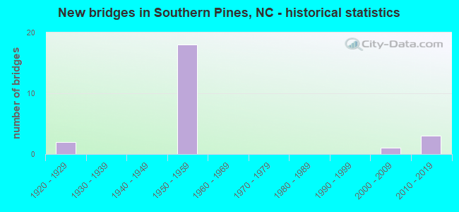
- New bridges - historical statistics
- 21920-1929
- 181950-1959
- 12000-2009
- 32010-2019

- Reconstructed bridges - Historical Statistics
- 11930-1939
- 01940-1949
- 01950-1959
- 01960-1969
- 01970-1979
- 11980-1989


- Bridge Condition - Deck
- 27.3%Good
- 54.5%Satisfactory
- 18.2%Fair

- Bridge Condition - Superstructure
- 27.3%Good
- 45.5%Satisfactory
- 27.3%Fair

- Bridge Condition - Substructure
- 18.2%Good
- 45.5%Satisfactory
- 36.4%Fair

- Bridge Condition - Channel
- 60.0%Good
- 40.0%Satisfactory
Find on map >> Show street view
Structure Number: 1250032, Location: 0.8 MI. N. JCT. US15/501 (Lat: 35.165156, Lng: -79.407744), Route carried "on" structure: US 1, Year Built: 1957, Status: Open, Structure Length: 5.82m (19.09ft), Average Daily Traffic: 11,000 (year 2012), Truck Traffic: 12%, Average Future Daily Traffic: 22,000 (year 2025), Design Load: HS 20+Mod, Features Intersected: SR2080 WBL
Minimum Vertical Clearance: 30+ m (98+ ft), Kilometerpoint: 0.000, Lanes on structure: 2, Lanes under structure: 1, Base Highway Network: Yes (Inventory Route: 2, Subroute: 1), Owner: State Highway Agency, Approaching Roadway Width: 7.6m (24.9ft), Skew: 4 degrees, Material/Design: Steel, Design/Construction: Stringer/Multi-beam, Number Of Spans In Main Unit: 4, Length of Maximum Span: 18.8m (61.7ft), Curb or Sidewalk Widths: Left: 0.2m (0.7ft), Right: 0.2m (0.7ft), Curb-To-Curb Width: 8.5m (27.9ft), Out-to-Out Width: 9.6m (31.5ft)
Condition: Deck: Satisfactory, Superstructure: Satisfactory, Substructure: Fair, Operating Rating: 53.5 metric tons, Method Used To Determine Operating Rating: Load Factor (LF), Inventory Rating: 31.7 metric tons, Method Used To Determine Inventory Rating: Load Factor (LF), Structural Evaluation: Somewhat better than minimum adequacy, Deck Geometry: High priority of replacement, Underclear: Somewhat better than minimum adequacy, Approach Roadway Alignment: Equal to present desirable criteria, Designated Inspection Frequency: Every 24 months, Inspection Date: August 2020, Deck Structure Type: Concrete Cast-file-Place, Wearing Surface/Protective System: Wearing Surface: Bituminous
Find on map >> Show street view
Structure Number: 1250035, Location: 0.5 MI. S. JCT. SR1853 (Lat: 35.216719, Lng: -79.358703), Route carried "on" structure: State highway 1802, Year Built: 2008, Status: Open, Structure Length: 0.76m (2.49ft), Average Daily Traffic: 2,400 (year 2018), Truck Traffic: 7%, Average Future Daily Traffic: 4,800 (year 2040), Design Load: HS 20+Mod, Features Intersected: MCDEEDS CREEK
Minimum Vertical Clearance: 30+ m (98+ ft), Kilometerpoint: 0.000, Lanes on structure: 2, Owner: State Highway Agency, Approaching Roadway Width: 7.0m (23.0ft), Skew: 1 degrees, Material/Design: Steel, Design/Construction: Culvert, Number Of Spans In Main Unit: 2, Length of Maximum Span: 3.0m (9.8ft)
Condition: Channel: Satisfactory, Culverts: Satisfactory, Operating Rating: 89.8 metric tons, Method Used To Determine Operating Rating: Load and Resistance Factor (LRFR), Inventory Rating: 89.8 metric tons, Method Used To Determine Inventory Rating: Load and Resistance Factor (LRFR), Structural Evaluation: Equal to present minimum criteria, Waterway Adequacy: Equal to present minimum criteria, Approach Roadway Alignment: Equal to present desirable criteria, Designated Inspection Frequency: Every 24 months, Inspection Date: March 2021
Find on map >> Show street view
Structure Number: 125004, Location: 0.3 MI. W. JCT. SR1640 (Lat: 35.370436, Lng: -79.450758), Route carried "on" structure: State highway 22, Year Built: 1921, Year Reconstructed: 1941, Status: Open, Structure Length: 0.97m (3.18ft), Average Daily Traffic: 7,200 (year 2015), Truck Traffic: 8%, Average Future Daily Traffic: 14,400 (year 2040), Design Load: H 15, Features Intersected: KILLETS CREEK
Minimum Vertical Clearance: 30+ m (98+ ft), Kilometerpoint: 0.000, Lanes on structure: 2, Base Highway Network: Yes (Inventory Route: 3, Subroute: 22), Owner: State Highway Agency, Approaching Roadway Width: 8.8m (28.9ft), Material/Design: Concrete, Design/Construction: Tee Beam, Number Of Spans In Main Unit: 1, Length of Maximum Span: 9.1m (29.9ft), Curb or Sidewalk Widths: Left: 0.3m (1.0ft), Right: 0.3m (1.0ft), Curb-To-Curb Width: 9.7m (31.8ft), Out-to-Out Width: 10.9m (35.8ft)
Condition: Deck: Satisfactory, Superstructure: Good, Substructure: Satisfactory, Channel: Good, Operating Rating: 46.2 metric tons, Method Used To Determine Operating Rating: Load Factor (LF), Inventory Rating: 27.2 metric tons, Method Used To Determine Inventory Rating: Load Factor (LF), Structural Evaluation: Equal to present minimum criteria, Deck Geometry: High priority of corrective action, Waterway Adequacy: Better than present minimum criteria, Approach Roadway Alignment: Equal to present desirable criteria, Designated Inspection Frequency: Every 24 months, Inspection Date: May 2021, Deck Structure Type: Concrete Cast-file-Place, Wearing Surface/Protective System: Wearing Surface: Bituminous
Find on map >> Show street view
Structure Number: 1250041, Location: 1.2 MI. E. JCT. US15/501 (Lat: 35.170128, Lng: -79.405972), Route carried "on" structure: State highway 1309, Year Built: 2014, Status: Open, Structure Length: 5.12m (16.80ft), Average Daily Traffic: 17,000 (year 2012), Average Future Daily Traffic: 34,000 (year 2040), Design Load: HL 93, Features Intersected: US1
Minimum Vertical Clearance: 30+ m (98+ ft), Kilometerpoint: 0.000, Lanes on structure: 6, Lanes under structure: 5, Owner: State Highway Agency, Approaching Roadway Width: 16.4m (53.8ft), Material/Design: Steel continuous, Design/Construction: Stringer/Multi-beam, Number Of Spans In Main Unit: 2, Length of Maximum Span: 26.8m (87.9ft), Curb or Sidewalk Widths: Left: 1.6m (5.2ft), Right: 1.6m (5.2ft), Curb-To-Curb Width: 23.7m (77.8ft), Out-to-Out Width: 27.8m (91.2ft)
Condition: Deck: Good, Superstructure: Good, Substructure: Good, Operating Rating: 87.9 metric tons, Method Used To Determine Operating Rating: Load and Resistance Factor (LRFR), Inventory Rating: 68.0 metric tons, Method Used To Determine Inventory Rating: Load and Resistance Factor (LRFR), Structural Evaluation: Better than present minimum criteria, Deck Geometry: Somewhat better than minimum adequacy, Underclear: High priority of corrective action, Approach Roadway Alignment: Equal to present desirable criteria, Designated Inspection Frequency: Every 24 months, Inspection Date: July 2020, Deck Structure Type: Concrete Cast-file-Place, Wearing Surface/Protective System: Wearing Surface: Monolithic Concrete, Deck Protection: Epoxy Coated Reinforcing
Find on map >> Show street view
Structure Number: 1250044, Location: 0.4 MI. W. JCT. SR2035 (Lat: 35.179222, Lng: -79.396908), Route carried "on" structure: State highway 1848, Year Built: 1957, Status: Posted for load, Structure Length: 5.33m (17.49ft), Average Daily Traffic: 3,700 (year 2018), Truck Traffic: 6%, Average Future Daily Traffic: 7,400 (year 2040), Design Load: HS 15, Features Intersected: US1
Minimum Vertical Clearance: 30+ m (98+ ft), Kilometerpoint: 0.000, Lanes on structure: 3, Lanes under structure: 4, Owner: State Highway Agency, Approaching Roadway Width: 16.1m (52.8ft), Skew: 1 degrees, Material/Design: Steel, Design/Construction: Stringer/Multi-beam, Number Of Spans In Main Unit: 4, Length of Maximum Span: 15.8m (51.8ft), Curb or Sidewalk Widths: Left: 1.5m (4.9ft), Right: 1.5m (4.9ft), Curb-To-Curb Width: 13.4m (44.0ft), Out-to-Out Width: 16.9m (55.4ft)
Condition: Deck: Satisfactory, Superstructure: Satisfactory, Substructure: Fair, Operating Rating: 39.9 metric tons, Method Used To Determine Operating Rating: Load Factor (LF), Inventory Rating: 23.5 metric tons, Method Used To Determine Inventory Rating: Load Factor (LF), Structural Evaluation: Somewhat better than minimum adequacy, Deck Geometry: Somewhat better than minimum adequacy, Underclear: High priority of corrective action, Approach Roadway Alignment: Equal to present desirable criteria, Bridge Posting: Required (Relationship of Operating Rating to Maximum Legal Load: 0.1 - 9.9% below), Designated Inspection Frequency: Every 24 months, Inspection Date: April 2021, Deck Structure Type: Concrete Cast-file-Place, Wearing Surface/Protective System: Wearing Surface: Bituminous
Find on map >> Show street view
Structure Number: 1250045, Location: 1.1 MI. N. JCT. SR1848 (Lat: 35.190764, Lng: -79.384783), Route carried "on" structure: US 1, Year Built: 1957, Status: Open, Structure Length: 4.87m (15.98ft), Average Daily Traffic: 12,250 (year 2018), Truck Traffic: 12%, Average Future Daily Traffic: 24,500 (year 2040), Design Load: HS 20+Mod, Features Intersected: NC2 & NC22
Minimum Vertical Clearance: 30+ m (98+ ft), Kilometerpoint: 0.000, Lanes on structure: 2, Lanes under structure: 4, Base Highway Network: Yes (Inventory Route: 2, Subroute: 1), Owner: State Highway Agency, Approaching Roadway Width: 7.3m (24.0ft), Skew: 10 degrees, Material/Design: Steel, Design/Construction: Stringer/Multi-beam, Number Of Spans In Main Unit: 4, Length of Maximum Span: 13.4m (44.0ft), Curb or Sidewalk Widths: Left: 0.4m (1.3ft), Right: 0.4m (1.3ft), Curb-To-Curb Width: 8.5m (27.9ft), Out-to-Out Width: 10.1m (33.1ft)
Condition: Deck: Satisfactory, Superstructure: Fair, Substructure: Fair, Operating Rating: 43.5 metric tons, Method Used To Determine Operating Rating: Load Factor (LF), Inventory Rating: 26.3 metric tons, Method Used To Determine Inventory Rating: Load Factor (LF), Structural Evaluation: Somewhat better than minimum adequacy, Deck Geometry: High priority of replacement, Underclear: Somewhat better than minimum adequacy, Approach Roadway Alignment: Equal to present desirable criteria, Designated Inspection Frequency: Every 24 months, Inspection Date: May 2021, Deck Structure Type: Concrete Cast-file-Place, Wearing Surface/Protective System: Wearing Surface: Bituminous
Find on map >> Show street view
Structure Number: 125005, Location: 1.1 MI. N. JCT. SR1848 (Lat: 35.190889, Lng: -79.384858), Route carried "on" structure: US 1, Year Built: 1957, Status: Open, Structure Length: 4.87m (15.98ft), Average Daily Traffic: 12,000 (year 2018), Truck Traffic: 12%, Average Future Daily Traffic: 24,000 (year 2040), Design Load: HS 20+Mod, Features Intersected: NC2,NC22
Minimum Vertical Clearance: 30+ m (98+ ft), Kilometerpoint: 0.000, Lanes on structure: 2, Lanes under structure: 4, Base Highway Network: Yes (Inventory Route: 2, Subroute: 1), Owner: State Highway Agency, Approaching Roadway Width: 7.3m (24.0ft), Skew: 10 degrees, Material/Design: Steel, Design/Construction: Stringer/Multi-beam, Number Of Spans In Main Unit: 4, Length of Maximum Span: 13.4m (44.0ft), Curb or Sidewalk Widths: Left: 0.5m (1.6ft), Right: 0.5m (1.6ft), Curb-To-Curb Width: 8.5m (27.9ft), Out-to-Out Width: 10.1m (33.1ft)
Condition: Deck: Satisfactory, Superstructure: Fair, Substructure: Satisfactory, Operating Rating: 46.2 metric tons, Method Used To Determine Operating Rating: Load Factor (LF), Inventory Rating: 28.1 metric tons, Method Used To Determine Inventory Rating: Load Factor (LF), Structural Evaluation: Somewhat better than minimum adequacy, Deck Geometry: High priority of replacement, Underclear: Somewhat better than minimum adequacy, Approach Roadway Alignment: Equal to present desirable criteria, Designated Inspection Frequency: Every 24 months, Inspection Date: May 2021, Deck Structure Type: Concrete Cast-file-Place, Wearing Surface/Protective System: Wearing Surface: Bituminous
Find on map >> Show street view
Structure Number: 1250056, Location: 1.7 MI. N. JCT.NC2 & NC22 (Lat: 35.201472, Lng: -79.358222), Route carried "on" structure: US 1, Year Built: 1957, Status: Open, Structure Length: 8.44m (27.69ft), Average Daily Traffic: 9,000 (year 2013), Truck Traffic: 12%, Average Future Daily Traffic: 18,000 (year 2040), Design Load: HS 20+Mod, Features Intersected: SR1857 & SEABOARD RR
Minimum Vertical Clearance: 30+ m (98+ ft), Kilometerpoint: 0.000, Lanes on structure: 2, Lanes under structure: 2, Base Highway Network: Yes (Inventory Route: 2, Subroute: 1), Owner: State Highway Agency, Approaching Roadway Width: 7.6m (24.9ft), Skew: 14 degrees, Material/Design: Steel, Design/Construction: Stringer/Multi-beam, Number Of Spans In Main Unit: 5, Length of Maximum Span: 18.2m (59.7ft), Curb or Sidewalk Widths: Left: 0.4m (1.3ft), Right: 0.4m (1.3ft), Curb-To-Curb Width: 8.6m (28.2ft), Out-to-Out Width: 10.2m (33.5ft)
Condition: Deck: Fair, Superstructure: Fair, Substructure: Satisfactory, Operating Rating: 69.8 metric tons, Method Used To Determine Operating Rating: Load Factor (LF), Inventory Rating: 41.7 metric tons, Method Used To Determine Inventory Rating: Load Factor (LF), Structural Evaluation: Somewhat better than minimum adequacy, Deck Geometry: High priority of corrective action, Underclear: Somewhat better than minimum adequacy, Approach Roadway Alignment: Equal to present desirable criteria, Designated Inspection Frequency: Every 24 months, Inspection Date: August 2020, Deck Structure Type: Concrete Cast-file-Place, Wearing Surface/Protective System: Wearing Surface: Bituminous
Find on map >> Show street view
Structure Number: 1250057, Location: 1.7 MI.N.JCT.NC2 & NC22 (Lat: 35.201653, Lng: -79.358064), Route carried "on" structure: US 1, Year Built: 1957, Status: Open, Structure Length: 8.44m (27.69ft), Average Daily Traffic: 18,000 (year 2013), Truck Traffic: 12%, Average Future Daily Traffic: 36,000 (year 2040), Design Load: HS 20+Mod, Features Intersected: SR1857 & SEABOARD RR
Minimum Vertical Clearance: 30+ m (98+ ft), Kilometerpoint: 0.000, Lanes on structure: 2, Lanes under structure: 2, Base Highway Network: Yes (Inventory Route: 2, Subroute: 1), Owner: State Highway Agency, Approaching Roadway Width: 7.3m (24.0ft), Skew: 14 degrees, Material/Design: Steel, Design/Construction: Stringer/Multi-beam, Number Of Spans In Main Unit: 5, Length of Maximum Span: 18.2m (59.7ft), Curb or Sidewalk Widths: Left: 0.4m (1.3ft), Right: 0.4m (1.3ft), Curb-To-Curb Width: 8.5m (27.9ft), Out-to-Out Width: 10.2m (33.5ft)
Condition: Deck: Fair, Superstructure: Satisfactory, Substructure: Fair, Operating Rating: 58.0 metric tons, Method Used To Determine Operating Rating: Load Factor (LF), Inventory Rating: 34.4 metric tons, Method Used To Determine Inventory Rating: Load Factor (LF), Structural Evaluation: Somewhat better than minimum adequacy, Deck Geometry: High priority of corrective action, Underclear: Somewhat better than minimum adequacy, Approach Roadway Alignment: Equal to present desirable criteria, Designated Inspection Frequency: Every 24 months, Inspection Date: August 2020, Deck Structure Type: Concrete Cast-file-Place, Wearing Surface/Protective System: Wearing Surface: Bituminous
Find on map >> Show street view
Structure Number: 125018, Location: 0.9 MI. W. JCT. SR1407 (Lat: 35.480506, Lng: -79.716189), Route carried "on" structure: State highway 1409, Year Built: 1959, Year Reconstructed: 1985, Status: Open, Structure Length: 2.31m (7.58ft), Average Daily Traffic: 370 (year 2015), Truck Traffic: 6%, Average Future Daily Traffic: 740 (year 2040), Features Intersected: BEAR CREEK
Minimum Vertical Clearance: 30+ m (98+ ft), Kilometerpoint: 0.000, Lanes on structure: 2, Owner: State Highway Agency, Approaching Roadway Width: 5.7m (18.7ft), Material/Design: Steel, Design/Construction: Stringer/Multi-beam, Number Of Spans In Main Unit: 3, Length of Maximum Span: 12.1m (39.7ft), Curb-To-Curb Width: 6.8m (22.3ft), Out-to-Out Width: 7.0m (23.0ft)
Condition: Deck: Good, Superstructure: Satisfactory, Substructure: Satisfactory, Channel: Satisfactory, Operating Rating: 48.0 metric tons, Method Used To Determine Operating Rating: Load Factor (LF), Inventory Rating: 29.0 metric tons, Method Used To Determine Inventory Rating: Load Factor (LF), Structural Evaluation: Equal to present minimum criteria, Deck Geometry: Meets minimum limits, Waterway Adequacy: Better than present minimum criteria, Approach Roadway Alignment: Equal to present desirable criteria, Designated Inspection Frequency: Every 24 months, Inspection Date: April 2021, Deck Structure Type: Corrugated Steel, Wearing Surface/Protective System: Wearing Surface: Bituminous
Find on map >> Show street view
Structure Number: 1250185, Location: 0.1 MI. N. JCT. US15/501 (Lat: 35.237642, Lng: -79.447708), Route carried "on" structure: State highway 1285, Year Built: 1924, Status: Posted for load, Structure Length: 1.61m (5.28ft), Average Daily Traffic: 560 (year 2016), Truck Traffic: 6%, Average Future Daily Traffic: 1,120 (year 2040), Design Load: H 15, Features Intersected: NICK'S CREEK
Minimum Vertical Clearance: 30+ m (98+ ft), Kilometerpoint: 0.000, Lanes on structure: 2, Owner: State Highway Agency, Approaching Roadway Width: 5.4m (17.7ft), Material/Design: Concrete, Design/Construction: Girder and Floorbeam System, Number Of Spans In Main Unit: 1, Length of Maximum Span: 16.1m (52.8ft), Curb or Sidewalk Widths: Left: 0.1m (0.3ft), Right: 0.1m (0.3ft), Curb-To-Curb Width: 6.0m (19.7ft), Out-to-Out Width: 7.8m (25.6ft)
Condition: Deck: Good, Superstructure: Good, Substructure: Good, Channel: Good, Operating Rating: 24.4 metric tons, Method Used To Determine Operating Rating: Load Factor (LF), Inventory Rating: 14.5 metric tons, Method Used To Determine Inventory Rating: Load Factor (LF), Structural Evaluation: Meets minimum limits, Deck Geometry: High priority of replacement, Waterway Adequacy: Better than present minimum criteria, Approach Roadway Alignment: Equal to present desirable criteria, Bridge Posting: Required (Relationship of Operating Rating to Maximum Legal Load: 30.0 - 39.9% below), Designated Inspection Frequency: Every 24 months, Inspection Date: October 2021, Deck Structure Type: Concrete Cast-file-Place, Wearing Surface/Protective System: Wearing Surface: Bituminous
Find on map >> Show street view
Structure Number: 1250187, Location: 0.3 MI. E. JCT. US1 (Lat: 35.159928, Lng: -79.405217), Route carried "on" structure: State highway 2053, Year Built: 1956, Status: Posted for load, Structure Length: 5.02m (16.47ft), Average Daily Traffic: 8,000 (year 2016), Truck Traffic: 6%, Average Future Daily Traffic: 16,000 (year 2040), Design Load: HS 15, Features Intersected: SEABOARD COASTLINE RR
Minimum Vertical Clearance: 30+ m (98+ ft), Kilometerpoint: 0.000, Lanes on structure: 2, Owner: State Highway Agency, Approaching Roadway Width: 7.3m (24.0ft), Material/Design: Steel, Design/Construction: Stringer/Multi-beam, Number Of Spans In Main Unit: 3, Length of Maximum Span: 16.4m (53.8ft), Curb or Sidewalk Widths: Left: 0.3m (1.0ft), Right: 0.3m (1.0ft), Curb-To-Curb Width: 7.3m (24.0ft), Out-to-Out Width: 8.6m (28.2ft)
Condition: Deck: Satisfactory, Superstructure: Satisfactory, Substructure: Satisfactory, Operating Rating: 29.9 metric tons, Method Used To Determine Operating Rating: Load Factor (LF), Inventory Rating: 18.1 metric tons, Method Used To Determine Inventory Rating: Load Factor (LF), Structural Evaluation: Meets minimum limits, Deck Geometry: High priority of replacement, Underclear: Somewhat better than minimum adequacy, Approach Roadway Alignment: Equal to present desirable criteria, Bridge Posting: Required (Relationship of Operating Rating to Maximum Legal Load: 0.1 - 9.9% below), Designated Inspection Frequency: Every 24 months, Inspection Date: July 2021, Deck Structure Type: Concrete Cast-file-Place, Wearing Surface/Protective System: Wearing Surface: Bituminous
Find on map >> Show street view
Structure Number: 1250211, Location: 0.05 MI. N. JCT. SR1285 (Lat: 35.237608, Lng: -79.447472), Route carried "on" structure: US 15, Year Built: 1950, Status: Open, Structure Length: 1.12m (3.67ft), Average Daily Traffic: 12,500 (year 2019), Truck Traffic: 14%, Average Future Daily Traffic: 25,000 (year 2040), Design Load: HS 20+Mod, Features Intersected: NICK'S CREEK
Minimum Vertical Clearance: 30+ m (98+ ft), Kilometerpoint: 0.000, Lanes on structure: 3, Base Highway Network: Yes (Inventory Route: 2, Subroute: 15), Owner: State Highway Agency, Approaching Roadway Width: 16.7m (54.8ft), Material/Design: Concrete continuous, Design/Construction: Culvert, Number Of Spans In Main Unit: 3, Length of Maximum Span: 3.6m (11.8ft)
Condition: Channel: Good, Culverts: Satisfactory, Operating Rating: 41.7 metric tons, Method Used To Determine Operating Rating: Field evaluation and documented engineering judgment, Inventory Rating: 32.6 metric tons, Method Used To Determine Inventory Rating: Field evaluation and documented engineering judgment, Structural Evaluation: Equal to present minimum criteria, Waterway Adequacy: Better than present minimum criteria, Approach Roadway Alignment: Equal to present desirable criteria, Designated Inspection Frequency: Every 24 months, Inspection Date: May 2021
Find on map >> Show street view
Structure Number: 1250032, Location: 0.8 MI. N. JCT. US15/501 (Lat: 35.165156, Lng: -79.407744), Route carried "under" structure: State highway 2080, Year Built: 1957, Structure Length: 0. m, Average Daily Traffic: 9,900 (year 2013), Truck Traffic: 6%, Features Intersected: US1 NBL
Minimum Vertical Clearance: 4.77m (15.65ft), Kilometerpoint: 0.000, Lanes on structure: 2, Lanes under structure: 1, Material/Design: Steel, Design/Construction: Stringer/Multi-beam, Length of Maximum Span: 18.8m (61.7ft)
Find on map >> Show street view
Structure Number: 1250041, Location: 1.2 MI. E. JCT. US15/501 (Lat: 35.170128, Lng: -79.405972), Route carried "under" structure: US 1, Year Built: 2014, Structure Length: 0. m, Average Daily Traffic: 11,000 (year 2012), Truck Traffic: 12%, Features Intersected: SR1309
Minimum Vertical Clearance: 5.28m (17.32ft), Kilometerpoint: 0.000, Lanes on structure: 6, Lanes under structure: 3, Material/Design: Steel continuous, Design/Construction: Stringer/Multi-beam, Length of Maximum Span: 26.8m (87.9ft)
Find on map >> Show street view
Structure Number: 1250041, Location: 1.2 MI. E. JCT. US15/501 (Lat: 35.170128, Lng: -79.405972), Route carried "under" structure: US 1, Year Built: 2014, Structure Length: 0. m, Average Daily Traffic: 11,000 (year 2012), Truck Traffic: 12%, Features Intersected: SR1309
Minimum Vertical Clearance: 5.10m (16.73ft), Kilometerpoint: 0.000, Lanes on structure: 6, Lanes under structure: 2, Material/Design: Steel continuous, Design/Construction: Stringer/Multi-beam, Length of Maximum Span: 26.8m (87.9ft)
Find on map >> Show street view
Structure Number: 1250044, Location: 0.4 MI. W. JCT. SR2035 (Lat: 35.179222, Lng: -79.396908), Route carried "under" structure: US 1, Year Built: 1957, Structure Length: 0. m, Average Daily Traffic: 14,500 (year 2018), Truck Traffic: 12%, Features Intersected: SR1848
Minimum Vertical Clearance: 4.67m (15.32ft), Kilometerpoint: 0.000, Lanes on structure: 3, Lanes under structure: 2, Material/Design: Steel, Design/Construction: Stringer/Multi-beam, Length of Maximum Span: 15.8m (51.8ft)
Find on map >> Show street view
Structure Number: 1250044, Location: 0.4 MI. W. JCT. SR2035 (Lat: 35.179222, Lng: -79.396908), Route carried "under" structure: US 1, Year Built: 1957, Structure Length: 0. m, Average Daily Traffic: 14,500 (year 2018), Truck Traffic: 12%, Features Intersected: SR1848
Minimum Vertical Clearance: 4.74m (15.55ft), Kilometerpoint: 0.000, Lanes on structure: 3, Lanes under structure: 2, Material/Design: Steel, Design/Construction: Stringer/Multi-beam, Length of Maximum Span: 15.8m (51.8ft)
Find on map >> Show street view
Structure Number: 1250045, Location: 1.1 MI. N. JCT. SR1848 (Lat: 35.190764, Lng: -79.384783), Route carried "under" structure: State highway 2, Year Built: 1957, Structure Length: 0. m, Average Daily Traffic: 7,000 (year 2015), Truck Traffic: 12%, Features Intersected: US1 NBL
Minimum Vertical Clearance: 4.52m (14.83ft), Kilometerpoint: 0.000, Lanes on structure: 2, Lanes under structure: 2, Material/Design: Steel, Design/Construction: Stringer/Multi-beam, Length of Maximum Span: 13.4m (44.0ft)
Find on map >> Show street view
Structure Number: 1250045, Location: 1.1 MI. N. JCT. SR1848 (Lat: 35.190764, Lng: -79.384783), Route carried "under" structure: State highway 2, Year Built: 1957, Structure Length: 0. m, Average Daily Traffic: 7,000 (year 2015), Truck Traffic: 12%, Features Intersected: US1 NBL
Minimum Vertical Clearance: 4.41m (14.47ft), Kilometerpoint: 0.000, Lanes on structure: 2, Lanes under structure: 2, Material/Design: Steel, Design/Construction: Stringer/Multi-beam, Length of Maximum Span: 13.4m (44.0ft)
Find on map >> Show street view
Structure Number: 125005, Location: 1.1 MI. N. JCT. SR1848 (Lat: 35.190889, Lng: -79.384858), Route carried "under" structure: State highway 2, Year Built: 1957, Structure Length: 0. m, Average Daily Traffic: 7,000 (year 2015), Truck Traffic: 12%, Features Intersected: US1 SBL
Minimum Vertical Clearance: 4.57m (14.99ft), Kilometerpoint: 0.000, Lanes on structure: 2, Lanes under structure: 2, Material/Design: Steel, Design/Construction: Stringer/Multi-beam, Length of Maximum Span: 13.4m (44.0ft)
Find on map >> Show street view
Structure Number: 125005, Location: 1.1 MI. N. JCT. SR1848 (Lat: 35.190889, Lng: -79.384858), Route carried "under" structure: State highway 2, Year Built: 1957, Structure Length: 0. m, Average Daily Traffic: 7,000 (year 2015), Truck Traffic: 12%, Features Intersected: US1 SBL
Minimum Vertical Clearance: 4.41m (14.47ft), Kilometerpoint: 0.000, Lanes on structure: 2, Lanes under structure: 2, Material/Design: Steel, Design/Construction: Stringer/Multi-beam, Length of Maximum Span: 13.4m (44.0ft)
Find on map >> Show street view
Structure Number: 1250056, Location: 1.7 MI. N. JCT.NC2 & NC22 (Lat: 35.201472, Lng: -79.358222), Route carried "under" structure: State highway 1857, Year Built: 1957, Structure Length: 0. m, Average Daily Traffic: 1,800 (year 2013), Truck Traffic: 7%, Features Intersected: US1 NBL
Minimum Vertical Clearance: 6.90m (22.64ft), Kilometerpoint: 0.000, Lanes on structure: 2, Lanes under structure: 2, Material/Design: Steel, Design/Construction: Stringer/Multi-beam, Length of Maximum Span: 18.2m (59.7ft)
Find on map >> Show street view
Structure Number: 1250057, Location: 1.7 MI.N.JCT.NC2 & NC22 (Lat: 35.201653, Lng: -79.358064), Route carried "under" structure: State highway 1857, Year Built: 1957, Structure Length: 0. m, Average Daily Traffic: 1,800 (year 2015), Truck Traffic: 7%, Features Intersected: US1 SBL
Minimum Vertical Clearance: 6.85m (22.47ft), Kilometerpoint: 0.000, Lanes on structure: 2, Lanes under structure: 2, Material/Design: Steel, Design/Construction: Stringer/Multi-beam, Length of Maximum Span: 18.2m (59.7ft)