Bridge Statistics for South Holland, Illinois (IL)
Condition, Traffic, Stress, Structural Evaluation, Project Costs
- National Bridge Inventory (NBI) Statistics
- 35Number of bridges
- 1,014ft / 309mTotal length
- $8,051,000Total costs
- 1,812,100Total average daily traffic
- 362,893Total average daily truck traffic
- National Bridge Inventory (NBI) Registered Bridges for South Holland
- No street view available for this location
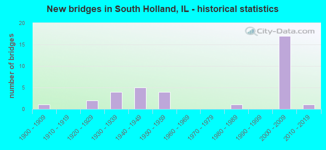
- New bridges - historical statistics
- 11900-1909
- 21920-1929
- 41930-1939
- 51940-1949
- 41950-1959
- 11980-1989
- 172000-2009
- 12010-2019
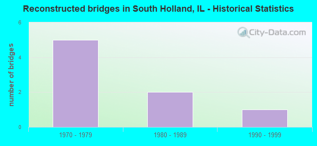
- Reconstructed bridges - Historical Statistics
- 51970-1979
- 21980-1989
- 11990-1999
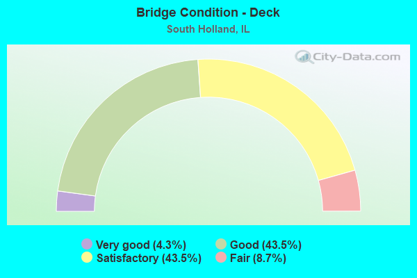
- Bridge Condition - Deck
- 4.3%Very good
- 43.5%Good
- 43.5%Satisfactory
- 8.7%Fair
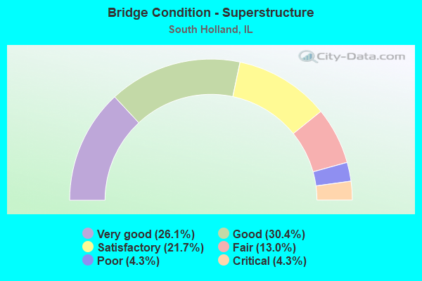
- Bridge Condition - Superstructure
- 26.1%Very good
- 30.4%Good
- 21.7%Satisfactory
- 13.0%Fair
- 4.3%Poor
- 4.3%Critical
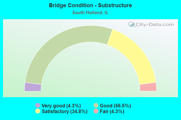
- Bridge Condition - Substructure
- 4.3%Very good
- 56.5%Good
- 34.8%Satisfactory
- 4.3%Fair
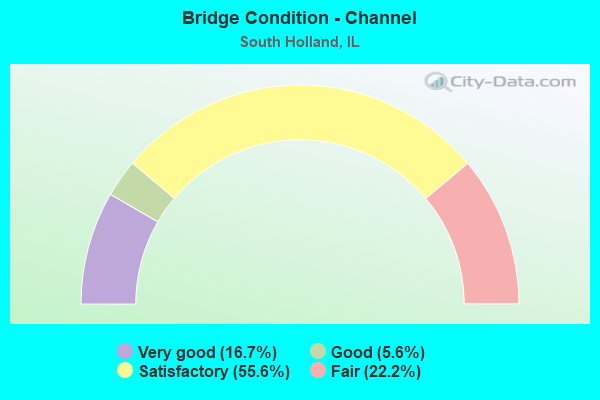
- Bridge Condition - Channel
- 16.7%Very good
- 5.6%Good
- 55.6%Satisfactory
- 22.2%Fair
Find on map >> Show street view
Structure Number: 160163, Location: 1.1 M S IL 83 (Lat: 41.607197, Lng: -87.581786), Route carried "on" structure: Interstate 94, Year Built: 1947, Year Reconstructed: 1981, Status: Open, Structure Length: 8.24m (27.03ft), Average Daily Traffic: 129,700 (year 2021), Truck Traffic: 10%, Average Future Daily Traffic: 144,715 (year 2032), Design Load: HS 20, Features Intersected: LITTLE CAL RIVER
Minimum Vertical Clearance: 30+ m (98+ ft), Kilometerpoint: 116.690, Lanes on structure: 6, Base Highway Network: Yes, Owner: State Highway Agency, Approaching Roadway Width: 33.8m (110.9ft), Skew: 31 degrees, Material/Design: Steel continuous, Design/Construction: Stringer/Multi-beam, Number Of Spans In Main Unit: 3, Length of Maximum Span: 31.7m (104.0ft), Curb-To-Curb Width: 33.8m (110.9ft), Out-to-Out Width: 35.7m (117.1ft)
Condition: Deck: Satisfactory, Superstructure: Fair, Substructure: Satisfactory, Channel: Satisfactory, Operating Rating: 80.0 metric tons, Method Used To Determine Operating Rating: Load Factor (LF) rating reported by rating factor (RF) method using MS18 loading, Inventory Rating: 43.7 metric tons, Method Used To Determine Inventory Rating: Load Factor (LF) rating reported by rating factor (RF) method using MS18 loading, Structural Evaluation: Somewhat better than minimum adequacy, Deck Geometry: Superior to present desirable criteria, Waterway Adequacy: Superior to present desirable criteria, Approach Roadway Alignment: Equal to present desirable criteria, Designated Inspection Frequency: Every 24 months, Inspection Date: September 2020, Deck Structure Type: Concrete Cast-file-Place, Wearing Surface/Protective System: Wearing Surface: Epoxy Overlay, Deck Protection: Epoxy Coated Reinforcing
Find on map >> Show street view
Structure Number: 160386, Location: 0.9 M E IL 1 (Lat: 41.600903, Lng: -87.618375), Route carried "on" structure: US 6, Year Built: 1953, Status: Open, Structure Length: 0.91m (2.99ft), Average Daily Traffic: 26,700 (year 2021), Truck Traffic: 7%, Average Future Daily Traffic: 26,368 (year 2032), Design Load: HS 20, Features Intersected: CAL UNION DITCH
Minimum Vertical Clearance: 30+ m (98+ ft), Kilometerpoint: 279.841, Lanes on structure: 4, Base Highway Network: Yes, Owner: State Highway Agency, Approaching Roadway Width: 21.3m (69.9ft), Skew: 22 degrees, Material/Design: Concrete, Design/Construction: Slab, Number Of Spans In Main Unit: 1, Length of Maximum Span: 8.5m (27.9ft), Curb-To-Curb Width: 20.2m (66.3ft), Out-to-Out Width: 21.3m (69.9ft)
Condition: Deck: Satisfactory, Superstructure: Satisfactory, Substructure: Satisfactory, Channel: Fair, Operating Rating: 55.4 metric tons, Method Used To Determine Operating Rating: Load Factor (LF) rating reported by rating factor (RF) method using MS18 loading, Inventory Rating: 33.0 metric tons, Method Used To Determine Inventory Rating: Load Factor (LF) rating reported by rating factor (RF) method using MS18 loading, Structural Evaluation: Equal to present minimum criteria, Deck Geometry: Better than present minimum criteria, Waterway Adequacy: Equal to present desirable criteria, Approach Roadway Alignment: Equal to present desirable criteria, Designated Inspection Frequency: Every 24 months, Inspection Date: Febuary 2022, Deck Structure Type: Concrete Cast-file-Place, Wearing Surface/Protective System: Wearing Surface: Latex Concrete
Find on map >> Show street view
Structure Number: 160388, Location: 0.7 E COTTAGE GROVE (Lat: 41.600872, Lng: -87.583508), Route carried "on" structure: US 6, Year Built: 1947, Year Reconstructed: 1987, Status: Temporarily open, Structure Length: 7.02m (23.03ft), Average Daily Traffic: 24,900 (year 2021), Truck Traffic: 4%, Average Future Daily Traffic: 33,063 (year 2032), Design Load: H 20, Features Intersected: I- 94 BISHOP FORD
Minimum Vertical Clearance: 30+ m (98+ ft), Kilometerpoint: 282.738, Lanes on structure: 6, Lanes under structure: 8, Base Highway Network: Yes, Owner: State Highway Agency, Approaching Roadway Width: 17.7m (58.1ft), Skew: 30 degrees, Material/Design: Steel continuous, Design/Construction: Stringer/Multi-beam, Number Of Spans In Main Unit: 4, Length of Maximum Span: 19.2m (63.0ft), Curb or Sidewalk Widths: Left: 1.5m (4.9ft), Right: 1.5m (4.9ft), Curb-To-Curb Width: 23.8m (78.1ft), Out-to-Out Width: 28.0m (91.9ft)
Condition: Deck: Fair, Superstructure: Critical, Substructure: Satisfactory, Operating Rating: 29.5 metric tons, Method Used To Determine Operating Rating: Load Factor (LF) rating reported by rating factor (RF) method using MS18 loading, Inventory Rating: 17.5 metric tons, Method Used To Determine Inventory Rating: Load Factor (LF) rating reported by rating factor (RF) method using MS18 loading, Structural Evaluation: High priority of replacement, Deck Geometry: Somewhat better than minimum adequacy, Underclear: Meets minimum limits, Approach Roadway Alignment: Equal to present desirable criteria, Designated Inspection Frequency: Every 12 months, Other Special Inspection Frequency: Every 6 months, Inspection Date: December 2021, Other Special Inspection Date: December 2021, Deck Structure Type: Concrete Cast-file-Place
Find on map >> Show street view
Structure Number: 160389, Location: 0.1 M E I-94 BF (Lat: 41.600897, Lng: -87.577969), Route carried "on" structure: US 6, Year Built: 1931, Year Reconstructed: 1981, Status: Open, Structure Length: 4.96m (16.27ft), Average Daily Traffic: 24,900 (year 2021), Truck Traffic: 4%, Average Future Daily Traffic: 33,063 (year 2032), Design Load: HS 20, Features Intersected: LITTLE CAL RIVER
Minimum Vertical Clearance: 30+ m (98+ ft), Kilometerpoint: 283.221, Lanes on structure: 5, Base Highway Network: Yes, Owner: State Highway Agency, Approaching Roadway Width: 15.8m (51.8ft), Skew: 30 degrees, Material/Design: Prestressed concrete continuous, Design/Construction: Stringer/Multi-beam, Number Of Spans In Main Unit: 3, Length of Maximum Span: 16.7m (54.8ft), Curb or Sidewalk Widths: Left: 1.5m (4.9ft), Right: 1.5m (4.9ft), Curb-To-Curb Width: 19.8m (65.0ft), Out-to-Out Width: 24.4m (80.1ft)
Condition: Deck: Satisfactory, Superstructure: Satisfactory, Substructure: Satisfactory, Channel: Satisfactory, Operating Rating: 60.3 metric tons, Method Used To Determine Operating Rating: Load Factor (LF) rating reported by rating factor (RF) method using MS18 loading, Inventory Rating: 36.0 metric tons, Method Used To Determine Inventory Rating: Load Factor (LF) rating reported by rating factor (RF) method using MS18 loading, Structural Evaluation: Equal to present minimum criteria, Deck Geometry: Meets minimum limits, Waterway Adequacy: Superior to present desirable criteria, Approach Roadway Alignment: Equal to present desirable criteria, Designated Inspection Frequency: Every 24 months, Inspection Date: November 2021, Deck Structure Type: Concrete Cast-file-Place, Wearing Surface/Protective System: Wearing Surface: Latex Concrete, Deck Protection: Epoxy Coated Reinforcing
Find on map >> Show street view
Structure Number: 160796, Location: 1 M S ILL 83 P24 (Lat: 41.616739, Lng: -87.617075), Route carried "on" structure: Other road , Year Built: 1928, Year Reconstructed: 1984, Status: Open, Structure Length: 5.82m (19.09ft), Average Daily Traffic: 9,900 (year 2021), Truck Traffic: 8%, Average Future Daily Traffic: 11,330 (year 2032), Design Load: HS 20, Features Intersected: LITTLE CAL RIV, Facility Carried by Structure: IND AVE & STATE ST
Minimum Vertical Clearance: 30+ m (98+ ft), Kilometerpoint: 4.747, Lanes on structure: 4, Base Highway Network: Yes, Owner: City or Municipal Highway Agency, Approaching Roadway Width: 15.5m (50.9ft), Skew: 3 degrees, Material/Design: Prestressed concrete, Design/Construction: Box Beam or Girders - Multiple, Number Of Spans In Main Unit: 3, Length of Maximum Span: 18.9m (62.0ft), Curb or Sidewalk Widths: Left: 1.7m (5.6ft), Right: 1.7m (5.6ft), Curb-To-Curb Width: 15.5m (50.9ft), Out-to-Out Width: 20.3m (66.6ft)
Condition: Deck: Satisfactory, Superstructure: Satisfactory, Substructure: Good, Channel: Very good, Operating Rating: 64.8 metric tons, Method Used To Determine Operating Rating: Allowable Stress (AS) rating reported by rating factor (RF) method using MS18 loading, Inventory Rating: 36.0 metric tons, Method Used To Determine Inventory Rating: Allowable Stress (AS) rating reported by rating factor (RF) method using MS18 loading, Structural Evaluation: Equal to present minimum criteria, Deck Geometry: Meets minimum limits, Waterway Adequacy: Equal to present minimum criteria, Approach Roadway Alignment: Equal to present desirable criteria, Designated Inspection Frequency: Every 24 months, Inspection Date: June 2021, Deck Structure Type: Concrete Precast Panels, Wearing Surface/Protective System: Wearing Surface: Bituminous
Find on map >> Show street view
Structure Number: 1608, Location: 0.5 M N US 6 (Lat: 41.607678, Lng: -87.607361), Route carried "on" structure: Other road , Year Built: 1927, Year Reconstructed: 2002, Status: Open, Structure Length: 4.58m (15.03ft), Average Daily Traffic: 8,350 (year 2021), Truck Traffic: 2%, Average Future Daily Traffic: 7,622 (year 2032), Features Intersected: LITTLE CAL RIVER, Facility Carried by Structure: CHGO RD-S PARK AVE
Minimum Vertical Clearance: 30+ m (98+ ft), Kilometerpoint: 3.492, Lanes on structure: 4, Owner: State Highway Agency, Approaching Roadway Width: 14.1m (46.3ft), Material/Design: Steel continuous, Design/Construction: Stringer/Multi-beam, Number Of Spans In Main Unit: 3, Length of Maximum Span: 18.6m (61.0ft), Curb or Sidewalk Widths: Left: 2.6m (8.5ft), Right: 2.1m (6.9ft), Curb-To-Curb Width: 14.1m (46.3ft), Out-to-Out Width: 19.4m (63.6ft)
Condition: Deck: Good, Superstructure: Good, Substructure: Good, Channel: Fair, Operating Rating: 78.1 metric tons, Method Used To Determine Operating Rating: Load Factor (LF) rating reported by rating factor (RF) method using MS18 loading, Inventory Rating: 46.7 metric tons, Method Used To Determine Inventory Rating: Load Factor (LF) rating reported by rating factor (RF) method using MS18 loading, Structural Evaluation: Better than present minimum criteria, Deck Geometry: High priority of replacement, Waterway Adequacy: Equal to present desirable criteria, Approach Roadway Alignment: Equal to present desirable criteria, Length Of Structure Improvement: 5.73m (18.80ft), Designated Inspection Frequency: Every 48 months, Inspection Date: June 2020, Bridge Improvement Cost: $1,161,000, Roadway Improvement Cost: $116,000, Total Project Cost: $1,742,000, Deck Structure Type: Concrete Cast-file-Place, Wearing Surface/Protective System: Deck Protection: Epoxy Coated Reinforcing
Find on map >> Show street view
Structure Number: 160803, Location: 0.5 M N US 6 (Lat: 41.605792, Lng: -87.597650), Route carried "on" structure: Other road , Year Built: 1932, Status: Open, Structure Length: 4.88m (16.01ft), Average Daily Traffic: 2,725 (year 2021), Truck Traffic: 3%, Average Future Daily Traffic: 2,730 (year 2032), Features Intersected: LITTLE CAL RIV, Facility Carried by Structure: COTTAGE GROVE AVE
Minimum Vertical Clearance: 30+ m (98+ ft), Kilometerpoint: 1.722, Lanes on structure: 2, Owner: City or Municipal Highway Agency, Approaching Roadway Width: 12.2m (40.0ft), Material/Design: Concrete, Design/Construction: Tee Beam, Number Of Spans In Main Unit: 3, Length of Maximum Span: 16.2m (53.1ft), Curb or Sidewalk Widths: Left: 1.5m (4.9ft), Right: 1.5m (4.9ft), Curb-To-Curb Width: 13.4m (44.0ft), Out-to-Out Width: 17.1m (56.1ft)
Condition: Deck: Satisfactory, Superstructure: Fair, Substructure: Fair, Channel: Good, Operating Rating: 60.3 metric tons, Method Used To Determine Operating Rating: Load Factor (LF) rating reported by rating factor (RF) method using MS18 loading, Inventory Rating: 36.0 metric tons, Method Used To Determine Inventory Rating: Load Factor (LF) rating reported by rating factor (RF) method using MS18 loading, Structural Evaluation: Somewhat better than minimum adequacy, Deck Geometry: Better than present minimum criteria, Waterway Adequacy: Equal to present desirable criteria, Approach Roadway Alignment: Equal to present desirable criteria, Designated Inspection Frequency: Every 24 months, Inspection Date: October 2020, Deck Structure Type: Concrete Cast-file-Place, Wearing Surface/Protective System: Wearing Surface: Bituminous, Deck Protection: Internally Sealed
Find on map >> Show street view
Structure Number: 160955, Location: 1.5 M W I-94 (Lat: 41.622642, Lng: -87.613344), Route carried "on" structure: State highway 83, Year Built: 1936, Year Reconstructed: 1984, Status: Open, Structure Length: 16.31m (53.51ft), Average Daily Traffic: 30,900 (year 2021), Truck Traffic: 6%, Average Future Daily Traffic: 31,415 (year 2032), Design Load: HS 20, Features Intersected: RR - UP
Minimum Vertical Clearance: 30+ m (98+ ft), Kilometerpoint: 18.394, Lanes on structure: 4, Base Highway Network: Yes, Owner: State Highway Agency, Approaching Roadway Width: 13.4m (44.0ft), Material/Design: Steel continuous, Design/Construction: Stringer/Multi-beam, Number Of Spans In Main Unit: 11, Length of Maximum Span: 15.2m (49.9ft), Curb or Sidewalk Widths: Left: 1.5m (4.9ft), Right: 1.5m (4.9ft), Curb-To-Curb Width: 13.4m (44.0ft), Out-to-Out Width: 17.1m (56.1ft)
Condition: Deck: Fair, Superstructure: Fair, Substructure: Satisfactory, Operating Rating: 55.7 metric tons, Method Used To Determine Operating Rating: Load Factor (LF) rating reported by rating factor (RF) method using MS18 loading, Inventory Rating: 31.8 metric tons, Method Used To Determine Inventory Rating: Load Factor (LF) rating reported by rating factor (RF) method using MS18 loading, Structural Evaluation: Somewhat better than minimum adequacy, Deck Geometry: High priority of replacement, Underclear: Somewhat better than minimum adequacy, Approach Roadway Alignment: Equal to present desirable criteria, Length Of Structure Improvement: 18.90m (62.01ft), Designated Inspection Frequency: Every 24 months, Inspection Date: November 2021, Bridge Improvement Cost: $4,206,000, Roadway Improvement Cost: $421,000, Total Project Cost: $6,309,000, Deck Structure Type: Concrete Cast-file-Place, Wearing Surface/Protective System: Deck Protection: Epoxy Coated Reinforcing
Find on map >> Show street view
Structure Number: 162795, Location: I-80 & 94 INTERCH (Lat: 41.577797, Lng: -87.581975), Route carried "on" structure: State highway 394, Year Built: 2006, Status: Open, Structure Length: 8.85m (29.04ft), Average Daily Traffic: 47,300 (year 2020), Truck Traffic: 14%, Average Future Daily Traffic: 31,621 (year 2032), Design Load: HS 20, Features Intersected: I- 80 KINGERY
Minimum Vertical Clearance: 30+ m (98+ ft), Kilometerpoint: 23.013, Lanes on structure: 3, Lanes under structure: 9, Base Highway Network: Yes, Owner: State Highway Agency, Approaching Roadway Width: 23.5m (77.1ft), Skew: 30 degrees, Material/Design: Steel continuous, Design/Construction: Stringer/Multi-beam, Number Of Spans In Main Unit: 2, Length of Maximum Span: 45.0m (147.6ft), Curb-To-Curb Width: 23.5m (77.1ft), Out-to-Out Width: 25.5m (83.7ft)
Condition: Deck: Good, Superstructure: Good, Substructure: Good, Operating Rating: 83.6 metric tons, Method Used To Determine Operating Rating: Load Factor (LF) rating reported by rating factor (RF) method using MS18 loading, Inventory Rating: 50.2 metric tons, Method Used To Determine Inventory Rating: Load Factor (LF) rating reported by rating factor (RF) method using MS18 loading, Structural Evaluation: Better than present minimum criteria, Deck Geometry: Superior to present desirable criteria, Underclear: High priority of corrective action, Approach Roadway Alignment: Equal to present desirable criteria, Designated Inspection Frequency: Every 24 months, Inspection Date: August 2020, Deck Structure Type: Concrete Cast-file-Place, Wearing Surface/Protective System: Deck Protection: Epoxy Coated Reinforcing
Find on map >> Show street view
Structure Number: 1628, Location: 0.8 MI S. OF US 6 (Lat: 41.588867, Lng: -87.583733), Route carried "on" structure: Other road , Year Built: 2006, Status: Open, Structure Length: 21.51m (70.57ft), Average Daily Traffic: 9,700 (year 2021), Average Future Daily Traffic: 8,343 (year 2032), Design Load: HS 20, Features Intersected: THORN CREEK, Facility Carried by Structure: IL 394 & RAMP 80WB
Minimum Vertical Clearance: 30+ m (98+ ft), Kilometerpoint: 0.016, Lanes on structure: 1, Base Highway Network: Yes (Inventory Route: 10080041, Subroute: 10), Owner: State Highway Agency, Approaching Roadway Width: 14.4m (47.2ft), Skew: 2 degrees, Material/Design: Steel continuous, Design/Construction: Stringer/Multi-beam, Number Of Spans In Main Unit: 5, Length of Maximum Span: 58.1m (190.6ft), Curb-To-Curb Width: 18.7m (61.4ft), Out-to-Out Width: 19.6m (64.3ft)
Condition: Deck: Good, Superstructure: Satisfactory, Substructure: Good, Channel: Satisfactory, Operating Rating: 72.3 metric tons, Method Used To Determine Operating Rating: Load Factor (LF) rating reported by rating factor (RF) method using MS18 loading, Inventory Rating: 43.4 metric tons, Method Used To Determine Inventory Rating: Load Factor (LF) rating reported by rating factor (RF) method using MS18 loading, Structural Evaluation: Equal to present minimum criteria, Deck Geometry: Superior to present desirable criteria, Waterway Adequacy: Superior to present desirable criteria, Approach Roadway Alignment: Equal to present desirable criteria, Designated Inspection Frequency: Every 24 months, Inspection Date: March 2021, Deck Structure Type: Concrete Cast-file-Place, Wearing Surface/Protective System: Deck Protection: Epoxy Coated Reinforcing
Find on map >> Show street view
Structure Number: 162801, Location: ILL 394 I80/294 INT. (Lat: 41.581158, Lng: -87.581728), Route carried "on" structure: Interstate 94, Year Built: 2005, Status: Open, Structure Length: 24.32m (79.79ft), Average Daily Traffic: 31,750 (year 2021), Truck Traffic: 26%, Average Future Daily Traffic: 59,225 (year 2032), Design Load: HS 20, Features Intersected: THORN CREEK
Minimum Vertical Clearance: 30+ m (98+ ft), Kilometerpoint: 119.925, Lanes on structure: 3, Base Highway Network: Yes, Owner: State Highway Agency, Approaching Roadway Width: 14.4m (47.2ft), Material/Design: Steel continuous, Design/Construction: Stringer/Multi-beam, Number Of Spans In Main Unit: 6, Length of Maximum Span: 46.0m (150.9ft), Curb-To-Curb Width: 14.4m (47.2ft), Out-to-Out Width: 15.4m (50.5ft)
Condition: Deck: Satisfactory, Superstructure: Good, Substructure: Satisfactory, Channel: Fair, Operating Rating: 89.1 metric tons, Method Used To Determine Operating Rating: Load Factor (LF) rating reported by rating factor (RF) method using MS18 loading, Inventory Rating: 58.0 metric tons, Method Used To Determine Inventory Rating: Load Factor (LF) rating reported by rating factor (RF) method using MS18 loading, Structural Evaluation: Equal to present minimum criteria, Deck Geometry: Meets minimum limits, Waterway Adequacy: Superior to present desirable criteria, Approach Roadway Alignment: Equal to present desirable criteria, Designated Inspection Frequency: Every 24 months, Inspection Date: October 2021, Deck Structure Type: Concrete Cast-file-Place, Wearing Surface/Protective System: Deck Protection: Epoxy Coated Reinforcing
Find on map >> Show street view
Structure Number: 162802, Location: ILL 394 I80/294 INT. (Lat: 41.582431, Lng: -87.583414), Route carried "on" structure: State highway 394, Year Built: 2005, Status: Open, Structure Length: 21.87m (71.75ft), Average Daily Traffic: 47,300 (year 2020), Truck Traffic: 14%, Average Future Daily Traffic: 31,621 (year 2032), Design Load: HS 20, Features Intersected: I- 94 EB & THORN CR
Minimum Vertical Clearance: 30+ m (98+ ft), Kilometerpoint: 23.528, Lanes on structure: 2, Lanes under structure: 3, Base Highway Network: Yes, Owner: State Highway Agency, Approaching Roadway Width: 14.4m (47.2ft), Skew: 4 degrees, Material/Design: Steel continuous, Design/Construction: Stringer/Multi-beam, Number Of Spans In Main Unit: 5, Length of Maximum Span: 54.0m (177.2ft), Curb-To-Curb Width: 14.4m (47.2ft), Out-to-Out Width: 15.4m (50.5ft)
Condition: Deck: Good, Superstructure: Satisfactory, Substructure: Good, Channel: Satisfactory, Operating Rating: 88.5 metric tons, Method Used To Determine Operating Rating: Load Factor (LF) rating reported by rating factor (RF) method using MS18 loading, Inventory Rating: 53.1 metric tons, Method Used To Determine Inventory Rating: Load Factor (LF) rating reported by rating factor (RF) method using MS18 loading, Structural Evaluation: Equal to present minimum criteria, Deck Geometry: Superior to present desirable criteria, Underclear: High priority of corrective action, Waterway Adequacy: Superior to present desirable criteria, Approach Roadway Alignment: Equal to present desirable criteria, Designated Inspection Frequency: Every 24 months, Inspection Date: March 2021, Deck Structure Type: Concrete Cast-file-Place, Wearing Surface/Protective System: Deck Protection: Epoxy Coated Reinforcing
Find on map >> Show street view
Structure Number: 162803, Location: 1 M S OF US 6 (Lat: 41.586461, Lng: -87.583617), Route carried "on" structure: Other road , Year Built: 2004, Status: Open, Structure Length: 7.94m (26.05ft), Average Daily Traffic: 9,900 (year 2018), Truck Traffic: 5%, Average Future Daily Traffic: 10,609 (year 2032), Design Load: HS 20, Features Intersected: I- 94 BISHOP FORD, Facility Carried by Structure: 170TH ST
Minimum Vertical Clearance: 30+ m (98+ ft), Kilometerpoint: 1.947, Lanes on structure: 4, Lanes under structure: 6, Owner: State Highway Agency, Approaching Roadway Width: 17.9m (58.7ft), Skew: 30 degrees, Material/Design: Steel continuous, Design/Construction: Stringer/Multi-beam, Number Of Spans In Main Unit: 2, Length of Maximum Span: 40.7m (133.5ft), Curb or Sidewalk Widths: Left: 2.1m (6.9ft), Right: 2.1m (6.9ft), Curb-To-Curb Width: 17.9m (58.7ft), Out-to-Out Width: 22.7m (74.5ft)
Condition: Deck: Satisfactory, Superstructure: Good, Substructure: Satisfactory, Operating Rating: 56.1 metric tons, Method Used To Determine Operating Rating: Load Factor (LF) rating reported by rating factor (RF) method using MS18 loading, Inventory Rating: 33.7 metric tons, Method Used To Determine Inventory Rating: Load Factor (LF) rating reported by rating factor (RF) method using MS18 loading, Structural Evaluation: Equal to present minimum criteria, Deck Geometry: Somewhat better than minimum adequacy, Underclear: High priority of corrective action, Approach Roadway Alignment: Equal to present desirable criteria, Designated Inspection Frequency: Every 24 months, Inspection Date: Febuary 2021, Deck Structure Type: Concrete Cast-file-Place, Wearing Surface/Protective System: Deck Protection: Epoxy Coated Reinforcing
Find on map >> Show street view
Structure Number: 162805, Location: I-80 & 94 INTERCH (Lat: 41.577450, Lng: -87.584153), Route carried "on" structure: Other road , Year Built: 2006, Status: Open, Structure Length: 71.75m (235.40ft), Average Daily Traffic: 12,900 (year 2019), Average Future Daily Traffic: 63,242 (year 2032), Design Load: HS 20, Features Intersected: I- 80,94 & IL 394, Facility Carried by Structure: I- 80,294 EB TO NB
Minimum Vertical Clearance: 30+ m (98+ ft), Kilometerpoint: 0.740, Lanes on structure: 1, Lanes under structure: 9, Base Highway Network: Yes (Inventory Route: 10080041, Subroute: 30), Owner: State Highway Agency, Approaching Roadway Width: 9.1m (29.9ft), Material/Design: Steel continuous, Design/Construction: Stringer/Multi-beam, Number Of Spans In Main Unit: 10, Length of Maximum Span: 85.5m (280.5ft), Curb-To-Curb Width: 9.1m (29.9ft), Out-to-Out Width: 10.1m (33.1ft)
Condition: Deck: Good, Superstructure: Good, Substructure: Good, Channel: Satisfactory, Operating Rating: 44.1 metric tons, Method Used To Determine Operating Rating: Load Factor (LF) rating reported by rating factor (RF) method using MS18 loading, Inventory Rating: 32.4 metric tons, Method Used To Determine Inventory Rating: Load Factor (LF) rating reported by rating factor (RF) method using MS18 loading, Structural Evaluation: Better than present minimum criteria, Deck Geometry: Meets minimum limits, Underclear: High priority of corrective action, Waterway Adequacy: Superior to present desirable criteria, Approach Roadway Alignment: Better than present minimum criteria, Designated Inspection Frequency: Every 24 months, Inspection Date: January 2021, Deck Structure Type: Concrete Cast-file-Place, Wearing Surface/Protective System: Deck Protection: Epoxy Coated Reinforcing
Find on map >> Show street view
Structure Number: 162807, Location: I-94 RAMP @ I-80 (Lat: 41.581928, Lng: -87.582558), Route carried "on" structure: Interstate 94, Year Built: 2006, Status: Open, Structure Length: 20.81m (68.27ft), Average Daily Traffic: 31,750 (year 2021), Truck Traffic: 26%, Average Future Daily Traffic: 59,225 (year 2032), Design Load: HS 20, Features Intersected: THORN CREEK
Minimum Vertical Clearance: 30+ m (98+ ft), Kilometerpoint: 119.812, Lanes on structure: 3, Base Highway Network: Yes, Owner: State Highway Agency, Approaching Roadway Width: 14.4m (47.2ft), Material/Design: Steel continuous, Design/Construction: Stringer/Multi-beam, Number Of Spans In Main Unit: 6, Length of Maximum Span: 39.0m (128.0ft), Curb-To-Curb Width: 14.4m (47.2ft), Out-to-Out Width: 15.4m (50.5ft)
Condition: Deck: Satisfactory, Superstructure: Good, Substructure: Good, Channel: Fair, Operating Rating: 89.1 metric tons, Method Used To Determine Operating Rating: Load Factor (LF) rating reported by rating factor (RF) method using MS18 loading, Inventory Rating: 54.8 metric tons, Method Used To Determine Inventory Rating: Load Factor (LF) rating reported by rating factor (RF) method using MS18 loading, Structural Evaluation: Better than present minimum criteria, Deck Geometry: Meets minimum limits, Waterway Adequacy: Equal to present desirable criteria, Approach Roadway Alignment: Equal to present desirable criteria, Designated Inspection Frequency: Every 24 months, Critical Feature Inspection Frequency: Every 24 months, Inspection Date: July 2021, Critical Feature Inspection Date: July 2021, Deck Structure Type: Concrete Cast-file-Place, Wearing Surface/Protective System: Deck Protection: Epoxy Coated Reinforcing
Find on map >> Show street view
Structure Number: 162825, Location: 0.2 M W OF IL-394 (Lat: 41.577419, Lng: -87.590194), Route carried "on" structure: Other road , Year Built: 2007, Status: Open, Structure Length: 36.76m (120.60ft), Average Daily Traffic: 18,600 (year 2016), Average Future Daily Traffic: 9,785 (year 2032), Design Load: HS 20, Features Intersected: CANADIAN NATIONAL RR, Facility Carried by Structure: I-80
Minimum Vertical Clearance: 30+ m (98+ ft), Kilometerpoint: 0.225, Lanes on structure: 2, Base Highway Network: Yes (Inventory Route: 10080041, Subroute: 30), Owner: State Toll Authority, Approaching Roadway Width: 12.2m (40.0ft), Skew: 5 degrees, Material/Design: Steel continuous, Design/Construction: Stringer/Multi-beam, Number Of Spans In Main Unit: 10, Length of Maximum Span: 42.4m (139.1ft), Curb-To-Curb Width: 12.2m (40.0ft), Out-to-Out Width: 13.2m (43.3ft)
Condition: Deck: Good, Superstructure: Very good, Substructure: Good, Operating Rating: 66.7 metric tons, Method Used To Determine Operating Rating: Load Factor (LF) rating reported by rating factor (RF) method using MS18 loading, Inventory Rating: 38.2 metric tons, Method Used To Determine Inventory Rating: Load Factor (LF) rating reported by rating factor (RF) method using MS18 loading, Structural Evaluation: Better than present minimum criteria, Deck Geometry: Better than present minimum criteria, Underclear: High priority of corrective action, Approach Roadway Alignment: Equal to present desirable criteria, Designated Inspection Frequency: Every 24 months, Inspection Date: June 2020, Deck Structure Type: Concrete Cast-file-Place
Find on map >> Show street view
Structure Number: 162845, Location: SB 394 TO WB 294/I80 (Lat: 41.588583, Lng: -87.583739), Route carried "on" structure: Other road , Year Built: 2007, Status: Open, Structure Length: 5.51m (18.08ft), Average Daily Traffic: 9,700 (year 2021), Average Future Daily Traffic: 8,343 (year 2032), Design Load: HS 20, Features Intersected: THORN CREEK, Facility Carried by Structure: SB IL394 RAMP
Minimum Vertical Clearance: 30+ m (98+ ft), Kilometerpoint: 0.032, Lanes on structure: 1, Base Highway Network: Yes (Inventory Route: 10080041, Subroute: 10), Toll: On toll road, Owner: State Toll Authority, Approaching Roadway Width: 10.7m (35.1ft), Material/Design: Steel continuous, Design/Construction: Stringer/Multi-beam, Number Of Spans In Main Unit: 2, Length of Maximum Span: 27.8m (91.2ft), Curb-To-Curb Width: 9.8m (32.2ft), Out-to-Out Width: 10.7m (35.1ft)
Condition: Deck: Good, Superstructure: Good, Substructure: Good, Channel: Very good, Operating Rating: 97.2 metric tons, Method Used To Determine Operating Rating: Load Factor (LF) rating reported by rating factor (RF) method using MS18 loading, Inventory Rating: 97.2 metric tons, Method Used To Determine Inventory Rating: Load Factor (LF) rating reported by rating factor (RF) method using MS18 loading, Structural Evaluation: Better than present minimum criteria, Deck Geometry: Meets minimum limits, Waterway Adequacy: Superior to present desirable criteria, Approach Roadway Alignment: Equal to present desirable criteria, Designated Inspection Frequency: Every 24 months, Inspection Date: April 2020, Deck Structure Type: Concrete Cast-file-Place
Find on map >> Show street view
Structure Number: 163095, Location: 0.4 M E I94 P24 (Lat: 41.586550, Lng: -87.575611), Route carried "on" structure: Other road , Year Built: 1935, Year Reconstructed: 1985, Status: Open, Structure Length: 3.12m (10.24ft), Average Daily Traffic: 9,900 (year 2018), Truck Traffic: 5%, Average Future Daily Traffic: 10,609 (year 2032), Design Load: HS 20, Features Intersected: THORN CREEK, Facility Carried by Structure: 167TH(170TH)ST
Minimum Vertical Clearance: 30+ m (98+ ft), Kilometerpoint: 2.623, Lanes on structure: 4, Owner: County Highway Agency, Approaching Roadway Width: 16.2m (53.1ft), Skew: 30 degrees, Material/Design: Prestressed concrete, Design/Construction: Box Beam or Girders - Multiple, Number Of Spans In Main Unit: 2, Length of Maximum Span: 14.7m (48.2ft), Curb or Sidewalk Widths: Left: 1.5m (4.9ft), Right: 1.5m (4.9ft), Curb-To-Curb Width: 16.2m (53.1ft), Out-to-Out Width: 20.7m (67.9ft)
Condition: Deck: Satisfactory, Superstructure: Poor, Substructure: Satisfactory, Channel: Satisfactory, Operating Rating: 39.5 metric tons, Method Used To Determine Operating Rating: Load Factor (LF) rating reported by rating factor (RF) method using MS18 loading, Inventory Rating: 23.7 metric tons, Method Used To Determine Inventory Rating: Load Factor (LF) rating reported by rating factor (RF) method using MS18 loading, Structural Evaluation: Meets minimum limits, Deck Geometry: Meets minimum limits, Waterway Adequacy: Equal to present desirable criteria, Approach Roadway Alignment: Equal to present desirable criteria, Designated Inspection Frequency: Every 24 months, Inspection Date: December 2021, Deck Structure Type: Concrete Precast Panels, Wearing Surface/Protective System: Wearing Surface: Latex Concrete, Deck Protection: Epoxy Coated Reinforcing
Find on map >> Show street view
Structure Number: 168046, Location: 0.1 MI.N.OF US 6 (Lat: 41.602506, Lng: -87.617044), Route carried "on" structure: Other road , Year Built: 1985, Status: Open, Structure Length: 1.86m (6.10ft), Average Daily Traffic: 12,200 (year 2021), Truck Traffic: 7%, Average Future Daily Traffic: 12,772 (year 2032), Design Load: HS 20, Features Intersected: CAL.UNION DRAIN DTCH, Facility Carried by Structure: INDIANA AVENUE
Minimum Vertical Clearance: 30+ m (98+ ft), Kilometerpoint: 6.325, Lanes on structure: 4, Base Highway Network: Yes, Owner: City or Municipal Highway Agency, Approaching Roadway Width: 15.5m (50.9ft), Skew: 6 degrees, Material/Design: Concrete, Design/Construction: Culvert, Number Of Spans In Main Unit: 2, Length of Maximum Span: 3.7m (12.1ft), Curb or Sidewalk Widths: Left: 1.7m (5.6ft), Right: 1.7m (5.6ft), Curb-To-Curb Width: 15.5m (50.9ft), Out-to-Out Width: 20.8m (68.2ft)
Condition: Channel: Very good, Culverts: Good, Operating Rating: 40.5 metric tons, Method Used To Determine Operating Rating: Field evaluation and documented engineering judgment, Inventory Rating: 24.3 metric tons, Method Used To Determine Inventory Rating: Field evaluation and documented engineering judgment, Structural Evaluation: Equal to present minimum criteria, Deck Geometry: Meets minimum limits, Waterway Adequacy: Equal to present minimum criteria, Approach Roadway Alignment: Equal to present desirable criteria, Designated Inspection Frequency: Every 48 months, Inspection Date: October 2021, Deck Structure Type: Other, Wearing Surface/Protective System: Wearing Surface: Bituminous, Membrane: Built-up
Find on map >> Show street view
Structure Number: 168047, Location: 1000' SO OF US-6 (Lat: 41.597719, Lng: -87.627117), Route carried "on" structure: Other road , Year Built: 1949, Year Reconstructed: 1976, Status: Open, Structure Length: 0.68m (2.23ft), Average Daily Traffic: 3,000 (year 2018), Truck Traffic: 24%, Average Future Daily Traffic: 1,957 (year 2032), Features Intersected: CAL UNION DRAIN DITC, Facility Carried by Structure: VINCENNES AVE
Minimum Vertical Clearance: 30+ m (98+ ft), Kilometerpoint: 1.947, Lanes on structure: 4, Owner: City or Municipal Highway Agency, Approaching Roadway Width: 14.0m (45.9ft), Material/Design: Concrete continuous, Design/Construction: Culvert, Number Of Spans In Main Unit: 2, Length of Maximum Span: 3.0m (9.8ft), Curb or Sidewalk Widths: Left: 1.9m (6.2ft), Right: 1.9m (6.2ft), Curb-To-Curb Width: 17.8m (58.4ft), Out-to-Out Width: 18.4m (60.4ft)
Condition: Channel: Satisfactory, Culverts: Good, Operating Rating: 53.8 metric tons, Method Used To Determine Operating Rating: Field evaluation and documented engineering judgment, Inventory Rating: 32.4 metric tons, Method Used To Determine Inventory Rating: Field evaluation and documented engineering judgment, Structural Evaluation: Better than present minimum criteria, Deck Geometry: Somewhat better than minimum adequacy, Waterway Adequacy: Superior to present desirable criteria, Approach Roadway Alignment: Equal to present desirable criteria, Designated Inspection Frequency: Every 24 months, Inspection Date: October 2020
Find on map >> Show street view
Structure Number: 168048, Location: 0.44 MI N US 6 (Lat: 41.607411, Lng: -87.612511), Route carried "on" structure: City street , Year Built: 2019, Status: Open, Structure Length: 5.37m (17.62ft), Average Daily Traffic: 425 (year 2018), Truck Traffic: 12%, Average Future Daily Traffic: 434 (year 2038), Design Load: HS 25 or greater, Features Intersected: LITTLE CALUMET RIVER, Facility Carried by Structure: WOODLAWN AVENUE WE
Minimum Vertical Clearance: 30+ m (98+ ft), Kilometerpoint: 0.805, Lanes on structure: 2, Owner: City or Municipal Highway Agency, Approaching Roadway Width: 8.5m (27.9ft), Material/Design: Steel continuous, Design/Construction: Stringer/Multi-beam, Number Of Spans In Main Unit: 3, Length of Maximum Span: 20.7m (67.9ft), Curb or Sidewalk Widths: Left: 1.5m (4.9ft), Right: 0.0m, Curb-To-Curb Width: 8.5m (27.9ft), Out-to-Out Width: 10.9m (35.8ft)
Condition: Deck: Very good, Superstructure: Very good, Substructure: Very good, Channel: Satisfactory, Operating Rating: 70.3 metric tons, Method Used To Determine Operating Rating: Load and Resistance Factor Rating (LRFR) rating reported by rating factor(RF) method using HL-93 loadings, Inventory Rating: 54.1 metric tons, Method Used To Determine Inventory Rating: Load and Resistance Factor Rating (LRFR) rating reported by rating factor(RF) method using HL-93 loadings, Structural Evaluation: Equal to present desirable criteria, Deck Geometry: Somewhat better than minimum adequacy, Waterway Adequacy: Equal to present desirable criteria, Approach Roadway Alignment: Equal to present minimum criteria, Designated Inspection Frequency: Every 48 months, Inspection Date: December 2021, Deck Structure Type: Concrete Cast-file-Place, Wearing Surface/Protective System: Deck Protection: Epoxy Coated Reinforcing
Find on map >> Show street view
Structure Number: 1696, Location: 0.2 M W OF IL-394 (Lat: 41.577617, Lng: -87.589292), Route carried "on" structure: Interstate 80, Year Built: 2006, Status: Open, Structure Length: 7.73m (25.36ft), Average Daily Traffic: 72,250 (year 2020), Truck Traffic: 26%, Average Future Daily Traffic: 65,714 (year 2032), Design Load: HS 20, Features Intersected: GRAND TRUNK RR
Minimum Vertical Clearance: 30+ m (98+ ft), Kilometerpoint: 257.697, Lanes on structure: 4, Base Highway Network: Yes, Toll: On toll road, Owner: State Toll Authority, Approaching Roadway Width: 23.7m (77.8ft), Skew: 4 degrees, Material/Design: Steel, Design/Construction: Stringer/Multi-beam, Number Of Spans In Main Unit: 3, Number Of Approach Spans: 2, Length of Maximum Span: 32.4m (106.3ft), Curb-To-Curb Width: 22.7m (74.5ft), Out-to-Out Width: 23.7m (77.8ft)
Condition: Deck: Good, Superstructure: Very good, Substructure: Good, Operating Rating: 58.3 metric tons, Method Used To Determine Operating Rating: Load Factor (LF) rating reported by rating factor (RF) method using MS18 loading, Inventory Rating: 35.0 metric tons, Method Used To Determine Inventory Rating: Load Factor (LF) rating reported by rating factor (RF) method using MS18 loading, Structural Evaluation: Better than present minimum criteria, Deck Geometry: Superior to present desirable criteria, Underclear: Superior to present desirable criteria, Approach Roadway Alignment: Equal to present desirable criteria, Designated Inspection Frequency: Every 24 months, Inspection Date: May 2021, Deck Structure Type: Concrete Cast-file-Place
Find on map >> Show street view
Structure Number: 169601, Location: 0.2 M W OF IL-394 (Lat: 41.577617, Lng: -87.589136), Route carried "on" structure: Interstate 80, Year Built: 2006, Status: Open, Structure Length: 7.73m (25.36ft), Average Daily Traffic: 72,250 (year 2020), Truck Traffic: 26%, Average Future Daily Traffic: 65,714 (year 2032), Design Load: HS 20, Features Intersected: GRAND TRUNK RR
Minimum Vertical Clearance: 30+ m (98+ ft), Kilometerpoint: 257.713, Lanes on structure: 4, Base Highway Network: Yes, Toll: On toll road, Owner: State Toll Authority, Approaching Roadway Width: 27.2m (89.2ft), Skew: 4 degrees, Material/Design: Steel, Design/Construction: Stringer/Multi-beam, Number Of Spans In Main Unit: 3, Number Of Approach Spans: 2, Length of Maximum Span: 32.4m (106.3ft), Curb-To-Curb Width: 27.2m (89.2ft), Out-to-Out Width: 28.1m (92.2ft)
Condition: Deck: Good, Superstructure: Very good, Substructure: Good, Operating Rating: 57.0 metric tons, Method Used To Determine Operating Rating: Load Factor (LF) rating reported by rating factor (RF) method using MS18 loading, Inventory Rating: 34.0 metric tons, Method Used To Determine Inventory Rating: Load Factor (LF) rating reported by rating factor (RF) method using MS18 loading, Structural Evaluation: Better than present minimum criteria, Deck Geometry: Superior to present desirable criteria, Underclear: Superior to present desirable criteria, Approach Roadway Alignment: Equal to present desirable criteria, Designated Inspection Frequency: Every 24 months, Inspection Date: May 2021, Deck Structure Type: Concrete Cast-file-Place
Find on map >> Show street view
Structure Number: 169724, Location: 0.6 M W I94 P24 (Lat: 41.577892, Lng: -87.594292), Route carried "on" structure: Interstate 80, Year Built: 1958, Status: Open, Structure Length: 5.43m (17.81ft), Average Daily Traffic: 71,800 (year 2020), Truck Traffic: 26%, Average Future Daily Traffic: 65,714 (year 2032), Features Intersected: THORN CR
Minimum Vertical Clearance: 30+ m (98+ ft), Kilometerpoint: 257.343, Lanes on structure: 3, Base Highway Network: Yes, Toll: On toll road, Owner: State Toll Authority, Approaching Roadway Width: 15.8m (51.8ft), Material/Design: Prestressed concrete, Design/Construction: Stringer/Multi-beam, Number Of Spans In Main Unit: 3, Length of Maximum Span: 18.9m (62.0ft), Curb-To-Curb Width: 16.5m (54.1ft), Out-to-Out Width: 20.4m (66.9ft)
Condition: Deck: Good, Superstructure: Very good, Substructure: Good, Channel: Satisfactory, Operating Rating: 61.6 metric tons, Method Used To Determine Operating Rating: Load Factor (LF) rating reported by rating factor (RF) method using MS18 loading, Inventory Rating: 35.6 metric tons, Method Used To Determine Inventory Rating: Load Factor (LF) rating reported by rating factor (RF) method using MS18 loading, Structural Evaluation: Better than present minimum criteria, Deck Geometry: Equal to present minimum criteria, Waterway Adequacy: Superior to present desirable criteria, Approach Roadway Alignment: Equal to present desirable criteria, Designated Inspection Frequency: Every 24 months, Underwater Inspection Frequency: Every 60 months, Inspection Date: April 2020, Underwater Inspection Date: April 2018, Deck Structure Type: Concrete Cast-file-Place, Wearing Surface/Protective System: Wearing Surface: Bituminous, Membrane: Built-up
Find on map >> Show street view
Structure Number: 169725, Location: 0.6 M W I94 P24 (Lat: 41.577839, Lng: -87.593917), Route carried "on" structure: Interstate 80, Year Built: 1958, Status: Open, Structure Length: 5.43m (17.81ft), Average Daily Traffic: 71,800 (year 2020), Truck Traffic: 26%, Average Future Daily Traffic: 65,714 (year 2032), Features Intersected: THORN CR
Minimum Vertical Clearance: 30+ m (98+ ft), Kilometerpoint: 257.359, Lanes on structure: 3, Base Highway Network: Yes, Toll: On toll road, Owner: State Toll Authority, Approaching Roadway Width: 15.8m (51.8ft), Material/Design: Prestressed concrete, Design/Construction: Stringer/Multi-beam, Number Of Spans In Main Unit: 3, Length of Maximum Span: 18.9m (62.0ft), Curb-To-Curb Width: 15.2m (49.9ft), Out-to-Out Width: 20.4m (66.9ft)
Condition: Deck: Satisfactory, Superstructure: Very good, Substructure: Good, Channel: Satisfactory, Operating Rating: 61.6 metric tons, Method Used To Determine Operating Rating: Load Factor (LF) rating reported by rating factor (RF) method using MS18 loading, Inventory Rating: 35.6 metric tons, Method Used To Determine Inventory Rating: Load Factor (LF) rating reported by rating factor (RF) method using MS18 loading, Structural Evaluation: Better than present minimum criteria, Deck Geometry: Meets minimum limits, Waterway Adequacy: Superior to present desirable criteria, Approach Roadway Alignment: Equal to present desirable criteria, Designated Inspection Frequency: Every 24 months, Underwater Inspection Frequency: Every 60 months, Inspection Date: April 2020, Underwater Inspection Date: April 2018, Deck Structure Type: Concrete Cast-file-Place, Wearing Surface/Protective System: Wearing Surface: Bituminous, Membrane: Built-up
Find on map >> Show street view
Structure Number: 160387, Location: 1.3 M E ILL 1 P24 (Lat: 41.600850, Lng: -87.612142), Route carried "under" structure: US 6, Year Built: 1941, Structure Length: 0. m, Average Daily Traffic: 33,900 (year 2021), Truck Traffic: 7%, Features Intersected: US 6 (159TH ST), Facility Carried by Structure: UP (CSXT) SOO RR
Minimum Vertical Clearance: 4.19m (13.75ft), Kilometerpoint: 280.372, Lanes under structure: 4, Material/Design: Steel, Design/Construction: Girder and Floorbeam System, Length of Maximum Span: 18.0m (59.1ft)
Find on map >> Show street view
Structure Number: 160388, Location: 0.7 E COTTAGE GROVE (Lat: 41.600869, Lng: -87.583686), Route carried "under" structure: Interstate 94, Year Built: 1947, Structure Length: 0. m, Average Daily Traffic: 123,600 (year 2021), Truck Traffic: 12%, Features Intersected: I- 94 BISHOP FORD, Facility Carried by Structure: US 6 (159TH ST)
Minimum Vertical Clearance: 4.62m (15.16ft), Kilometerpoint: 117.415, Lanes on structure: 6, Lanes under structure: 8, Material/Design: Steel continuous, Design/Construction: Stringer/Multi-beam, Length of Maximum Span: 19.2m (63.0ft)
Find on map >> Show street view
Structure Number: 160621, Location: 0.04 M S US 6 P24 (Lat: 41.595600, Lng: -87.617008), Route carried "under" structure: Other road , Year Built: 1900, Structure Length: 0. m, Average Daily Traffic: 12,100 (year 2021), Truck Traffic: 10%, Features Intersected: INDIANA AVE, Facility Carried by Structure: GTW RR
Minimum Vertical Clearance: 4.17m (13.68ft), Kilometerpoint: 7.097, Lanes under structure: 4, Material/Design: Concrete, Length of Maximum Span: 20.7m (67.9ft)
Find on map >> Show street view
Structure Number: 162795, Location: I-80 & 94 INTERCH (Lat: 41.577664, Lng: -87.581983), Route carried "under" structure: Interstate 80, Year Built: 2006, Structure Length: 0. m, Average Daily Traffic: 138,000 (year 2021), Truck Traffic: 35%, Features Intersected: I- 80 KINGERY, Facility Carried by Structure: IL 394 NB
Minimum Vertical Clearance: 7.52m (24.67ft), Kilometerpoint: 258.309, Lanes on structure: 3, Lanes under structure: 9, Material/Design: Steel continuous, Design/Construction: Stringer/Multi-beam, Length of Maximum Span: 45.0m (147.6ft)
Find on map >> Show street view
Structure Number: 162796, Location: 1.6 M S OF US 6 (Lat: 41.577664, Lng: -87.582064), Route carried "under" structure: Interstate 80, Year Built: 2006, Structure Length: 0. m, Average Daily Traffic: 148,700 (year 2021), Truck Traffic: 22%, Features Intersected: I- 80 KINGERY, Facility Carried by Structure: IL 394 SB
Minimum Vertical Clearance: 6.30m (20.67ft), Kilometerpoint: 258.293, Lanes on structure: 2, Lanes under structure: 8, Material/Design: Steel continuous, Design/Construction: Stringer/Multi-beam, Length of Maximum Span: 40.0m (131.2ft)
Find on map >> Show street view
Structure Number: 162802, Location: ILL 394 I80/294 INT. (Lat: 41.580833, Lng: -87.581258), Route carried "under" structure: Interstate 94, Year Built: 2005, Structure Length: 0. m, Average Daily Traffic: 63,500 (year 2021), Truck Traffic: 26%, Features Intersected: I- 94 EB & THORN CR
Minimum Vertical Clearance: 5.33m (17.49ft), Kilometerpoint: 119.989, Lanes on structure: 2, Lanes under structure: 3, Material/Design: Steel continuous, Design/Construction: Stringer/Multi-beam, Length of Maximum Span: 54.0m (177.2ft)
Find on map >> Show street view
Structure Number: 162803, Location: 1 M S OF US 6 (Lat: 41.586461, Lng: -87.583617), Route carried "under" structure: Interstate 94, Year Built: 2004, Structure Length: 0. m, Average Daily Traffic: 63,500 (year 2021), Truck Traffic: 26%, Features Intersected: I- 94 BISHOP FORD, Facility Carried by Structure: 170TH ST
Minimum Vertical Clearance: 5.13m (16.83ft), Kilometerpoint: 119.153, Lanes on structure: 4, Lanes under structure: 6, Material/Design: Steel continuous, Design/Construction: Stringer/Multi-beam, Length of Maximum Span: 40.7m (133.5ft)
Find on map >> Show street view
Structure Number: 162804, Location: RAMP WB TO SB (Lat: 41.577658, Lng: -87.582417), Route carried "under" structure: Interstate 80, Year Built: 2006, Structure Length: 0. m, Average Daily Traffic: 148,700 (year 2021), Truck Traffic: 22%, Features Intersected: I- 80,94, Facility Carried by Structure: I- 94 WB TO IL 394
Minimum Vertical Clearance: 7.62m (25.00ft), Kilometerpoint: 258.277, Lanes on structure: 1, Lanes under structure: 8, Material/Design: Steel continuous, Design/Construction: Stringer/Multi-beam, Length of Maximum Span: 73.4m (240.8ft)
Find on map >> Show street view
Structure Number: 162805, Location: I-80 & 94 INTERCH (Lat: 41.577650, Lng: -87.584600), Route carried "under" structure: Interstate 80, Year Built: 2006, Structure Length: 0. m, Average Daily Traffic: 148,700 (year 2021), Truck Traffic: 22%, Features Intersected: I- 80,94 & IL 394
Minimum Vertical Clearance: 7.62m (25.00ft), Kilometerpoint: 258.180, Lanes on structure: 1, Lanes under structure: 7, Material/Design: Steel continuous, Design/Construction: Stringer/Multi-beam, Length of Maximum Span: 85.5m (280.5ft)
Find on map >> Show street view
Structure Number: 169927, Location: .9M W of IL394 (Lat: 41.578622, Lng: -87.599378), Route carried "under" structure: Interstate 80, Year Built: 1958, Structure Length: 0. m, Average Daily Traffic: 140,800 (year 2020), Truck Traffic: 27%, Features Intersected: I80&I294, Facility Carried by Structure: Lincoln Oasis
Minimum Vertical Clearance: 4.57m (14.99ft), Kilometerpoint: 256.844, Lanes under structure: 8, Material/Design: Prestressed concrete, Length of Maximum Span: 0.0m