Bridge Statistics for South Gate, Maryland (MD)
Condition, Traffic, Stress, Structural Evaluation, Project Costs
- National Bridge Inventory (NBI) Statistics
- 31Number of bridges
- 285ft / 86.7mTotal length
- $1,973,000Total costs
- 1,554,146Total average daily traffic
- 64,203Total average daily truck traffic
- National Bridge Inventory (NBI) Registered Bridges for South Gate
- No street view available for this location
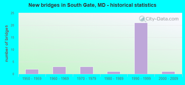
- New bridges - historical statistics
- 21950-1959
- 31960-1969
- 31970-1979
- 11980-1989
- 211990-1999
- 12000-2009


- Bridge Condition - Deck
- 76.9%Good
- 23.1%Satisfactory

- Bridge Condition - Superstructure
- 7.7%Very good
- 61.5%Good
- 30.8%Satisfactory

- Bridge Condition - Substructure
- 7.7%Very good
- 69.2%Good
- 23.1%Satisfactory

- Bridge Condition - Channel
- 25.0%Very good
- 50.0%Good
- 25.0%Satisfactory

- Bridge Condition - Culverts
- 50.0%Good
- 25.0%Satisfactory
- 25.0%Poor
Find on map >> Show street view
Structure Number: 10000002006301, Location: 0.24 MI W OF MD 779 (Lat: 39.144506, Lng: -76.645144), Route carried "on" structure: State highway 174, Year Built: 2004, Status: Open, Structure Length: 8.35m (27.40ft), Average Daily Traffic: 8,580 (year 2009), Truck Traffic: 8%, Average Future Daily Traffic: 10,204 (year 2026), Design Load: HS 25 or greater, Features Intersected: IS 97
Minimum Vertical Clearance: 30+ m (98+ ft), Kilometerpoint: 7.948, Lanes on structure: 6, Lanes under structure: 8, Owner: State Highway Agency, Approaching Roadway Width: 25.6m (84.0ft), Skew: 22 degrees, Material/Design: Steel continuous, Design/Construction: Stringer/Multi-beam, Number Of Spans In Main Unit: 2, Length of Maximum Span: 42.1m (138.1ft), Curb or Sidewalk Widths: Left: 1.6m (5.2ft), Right: 0.0m, Curb-To-Curb Width: 23.2m (76.1ft), Out-to-Out Width: 26.9m (88.3ft)
Condition: Deck: Good, Superstructure: Very good, Substructure: Very good, Inventory Rating: 59.9 metric tons, Method Used To Determine Inventory Rating: Load Factor (LF), Structural Evaluation: Equal to present desirable criteria, Deck Geometry: Meets minimum limits, Underclear: Equal to present minimum criteria, Approach Roadway Alignment: Equal to present desirable criteria, Designated Inspection Frequency: Every 24 months, Inspection Date: December 2020, Deck Structure Type: Concrete Cast-file-Place, Wearing Surface/Protective System: Wearing Surface: Integral Concrete, Deck Protection: Epoxy Coated Reinforcing
Find on map >> Show street view
Structure Number: 100000020065011, Location: 1.19 MILE SOUTH OF MD 174 (Lat: 39.127658, Lng: -76.640997), Route carried "on" structure: Interstate 97, Year Built: 1990, Status: Open, Structure Length: 7.80m (25.59ft), Average Daily Traffic: 135,900 (year 2009), Truck Traffic: 8%, Average Future Daily Traffic: 126,830 (year 2029), Design Load: HS 20+Mod, Features Intersected: MD 3 BUSINESS
Minimum Vertical Clearance: 30+ m (98+ ft), Kilometerpoint: 19.432, Lanes on structure: 3, Lanes under structure: 4, Base Highway Network: Yes, Owner: State Highway Agency, Approaching Roadway Width: 17.1m (56.1ft), Skew: 4 degrees, Material/Design: Steel continuous, Design/Construction: Stringer/Multi-beam, Number Of Spans In Main Unit: 2, Length of Maximum Span: 37.8m (124.0ft), Curb-To-Curb Width: 17.1m (56.1ft), Out-to-Out Width: 18.3m (60.0ft)
Condition: Deck: Good, Superstructure: Good, Substructure: Good, Operating Rating: 88.9 metric tons, Method Used To Determine Operating Rating: Load Factor (LF), Inventory Rating: 53.1 metric tons, Method Used To Determine Inventory Rating: Load Factor (LF), Structural Evaluation: Better than present minimum criteria, Deck Geometry: Equal to present minimum criteria, Underclear: Somewhat better than minimum adequacy, Approach Roadway Alignment: Equal to present desirable criteria, Designated Inspection Frequency: Every 24 months, Inspection Date: August 2020, Deck Structure Type: Concrete Cast-file-Place, Wearing Surface/Protective System: Wearing Surface: Monolithic Concrete, Deck Protection: Epoxy Coated Reinforcing
Find on map >> Show street view
Structure Number: 100000020065012, Location: 1.19 MILE SOUTH OF MD 174 (Lat: 39.127875, Lng: -76.641536), Route carried "on" structure: Interstate 97, Year Built: 1990, Status: Open, Structure Length: 7.80m (25.59ft), Average Daily Traffic: 135,900 (year 2009), Truck Traffic: 8%, Average Future Daily Traffic: 126,830 (year 2029), Design Load: HS 20+Mod, Features Intersected: MD 3 BUSINESS
Minimum Vertical Clearance: 30+ m (98+ ft), Kilometerpoint: 19.432, Lanes on structure: 4, Lanes under structure: 4, Base Highway Network: Yes, Owner: State Highway Agency, Approaching Roadway Width: 20.7m (67.9ft), Skew: 4 degrees, Material/Design: Steel continuous, Design/Construction: Stringer/Multi-beam, Number Of Spans In Main Unit: 2, Length of Maximum Span: 37.8m (124.0ft), Curb-To-Curb Width: 20.7m (67.9ft), Out-to-Out Width: 21.9m (71.9ft)
Condition: Deck: Good, Superstructure: Satisfactory, Substructure: Good, Operating Rating: 82.5 metric tons, Method Used To Determine Operating Rating: Load Factor (LF), Inventory Rating: 49.4 metric tons, Method Used To Determine Inventory Rating: Load Factor (LF), Structural Evaluation: Equal to present minimum criteria, Deck Geometry: Equal to present minimum criteria, Underclear: Somewhat better than minimum adequacy, Approach Roadway Alignment: Equal to present desirable criteria, Designated Inspection Frequency: Every 24 months, Inspection Date: August 2020, Deck Structure Type: Concrete Cast-file-Place, Wearing Surface/Protective System: Wearing Surface: Monolithic Concrete, Deck Protection: Epoxy Coated Reinforcing
Find on map >> Show street view
Structure Number: 100000020084013, Location: 0.54 MILE EAST OF MD 174 (Lat: 39.144567, Lng: -76.631819), Route carried "on" structure: State highway 100, Year Built: 1963, Status: Open, Structure Length: 6.43m (21.10ft), Average Daily Traffic: 75,406 (year 2009), Truck Traffic: 8%, Average Future Daily Traffic: 42,423 (year 2026), Design Load: HS 20, Features Intersected: MD 3 BUS
Minimum Vertical Clearance: 30+ m (98+ ft), Kilometerpoint: 12.129, Lanes on structure: 2, Lanes under structure: 4, Base Highway Network: Yes, Owner: State Highway Agency, Approaching Roadway Width: 12.2m (40.0ft), Skew: 3 degrees, Material/Design: Steel, Design/Construction: Stringer/Multi-beam, Number Of Spans In Main Unit: 4, Length of Maximum Span: 19.8m (65.0ft), Curb-To-Curb Width: 9.1m (29.9ft), Out-to-Out Width: 10.7m (35.1ft)
Condition: Deck: Satisfactory, Superstructure: Satisfactory, Substructure: Satisfactory, Operating Rating: 85.7 metric tons, Method Used To Determine Operating Rating: Load Factor (LF), Inventory Rating: 51.2 metric tons, Method Used To Determine Inventory Rating: Load Factor (LF), Structural Evaluation: Equal to present minimum criteria, Deck Geometry: Meets minimum limits, Underclear: Somewhat better than minimum adequacy, Approach Roadway Alignment: Equal to present desirable criteria, Length Of Structure Improvement: 6.43m (21.10ft), Designated Inspection Frequency: Every 24 months, Inspection Date: August 2020, Bridge Improvement Cost: $891,000, Roadway Improvement Cost: $89,000, Total Project Cost: $980,000, Deck Structure Type: Concrete Cast-file-Place, Wearing Surface/Protective System: Wearing Surface: Bituminous
Find on map >> Show street view
Structure Number: 10000002013901, Location: IS 97 INTER W/NEW CUT RD (Lat: 39.122147, Lng: -76.638214), Route carried "on" structure: Ramp Interstate 97, Year Built: 1989, Status: Open, Structure Length: 12.89m (42.29ft), Average Daily Traffic: 10,999 (year 1994), Truck Traffic: 8%, Average Future Daily Traffic: 12,979 (year 2012), Design Load: HS 20+Mod, Features Intersected: VETERANS HIGHWAY
Minimum Vertical Clearance: 15.18m (49.80ft), Kilometerpoint: 0.370, Lanes on structure: 1, Lanes under structure: 2, Base Highway Network: Yes, Owner: State Highway Agency, Approaching Roadway Width: 9.4m (30.8ft), Skew: 2 degrees, Material/Design: Steel continuous, Design/Construction: Stringer/Multi-beam, Number Of Spans In Main Unit: 3, Length of Maximum Span: 53.0m (173.9ft), Curb-To-Curb Width: 9.4m (30.8ft), Out-to-Out Width: 10.7m (35.1ft)
Condition: Deck: Satisfactory, Superstructure: Satisfactory, Substructure: Satisfactory, Operating Rating: 65.8 metric tons, Method Used To Determine Operating Rating: Load Factor (LF), Inventory Rating: 39.5 metric tons, Method Used To Determine Inventory Rating: Load Factor (LF), Structural Evaluation: Equal to present minimum criteria, Deck Geometry: Superior to present desirable criteria, Underclear: Equal to present minimum criteria, Approach Roadway Alignment: Equal to present desirable criteria, Designated Inspection Frequency: Every 24 months, Inspection Date: September 2021, Deck Structure Type: Concrete Cast-file-Place, Wearing Surface/Protective System: Wearing Surface: Monolithic Concrete, Deck Protection: Epoxy Coated Reinforcing
Find on map >> Show street view
Structure Number: 100000020193013, Location: I-97 MD 100 INTERCHANGE (Lat: 39.154006, Lng: -76.648983), Route carried "on" structure: State highway 100, Year Built: 1996, Status: Open, Structure Length: 3.38m (11.09ft), Average Daily Traffic: 34,826 (year 2006), Average Future Daily Traffic: 40,154 (year 2026), Design Load: HS 20, Features Intersected: MD 100 RAMP '2'
Minimum Vertical Clearance: 30+ m (98+ ft), Kilometerpoint: 9.981, Lanes on structure: 2, Lanes under structure: 2, Base Highway Network: Yes, Owner: State Highway Agency, Approaching Roadway Width: 11.6m (38.1ft), Skew: 4 degrees, Material/Design: Steel, Design/Construction: Stringer/Multi-beam, Number Of Spans In Main Unit: 1, Length of Maximum Span: 33.8m (110.9ft), Curb-To-Curb Width: 11.6m (38.1ft), Out-to-Out Width: 12.8m (42.0ft)
Condition: Deck: Good, Superstructure: Good, Substructure: Good, Inventory Rating: 71.7 metric tons, Method Used To Determine Inventory Rating: Load Factor (LF), Structural Evaluation: Better than present minimum criteria, Deck Geometry: Equal to present minimum criteria, Underclear: Equal to present desirable criteria, Approach Roadway Alignment: Equal to present desirable criteria, Designated Inspection Frequency: Every 24 months, Inspection Date: November 2020, Deck Structure Type: Concrete Cast-file-Place, Wearing Surface/Protective System: Wearing Surface: Monolithic Concrete, Deck Protection: Epoxy Coated Reinforcing
Find on map >> Show street view
Structure Number: 100000020193014, Location: I-97 MD 100 INTERCHANGE (Lat: 39.154050, Lng: -76.648658), Route carried "on" structure: State highway 100, Year Built: 1996, Status: Open, Structure Length: 3.38m (11.09ft), Average Daily Traffic: 34,826 (year 2006), Average Future Daily Traffic: 40,154 (year 2026), Design Load: HS 20, Features Intersected: MD 100 RAMP '2'
Minimum Vertical Clearance: 30+ m (98+ ft), Kilometerpoint: 9.981, Lanes on structure: 2, Lanes under structure: 2, Base Highway Network: Yes, Owner: State Highway Agency, Approaching Roadway Width: 11.6m (38.1ft), Skew: 4 degrees, Material/Design: Steel, Design/Construction: Stringer/Multi-beam, Number Of Spans In Main Unit: 1, Length of Maximum Span: 33.8m (110.9ft), Curb-To-Curb Width: 11.6m (38.1ft), Out-to-Out Width: 12.8m (42.0ft)
Condition: Deck: Good, Superstructure: Good, Substructure: Good, Inventory Rating: 72.1 metric tons, Method Used To Determine Inventory Rating: Load Factor (LF), Structural Evaluation: Better than present minimum criteria, Deck Geometry: Equal to present minimum criteria, Underclear: Equal to present desirable criteria, Approach Roadway Alignment: Equal to present desirable criteria, Designated Inspection Frequency: Every 24 months, Inspection Date: November 2020, Deck Structure Type: Concrete Cast-file-Place, Wearing Surface/Protective System: Wearing Surface: Monolithic Concrete, Deck Protection: Epoxy Coated Reinforcing
Find on map >> Show street view
Structure Number: 100000020195013, Location: I-97 MD 100 INTERCHANGE (Lat: 39.152528, Lng: -76.643239), Route carried "on" structure: State highway 100, Year Built: 1996, Status: Open, Structure Length: 2.99m (9.81ft), Average Daily Traffic: 75,406 (year 2009), Average Future Daily Traffic: 42,423 (year 2026), Design Load: HS 20, Features Intersected: IS 97 RAMP 1 'A'
Minimum Vertical Clearance: 30+ m (98+ ft), Kilometerpoint: 10.536, Lanes on structure: 4, Lanes under structure: 2, Base Highway Network: Yes, Owner: State Highway Agency, Approaching Roadway Width: 21.6m (70.9ft), Material/Design: Steel, Design/Construction: Stringer/Multi-beam, Number Of Spans In Main Unit: 1, Length of Maximum Span: 29.9m (98.1ft), Curb-To-Curb Width: 21.6m (70.9ft), Out-to-Out Width: 23.4m (76.8ft)
Condition: Deck: Good, Superstructure: Good, Substructure: Good, Inventory Rating: 62.1 metric tons, Method Used To Determine Inventory Rating: Load Factor (LF), Structural Evaluation: Better than present minimum criteria, Deck Geometry: Better than present minimum criteria, Underclear: Equal to present desirable criteria, Approach Roadway Alignment: Equal to present desirable criteria, Designated Inspection Frequency: Every 24 months, Inspection Date: November 2020, Deck Structure Type: Concrete Cast-file-Place, Wearing Surface/Protective System: Wearing Surface: Monolithic Concrete, Deck Protection: Epoxy Coated Reinforcing
Find on map >> Show street view
Structure Number: 100000020195014, Location: I-97 MD 100 INTERCHANGE (Lat: 39.152819, Lng: -76.643053), Route carried "on" structure: State highway 100, Year Built: 1996, Status: Open, Structure Length: 2.99m (9.81ft), Average Daily Traffic: 75,406 (year 2009), Average Future Daily Traffic: 42,423 (year 2026), Design Load: HS 20, Features Intersected: IS 97 RAMP 1 'A'
Minimum Vertical Clearance: 30+ m (98+ ft), Kilometerpoint: 10.536, Lanes on structure: 2, Lanes under structure: 2, Base Highway Network: Yes, Owner: State Highway Agency, Approaching Roadway Width: 11.6m (38.1ft), Material/Design: Steel, Design/Construction: Stringer/Multi-beam, Number Of Spans In Main Unit: 1, Length of Maximum Span: 29.9m (98.1ft), Curb-To-Curb Width: 12.8m (42.0ft), Out-to-Out Width: 13.1m (43.0ft)
Condition: Deck: Good, Superstructure: Good, Substructure: Good, Inventory Rating: 63.9 metric tons, Method Used To Determine Inventory Rating: Load Factor (LF), Structural Evaluation: Better than present minimum criteria, Deck Geometry: Equal to present desirable criteria, Underclear: Equal to present desirable criteria, Approach Roadway Alignment: Equal to present desirable criteria, Designated Inspection Frequency: Every 24 months, Inspection Date: November 2020, Deck Structure Type: Concrete Cast-file-Place, Wearing Surface/Protective System: Wearing Surface: Monolithic Concrete, Deck Protection: Epoxy Coated Reinforcing
Find on map >> Show street view
Structure Number: 10000002019601, Location: IS 97 SB TO MD 100 EB (Lat: 39.155139, Lng: -76.647922), Route carried "on" structure: Ramp State highway 100, Year Built: 1996, Status: Open, Structure Length: 3.44m (11.29ft), Average Daily Traffic: 43,587 (year 1996), Average Future Daily Traffic: 50,256 (year 2016), Design Load: HS 20+Mod, Features Intersected: MD 100 RAMP 'A'
Minimum Vertical Clearance: 30+ m (98+ ft), Kilometerpoint: 10.024, Lanes on structure: 2, Lanes under structure: 2, Base Highway Network: Yes, Owner: State Highway Agency, Approaching Roadway Width: 11.9m (39.0ft), Skew: 2 degrees, Material/Design: Steel, Design/Construction: Stringer/Multi-beam, Number Of Spans In Main Unit: 1, Length of Maximum Span: 32.9m (107.9ft), Curb-To-Curb Width: 11.9m (39.0ft), Out-to-Out Width: 13.1m (43.0ft)
Condition: Deck: Good, Superstructure: Good, Substructure: Good, Operating Rating: 74.4 metric tons, Method Used To Determine Operating Rating: Load Factor (LF), Inventory Rating: 44.4 metric tons, Method Used To Determine Inventory Rating: Load Factor (LF), Structural Evaluation: Better than present minimum criteria, Deck Geometry: Superior to present desirable criteria, Underclear: Equal to present desirable criteria, Approach Roadway Alignment: Equal to present desirable criteria, Designated Inspection Frequency: Every 24 months, Inspection Date: November 2020, Deck Structure Type: Concrete Cast-file-Place, Wearing Surface/Protective System: Wearing Surface: Integral Concrete, Deck Protection: Epoxy Coated Reinforcing
Find on map >> Show street view
Structure Number: 10000002019701, Location: 0.14 MILE NORTH OF MD 100 (Lat: 39.154742, Lng: -76.646097), Route carried "on" structure: Ramp Interstate 97, Year Built: 1996, Status: Open, Structure Length: 9.48m (31.10ft), Average Daily Traffic: 43,587 (year 1996), Average Future Daily Traffic: 50,256 (year 2016), Design Load: HS 20+Mod, Features Intersected: IS 97
Minimum Vertical Clearance: 30+ m (98+ ft), Kilometerpoint: 0.949, Lanes on structure: 2, Lanes under structure: 7, Base Highway Network: Yes, Owner: State Highway Agency, Approaching Roadway Width: 11.9m (39.0ft), Skew: 3 degrees, Material/Design: Steel continuous, Design/Construction: Stringer/Multi-beam, Number Of Spans In Main Unit: 2, Length of Maximum Span: 48.2m (158.1ft), Curb-To-Curb Width: 11.9m (39.0ft), Out-to-Out Width: 13.1m (43.0ft)
Condition: Deck: Good, Superstructure: Good, Substructure: Good, Inventory Rating: 58.0 metric tons, Method Used To Determine Inventory Rating: Load Factor (LF), Structural Evaluation: Better than present minimum criteria, Deck Geometry: Superior to present desirable criteria, Underclear: Somewhat better than minimum adequacy, Approach Roadway Alignment: Equal to present desirable criteria, Designated Inspection Frequency: Every 24 months, Inspection Date: June 2021, Deck Structure Type: Concrete Cast-file-Place, Wearing Surface/Protective System: Wearing Surface: Integral Concrete, Deck Protection: Epoxy Coated Reinforcing
Find on map >> Show street view
Structure Number: 10000002019801, Location: 0.03 MILE SOUTH OF MD 100 (Lat: 39.152100, Lng: -76.645847), Route carried "on" structure: Ramp Interstate 97, Year Built: 1996, Status: Open, Structure Length: 7.77m (25.49ft), Average Daily Traffic: 43,587 (year 1996), Average Future Daily Traffic: 50,256 (year 2016), Design Load: HS 20+Mod, Features Intersected: IS 97
Minimum Vertical Clearance: 30+ m (98+ ft), Kilometerpoint: 1.255, Lanes on structure: 3, Lanes under structure: 6, Base Highway Network: Yes, Owner: State Highway Agency, Approaching Roadway Width: 20.7m (67.9ft), Skew: 30 degrees, Material/Design: Steel continuous, Design/Construction: Stringer/Multi-beam, Number Of Spans In Main Unit: 2, Length of Maximum Span: 40.2m (131.9ft), Curb-To-Curb Width: 20.1m (65.9ft), Out-to-Out Width: 23.0m (75.5ft)
Condition: Deck: Good, Superstructure: Good, Substructure: Satisfactory, Operating Rating: 74.4 metric tons, Method Used To Determine Operating Rating: Load Factor (LF), Inventory Rating: 44.9 metric tons, Method Used To Determine Inventory Rating: Load Factor (LF), Structural Evaluation: Equal to present minimum criteria, Deck Geometry: Superior to present desirable criteria, Underclear: Equal to present minimum criteria, Approach Roadway Alignment: Equal to present desirable criteria, Designated Inspection Frequency: Every 24 months, Inspection Date: January 2021, Deck Structure Type: Concrete Cast-file-Place, Wearing Surface/Protective System: Wearing Surface: Integral Concrete, Deck Protection: Epoxy Coated Reinforcing
Find on map >> Show street view
Structure Number: 200000AA201403, Location: 0.4 MI. E. OF OAKWOOD RD (Lat: 39.137033, Lng: -76.611622), Route carried "on" structure: County highway , Year Built: 1991, Status: Open, Structure Length: 0.76m (2.49ft), Average Daily Traffic: 4,097 (year 2019), Truck Traffic: 5%, Average Future Daily Traffic: 4,400 (year 2045), Features Intersected: MARLEY CREEK, Facility Carried by Structure: HOSPITAL DRIVE
Minimum Vertical Clearance: 30+ m (98+ ft), Kilometerpoint: 0.000, Lanes on structure: 3, Owner: County Highway Agency, Approaching Roadway Width: 15.2m (49.9ft), Skew: 2 degrees, Material/Design: Steel, Design/Construction: Culvert, Length of Maximum Span: 2.4m (7.9ft), Curb or Sidewalk Widths: Left: 1.6m (5.2ft), Right: 1.6m (5.2ft)
Condition: Channel: Good, Culverts: Poor, Structural Evaluation: Meets minimum limits, Waterway Adequacy: Equal to present desirable criteria, Approach Roadway Alignment: Equal to present desirable criteria, Length Of Structure Improvement: 7.62m (25.00ft), Designated Inspection Frequency: Every 24 months, Inspection Date: March 2020, Bridge Improvement Cost: $50,000, Roadway Improvement Cost: $6,000, Total Project Cost: $60,000 ( Estimate for 2018)
Find on map >> Show street view
Structure Number: 200000AA300803, Location: 0.80 MI S OF MD 100 (Lat: 39.127008, Lng: -76.624036), Route carried "on" structure: County highway , Year Built: 1975, Status: Open, Structure Length: 0.85m (2.79ft), Average Daily Traffic: 2,819 (year 2019), Truck Traffic: 2%, Average Future Daily Traffic: 3,200 (year 2045), Features Intersected: TRIBUTARY TO MARLEY CREE, Facility Carried by Structure: SHETLANDS LANE
Minimum Vertical Clearance: 30+ m (98+ ft), Kilometerpoint: 0.000, Lanes on structure: 2, Owner: County Highway Agency, Approaching Roadway Width: 12.2m (40.0ft), Material/Design: Steel, Design/Construction: Culvert, Length of Maximum Span: 2.4m (7.9ft), Curb or Sidewalk Widths: Left: 0.0m, Right: 1.2m (3.9ft)
Condition: Channel: Good, Culverts: Good, Inventory Rating: 68.9 metric tons, Method Used To Determine Inventory Rating: Load Factor (LF), Structural Evaluation: Better than present minimum criteria, Waterway Adequacy: Better than present minimum criteria, Approach Roadway Alignment: Equal to present minimum criteria, Designated Inspection Frequency: Every 24 months, Inspection Date: March 2020, Bridge Improvement Cost: $11,000, Roadway Improvement Cost: $2,000, Total Project Cost: $13,000 ( Estimate for 2016)
Find on map >> Show street view
Structure Number: 200000AA301103, Location: 253 Ft. S of Nolpark Dr, (Lat: 39.218211, Lng: -77.060736), Route carried "on" structure: County highway , Year Built: 1978, Status: Open, Structure Length: 0.78m (2.56ft), Average Daily Traffic: 2,406 (year 2016), Truck Traffic: 5%, Average Future Daily Traffic: 3,440 (year 2036), Design Load: HS 20, Features Intersected: MARLEY CREEK, Facility Carried by Structure: PHIRNE ROAD EAST
Minimum Vertical Clearance: 30+ m (98+ ft), Kilometerpoint: 0.724, Lanes on structure: 2, Owner: County Highway Agency, Approaching Roadway Width: 12.2m (40.0ft), Skew: 1 degrees, Material/Design: Steel, Design/Construction: Culvert, Length of Maximum Span: 7.6m (24.9ft), Curb or Sidewalk Widths: Left: 2.7m (8.9ft), Right: 2.7m (8.9ft), Curb-To-Curb Width: 12.3m (40.4ft), Out-to-Out Width: 31.4m (103.0ft)
Condition: Channel: Satisfactory, Culverts: Satisfactory, Structural Evaluation: Equal to present minimum criteria, Deck Geometry: Equal to present minimum criteria, Waterway Adequacy: Better than present minimum criteria, Approach Roadway Alignment: Equal to present desirable criteria, Length Of Structure Improvement: 0.79m (2.59ft), Designated Inspection Frequency: Every 24 months, Inspection Date: March 2021, Bridge Improvement Cost: $10,000, Total Project Cost: $10,000 ( Estimate for 2017)
Find on map >> Show street view
Structure Number: 200000AA301503, Location: 0.6 MI S OF MD100 (Lat: 39.131483, Lng: -76.622972), Route carried "on" structure: County highway , Year Built: 1971, Status: Open, Structure Length: 0.77m (2.53ft), Average Daily Traffic: 652 (year 2019), Truck Traffic: 1%, Average Future Daily Traffic: 700 (year 2045), Features Intersected: MARLEY CREEK, Facility Carried by Structure: STARWOOD DRIVE
Minimum Vertical Clearance: 30+ m (98+ ft), Kilometerpoint: 0.000, Lanes on structure: 2, Owner: County Highway Agency, Approaching Roadway Width: 7.3m (24.0ft), Material/Design: Aluminum, Iron, Design/Construction: Culvert, Length of Maximum Span: 2.4m (7.9ft), Curb-To-Curb Width: 7.3m (24.0ft), Out-to-Out Width: 7.3m (24.0ft)
Condition: Channel: Very good, Culverts: Good, Structural Evaluation: Better than present minimum criteria, Deck Geometry: Meets minimum limits, Waterway Adequacy: Superior to present desirable criteria, Approach Roadway Alignment: Equal to present minimum criteria, Designated Inspection Frequency: Every 24 months, Inspection Date: June 2021, Wearing Surface/Protective System: Wearing Surface: Bituminous
Find on map >> Show street view
Structure Number: 300000AAY04501, Location: Milepost 4.5 (Lat: 39.117992, Lng: -76.624661), Route carried "on" structure: Ramp Interstate 895, Year Built: 1957, Status: Open, Structure Length: 6.86m (22.51ft), Average Daily Traffic: 13,017 (year 2019), Truck Traffic: 8%, Average Future Daily Traffic: 16,559 (year 2041), Design Load: HS 20, Features Intersected: I 895
Minimum Vertical Clearance: 30+ m (98+ ft), Kilometerpoint: 7.241, Lanes on structure: 1, Lanes under structure: 4, Base Highway Network: Yes, Toll: On toll road, Owner: State Toll Authority, Approaching Roadway Width: 6.7m (22.0ft), Skew: 9 degrees, Material/Design: Steel, Design/Construction: Stringer/Multi-beam, Number Of Spans In Main Unit: 4, Length of Maximum Span: 25.0m (82.0ft), Curb-To-Curb Width: 6.7m (22.0ft), Out-to-Out Width: 8.0m (26.2ft)
Condition: Deck: Satisfactory, Superstructure: Satisfactory, Substructure: Good, Operating Rating: 64.9 metric tons, Method Used To Determine Operating Rating: Load Factor (LF), Inventory Rating: 38.5 metric tons, Method Used To Determine Inventory Rating: Load Factor (LF), Structural Evaluation: Equal to present minimum criteria, Deck Geometry: Equal to present minimum criteria, Underclear: High priority of replacement, Approach Roadway Alignment: Equal to present desirable criteria, Length Of Structure Improvement: 8.02m (26.31ft), Designated Inspection Frequency: Every 24 months, Inspection Date: January 2020, Bridge Improvement Cost: $827,000, Roadway Improvement Cost: $83,000, Total Project Cost: $910,000, Deck Structure Type: Concrete Cast-file-Place, Wearing Surface/Protective System: Wearing Surface: Latex Concrete
Find on map >> Show street view
Structure Number: 10000002006301, Location: 0.24 MI W OF MD 779 (Lat: 39.144506, Lng: -76.645144), Route carried "under" structure: Interstate 97, Year Built: 1955, Structure Length: 0. m, Average Daily Traffic: 122,490 (year 2009), Features Intersected: IS 97, Facility Carried by Structure: MD 174
Minimum Vertical Clearance: 4.88m (16.01ft), Kilometerpoint: 21.384, Lanes on structure: 2, Lanes under structure: 4, Material/Design: Steel continuous, Design/Construction: Stringer/Multi-beam, Length of Maximum Span: 24.1m (79.1ft)
Find on map >> Show street view
Structure Number: 100000020065011, Location: .19 MILE NORTH OF MD 997E (Lat: 39.127658, Lng: -76.640997), Route carried "under" structure: State highway 3, Year Built: 1990, Structure Length: 0. m, Average Daily Traffic: 29,470 (year 2009), Truck Traffic: 8%, Features Intersected: MD 3 BUS, Facility Carried by Structure: IS 97 NBR
Minimum Vertical Clearance: 5.18m (16.99ft), Kilometerpoint: 0.869, Lanes on structure: 3, Lanes under structure: 4, Material/Design: Steel continuous, Design/Construction: Stringer/Multi-beam, Length of Maximum Span: 37.8m (124.0ft)
Find on map >> Show street view
Structure Number: 100000020065012, Location: .19 MILE NORTH OF MD 997E (Lat: 39.127875, Lng: -76.641536), Route carried "under" structure: State highway 3, Year Built: 1990, Structure Length: 0. m, Average Daily Traffic: 29,470 (year 2009), Truck Traffic: 8%, Features Intersected: MD 3 BUS, Facility Carried by Structure: IS 97 SBR
Minimum Vertical Clearance: 5.18m (16.99ft), Kilometerpoint: 0.869, Lanes on structure: 4, Lanes under structure: 4, Material/Design: Steel continuous, Design/Construction: Stringer/Multi-beam, Length of Maximum Span: 37.8m (124.0ft)
Find on map >> Show street view
Structure Number: 100000020083013, Location: 0.69 MILE EAST OF IS 97 (Lat: 39.151500, Lng: -76.635778), Route carried "under" structure: State highway 174, Year Built: 1963, Structure Length: 0. m, Average Daily Traffic: 8,580 (year 2009), Features Intersected: MD 174, Facility Carried by Structure: MD 100 EBR
Minimum Vertical Clearance: 4.88m (16.01ft), Kilometerpoint: 9.059, Lanes on structure: 2, Lanes under structure: 4, Material/Design: Steel, Design/Construction: Stringer/Multi-beam, Length of Maximum Span: 13.1m (43.0ft)
Find on map >> Show street view
Structure Number: 100000020084013, Location: 0.68 MILE SOUTH OF MD 174 (Lat: 39.144567, Lng: -76.631819), Route carried "under" structure: State highway 3, Year Built: 1963, Structure Length: 0. m, Average Daily Traffic: 22,340 (year 2009), Features Intersected: MD 3 BUS, Facility Carried by Structure: MD 100 EBR
Minimum Vertical Clearance: 4.88m (16.01ft), Kilometerpoint: 2.977, Lanes on structure: 2, Lanes under structure: 4, Material/Design: Steel, Design/Construction: Stringer/Multi-beam, Length of Maximum Span: 19.8m (65.0ft)
Find on map >> Show street view
Structure Number: 100000020193013, Location: 0.12 MILE WEST OF IS 97 (Lat: 39.154006, Lng: -76.648983), Route carried "under" structure: Ramp State highway 97, Year Built: 1996, Structure Length: 0. m, Average Daily Traffic: 8,391 (year 2012), Truck Traffic: 8%, Features Intersected: IS 97 RAMP '2', Facility Carried by Structure: MD 100 EBR
Minimum Vertical Clearance: 5.18m (16.99ft), Kilometerpoint: 0.798, Lanes on structure: 2, Lanes under structure: 2, Material/Design: Steel, Design/Construction: Stringer/Multi-beam, Length of Maximum Span: 33.8m (110.9ft)
Find on map >> Show street view
Structure Number: 100000020193014, Location: 0.12 MILE WEST OF IS 97 (Lat: 39.154050, Lng: -76.648658), Route carried "under" structure: Ramp State highway 97, Year Built: 1996, Structure Length: 0. m, Average Daily Traffic: 8,391 (year 2012), Truck Traffic: 8%, Features Intersected: IS 97 RAMP '2', Facility Carried by Structure: MD 100 WBR
Minimum Vertical Clearance: 5.18m (16.99ft), Kilometerpoint: 0.798, Lanes on structure: 2, Lanes under structure: 2, Material/Design: Steel, Design/Construction: Stringer/Multi-beam, Length of Maximum Span: 33.8m (110.9ft)
Find on map >> Show street view
Structure Number: 100000020194013, Location: 0.03 M N OF BR NO 0219800 (Lat: 39.152472, Lng: -76.645881), Route carried "under" structure: Interstate 97, Year Built: 1996, Structure Length: 0. m, Average Daily Traffic: 126,070 (year 2006), Truck Traffic: 8%, Features Intersected: IS 97, Facility Carried by Structure: MD 100 EBR
Minimum Vertical Clearance: 5.49m (18.01ft), Kilometerpoint: 22.269, Lanes on structure: 2, Lanes under structure: 3, Material/Design: Steel continuous, Design/Construction: Stringer/Multi-beam, Length of Maximum Span: 41.5m (136.2ft)
Find on map >> Show street view
Structure Number: 100000020194014, Location: 0.03 M N OF BR NO 0219800 (Lat: 39.152600, Lng: -76.645019), Route carried "under" structure: Interstate 97, Year Built: 1996, Structure Length: 0. m, Average Daily Traffic: 126,070 (year 2006), Truck Traffic: 8%, Features Intersected: IS 97, Facility Carried by Structure: MD 100 WBR
Minimum Vertical Clearance: 5.49m (18.01ft), Kilometerpoint: 22.269, Lanes on structure: 2, Lanes under structure: 3, Material/Design: Steel continuous, Design/Construction: Stringer/Multi-beam, Length of Maximum Span: 41.5m (136.2ft)
Find on map >> Show street view
Structure Number: 100000020195013, Location: 0.13 MILE EAST OF IS 97 (Lat: 39.152528, Lng: -76.643239), Route carried "under" structure: Ramp State highway 97, Year Built: 1996, Structure Length: 0. m, Average Daily Traffic: 12,680 (year 2012), Truck Traffic: 8%, Features Intersected: IS 97 RAMP 1 'A', Facility Carried by Structure: MD 100 EBR
Minimum Vertical Clearance: 5.18m (16.99ft), Kilometerpoint: 0.586, Lanes on structure: 2, Lanes under structure: 1, Material/Design: Steel, Design/Construction: Stringer/Multi-beam, Length of Maximum Span: 29.9m (98.1ft)
Find on map >> Show street view
Structure Number: 100000020195014, Location: 0.13 MILE EAST OF IS 97 (Lat: 39.152819, Lng: -76.643053), Route carried "under" structure: Ramp State highway 97, Year Built: 1996, Structure Length: 0. m, Average Daily Traffic: 12,680 (year 2012), Truck Traffic: 8%, Features Intersected: IS 97 RAMP 1 'A', Facility Carried by Structure: MD 100 WBR
Minimum Vertical Clearance: 5.18m (16.99ft), Kilometerpoint: 0.619, Lanes on structure: 2, Lanes under structure: 1, Material/Design: Steel, Design/Construction: Stringer/Multi-beam, Length of Maximum Span: 29.9m (98.1ft)
Find on map >> Show street view
Structure Number: 10000002019601, Location: IS 97 SB TO MD 100 EB (Lat: 39.155139, Lng: -76.647922), Route carried "under" structure: Ramp State highway 100, Year Built: 1996, Structure Length: 0. m, Average Daily Traffic: 64,763 (year 2003), Truck Traffic: 8%, Features Intersected: MD 100 RAMP 'A'
Minimum Vertical Clearance: 5.49m (18.01ft), Kilometerpoint: 10.330, Lanes on structure: 2, Lanes under structure: 2, Material/Design: Steel, Design/Construction: Stringer/Multi-beam, Length of Maximum Span: 32.9m (107.9ft)
Find on map >> Show street view
Structure Number: 10000002019701, Location: 0.14 MILE NORTH OF MD 100 (Lat: 39.154742, Lng: -76.646097), Route carried "under" structure: Interstate 97, Year Built: 1996, Structure Length: 0. m, Average Daily Traffic: 119,260 (year 2009), Features Intersected: IS 97
Minimum Vertical Clearance: 4.88m (16.01ft), Kilometerpoint: 22.494, Lanes on structure: 2, Lanes under structure: 7, Material/Design: Steel continuous, Design/Construction: Stringer/Multi-beam, Length of Maximum Span: 48.2m (158.1ft)
Find on map >> Show street view
Structure Number: 10000002019801, Location: 0.03 MILE SOUTH OF MD 100 (Lat: 39.152100, Lng: -76.645847), Route carried "under" structure: Interstate 97, Year Built: 1996, Structure Length: 0. m, Average Daily Traffic: 122,490 (year 2009), Features Intersected: IS 97
Minimum Vertical Clearance: 5.79m (19.00ft), Kilometerpoint: 22.220, Lanes on structure: 2, Lanes under structure: 6, Material/Design: Steel continuous, Design/Construction: Stringer/Multi-beam, Length of Maximum Span: 40.2m (131.9ft)