Bridge Statistics for South Gate, California (CA)
Condition, Traffic, Stress, Structural Evaluation, Project Costs
- National Bridge Inventory (NBI) Statistics
- 15Number of bridges
- 292ft / 88.6mTotal length
- 1,465,945Total average daily traffic
- 140,977Total average daily truck traffic
- National Bridge Inventory (NBI) Registered Bridges for South Gate
- No street view available for this location
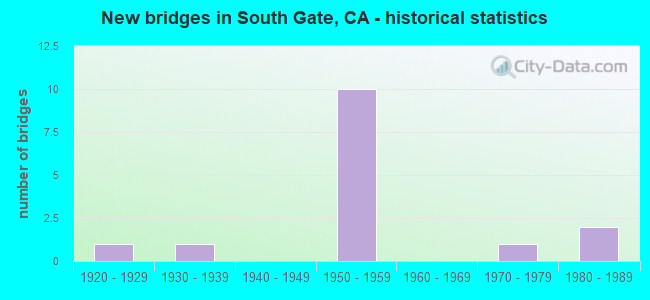
- New bridges - historical statistics
- 11920-1929
- 11930-1939
- 101950-1959
- 11970-1979
- 21980-1989

- Reconstructed bridges - Historical Statistics
- 11960-1969
- 11970-1979


- Bridge Condition - Deck
- 70.0%Good
- 20.0%Fair
- 10.0%Poor

- Bridge Condition - Superstructure
- 80.0%Good
- 10.0%Satisfactory
- 10.0%Fair

- Bridge Condition - Substructure
- 90.0%Good
- 10.0%Fair
Find on map >> Show street view
Structure Number: 53 0828, Location: 07-LA-710-17.34-SGT (Lat: 33.935025, Lng: -118.176014), Route carried "on" structure: Interstate 710, Year Built: 1955, Year Reconstructed: 1965, Status: Open, Structure Length: 17.50m (57.41ft), Average Daily Traffic: 220,000 (year 2017), Truck Traffic: 14%, Average Future Daily Traffic: 234,092 (year 2037), Design Load: HS 20, Features Intersected: LOS ANGELES RIVER
Minimum Vertical Clearance: 30+ m (98+ ft), Kilometerpoint: 17.340, Lanes on structure: 8, Base Highway Network: Yes (Inventory Route: 7, Subroute: 1), Owner: State Highway Agency, Approaching Roadway Width: 34.7m (113.8ft), Skew: 34 degrees, Material/Design: Steel continuous, Design/Construction: Stringer/Multi-beam, Number Of Spans In Main Unit: 4, Length of Maximum Span: 45.7m (149.9ft), Curb-To-Curb Width: 34.7m (113.8ft), Out-to-Out Width: 36.6m (120.1ft)
Condition: Deck: Poor, Superstructure: Good, Substructure: Good, Channel: Very good, Operating Rating: 70.6 metric tons, Method Used To Determine Operating Rating: Load Factor (LF), Inventory Rating: 42.1 metric tons, Method Used To Determine Inventory Rating: Load Factor (LF), Structural Evaluation: Better than present minimum criteria, Deck Geometry: Equal to present minimum criteria, Waterway Adequacy: Equal to present desirable criteria, Approach Roadway Alignment: Superior to present desirable criteria, Designated Inspection Frequency: Every 24 months, Critical Feature Inspection Frequency: Every 24 months, Other Special Inspection Frequency: Every 48 months, Inspection Date: May 2020, Critical Feature Inspection Date: December 2021, Other Special Inspection Date: December 2021, Deck Structure Type: Concrete Cast-file-Place
Find on map >> Show street view
Structure Number: 53 0829, Location: 07-LA-710-17.58-SGT (Lat: 33.937378, Lng: -118.172831), Route carried "on" structure: Interstate 710, Year Built: 1957, Status: Open, Structure Length: 1.46m (4.79ft), Average Daily Traffic: 223,000 (year 2017), Truck Traffic: 14%, Average Future Daily Traffic: 234,092 (year 2037), Design Load: HS 20, Features Intersected: UP RR
Minimum Vertical Clearance: 30+ m (98+ ft), Kilometerpoint: 17.580, Lanes on structure: 8, Base Highway Network: Yes (Inventory Route: 7, Subroute: 1), Owner: State Highway Agency, Approaching Roadway Width: 39.0m (128.0ft), Skew: 5 degrees, Material/Design: Concrete, Design/Construction: Slab, Number Of Spans In Main Unit: 1, Length of Maximum Span: 11.0m (36.1ft), Curb-To-Curb Width: 39.0m (128.0ft), Out-to-Out Width: 55.5m (182.1ft)
Condition: Deck: Good, Superstructure: Good, Substructure: Good, Operating Rating: 99.8 metric tons, Method Used To Determine Operating Rating: Load Factor (LF), Inventory Rating: 99.8 metric tons, Method Used To Determine Inventory Rating: Load Factor (LF), Structural Evaluation: Better than present minimum criteria, Deck Geometry: Superior to present desirable criteria, Underclear: Meets minimum limits, Approach Roadway Alignment: Meets minimum limits, Designated Inspection Frequency: Every 24 months, Inspection Date: May 2020
Find on map >> Show street view
Structure Number: 53 0831, Location: 07-LA-710-18.44-SGT (Lat: 33.949672, Lng: -118.170808), Route carried "on" structure: City street , Year Built: 1957, Status: Open, Structure Length: 6.98m (22.90ft), Average Daily Traffic: 43,030 (year 2011), Truck Traffic: 6%, Average Future Daily Traffic: 56,000 (year 2037), Design Load: HS 20, Features Intersected: INTERSTATE 710, Facility Carried by Structure: FIRESTONE BLVD
Minimum Vertical Clearance: 30+ m (98+ ft), Kilometerpoint: 0.000, Lanes on structure: 6, Lanes under structure: 10, Base Highway Network: Yes, Owner: State Highway Agency, Maintenance Responsibility: City or Municipal Highway Agency, Approaching Roadway Width: 25.6m (84.0ft), Skew: 21 degrees, Material/Design: Concrete continuous, Design/Construction: Tee Beam, Number Of Spans In Main Unit: 4, Length of Maximum Span: 21.0m (68.9ft), Curb or Sidewalk Widths: Left: 1.5m (4.9ft), Right: 1.5m (4.9ft), Curb-To-Curb Width: 25.6m (84.0ft), Out-to-Out Width: 29.3m (96.1ft)
Condition: Deck: Good, Superstructure: Good, Substructure: Good, Operating Rating: 24.9 metric tons, Method Used To Determine Operating Rating: Load and Resistance Factor Rating (LRFR) rating reported by rating factor(RF) method using HL-93 loadings, Inventory Rating: 19.4 metric tons, Method Used To Determine Inventory Rating: Load and Resistance Factor Rating (LRFR) rating reported by rating factor(RF) method using HL-93 loadings, Structural Evaluation: Meets minimum limits, Deck Geometry: Somewhat better than minimum adequacy, Underclear: High priority of corrective action, Approach Roadway Alignment: Equal to present desirable criteria, Designated Inspection Frequency: Every 24 months, Inspection Date: May 2020, Deck Structure Type: Concrete Cast-file-Place
Find on map >> Show street view
Structure Number: 53 2425, Location: 07-LA-105-R14.65-SGT (Lat: 33.911533, Lng: -118.159967), Route carried "on" structure: Business City street , Year Built: 1989, Status: Open, Structure Length: 9.05m (29.69ft), Average Daily Traffic: 30,775 (year 2016), Truck Traffic: 1%, Average Future Daily Traffic: 35,000 (year 2041), Design Load: HS 20+Mod, Features Intersected: ROUTE 105, LRT, Facility Carried by Structure: PARAMOUNT BLVD OC
Minimum Vertical Clearance: 30+ m (98+ ft), Kilometerpoint: 14.650, Lanes on structure: 6, Lanes under structure: 10, Owner: State Highway Agency, Approaching Roadway Width: 23.2m (76.1ft), Skew: 2 degrees, Material/Design: Prestressed concrete continuous, Design/Construction: Box Beam or Girders - Multiple, Number Of Spans In Main Unit: 2, Length of Maximum Span: 45.4m (149.0ft), Curb or Sidewalk Widths: Left: 1.5m (4.9ft), Right: 1.5m (4.9ft), Curb-To-Curb Width: 23.2m (76.1ft), Out-to-Out Width: 26.8m (87.9ft)
Condition: Deck: Good, Superstructure: Fair, Substructure: Good, Operating Rating: 54.1 metric tons, Method Used To Determine Operating Rating: Assigned rating based on Load Factor Design (LFD) reported in metric tons, Inventory Rating: 32.4 metric tons, Method Used To Determine Inventory Rating: Assigned rating based on Load Factor Design (LFD) reported in metric tons, Structural Evaluation: Somewhat better than minimum adequacy, Deck Geometry: Meets minimum limits, Underclear: High priority of corrective action, Approach Roadway Alignment: Equal to present desirable criteria, Designated Inspection Frequency: Every 24 months, Inspection Date: July 2020, Deck Structure Type: Concrete Cast-file-Place
Find on map >> Show street view
Structure Number: 53C0161, Location: 0.1 W/O ST GEORGE ST (Lat: 34.105419, Lng: -118.279981), Route carried "on" structure: City street , Year Built: 1925, Status: Open, Structure Length: 7.96m (26.12ft), Average Daily Traffic: 23,800 (year 2016), Truck Traffic: 1%, Average Future Daily Traffic: 26,524 (year 2038), Design Load: HS 20, Features Intersected: GARDEN, Facility Carried by Structure: FRANKLIN AVE
Minimum Vertical Clearance: 30+ m (98+ ft), Kilometerpoint: 0.000, Lanes on structure: 2, Owner: City or Municipal Highway Agency, Approaching Roadway Width: 7.6m (24.9ft), Material/Design: Concrete continuous, Design/Construction: Arch - Deck, Number Of Spans In Main Unit: 3, Number Of Approach Spans: 4, Length of Maximum Span: 24.4m (80.1ft), Curb or Sidewalk Widths: Left: 0.5m (1.6ft), Right: 1.2m (3.9ft), Curb-To-Curb Width: 6.4m (21.0ft), Out-to-Out Width: 8.6m (28.2ft)
Condition: Deck: Fair, Superstructure: Good, Substructure: Good, Operating Rating: 60.3 metric tons, Method Used To Determine Operating Rating: Load Factor (LF), Inventory Rating: 36.0 metric tons, Method Used To Determine Inventory Rating: Load Factor (LF), Structural Evaluation: Better than present minimum criteria, Deck Geometry: High priority of replacement, Approach Roadway Alignment: Better than present minimum criteria, Designated Inspection Frequency: Every 24 months, Inspection Date: May 2020, Deck Structure Type: Concrete Cast-file-Place
Find on map >> Show street view
Structure Number: 53C0166, Location: 300FT E/O GARFIELD AVE (Lat: 33.944306, Lng: -118.165364), Route carried "on" structure: City street L146, Year Built: 1951, Year Reconstructed: 1978, Status: Open, Structure Length: 7.01m (23.00ft), Average Daily Traffic: 15,141 (year 2014), Truck Traffic: 1%, Average Future Daily Traffic: 18,169 (year 2042), Design Load: HS 20, Features Intersected: RIO HONDO, Facility Carried by Structure: SOUTHERN AVE
Minimum Vertical Clearance: 30.47m (99.97ft), Kilometerpoint: 0.000, Lanes on structure: 4, Owner: City or Municipal Highway Agency, Approaching Roadway Width: 19.5m (64.0ft), Skew: 2 degrees, Material/Design: Steel continuous, Design/Construction: Stringer/Multi-beam, Number Of Spans In Main Unit: 3, Length of Maximum Span: 25.9m (85.0ft), Curb or Sidewalk Widths: Left: 1.6m (5.2ft), Right: 1.6m (5.2ft), Curb-To-Curb Width: 19.4m (63.6ft), Out-to-Out Width: 23.1m (75.8ft)
Condition: Deck: Fair, Superstructure: Good, Substructure: Fair, Channel: Very good, Operating Rating: 62.5 metric tons, Method Used To Determine Operating Rating: Load Factor (LF), Inventory Rating: 37.6 metric tons, Method Used To Determine Inventory Rating: Load Factor (LF), Structural Evaluation: Somewhat better than minimum adequacy, Deck Geometry: Better than present minimum criteria, Waterway Adequacy: Equal to present desirable criteria, Approach Roadway Alignment: Equal to present desirable criteria, Designated Inspection Frequency: Every 24 months, Other Special Inspection Frequency: Every 48 months, Inspection Date: September 2021, Other Special Inspection Date: June 2020, Deck Structure Type: Concrete Cast-file-Place
Find on map >> Show street view
Structure Number: 53C0649, Location: 0.5 I S/O FIRESTONE BLVD (Lat: 33.940108, Lng: -118.167997), Route carried "on" structure: City street L064, Year Built: 1957, Status: Open, Structure Length: 8.90m (29.20ft), Average Daily Traffic: 16,432 (year 2014), Truck Traffic: 3%, Average Future Daily Traffic: 19,718 (year 2042), Design Load: HS 20, Features Intersected: RIO HONDO, Facility Carried by Structure: GARFIELD AVE
Minimum Vertical Clearance: 30+ m (98+ ft), Kilometerpoint: 0.000, Lanes on structure: 4, Owner: City or Municipal Highway Agency, Approaching Roadway Width: 15.8m (51.8ft), Skew: 9 degrees, Material/Design: Steel, Design/Construction: Stringer/Multi-beam, Number Of Spans In Main Unit: 4, Length of Maximum Span: 21.6m (70.9ft), Curb or Sidewalk Widths: Left: 1.5m (4.9ft), Right: 1.5m (4.9ft), Curb-To-Curb Width: 15.9m (52.2ft), Out-to-Out Width: 19.3m (63.3ft)
Condition: Deck: Good, Superstructure: Good, Substructure: Good, Channel: Very good, Operating Rating: 98.8 metric tons, Method Used To Determine Operating Rating: Load Factor (LF), Inventory Rating: 59.3 metric tons, Method Used To Determine Inventory Rating: Load Factor (LF), Structural Evaluation: Better than present minimum criteria, Deck Geometry: Meets minimum limits, Waterway Adequacy: Equal to present desirable criteria, Approach Roadway Alignment: Better than present minimum criteria, Designated Inspection Frequency: Every 48 months, Inspection Date: October 2021, Deck Structure Type: Concrete Cast-file-Place
Find on map >> Show street view
Structure Number: 53C0844, Location: 0.3MI E/O I-710 FWY (Lat: 33.930381, Lng: -118.175189), Route carried "on" structure: City street L100, Year Built: 1974, Status: Open, Structure Length: 0.62m (2.03ft), Average Daily Traffic: 54,184 (year 2012), Truck Traffic: 4%, Average Future Daily Traffic: 66,332 (year 2041), Design Load: HS 20, Features Intersected: FC ACCESS RD UC, Facility Carried by Structure: IMPERIAL HWY
Minimum Vertical Clearance: 30+ m (98+ ft), Kilometerpoint: 0.000, Lanes on structure: 6, Owner: County Highway Agency, Approaching Roadway Width: 22.5m (73.8ft), Skew: 20 degrees, Material/Design: Concrete, Design/Construction: Frame, Number Of Spans In Main Unit: 1, Length of Maximum Span: 6.2m (20.3ft), Curb or Sidewalk Widths: Left: 3.0m (9.8ft), Right: 3.0m (9.8ft), Curb-To-Curb Width: 24.1m (79.1ft), Out-to-Out Width: 35.5m (116.5ft)
Condition: Deck: Good, Superstructure: Good, Substructure: Good, Operating Rating: 54.1 metric tons, Method Used To Determine Operating Rating: Field evaluation and documented engineering judgment, Inventory Rating: 32.4 metric tons, Method Used To Determine Inventory Rating: Field evaluation and documented engineering judgment, Structural Evaluation: Better than present minimum criteria, Deck Geometry: Somewhat better than minimum adequacy, Approach Roadway Alignment: Equal to present desirable criteria, Designated Inspection Frequency: Every 48 months, Inspection Date: Febuary 2021, Deck Structure Type: Concrete Cast-file-Place, Wearing Surface/Protective System: Wearing Surface: Bituminous
Find on map >> Show street view
Structure Number: 53C1972, Location: 500FT W/O I-710 FWY (Lat: 33.950153, Lng: -118.173900), Route carried "on" structure: City street L164, Year Built: 1950, Status: Open, Structure Length: 14.42m (47.31ft), Average Daily Traffic: 77,480 (year 2014), Truck Traffic: 6%, Average Future Daily Traffic: 92,976 (year 2042), Design Load: HS 20, Features Intersected: LOS ANGELES RIV, Facility Carried by Structure: FIRESTONE BLVD
Minimum Vertical Clearance: 30.47m (99.97ft), Kilometerpoint: 0.000, Lanes on structure: 6, Owner: City or Municipal Highway Agency, Approaching Roadway Width: 25.3m (83.0ft), Material/Design: Steel continuous, Design/Construction: Stringer/Multi-beam, Number Of Spans In Main Unit: 4, Length of Maximum Span: 40.2m (131.9ft), Curb or Sidewalk Widths: Left: 1.5m (4.9ft), Right: 1.5m (4.9ft), Curb-To-Curb Width: 30.9m (101.4ft), Out-to-Out Width: 34.6m (113.5ft)
Condition: Deck: Good, Superstructure: Good, Substructure: Good, Channel: Very good, Operating Rating: 54.1 metric tons, Method Used To Determine Operating Rating: Assigned rating based on Load Factor Design (LFD) reported in metric tons, Inventory Rating: 32.4 metric tons, Method Used To Determine Inventory Rating: Assigned rating based on Load Factor Design (LFD) reported in metric tons, Structural Evaluation: Better than present minimum criteria, Deck Geometry: Superior to present desirable criteria, Waterway Adequacy: Equal to present desirable criteria, Approach Roadway Alignment: Superior to present desirable criteria, Designated Inspection Frequency: Every 24 months, Inspection Date: October 2021, Deck Structure Type: Concrete Cast-file-Place
Find on map >> Show street view
Structure Number: 53C1973, Location: 0.5MI E/O I-710 FWY (Lat: 33.948750, Lng: -118.162422), Route carried "on" structure: City street L164, Year Built: 1933, Status: Open, Structure Length: 14.69m (48.20ft), Average Daily Traffic: 47,632 (year 2012), Truck Traffic: 6%, Average Future Daily Traffic: 57,158 (year 2038), Features Intersected: RIO HONDO, Facility Carried by Structure: FIRESTONE BLVD
Minimum Vertical Clearance: 30.47m (99.97ft), Kilometerpoint: 0.000, Lanes on structure: 6, Owner: City or Municipal Highway Agency, Approaching Roadway Width: 22.5m (73.8ft), Skew: 21 degrees, Material/Design: Steel, Design/Construction: Stringer/Multi-beam, Number Of Spans In Main Unit: 12, Length of Maximum Span: 12.2m (40.0ft), Curb or Sidewalk Widths: Left: 1.6m (5.2ft), Right: 1.6m (5.2ft), Curb-To-Curb Width: 22.5m (73.8ft), Out-to-Out Width: 29.9m (98.1ft)
Condition: Deck: Good, Superstructure: Satisfactory, Substructure: Good, Channel: Very good, Operating Rating: 69.0 metric tons, Method Used To Determine Operating Rating: Load Factor (LF), Inventory Rating: 27.2 metric tons, Method Used To Determine Inventory Rating: Load Factor (LF), Structural Evaluation: Equal to present minimum criteria, Deck Geometry: Meets minimum limits, Waterway Adequacy: Better than present minimum criteria, Approach Roadway Alignment: Equal to present desirable criteria, Designated Inspection Frequency: Every 24 months, Inspection Date: July 2020, Deck Structure Type: Concrete Cast-file-Place
Find on map >> Show street view
Structure Number: 53 0831, Location: 07-LA-710-18.44-SGT (Lat: 33.949672, Lng: -118.170808), Route carried "under" structure: Ramp State highway 710, Year Built: 1957, Structure Length: 0. m, Average Daily Traffic: 21,070 (year 2015), Truck Traffic: 12%, Features Intersected: INTERSTATE 710, Facility Carried by Structure: FIRESTONE BLVD
Minimum Vertical Clearance: 4.47m (14.67ft), Kilometerpoint: 18.440, Lanes on structure: 6, Lanes under structure: 1, Material/Design: Concrete continuous, Design/Construction: Tee Beam, Length of Maximum Span: 21.0m (68.9ft)
Find on map >> Show street view
Structure Number: 53 0831, Location: 07-LA-710-18.44-SGT (Lat: 33.949672, Lng: -118.170808), Route carried "under" structure: Interstate 710, Year Built: 1957, Structure Length: 0. m, Average Daily Traffic: 234,000 (year 2017), Truck Traffic: 9%, Features Intersected: INTERSTATE 710, Facility Carried by Structure: FIRESTONE BLVD
Minimum Vertical Clearance: 5.02m (16.47ft), Kilometerpoint: 18.440, Lanes on structure: 6, Lanes under structure: 8, Material/Design: Concrete continuous, Design/Construction: Tee Beam, Length of Maximum Span: 21.0m (68.9ft)
Find on map >> Show street view
Structure Number: 53 0831, Location: 07-LA-710-18.44-SGT (Lat: 33.949672, Lng: -118.170808), Route carried "under" structure: Ramp State highway 710, Year Built: 1957, Structure Length: 0. m, Average Daily Traffic: 19,401 (year 2013), Truck Traffic: 12%, Features Intersected: INTERSTATE 710, Facility Carried by Structure: FIRESTONE BLVD
Minimum Vertical Clearance: 5.02m (16.47ft), Kilometerpoint: 18.440, Lanes on structure: 6, Lanes under structure: 1, Material/Design: Concrete continuous, Design/Construction: Tee Beam, Length of Maximum Span: 21.0m (68.9ft)
Find on map >> Show street view
Structure Number: 53 0832, Location: 07-LA-710-18.74-SGT (Lat: 33.954064, Lng: -118.170919), Route carried "under" structure: Interstate 710, Year Built: 1957, Structure Length: 0. m, Average Daily Traffic: 220,000 (year 2009), Truck Traffic: 9%, Features Intersected: INTERSTATE 710, Facility Carried by Structure: UP RR
Minimum Vertical Clearance: 4.75m (15.58ft), Kilometerpoint: 18.740, Lanes under structure: 8, Material/Design: Steel, Design/Construction: Girder and Floorbeam System, Length of Maximum Span: 23.2m (76.1ft)
Find on map >> Show street view
Structure Number: 53 2425, Location: 07-LA-105-R14.65-SGT (Lat: 33.911533, Lng: -118.159967), Route carried "under" structure: Interstate 105, Year Built: 1989, Structure Length: 0. m, Average Daily Traffic: 220,000 (year 2016), Truck Traffic: 9%, Features Intersected: ROUTE 105, LRT, Facility Carried by Structure: PARAMOUNT BLVD OC
Minimum Vertical Clearance: 5.11m (16.77ft), Kilometerpoint: 14.650, Lanes on structure: 6, Lanes under structure: 10, Material/Design: Prestressed concrete continuous, Design/Construction: Box Beam or Girders - Multiple, Length of Maximum Span: 45.4m (149.0ft)