Bridge Statistics for Somerville, New Jersey (NJ)
Condition, Traffic, Stress, Structural Evaluation, Project Costs
- National Bridge Inventory (NBI) Statistics
- 32Number of bridges
- 203ft / 62.5mTotal length
- $859,000Total costs
- 700,504Total average daily traffic
- 27,263Total average daily truck traffic
- National Bridge Inventory (NBI) Registered Bridges for Somerville
- No street view available for this location
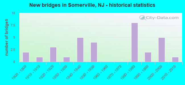
- New bridges - historical statistics
- 21900-1909
- 11910-1919
- 31920-1929
- 11930-1939
- 51940-1949
- 41950-1959
- 81980-1989
- 21990-1999
- 52000-2009
- 12010-2019

- Reconstructed bridges - Historical Statistics
- 11970-1979
- 01980-1989
- 11990-1999
- 22000-2009


- Bridge Condition - Deck
- 71.4%Good
- 14.3%Satisfactory
- 7.1%Fair
- 7.1%Poor

- Bridge Condition - Superstructure
- 4.5%Very good
- 36.4%Good
- 40.9%Satisfactory
- 18.2%Fair

- Bridge Condition - Substructure
- 27.3%Good
- 36.4%Satisfactory
- 31.8%Fair
- 4.5%Poor

- Bridge Condition - Channel
- 66.7%Satisfactory
- 27.8%Fair
- 5.6%Poor

- Bridge Condition - Culverts
- 66.7%Good
- 33.3%Satisfactory
Find on map >> Show street view
Structure Number: 1801161, Location: .2 MI WEST OF 202&206 JCT (Lat: 40.582681, Lng: -74.625239), Route carried "on" structure: US 22, Year Built: 1949, Status: Open, Structure Length: 1.28m (4.20ft), Average Daily Traffic: 35,850 (year 2019), Truck Traffic: 4%, Average Future Daily Traffic: 43,750 (year 2038), Design Load: HS 20, Features Intersected: PETERS BROOK
Minimum Vertical Clearance: 30+ m (98+ ft), Kilometerpoint: 54.267, Lanes on structure: 5, Base Highway Network: Yes, Owner: State Highway Agency, Approaching Roadway Width: 23.8m (78.1ft), Skew: 20 degrees, Material/Design: Concrete, Design/Construction: Arch - Deck, Number Of Spans In Main Unit: 1, Length of Maximum Span: 12.2m (40.0ft), Curb or Sidewalk Widths: Left: 1.8m (5.9ft), Right: 1.8m (5.9ft), Curb-To-Curb Width: 23.8m (78.1ft), Out-to-Out Width: 42.0m (137.8ft)
Condition: Superstructure: Satisfactory, Substructure: Satisfactory, Channel: Satisfactory, Structural Evaluation: Equal to present minimum criteria, Deck Geometry: Better than present minimum criteria, Waterway Adequacy: Superior to present desirable criteria, Approach Roadway Alignment: Equal to present desirable criteria, Designated Inspection Frequency: Every 24 months, Inspection Date: May 2021
Find on map >> Show street view
Structure Number: 1801162, Location: 3 MI WEST OF I-287 JCT (Lat: 40.581669, Lng: -74.618331), Route carried "on" structure: US 22, Year Built: 1949, Status: Open, Structure Length: 1.71m (5.61ft), Average Daily Traffic: 46,767 (year 2020), Truck Traffic: 4%, Average Future Daily Traffic: 56,120 (year 2040), Features Intersected: US 202/206 NB RAMP
Minimum Vertical Clearance: 30+ m (98+ ft), Kilometerpoint: 54.830, Lanes on structure: 6, Lanes under structure: 1, Base Highway Network: Yes, Owner: State Highway Agency, Approaching Roadway Width: 22.9m (75.1ft), Skew: 32 degrees, Material/Design: Steel, Design/Construction: Stringer/Multi-beam, Number Of Spans In Main Unit: 1, Length of Maximum Span: 14.3m (46.9ft), Curb or Sidewalk Widths: Left: 1.8m (5.9ft), Right: 0.8m (2.6ft), Curb-To-Curb Width: 22.9m (75.1ft), Out-to-Out Width: 27.1m (88.9ft)
Condition: Deck: Satisfactory, Superstructure: Satisfactory, Substructure: Fair, Operating Rating: 65.3 metric tons, Method Used To Determine Operating Rating: Load Factor (LF), Inventory Rating: 39.0 metric tons, Method Used To Determine Inventory Rating: Load Factor (LF), Structural Evaluation: Somewhat better than minimum adequacy, Deck Geometry: Meets minimum limits, Underclear: Meets minimum limits, Approach Roadway Alignment: Equal to present desirable criteria, Designated Inspection Frequency: Every 24 months, Inspection Date: April 2020, Deck Structure Type: Concrete Cast-file-Place, Wearing Surface/Protective System: Wearing Surface: Latex Concrete
Find on map >> Show street view
Structure Number: 180215, Location: .86 MI EAST OF US 202&206 (Lat: 40.580269, Lng: -74.606300), Route carried "on" structure: City street , Year Built: 1953, Status: Open, Structure Length: 1.95m (6.40ft), Average Daily Traffic: 5,130 (year 2021), Truck Traffic: 4%, Average Future Daily Traffic: 6,160 (year 2041), Design Load: HS 20, Features Intersected: US 22 EB, Facility Carried by Structure: GROVE ST.
Minimum Vertical Clearance: 30+ m (98+ ft), Kilometerpoint: 2.897, Lanes on structure: 2, Lanes under structure: 4, Owner: State Highway Agency, Approaching Roadway Width: 9.1m (29.9ft), Material/Design: Concrete, Design/Construction: Frame, Number Of Spans In Main Unit: 1, Length of Maximum Span: 19.5m (64.0ft), Curb or Sidewalk Widths: Left: 1.6m (5.2ft), Right: 1.6m (5.2ft), Curb-To-Curb Width: 9.1m (29.9ft), Out-to-Out Width: 12.8m (42.0ft)
Condition: Deck: Good, Superstructure: Satisfactory, Substructure: Good, Operating Rating: 61.7 metric tons, Method Used To Determine Operating Rating: Load Factor (LF), Inventory Rating: 37.2 metric tons, Method Used To Determine Inventory Rating: Load Factor (LF), Structural Evaluation: Equal to present minimum criteria, Deck Geometry: High priority of corrective action, Underclear: Equal to present minimum criteria, Approach Roadway Alignment: Equal to present minimum criteria, Designated Inspection Frequency: Every 24 months, Inspection Date: August 2021, Deck Structure Type: Concrete Cast-file-Place, Wearing Surface/Protective System: Wearing Surface: Bituminous
Find on map >> Show street view
Structure Number: 1802153, Location: 1.1 MI E. OF US 202/206 (Lat: 40.580919, Lng: -74.602739), Route carried "on" structure: US 22, Year Built: 1951, Status: Open, Structure Length: 0.76m (2.49ft), Average Daily Traffic: 21,750 (year 2021), Truck Traffic: 4%, Average Future Daily Traffic: 26,100 (year 2041), Features Intersected: ROSS BROOK
Minimum Vertical Clearance: 30+ m (98+ ft), Kilometerpoint: 56.134, Lanes on structure: 3, Base Highway Network: Yes, Owner: State Highway Agency, Approaching Roadway Width: 14.6m (47.9ft), Skew: 3 degrees, Material/Design: Concrete, Design/Construction: Culvert, Number Of Spans In Main Unit: 1, Length of Maximum Span: 7.0m (23.0ft)
Condition: Channel: Satisfactory, Culverts: Good, Operating Rating: 55.3 metric tons, Method Used To Determine Operating Rating: Load Factor (LF), Inventory Rating: 32.7 metric tons, Method Used To Determine Inventory Rating: Load Factor (LF), Structural Evaluation: Better than present minimum criteria, Waterway Adequacy: Better than present minimum criteria, Approach Roadway Alignment: Equal to present desirable criteria, Designated Inspection Frequency: Every 24 months, Inspection Date: August 2021
Find on map >> Show street view
Structure Number: 180216, Location: .49 MI E.OF 202/206/22INT (Lat: 40.581500, Lng: -74.613089), Route carried "on" structure: Ramp US 22, Year Built: 1988, Status: Open, Structure Length: 3.23m (10.60ft), Average Daily Traffic: 8,503 (year 2020), Truck Traffic: 4%, Average Future Daily Traffic: 10,205 (year 2040), Design Load: HS 20+Mod, Features Intersected: US 22 WESTBOUND
Minimum Vertical Clearance: 30+ m (98+ ft), Kilometerpoint: 55.313, Lanes on structure: 1, Lanes under structure: 3, Owner: State Highway Agency, Approaching Roadway Width: 7.3m (24.0ft), Skew: 4 degrees, Material/Design: Steel, Design/Construction: Stringer/Multi-beam, Number Of Spans In Main Unit: 1, Length of Maximum Span: 30.2m (99.1ft), Curb-To-Curb Width: 7.3m (24.0ft), Out-to-Out Width: 8.4m (27.6ft)
Condition: Deck: Good, Superstructure: Satisfactory, Substructure: Satisfactory, Inventory Rating: 63.5 metric tons, Method Used To Determine Inventory Rating: Load Factor (LF), Structural Evaluation: Equal to present minimum criteria, Deck Geometry: Better than present minimum criteria, Underclear: Equal to present minimum criteria, Approach Roadway Alignment: Equal to present minimum criteria, Designated Inspection Frequency: Every 24 months, Inspection Date: August 2020, Deck Structure Type: Concrete Cast-file-Place, Wearing Surface/Protective System: Wearing Surface: Monolithic Concrete, Deck Protection: Epoxy Coated Reinforcing
Find on map >> Show street view
Structure Number: 180515, Location: 1.50 MILES EAST OF RT.202 (Lat: 40.566419, Lng: -74.605419), Route carried "on" structure: State highway 28, Year Built: 1958, Status: Open, Structure Length: 1.86m (6.10ft), Average Daily Traffic: 12,470 (year 2021), Truck Traffic: 4%, Average Future Daily Traffic: 15,900 (year 2041), Design Load: H 20, Features Intersected: PETERS BROOK
Minimum Vertical Clearance: 30+ m (98+ ft), Kilometerpoint: 5.987, Lanes on structure: 2, Base Highway Network: Yes, Owner: State Highway Agency, Approaching Roadway Width: 16.5m (54.1ft), Skew: 3 degrees, Material/Design: Prestressed concrete, Design/Construction: Stringer/Multi-beam, Number Of Spans In Main Unit: 1, Length of Maximum Span: 17.1m (56.1ft), Curb or Sidewalk Widths: Left: 1.8m (5.9ft), Right: 1.8m (5.9ft), Curb-To-Curb Width: 16.5m (54.1ft), Out-to-Out Width: 20.9m (68.6ft)
Condition: Deck: Fair, Superstructure: Fair, Substructure: Fair, Channel: Fair, Inventory Rating: 51.7 metric tons, Method Used To Determine Inventory Rating: Load Factor (LF), Structural Evaluation: Somewhat better than minimum adequacy, Deck Geometry: Superior to present desirable criteria, Waterway Adequacy: Equal to present minimum criteria, Approach Roadway Alignment: Equal to present desirable criteria, Designated Inspection Frequency: Every 24 months, Inspection Date: September 2021, Deck Structure Type: Concrete Cast-file-Place, Wearing Surface/Protective System: Wearing Surface: Monolithic Concrete
Find on map >> Show street view
Structure Number: 180815, Location: 0.17 MI SOUTH OF US22 (Lat: 40.580031, Lng: -74.623589), Route carried "on" structure: US 202, Year Built: 1929, Status: Open, Structure Length: 1.22m (4.00ft), Average Daily Traffic: 96,337 (year 2021), Truck Traffic: 4%, Average Future Daily Traffic: 115,604 (year 2041), Design Load: HS 20, Features Intersected: PETERS BROOK
Minimum Vertical Clearance: 30+ m (98+ ft), Kilometerpoint: 40.008, Lanes on structure: 5, Base Highway Network: Yes, Owner: State Highway Agency, Approaching Roadway Width: 21.3m (69.9ft), Skew: 31 degrees, Material/Design: Concrete, Design/Construction: Arch - Deck, Number Of Spans In Main Unit: 1, Length of Maximum Span: 12.2m (40.0ft), Curb or Sidewalk Widths: Left: 5.0m (16.4ft), Right: 3.2m (10.5ft), Curb-To-Curb Width: 21.3m (69.9ft), Out-to-Out Width: 31.5m (103.3ft)
Condition: Superstructure: Fair, Substructure: Fair, Channel: Fair, Structural Evaluation: Somewhat better than minimum adequacy, Deck Geometry: Somewhat better than minimum adequacy, Waterway Adequacy: Superior to present desirable criteria, Approach Roadway Alignment: Equal to present desirable criteria, Designated Inspection Frequency: Every 24 months, Inspection Date: June 2021
Find on map >> Show street view
Structure Number: 1808151, Location: 0.6 MI N OF NJ 28 JCT (Lat: 40.582500, Lng: -74.622219), Route carried "on" structure: US 202, Year Built: 1948, Status: Open, Structure Length: 3.26m (10.70ft), Average Daily Traffic: 40,326 (year 2020), Truck Traffic: 4%, Average Future Daily Traffic: 48,391 (year 2040), Design Load: H 20, Features Intersected: US 22
Minimum Vertical Clearance: 30+ m (98+ ft), Kilometerpoint: 40.282, Lanes on structure: 3, Lanes under structure: 6, Base Highway Network: Yes, Owner: State Highway Agency, Approaching Roadway Width: 10.7m (35.1ft), Material/Design: Steel, Design/Construction: Stringer/Multi-beam, Number Of Spans In Main Unit: 2, Length of Maximum Span: 15.2m (49.9ft), Curb or Sidewalk Widths: Left: 1.2m (3.9ft), Right: 1.2m (3.9ft), Curb-To-Curb Width: 10.7m (35.1ft), Out-to-Out Width: 14.9m (48.9ft)
Condition: Deck: Poor, Superstructure: Fair, Substructure: Fair, Operating Rating: 56.2 metric tons, Method Used To Determine Operating Rating: Load Factor (LF), Inventory Rating: 33.6 metric tons, Method Used To Determine Inventory Rating: Load Factor (LF), Structural Evaluation: Somewhat better than minimum adequacy, Deck Geometry: High priority of replacement, Underclear: Equal to present minimum criteria, Approach Roadway Alignment: Equal to present minimum criteria, Length Of Structure Improvement: 3.26m (10.70ft), Designated Inspection Frequency: Every 24 months, Inspection Date: Febuary 2020, Bridge Improvement Cost: $2,000, Total Project Cost: $3,000 ( Estimate for 2020), Deck Structure Type: Concrete Cast-file-Place, Wearing Surface/Protective System: Wearing Surface: Latex Concrete
Find on map >> Show street view
Structure Number: 1808171, Location: 0.6 MI N.OF 202/206 JCT. (Lat: 40.582031, Lng: -74.621881), Route carried "on" structure: US 202, Year Built: 1987, Status: Open, Structure Length: 5.30m (17.39ft), Average Daily Traffic: 43,810 (year 2021), Truck Traffic: 4%, Average Future Daily Traffic: 52,510 (year 2041), Design Load: HS 20+Mod, Features Intersected: US 22
Minimum Vertical Clearance: 30+ m (98+ ft), Kilometerpoint: 40.282, Lanes on structure: 3, Lanes under structure: 6, Base Highway Network: Yes, Owner: State Highway Agency, Approaching Roadway Width: 11.9m (39.0ft), Material/Design: Steel continuous, Design/Construction: Stringer/Multi-beam, Number Of Spans In Main Unit: 2, Length of Maximum Span: 26.5m (86.9ft), Curb or Sidewalk Widths: Left: 0.0m, Right: 1.8m (5.9ft), Curb-To-Curb Width: 12.0m (39.4ft), Out-to-Out Width: 14.5m (47.6ft)
Condition: Deck: Good, Superstructure: Satisfactory, Substructure: Satisfactory, Inventory Rating: 61.7 metric tons, Method Used To Determine Inventory Rating: Load Factor (LF), Structural Evaluation: Equal to present minimum criteria, Deck Geometry: Meets minimum limits, Underclear: Better than present minimum criteria, Approach Roadway Alignment: Equal to present desirable criteria, Designated Inspection Frequency: Every 24 months, Inspection Date: April 2021, Deck Structure Type: Concrete Cast-file-Place, Wearing Surface/Protective System: Wearing Surface: Monolithic Concrete, Deck Protection: Epoxy Coated Reinforcing
Find on map >> Show street view
Structure Number: 1808172, Location: 633' E of ST.Police Stati (Lat: 40.581650, Lng: -74.620919), Route carried "on" structure: Ramp US 202, Year Built: 1987, Status: Open, Structure Length: 4.54m (14.90ft), Average Daily Traffic: 38,580 (year 2021), Truck Traffic: 4%, Average Future Daily Traffic: 46,280 (year 2041), Design Load: HS 20+Mod, Features Intersected: US 22 RAMP M
Minimum Vertical Clearance: 30+ m (98+ ft), Kilometerpoint: 40.250, Lanes on structure: 1, Lanes under structure: 1, Owner: State Highway Agency, Approaching Roadway Width: 7.3m (24.0ft), Skew: 4 degrees, Material/Design: Steel continuous, Design/Construction: Stringer/Multi-beam, Number Of Spans In Main Unit: 3, Length of Maximum Span: 17.7m (58.1ft), Curb-To-Curb Width: 7.3m (24.0ft), Out-to-Out Width: 8.4m (27.6ft)
Condition: Deck: Good, Superstructure: Good, Substructure: Good, Operating Rating: 78.0 metric tons, Method Used To Determine Operating Rating: Load Factor (LF), Inventory Rating: 46.3 metric tons, Method Used To Determine Inventory Rating: Load Factor (LF), Structural Evaluation: Better than present minimum criteria, Deck Geometry: Better than present minimum criteria, Underclear: Meets minimum limits, Approach Roadway Alignment: Equal to present minimum criteria, Designated Inspection Frequency: Every 24 months, Inspection Date: April 2021, Deck Structure Type: Concrete Cast-file-Place, Wearing Surface/Protective System: Wearing Surface: Monolithic Concrete, Deck Protection: Epoxy Coated Reinforcing
Find on map >> Show street view
Structure Number: 1808173, Location: JCT OF US 202-206 & US 22 (Lat: 40.581311, Lng: -74.624039), Route carried "on" structure: ServiceOther road 22, Year Built: 1987, Status: Open, Structure Length: 3.23m (10.60ft), Average Daily Traffic: 552 (year 2021), Truck Traffic: 1%, Average Future Daily Traffic: 674 (year 2041), Design Load: HS 20+Mod, Features Intersected: RAMP I, Facility Carried by Structure: NJSP ACCESS ROAD
Minimum Vertical Clearance: 30+ m (98+ ft), Kilometerpoint: 54.331, Lanes on structure: 2, Lanes under structure: 1, Owner: State Highway Agency, Approaching Roadway Width: 7.3m (24.0ft), Skew: 2 degrees, Material/Design: Steel, Design/Construction: Stringer/Multi-beam, Number Of Spans In Main Unit: 1, Length of Maximum Span: 30.5m (100.1ft), Curb-To-Curb Width: 7.3m (24.0ft), Out-to-Out Width: 8.4m (27.6ft)
Condition: Deck: Good, Superstructure: Good, Substructure: Satisfactory, Inventory Rating: 56.2 metric tons, Method Used To Determine Inventory Rating: Load Factor (LF), Structural Evaluation: Equal to present minimum criteria, Deck Geometry: Meets minimum limits, Underclear: Somewhat better than minimum adequacy, Approach Roadway Alignment: Equal to present desirable criteria, Designated Inspection Frequency: Every 24 months, Inspection Date: July 2021, Deck Structure Type: Concrete Cast-file-Place, Wearing Surface/Protective System: Wearing Surface: Monolithic Concrete, Deck Protection: Epoxy Coated Reinforcing
Find on map >> Show street view
Structure Number: 1810169, Location: .16 Mile South of 608 JCT (Lat: 40.552581, Lng: -74.614961), Route carried "on" structure: US 206, Year Built: 2002, Status: Open, Structure Length: 1.34m (4.40ft), Average Daily Traffic: 40,839 (year 2021), Truck Traffic: 4%, Average Future Daily Traffic: 49,831 (year 2041), Design Load: HS 25 or greater, Features Intersected: DUKES BROOK
Minimum Vertical Clearance: 30+ m (98+ ft), Kilometerpoint: 111.817, Lanes on structure: 7, Base Highway Network: Yes, Owner: State Highway Agency, Approaching Roadway Width: 33.2m (108.9ft), Skew: 34 degrees, Material/Design: Concrete, Design/Construction: Culvert, Number Of Spans In Main Unit: 2, Length of Maximum Span: 6.1m (20.0ft), Curb or Sidewalk Widths: Left: 3.4m (11.2ft), Right: 0.0m
Condition: Channel: Satisfactory, Culverts: Good, Operating Rating: 71.7 metric tons, Method Used To Determine Operating Rating: Load Factor (LF), Inventory Rating: 42.6 metric tons, Method Used To Determine Inventory Rating: Load Factor (LF), Structural Evaluation: Better than present minimum criteria, Waterway Adequacy: Superior to present desirable criteria, Approach Roadway Alignment: Equal to present desirable criteria, Designated Inspection Frequency: Every 24 months, Inspection Date: April 2021
Find on map >> Show street view
Structure Number: 181017, Location: 1.5 MI S OF RT 202 JCT (Lat: 40.555639, Lng: -74.615431), Route carried "on" structure: US 206, Year Built: 2003, Status: Open, Structure Length: 12.22m (40.09ft), Average Daily Traffic: 34,495 (year 2020), Truck Traffic: 4%, Average Future Daily Traffic: 42,090 (year 2040), Design Load: HS 25 or greater, Features Intersected: RARITAN RIVER
Minimum Vertical Clearance: 30+ m (98+ ft), Kilometerpoint: 112.284, Lanes on structure: 8, Base Highway Network: Yes, Owner: State Highway Agency, Approaching Roadway Width: 33.8m (110.9ft), Skew: 30 degrees, Material/Design: Steel continuous, Design/Construction: Stringer/Multi-beam, Number Of Spans In Main Unit: 3, Length of Maximum Span: 46.3m (151.9ft), Curb or Sidewalk Widths: Left: 2.4m (7.9ft), Right: 1.8m (5.9ft), Curb-To-Curb Width: 34.1m (111.9ft), Out-to-Out Width: 39.7m (130.2ft)
Condition: Deck: Good, Superstructure: Very good, Substructure: Good, Channel: Satisfactory, Operating Rating: 80.7 metric tons, Method Used To Determine Operating Rating: Field evaluation and documented engineering judgment, Inventory Rating: 40.8 metric tons, Method Used To Determine Inventory Rating: Field evaluation and documented engineering judgment, Structural Evaluation: Better than present minimum criteria, Deck Geometry: Equal to present minimum criteria, Waterway Adequacy: Superior to present desirable criteria, Approach Roadway Alignment: Equal to present desirable criteria, Designated Inspection Frequency: Every 24 months, Inspection Date: April 2020, Deck Structure Type: Concrete Cast-file-Place, Wearing Surface/Protective System: Wearing Surface: Latex Concrete, Deck Protection: Epoxy Coated Reinforcing
Find on map >> Show street view
Structure Number: 181018, Location: .16M south of Dukes Park (Lat: 40.551381, Lng: -74.615119), Route carried "on" structure: US 206, Year Built: 2003, Status: Open, Structure Length: 1.04m (3.41ft), Average Daily Traffic: 35,102 (year 2020), Truck Traffic: 4%, Average Future Daily Traffic: 41,122 (year 2040), Features Intersected: BRANCH OF DUKES BROOK
Minimum Vertical Clearance: 0.00m, Kilometerpoint: 111.817, Lanes on structure: 7, Base Highway Network: Yes, Owner: State Highway Agency, Approaching Roadway Width: 33.5m (109.9ft), Skew: 34 degrees, Material/Design: Concrete, Design/Construction: Culvert, Number Of Spans In Main Unit: 1, Length of Maximum Span: 4.6m (15.1ft)
Condition: Channel: Satisfactory, Culverts: Satisfactory, Operating Rating: 45.4 metric tons, Method Used To Determine Operating Rating: Field evaluation and documented engineering judgment, Inventory Rating: 32.7 metric tons, Method Used To Determine Inventory Rating: Field evaluation and documented engineering judgment, Structural Evaluation: Equal to present minimum criteria, Waterway Adequacy: Superior to present desirable criteria, Approach Roadway Alignment: Equal to present desirable criteria, Designated Inspection Frequency: Every 24 months, Inspection Date: September 2020
Find on map >> Show street view
Structure Number: 18F0703, Location: 0.12 MILE EAST OF US 206 (Lat: 40.553919, Lng: -74.613331), Route carried "on" structure: County highway 608, Year Built: 1995, Status: Open, Structure Length: 1.07m (3.51ft), Average Daily Traffic: 9,340 (year 2021), Truck Traffic: 3%, Average Future Daily Traffic: 11,208 (year 2041), Design Load: HS 20+Mod, Features Intersected: DUKES BROOK, Facility Carried by Structure: EAST DUKES PKWY
Minimum Vertical Clearance: 30+ m (98+ ft), Kilometerpoint: 0.193, Lanes on structure: 2, Owner: County Highway Agency, Approaching Roadway Width: 11.6m (38.1ft), Material/Design: Prestressed concrete, Design/Construction: Box Beam or Girders - Single/Spread, Number Of Spans In Main Unit: 1, Length of Maximum Span: 9.4m (30.8ft), Curb or Sidewalk Widths: Left: 0.2m (0.7ft), Right: 0.2m (0.7ft), Curb-To-Curb Width: 12.1m (39.7ft), Out-to-Out Width: 13.3m (43.6ft)
Condition: Deck: Good, Superstructure: Good, Substructure: Satisfactory, Channel: Satisfactory, Inventory Rating: 70.8 metric tons, Method Used To Determine Inventory Rating: Load Factor (LF), Structural Evaluation: Equal to present minimum criteria, Deck Geometry: Somewhat better than minimum adequacy, Waterway Adequacy: Equal to present minimum criteria, Approach Roadway Alignment: Equal to present desirable criteria, Designated Inspection Frequency: Every 24 months, Inspection Date: October 2021, Deck Structure Type: Concrete Cast-file-Place, Wearing Surface/Protective System: Wearing Surface: Monolithic Concrete, Deck Protection: Epoxy Coated Reinforcing
Find on map >> Show street view
Structure Number: 18F0707, Location: .04 MI E OF HAMILTON ST (Lat: 40.561450, Lng: -74.608000), Route carried "on" structure: City street , Year Built: 2007, Status: Open, Structure Length: 1.80m (5.91ft), Average Daily Traffic: 4,495 (year 2021), Truck Traffic: 1%, Average Future Daily Traffic: 5,394 (year 2041), Design Load: HS 25 or greater, Features Intersected: PETERS BROOK, Facility Carried by Structure: SOUTHSIDE AVENUE
Minimum Vertical Clearance: 30+ m (98+ ft), Kilometerpoint: 0.000, Lanes on structure: 2, Owner: County Highway Agency, Approaching Roadway Width: 9.1m (29.9ft), Material/Design: Steel, Design/Construction: Truss - Thru, Number Of Spans In Main Unit: 1, Length of Maximum Span: 16.5m (54.1ft), Curb or Sidewalk Widths: Left: 1.8m (5.9ft), Right: 0.0m, Curb-To-Curb Width: 9.2m (30.2ft), Out-to-Out Width: 10.7m (35.1ft)
Condition: Deck: Good, Superstructure: Good, Substructure: Good, Channel: Satisfactory, Operating Rating: 79.8 metric tons, Method Used To Determine Operating Rating: Load Factor (LF), Inventory Rating: 48.1 metric tons, Method Used To Determine Inventory Rating: Load Factor (LF), Structural Evaluation: Better than present minimum criteria, Deck Geometry: Meets minimum limits, Waterway Adequacy: Equal to present minimum criteria, Approach Roadway Alignment: Better than present minimum criteria, Designated Inspection Frequency: Every 24 months, Critical Feature Inspection Frequency: Every 24 months, Inspection Date: October 2021, Critical Feature Inspection Date: October 2021, Deck Structure Type: Concrete Cast-file-Place, Wearing Surface/Protective System: Wearing Surface: Monolithic Concrete
Find on map >> Show street view
Structure Number: 18F0803, Location: 0.19 MI WEST OF NJ RT 28 (Lat: 40.568631, Lng: -74.606431), Route carried "on" structure: City street , Year Built: 2005, Status: Open, Structure Length: 2.07m (6.79ft), Average Daily Traffic: 4,121 (year 2021), Truck Traffic: 3%, Average Future Daily Traffic: 4,945 (year 2041), Design Load: HS 25 or greater, Features Intersected: PETERS BROOK, Facility Carried by Structure: EAST HIGH ST
Minimum Vertical Clearance: 30+ m (98+ ft), Kilometerpoint: 1.207, Lanes on structure: 2, Owner: County Highway Agency, Approaching Roadway Width: 12.2m (40.0ft), Material/Design: Concrete, Design/Construction: Arch - Deck, Number Of Spans In Main Unit: 1, Length of Maximum Span: 20.7m (67.9ft), Curb or Sidewalk Widths: Left: 1.8m (5.9ft), Right: 1.8m (5.9ft), Curb-To-Curb Width: 12.2m (40.0ft), Out-to-Out Width: 17.3m (56.8ft)
Condition: Superstructure: Good, Substructure: Good, Channel: Satisfactory, Operating Rating: 71.7 metric tons, Method Used To Determine Operating Rating: Load Factor (LF), Inventory Rating: 42.6 metric tons, Method Used To Determine Inventory Rating: Load Factor (LF), Structural Evaluation: Better than present minimum criteria, Deck Geometry: Equal to present minimum criteria, Waterway Adequacy: Equal to present minimum criteria, Approach Roadway Alignment: Equal to present desirable criteria, Designated Inspection Frequency: Every 24 months, Inspection Date: October 2021
Find on map >> Show street view
Structure Number: 18F0804, Location: 0.17 MI E. of Grove Str. (Lat: 40.570239, Lng: -74.605939), Route carried "on" structure: City street , Year Built: 1915, Year Reconstructed: 2006, Status: Open, Structure Length: 2.29m (7.51ft), Average Daily Traffic: 3,290 (year 2021), Truck Traffic: 1%, Average Future Daily Traffic: 3,948 (year 2041), Features Intersected: PETERS BROOK, Facility Carried by Structure: EAST CLIFF STREET
Minimum Vertical Clearance: 30+ m (98+ ft), Kilometerpoint: 0.000, Lanes on structure: 2, Owner: County Highway Agency, Approaching Roadway Width: 11.9m (39.0ft), Skew: 3 degrees, Material/Design: Concrete, Design/Construction: Arch - Deck, Number Of Spans In Main Unit: 1, Length of Maximum Span: 22.9m (75.1ft), Curb or Sidewalk Widths: Left: 1.4m (4.6ft), Right: 1.6m (5.2ft), Curb-To-Curb Width: 11.9m (39.0ft), Out-to-Out Width: 15.8m (51.8ft)
Condition: Superstructure: Good, Substructure: Fair, Channel: Fair, Operating Rating: 32.7 metric tons, Method Used To Determine Operating Rating: Field evaluation and documented engineering judgment, Inventory Rating: 23.6 metric tons, Method Used To Determine Inventory Rating: Field evaluation and documented engineering judgment, Structural Evaluation: Somewhat better than minimum adequacy, Deck Geometry: Somewhat better than minimum adequacy, Waterway Adequacy: Better than present minimum criteria, Approach Roadway Alignment: Equal to present desirable criteria, Length Of Structure Improvement: 2.29m (7.51ft), Designated Inspection Frequency: Every 24 months, Inspection Date: September 2021
Find on map >> Show street view
Structure Number: 18F0805, Location: 0.37 mi N of NJ 28 (Lat: 40.572850, Lng: -74.608119), Route carried "on" structure: City street , Year Built: 1996, Status: Open, Structure Length: 1.83m (6.00ft), Average Daily Traffic: 10,923 (year 2021), Truck Traffic: 4%, Average Future Daily Traffic: 13,108 (year 2041), Design Load: HS 25 or greater, Features Intersected: PETERS BROOK, Facility Carried by Structure: GROVE ST
Minimum Vertical Clearance: 30+ m (98+ ft), Kilometerpoint: 0.612, Lanes on structure: 2, Owner: County Highway Agency, Approaching Roadway Width: 9.2m (30.2ft), Material/Design: Concrete, Design/Construction: Arch - Deck, Number Of Spans In Main Unit: 1, Length of Maximum Span: 18.3m (60.0ft), Curb or Sidewalk Widths: Left: 2.6m (8.5ft), Right: 2.6m (8.5ft), Curb-To-Curb Width: 9.2m (30.2ft), Out-to-Out Width: 15.2m (49.9ft)
Condition: Superstructure: Satisfactory, Substructure: Satisfactory, Channel: Satisfactory, Structural Evaluation: Equal to present minimum criteria, Deck Geometry: High priority of corrective action, Waterway Adequacy: Better than present minimum criteria, Approach Roadway Alignment: Equal to present desirable criteria, Length Of Structure Improvement: 1.83m (6.00ft), Designated Inspection Frequency: Every 24 months, Inspection Date: October 2021, Bridge Improvement Cost: $43,000, Roadway Improvement Cost: $9,000, Total Project Cost: $67,000 ( Estimate for 2019)
Find on map >> Show street view
Structure Number: 18F0806, Location: 1.17 MI. N. OF US. 206 (Lat: 40.573150, Lng: -74.610319), Route carried "on" structure: City street , Year Built: 1925, Year Reconstructed: 2003, Status: Open, Structure Length: 1.98m (6.50ft), Average Daily Traffic: 9,529 (year 2021), Truck Traffic: 4%, Average Future Daily Traffic: 11,435 (year 2041), Features Intersected: PETERS BROOK, Facility Carried by Structure: NORTH BRIDGE ST
Minimum Vertical Clearance: 30+ m (98+ ft), Kilometerpoint: 1.883, Lanes on structure: 2, Owner: County Highway Agency, Approaching Roadway Width: 9.2m (30.2ft), Skew: 2 degrees, Material/Design: Concrete, Design/Construction: Arch - Deck, Number Of Spans In Main Unit: 1, Length of Maximum Span: 19.2m (63.0ft), Curb or Sidewalk Widths: Left: 1.9m (6.2ft), Right: 1.9m (6.2ft), Curb-To-Curb Width: 9.2m (30.2ft), Out-to-Out Width: 13.7m (44.9ft)
Condition: Deck: Good, Superstructure: Satisfactory, Substructure: Satisfactory, Channel: Fair, Operating Rating: 32.7 metric tons, Method Used To Determine Operating Rating: Field evaluation and documented engineering judgment, Inventory Rating: 24.5 metric tons, Method Used To Determine Inventory Rating: Field evaluation and documented engineering judgment, Structural Evaluation: Equal to present minimum criteria, Deck Geometry: High priority of corrective action, Waterway Adequacy: Equal to present minimum criteria, Approach Roadway Alignment: Better than present minimum criteria, Length Of Structure Improvement: 1.98m (6.50ft), Designated Inspection Frequency: Every 24 months, Inspection Date: October 2021, Bridge Improvement Cost: $38,000, Roadway Improvement Cost: $16,000, Total Project Cost: $65,000 ( Estimate for 2021), Deck Structure Type: Concrete Cast-file-Place, Wearing Surface/Protective System: Wearing Surface: Bituminous, Deck Protection: Galvanized Reinforcing
Find on map >> Show street view
Structure Number: 18F0807, Location: 0.3 MI N. OF MAIN STREET (Lat: 40.573550, Lng: -74.614569), Route carried "on" structure: City street , Year Built: 1905, Year Reconstructed: 2008, Status: Open, Structure Length: 1.98m (6.50ft), Average Daily Traffic: 1,944 (year 2021), Truck Traffic: 3%, Average Future Daily Traffic: 2,332 (year 2041), Features Intersected: PETERS BROOK, Facility Carried by Structure: DAVENPORT STREET
Minimum Vertical Clearance: 30+ m (98+ ft), Kilometerpoint: 0.805, Lanes on structure: 2, Owner: County Highway Agency, Approaching Roadway Width: 9.1m (29.9ft), Material/Design: Concrete, Design/Construction: Arch - Deck, Number Of Spans In Main Unit: 2, Length of Maximum Span: 9.1m (29.9ft), Curb or Sidewalk Widths: Left: 2.1m (6.9ft), Right: 1.4m (4.6ft), Curb-To-Curb Width: 9.1m (29.9ft), Out-to-Out Width: 14.1m (46.3ft)
Condition: Superstructure: Satisfactory, Substructure: Poor, Channel: Satisfactory, Operating Rating: 32.7 metric tons, Method Used To Determine Operating Rating: Field evaluation and documented engineering judgment, Inventory Rating: 23.6 metric tons, Method Used To Determine Inventory Rating: Field evaluation and documented engineering judgment, Structural Evaluation: Meets minimum limits, Deck Geometry: Somewhat better than minimum adequacy, Waterway Adequacy: Superior to present desirable criteria, Approach Roadway Alignment: Equal to present minimum criteria, Length Of Structure Improvement: 1.98m (6.50ft), Designated Inspection Frequency: Every 24 months, Inspection Date: September 2021, Bridge Improvement Cost: $222,000, Roadway Improvement Cost: $1,000, Total Project Cost: $322,000 ( Estimate for 2017)
Find on map >> Show street view
Structure Number: 18F0808, Location: AT GREEN ST INTERSECTION (Lat: 40.574711, Lng: -74.615981), Route carried "on" structure: City street , Year Built: 2011, Status: Open, Structure Length: 2.74m (8.99ft), Average Daily Traffic: 2,535 (year 2021), Truck Traffic: 1%, Average Future Daily Traffic: 3,042 (year 2041), Design Load: HS 20+Mod, Features Intersected: PETERS BROOK, Facility Carried by Structure: MERCER STREET
Minimum Vertical Clearance: 30+ m (98+ ft), Kilometerpoint: 0.000, Lanes on structure: 2, Owner: County Highway Agency, Approaching Roadway Width: 11.0m (36.1ft), Skew: 4 degrees, Material/Design: Steel continuous, Design/Construction: Stringer/Multi-beam, Number Of Spans In Main Unit: 2, Length of Maximum Span: 13.1m (43.0ft), Curb or Sidewalk Widths: Left: 1.8m (5.9ft), Right: 1.8m (5.9ft), Curb-To-Curb Width: 11.0m (36.1ft), Out-to-Out Width: 15.2m (49.9ft)
Condition: Deck: Good, Superstructure: Good, Substructure: Good, Channel: Satisfactory, Operating Rating: 68.0 metric tons, Method Used To Determine Operating Rating: Load Factor (LF), Inventory Rating: 40.8 metric tons, Method Used To Determine Inventory Rating: Load Factor (LF), Structural Evaluation: Better than present minimum criteria, Deck Geometry: Somewhat better than minimum adequacy, Waterway Adequacy: Equal to present minimum criteria, Approach Roadway Alignment: Equal to present desirable criteria, Designated Inspection Frequency: Every 24 months, Inspection Date: October 2021, Deck Structure Type: Concrete Cast-file-Place, Wearing Surface/Protective System: Wearing Surface: Monolithic Concrete, Deck Protection: Galvanized Reinforcing
Find on map >> Show street view
Structure Number: 18F0809, Location: .23 MI SO. OF US 22 (Lat: 40.578169, Lng: -74.619050), Route carried "on" structure: County highway 643, Year Built: 1901, Year Reconstructed: 1977, Status: Open, Structure Length: 2.26m (7.41ft), Average Daily Traffic: 5,352 (year 2021), Truck Traffic: 3%, Average Future Daily Traffic: 6,422 (year 2041), Design Load: HS 20, Features Intersected: PETERS BROOK, Facility Carried by Structure: MOUNTAIN AVE
Minimum Vertical Clearance: 30+ m (98+ ft), Kilometerpoint: 0.901, Lanes on structure: 2, Owner: County Highway Agency, Approaching Roadway Width: 11.0m (36.1ft), Skew: 3 degrees, Material/Design: Prestressed concrete, Design/Construction: Slab, Number Of Spans In Main Unit: 2, Length of Maximum Span: 10.7m (35.1ft), Curb or Sidewalk Widths: Left: 1.5m (4.9ft), Right: 1.5m (4.9ft), Curb-To-Curb Width: 10.5m (34.4ft), Out-to-Out Width: 14.3m (46.9ft)
Condition: Deck: Satisfactory, Superstructure: Good, Substructure: Fair, Channel: Satisfactory, Operating Rating: 71.7 metric tons, Method Used To Determine Operating Rating: Load Factor (LF), Inventory Rating: 36.3 metric tons, Method Used To Determine Inventory Rating: Load Factor (LF), Structural Evaluation: Somewhat better than minimum adequacy, Deck Geometry: Meets minimum limits, Waterway Adequacy: Equal to present desirable criteria, Approach Roadway Alignment: Equal to present desirable criteria, Length Of Structure Improvement: 2.26m (7.41ft), Designated Inspection Frequency: Every 24 months, Inspection Date: October 2021, Bridge Improvement Cost: $302,000, Roadway Improvement Cost: $1,000, Total Project Cost: $402,000 ( Estimate for 2017), Deck Structure Type: Concrete Cast-file-Place, Wearing Surface/Protective System: Wearing Surface: Monolithic Concrete
Find on map >> Show street view
Structure Number: 18F081, Location: 0.1 MI EAST OF GROVE ST. (Lat: 40.572811, Lng: -74.606800), Route carried "on" structure: City street , Year Built: 1928, Status: Open, Structure Length: 0.91m (2.99ft), Average Daily Traffic: 3,831 (year 2021), Truck Traffic: 1%, Average Future Daily Traffic: 4,597 (year 2041), Features Intersected: ROSS BROOK, Facility Carried by Structure: WILLIAM STREET
Minimum Vertical Clearance: 30+ m (98+ ft), Kilometerpoint: 0.000, Lanes on structure: 2, Owner: County Highway Agency, Approaching Roadway Width: 11.0m (36.1ft), Material/Design: Concrete, Design/Construction: Arch - Deck, Number Of Spans In Main Unit: 1, Length of Maximum Span: 9.1m (29.9ft), Curb or Sidewalk Widths: Left: 2.4m (7.9ft), Right: 2.4m (7.9ft), Curb-To-Curb Width: 11.0m (36.1ft), Out-to-Out Width: 16.5m (54.1ft)
Condition: Superstructure: Fair, Substructure: Fair, Channel: Fair, Operating Rating: 32.7 metric tons, Method Used To Determine Operating Rating: Field evaluation and documented engineering judgment, Inventory Rating: 23.6 metric tons, Method Used To Determine Inventory Rating: Field evaluation and documented engineering judgment, Structural Evaluation: Somewhat better than minimum adequacy, Deck Geometry: Somewhat better than minimum adequacy, Waterway Adequacy: Equal to present desirable criteria, Approach Roadway Alignment: Equal to present desirable criteria, Designated Inspection Frequency: Every 24 months, Inspection Date: September 2021
Find on map >> Show street view
Structure Number: 18F0811, Location: 0.06 MI EAST OF GROVE ST (Lat: 40.574700, Lng: -74.606481), Route carried "on" structure: City street , Year Built: 1931, Status: Open, Structure Length: 0.61m (2.00ft), Average Daily Traffic: 3,224 (year 2021), Truck Traffic: 1%, Average Future Daily Traffic: 3,869 (year 2041), Features Intersected: ROSS BROOK, Facility Carried by Structure: SPRING STREET
Minimum Vertical Clearance: 30+ m (98+ ft), Kilometerpoint: 0.000, Lanes on structure: 2, Owner: County Highway Agency, Approaching Roadway Width: 9.8m (32.2ft), Skew: 2 degrees, Material/Design: Concrete, Design/Construction: Frame, Number Of Spans In Main Unit: 1, Length of Maximum Span: 6.1m (20.0ft), Curb or Sidewalk Widths: Left: 2.1m (6.9ft), Right: 3.0m (9.8ft), Curb-To-Curb Width: 9.3m (30.5ft), Out-to-Out Width: 15.1m (49.5ft)
Condition: Superstructure: Satisfactory, Substructure: Satisfactory, Channel: Poor, Operating Rating: 34.3 metric tons, Method Used To Determine Operating Rating: Load and Resistance Factor Rating (LRFR) rating reported by rating factor(RF) method using HL-93 loadings, Inventory Rating: 24.9 metric tons, Method Used To Determine Inventory Rating: Load and Resistance Factor Rating (LRFR) rating reported by rating factor(RF) method using HL-93 loadings, Structural Evaluation: Equal to present minimum criteria, Deck Geometry: Meets minimum limits, Waterway Adequacy: Better than present minimum criteria, Approach Roadway Alignment: Equal to present desirable criteria, Designated Inspection Frequency: Every 24 months, Inspection Date: September 2021, Wearing Surface/Protective System: Wearing Surface: Bituminous
Find on map >> Show street view
Structure Number: 1801162, Location: 3 MI WEST OF I-287 JCT (Lat: 40.581669, Lng: -74.618331), Route carried "under" structure: Ramp US 202, Year Built: 1949, Structure Length: 0. m, Average Daily Traffic: 5,730 (year 2020), Truck Traffic: 4%, Features Intersected: US 202/206 NB RAMP, Facility Carried by Structure: US 22
Minimum Vertical Clearance: 4.45m (14.60ft), Kilometerpoint: 40.282, Lanes on structure: 6, Lanes under structure: 1, Material/Design: Steel, Design/Construction: Stringer/Multi-beam, Length of Maximum Span: 14.3m (46.9ft)
Find on map >> Show street view
Structure Number: 180215, Location: .86 MI EAST OF US 202&206 (Lat: 40.580269, Lng: -74.606300), Route carried "under" structure: US 22, Year Built: 1953, Structure Length: 0. m, Average Daily Traffic: 52,100 (year 2021), Truck Traffic: 4%, Features Intersected: US 22 EB, Facility Carried by Structure: GROVE ST.
Minimum Vertical Clearance: 5.13m (16.83ft), Kilometerpoint: 55.876, Lanes on structure: 2, Lanes under structure: 4, Material/Design: Concrete, Design/Construction: Frame, Length of Maximum Span: 19.5m (64.0ft)
Find on map >> Show street view
Structure Number: 180216, Location: .49 MI E.OF 202/206/22INT (Lat: 40.581500, Lng: -74.613089), Route carried "under" structure: US 22, Year Built: 1988, Structure Length: 0. m, Average Daily Traffic: 16,280 (year 2020), Truck Traffic: 4%, Features Intersected: US 22 WESTBOUND
Minimum Vertical Clearance: 5.31m (17.42ft), Kilometerpoint: 55.313, Lanes on structure: 1, Lanes under structure: 3, Material/Design: Steel, Design/Construction: Stringer/Multi-beam, Length of Maximum Span: 30.2m (99.1ft)
Find on map >> Show street view
Structure Number: 1808151, Location: 0.6 MI N OF NJ 28 JCT (Lat: 40.582500, Lng: -74.622219), Route carried "under" structure: US 22, Year Built: 1948, Structure Length: 0. m, Average Daily Traffic: 45,445 (year 2020), Truck Traffic: 4%, Features Intersected: US 22, Facility Carried by Structure: US 202 & 206 S.B.
Minimum Vertical Clearance: 4.62m (15.16ft), Kilometerpoint: 54.525, Lanes on structure: 3, Lanes under structure: 6, Material/Design: Steel, Design/Construction: Stringer/Multi-beam, Length of Maximum Span: 15.2m (49.9ft)
Find on map >> Show street view
Structure Number: 1808171, Location: 0.6 MI N.OF 202/206 JCT. (Lat: 40.582031, Lng: -74.621881), Route carried "under" structure: US 22, Year Built: 1987, Structure Length: 0. m, Average Daily Traffic: 43,500 (year 2021), Truck Traffic: 4%, Features Intersected: US 22, Facility Carried by Structure: US 202/206 NB
Minimum Vertical Clearance: 5.23m (17.16ft), Kilometerpoint: 54.525, Lanes on structure: 3, Lanes under structure: 6, Material/Design: Steel continuous, Design/Construction: Stringer/Multi-beam, Length of Maximum Span: 26.5m (86.9ft)
Find on map >> Show street view
Structure Number: 1808172, Location: 633' E of ST.Police Stati (Lat: 40.581650, Lng: -74.620919), Route carried "under" structure: Ramp US 22, Year Built: 1987, Structure Length: 0. m, Average Daily Traffic: 10,400 (year 2021), Truck Traffic: 4%, Features Intersected: US 22 RAMP M, Facility Carried by Structure: US202 RAMP L
Minimum Vertical Clearance: 5.05m (16.57ft), Kilometerpoint: 54.734, Lanes on structure: 1, Lanes under structure: 1, Material/Design: Steel continuous, Design/Construction: Stringer/Multi-beam, Length of Maximum Span: 17.7m (58.1ft)
Find on map >> Show street view
Structure Number: 1808173, Location: JCT OF US 202-206 & US 22 (Lat: 40.581311, Lng: -74.624039), Route carried "under" structure: Ramp US 22, Year Built: 1987, Structure Length: 0. m, Average Daily Traffic: 7,954 (year 2021), Truck Traffic: 4%, Features Intersected: RAMP I, Facility Carried by Structure: NJSP ACCESS ROAD
Minimum Vertical Clearance: 5.21m (17.09ft), Kilometerpoint: 54.331, Lanes on structure: 2, Lanes under structure: 1, Material/Design: Steel, Design/Construction: Stringer/Multi-beam, Length of Maximum Span: 30.5m (100.1ft)