Bridge Statistics for Soledad, California (CA)
Condition, Traffic, Stress, Structural Evaluation, Project Costs
- National Bridge Inventory (NBI) Statistics
- 16Number of bridges
- 512ft / 156mTotal length
- $1,562,000Total costs
- 246,010Total average daily traffic
- 24,781Total average daily truck traffic
- National Bridge Inventory (NBI) Registered Bridges for Soledad
- No street view available for this location
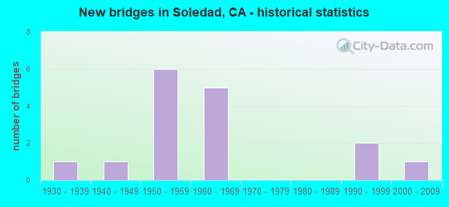
- New bridges - historical statistics
- 11930-1939
- 11940-1949
- 61950-1959
- 51960-1969
- 21990-1999
- 12000-2009

- Reconstructed bridges - Historical Statistics
- 11990-1999
- 12000-2009


- Bridge Condition - Deck
- 66.7%Good
- 11.1%Satisfactory
- 11.1%Fair
- 11.1%Poor

- Bridge Condition - Substructure
- 88.9%Good
- 11.1%Fair

- Bridge Condition - Channel
- 75.0%Excellent
- 25.0%Very good
Find on map >> Show street view
Structure Number: 44 0002L, Location: 05-MON-101-60.75 (Lat: 36.407981, Lng: -121.318856), Route carried "on" structure: US 101, Year Built: 1999, Status: Open, Structure Length: 47.08m (154.46ft), Average Daily Traffic: 18,600 (year 2009), Average Future Daily Traffic: 27,850 (year 2038), Design Load: HS 20+Mod, Features Intersected: SALINAS RIVER
Minimum Vertical Clearance: 30+ m (98+ ft), Kilometerpoint: 60.750, Lanes on structure: 2, Base Highway Network: Yes (Inventory Route: 1, Subroute: 1), Owner: State Highway Agency, Approaching Roadway Width: 11.9m (39.0ft), Material/Design: Prestressed concrete continuous, Design/Construction: Box Beam or Girders - Multiple, Number Of Spans In Main Unit: 11, Length of Maximum Span: 43.4m (142.4ft), Curb-To-Curb Width: 11.9m (39.0ft), Out-to-Out Width: 13.0m (42.7ft)
Condition: Deck: Good, Superstructure: Good, Substructure: Good, Channel: Very good, Operating Rating: 54.1 metric tons, Method Used To Determine Operating Rating: Assigned rating based on Load Factor Design (LFD) reported in metric tons, Inventory Rating: 32.4 metric tons, Method Used To Determine Inventory Rating: Assigned rating based on Load Factor Design (LFD) reported in metric tons, Structural Evaluation: Better than present minimum criteria, Deck Geometry: Better than present minimum criteria, Waterway Adequacy: Equal to present desirable criteria, Approach Roadway Alignment: Equal to present desirable criteria, Designated Inspection Frequency: Every 24 months, Inspection Date: May 2020, Deck Structure Type: Concrete Cast-file-Place
Find on map >> Show street view
Structure Number: 44 0002R, Location: 05-MON-101-60.75 (Lat: 36.408036, Lng: -121.318608), Route carried "on" structure: US 101, Year Built: 1999, Status: Open, Structure Length: 47.08m (154.46ft), Average Daily Traffic: 18,600 (year 2009), Average Future Daily Traffic: 27,850 (year 2038), Design Load: HS 20+Mod, Features Intersected: SALINAS RIVER
Minimum Vertical Clearance: 30+ m (98+ ft), Kilometerpoint: 60.750, Lanes on structure: 2, Base Highway Network: Yes (Inventory Route: 1, Subroute: 1), Owner: State Highway Agency, Approaching Roadway Width: 11.9m (39.0ft), Material/Design: Prestressed concrete continuous, Design/Construction: Box Beam or Girders - Multiple, Number Of Spans In Main Unit: 11, Length of Maximum Span: 43.4m (142.4ft), Curb-To-Curb Width: 11.9m (39.0ft), Out-to-Out Width: 13.0m (42.7ft)
Condition: Deck: Good, Superstructure: Good, Substructure: Good, Channel: Excellent, Operating Rating: 54.1 metric tons, Method Used To Determine Operating Rating: Assigned rating based on Load Factor Design (LFD) reported in metric tons, Inventory Rating: 32.4 metric tons, Method Used To Determine Inventory Rating: Assigned rating based on Load Factor Design (LFD) reported in metric tons, Structural Evaluation: Better than present minimum criteria, Deck Geometry: Better than present minimum criteria, Waterway Adequacy: Equal to present desirable criteria, Approach Roadway Alignment: Equal to present desirable criteria, Designated Inspection Frequency: Every 24 months, Inspection Date: May 2020, Deck Structure Type: Concrete Cast-file-Place
Find on map >> Show street view
Structure Number: 44 0091L, Location: 05-MON-101-62.70 (Lat: 36.431156, Lng: -121.337211), Route carried "on" structure: US 101, Year Built: 1960, Year Reconstructed: 2009, Status: Open, Structure Length: 9.55m (31.33ft), Average Daily Traffic: 18,660 (year 2009), Truck Traffic: 16%, Average Future Daily Traffic: 23,260 (year 2042), Design Load: HS 20, Features Intersected: UP RR, AMTRAK, FRONT ST
Minimum Vertical Clearance: 30+ m (98+ ft), Kilometerpoint: 62.700, Lanes on structure: 2, Lanes under structure: 2, Base Highway Network: Yes (Inventory Route: 1, Subroute: 1), Owner: State Highway Agency, Approaching Roadway Width: 9.1m (29.9ft), Skew: 5 degrees, Material/Design: Steel, Design/Construction: Stringer/Multi-beam, Number Of Spans In Main Unit: 4, Length of Maximum Span: 28.0m (91.9ft), Curb-To-Curb Width: 9.1m (29.9ft), Out-to-Out Width: 10.0m (32.8ft)
Condition: Deck: Satisfactory, Superstructure: Good, Substructure: Good, Operating Rating: 75.5 metric tons, Method Used To Determine Operating Rating: Load Factor (LF), Inventory Rating: 45.0 metric tons, Method Used To Determine Inventory Rating: Load Factor (LF), Structural Evaluation: Better than present minimum criteria, Deck Geometry: Meets minimum limits, Underclear: Meets minimum limits, Approach Roadway Alignment: Equal to present desirable criteria, Designated Inspection Frequency: Every 24 months, Other Special Inspection Frequency: Every 48 months, Inspection Date: May 2020, Other Special Inspection Date: July 2018, Deck Structure Type: Concrete Cast-file-Place, Wearing Surface/Protective System: Wearing Surface: Integral Concrete
Find on map >> Show street view
Structure Number: 44 0091R, Location: 05-MON-101-62.70 (Lat: 36.430981, Lng: -121.336911), Route carried "on" structure: US 101, Year Built: 1960, Status: Open, Structure Length: 9.55m (31.33ft), Average Daily Traffic: 18,200 (year 2009), Truck Traffic: 16%, Average Future Daily Traffic: 22,852 (year 2042), Design Load: HS 20, Features Intersected: UP RR, AMTRAK, FRONT ST
Minimum Vertical Clearance: 30+ m (98+ ft), Kilometerpoint: 62.700, Lanes on structure: 2, Lanes under structure: 2, Base Highway Network: Yes (Inventory Route: 1, Subroute: 1), Owner: State Highway Agency, Approaching Roadway Width: 8.5m (27.9ft), Skew: 5 degrees, Material/Design: Steel, Design/Construction: Stringer/Multi-beam, Number Of Spans In Main Unit: 4, Length of Maximum Span: 28.0m (91.9ft), Curb or Sidewalk Widths: Left: 0.6m (2.0ft), Right: 0.6m (2.0ft), Curb-To-Curb Width: 8.5m (27.9ft), Out-to-Out Width: 10.3m (33.8ft)
Condition: Deck: Poor, Superstructure: Good, Substructure: Good, Operating Rating: 76.8 metric tons, Method Used To Determine Operating Rating: Load Factor (LF), Inventory Rating: 46.0 metric tons, Method Used To Determine Inventory Rating: Load Factor (LF), Structural Evaluation: Better than present minimum criteria, Deck Geometry: High priority of corrective action, Underclear: Meets minimum limits, Approach Roadway Alignment: Equal to present desirable criteria, Length Of Structure Improvement: 9.55m (31.33ft), Designated Inspection Frequency: Every 24 months, Other Special Inspection Frequency: Every 48 months, Inspection Date: May 2020, Other Special Inspection Date: July 2018, Bridge Improvement Cost: $984,000, Roadway Improvement Cost: $186,000, Total Project Cost: $1,562,000 ( Estimate for 2017), Deck Structure Type: Concrete Cast-file-Place
Find on map >> Show street view
Structure Number: 44 0115, Location: 05-MON-101-60.40 (Lat: 36.403175, Lng: -121.316925), Route carried "on" structure: County highway , Year Built: 1958, Status: Open, Structure Length: 6.57m (21.56ft), Average Daily Traffic: 2,750 (year 2006), Truck Traffic: 5%, Average Future Daily Traffic: 3,451 (year 2042), Design Load: HS 20, Features Intersected: US HIGHWAY 101, Facility Carried by Structure: ARROYO SECO RD
Minimum Vertical Clearance: 30+ m (98+ ft), Kilometerpoint: 0.000, Lanes on structure: 2, Lanes under structure: 4, Owner: State Highway Agency, Approaching Roadway Width: 8.5m (27.9ft), Skew: 9 degrees, Material/Design: Concrete continuous, Design/Construction: Tee Beam, Number Of Spans In Main Unit: 4, Length of Maximum Span: 20.7m (67.9ft), Curb or Sidewalk Widths: Left: 0.6m (2.0ft), Right: 0.6m (2.0ft), Curb-To-Curb Width: 8.5m (27.9ft), Out-to-Out Width: 10.2m (33.5ft)
Condition: Deck: Good, Superstructure: Good, Substructure: Good, Operating Rating: 68.7 metric tons, Method Used To Determine Operating Rating: Load Factor (LF), Inventory Rating: 41.1 metric tons, Method Used To Determine Inventory Rating: Load Factor (LF), Structural Evaluation: Better than present minimum criteria, Deck Geometry: Meets minimum limits, Underclear: Meets minimum limits, Approach Roadway Alignment: Equal to present desirable criteria, Designated Inspection Frequency: Every 48 months, Inspection Date: May 2020, Deck Structure Type: Concrete Cast-file-Place
Find on map >> Show street view
Structure Number: 44 0116, Location: 05-MON-101-66.40 (Lat: 36.464728, Lng: -121.387856), Route carried "on" structure: County highway , Year Built: 1959, Status: Open, Structure Length: 5.59m (18.34ft), Average Daily Traffic: 1,060 (year 2009), Truck Traffic: 5%, Average Future Daily Traffic: 1,630 (year 2038), Design Load: HS 20, Features Intersected: US HIGHWAY 101, Facility Carried by Structure: SOLEDAD PRISON RD
Minimum Vertical Clearance: 30+ m (98+ ft), Kilometerpoint: 0.000, Lanes on structure: 2, Lanes under structure: 4, Owner: State Highway Agency, Approaching Roadway Width: 8.5m (27.9ft), Material/Design: Concrete continuous, Design/Construction: Tee Beam, Number Of Spans In Main Unit: 4, Length of Maximum Span: 18.6m (61.0ft), Curb or Sidewalk Widths: Left: 1.6m (5.2ft), Right: 0.6m (2.0ft), Curb-To-Curb Width: 8.5m (27.9ft), Out-to-Out Width: 11.3m (37.1ft)
Condition: Deck: Good, Superstructure: Good, Substructure: Good, Operating Rating: 40.2 metric tons, Method Used To Determine Operating Rating: Load and Resistance Factor Rating (LRFR) rating reported by rating factor(RF) method using HL-93 loadings, Inventory Rating: 31.1 metric tons, Method Used To Determine Inventory Rating: Load and Resistance Factor Rating (LRFR) rating reported by rating factor(RF) method using HL-93 loadings, Structural Evaluation: Better than present minimum criteria, Deck Geometry: Somewhat better than minimum adequacy, Underclear: Meets minimum limits, Approach Roadway Alignment: Equal to present desirable criteria, Designated Inspection Frequency: Every 24 months, Inspection Date: May 2020, Deck Structure Type: Concrete Cast-file-Place
Find on map >> Show street view
Structure Number: 44 0117, Location: 05-MON-101-64.63 (Lat: 36.448775, Lng: -121.363106), Route carried "on" structure: County highway , Year Built: 1959, Status: Open, Structure Length: 5.58m (18.31ft), Average Daily Traffic: 1,060 (year 2009), Truck Traffic: 5%, Average Future Daily Traffic: 1,630 (year 2038), Design Load: HS 20, Features Intersected: US HIGHWAY 101, Facility Carried by Structure: SILLIMAN RD
Minimum Vertical Clearance: 30+ m (98+ ft), Kilometerpoint: 0.000, Lanes on structure: 2, Lanes under structure: 4, Owner: State Highway Agency, Approaching Roadway Width: 8.5m (27.9ft), Material/Design: Concrete continuous, Design/Construction: Tee Beam, Number Of Spans In Main Unit: 4, Length of Maximum Span: 18.6m (61.0ft), Curb or Sidewalk Widths: Left: 0.6m (2.0ft), Right: 0.6m (2.0ft), Curb-To-Curb Width: 8.5m (27.9ft), Out-to-Out Width: 10.3m (33.8ft)
Condition: Deck: Good, Superstructure: Good, Substructure: Good, Operating Rating: 41.1 metric tons, Method Used To Determine Operating Rating: Load and Resistance Factor Rating (LRFR) rating reported by rating factor(RF) method using HL-93 loadings, Inventory Rating: 31.8 metric tons, Method Used To Determine Inventory Rating: Load and Resistance Factor Rating (LRFR) rating reported by rating factor(RF) method using HL-93 loadings, Structural Evaluation: Better than present minimum criteria, Deck Geometry: Somewhat better than minimum adequacy, Underclear: Somewhat better than minimum adequacy, Approach Roadway Alignment: Equal to present desirable criteria, Designated Inspection Frequency: Every 24 months, Inspection Date: May 2020, Deck Structure Type: Concrete Cast-file-Place
Find on map >> Show street view
Structure Number: 44C0126, Location: 0.6 MI.S ARROYO SECO ROAD (Lat: 36.371756, Lng: -121.318733), Route carried "on" structure: County highway , Year Built: 1940, Year Reconstructed: 2003, Status: Open, Structure Length: 0.91m (2.99ft), Average Daily Traffic: 580 (year 2016), Truck Traffic: 1%, Average Future Daily Traffic: 800 (year 2037), Features Intersected: SPRECKELS CANAL, Facility Carried by Structure: LOS COCHES ROAD
Minimum Vertical Clearance: 30+ m (98+ ft), Kilometerpoint: 0.000, Lanes on structure: 2, Owner: County Highway Agency, Approaching Roadway Width: 6.0m (19.7ft), Material/Design: Steel, Design/Construction: Stringer/Multi-beam, Number Of Spans In Main Unit: 1, Length of Maximum Span: 8.1m (26.6ft), Curb-To-Curb Width: 6.5m (21.3ft), Out-to-Out Width: 6.7m (22.0ft)
Condition: Deck: Good, Superstructure: Good, Substructure: Fair, Channel: Excellent, Operating Rating: 45.0 metric tons, Method Used To Determine Operating Rating: Load Factor (LF), Inventory Rating: 26.9 metric tons, Method Used To Determine Inventory Rating: Load Factor (LF), Structural Evaluation: Somewhat better than minimum adequacy, Deck Geometry: High priority of corrective action, Waterway Adequacy: Somewhat better than minimum adequacy, Approach Roadway Alignment: Equal to present minimum criteria, Designated Inspection Frequency: Every 24 months, Inspection Date: April 2020, Deck Structure Type: Concrete Precast Panels
Find on map >> Show street view
Structure Number: 44C018, Location: 0.5 MI SW OF SR 101 (Lat: 36.398344, Lng: -121.326264), Route carried "on" structure: County highway , Year Built: 2007, Status: Open, Structure Length: 24.40m (80.05ft), Average Daily Traffic: 3,900 (year 2017), Truck Traffic: 3%, Average Future Daily Traffic: 8,000 (year 2037), Features Intersected: ARROYO SECO RIVER, Facility Carried by Structure: ARROYO SECO ROAD
Minimum Vertical Clearance: 30+ m (98+ ft), Kilometerpoint: 0.000, Lanes on structure: 2, Owner: County Highway Agency, Approaching Roadway Width: 12.0m (39.4ft), Material/Design: Prestressed concrete continuous, Design/Construction: Box Beam or Girders - Multiple, Number Of Spans In Main Unit: 6, Length of Maximum Span: 44.5m (146.0ft), Curb-To-Curb Width: 12.0m (39.4ft), Out-to-Out Width: 12.8m (42.0ft)
Condition: Deck: Fair, Superstructure: Good, Substructure: Good, Channel: Excellent, Operating Rating: 54.1 metric tons, Method Used To Determine Operating Rating: Field evaluation and documented engineering judgment, Inventory Rating: 32.4 metric tons, Method Used To Determine Inventory Rating: Field evaluation and documented engineering judgment, Structural Evaluation: Better than present minimum criteria, Deck Geometry: Somewhat better than minimum adequacy, Waterway Adequacy: Equal to present minimum criteria, Approach Roadway Alignment: Equal to present desirable criteria, Designated Inspection Frequency: Every 24 months, Inspection Date: April 2020, Deck Structure Type: Concrete Cast-file-Place
Find on map >> Show street view
Structure Number: 44 0090E, Location: 05-MON-146-1.49 (Lat: 36.419039, Lng: -121.323772), Route carried "under" structure: US 101, Year Built: 1960, Structure Length: 0. m, Average Daily Traffic: 32,000 (year 2011), Truck Traffic: 2%, Features Intersected: US HWY 101
Minimum Vertical Clearance: 4.62m (15.16ft), Kilometerpoint: 61.580, Lanes on structure: 2, Lanes under structure: 4, Material/Design: Concrete continuous, Design/Construction: Tee Beam, Length of Maximum Span: 23.5m (77.1ft)
Find on map >> Show street view
Structure Number: 44 0091L, Location: 05-MON-101-62.70 (Lat: 36.431156, Lng: -121.337211), Route carried "under" structure: County highway W003, Year Built: 1960, Structure Length: 0. m, Average Daily Traffic: 5,150 (year 2009), Truck Traffic: 7%, Features Intersected: UP RR, AMTRAK, FRONT ST, Facility Carried by Structure: US HIGHWAY 101 SB
Minimum Vertical Clearance: 6.88m (22.57ft), Kilometerpoint: 0.000, Lanes on structure: 2, Lanes under structure: 2, Material/Design: Steel, Design/Construction: Stringer/Multi-beam, Length of Maximum Span: 28.0m (91.9ft)
Find on map >> Show street view
Structure Number: 44 0091R, Location: 05-MON-101-62.70 (Lat: 36.430981, Lng: -121.336911), Route carried "under" structure: County highway W003, Year Built: 1960, Structure Length: 0. m, Average Daily Traffic: 6,950 (year 2009), Truck Traffic: 3%, Features Intersected: UP RR, AMTRAK, FRONT ST, Facility Carried by Structure: US HIGHWAY 101 NB
Minimum Vertical Clearance: 7.34m (24.08ft), Kilometerpoint: 0.000, Lanes on structure: 2, Lanes under structure: 2, Material/Design: Steel, Design/Construction: Stringer/Multi-beam, Length of Maximum Span: 28.0m (91.9ft)
Find on map >> Show street view
Structure Number: 44 0115, Location: 05-MON-101-60.40 (Lat: 36.403175, Lng: -121.316925), Route carried "under" structure: US 101, Year Built: 1958, Structure Length: 0. m, Average Daily Traffic: 35,000 (year 2010), Truck Traffic: 16%, Features Intersected: US HIGHWAY 101, Facility Carried by Structure: ARROYO SECO RD
Minimum Vertical Clearance: 5.02m (16.47ft), Kilometerpoint: 60.400, Lanes on structure: 2, Lanes under structure: 4, Material/Design: Concrete continuous, Design/Construction: Tee Beam, Length of Maximum Span: 20.7m (67.9ft)
Find on map >> Show street view
Structure Number: 44 0116, Location: 05-MON-101-66.40 (Lat: 36.464728, Lng: -121.387856), Route carried "under" structure: US 101, Year Built: 1959, Structure Length: 0. m, Average Daily Traffic: 38,700 (year 2009), Truck Traffic: 18%, Features Intersected: US HIGHWAY 101, Facility Carried by Structure: SOLEDAD PRISON RD
Minimum Vertical Clearance: 4.55m (14.93ft), Kilometerpoint: 66.400, Lanes on structure: 2, Lanes under structure: 4, Material/Design: Concrete continuous, Design/Construction: Tee Beam, Length of Maximum Span: 18.6m (61.0ft)
Find on map >> Show street view
Structure Number: 44 0117, Location: 05-MON-101-64.63 (Lat: 36.448775, Lng: -121.363106), Route carried "under" structure: US 101, Year Built: 1959, Structure Length: 0. m, Average Daily Traffic: 39,500 (year 2010), Truck Traffic: 10%, Features Intersected: US HIGHWAY 101, Facility Carried by Structure: SILLIMAN RD
Minimum Vertical Clearance: 4.64m (15.22ft), Kilometerpoint: 64.630, Lanes on structure: 2, Lanes under structure: 4, Material/Design: Concrete continuous, Design/Construction: Tee Beam, Length of Maximum Span: 18.6m (61.0ft)
Find on map >> Show street view
Structure Number: 44C0187, Location: 0.2 MI SW OF EAST ST (Lat: 36.422442, Lng: -121.323294), Route carried "under" structure: City street , Year Built: 1936, Structure Length: 0. m, Average Daily Traffic: 5,300 (year 2006), Truck Traffic: 15%, Features Intersected: FRONT ST, Facility Carried by Structure: UP RR & AMTRAK
Minimum Vertical Clearance: 4.44m (14.57ft), Kilometerpoint: 0.000, Lanes under structure: 2, Material/Design: Steel, Design/Construction: Girder and Floorbeam System, Length of Maximum Span: 30.2m (99.1ft)