Bridge Statistics for Shrewsbury, Massachusetts (MA)
Condition, Traffic, Stress, Structural Evaluation, Project Costs
- National Bridge Inventory (NBI) Statistics
- 19Number of bridges
- 469ft / 143mTotal length
- $76,353,000Total costs
- 545,810Total average daily traffic
- 42,290Total average daily truck traffic
- National Bridge Inventory (NBI) Registered Bridges for Shrewsbury
- No street view available for this location
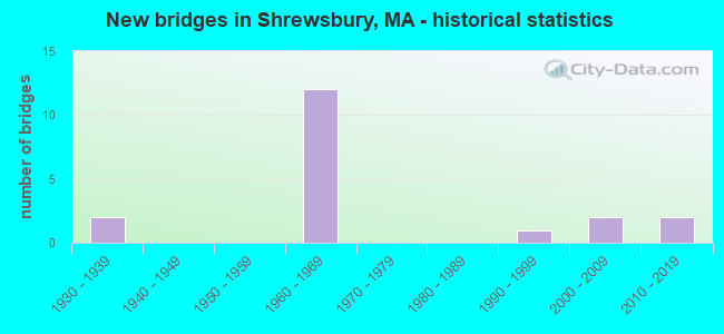
- New bridges - historical statistics
- 21930-1939
- 121960-1969
- 11990-1999
- 22000-2009
- 22010-2019


- Bridge Condition - Deck
- 7.1%Very good
- 35.7%Good
- 42.9%Satisfactory
- 14.3%Fair

- Bridge Condition - Superstructure
- 17.6%Very good
- 35.3%Good
- 35.3%Satisfactory
- 5.9%Fair
- 5.9%Poor

- Bridge Condition - Substructure
- 11.8%Very good
- 35.3%Good
- 17.6%Satisfactory
- 35.3%Fair

- Bridge Condition - Channel
- 87.5%Good
- 12.5%Satisfactory
Find on map >> Show street view
Structure Number: S14001BEWDOTNBI, Location: 100 F.T. E. OF LAKE AVE. (Lat: 42.274372, Lng: -71.755153), Route carried "on" structure: State highway 9, Year Built: 2016, Status: Open, Structure Length: 26.91m (88.29ft), Average Daily Traffic: 29,900 (year 2016), Truck Traffic: 4%, Design Load: HL 93, Features Intersected: WATER LAKE QUINSIGAMOND
Minimum Vertical Clearance: 30+ m (98+ ft), Kilometerpoint: 159.723, Lanes on structure: 4, Owner: State Highway Agency, Approaching Roadway Width: 14.6m (47.9ft), Material/Design: Steel continuous, Design/Construction: Arch - Deck, Number Of Spans In Main Unit: 5, Length of Maximum Span: 73.2m (240.2ft), Curb or Sidewalk Widths: Left: 0.0m, Right: 2.1m (6.9ft), Curb-To-Curb Width: 14.6m (47.9ft), Out-to-Out Width: 18.0m (59.1ft)
Condition: Deck: Good, Superstructure: Good, Substructure: Good, Channel: Good, Operating Rating: 48.6 metric tons, Method Used To Determine Operating Rating: Load and Resistance Factor Rating (LRFR) rating reported by rating factor(RF) method using HL-93 loadings, Inventory Rating: 38.9 metric tons, Method Used To Determine Inventory Rating: Load and Resistance Factor Rating (LRFR) rating reported by rating factor(RF) method using HL-93 loadings, Structural Evaluation: Better than present minimum criteria, Deck Geometry: High priority of replacement, Waterway Adequacy: Superior to present desirable criteria, Approach Roadway Alignment: Equal to present desirable criteria, Designated Inspection Frequency: Every 24 months, Critical Feature Inspection Frequency: Every 24 months, Underwater Inspection Frequency: Every 36 months, Inspection Date: March 2020, Critical Feature Inspection Date: March 2020, Underwater Inspection Date: June 2019, Deck Structure Type: Concrete Cast-file-Place, Wearing Surface/Protective System: Wearing Surface: Bituminous, Membrane: Epoxy, Deck Protection: Epoxy Coated Reinforcing
Find on map >> Show street view
Structure Number: S14001BL6DOTNBI, Location: 100 F.T. E. OF LAKE AVE. (Lat: 42.274294, Lng: -71.755153), Route carried "on" structure: State highway 9, Year Built: 2015, Status: Open, Structure Length: 26.51m (86.98ft), Average Daily Traffic: 27,700 (year 2016), Truck Traffic: 1%, Design Load: HL 93, Features Intersected: WATER LAKE QUINSIGAMOND
Minimum Vertical Clearance: 30+ m (98+ ft), Kilometerpoint: 159.723, Lanes on structure: 4, Owner: State Highway Agency, Approaching Roadway Width: 14.6m (47.9ft), Material/Design: Steel continuous, Design/Construction: Arch - Deck, Length of Maximum Span: 73.2m (240.2ft), Curb or Sidewalk Widths: Left: 0.0m, Right: 2.1m (6.9ft), Curb-To-Curb Width: 14.6m (47.9ft), Out-to-Out Width: 19.2m (63.0ft)
Condition: Deck: Good, Superstructure: Good, Substructure: Good, Channel: Good, Operating Rating: 51.8 metric tons, Method Used To Determine Operating Rating: Load and Resistance Factor Rating (LRFR) rating reported by rating factor(RF) method using HL-93 loadings, Inventory Rating: 38.9 metric tons, Method Used To Determine Inventory Rating: Load and Resistance Factor Rating (LRFR) rating reported by rating factor(RF) method using HL-93 loadings, Structural Evaluation: Better than present minimum criteria, Deck Geometry: High priority of replacement, Waterway Adequacy: Superior to present desirable criteria, Approach Roadway Alignment: Equal to present desirable criteria, Designated Inspection Frequency: Every 24 months, Critical Feature Inspection Frequency: Every 24 months, Underwater Inspection Frequency: Every 36 months, Inspection Date: March 2020, Critical Feature Inspection Date: March 2020, Underwater Inspection Date: June 2019, Deck Structure Type: Concrete Cast-file-Place, Wearing Surface/Protective System: Wearing Surface: Bituminous, Membrane: Epoxy, Deck Protection: Epoxy Coated Reinforcing
Find on map >> Show street view
Structure Number: S140071M0DOTNBI, Location: ST 9/ST 140 (Lat: 42.276847, Lng: -71.710558), Route carried "on" structure: State highway 9, Year Built: 1932, Status: Open, Structure Length: 1.22m (4.00ft), Average Daily Traffic: 50,103 (year 2017), Truck Traffic: 10%, Average Future Daily Traffic: 71,384 (year 2031), Design Load: H 20, Features Intersected: ST140 GRAFTON ST
Minimum Vertical Clearance: 30+ m (98+ ft), Kilometerpoint: 163.634, Lanes on structure: 4, Lanes under structure: 2, Base Highway Network: Yes, Owner: State Highway Agency, Approaching Roadway Width: 21.3m (69.9ft), Skew: 20 degrees, Material/Design: Concrete, Design/Construction: Tee Beam, Number Of Spans In Main Unit: 1, Length of Maximum Span: 9.4m (30.8ft), Curb or Sidewalk Widths: Left: 0.2m (0.7ft), Right: 0.2m (0.7ft), Curb-To-Curb Width: 21.3m (69.9ft), Out-to-Out Width: 22.6m (74.1ft)
Condition: Deck: Fair, Superstructure: Fair, Substructure: Good, Operating Rating: 49.3 metric tons, Method Used To Determine Operating Rating: Load Factor (LF), Inventory Rating: 29.5 metric tons, Method Used To Determine Inventory Rating: Load Factor (LF), Structural Evaluation: Somewhat better than minimum adequacy, Deck Geometry: Superior to present desirable criteria, Underclear: High priority of corrective action, Approach Roadway Alignment: Equal to present desirable criteria, Length Of Structure Improvement: 1.30m (4.27ft), Designated Inspection Frequency: Every 24 months, Inspection Date: July 2020, Bridge Improvement Cost: $1,155,000, Roadway Improvement Cost: $116,000, Total Project Cost: $1,733,000 ( Estimate for 2022), Deck Structure Type: Concrete Cast-file-Place, Wearing Surface/Protective System: Wearing Surface: Bituminous, Membrane: Built-up
Find on map >> Show street view
Structure Number: S14008AGMDOTNBI, Location: 1.5 MI. E. OF ST-122 (Lat: 42.246956, Lng: -71.729925), Route carried "on" structure: US 20, Year Built: 2001, Status: Open, Structure Length: 2.97m (9.74ft), Average Daily Traffic: 30,537 (year 2018), Truck Traffic: 15%, Average Future Daily Traffic: 63,172 (year 2032), Design Load: HS 20, Features Intersected: WATER FLINT POND
Minimum Vertical Clearance: 30+ m (98+ ft), Kilometerpoint: 186.647, Lanes on structure: 2, Base Highway Network: Yes, Owner: State Highway Agency, Approaching Roadway Width: 13.4m (44.0ft), Material/Design: Prestressed concrete, Design/Construction: Stringer/Multi-beam, Number Of Spans In Main Unit: 1, Length of Maximum Span: 28.2m (92.5ft), Curb or Sidewalk Widths: Left: 2.7m (8.9ft), Right: 2.7m (8.9ft), Curb-To-Curb Width: 13.4m (44.0ft), Out-to-Out Width: 19.7m (64.6ft)
Condition: Deck: Good, Superstructure: Very good, Substructure: Very good, Channel: Good, Operating Rating: 61.3 metric tons, Method Used To Determine Operating Rating: Load Factor (LF), Inventory Rating: 36.7 metric tons, Method Used To Determine Inventory Rating: Load Factor (LF), Structural Evaluation: Equal to present desirable criteria, Deck Geometry: Equal to present minimum criteria, Waterway Adequacy: Equal to present desirable criteria, Approach Roadway Alignment: Equal to present desirable criteria, Designated Inspection Frequency: Every 24 months, Inspection Date: September 2021, Deck Structure Type: Concrete Cast-file-Place, Wearing Surface/Protective System: Wearing Surface: Bituminous, Membrane: Built-up, Deck Protection: Epoxy Coated Reinforcing
Find on map >> Show street view
Structure Number: S14009B74MUNNBI, Location: .45 MI S OF US-20 (Lat: 42.256569, Lng: -71.690294), Route carried "on" structure: City street , Year Built: 2004, Status: Open, Structure Length: 1.15m (3.77ft), Average Daily Traffic: 4,647 (year 2018), Truck Traffic: 2%, Average Future Daily Traffic: 790 (year 2032), Design Load: HS 20, Features Intersected: WATER PRATTS POND INLET, Facility Carried by Structure: HWY CENTECH BLVD
Minimum Vertical Clearance: 99.00m (324.80ft), Kilometerpoint: 0.250, Lanes on structure: 2, Owner: Town or Township Highway Agency, Approaching Roadway Width: 10.9m (35.8ft), Material/Design: Steel, Design/Construction: Arch - Deck, Number Of Spans In Main Unit: 1, Number Of Approach Spans: 1, Length of Maximum Span: 11.5m (37.7ft), Curb or Sidewalk Widths: Left: 1.8m (5.9ft), Right: 0.0m, Curb-To-Curb Width: 10.9m (35.8ft), Out-to-Out Width: 21.9m (71.9ft)
Condition: Superstructure: Poor, Substructure: Very good, Channel: Good, Structural Evaluation: Meets minimum limits, Deck Geometry: Somewhat better than minimum adequacy, Waterway Adequacy: Superior to present desirable criteria, Approach Roadway Alignment: Equal to present desirable criteria, Length Of Structure Improvement: 1.20m (3.94ft), Designated Inspection Frequency: Every 12 months, Other Special Inspection Frequency: Every 12 months, Inspection Date: July 2021, Other Special Inspection Date: July 2021, Bridge Improvement Cost: $1,033,000, Roadway Improvement Cost: $104,000, Total Project Cost: $1,550,000 ( Estimate for 2022), Deck Structure Type: Corrugated Steel, Wearing Surface/Protective System: Wearing Surface: Bituminous, Membrane: Built-up
Find on map >> Show street view
Structure Number: S140121D7MUNNBI, Location: .2 MI. N. OF I-290 (Lat: 42.297856, Lng: -71.754106), Route carried "on" structure: City street , Year Built: 1939, Year Reconstructed: 1993, Status: Open, Structure Length: 0.73m (2.40ft), Average Daily Traffic: 21,580 (year 2014), Truck Traffic: 6%, Average Future Daily Traffic: 34,081 (year 2031), Design Load: HS 20, Features Intersected: WATER LAKE QUINSIGAMOND, Facility Carried by Structure: HWY W MAIN ST
Minimum Vertical Clearance: 30+ m (98+ ft), Kilometerpoint: 0.435, Lanes on structure: 4, Owner: Town or Township Highway Agency, Approaching Roadway Width: 15.8m (51.8ft), Skew: 1 degrees, Material/Design: Concrete, Design/Construction: Arch - Deck, Number Of Spans In Main Unit: 1, Length of Maximum Span: 7.3m (24.0ft), Curb or Sidewalk Widths: Left: 1.5m (4.9ft), Right: 1.5m (4.9ft), Curb-To-Curb Width: 15.8m (51.8ft), Out-to-Out Width: 19.8m (65.0ft)
Condition: Superstructure: Good, Substructure: Satisfactory, Channel: Good, Inventory Rating: 70.9 metric tons, Method Used To Determine Inventory Rating: Load Factor (LF), Structural Evaluation: Equal to present minimum criteria, Deck Geometry: Meets minimum limits, Waterway Adequacy: Equal to present desirable criteria, Approach Roadway Alignment: Equal to present desirable criteria, Length Of Structure Improvement: 0.80m (2.62ft), Designated Inspection Frequency: Every 24 months, Underwater Inspection Frequency: Every 36 months, Inspection Date: May 2020, Underwater Inspection Date: May 2020, Bridge Improvement Cost: $340,000, Roadway Improvement Cost: $35,000, Total Project Cost: $511,000 ( Estimate for 2022)
Find on map >> Show street view
Structure Number: S140151YGDOTNBI, Location: 1 MI S OF ST-9 (Lat: 42.250206, Lng: -71.711536), Route carried "on" structure: State highway 140, Year Built: 1966, Status: Open, Structure Length: 3.57m (11.71ft), Average Daily Traffic: 10,958 (year 2020), Truck Traffic: 6%, Average Future Daily Traffic: 15,793 (year 2032), Design Load: H 20, Features Intersected: US 20 HARTFORD TNPK
Minimum Vertical Clearance: 6.10m (20.01ft), Kilometerpoint: 114.086, Lanes on structure: 2, Lanes under structure: 2, Owner: State Highway Agency, Approaching Roadway Width: 13.4m (44.0ft), Material/Design: Steel, Design/Construction: Stringer/Multi-beam, Number Of Spans In Main Unit: 3, Length of Maximum Span: 18.3m (60.0ft), Curb or Sidewalk Widths: Left: 1.7m (5.6ft), Right: 0.4m (1.3ft), Curb-To-Curb Width: 13.4m (44.0ft), Out-to-Out Width: 16.5m (54.1ft)
Condition: Deck: Satisfactory, Superstructure: Satisfactory, Substructure: Fair, Operating Rating: 52.9 metric tons, Method Used To Determine Operating Rating: Load Factor (LF), Inventory Rating: 31.7 metric tons, Method Used To Determine Inventory Rating: Load Factor (LF), Structural Evaluation: Somewhat better than minimum adequacy, Deck Geometry: Equal to present minimum criteria, Underclear: High priority of corrective action, Approach Roadway Alignment: Equal to present desirable criteria, Length Of Structure Improvement: 3.60m (11.81ft), Designated Inspection Frequency: Every 24 months, Inspection Date: June 2021, Bridge Improvement Cost: $2,334,000, Roadway Improvement Cost: $234,000, Total Project Cost: $3,502,000 ( Estimate for 2022), Deck Structure Type: Concrete Cast-file-Place, Wearing Surface/Protective System: Wearing Surface: Bituminous, Membrane: Built-up
Find on map >> Show street view
Structure Number: S140171RGDOTNBI, Location: I-290 MM 11.9 (Lat: 42.311528, Lng: -71.730367), Route carried "on" structure: Interstate 290, Year Built: 1967, Status: Open, Structure Length: 2.62m (8.60ft), Average Daily Traffic: 40,500 (year 2018), Truck Traffic: 15%, Average Future Daily Traffic: 58,861 (year 2033), Design Load: HS 20+Mod, Features Intersected: HWY GULF ST
Minimum Vertical Clearance: 30+ m (98+ ft), Kilometerpoint: 19.154, Lanes on structure: 3, Lanes under structure: 2, Base Highway Network: Yes, Owner: State Highway Agency, Approaching Roadway Width: 15.2m (49.9ft), Skew: 2 degrees, Material/Design: Steel, Design/Construction: Stringer/Multi-beam, Number Of Spans In Main Unit: 1, Length of Maximum Span: 24.7m (81.0ft), Curb-To-Curb Width: 15.2m (49.9ft), Out-to-Out Width: 17.1m (56.1ft)
Condition: Deck: Satisfactory, Superstructure: Satisfactory, Substructure: Satisfactory, Operating Rating: 63.2 metric tons, Method Used To Determine Operating Rating: Load Factor (LF), Inventory Rating: 37.9 metric tons, Method Used To Determine Inventory Rating: Load Factor (LF), Structural Evaluation: Equal to present minimum criteria, Deck Geometry: Meets minimum limits, Underclear: High priority of corrective action, Approach Roadway Alignment: Equal to present desirable criteria, Length Of Structure Improvement: 2.70m (8.86ft), Designated Inspection Frequency: Every 24 months, Inspection Date: January 2022, Bridge Improvement Cost: $815,000, Roadway Improvement Cost: $82,000, Total Project Cost: $1,223,000 ( Estimate for 2022), Deck Structure Type: Concrete Cast-file-Place, Wearing Surface/Protective System: Wearing Surface: Bituminous, Membrane: Built-up
Find on map >> Show street view
Structure Number: S140171RHDOTNBI, Location: 1 MI W OF ST-140 (Lat: 42.312147, Lng: -71.731086), Route carried "on" structure: Interstate 290, Year Built: 1967, Status: Open, Structure Length: 2.53m (8.30ft), Average Daily Traffic: 43,286 (year 2018), Truck Traffic: 7%, Average Future Daily Traffic: 58,861 (year 2033), Design Load: HS 20+Mod, Features Intersected: HWY GULF ST
Minimum Vertical Clearance: 30+ m (98+ ft), Kilometerpoint: 19.154, Lanes on structure: 3, Lanes under structure: 2, Base Highway Network: Yes, Owner: State Highway Agency, Approaching Roadway Width: 15.2m (49.9ft), Skew: 2 degrees, Material/Design: Steel, Design/Construction: Stringer/Multi-beam, Number Of Spans In Main Unit: 1, Length of Maximum Span: 23.8m (78.1ft), Curb-To-Curb Width: 15.2m (49.9ft), Out-to-Out Width: 17.1m (56.1ft)
Condition: Deck: Satisfactory, Superstructure: Satisfactory, Substructure: Good, Operating Rating: 63.2 metric tons, Method Used To Determine Operating Rating: Load Factor (LF), Inventory Rating: 37.9 metric tons, Method Used To Determine Inventory Rating: Load Factor (LF), Structural Evaluation: Equal to present minimum criteria, Deck Geometry: Meets minimum limits, Underclear: High priority of corrective action, Approach Roadway Alignment: Equal to present desirable criteria, Length Of Structure Improvement: 2.60m (8.53ft), Designated Inspection Frequency: Every 24 months, Inspection Date: January 2022, Bridge Improvement Cost: $785,000, Roadway Improvement Cost: $79,000, Total Project Cost: $1,178,000 ( Estimate for 2022), Deck Structure Type: Concrete Cast-file-Place, Wearing Surface/Protective System: Wearing Surface: Bituminous, Membrane: Built-up
Find on map >> Show street view
Structure Number: S140181YHDOTNBI, Location: 1.8 MI. N. OF MAIN ST. (Lat: 42.321492, Lng: -71.719178), Route carried "on" structure: State highway 140, Year Built: 1967, Year Reconstructed: 2021, Status: Open, Structure Length: 7.95m (26.08ft), Average Daily Traffic: 13,205 (year 2020), Truck Traffic: 6%, Average Future Daily Traffic: 23,690 (year 2033), Design Load: HL 93, Features Intersected: I 290
Minimum Vertical Clearance: 30+ m (98+ ft), Kilometerpoint: 122.130, Lanes on structure: 4, Lanes under structure: 8, Owner: State Highway Agency, Approaching Roadway Width: 9.8m (32.2ft), Skew: 21 degrees, Material/Design: Steel continuous, Design/Construction: Stringer/Multi-beam, Number Of Spans In Main Unit: 2, Length of Maximum Span: 38.8m (127.3ft), Curb or Sidewalk Widths: Left: 2.9m (9.5ft), Right: 1.6m (5.2ft), Curb-To-Curb Width: 9.9m (32.5ft), Out-to-Out Width: 26.9m (88.3ft)
Condition: Deck: Very good, Superstructure: Very good, Substructure: Good, Operating Rating: 45.3 metric tons, Method Used To Determine Operating Rating: Load Factor (LF), Inventory Rating: 27.1 metric tons, Method Used To Determine Inventory Rating: Load Factor (LF), Structural Evaluation: Equal to present minimum criteria, Deck Geometry: High priority of replacement, Underclear: High priority of corrective action, Approach Roadway Alignment: Equal to present desirable criteria, Designated Inspection Frequency: Every 24 months, Inspection Date: November 2021, Deck Structure Type: Concrete Cast-file-Place, Wearing Surface/Protective System: Wearing Surface: Bituminous, Membrane: Other, Deck Protection: Epoxy Coated Reinforcing
Find on map >> Show street view
Structure Number: S140211RADOTNBI, Location: I-290 MM 10 (Lat: 42.293667, Lng: -71.757183), Route carried "on" structure: Interstate 290, Year Built: 1968, Status: Open, Structure Length: 25.76m (84.51ft), Average Daily Traffic: 37,700 (year 2019), Truck Traffic: 7%, Average Future Daily Traffic: 66,331 (year 2031), Design Load: HS 20+Mod, Features Intersected: COMB LK QUINSIG&LK AV N
Minimum Vertical Clearance: 30+ m (98+ ft), Kilometerpoint: 15.864, Lanes on structure: 3, Lanes under structure: 2, Base Highway Network: Yes, Owner: State Highway Agency, Approaching Roadway Width: 15.5m (50.9ft), Skew: 1 degrees, Material/Design: Steel continuous, Design/Construction: Stringer/Multi-beam, Number Of Spans In Main Unit: 3, Number Of Approach Spans: 1, Length of Maximum Span: 104.2m (341.9ft), Curb-To-Curb Width: 15.5m (50.9ft), Out-to-Out Width: 17.1m (56.1ft)
Condition: Deck: Satisfactory, Superstructure: Satisfactory, Substructure: Fair, Channel: Good, Operating Rating: 60.5 metric tons, Method Used To Determine Operating Rating: Load Factor (LF), Inventory Rating: 36.3 metric tons, Method Used To Determine Inventory Rating: Load Factor (LF), Structural Evaluation: Somewhat better than minimum adequacy, Deck Geometry: Somewhat better than minimum adequacy, Underclear: Meets minimum limits, Waterway Adequacy: Superior to present desirable criteria, Approach Roadway Alignment: Superior to present desirable criteria, Length Of Structure Improvement: 25.80m (84.65ft), Designated Inspection Frequency: Every 24 months, Underwater Inspection Frequency: Every 36 months, Inspection Date: August 2020, Underwater Inspection Date: September 2020, Bridge Improvement Cost: $17,330,000, Roadway Improvement Cost: $1,734,000, Total Project Cost: $25,996,000 ( Estimate for 2022), Deck Structure Type: Concrete Cast-file-Place, Wearing Surface/Protective System: Wearing Surface: Bituminous, Membrane: Built-up
Find on map >> Show street view
Structure Number: S140211RBDOTNBI, Location: .1 MI W OF W MAIN ST (Lat: 42.293847, Lng: -71.757406), Route carried "on" structure: Interstate 290, Year Built: 1969, Status: Open, Structure Length: 25.76m (84.51ft), Average Daily Traffic: 41,273 (year 2019), Truck Traffic: 15%, Average Future Daily Traffic: 66,331 (year 2031), Design Load: HS 20+Mod, Features Intersected: COMB LK QUINSIG&LK AV N
Minimum Vertical Clearance: 30+ m (98+ ft), Kilometerpoint: 15.864, Lanes on structure: 3, Lanes under structure: 2, Base Highway Network: Yes, Owner: State Highway Agency, Approaching Roadway Width: 15.5m (50.9ft), Skew: 11 degrees, Material/Design: Steel continuous, Design/Construction: Stringer/Multi-beam, Number Of Spans In Main Unit: 3, Number Of Approach Spans: 1, Length of Maximum Span: 104.2m (341.9ft), Curb or Sidewalk Widths: Left: 0.2m (0.7ft), Right: 0.2m (0.7ft), Curb-To-Curb Width: 15.5m (50.9ft), Out-to-Out Width: 17.1m (56.1ft)
Condition: Deck: Fair, Superstructure: Good, Substructure: Fair, Channel: Good, Operating Rating: 60.5 metric tons, Method Used To Determine Operating Rating: Load Factor (LF), Inventory Rating: 36.3 metric tons, Method Used To Determine Inventory Rating: Load Factor (LF), Structural Evaluation: Somewhat better than minimum adequacy, Deck Geometry: Somewhat better than minimum adequacy, Underclear: Meets minimum limits, Waterway Adequacy: Equal to present desirable criteria, Approach Roadway Alignment: Equal to present desirable criteria, Length Of Structure Improvement: 25.80m (84.65ft), Designated Inspection Frequency: Every 24 months, Underwater Inspection Frequency: Every 36 months, Inspection Date: August 2020, Underwater Inspection Date: September 2020, Bridge Improvement Cost: $17,330,000, Roadway Improvement Cost: $1,734,000, Total Project Cost: $25,996,000 ( Estimate for 2022), Deck Structure Type: Concrete Cast-file-Place, Wearing Surface/Protective System: Wearing Surface: Bituminous, Membrane: Built-up
Find on map >> Show street view
Structure Number: S140221RCDOTNBI, Location: 1.5 MI.NTH.OF ST.9 (Lat: 42.294244, Lng: -71.753736), Route carried "on" structure: Interstate 290, Year Built: 1968, Status: Open, Structure Length: 2.71m (8.89ft), Average Daily Traffic: 34,146 (year 2020), Truck Traffic: 8%, Average Future Daily Traffic: 134,240 (year 2032), Design Load: HS 20+Mod, Features Intersected: HWY N QUINSIGAMOND AVE
Minimum Vertical Clearance: 30+ m (98+ ft), Kilometerpoint: 16.093, Lanes on structure: 3, Lanes under structure: 2, Base Highway Network: Yes, Owner: State Highway Agency, Approaching Roadway Width: 15.2m (49.9ft), Material/Design: Steel, Design/Construction: Stringer/Multi-beam, Number Of Spans In Main Unit: 1, Length of Maximum Span: 25.6m (84.0ft), Curb-To-Curb Width: 16.3m (53.5ft), Out-to-Out Width: 17.1m (56.1ft)
Condition: Deck: Good, Superstructure: Satisfactory, Substructure: Fair, Operating Rating: 54.7 metric tons, Method Used To Determine Operating Rating: Load Factor (LF), Inventory Rating: 32.8 metric tons, Method Used To Determine Inventory Rating: Load Factor (LF), Structural Evaluation: Somewhat better than minimum adequacy, Deck Geometry: Equal to present minimum criteria, Underclear: High priority of corrective action, Approach Roadway Alignment: Equal to present desirable criteria, Length Of Structure Improvement: 2.80m (9.19ft), Designated Inspection Frequency: Every 24 months, Inspection Date: October 2021, Bridge Improvement Cost: $1,881,000, Roadway Improvement Cost: $189,000, Total Project Cost: $2,822,000 ( Estimate for 2022), Deck Structure Type: Concrete Cast-file-Place, Wearing Surface/Protective System: Wearing Surface: Bituminous, Membrane: Built-up
Find on map >> Show street view
Structure Number: S140221RDDOTNBI, Location: 1.5 MI.NTH.OF ST.9 (Lat: 42.294542, Lng: -71.753769), Route carried "on" structure: Interstate 290, Year Built: 1968, Status: Open, Structure Length: 2.71m (8.89ft), Average Daily Traffic: 40,864 (year 2018), Truck Traffic: 7%, Average Future Daily Traffic: 134,240 (year 2032), Design Load: H 20, Features Intersected: HWY N QUINSIGAMOND AVE
Minimum Vertical Clearance: 30+ m (98+ ft), Kilometerpoint: 0.000, Lanes on structure: 3, Lanes under structure: 2, Base Highway Network: Yes, Owner: State Highway Agency, Approaching Roadway Width: 15.7m (51.5ft), Material/Design: Steel, Design/Construction: Stringer/Multi-beam, Number Of Spans In Main Unit: 1, Length of Maximum Span: 25.6m (84.0ft), Curb-To-Curb Width: 15.7m (51.5ft), Out-to-Out Width: 17.1m (56.1ft)
Condition: Deck: Satisfactory, Superstructure: Satisfactory, Substructure: Satisfactory, Operating Rating: 57.2 metric tons, Method Used To Determine Operating Rating: Load Factor (LF), Inventory Rating: 34.3 metric tons, Method Used To Determine Inventory Rating: Load Factor (LF), Structural Evaluation: Equal to present minimum criteria, Deck Geometry: Somewhat better than minimum adequacy, Underclear: High priority of corrective action, Approach Roadway Alignment: Equal to present desirable criteria, Length Of Structure Improvement: 2.80m (9.19ft), Designated Inspection Frequency: Every 24 months, Inspection Date: October 2021, Bridge Improvement Cost: $713,000, Roadway Improvement Cost: $72,000, Total Project Cost: $1,070,000 ( Estimate for 2022), Deck Structure Type: Concrete Cast-file-Place, Wearing Surface/Protective System: Wearing Surface: Bituminous, Membrane: Built-up
Find on map >> Show street view
Structure Number: S140231REDOTNBI, Location: 0.4 MI E OF WORC TL (Lat: 42.294844, Lng: -71.750797), Route carried "on" structure: Interstate 290, Year Built: 1968, Status: Open, Structure Length: 4.53m (14.86ft), Average Daily Traffic: 30,050 (year 2020), Truck Traffic: 8%, Average Future Daily Traffic: 55,276 (year 2033), Design Load: HS 20+Mod, Features Intersected: HWY W MAIN ST
Minimum Vertical Clearance: 30+ m (98+ ft), Kilometerpoint: 0.000, Lanes on structure: 3, Lanes under structure: 5, Base Highway Network: Yes, Owner: State Highway Agency, Approaching Roadway Width: 16.3m (53.5ft), Skew: 1 degrees, Material/Design: Steel continuous, Design/Construction: Stringer/Multi-beam, Number Of Spans In Main Unit: 2, Length of Maximum Span: 22.7m (74.5ft), Curb-To-Curb Width: 16.3m (53.5ft), Out-to-Out Width: 17.7m (58.1ft)
Condition: Deck: Good, Superstructure: Good, Substructure: Fair, Operating Rating: 57.6 metric tons, Method Used To Determine Operating Rating: Load Factor (LF), Inventory Rating: 34.5 metric tons, Method Used To Determine Inventory Rating: Load Factor (LF), Structural Evaluation: Somewhat better than minimum adequacy, Deck Geometry: Equal to present minimum criteria, Underclear: High priority of corrective action, Approach Roadway Alignment: Equal to present desirable criteria, Length Of Structure Improvement: 4.60m (15.09ft), Designated Inspection Frequency: Every 24 months, Inspection Date: March 2022, Bridge Improvement Cost: $3,199,000, Roadway Improvement Cost: $320,000, Total Project Cost: $4,799,000 ( Estimate for 2022), Deck Structure Type: Concrete Cast-file-Place, Wearing Surface/Protective System: Wearing Surface: Bituminous, Membrane: Built-up
Find on map >> Show street view
Structure Number: S140231RFDOTNBI, Location: .4 MI. EAST OF WORC T.L. (Lat: 42.295142, Lng: -71.751028), Route carried "on" structure: Interstate 290, Year Built: 1968, Status: Open, Structure Length: 4.53m (14.86ft), Average Daily Traffic: 35,161 (year 2020), Truck Traffic: 7%, Average Future Daily Traffic: 55,276 (year 2033), Design Load: HS 20+Mod, Features Intersected: HWY W MAIN ST
Minimum Vertical Clearance: 30+ m (98+ ft), Kilometerpoint: 16.544, Lanes on structure: 4, Lanes under structure: 4, Base Highway Network: Yes, Owner: State Highway Agency, Approaching Roadway Width: 16.3m (53.5ft), Skew: 1 degrees, Material/Design: Steel continuous, Design/Construction: Stringer/Multi-beam, Number Of Spans In Main Unit: 2, Length of Maximum Span: 22.7m (74.5ft), Curb-To-Curb Width: 16.3m (53.5ft), Out-to-Out Width: 17.7m (58.1ft)
Condition: Deck: Satisfactory, Superstructure: Good, Substructure: Fair, Operating Rating: 55.1 metric tons, Method Used To Determine Operating Rating: Load Factor (LF), Inventory Rating: 33.0 metric tons, Method Used To Determine Inventory Rating: Load Factor (LF), Structural Evaluation: Somewhat better than minimum adequacy, Deck Geometry: High priority of replacement, Underclear: High priority of corrective action, Approach Roadway Alignment: Equal to present desirable criteria, Length Of Structure Improvement: 4.60m (15.09ft), Designated Inspection Frequency: Every 24 months, Inspection Date: March 2022, Bridge Improvement Cost: $3,204,000, Roadway Improvement Cost: $321,000, Total Project Cost: $4,807,000 ( Estimate for 2022), Deck Structure Type: Concrete Cast-file-Place, Wearing Surface/Protective System: Wearing Surface: Bituminous, Membrane: Built-up
Find on map >> Show street view
Structure Number: S14025AEXMUNNBI, Location: 500 FT N OF RESERVOIR ST (Lat: 42.325281, Lng: -71.697825), Route carried "on" structure: City street , Year Built: 1990, Status: Open, Structure Length: 1.22m (4.00ft), Average Daily Traffic: 200 (year 2016), Truck Traffic: 1%, Average Future Daily Traffic: 316 (year 2033), Features Intersected: WATER RAWSON HILL BROOK, Facility Carried by Structure: HWY BOWDOIN ST
Minimum Vertical Clearance: 30+ m (98+ ft), Kilometerpoint: 0.161, Lanes on structure: 2, Owner: Town or Township Highway Agency, Approaching Roadway Width: 7.3m (24.0ft), Material/Design: Concrete, Design/Construction: Arch - Deck, Number Of Spans In Main Unit: 1, Length of Maximum Span: 12.2m (40.0ft), Curb or Sidewalk Widths: Left: 1.4m (4.6ft), Right: 1.4m (4.6ft), Curb-To-Curb Width: 7.3m (24.0ft), Out-to-Out Width: 15.2m (49.9ft)
Condition: Superstructure: Very good, Substructure: Good, Channel: Satisfactory, Operating Rating: 50.9 metric tons, Method Used To Determine Operating Rating: Load Factor (LF), Inventory Rating: 29.5 metric tons, Method Used To Determine Inventory Rating: Load Factor (LF), Structural Evaluation: Better than present minimum criteria, Deck Geometry: Somewhat better than minimum adequacy, Waterway Adequacy: Equal to present desirable criteria, Approach Roadway Alignment: Equal to present desirable criteria, Length Of Structure Improvement: 1.30m (4.27ft), Designated Inspection Frequency: Every 24 months, Inspection Date: Febuary 2022, Bridge Improvement Cost: $777,000, Roadway Improvement Cost: $78,000, Total Project Cost: $1,166,000 ( Estimate for 2022)
Find on map >> Show street view
Structure Number: S140181YHDOTNBI, Location: ST 140/I 290 (Lat: 42.316667, Lng: -71.716667), Route carried "under" structure: Interstate 290, Year Built: 1967, Structure Length: 0. m, Average Daily Traffic: 27,000 (year 0000), Features Intersected: I 290 EB, Facility Carried by Structure: ST140
Minimum Vertical Clearance: 5.05m (16.57ft), Kilometerpoint: 0.000, Lanes on structure: 3, Lanes under structure: 4, Material/Design: Steel, Design/Construction: Stringer/Multi-beam, Length of Maximum Span: 39.0m (128.0ft)
Find on map >> Show street view
Structure Number: S140181YHDOTNBI, Location: ST 140/I 290 (Lat: 42.316667, Lng: -71.716667), Route carried "under" structure: Interstate 290, Year Built: 1967, Structure Length: 0. m, Average Daily Traffic: 27,000 (year 0000), Features Intersected: I 290 WB, Facility Carried by Structure: ST140
Minimum Vertical Clearance: 5.05m (16.57ft), Kilometerpoint: 0.000, Lanes on structure: 3, Lanes under structure: 4, Material/Design: Steel, Design/Construction: Stringer/Multi-beam, Length of Maximum Span: 39.0m (128.0ft)