Bridge Statistics for Shiloh, Pennsylvania (PA)
Condition, Traffic, Stress, Structural Evaluation, Project Costs
- National Bridge Inventory (NBI) Statistics
- 25Number of bridges
- 148ft / 45.1mTotal length
- $5,782,000Total costs
- 220,552Total average daily traffic
- 27,277Total average daily truck traffic
- National Bridge Inventory (NBI) Registered Bridges for Shiloh
- No street view available for this location
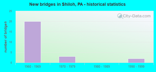
- New bridges - historical statistics
- 201960-1969
- 31970-1979
- 21990-1999


- Bridge Condition - Deck
- 10.0%Very good
- 60.0%Good
- 30.0%Satisfactory

- Bridge Condition - Superstructure
- 20.0%Good
- 60.0%Satisfactory
- 20.0%Fair

- Bridge Condition - Substructure
- 10.0%Good
- 60.0%Satisfactory
- 30.0%Fair

- Bridge Condition - Channel
- 50.0%Good
- 50.0%Fair

- Bridge Condition - Culverts
- 50.0%Satisfactory
- 50.0%Fair
Find on map >> Show street view
Structure Number: 37356, Location: 2 MI. S.W. OF WEST YORK (Lat: 39.937031, Lng: -76.798433), Route carried "on" structure: US 30, Year Built: 1969, Status: Open, Structure Length: 4.69m (15.39ft), Average Daily Traffic: 16,159 (year 2020), Truck Traffic: 17%, Average Future Daily Traffic: 23,657 (year 2032), Design Load: HS 20, Features Intersected: US 30; SR 0030, Facility Carried by Structure: PA 462 E.B.
Minimum Vertical Clearance: 30+ m (98+ ft), Kilometerpoint: 15.989, Lanes on structure: 3, Lanes under structure: 16, Base Highway Network: Yes, Owner: State Highway Agency, Approaching Roadway Width: 19.5m (64.0ft), Skew: 10 degrees, Material/Design: Prestressed concrete, Design/Construction: Box Beam or Girders - Single/Spread, Number Of Spans In Main Unit: 2, Length of Maximum Span: 23.2m (76.1ft), Curb or Sidewalk Widths: Left: 0.2m (0.7ft), Right: 0.2m (0.7ft), Curb-To-Curb Width: 18.1m (59.4ft), Out-to-Out Width: 19.4m (63.6ft)
Condition: Deck: Good, Superstructure: Satisfactory, Substructure: Fair, Operating Rating: 55.3 metric tons, Method Used To Determine Operating Rating: Load Factor (LF), Inventory Rating: 28.1 metric tons, Method Used To Determine Inventory Rating: Load Factor (LF), Structural Evaluation: Somewhat better than minimum adequacy, Deck Geometry: Superior to present desirable criteria, Underclear: High priority of corrective action, Approach Roadway Alignment: Equal to present desirable criteria, Length Of Structure Improvement: 5.60m (18.37ft), Designated Inspection Frequency: Every 24 months, Inspection Date: September 2021, Bridge Improvement Cost: $82,000, Roadway Improvement Cost: $240,000, Total Project Cost: $1,101,000, Deck Structure Type: Concrete Cast-file-Place, Wearing Surface/Protective System: Wearing Surface: Latex Concrete
Find on map >> Show street view
Structure Number: 37357, Location: 2 MI. S.W. OF WEST YORK (Lat: 39.937131, Lng: -76.798717), Route carried "on" structure: US 30, Year Built: 1969, Status: Open, Structure Length: 4.75m (15.58ft), Average Daily Traffic: 16,579 (year 2020), Truck Traffic: 18%, Average Future Daily Traffic: 23,905 (year 2032), Design Load: HS 20, Features Intersected: US 30; SR 0030, Facility Carried by Structure: West Market Street
Minimum Vertical Clearance: 30+ m (98+ ft), Kilometerpoint: 15.989, Lanes on structure: 2, Lanes under structure: 8, Base Highway Network: Yes, Owner: State Highway Agency, Approaching Roadway Width: 13.4m (44.0ft), Skew: 10 degrees, Material/Design: Prestressed concrete, Design/Construction: Box Beam or Girders - Single/Spread, Number Of Spans In Main Unit: 2, Length of Maximum Span: 23.2m (76.1ft), Curb or Sidewalk Widths: Left: 0.2m (0.7ft), Right: 0.2m (0.7ft), Curb-To-Curb Width: 12.2m (40.0ft), Out-to-Out Width: 13.4m (44.0ft)
Condition: Deck: Satisfactory, Superstructure: Satisfactory, Substructure: Fair, Operating Rating: 67.1 metric tons, Method Used To Determine Operating Rating: Load Factor (LF), Inventory Rating: 23.6 metric tons, Method Used To Determine Inventory Rating: Load Factor (LF), Structural Evaluation: Somewhat better than minimum adequacy, Deck Geometry: Better than present minimum criteria, Underclear: Meets minimum limits, Approach Roadway Alignment: Equal to present desirable criteria, Length Of Structure Improvement: 5.70m (18.70ft), Designated Inspection Frequency: Every 24 months, Inspection Date: September 2021, Deck Structure Type: Concrete Cast-file-Place, Wearing Surface/Protective System: Wearing Surface: Latex Concrete
Find on map >> Show street view
Structure Number: 37358, Location: .2 MILE NORTH OF LR126 (Lat: 39.939531, Lng: -76.800206), Route carried "on" structure: US 30, Year Built: 1969, Status: Open, Structure Length: 1.07m (3.51ft), Average Daily Traffic: 14,636 (year 2021), Truck Traffic: 14%, Average Future Daily Traffic: 44,327 (year 2032), Design Load: HS 20, Features Intersected: York Rail
Minimum Vertical Clearance: 30+ m (98+ ft), Kilometerpoint: 16.953, Lanes on structure: 6, Base Highway Network: Yes, Owner: State Highway Agency, Approaching Roadway Width: 43.6m (143.0ft), Skew: 20 degrees, Material/Design: Concrete, Design/Construction: Frame, Number Of Spans In Main Unit: 1, Length of Maximum Span: 9.4m (30.8ft), Curb or Sidewalk Widths: Left: 0.2m (0.7ft), Right: 0.2m (0.7ft), Curb-To-Curb Width: 42.3m (138.8ft), Out-to-Out Width: 43.2m (141.7ft)
Condition: Deck: Good, Superstructure: Good, Substructure: Satisfactory, Operating Rating: 49.0 metric tons, Method Used To Determine Operating Rating: Load Factor (LF), Inventory Rating: 29.0 metric tons, Method Used To Determine Inventory Rating: Load Factor (LF), Structural Evaluation: Equal to present minimum criteria, Deck Geometry: Superior to present desirable criteria, Underclear: High priority of corrective action, Approach Roadway Alignment: Equal to present desirable criteria, Length Of Structure Improvement: 1.80m (5.91ft), Designated Inspection Frequency: Every 24 months, Inspection Date: August 2021
Find on map >> Show street view
Structure Number: 37359, Location: 1 MI N OF LR126 (Lat: 39.949872, Lng: -76.793194), Route carried "on" structure: US 30, Year Built: 1969, Status: Open, Structure Length: 5.06m (16.60ft), Average Daily Traffic: 13,407 (year 2021), Truck Traffic: 12%, Average Future Daily Traffic: 21,322 (year 2032), Design Load: HS 20, Features Intersected: RR/PRIVATE ACCESS RD
Minimum Vertical Clearance: 30+ m (98+ ft), Kilometerpoint: 18.631, Lanes on structure: 2, Base Highway Network: Yes, Owner: State Highway Agency, Approaching Roadway Width: 13.4m (44.0ft), Skew: 12 degrees, Material/Design: Prestressed concrete, Design/Construction: Box Beam or Girders - Single/Spread, Number Of Spans In Main Unit: 3, Length of Maximum Span: 21.6m (70.9ft), Curb or Sidewalk Widths: Left: 0.2m (0.7ft), Right: 0.2m (0.7ft), Curb-To-Curb Width: 12.2m (40.0ft), Out-to-Out Width: 13.4m (44.0ft)
Condition: Deck: Good, Superstructure: Satisfactory, Substructure: Satisfactory, Operating Rating: 75.3 metric tons, Method Used To Determine Operating Rating: Load Factor (LF), Inventory Rating: 30.8 metric tons, Method Used To Determine Inventory Rating: Load Factor (LF), Structural Evaluation: Equal to present minimum criteria, Deck Geometry: Better than present minimum criteria, Underclear: High priority of corrective action, Approach Roadway Alignment: Equal to present desirable criteria, Length Of Structure Improvement: 5.90m (19.36ft), Designated Inspection Frequency: Every 24 months, Inspection Date: August 2021, Bridge Improvement Cost: $60,000, Roadway Improvement Cost: $176,000, Total Project Cost: $808,000, Deck Structure Type: Concrete Cast-file-Place, Wearing Surface/Protective System: Wearing Surface: Latex Concrete
Find on map >> Show street view
Structure Number: 3736, Location: 1 MILE NORTH OF 462 (Lat: 39.949972, Lng: -76.793419), Route carried "on" structure: US 30, Year Built: 1969, Status: Open, Structure Length: 5.06m (16.60ft), Average Daily Traffic: 1,229 (year 2021), Truck Traffic: 30%, Average Future Daily Traffic: 23,005 (year 2032), Design Load: HS 20, Features Intersected: RR/PRIVATE ACCESS RD
Minimum Vertical Clearance: 30+ m (98+ ft), Kilometerpoint: 18.667, Lanes on structure: 2, Base Highway Network: Yes, Owner: State Highway Agency, Approaching Roadway Width: 13.4m (44.0ft), Skew: 12 degrees, Material/Design: Prestressed concrete, Design/Construction: Box Beam or Girders - Single/Spread, Number Of Spans In Main Unit: 3, Length of Maximum Span: 21.6m (70.9ft), Curb or Sidewalk Widths: Left: 0.2m (0.7ft), Right: 0.2m (0.7ft), Curb-To-Curb Width: 12.2m (40.0ft), Out-to-Out Width: 13.4m (44.0ft)
Condition: Deck: Satisfactory, Superstructure: Satisfactory, Substructure: Satisfactory, Operating Rating: 52.6 metric tons, Method Used To Determine Operating Rating: Load Factor (LF), Inventory Rating: 30.8 metric tons, Method Used To Determine Inventory Rating: Load Factor (LF), Structural Evaluation: Equal to present minimum criteria, Deck Geometry: Better than present minimum criteria, Underclear: High priority of corrective action, Approach Roadway Alignment: Equal to present desirable criteria, Length Of Structure Improvement: 6.00m (19.69ft), Designated Inspection Frequency: Every 24 months, Inspection Date: August 2021, Bridge Improvement Cost: $61,000, Roadway Improvement Cost: $180,000, Total Project Cost: $825,000, Deck Structure Type: Concrete Cast-file-Place, Wearing Surface/Protective System: Wearing Surface: Latex Concrete
Find on map >> Show street view
Structure Number: 37361, Location: 1.8 MI NORTH OF LR126 (Lat: 39.958006, Lng: -76.785144), Route carried "on" structure: US 30, Year Built: 1969, Status: Open, Structure Length: 3.87m (12.70ft), Average Daily Traffic: 13,407 (year 2021), Truck Traffic: 12%, Average Future Daily Traffic: 21,322 (year 2032), Design Load: HS 20, Features Intersected: GREENWOOD RD; T-825
Minimum Vertical Clearance: 30+ m (98+ ft), Kilometerpoint: 19.782, Lanes on structure: 2, Lanes under structure: 2, Base Highway Network: Yes, Owner: State Highway Agency, Approaching Roadway Width: 13.4m (44.0ft), Skew: 11 degrees, Material/Design: Prestressed concrete, Design/Construction: Box Beam or Girders - Single/Spread, Number Of Spans In Main Unit: 3, Length of Maximum Span: 15.8m (51.8ft), Curb or Sidewalk Widths: Left: 0.2m (0.7ft), Right: 0.2m (0.7ft), Curb-To-Curb Width: 12.2m (40.0ft), Out-to-Out Width: 13.4m (44.0ft)
Condition: Deck: Satisfactory, Superstructure: Fair, Substructure: Satisfactory, Operating Rating: 78.0 metric tons, Method Used To Determine Operating Rating: Load Factor (LF), Inventory Rating: 32.7 metric tons, Method Used To Determine Inventory Rating: Load Factor (LF), Structural Evaluation: Somewhat better than minimum adequacy, Deck Geometry: Better than present minimum criteria, Underclear: Superior to present desirable criteria, Approach Roadway Alignment: Equal to present desirable criteria, Length Of Structure Improvement: 4.70m (15.42ft), Designated Inspection Frequency: Every 24 months, Inspection Date: September 2021, Bridge Improvement Cost: $48,000, Roadway Improvement Cost: $140,000, Total Project Cost: $643,000, Deck Structure Type: Concrete Cast-file-Place, Wearing Surface/Protective System: Wearing Surface: Monolithic Concrete
Find on map >> Show street view
Structure Number: 37362, Location: 2 MI NORTH OF LR126 (Lat: 39.961150, Lng: -76.781686), Route carried "on" structure: US 30, Year Built: 1969, Status: Open, Structure Length: 3.44m (11.29ft), Average Daily Traffic: 14,636 (year 2021), Truck Traffic: 14%, Average Future Daily Traffic: 44,327 (year 2032), Design Load: HS 20, Features Intersected: T-813 TAXVILLE RD
Minimum Vertical Clearance: 30+ m (98+ ft), Kilometerpoint: 19.782, Lanes on structure: 4, Lanes under structure: 2, Base Highway Network: Yes, Owner: State Highway Agency, Approaching Roadway Width: 28.0m (91.9ft), Skew: 31 degrees, Material/Design: Prestressed concrete, Design/Construction: Box Beam or Girders - Single/Spread, Number Of Spans In Main Unit: 3, Length of Maximum Span: 14.3m (46.9ft), Curb or Sidewalk Widths: Left: 0.2m (0.7ft), Right: 0.2m (0.7ft), Curb-To-Curb Width: 26.8m (87.9ft), Out-to-Out Width: 28.0m (91.9ft)
Condition: Deck: Good, Superstructure: Satisfactory, Substructure: Satisfactory, Operating Rating: 75.3 metric tons, Method Used To Determine Operating Rating: Load Factor (LF), Inventory Rating: 28.1 metric tons, Method Used To Determine Inventory Rating: Load Factor (LF), Structural Evaluation: Equal to present minimum criteria, Deck Geometry: Superior to present desirable criteria, Underclear: Equal to present minimum criteria, Approach Roadway Alignment: Equal to present desirable criteria, Length Of Structure Improvement: 4.30m (14.11ft), Designated Inspection Frequency: Every 24 months, Inspection Date: September 2021, Bridge Improvement Cost: $91,000, Roadway Improvement Cost: $268,000, Total Project Cost: $1,229,000, Deck Structure Type: Concrete Cast-file-Place, Wearing Surface/Protective System: Wearing Surface: Monolithic Concrete
Find on map >> Show street view
Structure Number: 37363, Location: 1.8 MI NORTH OF LR126 (Lat: 39.958100, Lng: -76.785336), Route carried "on" structure: US 30, Year Built: 1969, Status: Open, Structure Length: 3.87m (12.70ft), Average Daily Traffic: 1,229 (year 2021), Truck Traffic: 30%, Average Future Daily Traffic: 23,005 (year 2032), Design Load: HS 20, Features Intersected: GREENWOOD RD; T-825
Minimum Vertical Clearance: 30+ m (98+ ft), Kilometerpoint: 19.824, Lanes on structure: 2, Lanes under structure: 2, Base Highway Network: Yes, Owner: State Highway Agency, Approaching Roadway Width: 13.4m (44.0ft), Skew: 11 degrees, Material/Design: Prestressed concrete, Design/Construction: Box Beam or Girders - Multiple, Number Of Spans In Main Unit: 1, Number Of Approach Spans: 2, Length of Maximum Span: 15.8m (51.8ft), Curb or Sidewalk Widths: Left: 0.2m (0.7ft), Right: 0.2m (0.7ft), Curb-To-Curb Width: 13.4m (44.0ft), Out-to-Out Width: 13.4m (44.0ft)
Condition: Deck: Good, Superstructure: Fair, Substructure: Fair, Operating Rating: 83.5 metric tons, Method Used To Determine Operating Rating: Load Factor (LF), Inventory Rating: 39.9 metric tons, Method Used To Determine Inventory Rating: Load Factor (LF), Structural Evaluation: Somewhat better than minimum adequacy, Deck Geometry: Superior to present desirable criteria, Underclear: Equal to present minimum criteria, Approach Roadway Alignment: Equal to present desirable criteria, Length Of Structure Improvement: 4.70m (15.42ft), Designated Inspection Frequency: Every 24 months, Inspection Date: September 2021, Bridge Improvement Cost: $15,000, Roadway Improvement Cost: $43,000, Total Project Cost: $198,000, Deck Structure Type: Concrete Cast-file-Place, Wearing Surface/Protective System: Wearing Surface: Monolithic Concrete
Find on map >> Show street view
Structure Number: 37364, Location: 2.7 MI NORTH OF LR126 (Lat: 39.965125, Lng: -76.771403), Route carried "on" structure: US 30, Year Built: 1969, Status: Open, Structure Length: 4.94m (16.21ft), Average Daily Traffic: 41,996 (year 2020), Truck Traffic: 12%, Average Future Daily Traffic: 58,968 (year 2032), Design Load: HS 20, Features Intersected: PA 74; SR 0074
Minimum Vertical Clearance: 30+ m (98+ ft), Kilometerpoint: 21.208, Lanes on structure: 4, Lanes under structure: 8, Base Highway Network: Yes, Owner: State Highway Agency, Approaching Roadway Width: 26.8m (87.9ft), Skew: 31 degrees, Material/Design: Prestressed concrete, Design/Construction: Box Beam or Girders - Multiple, Number Of Spans In Main Unit: 1, Number Of Approach Spans: 2, Length of Maximum Span: 29.6m (97.1ft), Curb or Sidewalk Widths: Left: 0.2m (0.7ft), Right: 0.2m (0.7ft), Curb-To-Curb Width: 25.3m (83.0ft), Out-to-Out Width: 27.7m (90.9ft)
Condition: Deck: Good, Superstructure: Good, Substructure: Good, Operating Rating: 77.1 metric tons, Method Used To Determine Operating Rating: Load Factor (LF), Inventory Rating: 30.8 metric tons, Method Used To Determine Inventory Rating: Load Factor (LF), Structural Evaluation: Better than present minimum criteria, Deck Geometry: Superior to present desirable criteria, Underclear: Meets minimum limits, Approach Roadway Alignment: Equal to present desirable criteria, Length Of Structure Improvement: 5.90m (19.36ft), Designated Inspection Frequency: Every 24 months, Inspection Date: September 2021, Bridge Improvement Cost: $46,000, Roadway Improvement Cost: $136,000, Total Project Cost: $622,000, Deck Structure Type: Concrete Cast-file-Place, Wearing Surface/Protective System: Wearing Surface: Monolithic Concrete
Find on map >> Show street view
Structure Number: 37554, Location: INTERSECTION OF LR 1070 (Lat: 39.947833, Lng: -76.795761), Route carried "on" structure: State highway 234, Year Built: 1971, Status: Open, Structure Length: 6.55m (21.49ft), Average Daily Traffic: 7,417 (year 2022), Truck Traffic: 9%, Average Future Daily Traffic: 7,859 (year 2032), Design Load: HS 20, Features Intersected: US 30; SR 0030
Minimum Vertical Clearance: 30+ m (98+ ft), Kilometerpoint: 14.684, Lanes on structure: 2, Lanes under structure: 8, Owner: State Highway Agency, Approaching Roadway Width: 11.0m (36.1ft), Skew: 4 degrees, Material/Design: Prestressed concrete, Design/Construction: Stringer/Multi-beam, Number Of Spans In Main Unit: 2, Length of Maximum Span: 31.4m (103.0ft), Curb or Sidewalk Widths: Left: 0.2m (0.7ft), Right: 0.2m (0.7ft), Curb-To-Curb Width: 13.4m (44.0ft), Out-to-Out Width: 14.6m (47.9ft)
Condition: Deck: Very good, Superstructure: Satisfactory, Substructure: Satisfactory, Operating Rating: 89.8 metric tons, Method Used To Determine Operating Rating: Load Factor (LF), Inventory Rating: 21.8 metric tons, Method Used To Determine Inventory Rating: Load Factor (LF), Structural Evaluation: Somewhat better than minimum adequacy, Deck Geometry: Equal to present minimum criteria, Underclear: High priority of corrective action, Approach Roadway Alignment: Equal to present desirable criteria, Length Of Structure Improvement: 7.70m (25.26ft), Designated Inspection Frequency: Every 24 months, Inspection Date: September 2021, Bridge Improvement Cost: $26,000, Roadway Improvement Cost: $78,000, Total Project Cost: $356,000, Deck Structure Type: Concrete Cast-file-Place, Wearing Surface/Protective System: Wearing Surface: Latex Concrete
Find on map >> Show street view
Structure Number: 57184, Location: At int w/Derry Rd (Lat: 39.965556, Lng: -76.804444), Route carried "on" structure: City street , Year Built: 1990, Status: Open, Structure Length: 0.67m (2.20ft), Average Daily Traffic: 200 (year 2019), Truck Traffic: 1%, Average Future Daily Traffic: 244 (year 2039), Design Load: HS 25 or greater, Features Intersected: Trib to Little Conewago, Facility Carried by Structure: Loman Ave
Minimum Vertical Clearance: 30+ m (98+ ft), Kilometerpoint: 0.000, Lanes on structure: 2, Owner: Town or Township Highway Agency, Approaching Roadway Width: 9.8m (32.2ft), Material/Design: Concrete, Design/Construction: Culvert, Number Of Spans In Main Unit: 2, Length of Maximum Span: 3.0m (9.8ft), Curb or Sidewalk Widths: Left: 2.9m (9.5ft), Right: 2.2m (7.2ft)
Condition: Channel: Good, Culverts: Fair, Operating Rating: 48.1 metric tons, Method Used To Determine Operating Rating: Field evaluation and documented engineering judgment, Inventory Rating: 28.1 metric tons, Method Used To Determine Inventory Rating: Field evaluation and documented engineering judgment, Structural Evaluation: Somewhat better than minimum adequacy, Waterway Adequacy: Better than present minimum criteria, Approach Roadway Alignment: Equal to present desirable criteria, Designated Inspection Frequency: Every 24 months, Inspection Date: July 2020
Find on map >> Show street view
Structure Number: 68128, Location: 250' N OF MARTINGALE DR (Lat: 39.997972, Lng: -76.783389), Route carried "on" structure: City street , Year Built: 1993, Status: Open, Structure Length: 1.16m (3.81ft), Average Daily Traffic: 100 (year 2021), Average Future Daily Traffic: 120 (year 2040), Features Intersected: TRIB TO LITTLE CONEWAGO, Facility Carried by Structure: HAMBILTONIAN WAY
Minimum Vertical Clearance: 30+ m (98+ ft), Kilometerpoint: 0.000, Lanes on structure: 2, Owner: Town or Township Highway Agency, Approaching Roadway Width: 9.8m (32.2ft), Skew: 3 degrees, Material/Design: Concrete, Design/Construction: Culvert, Number Of Spans In Main Unit: 3, Length of Maximum Span: 3.7m (12.1ft)
Condition: Channel: Fair, Culverts: Satisfactory, Operating Rating: 49.0 metric tons, Method Used To Determine Operating Rating: Field evaluation and documented engineering judgment, Inventory Rating: 32.7 metric tons, Method Used To Determine Inventory Rating: Field evaluation and documented engineering judgment, Structural Evaluation: Equal to present minimum criteria, Waterway Adequacy: Better than present minimum criteria, Approach Roadway Alignment: Equal to present desirable criteria, Designated Inspection Frequency: Every 24 months, Inspection Date: March 2021
Find on map >> Show street view
Structure Number: 37356, Location: 2 MI. S.W. OF WEST YORK (Lat: 39.937031, Lng: -76.798433), Route carried "under" structure: Ramp State highway , Year Built: 1969, Structure Length: 0. m, Average Daily Traffic: 1,685 (year 2022), Truck Traffic: 7%, Features Intersected: US 30; SR 0030, Facility Carried by Structure: PA 462 E.B.
Minimum Vertical Clearance: 5.39m (17.68ft), Kilometerpoint: 0.000, Lanes on structure: 3, Lanes under structure: 4, Material/Design: Prestressed concrete, Design/Construction: Box Beam or Girders - Single/Spread, Length of Maximum Span: 23.2m (76.1ft)
Find on map >> Show street view
Structure Number: 37356, Location: 2 MI. S.W. OF WEST YORK (Lat: 39.937031, Lng: -76.798433), Route carried "under" structure: Ramp State highway , Year Built: 1969, Structure Length: 0. m, Average Daily Traffic: 12,862 (year 2022), Truck Traffic: 7%, Features Intersected: US 30; SR 0030, Facility Carried by Structure: PA 462 E.B.
Minimum Vertical Clearance: 4.72m (15.49ft), Kilometerpoint: 0.000, Lanes on structure: 3, Lanes under structure: 4, Material/Design: Prestressed concrete, Design/Construction: Box Beam or Girders - Single/Spread, Length of Maximum Span: 23.2m (76.1ft)
Find on map >> Show street view
Structure Number: 37356, Location: 2 MI. S.W. OF WEST YORK (Lat: 39.937031, Lng: -76.798433), Route carried "under" structure: Ramp US 30, Year Built: 1969, Structure Length: 0. m, Average Daily Traffic: 13,407 (year 2021), Truck Traffic: 12%, Features Intersected: US 30; SR 0030, Facility Carried by Structure: PA 462 E.B.
Minimum Vertical Clearance: 4.72m (15.49ft), Kilometerpoint: 16.953, Lanes on structure: 3, Lanes under structure: 4, Material/Design: Prestressed concrete, Design/Construction: Box Beam or Girders - Single/Spread, Length of Maximum Span: 23.2m (76.1ft)
Find on map >> Show street view
Structure Number: 37356, Location: 2 MI. S.W. OF WEST YORK (Lat: 39.937031, Lng: -76.798433), Route carried "under" structure: Ramp US 30, Year Built: 1969, Structure Length: 0. m, Average Daily Traffic: 1,229 (year 2021), Truck Traffic: 30%, Features Intersected: US 30; SR 0030, Facility Carried by Structure: PA 462 E.B.
Minimum Vertical Clearance: 5.39m (17.68ft), Kilometerpoint: 16.942, Lanes on structure: 3, Lanes under structure: 4, Material/Design: Prestressed concrete, Design/Construction: Box Beam or Girders - Single/Spread, Length of Maximum Span: 23.2m (76.1ft)
Find on map >> Show street view
Structure Number: 37357, Location: 2 MI. S.W. OF WEST YORK (Lat: 39.937131, Lng: -76.798717), Route carried "under" structure: US 30, Year Built: 1969, Structure Length: 0. m, Average Daily Traffic: 1,229 (year 2021), Truck Traffic: 30%, Features Intersected: US 30; SR 0030, Facility Carried by Structure: West Market Street
Minimum Vertical Clearance: 5.58m (18.31ft), Kilometerpoint: 16.942, Lanes on structure: 2, Lanes under structure: 4, Material/Design: Prestressed concrete, Design/Construction: Box Beam or Girders - Single/Spread, Length of Maximum Span: 23.2m (76.1ft)
Find on map >> Show street view
Structure Number: 37357, Location: 2 MI. S.W. OF WEST YORK (Lat: 39.937131, Lng: -76.798717), Route carried "under" structure: US 30, Year Built: 1969, Structure Length: 0. m, Average Daily Traffic: 13,407 (year 2021), Truck Traffic: 12%, Features Intersected: US 30; SR 0030, Facility Carried by Structure: West Market Street
Minimum Vertical Clearance: 5.03m (16.50ft), Kilometerpoint: 16.953, Lanes on structure: 2, Lanes under structure: 4, Material/Design: Prestressed concrete, Design/Construction: Box Beam or Girders - Single/Spread, Length of Maximum Span: 23.2m (76.1ft)
Find on map >> Show street view
Structure Number: 37361, Location: 1.8 MI NORTH OF LR126 (Lat: 39.958006, Lng: -76.785144), Route carried "under" structure: City street , Year Built: 1969, Structure Length: 0. m, Average Daily Traffic: 1 (year 2003), Features Intersected: GREENWOOD RD; T-825, Facility Carried by Structure: US 30; SR 0030
Minimum Vertical Clearance: 5.61m (18.41ft), Kilometerpoint: 0.000, Lanes on structure: 2, Lanes under structure: 2, Material/Design: Prestressed concrete, Design/Construction: Box Beam or Girders - Single/Spread, Length of Maximum Span: 15.8m (51.8ft)
Find on map >> Show street view
Structure Number: 37362, Location: 2 MI NORTH OF LR126 (Lat: 39.961150, Lng: -76.781686), Route carried "under" structure: City street , Year Built: 1969, Structure Length: 0. m, Average Daily Traffic: 1 (year 2003), Features Intersected: T-813 TAXVILLE RD, Facility Carried by Structure: US 30; SR 0030
Minimum Vertical Clearance: 4.50m (14.76ft), Kilometerpoint: 0.000, Lanes on structure: 4, Lanes under structure: 2, Material/Design: Prestressed concrete, Design/Construction: Box Beam or Girders - Single/Spread, Length of Maximum Span: 14.3m (46.9ft)
Find on map >> Show street view
Structure Number: 37363, Location: 1.8 MI NORTH OF LR126 (Lat: 39.958100, Lng: -76.785336), Route carried "under" structure: City street , Year Built: 1969, Structure Length: 0. m, Average Daily Traffic: 1 (year 2003), Features Intersected: GREENWOOD RD; T-825, Facility Carried by Structure: US 30; SR 0030
Minimum Vertical Clearance: 4.42m (14.50ft), Kilometerpoint: 0.000, Lanes on structure: 2, Lanes under structure: 2, Material/Design: Prestressed concrete, Design/Construction: Box Beam or Girders - Multiple, Length of Maximum Span: 15.8m (51.8ft)
Find on map >> Show street view
Structure Number: 37364, Location: 2.7 MI NORTH OF LR126 (Lat: 39.965125, Lng: -76.771403), Route carried "under" structure: State highway 74, Year Built: 1969, Structure Length: 0. m, Average Daily Traffic: 10,734 (year 2020), Truck Traffic: 4%, Features Intersected: PA 74; SR 0074, Facility Carried by Structure: US 30; SR 0030
Minimum Vertical Clearance: 4.65m (15.26ft), Kilometerpoint: 52.460, Lanes on structure: 4, Lanes under structure: 4, Material/Design: Prestressed concrete, Design/Construction: Box Beam or Girders - Multiple, Length of Maximum Span: 29.6m (97.1ft)
Find on map >> Show street view
Structure Number: 37364, Location: 2.7 MI NORTH OF LR126 (Lat: 39.965125, Lng: -76.771403), Route carried "under" structure: State highway 74, Year Built: 1969, Structure Length: 0. m, Average Daily Traffic: 10,365 (year 2020), Truck Traffic: 4%, Features Intersected: PA 74; SR 0074, Facility Carried by Structure: US 30; SR 0030
Minimum Vertical Clearance: 4.47m (14.67ft), Kilometerpoint: 52.463, Lanes on structure: 4, Lanes under structure: 4, Material/Design: Prestressed concrete, Design/Construction: Box Beam or Girders - Multiple, Length of Maximum Span: 29.6m (97.1ft)
Find on map >> Show street view
Structure Number: 37554, Location: INTERSECTION OF LR 1070 (Lat: 39.947833, Lng: -76.795761), Route carried "under" structure: US 30, Year Built: 1971, Structure Length: 0. m, Average Daily Traffic: 1,229 (year 2021), Truck Traffic: 30%, Features Intersected: US 30; SR 0030, Facility Carried by Structure: PA 234; SR 0234
Minimum Vertical Clearance: 5.11m (16.77ft), Kilometerpoint: 18.050, Lanes on structure: 2, Lanes under structure: 4, Material/Design: Prestressed concrete, Design/Construction: Stringer/Multi-beam, Length of Maximum Span: 31.4m (103.0ft)
Find on map >> Show street view
Structure Number: 37554, Location: INTERSECTION OF LR 1070 (Lat: 39.947833, Lng: -76.795761), Route carried "under" structure: US 30, Year Built: 1971, Structure Length: 0. m, Average Daily Traffic: 13,407 (year 2021), Truck Traffic: 12%, Features Intersected: US 30; SR 0030, Facility Carried by Structure: PA 234; SR 0234
Minimum Vertical Clearance: 4.62m (15.16ft), Kilometerpoint: 18.112, Lanes on structure: 2, Lanes under structure: 4, Material/Design: Prestressed concrete, Design/Construction: Stringer/Multi-beam, Length of Maximum Span: 31.4m (103.0ft)