Bridge Statistics for Shiloh, Illinois (IL)
Condition, Traffic, Stress, Structural Evaluation, Project Costs
- National Bridge Inventory (NBI) Statistics
- 13Number of bridges
- 92ft / 27.7mTotal length
- $1,523,000Total costs
- 161,050Total average daily traffic
- 14,775Total average daily truck traffic
- National Bridge Inventory (NBI) Registered Bridges for Shiloh
- No street view available for this location
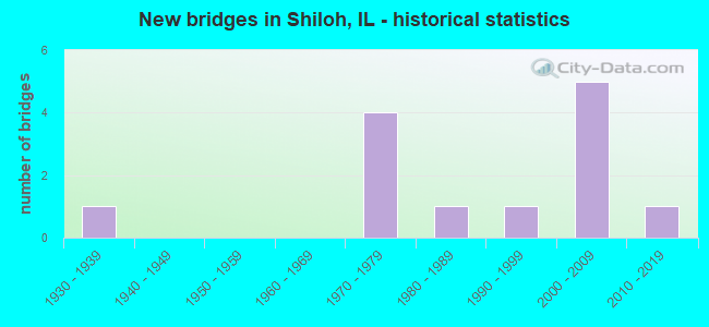
- New bridges - historical statistics
- 11930-1939
- 41970-1979
- 11980-1989
- 11990-1999
- 52000-2009
- 12010-2019

- Reconstructed bridges - Historical Statistics
- 11970-1979
- 01980-1989
- 21990-1999
- 12000-2009


- Bridge Condition - Deck
- 16.7%Very good
- 66.7%Good
- 16.7%Fair

- Bridge Condition - Superstructure
- 33.3%Very good
- 50.0%Good
- 16.7%Fair

- Bridge Condition - Substructure
- 33.3%Very good
- 50.0%Good
- 16.7%Satisfactory

- Bridge Condition - Channel
- 16.7%Excellent
- 33.3%Very good
- 16.7%Good
- 33.3%Satisfactory

- Bridge Condition - Culverts
- 50.0%Very good
- 50.0%Good
Find on map >> Show street view
Structure Number: 820182, Location: 1/2 mi S of US 50 (Lat: 38.574439, Lng: -89.886681), Route carried "on" structure: Other road , Year Built: 1972, Year Reconstructed: 2005, Status: Open, Structure Length: 6.01m (19.72ft), Average Daily Traffic: 5,050 (year 2018), Truck Traffic: 6%, Average Future Daily Traffic: 4,550 (year 2032), Design Load: HS 20, Features Intersected: FAI 64, Facility Carried by Structure: N Main St / FAU 92
Minimum Vertical Clearance: 30+ m (98+ ft), Kilometerpoint: 11.120, Lanes on structure: 2, Lanes under structure: 4, Base Highway Network: Yes, Owner: State Highway Agency, Approaching Roadway Width: 13.4m (44.0ft), Material/Design: Steel continuous, Design/Construction: Stringer/Multi-beam, Number Of Spans In Main Unit: 2, Number Of Approach Spans: 2, Length of Maximum Span: 29.7m (97.4ft), Curb-To-Curb Width: 13.0m (42.7ft), Out-to-Out Width: 14.0m (45.9ft)
Condition: Deck: Good, Superstructure: Good, Substructure: Good, Operating Rating: 70.3 metric tons, Method Used To Determine Operating Rating: Load Factor (LF) rating reported by rating factor (RF) method using MS18 loading, Inventory Rating: 43.7 metric tons, Method Used To Determine Inventory Rating: Load Factor (LF) rating reported by rating factor (RF) method using MS18 loading, Structural Evaluation: Better than present minimum criteria, Deck Geometry: Somewhat better than minimum adequacy, Underclear: High priority of corrective action, Approach Roadway Alignment: Equal to present desirable criteria, Designated Inspection Frequency: Every 24 months, Inspection Date: Febuary 2021, Deck Structure Type: Concrete Cast-file-Place, Wearing Surface/Protective System: Wearing Surface: Other
Find on map >> Show street view
Structure Number: 82021, Location: 0.5 MI W OF SCOTTAFB (Lat: 38.534050, Lng: -89.883789), Route carried "on" structure: State highway 158, Year Built: 1972, Year Reconstructed: 2001, Status: Open, Structure Length: 6.21m (20.37ft), Average Daily Traffic: 7,550 (year 2021), Truck Traffic: 6%, Average Future Daily Traffic: 3,687 (year 2032), Design Load: HS 20, Features Intersected: METROLNK&TRACKSDE LN
Minimum Vertical Clearance: 30+ m (98+ ft), Kilometerpoint: 36.000, Lanes on structure: 2, Lanes under structure: 2, Base Highway Network: Yes, Owner: State Highway Agency, Approaching Roadway Width: 12.2m (40.0ft), Material/Design: Steel, Design/Construction: Stringer/Multi-beam, Number Of Spans In Main Unit: 3, Length of Maximum Span: 25.0m (82.0ft), Curb-To-Curb Width: 11.7m (38.4ft), Out-to-Out Width: 12.8m (42.0ft)
Condition: Deck: Good, Superstructure: Good, Substructure: Good, Operating Rating: 68.4 metric tons, Method Used To Determine Operating Rating: Load Factor (LF) rating reported by rating factor (RF) method using MS18 loading, Inventory Rating: 36.3 metric tons, Method Used To Determine Inventory Rating: Load Factor (LF) rating reported by rating factor (RF) method using MS18 loading, Structural Evaluation: Better than present minimum criteria, Deck Geometry: Better than present minimum criteria, Underclear: Somewhat better than minimum adequacy, Approach Roadway Alignment: Equal to present desirable criteria, Designated Inspection Frequency: Every 48 months, Inspection Date: September 2020, Deck Structure Type: Concrete Cast-file-Place, Wearing Surface/Protective System: Wearing Surface: Bituminous, Membrane: Built-up
Find on map >> Show street view
Structure Number: 822007, Location: 1.22 M W OF ILL 158 (Lat: 38.519317, Lng: -89.885678), Route carried "on" structure: State highway 161, Year Built: 1933, Year Reconstructed: 1975, Status: Open, Structure Length: 0.84m (2.76ft), Average Daily Traffic: 12,200 (year 2021), Truck Traffic: 5%, Average Future Daily Traffic: 11,401 (year 2032), Design Load: H 15, Features Intersected: TRIB TO LOOP CREEK
Minimum Vertical Clearance: 30+ m (98+ ft), Kilometerpoint: 19.408, Lanes on structure: 4, Base Highway Network: Yes, Owner: State Highway Agency, Approaching Roadway Width: 20.7m (67.9ft), Skew: 1 degrees, Material/Design: Concrete continuous, Design/Construction: Culvert, Number Of Spans In Main Unit: 2, Length of Maximum Span: 3.8m (12.5ft)
Condition: Channel: Satisfactory, Culverts: Good, Operating Rating: 66.4 metric tons, Method Used To Determine Operating Rating: Load Factor (LF) rating reported by rating factor (RF) method using MS18 loading, Inventory Rating: 39.9 metric tons, Method Used To Determine Inventory Rating: Load Factor (LF) rating reported by rating factor (RF) method using MS18 loading, Structural Evaluation: Better than present minimum criteria, Waterway Adequacy: Equal to present minimum criteria, Approach Roadway Alignment: Equal to present desirable criteria, Designated Inspection Frequency: Every 24 months, Inspection Date: April 2021
Find on map >> Show street view
Structure Number: 823084, Location: 2.25 MI S LINCOLN TR (Lat: 38.558531, Lng: -89.947211), Route carried "on" structure: Other road , Year Built: 1992, Status: Open, Structure Length: 4.19m (13.75ft), Average Daily Traffic: 10,150 (year 2018), Truck Traffic: 2%, Average Future Daily Traffic: 8,368 (year 2032), Design Load: HS 20, Features Intersected: RICHLAND CREEK, Facility Carried by Structure: HARTMAN LN/ FAU 91
Minimum Vertical Clearance: 30+ m (98+ ft), Kilometerpoint: 3.766, Lanes on structure: 2, Owner: County Highway Agency, Approaching Roadway Width: 9.1m (29.9ft), Material/Design: Prestressed concrete, Design/Construction: Box Beam or Girders - Multiple, Number Of Spans In Main Unit: 3, Length of Maximum Span: 16.4m (53.8ft), Curb or Sidewalk Widths: Left: 0.0m, Right: 1.5m (4.9ft), Curb-To-Curb Width: 9.1m (29.9ft), Out-to-Out Width: 11.0m (36.1ft)
Condition: Deck: Fair, Superstructure: Fair, Substructure: Satisfactory, Channel: Very good, Operating Rating: 44.1 metric tons, Method Used To Determine Operating Rating: Assigned rating based on Load Factor Design (LFD) reported by rating factor (RF) using MS18 loading, Inventory Rating: 32.4 metric tons, Method Used To Determine Inventory Rating: Assigned rating based on Load Factor Design (LFD) reported by rating factor (RF) using MS18 loading, Structural Evaluation: Somewhat better than minimum adequacy, Deck Geometry: High priority of corrective action, Waterway Adequacy: Superior to present desirable criteria, Approach Roadway Alignment: Equal to present desirable criteria, Length Of Structure Improvement: 4.18m (13.71ft), Designated Inspection Frequency: Every 24 months, Inspection Date: Febuary 2020, Bridge Improvement Cost: $739,000, Roadway Improvement Cost: $36,000, Total Project Cost: $775,000, Deck Structure Type: Concrete Precast Panels, Wearing Surface/Protective System: Wearing Surface: Bituminous, Membrane: Built-up
Find on map >> Show street view
Structure Number: 823095, Location: 0.5 MI W CH 89 (Lat: 38.570597, Lng: -89.937353), Route carried "on" structure: Other road , Year Built: 2001, Status: Open, Structure Length: 2.94m (9.65ft), Average Daily Traffic: 15,700 (year 2018), Truck Traffic: 3%, Average Future Daily Traffic: 15,481 (year 2032), Design Load: HS 20, Features Intersected: TRIB RICHLAND CK, Facility Carried by Structure: FRANK SCOTT PKWY
Minimum Vertical Clearance: 30+ m (98+ ft), Kilometerpoint: 9.447, Lanes on structure: 2, Base Highway Network: Yes, Owner: County Highway Agency, Approaching Roadway Width: 13.2m (43.3ft), Material/Design: Steel, Design/Construction: Stringer/Multi-beam, Number Of Spans In Main Unit: 1, Length of Maximum Span: 28.2m (92.5ft), Curb-To-Curb Width: 13.2m (43.3ft), Out-to-Out Width: 14.2m (46.6ft)
Condition: Deck: Good, Superstructure: Very good, Substructure: Very good, Channel: Excellent, Operating Rating: 44.1 metric tons, Method Used To Determine Operating Rating: Assigned rating based on Load Factor Design (LFD) reported by rating factor (RF) using MS18 loading, Inventory Rating: 32.4 metric tons, Method Used To Determine Inventory Rating: Assigned rating based on Load Factor Design (LFD) reported by rating factor (RF) using MS18 loading, Structural Evaluation: Equal to present desirable criteria, Deck Geometry: Somewhat better than minimum adequacy, Waterway Adequacy: Superior to present desirable criteria, Approach Roadway Alignment: Equal to present desirable criteria, Designated Inspection Frequency: Every 48 months, Inspection Date: April 2020, Deck Structure Type: Concrete Cast-file-Place, Wearing Surface/Protective System: Deck Protection: Epoxy Coated Reinforcing
Find on map >> Show street view
Structure Number: 823097, Location: 0.2 MI WEST CH 81 (Lat: 38.570375, Lng: -89.925169), Route carried "on" structure: Other road , Year Built: 2001, Status: Open, Structure Length: 0.72m (2.36ft), Average Daily Traffic: 12,000 (year 2018), Truck Traffic: 4%, Average Future Daily Traffic: 10,146 (year 2032), Design Load: HS 20, Features Intersected: UNNAMED TRIBUTARY, Facility Carried by Structure: FRANK SCOTT PKWY W
Minimum Vertical Clearance: 30+ m (98+ ft), Kilometerpoint: 10.541, Lanes on structure: 2, Base Highway Network: Yes, Owner: County Highway Agency, Approaching Roadway Width: 13.1m (43.0ft), Material/Design: Concrete, Design/Construction: Culvert, Number Of Spans In Main Unit: 2, Length of Maximum Span: 3.0m (9.8ft), Curb-To-Curb Width: 7.3m (24.0ft), Out-to-Out Width: 7.3m (24.0ft)
Condition: Channel: Satisfactory, Culverts: Very good, Operating Rating: 44.1 metric tons, Method Used To Determine Operating Rating: Assigned rating based on Load Factor Design (LFD) reported by rating factor (RF) using MS18 loading, Inventory Rating: 32.4 metric tons, Method Used To Determine Inventory Rating: Assigned rating based on Load Factor Design (LFD) reported by rating factor (RF) using MS18 loading, Structural Evaluation: Equal to present desirable criteria, Deck Geometry: High priority of replacement, Waterway Adequacy: Superior to present desirable criteria, Approach Roadway Alignment: Equal to present desirable criteria, Designated Inspection Frequency: Every 48 months, Inspection Date: April 2020
Find on map >> Show street view
Structure Number: 824121, Location: 1.5 MI N SHILOH RD (Lat: 38.568578, Lng: -89.929067), Route carried "on" structure: Other road , Year Built: 1987, Year Reconstructed: 2002, Status: Open, Structure Length: 4.94m (16.21ft), Average Daily Traffic: 18,200 (year 2021), Truck Traffic: 3%, Average Future Daily Traffic: 17,677 (year 2032), Design Load: HS 20, Features Intersected: RICHLAND CREEK, Facility Carried by Structure: NORTH GREENMOUNT R
Minimum Vertical Clearance: 30+ m (98+ ft), Kilometerpoint: 2.655, Lanes on structure: 2, Base Highway Network: Yes, Owner: County Highway Agency, Approaching Roadway Width: 13.4m (44.0ft), Material/Design: Prestressed concrete, Design/Construction: Box Beam or Girders - Multiple, Number Of Spans In Main Unit: 3, Length of Maximum Span: 18.3m (60.0ft), Curb-To-Curb Width: 13.5m (44.3ft), Out-to-Out Width: 13.5m (44.3ft)
Condition: Deck: Good, Superstructure: Good, Substructure: Good, Channel: Very good, Operating Rating: 93.6 metric tons, Method Used To Determine Operating Rating: Load Factor (LF) rating reported by rating factor (RF) method using MS18 loading, Inventory Rating: 40.8 metric tons, Method Used To Determine Inventory Rating: Load Factor (LF) rating reported by rating factor (RF) method using MS18 loading, Structural Evaluation: Better than present minimum criteria, Deck Geometry: Superior to present desirable criteria, Waterway Adequacy: Better than present minimum criteria, Approach Roadway Alignment: Superior to present desirable criteria, Length Of Structure Improvement: 4.94m (16.21ft), Designated Inspection Frequency: Every 48 months, Inspection Date: March 2018, Bridge Improvement Cost: $680,000, Roadway Improvement Cost: $68,000, Total Project Cost: $748,000, Deck Structure Type: Concrete Precast Panels, Wearing Surface/Protective System: Wearing Surface: Bituminous, Membrane: Built-up
Find on map >> Show street view
Structure Number: 824153, Location: 1 MI N IL RTE 161 (Lat: 38.527850, Lng: -89.900275), Route carried "on" structure: Other road , Year Built: 2006, Status: Open, Structure Length: 1.89m (6.20ft), Average Daily Traffic: 850 (year 2018), Truck Traffic: 6%, Average Future Daily Traffic: 680 (year 2032), Design Load: HS 20, Features Intersected: BRANCH LOOP CREEK, Facility Carried by Structure: SHILOH STATION RD
Minimum Vertical Clearance: 30+ m (98+ ft), Kilometerpoint: 3.380, Lanes on structure: 2, Owner: Town or Township Highway Agency, Approaching Roadway Width: 6.1m (20.0ft), Skew: 1 degrees, Material/Design: Prestressed concrete, Design/Construction: Box Beam or Girders - Multiple, Number Of Spans In Main Unit: 1, Length of Maximum Span: 17.9m (58.7ft), Curb-To-Curb Width: 8.6m (28.2ft), Out-to-Out Width: 8.6m (28.2ft)
Condition: Deck: Very good, Superstructure: Very good, Substructure: Very good, Channel: Good, Operating Rating: 44.1 metric tons, Method Used To Determine Operating Rating: Assigned rating based on Load Factor Design (LFD) reported by rating factor (RF) using MS18 loading, Inventory Rating: 32.4 metric tons, Method Used To Determine Inventory Rating: Assigned rating based on Load Factor Design (LFD) reported by rating factor (RF) using MS18 loading, Structural Evaluation: Equal to present desirable criteria, Deck Geometry: Somewhat better than minimum adequacy, Waterway Adequacy: Equal to present desirable criteria, Approach Roadway Alignment: Equal to present desirable criteria, Designated Inspection Frequency: Every 48 months, Inspection Date: March 2017, Deck Structure Type: Concrete Precast Panels, Wearing Surface/Protective System: Wearing Surface: Bituminous, Membrane: Built-up
Find on map >> Show street view
Structure Number: 820182, Location: 1/2 mi S of US 50 (Lat: 38.575006, Lng: -89.886147), Route carried "under" structure: Interstate 64, Year Built: 1972, Structure Length: 0. m, Average Daily Traffic: 57,500 (year 2021), Truck Traffic: 18%, Features Intersected: FAI 64, Facility Carried by Structure: N Main St / FAU 92
Minimum Vertical Clearance: 5.13m (16.83ft), Kilometerpoint: 29.305, Lanes on structure: 2, Lanes under structure: 4, Material/Design: Steel continuous, Design/Construction: Stringer/Multi-beam, Length of Maximum Span: 29.7m (97.4ft)
Find on map >> Show street view
Structure Number: 82021, Location: 0.5 MI W OF SCOTTAFB (Lat: 38.533703, Lng: -89.883789), Route carried "under" structure: City street , Year Built: 1972, Structure Length: 0. m, Average Daily Traffic: 25 (year 2018), Features Intersected: METROLNK&TRACKSDE LN, Facility Carried by Structure: ILL 158 S.B.
Minimum Vertical Clearance: 4.60m (15.09ft), Kilometerpoint: 1.481, Lanes on structure: 2, Lanes under structure: 2, Material/Design: Steel, Design/Construction: Stringer/Multi-beam, Length of Maximum Span: 25.0m (82.0ft)
Find on map >> Show street view
Structure Number: 820345, Location: .5 MI W OF SCOT AFB (Lat: 38.533697, Lng: -89.883439), Route carried "under" structure: City street , Year Built: 2001, Structure Length: 0. m, Average Daily Traffic: 25 (year 2018), Features Intersected: METROLNK/TRACKSDE LN, Facility Carried by Structure: ILL 158 N.B.
Minimum Vertical Clearance: 4.52m (14.83ft), Kilometerpoint: 1.513, Lanes on structure: 2, Lanes under structure: 2, Material/Design: Steel continuous, Design/Construction: Stringer/Multi-beam, Length of Maximum Span: 37.5m (123.0ft)
Find on map >> Show street view
Structure Number: 827003, Location: NEAR SWIC/METRO BR (Lat: 38.519469, Lng: -89.919394), Route carried "under" structure: State highway 161, Year Built: 2014, Structure Length: 0. m, Average Daily Traffic: 10,900 (year 2021), Truck Traffic: 6%, Features Intersected: IL 161, Facility Carried by Structure: SCCTD BIKE/PED TRA
Minimum Vertical Clearance: 5.51m (18.08ft), Kilometerpoint: 16.495, Lanes under structure: 4, Material/Design: Steel continuous, Length of Maximum Span: 35.7m (117.1ft)
Find on map >> Show street view
Structure Number: 829945, Location: .48MI EAST FAU 9170 (Lat: 38.519469, Lng: -89.919394), Route carried "under" structure: State highway 161, Year Built: 2004, Structure Length: 0. m, Average Daily Traffic: 10,900 (year 2021), Truck Traffic: 6%, Features Intersected: IL 161, Facility Carried by Structure: METROLINK
Minimum Vertical Clearance: 30.40m (99.74ft), Kilometerpoint: 16.495, Lanes under structure: 4, Material/Design: Steel, Design/Construction: Stringer/Multi-beam, Length of Maximum Span: 40.8m (133.9ft)