Bridge Statistics for Sharon, Pennsylvania (PA)
Condition, Traffic, Stress, Structural Evaluation, Project Costs
- National Bridge Inventory (NBI) Statistics
- 23Number of bridges
- 249ft / 76.4mTotal length
- $7,402,000Total costs
- 134,251Total average daily traffic
- 6,206Total average daily truck traffic
- National Bridge Inventory (NBI) Registered Bridges for Sharon
- No street view available for this location
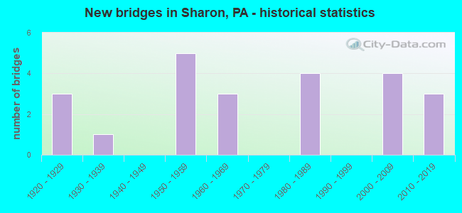
- New bridges - historical statistics
- 31920-1929
- 11930-1939
- 51950-1959
- 31960-1969
- 41980-1989
- 42000-2009
- 32010-2019

- Reconstructed bridges - Historical Statistics
- 11970-1979
- 01980-1989
- 21990-1999
- 02000-2009
- 12010-2019


- Bridge Condition - Deck
- 5.9%Very good
- 41.2%Good
- 23.5%Satisfactory
- 23.5%Fair
- 5.9%Poor

- Bridge Condition - Superstructure
- 5.9%Excellent
- 29.4%Very good
- 11.8%Satisfactory
- 29.4%Fair
- 5.9%Poor
- 17.6%Serious

- Bridge Condition - Substructure
- 23.5%Very good
- 17.6%Good
- 29.4%Fair
- 29.4%Poor

- Bridge Condition - Channel
- 6.3%Very good
- 25.0%Good
- 37.5%Satisfactory
- 25.0%Fair
- 6.3%Poor

- Bridge Condition - Culverts
- 50.0%Satisfactory
- 50.0%Fair
Find on map >> Show street view
Structure Number: 2602, Location: LC02 LICK RUN NO. 2 (Lat: 40.301422, Lng: -79.974142), Route carried "on" structure: City street , Year Built: 1920, Year Reconstructed: 1981, Status: Posted for load, Structure Length: 1.10m (3.61ft), Average Daily Traffic: 300 (year 2017), Truck Traffic: 2%, Average Future Daily Traffic: 400 (year 2037), Features Intersected: LICK RUN, Facility Carried by Structure: WALLACE RD
Minimum Vertical Clearance: 30+ m (98+ ft), Kilometerpoint: 0.000, Lanes on structure: 2, Owner: County Highway Agency, Approaching Roadway Width: 6.7m (22.0ft), Material/Design: Wood or Timber, Design/Construction: Stringer/Multi-beam, Number Of Spans In Main Unit: 1, Length of Maximum Span: 8.8m (28.9ft), Curb-To-Curb Width: 6.8m (22.3ft), Out-to-Out Width: 7.2m (23.6ft)
Condition: Deck: Satisfactory, Superstructure: Satisfactory, Substructure: Fair, Channel: Poor, Operating Rating: 31.8 metric tons, Method Used To Determine Operating Rating: Allowable Stress (AS), Inventory Rating: 20.9 metric tons, Method Used To Determine Inventory Rating: Allowable Stress (AS), Structural Evaluation: Somewhat better than minimum adequacy, Deck Geometry: Meets minimum limits, Waterway Adequacy: Equal to present desirable criteria, Approach Roadway Alignment: Somewhat better than minimum adequacy, Bridge Posting: Required (Relationship of Operating Rating to Maximum Legal Load: 30.0 - 39.9% below), Length Of Structure Improvement: 1.10m (3.61ft), Designated Inspection Frequency: Every 24 months, Other Special Inspection Frequency: Every 12 months, Inspection Date: November 2021, Other Special Inspection Date: November 2021, Deck Structure Type: Wood or Timber, Wearing Surface/Protective System: Wearing Surface: Bituminous
Find on map >> Show street view
Structure Number: 2632, Location: AB04 ABERS CREEK NO. 4 (Lat: 40.415117, Lng: -79.722342), Route carried "on" structure: City street , Year Built: 1987, Status: Open, Structure Length: 1.62m (5.31ft), Average Daily Traffic: 500 (year 2019), Truck Traffic: 1%, Average Future Daily Traffic: 700 (year 2039), Design Load: HS 20+Mod, Features Intersected: ABERS CREEK, Facility Carried by Structure: CAVITT RD
Minimum Vertical Clearance: 30+ m (98+ ft), Kilometerpoint: 0.000, Lanes on structure: 2, Owner: County Highway Agency, Approaching Roadway Width: 7.9m (25.9ft), Skew: 3 degrees, Material/Design: Prestressed concrete, Design/Construction: Box Beam or Girders - Multiple, Number Of Spans In Main Unit: 1, Length of Maximum Span: 15.8m (51.8ft), Curb or Sidewalk Widths: Left: 0.2m (0.7ft), Right: 0.2m (0.7ft), Curb-To-Curb Width: 7.9m (25.9ft), Out-to-Out Width: 9.0m (29.5ft)
Condition: Deck: Poor, Superstructure: Serious, Substructure: Poor, Channel: Satisfactory, Operating Rating: 54.4 metric tons, Method Used To Determine Operating Rating: Load Factor (LF), Inventory Rating: 21.8 metric tons, Method Used To Determine Inventory Rating: Load Factor (LF), Structural Evaluation: High priority of corrective action, Deck Geometry: Somewhat better than minimum adequacy, Waterway Adequacy: Equal to present desirable criteria, Approach Roadway Alignment: Equal to present desirable criteria, Length Of Structure Improvement: 1.70m (5.58ft), Designated Inspection Frequency: Every 24 months, Other Special Inspection Frequency: Every 12 months, Inspection Date: June 2021, Other Special Inspection Date: June 2021, Bridge Improvement Cost: $4,000, Roadway Improvement Cost: $12,000, Total Project Cost: $56,000, Deck Structure Type: Other, Wearing Surface/Protective System: Wearing Surface: Bituminous, Membrane: Preformed Fabric
Find on map >> Show street view
Structure Number: 25699, Location: CITY OF SHARON (Lat: 41.225581, Lng: -80.511372), Route carried "on" structure: US 62, Year Built: 1956, Year Reconstructed: 2010, Status: Open, Structure Length: 11.73m (38.48ft), Average Daily Traffic: 13,806 (year 2022), Truck Traffic: 5%, Average Future Daily Traffic: 12,021 (year 2032), Design Load: H 20, Features Intersected: OVER RIVERSIDE DR/RIVER
Minimum Vertical Clearance: 30+ m (98+ ft), Kilometerpoint: 0.787, Lanes on structure: 2, Lanes under structure: 1, Base Highway Network: Yes, Owner: State Highway Agency, Approaching Roadway Width: 18.3m (60.0ft), Skew: 35 degrees, Material/Design: Steel continuous, Design/Construction: Stringer/Multi-beam, Number Of Spans In Main Unit: 4, Length of Maximum Span: 31.7m (104.0ft), Curb or Sidewalk Widths: Left: 2.1m (6.9ft), Right: 2.1m (6.9ft), Curb-To-Curb Width: 18.0m (59.1ft), Out-to-Out Width: 19.8m (65.0ft)
Condition: Deck: Good, Superstructure: Fair, Substructure: Good, Channel: Good, Operating Rating: 71.7 metric tons, Method Used To Determine Operating Rating: Load and Resistance Factor (LRFR), Inventory Rating: 55.3 metric tons, Method Used To Determine Inventory Rating: Load and Resistance Factor (LRFR), Structural Evaluation: Somewhat better than minimum adequacy, Deck Geometry: Superior to present desirable criteria, Underclear: High priority of corrective action, Waterway Adequacy: Superior to present desirable criteria, Approach Roadway Alignment: Equal to present desirable criteria, Length Of Structure Improvement: 12.40m (40.68ft), Designated Inspection Frequency: Every 24 months, Underwater Inspection Frequency: Every 60 months, Inspection Date: June 2021, Underwater Inspection Date: November 2021, Bridge Improvement Cost: $419,000, Roadway Improvement Cost: $1,233,000, Total Project Cost: $5,653,000, Deck Structure Type: Concrete Cast-file-Place, Wearing Surface/Protective System: Wearing Surface: Monolithic Concrete, Deck Protection: Epoxy Coated Reinforcing
Find on map >> Show street view
Structure Number: 25702, Location: CITY OF SHARON (Lat: 41.231364, Lng: -80.498458), Route carried "on" structure: US 62, Year Built: 1955, Status: Open, Structure Length: 0.76m (2.49ft), Average Daily Traffic: 12,338 (year 2022), Truck Traffic: 3%, Average Future Daily Traffic: 12,495 (year 2032), Design Load: H 20, Features Intersected: OVER PINE RUN
Minimum Vertical Clearance: 30+ m (98+ ft), Kilometerpoint: 1.914, Lanes on structure: 4, Base Highway Network: Yes, Owner: State Highway Agency, Approaching Roadway Width: 17.7m (58.1ft), Skew: 24 degrees, Material/Design: Concrete, Design/Construction: Culvert, Number Of Spans In Main Unit: 1, Length of Maximum Span: 7.6m (24.9ft)
Condition: Channel: Satisfactory, Culverts: Satisfactory, Inventory Rating: 99.8 metric tons, Method Used To Determine Inventory Rating: Load Factor (LF), Structural Evaluation: Equal to present minimum criteria, Waterway Adequacy: Equal to present minimum criteria, Approach Roadway Alignment: Equal to present desirable criteria, Length Of Structure Improvement: 1.50m (4.92ft), Designated Inspection Frequency: Every 48 months, Inspection Date: November 2019
Find on map >> Show street view
Structure Number: 25703, Location: CITY OF SHARON (Lat: 41.231244, Lng: -80.496967), Route carried "on" structure: US 62, Year Built: 1955, Status: Open, Structure Length: 0.94m (3.08ft), Average Daily Traffic: 12,338 (year 2022), Truck Traffic: 3%, Average Future Daily Traffic: 12,495 (year 2032), Design Load: H 20, Features Intersected: OVER PINE RUN
Minimum Vertical Clearance: 30+ m (98+ ft), Kilometerpoint: 1.914, Lanes on structure: 4, Base Highway Network: Yes, Owner: State Highway Agency, Approaching Roadway Width: 17.4m (57.1ft), Skew: 25 degrees, Material/Design: Concrete, Design/Construction: Culvert, Number Of Spans In Main Unit: 1, Length of Maximum Span: 9.4m (30.8ft)
Condition: Channel: Satisfactory, Culverts: Fair, Inventory Rating: 99.8 metric tons, Method Used To Determine Inventory Rating: Load Factor (LF), Structural Evaluation: Somewhat better than minimum adequacy, Waterway Adequacy: Equal to present desirable criteria, Approach Roadway Alignment: Equal to present desirable criteria, Length Of Structure Improvement: 1.60m (5.25ft), Designated Inspection Frequency: Every 24 months, Inspection Date: December 2020
Find on map >> Show street view
Structure Number: 25888, Location: CITY OF SHARON (Lat: 41.230222, Lng: -80.506239), Route carried "on" structure: Spur State highway 718, Year Built: 1923, Year Reconstructed: 1990, Status: Open, Structure Length: 0.73m (2.40ft), Average Daily Traffic: 6,449 (year 2020), Truck Traffic: 8%, Average Future Daily Traffic: 8,808 (year 2032), Design Load: H 15, Features Intersected: OVER OLD CANAL CREEK, Facility Carried by Structure: SR 60,DOCK ST
Minimum Vertical Clearance: 30+ m (98+ ft), Kilometerpoint: 7.216, Lanes on structure: 2, Owner: State Highway Agency, Approaching Roadway Width: 11.0m (36.1ft), Skew: 3 degrees, Material/Design: Steel, Design/Construction: Stringer/Multi-beam, Number Of Spans In Main Unit: 1, Length of Maximum Span: 6.1m (20.0ft), Curb or Sidewalk Widths: Left: 0.0m, Right: 2.4m (7.9ft), Curb-To-Curb Width: 11.6m (38.1ft), Out-to-Out Width: 13.5m (44.3ft)
Condition: Deck: Good, Superstructure: Poor, Substructure: Poor, Channel: Fair, Operating Rating: 66.2 metric tons, Method Used To Determine Operating Rating: Load Factor (LF), Inventory Rating: 39.9 metric tons, Method Used To Determine Inventory Rating: Load Factor (LF), Structural Evaluation: Meets minimum limits, Deck Geometry: Somewhat better than minimum adequacy, Waterway Adequacy: High priority of corrective action, Approach Roadway Alignment: Equal to present desirable criteria, Length Of Structure Improvement: 1.40m (4.59ft), Designated Inspection Frequency: Every 24 months, Other Special Inspection Frequency: Every 6 months, Inspection Date: April 2021, Other Special Inspection Date: October 2021, Deck Structure Type: Concrete Cast-file-Place, Wearing Surface/Protective System: Wearing Surface: Bituminous, Membrane: Preformed Fabric
Find on map >> Show street view
Structure Number: 25994, Location: CITY OF SHARON (Lat: 41.244769, Lng: -80.508456), Route carried "on" structure: State highway , Year Built: 1981, Status: Open, Structure Length: 6.83m (22.41ft), Average Daily Traffic: 2,398 (year 2022), Truck Traffic: 6%, Average Future Daily Traffic: 3,231 (year 2032), Design Load: HS 20, Features Intersected: OVER SHENANGO RIVER, Facility Carried by Structure: SR 3012,CLARK ST
Minimum Vertical Clearance: 30+ m (98+ ft), Kilometerpoint: 0.000, Lanes on structure: 2, Owner: State Highway Agency, Approaching Roadway Width: 8.5m (27.9ft), Skew: 2 degrees, Material/Design: Steel continuous, Design/Construction: Stringer/Multi-beam, Number Of Spans In Main Unit: 2, Length of Maximum Span: 33.5m (109.9ft), Curb or Sidewalk Widths: Left: 0.2m (0.7ft), Right: 1.5m (4.9ft), Curb-To-Curb Width: 8.4m (27.6ft), Out-to-Out Width: 10.9m (35.8ft)
Condition: Deck: Fair, Superstructure: Fair, Substructure: Fair, Channel: Good, Operating Rating: 81.6 metric tons, Method Used To Determine Operating Rating: Load Factor (LF), Inventory Rating: 49.0 metric tons, Method Used To Determine Inventory Rating: Load Factor (LF), Structural Evaluation: Somewhat better than minimum adequacy, Deck Geometry: High priority of corrective action, Waterway Adequacy: Equal to present minimum criteria, Approach Roadway Alignment: Equal to present desirable criteria, Length Of Structure Improvement: 6.80m (22.31ft), Designated Inspection Frequency: Every 24 months, Underwater Inspection Frequency: Every 60 months, Inspection Date: April 2020, Underwater Inspection Date: May 2021, Bridge Improvement Cost: $8,000, Roadway Improvement Cost: $26,000, Total Project Cost: $113,000, Deck Structure Type: Concrete Cast-file-Place, Wearing Surface/Protective System: Wearing Surface: Bituminous, Membrane: Preformed Fabric, Deck Protection: Epoxy Coated Reinforcing
Find on map >> Show street view
Structure Number: 26019, Location: CITY OF SHARON (Lat: 41.226744, Lng: -80.510942), Route carried "on" structure: State highway , Year Built: 1965, Year Reconstructed: 1999, Status: Open, Structure Length: 5.64m (18.50ft), Average Daily Traffic: 3,091 (year 2021), Truck Traffic: 5%, Average Future Daily Traffic: 5,868 (year 2032), Design Load: HS 20, Features Intersected: OVER SHENANGO RIVER, Facility Carried by Structure: SR 3030,BUDD ST
Minimum Vertical Clearance: 30+ m (98+ ft), Kilometerpoint: 0.000, Lanes on structure: 2, Owner: State Highway Agency, Approaching Roadway Width: 11.0m (36.1ft), Skew: 1 degrees, Material/Design: Prestressed concrete, Design/Construction: Box Beam or Girders - Multiple, Number Of Spans In Main Unit: 2, Length of Maximum Span: 28.0m (91.9ft), Curb or Sidewalk Widths: Left: 1.5m (4.9ft), Right: 1.5m (4.9ft), Curb-To-Curb Width: 11.0m (36.1ft), Out-to-Out Width: 14.8m (48.6ft)
Condition: Deck: Satisfactory, Superstructure: Fair, Substructure: Fair, Channel: Fair, Inventory Rating: 77.1 metric tons, Method Used To Determine Inventory Rating: Load Factor (LF), Structural Evaluation: Somewhat better than minimum adequacy, Deck Geometry: Somewhat better than minimum adequacy, Waterway Adequacy: Superior to present desirable criteria, Approach Roadway Alignment: Equal to present desirable criteria, Length Of Structure Improvement: 5.60m (18.37ft), Designated Inspection Frequency: Every 24 months, Underwater Inspection Frequency: Every 60 months, Inspection Date: August 2020, Underwater Inspection Date: September 2021, Bridge Improvement Cost: $22,000, Roadway Improvement Cost: $66,000, Total Project Cost: $302,000, Deck Structure Type: Concrete Cast-file-Place, Wearing Surface/Protective System: Wearing Surface: Bituminous
Find on map >> Show street view
Structure Number: 2602, Location: CITY OF SHARON (Lat: 41.231056, Lng: -80.505722), Route carried "on" structure: US 62T, Year Built: 1968, Status: Open, Structure Length: 6.28m (20.60ft), Average Daily Traffic: 5,971 (year 2020), Truck Traffic: 3%, Average Future Daily Traffic: 8,381 (year 2032), Design Load: HS 20, Features Intersected: OVER SHENANGO RIVER, Facility Carried by Structure: SR 3032,CONNELY BL
Minimum Vertical Clearance: 30+ m (98+ ft), Kilometerpoint: 0.000, Lanes on structure: 3, Base Highway Network: Yes, Owner: State Highway Agency, Approaching Roadway Width: 14.6m (47.9ft), Skew: 3 degrees, Material/Design: Prestressed concrete, Design/Construction: Box Beam or Girders - Multiple, Number Of Spans In Main Unit: 3, Length of Maximum Span: 20.7m (67.9ft), Curb or Sidewalk Widths: Left: 1.5m (4.9ft), Right: 1.5m (4.9ft), Curb-To-Curb Width: 14.6m (47.9ft), Out-to-Out Width: 18.4m (60.4ft)
Condition: Deck: Good, Superstructure: Fair, Substructure: Fair, Channel: Fair, Inventory Rating: 49.9 metric tons, Method Used To Determine Inventory Rating: Load Factor (LF), Structural Evaluation: Somewhat better than minimum adequacy, Deck Geometry: Somewhat better than minimum adequacy, Waterway Adequacy: Equal to present minimum criteria, Approach Roadway Alignment: Equal to present desirable criteria, Length Of Structure Improvement: 6.30m (20.67ft), Designated Inspection Frequency: Every 24 months, Underwater Inspection Frequency: Every 60 months, Inspection Date: August 2020, Underwater Inspection Date: September 2021, Bridge Improvement Cost: $49,000, Roadway Improvement Cost: $145,000, Total Project Cost: $664,000, Deck Structure Type: Concrete Cast-file-Place, Wearing Surface/Protective System: Wearing Surface: Latex Concrete
Find on map >> Show street view
Structure Number: 26021, Location: CITY OF SHARON (Lat: 41.231194, Lng: -80.505569), Route carried "on" structure: US 62T, Year Built: 1989, Status: Open, Structure Length: 0.85m (2.79ft), Average Daily Traffic: 5,971 (year 2020), Truck Traffic: 3%, Average Future Daily Traffic: 8,381 (year 2032), Design Load: HS 25 or greater, Features Intersected: OVER PINE RUN, Facility Carried by Structure: SR 3032,CONNELY BL
Minimum Vertical Clearance: 30+ m (98+ ft), Kilometerpoint: 0.063, Lanes on structure: 2, Base Highway Network: Yes, Owner: State Highway Agency, Approaching Roadway Width: 13.4m (44.0ft), Skew: 3 degrees, Material/Design: Prestressed concrete, Design/Construction: Box Beam or Girders - Multiple, Number Of Spans In Main Unit: 1, Length of Maximum Span: 7.9m (25.9ft), Curb or Sidewalk Widths: Left: 2.2m (7.2ft), Right: 2.2m (7.2ft), Curb-To-Curb Width: 13.4m (44.0ft), Out-to-Out Width: 18.4m (60.4ft)
Condition: Deck: Good, Superstructure: Very good, Substructure: Good, Channel: Satisfactory, Operating Rating: 89.8 metric tons, Method Used To Determine Operating Rating: Load Factor (LF), Inventory Rating: 88.9 metric tons, Method Used To Determine Inventory Rating: Load Factor (LF), Structural Evaluation: Better than present minimum criteria, Deck Geometry: Equal to present minimum criteria, Waterway Adequacy: Equal to present minimum criteria, Approach Roadway Alignment: Equal to present desirable criteria, Length Of Structure Improvement: 1.50m (4.92ft), Designated Inspection Frequency: Every 48 months, Inspection Date: October 2019, Bridge Improvement Cost: $3,000, Roadway Improvement Cost: $9,000, Total Project Cost: $42,000, Deck Structure Type: Concrete Cast-file-Place, Wearing Surface/Protective System: Wearing Surface: Bituminous, Membrane: Preformed Fabric, Deck Protection: Epoxy Coated Reinforcing
Find on map >> Show street view
Structure Number: 26316, Location: SERVICE AVE,SHARON (Lat: 41.225656, Lng: -80.485297), Route carried "on" structure: City street 7302, Year Built: 1951, Status: Posted for load, Structure Length: 0.67m (2.20ft), Average Daily Traffic: 1,829 (year 2019), Truck Traffic: 4%, Average Future Daily Traffic: 2,560 (year 2039), Design Load: H 20, Features Intersected: OVER PINE RUN, Facility Carried by Structure: BRIDGE 2339,SERVIC
Minimum Vertical Clearance: 30+ m (98+ ft), Kilometerpoint: 0.000, Lanes on structure: 2, Owner: County Highway Agency, Approaching Roadway Width: 9.1m (29.9ft), Skew: 2 degrees, Material/Design: Concrete, Design/Construction: Slab, Number Of Spans In Main Unit: 1, Length of Maximum Span: 6.1m (20.0ft), Curb or Sidewalk Widths: Left: 2.6m (8.5ft), Right: 2.6m (8.5ft), Curb-To-Curb Width: 13.4m (44.0ft), Out-to-Out Width: 15.2m (49.9ft)
Condition: Deck: Satisfactory, Superstructure: Satisfactory, Substructure: Poor, Channel: Satisfactory, Operating Rating: 44.5 metric tons, Method Used To Determine Operating Rating: Load Factor (LF), Inventory Rating: 26.3 metric tons, Method Used To Determine Inventory Rating: Load Factor (LF), Structural Evaluation: Meets minimum limits, Deck Geometry: Superior to present desirable criteria, Waterway Adequacy: Better than present minimum criteria, Approach Roadway Alignment: Equal to present desirable criteria, Bridge Posting: Required (Relationship of Operating Rating to Maximum Legal Load: 0.1 - 9.9% below), Length Of Structure Improvement: 0.70m (2.30ft), Designated Inspection Frequency: Every 24 months, Other Special Inspection Frequency: Every 12 months, Inspection Date: September 2021, Other Special Inspection Date: September 2021, Bridge Improvement Cost: $35,000, Roadway Improvement Cost: $100,000, Total Project Cost: $1,000, Wearing Surface/Protective System: Wearing Surface: Bituminous
Find on map >> Show street view
Structure Number: 26317, Location: SILVER ST SHARON (Lat: 41.234347, Lng: -80.510439), Route carried "on" structure: City street 7302, Year Built: 1983, Status: Open, Structure Length: 7.86m (25.79ft), Average Daily Traffic: 5,513 (year 2019), Truck Traffic: 4%, Average Future Daily Traffic: 7,720 (year 2039), Design Load: HS 20, Features Intersected: OVER SHENANGO RIVER, Facility Carried by Structure: SILVER ST.,BR 2313
Minimum Vertical Clearance: 30+ m (98+ ft), Kilometerpoint: 0.000, Lanes on structure: 2, Owner: County Highway Agency, Approaching Roadway Width: 8.5m (27.9ft), Skew: 2 degrees, Material/Design: Steel continuous, Design/Construction: Stringer/Multi-beam, Number Of Spans In Main Unit: 2, Length of Maximum Span: 38.4m (126.0ft), Curb or Sidewalk Widths: Left: 2.4m (7.9ft), Right: 2.4m (7.9ft), Curb-To-Curb Width: 8.5m (27.9ft), Out-to-Out Width: 14.3m (46.9ft)
Condition: Deck: Satisfactory, Superstructure: Very good, Substructure: Very good, Channel: Very good, Operating Rating: 85.3 metric tons, Method Used To Determine Operating Rating: Load Factor (LF), Inventory Rating: 50.8 metric tons, Method Used To Determine Inventory Rating: Load Factor (LF), Structural Evaluation: Equal to present desirable criteria, Deck Geometry: Meets minimum limits, Waterway Adequacy: Superior to present desirable criteria, Approach Roadway Alignment: Better than present minimum criteria, Length Of Structure Improvement: 7.80m (25.59ft), Designated Inspection Frequency: Every 24 months, Inspection Date: September 2021, Deck Structure Type: Concrete Cast-file-Place, Wearing Surface/Protective System: Wearing Surface: Monolithic Concrete, Deck Protection: Epoxy Coated Reinforcing
Find on map >> Show street view
Structure Number: 26319, Location: WALNUT ST.,CITY OF SHARON (Lat: 41.231242, Lng: -80.504775), Route carried "on" structure: City street 7302, Year Built: 1966, Status: Open, Structure Length: 0.85m (2.79ft), Average Daily Traffic: 7,501 (year 2019), Truck Traffic: 10%, Average Future Daily Traffic: 10,500 (year 2039), Design Load: HS 20, Features Intersected: OVER PINE RUN, Facility Carried by Structure: BRIDGE 2319,WALNUT
Minimum Vertical Clearance: 30+ m (98+ ft), Kilometerpoint: 0.000, Lanes on structure: 3, Owner: County Highway Agency, Approaching Roadway Width: 13.1m (43.0ft), Skew: 3 degrees, Material/Design: Prestressed concrete, Design/Construction: Box Beam or Girders - Multiple, Number Of Spans In Main Unit: 1, Length of Maximum Span: 7.9m (25.9ft), Curb or Sidewalk Widths: Left: 1.2m (3.9ft), Right: 1.2m (3.9ft), Curb-To-Curb Width: 13.1m (43.0ft), Out-to-Out Width: 16.3m (53.5ft)
Condition: Deck: Fair, Superstructure: Fair, Substructure: Fair, Channel: Good, Operating Rating: 89.8 metric tons, Method Used To Determine Operating Rating: Load Factor (LF), Inventory Rating: 53.5 metric tons, Method Used To Determine Inventory Rating: Load Factor (LF), Structural Evaluation: Somewhat better than minimum adequacy, Deck Geometry: Meets minimum limits, Waterway Adequacy: Equal to present desirable criteria, Approach Roadway Alignment: Equal to present desirable criteria, Length Of Structure Improvement: 0.90m (2.95ft), Designated Inspection Frequency: Every 24 months, Inspection Date: September 2021, Total Project Cost: $570,000 ( Estimate for 2014), Deck Structure Type: Other, Wearing Surface/Protective System: Wearing Surface: Bituminous
Find on map >> Show street view
Structure Number: 2632, Location: WENGLER AVE.,SHARON (Lat: 41.229058, Lng: -80.491061), Route carried "on" structure: City street 7302, Year Built: 1929, Status: Posted for load, Structure Length: 0.82m (2.69ft), Average Daily Traffic: 268 (year 2019), Truck Traffic: 4%, Average Future Daily Traffic: 380 (year 2039), Design Load: H 15, Features Intersected: OVER PINE HOLLOW RUN, Facility Carried by Structure: BRIDGE 2329,WENGLE
Minimum Vertical Clearance: 30+ m (98+ ft), Kilometerpoint: 0.000, Lanes on structure: 2, Owner: County Highway Agency, Approaching Roadway Width: 9.1m (29.9ft), Skew: 2 degrees, Material/Design: Concrete, Design/Construction: Tee Beam, Number Of Spans In Main Unit: 1, Length of Maximum Span: 7.3m (24.0ft), Curb or Sidewalk Widths: Left: 1.9m (6.2ft), Right: 1.9m (6.2ft), Curb-To-Curb Width: 9.1m (29.9ft), Out-to-Out Width: 13.7m (44.9ft)
Condition: Deck: Fair, Superstructure: Serious, Substructure: Poor, Channel: Satisfactory, Operating Rating: 20.0 metric tons, Method Used To Determine Operating Rating: Load Factor (LF), Inventory Rating: 11.8 metric tons, Method Used To Determine Inventory Rating: Load Factor (LF), Structural Evaluation: High priority of corrective action, Deck Geometry: Equal to present minimum criteria, Waterway Adequacy: Better than present minimum criteria, Approach Roadway Alignment: Equal to present desirable criteria, Bridge Posting: Required (Relationship of Operating Rating to Maximum Legal Load: > 39.9% below), Length Of Structure Improvement: 0.80m (2.62ft), Designated Inspection Frequency: Every 24 months, Other Special Inspection Frequency: Every 12 months, Inspection Date: July 2020, Other Special Inspection Date: July 2021, Bridge Improvement Cost: $42,000, Roadway Improvement Cost: $123,000, Total Project Cost: $1,000, Deck Structure Type: Concrete Cast-file-Place, Wearing Surface/Protective System: Wearing Surface: Bituminous
Find on map >> Show street view
Structure Number: 26322, Location: PRINDLE ST. SHARON CITY (Lat: 41.229742, Lng: -80.491900), Route carried "on" structure: City street 7302, Year Built: 1935, Status: Posted for load, Structure Length: 0.85m (2.79ft), Average Daily Traffic: 1,393 (year 2019), Truck Traffic: 4%, Average Future Daily Traffic: 1,950 (year 2039), Design Load: H 20, Features Intersected: OVER PINE RUN, Facility Carried by Structure: BRIDGE 2350
Minimum Vertical Clearance: 30+ m (98+ ft), Kilometerpoint: 0.000, Lanes on structure: 2, Owner: City or Municipal Highway Agency, Approaching Roadway Width: 9.1m (29.9ft), Skew: 3 degrees, Material/Design: Concrete, Design/Construction: Tee Beam, Number Of Spans In Main Unit: 1, Length of Maximum Span: 7.9m (25.9ft), Curb or Sidewalk Widths: Left: 1.8m (5.9ft), Right: 1.8m (5.9ft), Curb-To-Curb Width: 12.3m (40.4ft), Out-to-Out Width: 16.5m (54.1ft)
Condition: Deck: Fair, Superstructure: Serious, Substructure: Poor, Channel: Fair, Operating Rating: 20.0 metric tons, Method Used To Determine Operating Rating: Load Factor (LF), Inventory Rating: 11.8 metric tons, Method Used To Determine Inventory Rating: Load Factor (LF), Structural Evaluation: High priority of corrective action, Deck Geometry: Better than present minimum criteria, Waterway Adequacy: Equal to present desirable criteria, Approach Roadway Alignment: Somewhat better than minimum adequacy, Bridge Posting: Required (Relationship of Operating Rating to Maximum Legal Load: > 39.9% below), Length Of Structure Improvement: 1.50m (4.92ft), Designated Inspection Frequency: Every 24 months, Other Special Inspection Frequency: Every 12 months, Inspection Date: May 2021, Other Special Inspection Date: May 2021, Bridge Improvement Cost: $13,000, Roadway Improvement Cost: $37,000, Deck Structure Type: Concrete Cast-file-Place, Wearing Surface/Protective System: Wearing Surface: Bituminous
Find on map >> Show street view
Structure Number: 43983, Location: SOUTH OAKLAND AVE SHARON (Lat: 41.231275, Lng: -80.499325), Route carried "on" structure: City street , Year Built: 2006, Status: Open, Structure Length: 9.72m (31.89ft), Average Daily Traffic: 2,979 (year 2018), Truck Traffic: 4%, Average Future Daily Traffic: 4,170 (year 2038), Design Load: H 15, Features Intersected: OVER US 62, Facility Carried by Structure: SOUTH OAKLAND
Minimum Vertical Clearance: 30+ m (98+ ft), Kilometerpoint: 0.000, Lanes on structure: 2, Lanes under structure: 4, Owner: County Highway Agency, Approaching Roadway Width: 7.6m (24.9ft), Material/Design: Steel continuous, Design/Construction: Frame, Number Of Spans In Main Unit: 3, Length of Maximum Span: 36.9m (121.1ft), Curb or Sidewalk Widths: Left: 1.5m (4.9ft), Right: 1.5m (4.9ft), Curb-To-Curb Width: 11.0m (36.1ft), Out-to-Out Width: 15.5m (50.9ft)
Condition: Deck: Good, Superstructure: Very good, Substructure: Very good, Inventory Rating: 99.8 metric tons, Method Used To Determine Inventory Rating: Load and Resistance Factor (LRFR), Structural Evaluation: Equal to present desirable criteria, Deck Geometry: Somewhat better than minimum adequacy, Underclear: High priority of corrective action, Approach Roadway Alignment: Better than present minimum criteria, Designated Inspection Frequency: Every 24 months, Inspection Date: October 2020, Deck Structure Type: Concrete Cast-file-Place, Wearing Surface/Protective System: Wearing Surface: Monolithic Concrete, Deck Protection: Epoxy Coated Reinforcing
Find on map >> Show street view
Structure Number: 44279, Location: CITY SHARON (Lat: 41.232878, Lng: -80.508867), Route carried "on" structure: Business US 62, Year Built: 2007, Status: Open, Structure Length: 6.37m (20.90ft), Average Daily Traffic: 5,158 (year 2020), Truck Traffic: 2%, Average Future Daily Traffic: 6,928 (year 2032), Design Load: HL 93, Features Intersected: SHENANGO RIVER, Facility Carried by Structure: SR 718,STATE ST
Minimum Vertical Clearance: 30+ m (98+ ft), Kilometerpoint: 7.772, Lanes on structure: 3, Base Highway Network: Yes, Owner: State Highway Agency, Approaching Roadway Width: 9.8m (32.2ft), Material/Design: Steel continuous, Design/Construction: Stringer/Multi-beam, Number Of Spans In Main Unit: 2, Length of Maximum Span: 31.1m (102.0ft), Curb or Sidewalk Widths: Left: 2.9m (9.5ft), Right: 2.9m (9.5ft), Curb-To-Curb Width: 10.7m (35.1ft), Out-to-Out Width: 18.3m (60.0ft)
Condition: Deck: Good, Superstructure: Very good, Substructure: Good, Channel: Good, Inventory Rating: 61.7 metric tons, Method Used To Determine Inventory Rating: Load and Resistance Factor (LRFR), Structural Evaluation: Better than present minimum criteria, Deck Geometry: High priority of replacement, Waterway Adequacy: Superior to present desirable criteria, Approach Roadway Alignment: Equal to present desirable criteria, Designated Inspection Frequency: Every 48 months, Underwater Inspection Frequency: Every 60 months, Inspection Date: May 2019, Underwater Inspection Date: September 2017, Deck Structure Type: Concrete Cast-file-Place, Wearing Surface/Protective System: Wearing Surface: Monolithic Concrete, Deck Protection: Epoxy Coated Reinforcing
Find on map >> Show street view
Structure Number: 46016, Location: CITY OF SHARON (Lat: 41.222861, Lng: -80.515778), Route carried "on" structure: US 62, Year Built: 2010, Status: Open, Structure Length: 3.69m (12.11ft), Average Daily Traffic: 13,806 (year 2022), Truck Traffic: 5%, Average Future Daily Traffic: 12,021 (year 2032), Design Load: HL 93, Features Intersected: OVER NS RAILROAD
Minimum Vertical Clearance: 30+ m (98+ ft), Kilometerpoint: 0.080, Lanes on structure: 2, Base Highway Network: Yes, Owner: State Highway Agency, Approaching Roadway Width: 18.0m (59.1ft), Skew: 35 degrees, Material/Design: Prestressed concrete, Design/Construction: Stringer/Multi-beam, Number Of Spans In Main Unit: 1, Length of Maximum Span: 33.5m (109.9ft), Curb or Sidewalk Widths: Left: 0.2m (0.7ft), Right: 0.2m (0.7ft), Curb-To-Curb Width: 8.8m (28.9ft), Out-to-Out Width: 20.0m (65.6ft)
Condition: Deck: Very good, Superstructure: Excellent, Substructure: Very good, Operating Rating: 69.9 metric tons, Method Used To Determine Operating Rating: Load and Resistance Factor (LRFR), Inventory Rating: 38.1 metric tons, Method Used To Determine Inventory Rating: Load and Resistance Factor (LRFR), Structural Evaluation: Equal to present desirable criteria, Deck Geometry: High priority of replacement, Underclear: High priority of corrective action, Approach Roadway Alignment: Equal to present desirable criteria, Designated Inspection Frequency: Every 24 months, Inspection Date: July 2020, Deck Structure Type: Concrete Cast-file-Place, Wearing Surface/Protective System: Wearing Surface: Monolithic Concrete, Deck Protection: Epoxy Coated Reinforcing
Find on map >> Show street view
Structure Number: 46277, Location: CITY OF SHARON (Lat: 41.226842, Lng: -80.507156), Route carried "on" structure: US 62, Year Built: 2010, Status: Open, Structure Length: 9.08m (29.79ft), Average Daily Traffic: 13,806 (year 2022), Truck Traffic: 5%, Average Future Daily Traffic: 12,021 (year 2032), Design Load: HL 93, Features Intersected: OVER SR 718, S DOC & RR
Minimum Vertical Clearance: 30+ m (98+ ft), Kilometerpoint: 0.803, Lanes on structure: 2, Lanes under structure: 2, Base Highway Network: Yes, Owner: State Highway Agency, Approaching Roadway Width: 17.7m (58.1ft), Skew: 30 degrees, Material/Design: Concrete continuous, Design/Construction: Box Beam or Girders - Single/Spread, Number Of Spans In Main Unit: 4, Length of Maximum Span: 23.5m (77.1ft), Curb or Sidewalk Widths: Left: 0.2m (0.7ft), Right: 0.2m (0.7ft), Curb-To-Curb Width: 9.0m (29.5ft), Out-to-Out Width: 19.7m (64.6ft)
Condition: Deck: Good, Superstructure: Very good, Substructure: Very good, Operating Rating: 58.1 metric tons, Method Used To Determine Operating Rating: Load and Resistance Factor (LRFR), Inventory Rating: 37.2 metric tons, Method Used To Determine Inventory Rating: Load and Resistance Factor (LRFR), Structural Evaluation: Equal to present desirable criteria, Deck Geometry: Meets minimum limits, Underclear: Superior to present desirable criteria, Approach Roadway Alignment: Better than present minimum criteria, Designated Inspection Frequency: Every 24 months, Inspection Date: June 2021, Deck Structure Type: Concrete Cast-file-Place, Wearing Surface/Protective System: Wearing Surface: Monolithic Concrete, Deck Protection: Epoxy Coated Reinforcing
Find on map >> Show street view
Structure Number: 25699, Location: CITY OF SHARON (Lat: 41.225581, Lng: -80.511372), Route carried "under" structure: Other road R0VE, Year Built: 1956, Structure Length: 0. m, Average Daily Traffic: 49 (year 2001), Features Intersected: OVER RIVERSIDE DR/RIVER, Facility Carried by Structure: SR 62,SHNGO.VLY.EX
Minimum Vertical Clearance: 3.73m (12.24ft), Kilometerpoint: 0.000, Lanes on structure: 2, Lanes under structure: 1, Material/Design: Steel continuous, Design/Construction: Stringer/Multi-beam, Length of Maximum Span: 31.7m (104.0ft)
Find on map >> Show street view
Structure Number: 43983, Location: SOUTH OAKLAND AVE SHARON (Lat: 41.231275, Lng: -80.499325), Route carried "under" structure: US 62, Year Built: 2006, Structure Length: 0. m, Average Daily Traffic: 5,770 (year 2022), Truck Traffic: 3%, Features Intersected: OVER US 62, Facility Carried by Structure: SOUTH OAKLAND
Minimum Vertical Clearance: 17.22m (56.50ft), Kilometerpoint: 1.914, Lanes on structure: 2, Lanes under structure: 2, Material/Design: Steel continuous, Design/Construction: Frame, Length of Maximum Span: 36.9m (121.1ft)
Find on map >> Show street view
Structure Number: 43983, Location: SOUTH OAKLAND AVE SHARON (Lat: 41.231275, Lng: -80.499325), Route carried "under" structure: US 62, Year Built: 2006, Structure Length: 0. m, Average Daily Traffic: 6,568 (year 2022), Truck Traffic: 3%, Features Intersected: OVER US 62, Facility Carried by Structure: SOUTH OAKLAND
Minimum Vertical Clearance: 17.01m (55.81ft), Kilometerpoint: 1.914, Lanes on structure: 2, Lanes under structure: 2, Material/Design: Steel continuous, Design/Construction: Frame, Length of Maximum Span: 36.9m (121.1ft)
Find on map >> Show street view
Structure Number: 46277, Location: CITY OF SHARON (Lat: 41.226842, Lng: -80.507156), Route carried "under" structure: State highway 718, Year Built: 2010, Structure Length: 0. m, Average Daily Traffic: 6,449 (year 2020), Truck Traffic: 8%, Features Intersected: OVER SR 718, S DOC & RR, Facility Carried by Structure: SR 62 Shen Vly Exp
Minimum Vertical Clearance: 5.19m (17.03ft), Kilometerpoint: 6.762, Lanes on structure: 2, Lanes under structure: 2, Material/Design: Concrete continuous, Design/Construction: Box Beam or Girders - Single/Spread, Length of Maximum Span: 23.5m (77.1ft)