Bridge Statistics for Severn, Maryland (MD)
Condition, Traffic, Stress, Structural Evaluation, Project Costs
- National Bridge Inventory (NBI) Statistics
- 48Number of bridges
- 554ft / 169mTotal length
- $17,307,000Total costs
- 1,882,299Total average daily traffic
- 126,104Total average daily truck traffic
- National Bridge Inventory (NBI) Registered Bridges for Severn
- No street view available for this location
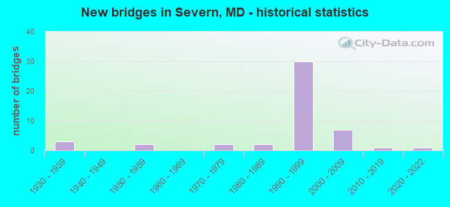
- New bridges - historical statistics
- 31930-1939
- 21950-1959
- 21970-1979
- 21980-1989
- 301990-1999
- 72000-2009
- 12010-2019
- 12020-2022


- Bridge Condition - Deck
- 82.6%Good
- 8.7%Satisfactory
- 8.7%Fair

- Bridge Condition - Superstructure
- 79.2%Good
- 12.5%Satisfactory
- 8.3%Fair

- Bridge Condition - Substructure
- 70.8%Good
- 20.8%Satisfactory
- 8.3%Fair

- Bridge Condition - Channel
- 37.5%Very good
- 37.5%Good
- 18.8%Satisfactory
- 6.3%Fair

- Bridge Condition - Culverts
- 9.1%Very good
- 36.4%Good
- 45.5%Satisfactory
- 9.1%Fair
Find on map >> Show street view
Structure Number: 10000002002301, Location: 1.15 MI N OF MD 713 (Lat: 39.140006, Lng: -76.755347), Route carried "on" structure: State highway 175, Year Built: 1952, Year Reconstructed: 1985, Status: Open, Structure Length: 6.58m (21.59ft), Average Daily Traffic: 19,272 (year 2009), Truck Traffic: 8%, Average Future Daily Traffic: 21,748 (year 2026), Design Load: HS 20, Features Intersected: MD 295
Minimum Vertical Clearance: 30+ m (98+ ft), Kilometerpoint: 13.548, Lanes on structure: 4, Lanes under structure: 6, Owner: State Highway Agency, Approaching Roadway Width: 17.7m (58.1ft), Skew: 1 degrees, Material/Design: Steel, Design/Construction: Stringer/Multi-beam, Number Of Spans In Main Unit: 3, Length of Maximum Span: 21.6m (70.9ft), Curb-To-Curb Width: 17.6m (57.7ft), Out-to-Out Width: 18.3m (60.0ft)
Condition: Deck: Satisfactory, Superstructure: Satisfactory, Substructure: Satisfactory, Operating Rating: 80.3 metric tons, Method Used To Determine Operating Rating: Load Factor (LF), Inventory Rating: 48.1 metric tons, Method Used To Determine Inventory Rating: Load Factor (LF), Structural Evaluation: Equal to present minimum criteria, Deck Geometry: Somewhat better than minimum adequacy, Underclear: Somewhat better than minimum adequacy, Approach Roadway Alignment: Equal to present desirable criteria, Designated Inspection Frequency: Every 24 months, Inspection Date: May 2020, Deck Structure Type: Concrete Cast-file-Place, Wearing Surface/Protective System: Wearing Surface: Bituminous
Find on map >> Show street view
Structure Number: 10000002004401, Location: 1.2 MILE NORTH OF MD 175 (Lat: 39.103969, Lng: -76.693536), Route carried "on" structure: State highway 170, Year Built: 1936, Status: Open, Structure Length: 1.04m (3.41ft), Average Daily Traffic: 21,621 (year 2009), Truck Traffic: 8%, Average Future Daily Traffic: 28,054 (year 2026), Design Load: H 20, Features Intersected: SEVERN RUN
Minimum Vertical Clearance: 30+ m (98+ ft), Kilometerpoint: 1.936, Lanes on structure: 2, Base Highway Network: Yes, Owner: State Highway Agency, Approaching Roadway Width: 11.0m (36.1ft), Skew: 1 degrees, Material/Design: Concrete, Design/Construction: Tee Beam, Number Of Spans In Main Unit: 1, Length of Maximum Span: 9.4m (30.8ft), Curb-To-Curb Width: 12.2m (40.0ft), Out-to-Out Width: 13.4m (44.0ft)
Condition: Deck: Fair, Superstructure: Fair, Substructure: Fair, Channel: Good, Operating Rating: 82.5 metric tons, Method Used To Determine Operating Rating: Load Factor (LF), Inventory Rating: 50.3 metric tons, Method Used To Determine Inventory Rating: Load Factor (LF), Structural Evaluation: Somewhat better than minimum adequacy, Deck Geometry: Somewhat better than minimum adequacy, Waterway Adequacy: Superior to present desirable criteria, Approach Roadway Alignment: Equal to present desirable criteria, Designated Inspection Frequency: Every 24 months, Inspection Date: July 2021, Deck Structure Type: Concrete Cast-file-Place, Wearing Surface/Protective System: Wearing Surface: Monolithic Concrete
Find on map >> Show street view
Structure Number: 10000002005101, Location: 0.08 M W OF BR NO 0216700 (Lat: 39.158453, Lng: -76.697208), Route carried "on" structure: State highway 176, Year Built: 1936, Year Reconstructed: 1989, Status: Open, Structure Length: 2.26m (7.41ft), Average Daily Traffic: 13,400 (year 2013), Truck Traffic: 8%, Average Future Daily Traffic: 17,512 (year 2033), Design Load: HS 20, Features Intersected: AMTRAK
Minimum Vertical Clearance: 30+ m (98+ ft), Kilometerpoint: 3.105, Lanes on structure: 4, Owner: State Highway Agency, Approaching Roadway Width: 17.1m (56.1ft), Material/Design: Steel, Design/Construction: Stringer/Multi-beam, Number Of Spans In Main Unit: 1, Length of Maximum Span: 20.7m (67.9ft), Curb-To-Curb Width: 17.1m (56.1ft), Out-to-Out Width: 18.0m (59.1ft)
Condition: Deck: Good, Superstructure: Satisfactory, Substructure: Satisfactory, Inventory Rating: 74.8 metric tons, Method Used To Determine Inventory Rating: Load Factor (LF), Structural Evaluation: Equal to present minimum criteria, Deck Geometry: Somewhat better than minimum adequacy, Underclear: Meets minimum limits, Approach Roadway Alignment: Equal to present desirable criteria, Length Of Structure Improvement: 2.26m (7.41ft), Designated Inspection Frequency: Every 24 months, Inspection Date: November 2021, Bridge Improvement Cost: $263,000, Roadway Improvement Cost: $26,000, Total Project Cost: $289,000, Deck Structure Type: Concrete Cast-file-Place, Wearing Surface/Protective System: Wearing Surface: Monolithic Concrete
Find on map >> Show street view
Structure Number: 10000002007501, Location: 0.71 MILE SOUTH OF MD 170 (Lat: 39.134483, Lng: -76.697311), Route carried "on" structure: State highway 174, Year Built: 1931, Status: Open, Structure Length: 2.41m (7.91ft), Average Daily Traffic: 18,270 (year 2017), Truck Traffic: 2%, Average Future Daily Traffic: 22,597 (year 2037), Design Load: H 20, Features Intersected: AMTRAK
Minimum Vertical Clearance: 30+ m (98+ ft), Kilometerpoint: 2.848, Lanes on structure: 2, Base Highway Network: Yes, Owner: State Highway Agency, Approaching Roadway Width: 12.2m (40.0ft), Material/Design: Steel, Design/Construction: Girder and Floorbeam System, Number Of Spans In Main Unit: 1, Length of Maximum Span: 22.9m (75.1ft), Curb-To-Curb Width: 8.2m (26.9ft), Out-to-Out Width: 9.4m (30.8ft)
Condition: Deck: Fair, Superstructure: Fair, Substructure: Fair, Operating Rating: 82.1 metric tons, Method Used To Determine Operating Rating: Load Factor (LF), Inventory Rating: 49.4 metric tons, Method Used To Determine Inventory Rating: Load Factor (LF), Structural Evaluation: Somewhat better than minimum adequacy, Deck Geometry: High priority of replacement, Underclear: Somewhat better than minimum adequacy, Approach Roadway Alignment: Equal to present desirable criteria, Length Of Structure Improvement: 2.41m (7.91ft), Designated Inspection Frequency: Every 24 months, Critical Feature Inspection Frequency: Every 24 months, Inspection Date: November 2021, Critical Feature Inspection Date: November 2021, Bridge Improvement Cost: $147,000, Roadway Improvement Cost: $15,000, Total Project Cost: $162,000, Deck Structure Type: Concrete Cast-file-Place, Wearing Surface/Protective System: Wearing Surface: Bituminous
Find on map >> Show street view
Structure Number: 100000020180011, Location: 2.7 MI SE OF IS 95 (Lat: 39.170058, Lng: -76.730817), Route carried "on" structure: State highway 295, Year Built: 1992, Status: Open, Structure Length: 6.34m (20.80ft), Average Daily Traffic: 88,882 (year 0009), Truck Traffic: 8%, Average Future Daily Traffic: 49,228 (year 0026), Design Load: HS 20, Features Intersected: MD 100
Minimum Vertical Clearance: 30+ m (98+ ft), Kilometerpoint: 14.367, Lanes on structure: 3, Lanes under structure: 6, Base Highway Network: Yes, Owner: State Highway Agency, Approaching Roadway Width: 13.4m (44.0ft), Material/Design: Steel continuous, Design/Construction: Stringer/Multi-beam, Number Of Spans In Main Unit: 2, Length of Maximum Span: 31.4m (103.0ft), Curb-To-Curb Width: 13.4m (44.0ft), Out-to-Out Width: 14.6m (47.9ft)
Condition: Deck: Good, Superstructure: Good, Substructure: Good, Operating Rating: 69.4 metric tons, Method Used To Determine Operating Rating: Load Factor (LF), Inventory Rating: 41.7 metric tons, Method Used To Determine Inventory Rating: Load Factor (LF), Structural Evaluation: Better than present minimum criteria, Deck Geometry: Meets minimum limits, Underclear: Equal to present minimum criteria, Approach Roadway Alignment: Equal to present desirable criteria, Length Of Structure Improvement: 6.34m (20.80ft), Designated Inspection Frequency: Every 24 months, Inspection Date: July 2020, Bridge Improvement Cost: $599,000, Roadway Improvement Cost: $60,000, Total Project Cost: $659,000, Deck Structure Type: Concrete Cast-file-Place, Wearing Surface/Protective System: Wearing Surface: Monolithic Concrete, Deck Protection: Epoxy Coated Reinforcing
Find on map >> Show street view
Structure Number: 100000020180012, Location: 2.7 MI SE OF IS 95 (Lat: 39.170747, Lng: -76.730847), Route carried "on" structure: State highway 295, Year Built: 1992, Status: Open, Structure Length: 6.34m (20.80ft), Average Daily Traffic: 88,882 (year 0009), Truck Traffic: 8%, Average Future Daily Traffic: 49,228 (year 0026), Design Load: HS 20, Features Intersected: MD 100
Minimum Vertical Clearance: 30+ m (98+ ft), Kilometerpoint: 14.367, Lanes on structure: 3, Lanes under structure: 6, Base Highway Network: Yes, Owner: State Highway Agency, Approaching Roadway Width: 14.6m (47.9ft), Material/Design: Steel continuous, Design/Construction: Stringer/Multi-beam, Number Of Spans In Main Unit: 2, Length of Maximum Span: 31.4m (103.0ft), Curb-To-Curb Width: 14.6m (47.9ft), Out-to-Out Width: 15.9m (52.2ft)
Condition: Deck: Good, Superstructure: Good, Substructure: Good, Operating Rating: 73.9 metric tons, Method Used To Determine Operating Rating: Load Factor (LF), Inventory Rating: 44.4 metric tons, Method Used To Determine Inventory Rating: Load Factor (LF), Structural Evaluation: Better than present minimum criteria, Deck Geometry: Meets minimum limits, Underclear: Equal to present minimum criteria, Approach Roadway Alignment: Equal to present desirable criteria, Designated Inspection Frequency: Every 24 months, Inspection Date: July 2020, Deck Structure Type: Concrete Cast-file-Place, Wearing Surface/Protective System: Wearing Surface: Monolithic Concrete, Deck Protection: Epoxy Coated Reinforcing
Find on map >> Show street view
Structure Number: 10000002018101, Location: 1 MI E OF MD 295 (Lat: 39.168053, Lng: -76.726667), Route carried "on" structure: State highway 100N, Year Built: 1995, Status: Open, Structure Length: 6.16m (20.21ft), Average Daily Traffic: 730 (year 2009), Truck Traffic: 5%, Average Future Daily Traffic: 888 (year 2026), Design Load: HS 25 or greater, Features Intersected: MD 100
Minimum Vertical Clearance: 30+ m (98+ ft), Kilometerpoint: 0.080, Lanes on structure: 2, Lanes under structure: 6, Owner: State Highway Agency, Approaching Roadway Width: 9.1m (29.9ft), Material/Design: Steel continuous, Design/Construction: Stringer/Multi-beam, Number Of Spans In Main Unit: 2, Length of Maximum Span: 33.8m (110.9ft), Curb-To-Curb Width: 9.1m (29.9ft), Out-to-Out Width: 10.4m (34.1ft)
Condition: Deck: Good, Superstructure: Good, Substructure: Good, Operating Rating: 83.4 metric tons, Method Used To Determine Operating Rating: Load Factor (LF), Inventory Rating: 49.9 metric tons, Method Used To Determine Inventory Rating: Load Factor (LF), Structural Evaluation: Better than present minimum criteria, Deck Geometry: Equal to present minimum criteria, Underclear: Meets minimum limits, Approach Roadway Alignment: Equal to present desirable criteria, Designated Inspection Frequency: Every 24 months, Inspection Date: June 2021, Deck Structure Type: Concrete Cast-file-Place, Wearing Surface/Protective System: Wearing Surface: Monolithic Concrete, Deck Protection: Epoxy Coated Reinforcing
Find on map >> Show street view
Structure Number: 100000020183013, Location: 1.04 MILES N OF MD 295 (Lat: 39.158953, Lng: -76.718819), Route carried "on" structure: State highway 100, Year Built: 1995, Status: Open, Structure Length: 5.85m (19.19ft), Average Daily Traffic: 74,302 (year 2009), Truck Traffic: 8%, Average Future Daily Traffic: 43,233 (year 2026), Design Load: HS 20, Features Intersected: MD 713
Minimum Vertical Clearance: 30+ m (98+ ft), Kilometerpoint: 3.062, Lanes on structure: 3, Lanes under structure: 5, Base Highway Network: Yes, Owner: State Highway Agency, Approaching Roadway Width: 13.4m (44.0ft), Skew: 3 degrees, Material/Design: Steel continuous, Design/Construction: Stringer/Multi-beam, Number Of Spans In Main Unit: 2, Length of Maximum Span: 28.7m (94.2ft), Curb-To-Curb Width: 13.4m (44.0ft), Out-to-Out Width: 14.9m (48.9ft)
Condition: Deck: Good, Superstructure: Good, Substructure: Good, Operating Rating: 74.4 metric tons, Method Used To Determine Operating Rating: Load Factor (LF), Inventory Rating: 44.4 metric tons, Method Used To Determine Inventory Rating: Load Factor (LF), Structural Evaluation: Better than present minimum criteria, Deck Geometry: High priority of replacement, Underclear: Better than present minimum criteria, Approach Roadway Alignment: Equal to present desirable criteria, Designated Inspection Frequency: Every 24 months, Inspection Date: September 2020, Deck Structure Type: Concrete Cast-file-Place, Wearing Surface/Protective System: Wearing Surface: Monolithic Concrete, Deck Protection: Epoxy Coated Reinforcing
Find on map >> Show street view
Structure Number: 100000020183014, Location: 1.04 MILES N OF MD 295 (Lat: 39.158819, Lng: -76.718156), Route carried "on" structure: State highway 100, Year Built: 1995, Status: Open, Structure Length: 5.85m (19.19ft), Average Daily Traffic: 74,302 (year 2009), Truck Traffic: 8%, Average Future Daily Traffic: 43,233 (year 2026), Design Load: HS 20, Features Intersected: MD 713
Minimum Vertical Clearance: 30+ m (98+ ft), Kilometerpoint: 3.062, Lanes on structure: 2, Lanes under structure: 5, Base Highway Network: Yes, Owner: State Highway Agency, Approaching Roadway Width: 11.6m (38.1ft), Skew: 3 degrees, Material/Design: Steel continuous, Design/Construction: Stringer/Multi-beam, Number Of Spans In Main Unit: 2, Length of Maximum Span: 28.7m (94.2ft), Curb-To-Curb Width: 11.6m (38.1ft), Out-to-Out Width: 13.1m (43.0ft)
Condition: Deck: Good, Superstructure: Good, Substructure: Good, Operating Rating: 83.9 metric tons, Method Used To Determine Operating Rating: Load Factor (LF), Inventory Rating: 50.3 metric tons, Method Used To Determine Inventory Rating: Load Factor (LF), Structural Evaluation: Better than present minimum criteria, Deck Geometry: Equal to present minimum criteria, Underclear: Better than present minimum criteria, Approach Roadway Alignment: Equal to present desirable criteria, Designated Inspection Frequency: Every 24 months, Inspection Date: September 2020, Deck Structure Type: Concrete Cast-file-Place, Wearing Surface/Protective System: Wearing Surface: Monolithic Concrete, Deck Protection: Epoxy Coated Reinforcing
Find on map >> Show street view
Structure Number: 10000002018501, Location: 0.5 MI E OF MD 713 (Lat: 39.149397, Lng: -76.706892), Route carried "on" structure: State highway 100P, Year Built: 1995, Status: Open, Structure Length: 6.55m (21.49ft), Average Daily Traffic: 6,211 (year 2009), Truck Traffic: 5%, Average Future Daily Traffic: 6,931 (year 2026), Design Load: HS 25 or greater, Features Intersected: MD 100
Minimum Vertical Clearance: 30+ m (98+ ft), Kilometerpoint: 1.770, Lanes on structure: 2, Lanes under structure: 4, Owner: State Highway Agency, Approaching Roadway Width: 9.1m (29.9ft), Material/Design: Steel continuous, Design/Construction: Stringer/Multi-beam, Number Of Spans In Main Unit: 2, Length of Maximum Span: 32.0m (105.0ft), Curb-To-Curb Width: 9.1m (29.9ft), Out-to-Out Width: 10.4m (34.1ft)
Condition: Deck: Good, Superstructure: Good, Substructure: Good, Inventory Rating: 60.3 metric tons, Method Used To Determine Inventory Rating: Load Factor (LF), Structural Evaluation: Better than present minimum criteria, Deck Geometry: Meets minimum limits, Underclear: Better than present minimum criteria, Approach Roadway Alignment: Equal to present desirable criteria, Designated Inspection Frequency: Every 24 months, Inspection Date: May 2021, Deck Structure Type: Concrete Cast-file-Place, Wearing Surface/Protective System: Wearing Surface: Monolithic Concrete, Deck Protection: Epoxy Coated Reinforcing
Find on map >> Show street view
Structure Number: 100000020186013, Location: 0.5 MI W OF MD 170 (Lat: 39.148047, Lng: -76.703947), Route carried "on" structure: State highway 100, Year Built: 1995, Status: Open, Structure Length: 20.88m (68.50ft), Average Daily Traffic: 74,302 (year 2009), Truck Traffic: 8%, Average Future Daily Traffic: 40,840 (year 2026), Design Load: HS 25 or greater, Features Intersected: STONY RUN
Minimum Vertical Clearance: 30+ m (98+ ft), Kilometerpoint: 4.853, Lanes on structure: 2, Base Highway Network: Yes, Owner: State Highway Agency, Approaching Roadway Width: 11.6m (38.1ft), Material/Design: Steel continuous, Design/Construction: Stringer/Multi-beam, Number Of Spans In Main Unit: 5, Length of Maximum Span: 45.7m (149.9ft), Curb-To-Curb Width: 11.6m (38.1ft), Out-to-Out Width: 12.8m (42.0ft)
Condition: Deck: Good, Superstructure: Good, Substructure: Good, Channel: Very good, Operating Rating: 89.8 metric tons, Method Used To Determine Operating Rating: Load Factor (LF), Inventory Rating: 53.5 metric tons, Method Used To Determine Inventory Rating: Load Factor (LF), Structural Evaluation: Better than present minimum criteria, Deck Geometry: Equal to present minimum criteria, Waterway Adequacy: Superior to present desirable criteria, Approach Roadway Alignment: Equal to present desirable criteria, Designated Inspection Frequency: Every 24 months, Inspection Date: May 2021, Deck Structure Type: Concrete Cast-file-Place, Wearing Surface/Protective System: Wearing Surface: Monolithic Concrete, Deck Protection: Epoxy Coated Reinforcing
Find on map >> Show street view
Structure Number: 100000020186014, Location: 0.5 MI W OF MD 170 (Lat: 39.147881, Lng: -76.701569), Route carried "on" structure: State highway 100, Year Built: 1995, Status: Open, Structure Length: 20.88m (68.50ft), Average Daily Traffic: 74,302 (year 2009), Truck Traffic: 8%, Average Future Daily Traffic: 40,840 (year 2026), Design Load: HS 25 or greater, Features Intersected: STONY RUN
Minimum Vertical Clearance: 30+ m (98+ ft), Kilometerpoint: 4.853, Lanes on structure: 2, Base Highway Network: Yes, Owner: State Highway Agency, Approaching Roadway Width: 11.6m (38.1ft), Material/Design: Steel continuous, Design/Construction: Stringer/Multi-beam, Number Of Spans In Main Unit: 5, Length of Maximum Span: 45.7m (149.9ft), Curb-To-Curb Width: 11.6m (38.1ft), Out-to-Out Width: 12.8m (42.0ft)
Condition: Deck: Good, Superstructure: Good, Substructure: Good, Channel: Very good, Operating Rating: 88.0 metric tons, Method Used To Determine Operating Rating: Load Factor (LF), Inventory Rating: 52.6 metric tons, Method Used To Determine Inventory Rating: Load Factor (LF), Structural Evaluation: Better than present minimum criteria, Deck Geometry: Equal to present minimum criteria, Waterway Adequacy: Superior to present desirable criteria, Approach Roadway Alignment: Equal to present desirable criteria, Designated Inspection Frequency: Every 24 months, Inspection Date: May 2021, Deck Structure Type: Concrete Cast-file-Place, Wearing Surface/Protective System: Wearing Surface: Monolithic Concrete, Deck Protection: Epoxy Coated Reinforcing
Find on map >> Show street view
Structure Number: 100000020187013, Location: 0.4 MI W OF MD 170 (Lat: 39.147494, Lng: -76.697775), Route carried "on" structure: State highway 100, Year Built: 1995, Status: Open, Structure Length: 9.45m (31.00ft), Average Daily Traffic: 35,421 (year 2006), Truck Traffic: 8%, Average Future Daily Traffic: 40,840 (year 2026), Design Load: HS 25 or greater, Features Intersected: AMTRAK, SERVICE ROAD
Minimum Vertical Clearance: 30+ m (98+ ft), Kilometerpoint: 5.403, Lanes on structure: 2, Lanes under structure: 2, Base Highway Network: Yes, Owner: State Highway Agency, Approaching Roadway Width: 11.6m (38.1ft), Material/Design: Steel continuous, Design/Construction: Stringer/Multi-beam, Number Of Spans In Main Unit: 4, Length of Maximum Span: 29.3m (96.1ft), Curb-To-Curb Width: 11.6m (38.1ft), Out-to-Out Width: 12.8m (42.0ft)
Condition: Deck: Good, Superstructure: Good, Substructure: Good, Operating Rating: 76.2 metric tons, Method Used To Determine Operating Rating: Load Factor (LF), Inventory Rating: 45.4 metric tons, Method Used To Determine Inventory Rating: Load Factor (LF), Structural Evaluation: Better than present minimum criteria, Deck Geometry: Better than present minimum criteria, Underclear: Superior to present desirable criteria, Approach Roadway Alignment: Equal to present desirable criteria, Designated Inspection Frequency: Every 24 months, Inspection Date: May 2021, Deck Structure Type: Concrete Cast-file-Place, Wearing Surface/Protective System: Wearing Surface: Monolithic Concrete, Deck Protection: Epoxy Coated Reinforcing
Find on map >> Show street view
Structure Number: 100000020187014, Location: 0.4 MI W OF MD 170 (Lat: 39.147672, Lng: -76.696708), Route carried "on" structure: State highway 100, Year Built: 1995, Status: Open, Structure Length: 9.45m (31.00ft), Average Daily Traffic: 35,421 (year 2006), Truck Traffic: 8%, Average Future Daily Traffic: 40,840 (year 2026), Design Load: HS 25 or greater, Features Intersected: AMTRAK, SERVICE ROAD
Minimum Vertical Clearance: 30+ m (98+ ft), Kilometerpoint: 5.403, Lanes on structure: 2, Lanes under structure: 2, Base Highway Network: Yes, Owner: State Highway Agency, Approaching Roadway Width: 11.6m (38.1ft), Material/Design: Steel continuous, Design/Construction: Stringer/Multi-beam, Number Of Spans In Main Unit: 4, Length of Maximum Span: 29.3m (96.1ft), Curb-To-Curb Width: 11.6m (38.1ft), Out-to-Out Width: 12.8m (42.0ft)
Condition: Deck: Good, Superstructure: Good, Substructure: Good, Operating Rating: 76.2 metric tons, Method Used To Determine Operating Rating: Load Factor (LF), Inventory Rating: 45.4 metric tons, Method Used To Determine Inventory Rating: Load Factor (LF), Structural Evaluation: Better than present minimum criteria, Deck Geometry: Better than present minimum criteria, Underclear: Superior to present desirable criteria, Approach Roadway Alignment: Equal to present desirable criteria, Designated Inspection Frequency: Every 24 months, Inspection Date: May 2021, Deck Structure Type: Concrete Cast-file-Place, Wearing Surface/Protective System: Wearing Surface: Monolithic Concrete, Deck Protection: Epoxy Coated Reinforcing
Find on map >> Show street view
Structure Number: 100000020189013, Location: 1.09 MILES M OF MD 100P (Lat: 39.148739, Lng: -76.687767), Route carried "on" structure: State highway 100, Year Built: 1995, Status: Open, Structure Length: 6.04m (19.82ft), Average Daily Traffic: 68,782 (year 2009), Truck Traffic: 8%, Average Future Daily Traffic: 40,154 (year 2026), Design Load: HS 25 or greater, Features Intersected: MD 170
Minimum Vertical Clearance: 30+ m (98+ ft), Kilometerpoint: 6.280, Lanes on structure: 2, Lanes under structure: 5, Base Highway Network: Yes, Owner: State Highway Agency, Approaching Roadway Width: 13.4m (44.0ft), Skew: 2 degrees, Material/Design: Steel, Design/Construction: Stringer/Multi-beam, Number Of Spans In Main Unit: 1, Length of Maximum Span: 58.5m (191.9ft), Curb-To-Curb Width: 11.6m (38.1ft), Out-to-Out Width: 12.8m (42.0ft)
Condition: Deck: Good, Superstructure: Good, Substructure: Good, Inventory Rating: 76.2 metric tons, Method Used To Determine Inventory Rating: Load Factor (LF), Structural Evaluation: Better than present minimum criteria, Deck Geometry: Equal to present minimum criteria, Underclear: Meets minimum limits, Approach Roadway Alignment: Equal to present desirable criteria, Designated Inspection Frequency: Every 24 months, Inspection Date: July 2020, Deck Structure Type: Concrete Cast-file-Place, Wearing Surface/Protective System: Wearing Surface: Monolithic Concrete, Deck Protection: Epoxy Coated Reinforcing
Find on map >> Show street view
Structure Number: 100000020189014, Location: 1.09 MILES M OF MD 100P (Lat: 39.149078, Lng: -76.687314), Route carried "on" structure: State highway 100, Year Built: 1995, Status: Open, Structure Length: 6.04m (19.82ft), Average Daily Traffic: 68,782 (year 2009), Truck Traffic: 8%, Average Future Daily Traffic: 40,154 (year 2026), Design Load: HS 25 or greater, Features Intersected: MD 170
Minimum Vertical Clearance: 30+ m (98+ ft), Kilometerpoint: 6.280, Lanes on structure: 2, Lanes under structure: 5, Base Highway Network: Yes, Owner: State Highway Agency, Approaching Roadway Width: 11.6m (38.1ft), Skew: 2 degrees, Material/Design: Steel, Design/Construction: Stringer/Multi-beam, Number Of Spans In Main Unit: 1, Length of Maximum Span: 58.5m (191.9ft), Curb-To-Curb Width: 11.6m (38.1ft), Out-to-Out Width: 12.8m (42.0ft)
Condition: Deck: Good, Superstructure: Good, Substructure: Good, Inventory Rating: 76.2 metric tons, Method Used To Determine Inventory Rating: Load Factor (LF), Structural Evaluation: Better than present minimum criteria, Deck Geometry: Equal to present minimum criteria, Underclear: Meets minimum limits, Approach Roadway Alignment: Equal to present desirable criteria, Designated Inspection Frequency: Every 24 months, Inspection Date: July 2020, Deck Structure Type: Concrete Cast-file-Place, Wearing Surface/Protective System: Wearing Surface: Monolithic Concrete, Deck Protection: Epoxy Coated Reinforcing
Find on map >> Show street view
Structure Number: 10000002019001, Location: 1 MI E OF MD 170 (Lat: 39.153356, Lng: -76.676550), Route carried "on" structure: State highway 100Q, Year Built: 1995, Status: Open, Structure Length: 9.54m (31.30ft), Average Daily Traffic: 1,211 (year 2009), Truck Traffic: 5%, Average Future Daily Traffic: 1,685 (year 2026), Design Load: HS 25 or greater, Features Intersected: MD 100
Minimum Vertical Clearance: 30+ m (98+ ft), Kilometerpoint: 0.644, Lanes on structure: 2, Lanes under structure: 6, Owner: State Highway Agency, Approaching Roadway Width: 9.1m (29.9ft), Skew: 4 degrees, Material/Design: Steel continuous, Design/Construction: Stringer/Multi-beam, Number Of Spans In Main Unit: 2, Length of Maximum Span: 47.2m (154.9ft), Curb-To-Curb Width: 9.1m (29.9ft), Out-to-Out Width: 10.4m (34.1ft)
Condition: Deck: Good, Superstructure: Good, Substructure: Good, Inventory Rating: 65.8 metric tons, Method Used To Determine Inventory Rating: Load Factor (LF), Structural Evaluation: Better than present minimum criteria, Deck Geometry: Somewhat better than minimum adequacy, Underclear: Somewhat better than minimum adequacy, Approach Roadway Alignment: Equal to present desirable criteria, Designated Inspection Frequency: Every 24 months, Inspection Date: October 2020, Deck Structure Type: Concrete Cast-file-Place, Wearing Surface/Protective System: Wearing Surface: Monolithic Concrete, Deck Protection: Epoxy Coated Reinforcing
Find on map >> Show street view
Structure Number: 100000020206013, Location: 0.41 MILE WEST OF MD 170 (Lat: 39.101472, Lng: -76.701806), Route carried "on" structure: State highway 32, Year Built: 1991, Status: Open, Structure Length: 7.92m (25.98ft), Average Daily Traffic: 53,532 (year 2018), Truck Traffic: 6%, Average Future Daily Traffic: 98,000 (year 2038), Design Load: HS 20, Features Intersected: AMTRAK
Minimum Vertical Clearance: 30+ m (98+ ft), Kilometerpoint: 7.928, Lanes on structure: 3, Base Highway Network: Yes, Owner: State Highway Agency, Approaching Roadway Width: 15.2m (49.9ft), Skew: 1 degrees, Material/Design: Steel continuous, Design/Construction: Stringer/Multi-beam, Number Of Spans In Main Unit: 3, Length of Maximum Span: 32.0m (105.0ft), Curb-To-Curb Width: 15.2m (49.9ft), Out-to-Out Width: 16.5m (54.1ft)
Condition: Deck: Good, Superstructure: Good, Substructure: Satisfactory, Structural Evaluation: Equal to present minimum criteria, Deck Geometry: Meets minimum limits, Underclear: Superior to present desirable criteria, Approach Roadway Alignment: Equal to present desirable criteria, Designated Inspection Frequency: Every 24 months, Inspection Date: April 2021, Deck Structure Type: Concrete Cast-file-Place, Wearing Surface/Protective System: Wearing Surface: Monolithic Concrete, Deck Protection: Epoxy Coated Reinforcing
Find on map >> Show street view
Structure Number: 100000020206014, Location: 0.41 MILE WEST OF MD 170 (Lat: 39.101750, Lng: -76.701750), Route carried "on" structure: State highway 32, Year Built: 1991, Status: Open, Structure Length: 7.92m (25.98ft), Average Daily Traffic: 53,532 (year 2018), Truck Traffic: 6%, Average Future Daily Traffic: 98,000 (year 2038), Design Load: HS 20, Features Intersected: AMTRAK
Minimum Vertical Clearance: 30+ m (98+ ft), Kilometerpoint: 7.928, Lanes on structure: 3, Base Highway Network: Yes, Owner: State Highway Agency, Approaching Roadway Width: 16.2m (53.1ft), Skew: 1 degrees, Material/Design: Steel continuous, Design/Construction: Stringer/Multi-beam, Number Of Spans In Main Unit: 3, Length of Maximum Span: 32.0m (105.0ft), Curb-To-Curb Width: 16.2m (53.1ft), Out-to-Out Width: 17.4m (57.1ft)
Condition: Deck: Good, Superstructure: Good, Substructure: Good, Structural Evaluation: Better than present minimum criteria, Deck Geometry: Equal to present minimum criteria, Underclear: Superior to present desirable criteria, Approach Roadway Alignment: Equal to present desirable criteria, Designated Inspection Frequency: Every 24 months, Inspection Date: April 2021, Deck Structure Type: Concrete Cast-file-Place, Wearing Surface/Protective System: Wearing Surface: Monolithic Concrete, Deck Protection: Epoxy Coated Reinforcing
Find on map >> Show street view
Structure Number: 100000020207013, Location: 0.79 MILE EAST OF MD 175 (Lat: 39.100092, Lng: -76.707369), Route carried "on" structure: State highway 32, Year Built: 1992, Status: Open, Structure Length: 2.32m (7.61ft), Average Daily Traffic: 43,672 (year 2009), Truck Traffic: 8%, Average Future Daily Traffic: 23,545 (year 2026), Design Load: HS 20, Features Intersected: TOWN CENTER BOLEVARD
Minimum Vertical Clearance: 30+ m (98+ ft), Kilometerpoint: 8.496, Lanes on structure: 2, Lanes under structure: 4, Base Highway Network: Yes, Owner: State Highway Agency, Approaching Roadway Width: 11.6m (38.1ft), Skew: 2 degrees, Material/Design: Steel, Design/Construction: Stringer/Multi-beam, Number Of Spans In Main Unit: 1, Length of Maximum Span: 23.2m (76.1ft), Curb-To-Curb Width: 11.6m (38.1ft), Out-to-Out Width: 13.0m (42.7ft)
Condition: Deck: Good, Superstructure: Satisfactory, Substructure: Satisfactory, Structural Evaluation: Equal to present minimum criteria, Deck Geometry: Equal to present minimum criteria, Underclear: High priority of corrective action, Approach Roadway Alignment: Equal to present desirable criteria, Designated Inspection Frequency: Every 24 months, Inspection Date: March 2020, Deck Structure Type: Concrete Cast-file-Place, Wearing Surface/Protective System: Wearing Surface: Monolithic Concrete, Deck Protection: Epoxy Coated Reinforcing
Find on map >> Show street view
Structure Number: 100000020207014, Location: 0.79 MILE EAST OF MD 175 (Lat: 39.100428, Lng: -76.707178), Route carried "on" structure: State highway 32, Year Built: 1992, Status: Open, Structure Length: 2.32m (7.61ft), Average Daily Traffic: 43,672 (year 2009), Truck Traffic: 8%, Average Future Daily Traffic: 23,545 (year 2026), Design Load: HS 20, Features Intersected: TOWN CENTER BOLEVARD
Minimum Vertical Clearance: 30+ m (98+ ft), Kilometerpoint: 8.496, Lanes on structure: 2, Lanes under structure: 4, Base Highway Network: Yes, Owner: State Highway Agency, Approaching Roadway Width: 12.5m (41.0ft), Skew: 2 degrees, Material/Design: Steel, Design/Construction: Stringer/Multi-beam, Number Of Spans In Main Unit: 1, Length of Maximum Span: 23.2m (76.1ft), Curb-To-Curb Width: 12.5m (41.0ft), Out-to-Out Width: 14.0m (45.9ft)
Condition: Deck: Good, Superstructure: Good, Substructure: Satisfactory, Structural Evaluation: Equal to present minimum criteria, Deck Geometry: Better than present minimum criteria, Underclear: Meets minimum limits, Approach Roadway Alignment: Equal to present desirable criteria, Designated Inspection Frequency: Every 24 months, Inspection Date: March 2020, Deck Structure Type: Concrete Cast-file-Place, Wearing Surface/Protective System: Wearing Surface: Monolithic Concrete, Deck Protection: Epoxy Coated Reinforcing
Find on map >> Show street view
Structure Number: 10000002022903, Location: WEST OF 195 (Lat: 39.177056, Lng: -76.701375), Route carried "on" structure: State highway 758, Year Built: 2005, Status: Open, Structure Length: 1.22m (4.00ft), Average Daily Traffic: 700 (year 2014), Average Future Daily Traffic: 1,000 (year 2036), Design Load: HS 25 or greater, Features Intersected: TRIB TO STONY RUN
Minimum Vertical Clearance: 30+ m (98+ ft), Kilometerpoint: 1.403, Lanes on structure: 3, Base Highway Network: Yes, Owner: State Highway Agency, Approaching Roadway Width: 14.3m (46.9ft), Material/Design: Steel, Design/Construction: Culvert, Number Of Spans In Main Unit: 1, Length of Maximum Span: 12.2m (40.0ft)
Condition: Channel: Very good, Culverts: Satisfactory, Operating Rating: 40.8 metric tons, Method Used To Determine Operating Rating: Field evaluation and documented engineering judgment, Inventory Rating: 40.8 metric tons, Method Used To Determine Inventory Rating: Allowable Stress (AS), Structural Evaluation: Equal to present minimum criteria, Waterway Adequacy: Equal to present desirable criteria, Approach Roadway Alignment: Equal to present desirable criteria, Designated Inspection Frequency: Every 24 months, Inspection Date: April 2020, Wearing Surface/Protective System: Wearing Surface: Bituminous
Find on map >> Show street view
Structure Number: 200000AA201003, Location: 0.9 MI. E. OF MD 295 (Lat: 39.151997, Lng: -76.732986), Route carried "on" structure: County highway , Year Built: 2001, Status: Open, Structure Length: 0.76m (2.49ft), Average Daily Traffic: 25,012 (year 2018), Truck Traffic: 2%, Average Future Daily Traffic: 26,000 (year 2040), Design Load: HS 25 or greater, Features Intersected: PINEY RUN, Facility Carried by Structure: ARUNDEL MILLS BOUL
Minimum Vertical Clearance: 30+ m (98+ ft), Kilometerpoint: 1.078, Lanes on structure: 5, Owner: County Highway Agency, Approaching Roadway Width: 18.3m (60.0ft), Skew: 30 degrees, Material/Design: Steel, Design/Construction: Culvert, Length of Maximum Span: 3.0m (9.8ft), Curb or Sidewalk Widths: Left: 0.2m (0.7ft), Right: 0.2m (0.7ft)
Condition: Channel: Good, Culverts: Satisfactory, Structural Evaluation: Equal to present minimum criteria, Waterway Adequacy: Equal to present desirable criteria, Approach Roadway Alignment: Equal to present desirable criteria, Designated Inspection Frequency: Every 24 months, Inspection Date: July 2021
Find on map >> Show street view
Structure Number: 200000AA201203, Location: 0.4 MI EAST OF HARMANS RD (Lat: 39.144364, Lng: -76.704258), Route carried "on" structure: County highway , Year Built: 1984, Status: Open, Structure Length: 1.16m (3.81ft), Average Daily Traffic: 2,651 (year 2018), Average Future Daily Traffic: 2,700 (year 2040), Design Load: HS 20, Features Intersected: STONEY RUN, Facility Carried by Structure: GESNA DRIVE
Minimum Vertical Clearance: 30+ m (98+ ft), Kilometerpoint: 0.600, Lanes on structure: 2, Owner: County Highway Agency, Approaching Roadway Width: 11.0m (36.1ft), Material/Design: Steel, Design/Construction: Culvert, Length of Maximum Span: 1.5m (4.9ft), Curb or Sidewalk Widths: Left: 0.2m (0.7ft), Right: 0.2m (0.7ft)
Condition: Channel: Satisfactory, Culverts: Satisfactory, Structural Evaluation: Equal to present minimum criteria, Waterway Adequacy: Somewhat better than minimum adequacy, Approach Roadway Alignment: Equal to present desirable criteria, Designated Inspection Frequency: Every 24 months, Inspection Date: August 2021
Find on map >> Show street view
Structure Number: 200000AA201503, Location: 0.35 MI N of MD 100 (Lat: 39.153908, Lng: -76.703347), Route carried "on" structure: County highway , Year Built: 1991, Status: Open, Structure Length: 0.95m (3.12ft), Average Daily Traffic: 7,417 (year 2016), Average Future Daily Traffic: 9,418 (year 2040), Features Intersected: TRIBUTARY TO STONY RUN, Facility Carried by Structure: HARMANS ROAD
Minimum Vertical Clearance: 30+ m (98+ ft), Kilometerpoint: 0.563, Lanes on structure: 2, Owner: County Highway Agency, Approaching Roadway Width: 11.0m (36.1ft), Material/Design: Concrete, Design/Construction: Culvert, Length of Maximum Span: 0.6m (2.0ft), Curb or Sidewalk Widths: Left: 1.1m (3.6ft), Right: 1.2m (3.9ft)
Condition: Channel: Very good, Culverts: Good, Operating Rating: 32.7 metric tons, Method Used To Determine Operating Rating: Field evaluation and documented engineering judgment, Inventory Rating: 32.7 metric tons, Method Used To Determine Inventory Rating: Field evaluation and documented engineering judgment, Structural Evaluation: Better than present minimum criteria, Waterway Adequacy: Equal to present desirable criteria, Approach Roadway Alignment: Equal to present desirable criteria, Designated Inspection Frequency: Every 12 months, Inspection Date: March 2021
Find on map >> Show street view
Structure Number: 200000AA301302, Location: 1.58 MI S of MD174 (Lat: 39.118997, Lng: -76.673194), Route carried "on" structure: County highway , Year Built: 2001, Status: Open, Structure Length: 0.66m (2.17ft), Average Daily Traffic: 3,950 (year 2016), Truck Traffic: 1%, Average Future Daily Traffic: 8,894 (year 2040), Features Intersected: UNNAMED TRIBUTARY TO SEV, Facility Carried by Structure: QUARTERFIELD ROAD
Minimum Vertical Clearance: 30+ m (98+ ft), Kilometerpoint: 2.542, Lanes on structure: 2, Owner: County Highway Agency, Approaching Roadway Width: 12.5m (41.0ft), Skew: 3 degrees, Material/Design: Aluminum, Iron, Design/Construction: Culvert, Length of Maximum Span: 6.4m (21.0ft), Curb or Sidewalk Widths: Left: 1.2m (3.9ft), Right: 1.2m (3.9ft)
Condition: Channel: Good, Culverts: Good, Operating Rating: 32.7 metric tons, Method Used To Determine Operating Rating: Field evaluation and documented engineering judgment, Inventory Rating: 32.7 metric tons, Method Used To Determine Inventory Rating: Field evaluation and documented engineering judgment, Structural Evaluation: Better than present minimum criteria, Waterway Adequacy: Equal to present desirable criteria, Approach Roadway Alignment: Equal to present desirable criteria, Designated Inspection Frequency: Every 24 months, Inspection Date: March 2020
Find on map >> Show street view
Structure Number: 200000AA400801, Location: 2.4 MILES NORTH OF MD 32 (Lat: 39.108447, Lng: -76.651472), Route carried "on" structure: County highway 1332, Year Built: 2001, Status: Open, Structure Length: 1.92m (6.30ft), Average Daily Traffic: 10,126 (year 2018), Truck Traffic: 5%, Average Future Daily Traffic: 13,200 (year 2040), Design Load: HS 25 or greater, Features Intersected: SEVERN RUN, Facility Carried by Structure: NEW CUT ROAD
Minimum Vertical Clearance: 30+ m (98+ ft), Kilometerpoint: 4.023, Lanes on structure: 2, Base Highway Network: Yes, Owner: County Highway Agency, Approaching Roadway Width: 14.6m (47.9ft), Skew: 1 degrees, Material/Design: Steel, Design/Construction: Stringer/Multi-beam, Number Of Spans In Main Unit: 1, Length of Maximum Span: 18.0m (59.1ft), Curb-To-Curb Width: 14.6m (47.9ft), Out-to-Out Width: 15.6m (51.2ft)
Condition: Deck: Good, Superstructure: Good, Substructure: Good, Channel: Good, Inventory Rating: 76.2 metric tons, Method Used To Determine Inventory Rating: Load Factor (LF), Structural Evaluation: Better than present minimum criteria, Deck Geometry: Superior to present desirable criteria, Waterway Adequacy: Equal to present desirable criteria, Approach Roadway Alignment: Equal to present minimum criteria, Length Of Structure Improvement: 30.45m (99.90ft), Designated Inspection Frequency: Every 24 months, Inspection Date: March 2020, Bridge Improvement Cost: $999,000, Roadway Improvement Cost: $999,000, Total Project Cost: $9,999,000, Deck Structure Type: Concrete Cast-file-Place, Wearing Surface/Protective System: Wearing Surface: Monolithic Concrete, Deck Protection: Epoxy Coated Reinforcing
Find on map >> Show street view
Structure Number: 200000AA401202, Location: 1.06 MI N OF MD 175 (Lat: 39.129892, Lng: -76.717636), Route carried "on" structure: County highway 936, Year Built: 1974, Status: Open, Structure Length: 0.64m (2.10ft), Average Daily Traffic: 5,842 (year 2016), Truck Traffic: 5%, Average Future Daily Traffic: 8,853 (year 2038), Design Load: HS 20, Features Intersected: SEVERN RUN, Facility Carried by Structure: DISNEY ROAD
Minimum Vertical Clearance: 30+ m (98+ ft), Kilometerpoint: 1.706, Lanes on structure: 3, Owner: County Highway Agency, Approaching Roadway Width: 12.2m (40.0ft), Material/Design: Concrete, Design/Construction: Culvert, Length of Maximum Span: 3.0m (9.8ft), Curb or Sidewalk Widths: Left: 1.2m (3.9ft), Right: 1.2m (3.9ft)
Condition: Channel: Satisfactory, Culverts: Satisfactory, Inventory Rating: 72.1 metric tons, Method Used To Determine Inventory Rating: Load Factor (LF), Structural Evaluation: Equal to present minimum criteria, Waterway Adequacy: Better than present minimum criteria, Approach Roadway Alignment: Equal to present minimum criteria, Length Of Structure Improvement: 304.77m (999.90ft), Designated Inspection Frequency: Every 24 months, Inspection Date: March 2020, Bridge Improvement Cost: $999,000, Roadway Improvement Cost: $999,000, Total Project Cost: $6,100,000 ( Estimate for 2020)
Find on map >> Show street view
Structure Number: 200000AA401302, Location: 0.64 MI E OF MD 174 (Lat: 39.113781, Lng: -76.706411), Route carried "on" structure: County highway 1013, Year Built: 1974, Status: Posted for load, Structure Length: 1.40m (4.59ft), Average Daily Traffic: 4,339 (year 2018), Truck Traffic: 5%, Average Future Daily Traffic: 4,800 (year 2040), Design Load: H 20, Features Intersected: SEVERN RUN, Facility Carried by Structure: JACOBS ROAD
Minimum Vertical Clearance: 30+ m (98+ ft), Kilometerpoint: 1.030, Lanes on structure: 2, Owner: County Highway Agency, Approaching Roadway Width: 12.2m (40.0ft), Material/Design: Concrete, Design/Construction: Culvert, Number Of Spans In Main Unit: 3, Length of Maximum Span: 4.3m (14.1ft), Curb or Sidewalk Widths: Left: 1.2m (3.9ft), Right: 0.0m
Condition: Channel: Satisfactory, Culverts: Satisfactory, Operating Rating: 24.5 metric tons, Method Used To Determine Operating Rating: Load Factor (LF), Inventory Rating: 14.5 metric tons, Method Used To Determine Inventory Rating: Load Factor (LF), Structural Evaluation: Meets minimum limits, Waterway Adequacy: Equal to present desirable criteria, Approach Roadway Alignment: Equal to present desirable criteria, Bridge Posting: Required (Relationship of Operating Rating to Maximum Legal Load: > 39.9% below), Length Of Structure Improvement: 2.65m (8.69ft), Designated Inspection Frequency: Every 12 months, Inspection Date: March 2021, Bridge Improvement Cost: $10,000, Roadway Improvement Cost: $21,000, Total Project Cost: $31,000 ( Estimate for 2017)
Find on map >> Show street view
Structure Number: 200000AA401703, Location: 0.5 MI. W. OF RIDGE RD. (Lat: 39.166753, Lng: -76.723567), Route carried "on" structure: County highway 938, Year Built: 2007, Status: Open, Structure Length: 1.43m (4.69ft), Average Daily Traffic: 1,531 (year 2016), Truck Traffic: 5%, Average Future Daily Traffic: 2,377 (year 2037), Features Intersected: TRIBUTARY TO PINEY RUN, Facility Carried by Structure: CLARK ROAD
Minimum Vertical Clearance: 30+ m (98+ ft), Kilometerpoint: 0.000, Lanes on structure: 2, Owner: County Highway Agency, Approaching Roadway Width: 7.3m (24.0ft), Skew: 3 degrees, Material/Design: Concrete, Design/Construction: Culvert, Length of Maximum Span: 3.0m (9.8ft)
Condition: Channel: Good, Culverts: Good, Inventory Rating: 57.1 metric tons, Method Used To Determine Inventory Rating: Load Factor (LF), Structural Evaluation: Better than present minimum criteria, Waterway Adequacy: Better than present minimum criteria, Approach Roadway Alignment: Equal to present desirable criteria, Designated Inspection Frequency: Every 24 months, Inspection Date: November 2021
Find on map >> Show street view
Structure Number: 200000AA402003, Location: 0.5 MI. N OF MD32 (Lat: 39.106556, Lng: -76.710000), Route carried "on" structure: County highway 6253, Year Built: 1988, Status: Open, Structure Length: 0.82m (2.69ft), Average Daily Traffic: 5,468 (year 2016), Truck Traffic: 5%, Average Future Daily Traffic: 6,672 (year 2038), Design Load: H 20, Features Intersected: TRIBUTARY TO SEVERN RUN, Facility Carried by Structure: TOWN CENTER BLVD.
Minimum Vertical Clearance: 30+ m (98+ ft), Kilometerpoint: 0.000, Lanes on structure: 4, Owner: County Highway Agency, Approaching Roadway Width: 21.9m (71.9ft), Skew: 1 degrees, Material/Design: Steel, Design/Construction: Culvert, Length of Maximum Span: 3.0m (9.8ft)
Condition: Channel: Fair, Culverts: Fair, Structural Evaluation: Somewhat better than minimum adequacy, Waterway Adequacy: Better than present minimum criteria, Approach Roadway Alignment: Equal to present desirable criteria, Length Of Structure Improvement: 4.18m (13.71ft), Designated Inspection Frequency: Every 24 months, Inspection Date: August 2020, Bridge Improvement Cost: $57,000, Roadway Improvement Cost: $10,000, Total Project Cost: $67,000
Find on map >> Show street view
Structure Number: 200000AA402202, Location: 0.36 MI. E. OF SEVERN RD (Lat: 39.140275, Lng: -76.712403), Route carried "on" structure: County highway , Year Built: 2016, Status: Open, Structure Length: 0.66m (2.17ft), Average Daily Traffic: 5,795 (year 2016), Truck Traffic: 1%, Average Future Daily Traffic: 7,213 (year 2038), Features Intersected: STONY RUN, Facility Carried by Structure: HARMANS ROAD
Minimum Vertical Clearance: 30+ m (98+ ft), Kilometerpoint: 0.000, Lanes on structure: 2, Owner: County Highway Agency, Approaching Roadway Width: 11.0m (36.1ft), Material/Design: Concrete, Design/Construction: Culvert, Length of Maximum Span: 1.8m (5.9ft), Curb or Sidewalk Widths: Left: 1.8m (5.9ft), Right: 1.8m (5.9ft)
Condition: Channel: Very good, Culverts: Good, Operating Rating: 57.7 metric tons, Method Used To Determine Operating Rating: Load and Resistance Factor Rating (LRFR) rating reported by rating factor(RF) method using HL-93 loadings, Inventory Rating: 44.4 metric tons, Method Used To Determine Inventory Rating: Load and Resistance Factor Rating (LRFR) rating reported by rating factor(RF) method using HL-93 loadings, Structural Evaluation: Better than present minimum criteria, Waterway Adequacy: Superior to present desirable criteria, Approach Roadway Alignment: Equal to present desirable criteria, Designated Inspection Frequency: Every 24 months, Inspection Date: June 2020
Find on map >> Show street view
Structure Number: 200000AA402503, Location: 0.5 MI W OF BURNS CR. RD (Lat: 39.089292, Lng: -76.668431), Route carried "on" structure: ServiceOther road , Year Built: 2000, Status: Open, Structure Length: 0.77m (2.53ft), Average Daily Traffic: 869 (year 2018), Average Future Daily Traffic: 869 (year 2040), Features Intersected: TRIB TO SEVERN RIVER, Facility Carried by Structure: MILLERSVILLE LANDF
Minimum Vertical Clearance: 30+ m (98+ ft), Kilometerpoint: 0.000, Lanes on structure: 2, Owner: County Highway Agency, Approaching Roadway Width: 9.8m (32.2ft), Material/Design: Aluminum, Iron, Design/Construction: Arch - Deck, Number Of Spans In Main Unit: 1, Length of Maximum Span: 7.6m (24.9ft), Curb-To-Curb Width: 9.6m (31.5ft), Out-to-Out Width: 12.8m (42.0ft)
Condition: Superstructure: Good, Substructure: Good, Channel: Good, Structural Evaluation: Better than present minimum criteria, Deck Geometry: Equal to present minimum criteria, Waterway Adequacy: Equal to present desirable criteria, Approach Roadway Alignment: Equal to present desirable criteria, Designated Inspection Frequency: Every 24 months, Inspection Date: August 2021
Find on map >> Show street view
Structure Number: 200000AA403502, Location: .7 MI S OF ROUTE 3 (Lat: 40.324211, Lng: -1000.677775), Route carried "on" structure: County highway , Year Built: 2020, Status: Open, Structure Length: 1.72m (5.64ft), Average Daily Traffic: 13,571 (year 2019), Truck Traffic: 5%, Average Future Daily Traffic: 16,557 (year 2039), Features Intersected: UNNAMED TRIBUTARY TO SEV, Facility Carried by Structure: NEW CUT ROAD
Minimum Vertical Clearance: 30+ m (98+ ft), Kilometerpoint: 0.000, Lanes on structure: 2, Owner: County Highway Agency, Approaching Roadway Width: 13.4m (44.0ft), Material/Design: Concrete, Design/Construction: Culvert, Length of Maximum Span: 3.7m (12.1ft)
Condition: Channel: Very good, Culverts: Very good, Operating Rating: 68.0 metric tons, Method Used To Determine Operating Rating: Load and Resistance Factor Rating (LRFR) rating reported by rating factor(RF) method using HL-93 loadings, Inventory Rating: 52.5 metric tons, Method Used To Determine Inventory Rating: Load and Resistance Factor Rating (LRFR) rating reported by rating factor(RF) method using HL-93 loadings, Structural Evaluation: Equal to present desirable criteria, Waterway Adequacy: Equal to present desirable criteria, Approach Roadway Alignment: Equal to present desirable criteria, Designated Inspection Frequency: Every 24 months, Inspection Date: May 2020
Find on map >> Show street view
Structure Number: 300000AAMA2101, Location: CRCF - BWI AIRPORT (Lat: 39.174483, Lng: -76.703925), Route carried "on" structure: Ramp Other road , Year Built: 2003, Status: Open, Structure Length: 2.74m (8.99ft), Average Daily Traffic: 113 (year 2018), Average Future Daily Traffic: 134 (year 2029), Features Intersected: SOUTH END OF CONSOLIDATE, Facility Carried by Structure: SECOND LEVEL ENTRA
Minimum Vertical Clearance: 2.44m (8.01ft), Kilometerpoint: 0.000, Lanes on structure: 2, Lanes under structure: 2, Owner: State Agenciy, Approaching Roadway Width: 8.5m (27.9ft), Material/Design: Prestressed concrete continuous, Design/Construction: Box Beam or Girders - Single/Spread, Number Of Spans In Main Unit: 2, Length of Maximum Span: 14.0m (45.9ft), Curb-To-Curb Width: 8.5m (27.9ft), Out-to-Out Width: 9.8m (32.2ft)
Condition: Deck: Satisfactory, Superstructure: Good, Substructure: Good, Operating Rating: 88.4 metric tons, Method Used To Determine Operating Rating: Load Factor (LF), Inventory Rating: 34.9 metric tons, Method Used To Determine Inventory Rating: Load Factor (LF), Structural Evaluation: Better than present minimum criteria, Deck Geometry: High priority of corrective action, Underclear: Somewhat better than minimum adequacy, Approach Roadway Alignment: Somewhat better than minimum adequacy, Designated Inspection Frequency: Every 24 months, Inspection Date: June 2020, Deck Structure Type: Concrete Cast-file-Place, Wearing Surface/Protective System: Wearing Surface: Monolithic Concrete, Deck Protection: Epoxy Coated Reinforcing
Find on map >> Show street view
Structure Number: 10000002002301, Location: 1079 M S OF MD 176B (Lat: 39.140006, Lng: -76.755347), Route carried "under" structure: State highway 295, Year Built: 1952, Structure Length: 0. m, Average Daily Traffic: 88,600 (year 2009), Features Intersected: MD 295, Facility Carried by Structure: MD 175
Minimum Vertical Clearance: 4.88m (16.01ft), Kilometerpoint: 10.378, Lanes on structure: 4, Lanes under structure: 6, Material/Design: Steel, Design/Construction: Stringer/Multi-beam, Length of Maximum Span: 21.6m (70.9ft)
Find on map >> Show street view
Structure Number: 10000002006201, Location: 0.4 MI S OF MD 176 (Lat: 39.161206, Lng: -76.644964), Route carried "under" structure: Interstate 97, Year Built: 1991, Structure Length: 0. m, Average Daily Traffic: 119,260 (year 2009), Features Intersected: IS 97, Facility Carried by Structure: STEWART AVENUE
Minimum Vertical Clearance: 4.88m (16.01ft), Kilometerpoint: 23.202, Lanes on structure: 4, Lanes under structure: 11, Material/Design: Steel continuous, Design/Construction: Stringer/Multi-beam, Length of Maximum Span: 50.9m (167.0ft)
Find on map >> Show street view
Structure Number: 100000020180011, Location: .88 M E OF HOWARD CO LINE (Lat: 39.170058, Lng: -76.730817), Route carried "under" structure: State highway 100, Year Built: 1992, Structure Length: 0. m, Average Daily Traffic: 78,282 (year 2009), Truck Traffic: 8%, Features Intersected: MD 100, Facility Carried by Structure: MD 295 NBR
Minimum Vertical Clearance: 6.10m (20.01ft), Kilometerpoint: 1.416, Lanes on structure: 3, Lanes under structure: 6, Material/Design: Steel continuous, Design/Construction: Stringer/Multi-beam, Length of Maximum Span: 31.4m (103.0ft)
Find on map >> Show street view
Structure Number: 100000020180012, Location: .88 M E OF HOWARD CO LINE (Lat: 39.170747, Lng: -76.730847), Route carried "under" structure: State highway 100, Year Built: 1992, Structure Length: 0. m, Average Daily Traffic: 78,282 (year 2009), Truck Traffic: 8%, Features Intersected: MD 100, Facility Carried by Structure: MD 295 SBR
Minimum Vertical Clearance: 5.79m (19.00ft), Kilometerpoint: 1.416, Lanes on structure: 3, Lanes under structure: 6, Material/Design: Steel continuous, Design/Construction: Stringer/Multi-beam, Length of Maximum Span: 39.6m (129.9ft)
Find on map >> Show street view
Structure Number: 10000002018101, Location: 0.78 MILE WEST OF MD 713 (Lat: 39.168053, Lng: -76.726667), Route carried "under" structure: State highway 100, Year Built: 1995, Structure Length: 0. m, Average Daily Traffic: 78,282 (year 2009), Truck Traffic: 8%, Features Intersected: MD 100
Minimum Vertical Clearance: 5.18m (16.99ft), Kilometerpoint: 1.834, Lanes on structure: 2, Lanes under structure: 6, Material/Design: Steel continuous, Design/Construction: Stringer/Multi-beam, Length of Maximum Span: 33.8m (110.9ft)
Find on map >> Show street view
Structure Number: 100000020183013, Location: 0.19 MILE SOUTH OF MD 176 (Lat: 39.158953, Lng: -76.718819), Route carried "under" structure: State highway 713, Year Built: 1995, Structure Length: 0. m, Average Daily Traffic: 23,820 (year 2009), Truck Traffic: 8%, Features Intersected: MD 713, Facility Carried by Structure: MD 100 EBR
Minimum Vertical Clearance: 5.18m (16.99ft), Kilometerpoint: 4.602, Lanes on structure: 3, Lanes under structure: 5, Material/Design: Steel continuous, Design/Construction: Stringer/Multi-beam, Length of Maximum Span: 28.7m (94.2ft)
Find on map >> Show street view
Structure Number: 100000020183014, Location: 0.19 MILE SOUTH OF MD 176 (Lat: 39.158819, Lng: -76.718156), Route carried "under" structure: State highway 713, Year Built: 1995, Structure Length: 0. m, Average Daily Traffic: 23,820 (year 2009), Truck Traffic: 8%, Features Intersected: MD 713, Facility Carried by Structure: MD 100 WBR
Minimum Vertical Clearance: 5.18m (16.99ft), Kilometerpoint: 4.602, Lanes on structure: 2, Lanes under structure: 5, Material/Design: Steel continuous, Design/Construction: Stringer/Multi-beam, Length of Maximum Span: 28.7m (94.2ft)
Find on map >> Show street view
Structure Number: 10000002018401, Location: 0.71 MILE SOUTH OF MD 100 (Lat: 39.162025, Lng: -76.738508), Route carried "under" structure: State highway 295, Year Built: 1990, Structure Length: 0. m, Average Daily Traffic: 88,600 (year 2009), Truck Traffic: 8%, Features Intersected: MD 295, Facility Carried by Structure: MD176B (WRIGHT RD)
Minimum Vertical Clearance: 4.88m (16.01ft), Kilometerpoint: 13.258, Lanes on structure: 2, Lanes under structure: 4, Material/Design: Steel continuous, Design/Construction: Stringer/Multi-beam, Length of Maximum Span: 42.1m (138.1ft)
Find on map >> Show street view
Structure Number: 10000002018501, Location: 0.91 MILE WEST OF MD 713 (Lat: 39.149397, Lng: -76.706892), Route carried "under" structure: State highway 100, Year Built: 1995, Structure Length: 0. m, Average Daily Traffic: 74,302 (year 2009), Truck Traffic: 8%, Features Intersected: MD 100
Minimum Vertical Clearance: 5.18m (16.99ft), Kilometerpoint: 4.553, Lanes on structure: 2, Lanes under structure: 4, Material/Design: Steel continuous, Design/Construction: Stringer/Multi-beam, Length of Maximum Span: 32.0m (105.0ft)
Find on map >> Show street view
Structure Number: 100000020189013, Location: 0.93 MILE NORTH OF MD 174 (Lat: 39.148739, Lng: -76.687767), Route carried "under" structure: State highway 170, Year Built: 1995, Structure Length: 0. m, Average Daily Traffic: 22,801 (year 2009), Truck Traffic: 8%, Features Intersected: MD 170, Facility Carried by Structure: MD 100 EBR
Minimum Vertical Clearance: 5.18m (16.99ft), Kilometerpoint: 7.096, Lanes on structure: 2, Lanes under structure: 5, Material/Design: Steel continuous, Design/Construction: Stringer/Multi-beam, Length of Maximum Span: 58.5m (191.9ft)
Find on map >> Show street view
Structure Number: 100000020189014, Location: 0.93 MILE NORTH OF MD 174 (Lat: 39.149078, Lng: -76.687314), Route carried "under" structure: State highway 170, Year Built: 1995, Structure Length: 0. m, Average Daily Traffic: 22,801 (year 2009), Truck Traffic: 8%, Features Intersected: MD 170, Facility Carried by Structure: MD 100 WBR
Minimum Vertical Clearance: 5.18m (16.99ft), Kilometerpoint: 7.096, Lanes on structure: 2, Lanes under structure: 5, Material/Design: Steel, Design/Construction: Stringer/Multi-beam, Length of Maximum Span: 58.5m (191.9ft)
Find on map >> Show street view
Structure Number: 10000002019001, Location: 0.65 MILE WEST OF MD 170 (Lat: 39.153356, Lng: -76.676550), Route carried "under" structure: State highway 100, Year Built: 1995, Structure Length: 0. m, Average Daily Traffic: 68,782 (year 2009), Truck Traffic: 8%, Features Intersected: MD 100
Minimum Vertical Clearance: 4.88m (16.01ft), Kilometerpoint: 7.353, Lanes on structure: 2, Lanes under structure: 6, Material/Design: Steel continuous, Design/Construction: Stringer/Multi-beam, Length of Maximum Span: 47.2m (154.9ft)
Find on map >> Show street view
Structure Number: 10000002019101, Location: 1.11 MILES WEST OF MD 170 (Lat: 39.155389, Lng: -76.668617), Route carried "under" structure: State highway 100, Year Built: 1995, Structure Length: 0. m, Average Daily Traffic: 68,782 (year 2009), Truck Traffic: 8%, Features Intersected: MD 100
Minimum Vertical Clearance: 4.88m (16.01ft), Kilometerpoint: 8.093, Lanes on structure: 2, Lanes under structure: 6, Material/Design: Steel continuous, Design/Construction: Stringer/Multi-beam, Length of Maximum Span: 36.6m (120.1ft)