Bridge Statistics for Scottdale, Georgia (GA)
Condition, Traffic, Stress, Structural Evaluation, Project Costs
- National Bridge Inventory (NBI) Statistics
- 40Number of bridges
- 351ft / 107mTotal length
- $32,940,000Total costs
- 3,153,994Total average daily traffic
- 62,086Total average daily truck traffic
- National Bridge Inventory (NBI) Registered Bridges for Scottdale
- No street view available for this location
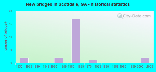
- New bridges - historical statistics
- 21930-1939
- 21950-1959
- 171960-1969
- 11970-1979
- 22000-2009

- Reconstructed bridges - Historical Statistics
- 11960-1969
- 41970-1979


- Bridge Condition - Deck
- 42.9%Good
- 50.0%Satisfactory
- 7.1%Fair

- Bridge Condition - Superstructure
- 14.3%Very good
- 57.1%Good
- 28.6%Satisfactory

- Bridge Condition - Substructure
- 7.1%Very good
- 42.9%Good
- 50.0%Satisfactory

- Bridge Condition - Channel
- 8.3%Very good
- 58.3%Good
- 25.0%Satisfactory
- 8.3%Fair

- Bridge Condition - Culverts
- 70.0%Good
- 20.0%Satisfactory
- 10.0%Fair
Find on map >> Show street view
Structure Number: 890009, Location: 6.2 MI E OF DECATUR (Lat: 33.781739, Lng: -84.237547), Route carried "on" structure: State highway 10, Year Built: 1932, Year Reconstructed: 1972, Status: Open, Structure Length: 0.82m (2.69ft), Average Daily Traffic: 40,540 (year 2011), Truck Traffic: 2%, Average Future Daily Traffic: 60,810 (year 2031), Design Load: HS 20+Mod, Features Intersected: INDIAN CREEK, Facility Carried by Structure: MEMORIAL DRIVE
Minimum Vertical Clearance: 30+ m (98+ ft), Kilometerpoint: 9.656, Lanes on structure: 7, Base Highway Network: Yes, Owner: State Highway Agency, Approaching Roadway Width: 25.6m (84.0ft), Skew: 9 degrees, Material/Design: Concrete, Design/Construction: Culvert, Number Of Spans In Main Unit: 2, Length of Maximum Span: 4.0m (13.1ft)
Condition: Channel: Very good, Culverts: Fair, Structural Evaluation: Somewhat better than minimum adequacy, Waterway Adequacy: Equal to present desirable criteria, Approach Roadway Alignment: Equal to present desirable criteria, Designated Inspection Frequency: Every 24 months, Inspection Date: May 2020, Bridge Improvement Cost: $249,000, Roadway Improvement Cost: $25,000, Total Project Cost: $374,000
Find on map >> Show street view
Structure Number: 890085, Location: 0.8 MI NW OF CLARKSTON (Lat: 33.815758, Lng: -84.251739), Route carried "on" structure: Interstate 285, Year Built: 1967, Year Reconstructed: 1983, Status: Open, Structure Length: 8.02m (26.31ft), Average Daily Traffic: 183,890 (year 2011), Truck Traffic: 1%, Average Future Daily Traffic: 275,835 (year 2031), Design Load: HS 20+Mod, Features Intersected: SR 410 STONE MT FREEWAY
Minimum Vertical Clearance: 30+ m (98+ ft), Kilometerpoint: 61.155, Lanes on structure: 5, Lanes under structure: 6, Base Highway Network: Yes, Owner: State Highway Agency, Approaching Roadway Width: 26.8m (87.9ft), Skew: 12 degrees, Material/Design: Steel, Design/Construction: Stringer/Multi-beam, Number Of Spans In Main Unit: 4, Length of Maximum Span: 25.3m (83.0ft), Curb-To-Curb Width: 28.7m (94.2ft), Out-to-Out Width: 29.7m (97.4ft)
Condition: Deck: Good, Superstructure: Good, Substructure: Good, Operating Rating: 29.0 metric tons, Method Used To Determine Operating Rating: Load Factor (LF), Inventory Rating: 17.2 metric tons, Method Used To Determine Inventory Rating: Load Factor (LF), Structural Evaluation: Meets minimum limits, Deck Geometry: Superior to present desirable criteria, Underclear: High priority of corrective action, Approach Roadway Alignment: Equal to present desirable criteria, Designated Inspection Frequency: Every 24 months, Inspection Date: May 2020, Bridge Improvement Cost: $1,868,000, Roadway Improvement Cost: $187,000, Total Project Cost: $2,803,000, Deck Structure Type: Concrete Cast-file-Place
Find on map >> Show street view
Structure Number: 890086, Location: 0.8 MI NW OF CLARKSTON (Lat: 33.816419, Lng: -84.250697), Route carried "on" structure: Interstate 285, Year Built: 1967, Year Reconstructed: 1983, Status: Open, Structure Length: 7.89m (25.89ft), Average Daily Traffic: 183,890 (year 2011), Truck Traffic: 1%, Average Future Daily Traffic: 275,835 (year 2031), Design Load: HS 20+Mod, Features Intersected: SR 410 STONE MT FREEWAY
Minimum Vertical Clearance: 30+ m (98+ ft), Kilometerpoint: 62.764, Lanes on structure: 5, Lanes under structure: 7, Base Highway Network: Yes, Owner: State Highway Agency, Approaching Roadway Width: 28.0m (91.9ft), Skew: 12 degrees, Material/Design: Steel, Design/Construction: Stringer/Multi-beam, Number Of Spans In Main Unit: 4, Length of Maximum Span: 24.1m (79.1ft), Curb-To-Curb Width: 30.3m (99.4ft), Out-to-Out Width: 33.5m (109.9ft)
Condition: Deck: Good, Superstructure: Satisfactory, Substructure: Satisfactory, Operating Rating: 28.1 metric tons, Method Used To Determine Operating Rating: Load Factor (LF), Inventory Rating: 16.3 metric tons, Method Used To Determine Inventory Rating: Load Factor (LF), Structural Evaluation: Meets minimum limits, Deck Geometry: Superior to present desirable criteria, Underclear: High priority of corrective action, Approach Roadway Alignment: Equal to present desirable criteria, Designated Inspection Frequency: Every 24 months, Inspection Date: June 2020, Bridge Improvement Cost: $1,840,000, Roadway Improvement Cost: $184,000, Total Project Cost: $2,760,000, Deck Structure Type: Concrete Cast-file-Place, Wearing Surface/Protective System: Wearing Surface: Epoxy Overlay
Find on map >> Show street view
Structure Number: 890087, Location: 0.8 MI NW OF CLARKSTON (Lat: 33.813508, Lng: -84.251497), Route carried "on" structure: Interstate 285, Year Built: 1968, Year Reconstructed: 1981, Status: Open, Structure Length: 4.91m (16.11ft), Average Daily Traffic: 183,890 (year 2011), Truck Traffic: 1%, Average Future Daily Traffic: 275,835 (year 2031), Design Load: HS 20+Mod, Features Intersected: SR 410 RAMP TO I-285
Minimum Vertical Clearance: 30+ m (98+ ft), Kilometerpoint: 62.764, Lanes on structure: 4, Lanes under structure: 1, Base Highway Network: Yes, Owner: State Highway Agency, Approaching Roadway Width: 24.4m (80.1ft), Skew: 13 degrees, Material/Design: Steel, Design/Construction: Stringer/Multi-beam, Number Of Spans In Main Unit: 3, Length of Maximum Span: 20.1m (65.9ft), Curb-To-Curb Width: 25.0m (82.0ft), Out-to-Out Width: 26.0m (85.3ft)
Condition: Deck: Satisfactory, Superstructure: Good, Substructure: Satisfactory, Operating Rating: 43.5 metric tons, Method Used To Determine Operating Rating: Load Factor (LF), Inventory Rating: 26.3 metric tons, Method Used To Determine Inventory Rating: Load Factor (LF), Structural Evaluation: Equal to present minimum criteria, Deck Geometry: Superior to present desirable criteria, Underclear: Superior to present desirable criteria, Approach Roadway Alignment: Equal to present desirable criteria, Designated Inspection Frequency: Every 24 months, Inspection Date: June 2020, Bridge Improvement Cost: $972,000, Roadway Improvement Cost: $97,000, Total Project Cost: $1,458,000, Deck Structure Type: Concrete Cast-file-Place
Find on map >> Show street view
Structure Number: 890088, Location: .7 MI W OF CLARKSTON (Lat: 33.808428, Lng: -84.250889), Route carried "on" structure: Interstate 285, Year Built: 1970, Status: Open, Structure Length: 1.37m (4.49ft), Average Daily Traffic: 183,890 (year 2011), Truck Traffic: 1%, Average Future Daily Traffic: 275,835 (year 2031), Design Load: HS 20+Mod, Features Intersected: S FORK PEACHTREE CREEK
Minimum Vertical Clearance: 30+ m (98+ ft), Kilometerpoint: 62.764, Lanes on structure: 10, Base Highway Network: Yes, Owner: State Highway Agency, Approaching Roadway Width: 47.2m (154.9ft), Skew: 30 degrees, Material/Design: Concrete, Design/Construction: Culvert, Number Of Spans In Main Unit: 4, Length of Maximum Span: 3.0m (9.8ft)
Condition: Channel: Good, Culverts: Satisfactory, Structural Evaluation: Equal to present minimum criteria, Waterway Adequacy: Superior to present desirable criteria, Approach Roadway Alignment: Equal to present desirable criteria, Designated Inspection Frequency: Every 24 months, Inspection Date: May 2020, Bridge Improvement Cost: $559,000, Roadway Improvement Cost: $56,000, Total Project Cost: $839,000
Find on map >> Show street view
Structure Number: 890089, Location: 2.7 MI S OF CLARKSTON (Lat: 33.786969, Lng: -84.246333), Route carried "on" structure: Interstate 285, Year Built: 1966, Year Reconstructed: 1981, Status: Open, Structure Length: 5.21m (17.09ft), Average Daily Traffic: 181,310 (year 2011), Truck Traffic: 10%, Average Future Daily Traffic: 271,965 (year 2031), Design Load: HS 20+Mod, Features Intersected: M-9011 N. DECATUR ROAD
Minimum Vertical Clearance: 30+ m (98+ ft), Kilometerpoint: 64.374, Lanes on structure: 8, Lanes under structure: 5, Base Highway Network: Yes, Owner: State Highway Agency, Approaching Roadway Width: 39.0m (128.0ft), Skew: 34 degrees, Material/Design: Steel, Design/Construction: Stringer/Multi-beam, Number Of Spans In Main Unit: 3, Length of Maximum Span: 26.8m (87.9ft), Curb-To-Curb Width: 44.2m (145.0ft), Out-to-Out Width: 45.1m (148.0ft)
Condition: Deck: Satisfactory, Superstructure: Good, Substructure: Satisfactory, Operating Rating: 34.4 metric tons, Method Used To Determine Operating Rating: Load Factor (LF), Inventory Rating: 20.8 metric tons, Method Used To Determine Inventory Rating: Load Factor (LF), Structural Evaluation: Somewhat better than minimum adequacy, Deck Geometry: Superior to present desirable criteria, Underclear: High priority of corrective action, Approach Roadway Alignment: Equal to present desirable criteria, Designated Inspection Frequency: Every 24 months, Inspection Date: May 2020, Bridge Improvement Cost: $1,761,000, Roadway Improvement Cost: $176,000, Total Project Cost: $2,642,000, Deck Structure Type: Concrete Cast-file-Place
Find on map >> Show street view
Structure Number: 89009, Location: .8 MI SW OF CLARKSTON (Lat: 33.786081, Lng: -84.246236), Route carried "on" structure: Interstate 285, Year Built: 1965, Status: Open, Structure Length: 0.85m (2.79ft), Average Daily Traffic: 181,310 (year 2011), Truck Traffic: 10%, Average Future Daily Traffic: 271,965 (year 2031), Design Load: HS 20+Mod, Features Intersected: INDIAN CREEK
Minimum Vertical Clearance: 30+ m (98+ ft), Kilometerpoint: 64.374, Lanes on structure: 8, Base Highway Network: Yes, Owner: State Highway Agency, Approaching Roadway Width: 39.0m (128.0ft), Skew: 33 degrees, Material/Design: Concrete, Design/Construction: Culvert, Number Of Spans In Main Unit: 3, Length of Maximum Span: 2.7m (8.9ft)
Condition: Channel: Satisfactory, Culverts: Satisfactory, Structural Evaluation: Equal to present minimum criteria, Waterway Adequacy: Equal to present minimum criteria, Approach Roadway Alignment: Equal to present desirable criteria, Designated Inspection Frequency: Every 24 months, Inspection Date: May 2020, Bridge Improvement Cost: $288,000, Roadway Improvement Cost: $29,000, Total Project Cost: $433,000
Find on map >> Show street view
Structure Number: 890107, Location: 1.7 MI W CLARSKTON (Lat: 33.809039, Lng: -84.269489), Route carried "on" structure: US 78, Year Built: 1968, Status: Open, Structure Length: 5.49m (18.01ft), Average Daily Traffic: 71,220 (year 2011), Truck Traffic: 1%, Average Future Daily Traffic: 106,830 (year 2031), Design Load: HS 20+Mod, Features Intersected: M-9218 VALLEY BROOK RD
Minimum Vertical Clearance: 30+ m (98+ ft), Kilometerpoint: 9.656, Lanes on structure: 2, Lanes under structure: 5, Base Highway Network: Yes, Owner: State Highway Agency, Approaching Roadway Width: 11.6m (38.1ft), Skew: 13 degrees, Material/Design: Steel, Design/Construction: Stringer/Multi-beam, Number Of Spans In Main Unit: 3, Length of Maximum Span: 30.2m (99.1ft), Curb-To-Curb Width: 11.9m (39.0ft), Out-to-Out Width: 12.6m (41.3ft)
Condition: Deck: Satisfactory, Superstructure: Good, Substructure: Satisfactory, Operating Rating: 29.0 metric tons, Method Used To Determine Operating Rating: Load Factor (LF), Inventory Rating: 17.2 metric tons, Method Used To Determine Inventory Rating: Load Factor (LF), Structural Evaluation: Meets minimum limits, Deck Geometry: Equal to present minimum criteria, Underclear: Somewhat better than minimum adequacy, Approach Roadway Alignment: Equal to present desirable criteria, Designated Inspection Frequency: Every 24 months, Inspection Date: May 2020, Bridge Improvement Cost: $703,000, Roadway Improvement Cost: $70,000, Total Project Cost: $1,055,000, Deck Structure Type: Concrete Cast-file-Place
Find on map >> Show street view
Structure Number: 890108, Location: 2.1 MI W OF CLARKSTON (Lat: 33.809447, Lng: -84.270419), Route carried "on" structure: US 78, Year Built: 1968, Status: Open, Structure Length: 5.97m (19.59ft), Average Daily Traffic: 71,220 (year 2011), Truck Traffic: 1%, Average Future Daily Traffic: 106,830 (year 2031), Design Load: HS 20+Mod, Features Intersected: M-9218 VALLEY BROOK RD
Minimum Vertical Clearance: 30+ m (98+ ft), Kilometerpoint: 9.656, Lanes on structure: 2, Lanes under structure: 3, Base Highway Network: Yes, Owner: State Highway Agency, Approaching Roadway Width: 11.6m (38.1ft), Skew: 14 degrees, Material/Design: Steel, Design/Construction: Stringer/Multi-beam, Number Of Spans In Main Unit: 3, Length of Maximum Span: 35.1m (115.2ft), Curb-To-Curb Width: 13.0m (42.7ft), Out-to-Out Width: 13.7m (44.9ft)
Condition: Deck: Satisfactory, Superstructure: Good, Substructure: Satisfactory, Operating Rating: 37.1 metric tons, Method Used To Determine Operating Rating: Load Factor (LF), Inventory Rating: 21.7 metric tons, Method Used To Determine Inventory Rating: Load Factor (LF), Structural Evaluation: Somewhat better than minimum adequacy, Deck Geometry: Superior to present desirable criteria, Underclear: Somewhat better than minimum adequacy, Approach Roadway Alignment: Equal to present desirable criteria, Designated Inspection Frequency: Every 24 months, Inspection Date: May 2020, Bridge Improvement Cost: $766,000, Roadway Improvement Cost: $77,000, Total Project Cost: $1,149,000, Deck Structure Type: Concrete Cast-file-Place
Find on map >> Show street view
Structure Number: 890109, Location: 1.1 MI W OF CLARKSTON (Lat: 33.810489, Lng: -84.264028), Route carried "on" structure: US 78, Year Built: 1968, Status: Open, Structure Length: 1.52m (4.99ft), Average Daily Traffic: 74,660 (year 2011), Truck Traffic: 1%, Average Future Daily Traffic: 111,990 (year 2031), Design Load: HS 20+Mod, Features Intersected: S FORK PEACHTREE CREEK, Facility Carried by Structure: STONE MTN. FWY.
Minimum Vertical Clearance: 30+ m (98+ ft), Kilometerpoint: 9.656, Lanes on structure: 7, Base Highway Network: Yes, Owner: State Highway Agency, Approaching Roadway Width: 34.1m (111.9ft), Skew: 13 degrees, Material/Design: Concrete, Design/Construction: Culvert, Number Of Spans In Main Unit: 4, Length of Maximum Span: 3.7m (12.1ft)
Condition: Channel: Good, Culverts: Good, Structural Evaluation: Better than present minimum criteria, Waterway Adequacy: Equal to present minimum criteria, Approach Roadway Alignment: Equal to present desirable criteria, Designated Inspection Frequency: Every 24 months, Inspection Date: May 2020, Bridge Improvement Cost: $462,000, Roadway Improvement Cost: $46,000, Total Project Cost: $693,000
Find on map >> Show street view
Structure Number: 89011, Location: 1.4 MI W OF CLARKSTON (Lat: 33.812053, Lng: -84.258917), Route carried "on" structure: US 78, Year Built: 1968, Status: Open, Structure Length: 1.34m (4.40ft), Average Daily Traffic: 74,660 (year 2011), Truck Traffic: 1%, Average Future Daily Traffic: 111,990 (year 2031), Design Load: HS 20+Mod, Features Intersected: S FORK PEACHTREE CREEK, Facility Carried by Structure: STONE MTN. FWY.
Minimum Vertical Clearance: 30+ m (98+ ft), Kilometerpoint: 9.656, Lanes on structure: 8, Base Highway Network: Yes, Owner: State Highway Agency, Approaching Roadway Width: 36.6m (120.1ft), Skew: 10 degrees, Material/Design: Concrete, Design/Construction: Culvert, Number Of Spans In Main Unit: 4, Length of Maximum Span: 3.0m (9.8ft)
Condition: Channel: Good, Culverts: Good, Operating Rating: 55.3 metric tons, Method Used To Determine Operating Rating: Field evaluation and documented engineering judgment, Inventory Rating: 32.6 metric tons, Method Used To Determine Inventory Rating: Field evaluation and documented engineering judgment, Structural Evaluation: Better than present minimum criteria, Waterway Adequacy: Equal to present minimum criteria, Approach Roadway Alignment: Equal to present desirable criteria, Designated Inspection Frequency: Every 24 months, Inspection Date: May 2020, Bridge Improvement Cost: $453,000, Roadway Improvement Cost: $45,000, Total Project Cost: $680,000
Find on map >> Show street view
Structure Number: 890117, Location: 0.8 MI SW OF CLARKSTON (Lat: 33.802753, Lng: -84.250058), Route carried "on" structure: County highway 839, Year Built: 1966, Status: Open, Structure Length: 7.35m (24.11ft), Average Daily Traffic: 2,202 (year 2011), Truck Traffic: 1%, Average Future Daily Traffic: 3,303 (year 2031), Design Load: HS 20+Mod, Features Intersected: I-285 (SR 407), Facility Carried by Structure: CHURCH STREET
Minimum Vertical Clearance: 30+ m (98+ ft), Kilometerpoint: 1.609, Lanes on structure: 2, Lanes under structure: 8, Base Highway Network: Yes, Owner: State Highway Agency, Approaching Roadway Width: 9.1m (29.9ft), Skew: 1 degrees, Material/Design: Steel continuous, Design/Construction: Stringer/Multi-beam, Number Of Spans In Main Unit: 4, Length of Maximum Span: 21.3m (69.9ft), Curb or Sidewalk Widths: Left: 0.6m (2.0ft), Right: 1.5m (4.9ft), Curb-To-Curb Width: 9.1m (29.9ft), Out-to-Out Width: 11.9m (39.0ft)
Condition: Deck: Satisfactory, Superstructure: Satisfactory, Substructure: Good, Operating Rating: 36.2 metric tons, Method Used To Determine Operating Rating: Allowable Stress (AS), Inventory Rating: 21.7 metric tons, Method Used To Determine Inventory Rating: Allowable Stress (AS), Structural Evaluation: Somewhat better than minimum adequacy, Deck Geometry: Meets minimum limits, Underclear: Meets minimum limits, Approach Roadway Alignment: Better than present minimum criteria, Designated Inspection Frequency: Every 24 months, Inspection Date: July 2020, Bridge Improvement Cost: $942,000, Roadway Improvement Cost: $94,000, Total Project Cost: $1,412,000, Deck Structure Type: Concrete Cast-file-Place
Find on map >> Show street view
Structure Number: 890118, Location: 2.8 MI S OF CLARKSTON (Lat: 33.783119, Lng: -84.245508), Route carried "on" structure: County highway 848, Year Built: 1966, Status: Open, Structure Length: 8.29m (27.20ft), Average Daily Traffic: 2,202 (year 2011), Truck Traffic: 1%, Average Future Daily Traffic: 3,303 (year 2031), Design Load: HS 20+Mod, Features Intersected: I-285 (SR 407), Facility Carried by Structure: ROCKBRIDGE ROAD
Minimum Vertical Clearance: 30+ m (98+ ft), Kilometerpoint: 1.609, Lanes on structure: 2, Lanes under structure: 8, Base Highway Network: Yes, Owner: State Highway Agency, Approaching Roadway Width: 8.5m (27.9ft), Material/Design: Steel, Design/Construction: Stringer/Multi-beam, Number Of Spans In Main Unit: 4, Length of Maximum Span: 25.3m (83.0ft), Curb or Sidewalk Widths: Left: 1.5m (4.9ft), Right: 0.6m (2.0ft), Curb-To-Curb Width: 8.5m (27.9ft), Out-to-Out Width: 10.9m (35.8ft)
Condition: Deck: Satisfactory, Superstructure: Satisfactory, Substructure: Satisfactory, Operating Rating: 39.9 metric tons, Method Used To Determine Operating Rating: Load Factor (LF), Inventory Rating: 23.5 metric tons, Method Used To Determine Inventory Rating: Load Factor (LF), Structural Evaluation: Equal to present minimum criteria, Deck Geometry: Meets minimum limits, Underclear: Meets minimum limits, Approach Roadway Alignment: Better than present minimum criteria, Designated Inspection Frequency: Every 24 months, Inspection Date: May 2020, Bridge Improvement Cost: $1,063,000, Roadway Improvement Cost: $106,000, Total Project Cost: $1,594,000, Deck Structure Type: Concrete Cast-file-Place
Find on map >> Show street view
Structure Number: 890138, Location: 0.8 MI SW OF CLARKSTON (Lat: 33.803217, Lng: -84.250117), Route carried "on" structure: City street 9012, Year Built: 1966, Status: Open, Structure Length: 7.44m (24.41ft), Average Daily Traffic: 11,190 (year 2011), Truck Traffic: 1%, Average Future Daily Traffic: 16,785 (year 2031), Design Load: HS 20+Mod, Features Intersected: I-285 (SR 407), Facility Carried by Structure: E. PONCE DE LEON
Minimum Vertical Clearance: 30+ m (98+ ft), Kilometerpoint: 8.047, Lanes on structure: 4, Lanes under structure: 8, Base Highway Network: Yes, Owner: State Highway Agency, Approaching Roadway Width: 7.3m (24.0ft), Skew: 1 degrees, Material/Design: Steel continuous, Design/Construction: Stringer/Multi-beam, Number Of Spans In Main Unit: 4, Length of Maximum Span: 21.3m (69.9ft), Curb or Sidewalk Widths: Left: 1.6m (5.2ft), Right: 0.6m (2.0ft), Curb-To-Curb Width: 15.8m (51.8ft), Out-to-Out Width: 18.2m (59.7ft)
Condition: Deck: Satisfactory, Superstructure: Satisfactory, Substructure: Satisfactory, Operating Rating: 35.3 metric tons, Method Used To Determine Operating Rating: Load Factor (LF), Inventory Rating: 20.8 metric tons, Method Used To Determine Inventory Rating: Load Factor (LF), Structural Evaluation: Somewhat better than minimum adequacy, Deck Geometry: Meets minimum limits, Underclear: Meets minimum limits, Approach Roadway Alignment: Better than present minimum criteria, Designated Inspection Frequency: Every 24 months, Inspection Date: July 2020, Bridge Improvement Cost: $1,473,000, Roadway Improvement Cost: $147,000, Total Project Cost: $2,210,000, Deck Structure Type: Concrete Cast-file-Place
Find on map >> Show street view
Structure Number: 890174, Location: 1.6 MI W OF CLARKSTON (Lat: 33.808244, Lng: -84.268722), Route carried "on" structure: City street 9218, Year Built: 1968, Status: Open, Structure Length: 1.37m (4.49ft), Average Daily Traffic: 9,990 (year 2011), Truck Traffic: 1%, Average Future Daily Traffic: 14,985 (year 2031), Design Load: HS 20+Mod, Features Intersected: S FORK PEACHTREE CREEK, Facility Carried by Structure: VALLEY BROOK ROAD
Minimum Vertical Clearance: 30+ m (98+ ft), Kilometerpoint: 1.609, Lanes on structure: 4, Base Highway Network: Yes, Owner: County Highway Agency, Approaching Roadway Width: 18.3m (60.0ft), Material/Design: Concrete, Design/Construction: Culvert, Number Of Spans In Main Unit: 4, Length of Maximum Span: 3.0m (9.8ft)
Condition: Channel: Good, Culverts: Good, Operating Rating: 55.3 metric tons, Method Used To Determine Operating Rating: Field evaluation and documented engineering judgment, Inventory Rating: 32.6 metric tons, Method Used To Determine Inventory Rating: Field evaluation and documented engineering judgment, Structural Evaluation: Better than present minimum criteria, Waterway Adequacy: Equal to present desirable criteria, Approach Roadway Alignment: Equal to present desirable criteria, Designated Inspection Frequency: Every 24 months, Inspection Date: May 2020, Bridge Improvement Cost: $272,000, Roadway Improvement Cost: $27,000, Total Project Cost: $408,000
Find on map >> Show street view
Structure Number: 890182, Location: 1.2 MI W OF CLARKSTON (Lat: 33.811469, Lng: -84.260639), Route carried "on" structure: City street 9227, Year Built: 1968, Status: Open, Structure Length: 8.47m (27.79ft), Average Daily Traffic: 3,150 (year 2011), Truck Traffic: 1%, Average Future Daily Traffic: 4,725 (year 2031), Design Load: HS 20+Mod, Features Intersected: SR 410 STONE MTN FREEWAY, Facility Carried by Structure: MCLENDON ROAD
Minimum Vertical Clearance: 30+ m (98+ ft), Kilometerpoint: 1.609, Lanes on structure: 2, Lanes under structure: 7, Base Highway Network: Yes, Owner: State Highway Agency, Approaching Roadway Width: 9.1m (29.9ft), Skew: 2 degrees, Material/Design: Steel continuous, Design/Construction: Stringer/Multi-beam, Number Of Spans In Main Unit: 4, Length of Maximum Span: 24.4m (80.1ft), Curb or Sidewalk Widths: Left: 1.3m (4.3ft), Right: 1.5m (4.9ft), Curb-To-Curb Width: 8.4m (27.6ft), Out-to-Out Width: 11.8m (38.7ft)
Condition: Deck: Good, Superstructure: Very good, Substructure: Good, Operating Rating: 68.0 metric tons, Method Used To Determine Operating Rating: Load Factor (LF), Inventory Rating: 40.8 metric tons, Method Used To Determine Inventory Rating: Load Factor (LF), Structural Evaluation: Better than present minimum criteria, Deck Geometry: High priority of corrective action, Underclear: Equal to present minimum criteria, Approach Roadway Alignment: Equal to present minimum criteria, Designated Inspection Frequency: Every 24 months, Inspection Date: May 2020, Bridge Improvement Cost: $1,086,000, Roadway Improvement Cost: $109,000, Total Project Cost: $1,629,000, Deck Structure Type: Concrete Cast-file-Place
Find on map >> Show street view
Structure Number: 890183, Location: 1.2 MI W OF CLARKSTON (Lat: 33.812742, Lng: -84.260644), Route carried "on" structure: City street 9227, Year Built: 1960, Status: Open, Structure Length: 1.01m (3.31ft), Average Daily Traffic: 3,150 (year 2011), Truck Traffic: 1%, Average Future Daily Traffic: 4,725 (year 2031), Design Load: H 15, Features Intersected: S FORK PEACHTREE CREEK, Facility Carried by Structure: MCCLENDON ROAD
Minimum Vertical Clearance: 30+ m (98+ ft), Kilometerpoint: 1.609, Lanes on structure: 2, Base Highway Network: Yes, Owner: County Highway Agency, Approaching Roadway Width: 7.9m (25.9ft), Skew: 1 degrees, Material/Design: Concrete, Design/Construction: Culvert, Number Of Spans In Main Unit: 3, Length of Maximum Span: 3.0m (9.8ft), Curb or Sidewalk Widths: Left: 0.0m, Right: 1.5m (4.9ft)
Condition: Channel: Good, Culverts: Good, Operating Rating: 41.7 metric tons, Method Used To Determine Operating Rating: Field evaluation and documented engineering judgment, Inventory Rating: 24.4 metric tons, Method Used To Determine Inventory Rating: Field evaluation and documented engineering judgment, Structural Evaluation: Equal to present minimum criteria, Waterway Adequacy: Equal to present desirable criteria, Approach Roadway Alignment: Equal to present minimum criteria, Designated Inspection Frequency: Every 24 months, Inspection Date: May 2020, Bridge Improvement Cost: $129,000, Roadway Improvement Cost: $13,000, Total Project Cost: $193,000
Find on map >> Show street view
Structure Number: 895028, Location: 2 MI S OF CLARKSTON (Lat: 33.778928, Lng: -84.237258), Route carried "on" structure: County highway 801, Year Built: 1957, Status: Open, Structure Length: 1.10m (3.61ft), Average Daily Traffic: 2,202 (year 2011), Truck Traffic: 1%, Average Future Daily Traffic: 3,303 (year 2031), Design Load: H 15, Features Intersected: INDIAN CREEK, Facility Carried by Structure: KINGWOODS DRIVE
Minimum Vertical Clearance: 30+ m (98+ ft), Kilometerpoint: 0.000, Lanes on structure: 2, Base Highway Network: Yes, Owner: County Highway Agency, Approaching Roadway Width: 8.2m (26.9ft), Material/Design: Concrete, Design/Construction: Culvert, Number Of Spans In Main Unit: 4, Length of Maximum Span: 2.4m (7.9ft)
Condition: Channel: Good, Culverts: Good, Operating Rating: 43.5 metric tons, Method Used To Determine Operating Rating: Field evaluation and documented engineering judgment, Inventory Rating: 24.4 metric tons, Method Used To Determine Inventory Rating: Field evaluation and documented engineering judgment, Structural Evaluation: Equal to present minimum criteria, Waterway Adequacy: Better than present minimum criteria, Approach Roadway Alignment: Equal to present desirable criteria, Designated Inspection Frequency: Every 24 months, Inspection Date: May 2020, Bridge Improvement Cost: $141,000, Roadway Improvement Cost: $14,000, Total Project Cost: $211,000
Find on map >> Show street view
Structure Number: 895029, Location: 1.1 MI W OF CLARKSTON (Lat: 33.808339, Lng: -84.268197), Route carried "on" structure: County highway 948, Year Built: 1964, Status: Open, Structure Length: 1.58m (5.18ft), Average Daily Traffic: 2,202 (year 2011), Truck Traffic: 1%, Average Future Daily Traffic: 3,303 (year 2031), Design Load: H 15, Features Intersected: S FORK PEACHTREE CREEK, Facility Carried by Structure: CEDAR CREEK DRIVE
Minimum Vertical Clearance: 30+ m (98+ ft), Kilometerpoint: 1.609, Lanes on structure: 2, Base Highway Network: Yes, Owner: County Highway Agency, Approaching Roadway Width: 7.6m (24.9ft), Material/Design: Steel, Design/Construction: Culvert, Number Of Spans In Main Unit: 6, Length of Maximum Span: 1.8m (5.9ft)
Condition: Channel: Satisfactory, Culverts: Good, Operating Rating: 41.7 metric tons, Method Used To Determine Operating Rating: Field evaluation and documented engineering judgment, Inventory Rating: 24.4 metric tons, Method Used To Determine Inventory Rating: Field evaluation and documented engineering judgment, Structural Evaluation: Equal to present minimum criteria, Waterway Adequacy: Equal to present desirable criteria, Approach Roadway Alignment: Equal to present minimum criteria, Designated Inspection Frequency: Every 24 months, Inspection Date: May 2020, Bridge Improvement Cost: $203,000, Roadway Improvement Cost: $20,000, Total Project Cost: $305,000
Find on map >> Show street view
Structure Number: 895061, Location: .75 MI W OF CLARKSTON (Lat: 33.808569, Lng: -84.252797), Route carried "on" structure: County highway 2167, Year Built: 1956, Status: Open, Structure Length: 2.47m (8.10ft), Average Daily Traffic: 2,202 (year 2011), Truck Traffic: 1%, Average Future Daily Traffic: 3,303 (year 2031), Design Load: H 15, Features Intersected: S FORK PEACHTREE CREEK, Facility Carried by Structure: CREEKDALE DRIVE
Minimum Vertical Clearance: 30+ m (98+ ft), Kilometerpoint: 0.000, Lanes on structure: 2, Base Highway Network: Yes, Owner: County Highway Agency, Approaching Roadway Width: 7.9m (25.9ft), Skew: 4 degrees, Material/Design: Steel continuous, Design/Construction: Stringer/Multi-beam, Number Of Spans In Main Unit: 3, Length of Maximum Span: 8.2m (26.9ft), Curb or Sidewalk Widths: Left: 0.8m (2.6ft), Right: 0.8m (2.6ft), Curb-To-Curb Width: 8.1m (26.6ft), Out-to-Out Width: 9.8m (32.2ft)
Condition: Deck: Fair, Superstructure: Good, Substructure: Good, Channel: Good, Operating Rating: 39.9 metric tons, Method Used To Determine Operating Rating: Load Factor (LF), Inventory Rating: 23.5 metric tons, Method Used To Determine Inventory Rating: Load Factor (LF), Structural Evaluation: Equal to present minimum criteria, Deck Geometry: High priority of corrective action, Waterway Adequacy: Equal to present minimum criteria, Approach Roadway Alignment: Equal to present minimum criteria, Length Of Structure Improvement: 43.89m (144.00ft), Designated Inspection Frequency: Every 24 months, Inspection Date: May 2020, Bridge Improvement Cost: $316,000, Roadway Improvement Cost: $32,000, Total Project Cost: $475,000, Deck Structure Type: Concrete Cast-file-Place
Find on map >> Show street view
Structure Number: 895068, Location: 1.5 MI SW OF CLARKSTON (Lat: 33.804328, Lng: -84.276169), Route carried "on" structure: County highway 3078, Year Built: 1967, Status: Posted for load, Structure Length: 3.66m (12.01ft), Average Daily Traffic: 2,202 (year 2011), Truck Traffic: 1%, Average Future Daily Traffic: 3,303 (year 2031), Design Load: HS 15, Features Intersected: S FORK PEACHTREE CREEK, Facility Carried by Structure: RT. FRONTAGE ROAD
Minimum Vertical Clearance: 30+ m (98+ ft), Kilometerpoint: 0.000, Lanes on structure: 2, Base Highway Network: Yes, Owner: County Highway Agency, Approaching Roadway Width: 6.1m (20.0ft), Material/Design: Concrete, Design/Construction: Tee Beam, Number Of Spans In Main Unit: 3, Length of Maximum Span: 12.2m (40.0ft), Curb or Sidewalk Widths: Left: 0.7m (2.3ft), Right: 1.2m (3.9ft), Curb-To-Curb Width: 7.3m (24.0ft), Out-to-Out Width: 10.0m (32.8ft)
Condition: Deck: Good, Superstructure: Good, Substructure: Good, Channel: Satisfactory, Operating Rating: 29.9 metric tons, Method Used To Determine Operating Rating: Load Factor (LF), Inventory Rating: 13.6 metric tons, Method Used To Determine Inventory Rating: Load Factor (LF), Structural Evaluation: Meets minimum limits, Deck Geometry: High priority of replacement, Waterway Adequacy: Equal to present desirable criteria, Approach Roadway Alignment: Equal to present desirable criteria, Bridge Posting: Required (Relationship of Operating Rating to Maximum Legal Load: 0.1 - 9.9% below), Length Of Structure Improvement: 10.09m (33.10ft), Designated Inspection Frequency: Every 24 months, Inspection Date: May 2020, Bridge Improvement Cost: $469,000, Roadway Improvement Cost: $47,000, Total Project Cost: $703,000, Deck Structure Type: Concrete Cast-file-Place
Find on map >> Show street view
Structure Number: 895121, Location: 2 MI E OF AVONDALE EST. (Lat: 33.782428, Lng: -84.240458), Route carried "on" structure: County highway 848, Year Built: 1936, Status: Open, Structure Length: 0.73m (2.40ft), Average Daily Traffic: 2,202 (year 2011), Truck Traffic: 1%, Average Future Daily Traffic: 3,303 (year 2031), Design Load: H 15, Features Intersected: INDIAN CREEK, Facility Carried by Structure: ROCKBRIDGE ROAD
Minimum Vertical Clearance: 30+ m (98+ ft), Kilometerpoint: 0.000, Lanes on structure: 2, Base Highway Network: Yes, Owner: County Highway Agency, Approaching Roadway Width: 7.3m (24.0ft), Skew: 4 degrees, Material/Design: Masonry, Design/Construction: Culvert, Number Of Spans In Main Unit: 2, Length of Maximum Span: 3.4m (11.2ft)
Condition: Channel: Fair, Culverts: Good, Operating Rating: 41.7 metric tons, Method Used To Determine Operating Rating: Field evaluation and documented engineering judgment, Inventory Rating: 24.4 metric tons, Method Used To Determine Inventory Rating: Field evaluation and documented engineering judgment, Structural Evaluation: Equal to present minimum criteria, Waterway Adequacy: Equal to present minimum criteria, Approach Roadway Alignment: Better than present minimum criteria, Designated Inspection Frequency: Every 24 months, Inspection Date: May 2020, Bridge Improvement Cost: $94,000, Roadway Improvement Cost: $9,000, Total Project Cost: $141,000
Find on map >> Show street view
Structure Number: 895162, Location: 5 MI E OF DECATUR (Lat: 33.778183, Lng: -84.241281), Route carried "on" structure: State highway 10, Year Built: 2008, Status: Open, Structure Length: 11.70m (38.39ft), Average Daily Traffic: 40,540 (year 2011), Truck Traffic: 2%, Average Future Daily Traffic: 60,810 (year 2031), Design Load: HS 20+Mod, Features Intersected: I-285 (SR 407), Facility Carried by Structure: MEMORIAL DRIVE
Minimum Vertical Clearance: 30+ m (98+ ft), Kilometerpoint: 9.656, Lanes on structure: 10, Lanes under structure: 8, Base Highway Network: Yes, Owner: State Highway Agency, Approaching Roadway Width: 39.0m (128.0ft), Skew: 22 degrees, Material/Design: Prestressed concrete, Design/Construction: Stringer/Multi-beam, Number Of Spans In Main Unit: 4, Length of Maximum Span: 36.6m (120.1ft), Curb or Sidewalk Widths: Left: 3.7m (12.1ft), Right: 3.7m (12.1ft), Curb-To-Curb Width: 40.2m (131.9ft), Out-to-Out Width: 48.3m (158.5ft)
Condition: Deck: Good, Superstructure: Very good, Substructure: Good, Operating Rating: 46.2 metric tons, Method Used To Determine Operating Rating: Allowable Stress (AS), Inventory Rating: 32.6 metric tons, Method Used To Determine Inventory Rating: Allowable Stress (AS), Structural Evaluation: Better than present minimum criteria, Deck Geometry: Somewhat better than minimum adequacy, Underclear: High priority of corrective action, Approach Roadway Alignment: Equal to present desirable criteria, Designated Inspection Frequency: Every 24 months, Inspection Date: May 2020, Bridge Improvement Cost: $4,774,000, Roadway Improvement Cost: $477,000, Total Project Cost: $7,161,000, Deck Structure Type: Concrete Cast-file-Place, Wearing Surface/Protective System: Deck Protection: Epoxy Coated Reinforcing
Find on map >> Show street view
Structure Number: 895163, Location: 0.8 MI NW OF CLARKSTON (Lat: 33.815669, Lng: -84.252058), Route carried "on" structure: Ramp Interstate 407, Year Built: 2002, Status: Open, Structure Length: 8.38m (27.49ft), Average Daily Traffic: 18,010 (year 2011), Truck Traffic: 1%, Average Future Daily Traffic: 27,015 (year 2031), Design Load: HS 20+Mod, Features Intersected: US 78/ SR 410, Facility Carried by Structure: RAMP FOR I-285 CBL
Minimum Vertical Clearance: 30+ m (98+ ft), Kilometerpoint: 62.764, Lanes on structure: 2, Lanes under structure: 8, Base Highway Network: Yes, Owner: State Highway Agency, Approaching Roadway Width: 13.4m (44.0ft), Skew: 3 degrees, Material/Design: Prestressed concrete, Design/Construction: Stringer/Multi-beam, Number Of Spans In Main Unit: 2, Length of Maximum Span: 44.2m (145.0ft), Curb-To-Curb Width: 11.3m (37.1ft), Out-to-Out Width: 12.3m (40.4ft)
Condition: Deck: Good, Superstructure: Good, Substructure: Very good, Operating Rating: 46.2 metric tons, Method Used To Determine Operating Rating: Allowable Stress (AS), Inventory Rating: 32.6 metric tons, Method Used To Determine Inventory Rating: Allowable Stress (AS), Structural Evaluation: Better than present minimum criteria, Deck Geometry: Superior to present desirable criteria, Underclear: High priority of corrective action, Approach Roadway Alignment: Better than present minimum criteria, Designated Inspection Frequency: Every 24 months, Inspection Date: May 2020, Bridge Improvement Cost: $1,074,000, Roadway Improvement Cost: $107,000, Total Project Cost: $1,612,000, Deck Structure Type: Concrete Cast-file-Place
Find on map >> Show street view
Structure Number: 890085, Location: 0.8 MI NW OF CLARKSTON (Lat: 33.815758, Lng: -84.251739), Route carried "under" structure: US 78, Structure Length: 0. m, Average Daily Traffic: 112,900 (year 1999), Truck Traffic: 1%, Features Intersected: I-285 CBL (SR 407), Facility Carried by Structure: I-285 CBL
Minimum Vertical Clearance: 5.63m (18.47ft), Kilometerpoint: 11.265, Lanes on structure: 5, Length of Maximum Span: 0.0m
Find on map >> Show street view
Structure Number: 890086, Location: 0.8 MI NW OF CLARKSTON (Lat: 33.816419, Lng: -84.250697), Route carried "under" structure: US 78, Structure Length: 0. m, Average Daily Traffic: 112,900 (year 1999), Truck Traffic: 1%, Features Intersected: I-285 CCBL (SR 407), Facility Carried by Structure: I-285 CCBL
Minimum Vertical Clearance: 5.38m (17.65ft), Kilometerpoint: 11.265, Lanes on structure: 5, Length of Maximum Span: 0.0m
Find on map >> Show street view
Structure Number: 890087, Location: 0.8 MI NW OF CLARKSTON (Lat: 33.813508, Lng: -84.251497), Route carried "under" structure: Ramp US 78, Structure Length: 0. m, Average Daily Traffic: 7,500 (year 2009), Truck Traffic: 1%, Features Intersected: I-285 CBL (SR 407), Facility Carried by Structure: I-285 CBL
Minimum Vertical Clearance: 5.33m (17.49ft), Kilometerpoint: 11.265, Lanes on structure: 4, Length of Maximum Span: 0.0m
Find on map >> Show street view
Structure Number: 890089, Location: 2.7 MI S OF CLARKSTON (Lat: 33.786969, Lng: -84.246333), Route carried "under" structure: City street 9011, Structure Length: 0. m, Average Daily Traffic: 23,436 (year 1999), Truck Traffic: 1%, Features Intersected: I-285 (SR 407), Facility Carried by Structure: I-285
Minimum Vertical Clearance: 5.00m (16.40ft), Kilometerpoint: 9.656, Lanes on structure: 8, Length of Maximum Span: 0.0m
Find on map >> Show street view
Structure Number: 890107, Location: 1.7 MI W CLARSKTON (Lat: 33.809039, Lng: -84.269489), Route carried "under" structure: City street 9218, Structure Length: 0. m, Average Daily Traffic: 27,022 (year 1999), Truck Traffic: 1%, Features Intersected: SR 410 (US 78 EBL), Facility Carried by Structure: US 78 EBL
Minimum Vertical Clearance: 6.17m (20.24ft), Kilometerpoint: 1.609, Lanes on structure: 2, Length of Maximum Span: 0.0m
Find on map >> Show street view
Structure Number: 890108, Location: 2.1 MI W OF CLARKSTON (Lat: 33.809447, Lng: -84.270419), Route carried "under" structure: City street 9218, Structure Length: 0. m, Average Daily Traffic: 34,630 (year 1999), Truck Traffic: 1%, Features Intersected: SR 410 (US 78 WBL), Facility Carried by Structure: US 78 WBL
Minimum Vertical Clearance: 5.71m (18.73ft), Kilometerpoint: 1.609, Lanes on structure: 2, Length of Maximum Span: 0.0m
Find on map >> Show street view
Structure Number: 890117, Location: 0.8 MI SW OF CLARKSTON (Lat: 33.802753, Lng: -84.250058), Route carried "under" structure: Interstate 285, Structure Length: 0. m, Average Daily Traffic: 178,500 (year 1999), Truck Traffic: 1%, Features Intersected: CR 839 CHURCH STREET, Facility Carried by Structure: CHURCH STREET
Minimum Vertical Clearance: 5.38m (17.65ft), Kilometerpoint: 62.764, Lanes on structure: 2, Length of Maximum Span: 0.0m
Find on map >> Show street view
Structure Number: 890118, Location: 2.8 MI S OF CLARKSTON (Lat: 33.783119, Lng: -84.245508), Route carried "under" structure: Interstate 285, Structure Length: 0. m, Average Daily Traffic: 178,500 (year 1999), Truck Traffic: 1%, Features Intersected: CR 848 ROCKBRIDGE ROAD, Facility Carried by Structure: ROCKBRIDGE ROAD
Minimum Vertical Clearance: 6.24m (20.47ft), Kilometerpoint: 65.983, Lanes on structure: 2, Length of Maximum Span: 0.0m
Find on map >> Show street view
Structure Number: 890138, Location: 0.8 MI SW OF CLARKSTON (Lat: 33.803217, Lng: -84.250117), Route carried "under" structure: Interstate 285, Structure Length: 0. m, Average Daily Traffic: 181,100 (year 1999), Truck Traffic: 1%, Features Intersected: M-9012 E. PONCE DE LEON, Facility Carried by Structure: E. PONCE DE LEON
Minimum Vertical Clearance: 5.94m (19.49ft), Kilometerpoint: 62.764, Lanes on structure: 4, Length of Maximum Span: 0.0m
Find on map >> Show street view
Structure Number: 890182, Location: 1.2 MI W OF CLARKSTON (Lat: 33.811469, Lng: -84.260639), Route carried "under" structure: US 78, Structure Length: 0. m, Average Daily Traffic: 91,100 (year 1999), Truck Traffic: 1%, Features Intersected: M-9227 MCLENDON ROAD, Facility Carried by Structure: MCLENDON ROAD
Minimum Vertical Clearance: 5.71m (18.73ft), Kilometerpoint: 9.656, Lanes on structure: 2, Length of Maximum Span: 0.0m
Find on map >> Show street view
Structure Number: 890232, Location: 0.8 MI SW OF CLARKSTON (Lat: 33.802986, Lng: -84.250103), Route carried "under" structure: Interstate 285, Structure Length: 0. m, Average Daily Traffic: 183,890 (year 2011), Truck Traffic: 1%, Features Intersected: I-285 (SR 407), Facility Carried by Structure: CSX RAILROAD
Minimum Vertical Clearance: 6.95m (22.80ft), Kilometerpoint: 62.764, Length of Maximum Span: 0.0m
Find on map >> Show street view
Structure Number: 890242, Location: 2.2 MI NE OF DECATUR (Lat: 33.793594, Lng: -84.263675), Route carried "under" structure: City street 9011, Structure Length: 0. m, Average Daily Traffic: 15,700 (year 2011), Truck Traffic: 1%, Features Intersected: M-9011 DECATUR ROAD, Facility Carried by Structure: CSX RAILROAD
Minimum Vertical Clearance: 4.67m (15.32ft), Kilometerpoint: 8.047, Length of Maximum Span: 0.0m
Find on map >> Show street view
Structure Number: 895132, Location: 0.5 MI N OF AVONDALE EST. (Lat: 33.779508, Lng: -84.268083), Route carried "under" structure: City street 898, Structure Length: 0. m, Average Daily Traffic: 2,202 (year 2011), Truck Traffic: 1%, Features Intersected: CR 898 LAREDO DRIVE, Facility Carried by Structure: MARTA
Minimum Vertical Clearance: 5.28m (17.32ft), Kilometerpoint: 0.000, Length of Maximum Span: 0.0m
Find on map >> Show street view
Structure Number: 895162, Location: 5 MI E OF DECATUR (Lat: 33.778183, Lng: -84.241281), Route carried "under" structure: Interstate 407, Structure Length: 0. m, Average Daily Traffic: 175,900 (year 1999), Features Intersected: SR 10 MEMORIAL, Facility Carried by Structure: MEMORIAL DRIVE
Minimum Vertical Clearance: 5.94m (19.49ft), Kilometerpoint: 65.983, Lanes on structure: 10, Length of Maximum Span: 0.0m
Find on map >> Show street view
Structure Number: 895163, Location: 0.8 MI NW OF CLARKSTON (Lat: 33.815669, Lng: -84.252058), Route carried "under" structure: US 410, Structure Length: 0. m, Average Daily Traffic: 112,900 (year 1999), Features Intersected: US 78/ SR 410, Facility Carried by Structure: RAMP FOR I-285 CBL
Minimum Vertical Clearance: 5.96m (19.55ft), Kilometerpoint: 11.265, Lanes on structure: 2, Length of Maximum Span: 0.0m
Find on map >> Show street view
Structure Number: 895174, Location: 0.8 MI SW OF CLARKSTON (Lat: 33.802867, Lng: -84.250081), Route carried "under" structure: Interstate 285, Structure Length: 0. m, Average Daily Traffic: 183,890 (year 2011), Truck Traffic: 1%, Features Intersected: I-285 (SR 407), Facility Carried by Structure: PED/BIKE PATH
Minimum Vertical Clearance: 6.19m (20.31ft), Kilometerpoint: 63.199, Length of Maximum Span: 0.0m