Bridge Statistics for Schiller Park, Illinois (IL)
Condition, Traffic, Stress, Structural Evaluation, Project Costs
- National Bridge Inventory (NBI) Statistics
- 24Number of bridges
- 833ft / 254mTotal length
- $38,535,000Total costs
- 1,094,450Total average daily traffic
- 146,339Total average daily truck traffic
- National Bridge Inventory (NBI) Registered Bridges for Schiller Park
- No street view available for this location
- New bridges - historical statistics
- 31900-1909
- 121950-1959
- 31990-1999
- 22000-2009
- 42010-2019
- Reconstructed bridges - Historical Statistics
- 21970-1979
- 11980-1989
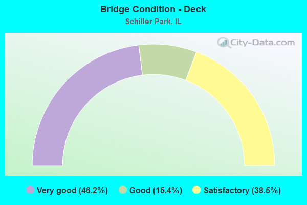
- Bridge Condition - Deck
- 46.2%Very good
- 15.4%Good
- 38.5%Satisfactory
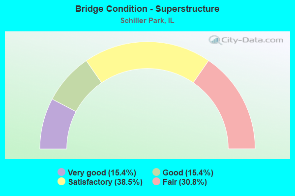
- Bridge Condition - Superstructure
- 15.4%Very good
- 15.4%Good
- 38.5%Satisfactory
- 30.8%Fair
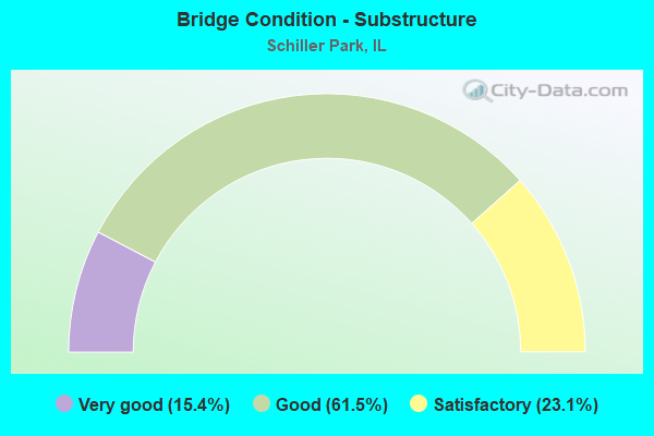
- Bridge Condition - Substructure
- 15.4%Very good
- 61.5%Good
- 23.1%Satisfactory
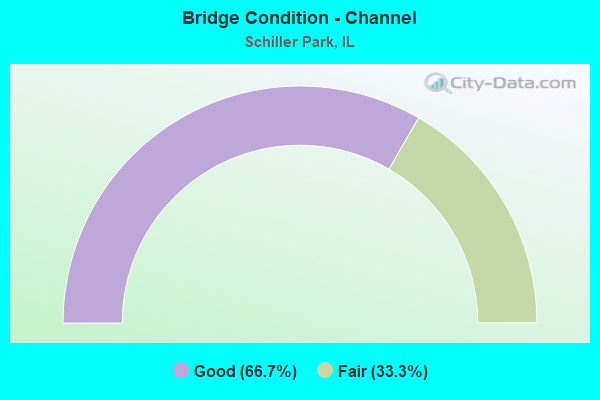
- Bridge Condition - Channel
- 66.7%Good
- 33.3%Fair
Find on map >> Show street view
Structure Number: 162603, Location: 1 M E I-294 (Lat: 41.966150, Lng: -87.855319), Route carried "on" structure: Other road , Year Built: 1994, Status: Open, Structure Length: 7.18m (23.56ft), Average Daily Traffic: 16,300 (year 2021), Truck Traffic: 1%, Average Future Daily Traffic: 19,879 (year 2032), Features Intersected: DES PLAINES RIVER, Facility Carried by Structure: LAWRENCE AVE
Minimum Vertical Clearance: 30+ m (98+ ft), Kilometerpoint: 1.770, Lanes on structure: 4, Base Highway Network: Yes, Owner: State Highway Agency, Approaching Roadway Width: 18.6m (61.0ft), Skew: 31 degrees, Material/Design: Steel continuous, Design/Construction: Stringer/Multi-beam, Number Of Spans In Main Unit: 3, Length of Maximum Span: 26.8m (87.9ft), Curb or Sidewalk Widths: Left: 1.5m (4.9ft), Right: 1.5m (4.9ft), Curb-To-Curb Width: 15.8m (51.8ft), Out-to-Out Width: 24.4m (80.1ft)
Condition: Deck: Good, Superstructure: Fair, Substructure: Good, Channel: Fair, Operating Rating: 63.2 metric tons, Method Used To Determine Operating Rating: Load Factor (LF) rating reported by rating factor (RF) method using MS18 loading, Inventory Rating: 37.9 metric tons, Method Used To Determine Inventory Rating: Load Factor (LF) rating reported by rating factor (RF) method using MS18 loading, Structural Evaluation: Somewhat better than minimum adequacy, Deck Geometry: Meets minimum limits, Waterway Adequacy: Equal to present desirable criteria, Approach Roadway Alignment: Equal to present desirable criteria, Designated Inspection Frequency: Every 24 months, Inspection Date: July 2021, Deck Structure Type: Concrete Cast-file-Place, Wearing Surface/Protective System: Deck Protection: Epoxy Coated Reinforcing
Find on map >> Show street view
Structure Number: 162672, Location: E. DES PLAINES RIV R (Lat: 41.953119, Lng: -87.854969), Route carried "on" structure: State highway 19, Year Built: 1996, Status: Open, Structure Length: 7.43m (24.38ft), Average Daily Traffic: 21,400 (year 2021), Truck Traffic: 3%, Average Future Daily Traffic: 23,587 (year 2032), Features Intersected: DES PLAINES RIVER
Minimum Vertical Clearance: 30+ m (98+ ft), Kilometerpoint: 36.789, Lanes on structure: 4, Base Highway Network: Yes, Owner: State Highway Agency, Approaching Roadway Width: 13.4m (44.0ft), Material/Design: Prestressed concrete continuous, Design/Construction: Stringer/Multi-beam, Number Of Spans In Main Unit: 3, Length of Maximum Span: 25.3m (83.0ft), Curb-To-Curb Width: 14.6m (47.9ft), Out-to-Out Width: 19.0m (62.3ft)
Condition: Deck: Satisfactory, Superstructure: Good, Substructure: Good, Channel: Good, Operating Rating: 65.8 metric tons, Method Used To Determine Operating Rating: Load Factor (LF) rating reported by rating factor (RF) method using MS18 loading, Inventory Rating: 39.5 metric tons, Method Used To Determine Inventory Rating: Load Factor (LF) rating reported by rating factor (RF) method using MS18 loading, Structural Evaluation: Better than present minimum criteria, Deck Geometry: High priority of replacement, Waterway Adequacy: Equal to present desirable criteria, Approach Roadway Alignment: Equal to present desirable criteria, Designated Inspection Frequency: Every 48 months, Inspection Date: April 2020, Deck Structure Type: Other, Wearing Surface/Protective System: Deck Protection: Epoxy Coated Reinforcing
Find on map >> Show street view
Structure Number: 162681, Location: 1 M S ILL 19 P9 (Lat: 41.947175, Lng: -87.884383), Route carried "on" structure: Interstate 294, Year Built: 1993, Status: Open, Structure Length: 95.74m (314.11ft), Average Daily Traffic: 73,100 (year 2020), Truck Traffic: 15%, Average Future Daily Traffic: 78,177 (year 2032), Design Load: HS 20, Features Intersected: US-45,RR YDS.& F.AVE
Minimum Vertical Clearance: 30+ m (98+ ft), Kilometerpoint: 24.848, Lanes on structure: 4, Lanes under structure: 4, Base Highway Network: Yes, Toll: On toll road, Owner: State Toll Authority, Approaching Roadway Width: 30.4m (99.7ft), Material/Design: Prestressed concrete continuous, Design/Construction: Stringer/Multi-beam, Number Of Spans In Main Unit: 28, Length of Maximum Span: 67.6m (221.8ft), Curb-To-Curb Width: 30.4m (99.7ft), Out-to-Out Width: 30.4m (99.7ft)
Condition: Deck: Satisfactory, Superstructure: Fair, Substructure: Good, Operating Rating: 48.3 metric tons, Method Used To Determine Operating Rating: Load Factor (LF) rating reported by rating factor (RF) method using MS18 loading, Inventory Rating: 28.8 metric tons, Method Used To Determine Inventory Rating: Load Factor (LF) rating reported by rating factor (RF) method using MS18 loading, Structural Evaluation: Somewhat better than minimum adequacy, Deck Geometry: Superior to present desirable criteria, Underclear: Somewhat better than minimum adequacy, Approach Roadway Alignment: Equal to present desirable criteria, Designated Inspection Frequency: Every 24 months, Inspection Date: June 2020, Deck Structure Type: Concrete Cast-file-Place, Wearing Surface/Protective System: Wearing Surface: Bituminous, Membrane: Built-up
Find on map >> Show street view
Structure Number: 162745, Location: 0.1 M S IL-19 (Lat: 41.955561, Lng: -87.880758), Route carried "on" structure: Interstate 294, Year Built: 1959, Year Reconstructed: 1991, Status: Open, Structure Length: 0.74m (2.43ft), Average Daily Traffic: 146,200 (year 2020), Truck Traffic: 15%, Average Future Daily Traffic: 156,354 (year 2032), Design Load: HS 20, Features Intersected: CRYSTAL CREEK
Minimum Vertical Clearance: 30+ m (98+ ft), Kilometerpoint: 23.705, Lanes on structure: 8, Base Highway Network: Yes, Toll: On toll road, Owner: State Toll Authority, Approaching Roadway Width: 46.3m (151.9ft), Skew: 1 degrees, Material/Design: Concrete continuous, Design/Construction: Culvert, Number Of Spans In Main Unit: 2, Length of Maximum Span: 3.0m (9.8ft)
Condition: Channel: Good, Culverts: Satisfactory, Operating Rating: 75.2 metric tons, Method Used To Determine Operating Rating: Load Factor (LF) rating reported by rating factor (RF) method using MS18 loading, Inventory Rating: 45.0 metric tons, Method Used To Determine Inventory Rating: Load Factor (LF) rating reported by rating factor (RF) method using MS18 loading, Structural Evaluation: Equal to present minimum criteria, Waterway Adequacy: Superior to present desirable criteria, Approach Roadway Alignment: Equal to present desirable criteria, Designated Inspection Frequency: Every 24 months, Inspection Date: April 2021
Find on map >> Show street view
Structure Number: 166341, Location: 294SB TO IL19EB (Lat: 41.957511, Lng: -87.879800), Route carried "on" structure: Other road , Year Built: 2006, Status: Open, Structure Length: 2.58m (8.46ft), Average Daily Traffic: 2,750 (year 2020), Average Future Daily Traffic: 5,768 (year 2032), Design Load: HS 20, Features Intersected: IL19, Facility Carried by Structure: I294 RAMP
Minimum Vertical Clearance: 30+ m (98+ ft), Kilometerpoint: 0.064, Lanes on structure: 1, Lanes under structure: 4, Base Highway Network: Yes (Inventory Route: 10294041, Subroute: 10), Toll: On toll road, Owner: State Toll Authority, Approaching Roadway Width: 10.7m (35.1ft), Skew: 1 degrees, Material/Design: Prestressed concrete, Design/Construction: Stringer/Multi-beam, Number Of Spans In Main Unit: 1, Length of Maximum Span: 24.8m (81.4ft), Curb-To-Curb Width: 9.8m (32.2ft), Out-to-Out Width: 10.7m (35.1ft)
Condition: Deck: Good, Superstructure: Good, Substructure: Good, Operating Rating: 70.0 metric tons, Method Used To Determine Operating Rating: Load Factor (LF) rating reported by rating factor (RF) method using MS18 loading, Inventory Rating: 41.8 metric tons, Method Used To Determine Inventory Rating: Load Factor (LF) rating reported by rating factor (RF) method using MS18 loading, Structural Evaluation: Better than present minimum criteria, Deck Geometry: Meets minimum limits, Approach Roadway Alignment: Equal to present desirable criteria, Designated Inspection Frequency: Every 24 months, Inspection Date: June 2020, Deck Structure Type: Concrete Cast-file-Place, Wearing Surface/Protective System: Wearing Surface: Latex Concrete, Deck Protection: Epoxy Coated Reinforcing
Find on map >> Show street view
Structure Number: 167942, Location: 0.6 MILE S OF I-190 (Lat: 41.969181, Lng: -87.876719), Route carried "on" structure: US 12, Year Built: 2015, Status: Open, Structure Length: 3.82m (12.53ft), Average Daily Traffic: 23,500 (year 2021), Truck Traffic: 18%, Average Future Daily Traffic: 26,000 (year 2032), Design Load: HS 25 or greater, Features Intersected: RAMP to BALMORAL
Minimum Vertical Clearance: 30+ m (98+ ft), Kilometerpoint: 78.019, Lanes on structure: 3, Lanes under structure: 1, Base Highway Network: Yes, Owner: State Highway Agency, Approaching Roadway Width: 17.1m (56.1ft), Skew: 3 degrees, Material/Design: Steel, Design/Construction: Stringer/Multi-beam, Number Of Spans In Main Unit: 1, Length of Maximum Span: 34.7m (113.8ft), Curb-To-Curb Width: 16.9m (55.4ft), Out-to-Out Width: 17.8m (58.4ft)
Condition: Deck: Very good, Superstructure: Very good, Substructure: Very good, Operating Rating: 57.7 metric tons, Method Used To Determine Operating Rating: Load and Resistance Factor Rating (LRFR) rating reported by rating factor(RF) method using HL-93 loadings, Inventory Rating: 44.4 metric tons, Method Used To Determine Inventory Rating: Load and Resistance Factor Rating (LRFR) rating reported by rating factor(RF) method using HL-93 loadings, Structural Evaluation: Equal to present desirable criteria, Deck Geometry: Superior to present desirable criteria, Approach Roadway Alignment: Equal to present desirable criteria, Designated Inspection Frequency: Every 24 months, Inspection Date: September 2021, Deck Structure Type: Concrete Cast-file-Place, Wearing Surface/Protective System: Deck Protection: Epoxy Coated Reinforcing
Find on map >> Show street view
Structure Number: 167943, Location: 0.6 MILES OF I-190 (Lat: 41.969181, Lng: -87.876719), Route carried "on" structure: US 12, Year Built: 2013, Status: Open, Structure Length: 3.82m (12.53ft), Average Daily Traffic: 23,500 (year 2021), Truck Traffic: 18%, Average Future Daily Traffic: 26,000 (year 2032), Design Load: HS 25 or greater, Features Intersected: RAMP to BALMORAL
Minimum Vertical Clearance: 30+ m (98+ ft), Kilometerpoint: 78.019, Lanes on structure: 2, Lanes under structure: 1, Base Highway Network: Yes, Owner: State Highway Agency, Approaching Roadway Width: 24.5m (80.4ft), Skew: 3 degrees, Material/Design: Steel, Design/Construction: Stringer/Multi-beam, Number Of Spans In Main Unit: 1, Length of Maximum Span: 35.7m (117.1ft), Curb-To-Curb Width: 24.5m (80.4ft), Out-to-Out Width: 25.4m (83.3ft)
Condition: Deck: Very good, Superstructure: Very good, Substructure: Very good, Operating Rating: 56.4 metric tons, Method Used To Determine Operating Rating: Load and Resistance Factor Rating (LRFR) rating reported by rating factor(RF) method using HL-93 loadings, Inventory Rating: 43.7 metric tons, Method Used To Determine Inventory Rating: Load and Resistance Factor Rating (LRFR) rating reported by rating factor(RF) method using HL-93 loadings, Structural Evaluation: Equal to present desirable criteria, Deck Geometry: Superior to present desirable criteria, Approach Roadway Alignment: Equal to present desirable criteria, Designated Inspection Frequency: Every 24 months, Inspection Date: September 2021, Deck Structure Type: Concrete Cast-file-Place, Wearing Surface/Protective System: Deck Protection: Epoxy Coated Reinforcing
Find on map >> Show street view
Structure Number: 169778, Location: 1 M N ILL 19 P9 (Lat: 41.970303, Lng: -87.871094), Route carried "on" structure: Interstate 294, Year Built: 1958, Status: Open, Structure Length: 14.14m (46.39ft), Average Daily Traffic: 81,750 (year 2021), Truck Traffic: 15%, Average Future Daily Traffic: 87,911 (year 2032), Features Intersected: W.C.RR
Minimum Vertical Clearance: 30+ m (98+ ft), Kilometerpoint: 21.935, Lanes on structure: 3, Base Highway Network: Yes, Toll: On toll road, Owner: State Toll Authority, Approaching Roadway Width: 15.8m (51.8ft), Skew: 4 degrees, Material/Design: Steel, Design/Construction: Stringer/Multi-beam, Number Of Spans In Main Unit: 5, Length of Maximum Span: 37.5m (123.0ft), Curb-To-Curb Width: 14.2m (46.6ft), Out-to-Out Width: 15.2m (49.9ft)
Condition: Deck: Satisfactory, Superstructure: Satisfactory, Substructure: Good, Operating Rating: 74.8 metric tons, Method Used To Determine Operating Rating: Load Factor (LF) rating reported by rating factor (RF) method using MS18 loading, Inventory Rating: 44.7 metric tons, Method Used To Determine Inventory Rating: Load Factor (LF) rating reported by rating factor (RF) method using MS18 loading, Structural Evaluation: Equal to present minimum criteria, Deck Geometry: Meets minimum limits, Underclear: Better than present minimum criteria, Approach Roadway Alignment: Equal to present desirable criteria, Designated Inspection Frequency: Every 24 months, Inspection Date: June 2020, Deck Structure Type: Concrete Cast-file-Place, Wearing Surface/Protective System: Wearing Surface: Bituminous, Membrane: Built-up
Find on map >> Show street view
Structure Number: 169779, Location: 1 M N ILL 19 P9 (Lat: 41.970167, Lng: -87.871181), Route carried "on" structure: Interstate 294, Year Built: 1958, Status: Open, Structure Length: 14.14m (46.39ft), Average Daily Traffic: 81,750 (year 2021), Truck Traffic: 15%, Average Future Daily Traffic: 87,911 (year 2032), Features Intersected: W.C.RR
Minimum Vertical Clearance: 30+ m (98+ ft), Kilometerpoint: 21.951, Lanes on structure: 3, Base Highway Network: Yes, Toll: On toll road, Owner: State Toll Authority, Approaching Roadway Width: 15.8m (51.8ft), Skew: 4 degrees, Material/Design: Steel, Design/Construction: Stringer/Multi-beam, Number Of Spans In Main Unit: 5, Length of Maximum Span: 37.5m (123.0ft), Curb-To-Curb Width: 14.2m (46.6ft), Out-to-Out Width: 15.2m (49.9ft)
Condition: Deck: Satisfactory, Superstructure: Satisfactory, Substructure: Good, Operating Rating: 82.3 metric tons, Method Used To Determine Operating Rating: Load Factor (LF) rating reported by rating factor (RF) method using MS18 loading, Inventory Rating: 45.0 metric tons, Method Used To Determine Inventory Rating: Load Factor (LF) rating reported by rating factor (RF) method using MS18 loading, Structural Evaluation: Equal to present minimum criteria, Deck Geometry: Meets minimum limits, Underclear: Better than present minimum criteria, Approach Roadway Alignment: Equal to present desirable criteria, Designated Inspection Frequency: Every 24 months, Inspection Date: June 2020, Deck Structure Type: Concrete Cast-file-Place, Wearing Surface/Protective System: Wearing Surface: Bituminous, Membrane: Built-up
Find on map >> Show street view
Structure Number: 16978, Location: 0.7M N ILL 19 P9 (Lat: 41.965631, Lng: -87.874178), Route carried "on" structure: Interstate 294, Year Built: 1958, Status: Open, Structure Length: 2.13m (6.99ft), Average Daily Traffic: 81,750 (year 2021), Truck Traffic: 15%, Average Future Daily Traffic: 87,911 (year 2032), Features Intersected: LAWRENCE AVE
Minimum Vertical Clearance: 30+ m (98+ ft), Kilometerpoint: 22.498, Lanes on structure: 3, Lanes under structure: 2, Base Highway Network: Yes, Toll: On toll road, Owner: State Toll Authority, Approaching Roadway Width: 15.8m (51.8ft), Skew: 2 degrees, Material/Design: Prestressed concrete, Design/Construction: Stringer/Multi-beam, Number Of Spans In Main Unit: 1, Length of Maximum Span: 20.4m (66.9ft), Curb-To-Curb Width: 14.2m (46.6ft), Out-to-Out Width: 18.6m (61.0ft)
Condition: Deck: Very good, Superstructure: Fair, Substructure: Satisfactory, Operating Rating: 60.9 metric tons, Method Used To Determine Operating Rating: Load Factor (LF) rating reported by rating factor (RF) method using MS18 loading, Inventory Rating: 36.6 metric tons, Method Used To Determine Inventory Rating: Load Factor (LF) rating reported by rating factor (RF) method using MS18 loading, Structural Evaluation: Somewhat better than minimum adequacy, Deck Geometry: Meets minimum limits, Underclear: Somewhat better than minimum adequacy, Approach Roadway Alignment: Equal to present desirable criteria, Designated Inspection Frequency: Every 24 months, Inspection Date: June 2020, Deck Structure Type: Concrete Cast-file-Place, Wearing Surface/Protective System: Wearing Surface: Bituminous, Membrane: Built-up
Find on map >> Show street view
Structure Number: 169781, Location: 0.7M N ILL 19 P9 (Lat: 41.965494, Lng: -87.874269), Route carried "on" structure: Interstate 294, Year Built: 1958, Status: Open, Structure Length: 2.13m (6.99ft), Average Daily Traffic: 81,750 (year 2021), Truck Traffic: 15%, Average Future Daily Traffic: 87,911 (year 2032), Features Intersected: LAWRENCE AVE
Minimum Vertical Clearance: 30+ m (98+ ft), Kilometerpoint: 22.514, Lanes on structure: 3, Lanes under structure: 2, Base Highway Network: Yes, Toll: On toll road, Owner: State Toll Authority, Approaching Roadway Width: 15.8m (51.8ft), Skew: 2 degrees, Material/Design: Prestressed concrete, Design/Construction: Stringer/Multi-beam, Number Of Spans In Main Unit: 1, Length of Maximum Span: 20.4m (66.9ft), Curb-To-Curb Width: 14.2m (46.6ft), Out-to-Out Width: 25.6m (84.0ft)
Condition: Deck: Very good, Superstructure: Satisfactory, Substructure: Satisfactory, Operating Rating: 56.7 metric tons, Method Used To Determine Operating Rating: Load Factor (LF) rating reported by rating factor (RF) method using MS18 loading, Inventory Rating: 34.0 metric tons, Method Used To Determine Inventory Rating: Load Factor (LF) rating reported by rating factor (RF) method using MS18 loading, Structural Evaluation: Equal to present minimum criteria, Deck Geometry: Meets minimum limits, Underclear: Somewhat better than minimum adequacy, Approach Roadway Alignment: Equal to present desirable criteria, Designated Inspection Frequency: Every 24 months, Inspection Date: June 2020, Deck Structure Type: Concrete Cast-file-Place, Wearing Surface/Protective System: Wearing Surface: Bituminous, Membrane: Built-up
Find on map >> Show street view
Structure Number: 169782, Location: I294 AT ILL 19 P9 (Lat: 41.956817, Lng: -87.879944), Route carried "on" structure: Interstate 294, Year Built: 1958, Year Reconstructed: 1970, Status: Open, Structure Length: 2.56m (8.40ft), Average Daily Traffic: 81,750 (year 2021), Truck Traffic: 15%, Average Future Daily Traffic: 87,911 (year 2032), Features Intersected: ILL 19 (IRVING PK)
Minimum Vertical Clearance: 30+ m (98+ ft), Kilometerpoint: 23.512, Lanes on structure: 4, Lanes under structure: 5, Base Highway Network: Yes, Toll: On toll road, Owner: State Toll Authority, Approaching Roadway Width: 19.5m (64.0ft), Skew: 1 degrees, Material/Design: Prestressed concrete, Design/Construction: Stringer/Multi-beam, Number Of Spans In Main Unit: 1, Length of Maximum Span: 25.0m (82.0ft), Curb-To-Curb Width: 16.5m (54.1ft), Out-to-Out Width: 21.3m (69.9ft)
Condition: Deck: Very good, Superstructure: Satisfactory, Substructure: Good, Operating Rating: 73.9 metric tons, Method Used To Determine Operating Rating: Load Factor (LF) rating reported by rating factor (RF) method using MS18 loading, Inventory Rating: 34.7 metric tons, Method Used To Determine Inventory Rating: Load Factor (LF) rating reported by rating factor (RF) method using MS18 loading, Structural Evaluation: Equal to present minimum criteria, Deck Geometry: High priority of replacement, Underclear: Meets minimum limits, Approach Roadway Alignment: Equal to present desirable criteria, Length Of Structure Improvement: 3.32m (10.89ft), Designated Inspection Frequency: Every 24 months, Inspection Date: June 2020, Bridge Improvement Cost: $517,000, Roadway Improvement Cost: $52,000, Total Project Cost: $776,000, Deck Structure Type: Concrete Cast-file-Place, Wearing Surface/Protective System: Wearing Surface: Bituminous, Membrane: Built-up
Find on map >> Show street view
Structure Number: 169783, Location: I294 AT ILL 19 P9 (Lat: 41.956658, Lng: -87.880047), Route carried "on" structure: Interstate 294, Year Built: 1958, Year Reconstructed: 1970, Status: Open, Structure Length: 2.56m (8.40ft), Average Daily Traffic: 81,750 (year 2021), Truck Traffic: 15%, Average Future Daily Traffic: 87,911 (year 2032), Features Intersected: ILL 19 (IRVING PK)
Minimum Vertical Clearance: 30+ m (98+ ft), Kilometerpoint: 23.544, Lanes on structure: 4, Lanes under structure: 5, Base Highway Network: Yes, Toll: On toll road, Owner: State Toll Authority, Approaching Roadway Width: 19.5m (64.0ft), Skew: 1 degrees, Material/Design: Prestressed concrete, Design/Construction: Stringer/Multi-beam, Number Of Spans In Main Unit: 1, Length of Maximum Span: 25.0m (82.0ft), Curb-To-Curb Width: 16.5m (54.1ft), Out-to-Out Width: 21.3m (69.9ft)
Condition: Deck: Very good, Superstructure: Satisfactory, Substructure: Good, Operating Rating: 69.3 metric tons, Method Used To Determine Operating Rating: Load Factor (LF) rating reported by rating factor (RF) method using MS18 loading, Inventory Rating: 33.0 metric tons, Method Used To Determine Inventory Rating: Load Factor (LF) rating reported by rating factor (RF) method using MS18 loading, Structural Evaluation: Equal to present minimum criteria, Deck Geometry: High priority of replacement, Underclear: Meets minimum limits, Approach Roadway Alignment: Equal to present desirable criteria, Length Of Structure Improvement: 3.32m (10.89ft), Designated Inspection Frequency: Every 24 months, Inspection Date: June 2020, Bridge Improvement Cost: $517,000, Roadway Improvement Cost: $52,000, Total Project Cost: $776,000, Deck Structure Type: Concrete Cast-file-Place, Wearing Surface/Protective System: Wearing Surface: Bituminous, Membrane: Built-up
Find on map >> Show street view
Structure Number: 169785, Location: 1 M S ILL 19 P9 (Lat: 41.948111, Lng: -87.883939), Route carried "on" structure: Interstate 294, Year Built: 1958, Status: Open, Structure Length: 94.88m (311.29ft), Average Daily Traffic: 73,100 (year 2020), Truck Traffic: 15%, Average Future Daily Traffic: 78,177 (year 2032), Features Intersected: US-45,RR YDS.& F.AVE
Minimum Vertical Clearance: 30+ m (98+ ft), Kilometerpoint: 24.719, Lanes on structure: 6, Lanes under structure: 4, Base Highway Network: Yes, Toll: On toll road, Owner: State Toll Authority, Approaching Roadway Width: 15.8m (51.8ft), Skew: 34 degrees, Material/Design: Steel, Design/Construction: Stringer/Multi-beam, Number Of Spans In Main Unit: 30, Length of Maximum Span: 47.2m (154.9ft), Curb-To-Curb Width: 12.6m (41.3ft), Out-to-Out Width: 27.4m (89.9ft)
Condition: Deck: Satisfactory, Superstructure: Fair, Substructure: Satisfactory, Operating Rating: 66.4 metric tons, Method Used To Determine Operating Rating: Load Factor (LF) rating reported by rating factor (RF) method using MS18 loading, Inventory Rating: 39.5 metric tons, Method Used To Determine Inventory Rating: Load Factor (LF) rating reported by rating factor (RF) method using MS18 loading, Structural Evaluation: Somewhat better than minimum adequacy, Deck Geometry: High priority of replacement, Underclear: Somewhat better than minimum adequacy, Approach Roadway Alignment: Equal to present desirable criteria, Length Of Structure Improvement: 94.88m (311.29ft), Designated Inspection Frequency: Every 24 months, Inspection Date: June 2020, Bridge Improvement Cost: $24,655,000, Roadway Improvement Cost: $2,466,000, Total Project Cost: $36,983,000, Deck Structure Type: Concrete Cast-file-Place, Wearing Surface/Protective System: Wearing Surface: Bituminous, Membrane: Built-up
Find on map >> Show street view
Structure Number: 160326, Location: 0.6 M E I294 (Lat: 41.954836, Lng: -87.866172), Route carried "under" structure: State highway 19, Year Built: 1900, Structure Length: 0. m, Average Daily Traffic: 28,000 (year 2021), Truck Traffic: 7%, Features Intersected: ILL 19 (IRVING PK), Facility Carried by Structure: W.C.RR
Minimum Vertical Clearance: 4.27m (14.01ft), Kilometerpoint: 35.807, Lanes under structure: 4, Material/Design: Steel, Length of Maximum Span: 16.2m (53.1ft)
Find on map >> Show street view
Structure Number: 160584, Location: 0.2 M E I294 P9 (Lat: 41.965694, Lng: -87.870739), Route carried "under" structure: Other road , Year Built: 1900, Structure Length: 0. m, Average Daily Traffic: 23,100 (year 2018), Truck Traffic: 8%, Features Intersected: LAWRENCE AVE, Facility Carried by Structure: CMSTP&P RR
Minimum Vertical Clearance: 4.32m (14.17ft), Kilometerpoint: 0.483, Lanes under structure: 4, Material/Design: Steel, Length of Maximum Span: 15.2m (49.9ft)
Find on map >> Show street view
Structure Number: 160585, Location: 0.21 M E I294 P9 (Lat: 41.965706, Lng: -87.870153), Route carried "under" structure: Other road , Year Built: 1900, Structure Length: 0. m, Average Daily Traffic: 23,100 (year 2018), Truck Traffic: 8%, Features Intersected: LAWRENCE AVE, Facility Carried by Structure: W.C.RR
Minimum Vertical Clearance: 4.32m (14.17ft), Kilometerpoint: 0.531, Lanes under structure: 4, Material/Design: Steel, Length of Maximum Span: 15.2m (49.9ft)
Find on map >> Show street view
Structure Number: 166341, Location: 294SB TO IL19EB (Lat: 41.956694, Lng: -87.880328), Route carried "under" structure: State highway 19, Year Built: 2006, Structure Length: 0. m, Average Daily Traffic: 33,000 (year 2021), Truck Traffic: 10%, Features Intersected: IL19, Facility Carried by Structure: I294 RAMP
Minimum Vertical Clearance: 4.57m (14.99ft), Kilometerpoint: 34.600, Lanes on structure: 1, Lanes under structure: 4, Toll: On toll road, Material/Design: Prestressed concrete, Design/Construction: Stringer/Multi-beam, Length of Maximum Span: 24.8m (81.4ft)
Find on map >> Show street view
Structure Number: 167942, Location: 0.6 MILE S OF I-190 (Lat: 41.969397, Lng: -87.876778), Route carried "under" structure: Other road , Year Built: 2015, Structure Length: 0. m, Average Daily Traffic: 3,300 (year 2018), Truck Traffic: 5%, Features Intersected: RAMP to BALMORAL, Facility Carried by Structure: US 12,45 SB MANNHE
Minimum Vertical Clearance: 4.55m (14.93ft), Kilometerpoint: 0.322, Lanes on structure: 3, Lanes under structure: 1, Material/Design: Steel, Design/Construction: Stringer/Multi-beam, Length of Maximum Span: 34.7m (113.8ft)
Find on map >> Show street view
Structure Number: 167943, Location: 0.6 MILES OF I-190 (Lat: 41.969397, Lng: -87.876778), Route carried "under" structure: Other road , Year Built: 2013, Structure Length: 0. m, Average Daily Traffic: 3,300 (year 2018), Truck Traffic: 5%, Features Intersected: RAMP to BALMORAL, Facility Carried by Structure: US 12,45 NB MANNHE
Minimum Vertical Clearance: 4.42m (14.50ft), Kilometerpoint: 0.322, Lanes on structure: 2, Lanes under structure: 1, Material/Design: Steel, Design/Construction: Stringer/Multi-beam, Length of Maximum Span: 35.7m (117.1ft)
Find on map >> Show street view
Structure Number: 16978, Location: 0.7M N ILL 19 P9 (Lat: 41.965631, Lng: -87.874178), Route carried "under" structure: Other road , Year Built: 1958, Structure Length: 0. m, Average Daily Traffic: 23,100 (year 2018), Truck Traffic: 8%, Features Intersected: LAWRENCE AVE, Facility Carried by Structure: I-294 NB
Minimum Vertical Clearance: 4.34m (14.24ft), Kilometerpoint: 0.225, Lanes on structure: 3, Lanes under structure: 2, Toll: On toll road, Material/Design: Prestressed concrete, Design/Construction: Stringer/Multi-beam, Length of Maximum Span: 20.4m (66.9ft)
Find on map >> Show street view
Structure Number: 169781, Location: 0.7M N ILL 19 P9 (Lat: 41.965628, Lng: -87.874339), Route carried "under" structure: Other road , Year Built: 1958, Structure Length: 0. m, Average Daily Traffic: 21,200 (year 2018), Truck Traffic: 9%, Features Intersected: LAWRENCE AVE, Facility Carried by Structure: I-294 SB
Minimum Vertical Clearance: 4.47m (14.67ft), Kilometerpoint: 0.209, Lanes on structure: 3, Lanes under structure: 2, Toll: On toll road, Material/Design: Prestressed concrete, Design/Construction: Stringer/Multi-beam, Length of Maximum Span: 20.4m (66.9ft)
Find on map >> Show street view
Structure Number: 169782, Location: I294 AT ILL 19 P9 (Lat: 41.956658, Lng: -87.880047), Route carried "under" structure: State highway 19, Year Built: 1958, Structure Length: 0. m, Average Daily Traffic: 33,000 (year 2021), Truck Traffic: 10%, Features Intersected: ILL 19 (IRVING PK), Facility Carried by Structure: I-294 NB
Minimum Vertical Clearance: 4.39m (14.40ft), Kilometerpoint: 34.648, Lanes on structure: 4, Lanes under structure: 5, Toll: On toll road, Material/Design: Prestressed concrete, Design/Construction: Stringer/Multi-beam, Length of Maximum Span: 25.0m (82.0ft)
Find on map >> Show street view
Structure Number: 169783, Location: I294 AT ILL 19 P9 (Lat: 41.956678, Lng: -87.880203), Route carried "under" structure: State highway 19, Year Built: 1958, Structure Length: 0. m, Average Daily Traffic: 33,000 (year 2021), Truck Traffic: 10%, Features Intersected: ILL 19 (IRVING PK), Facility Carried by Structure: I-294 SB
Minimum Vertical Clearance: 4.39m (14.40ft), Kilometerpoint: 34.632, Lanes on structure: 4, Lanes under structure: 5, Toll: On toll road, Material/Design: Prestressed concrete, Design/Construction: Stringer/Multi-beam, Length of Maximum Span: 25.0m (82.0ft)