Bridge Statistics for Savage-Guilford, Maryland (MD)
Condition, Traffic, Stress, Structural Evaluation, Project Costs
- National Bridge Inventory (NBI) Statistics
- 29Number of bridges
- 407ft / 124mTotal length
- $1,872,000Total costs
- 2,432,625Total average daily traffic
- 132,054Total average daily truck traffic
- National Bridge Inventory (NBI) Registered Bridges for Savage-Guilford
- No street view available for this location
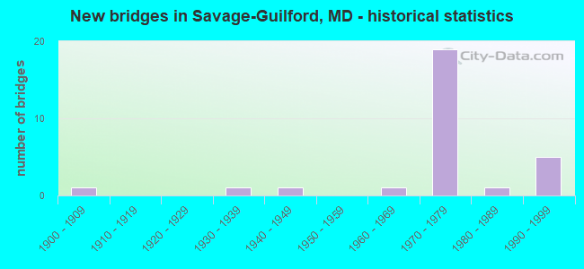
- New bridges - historical statistics
- 11900-1909
- 11930-1939
- 11940-1949
- 11960-1969
- 191970-1979
- 11980-1989
- 51990-1999

- Reconstructed bridges - Historical Statistics
- 11920-1929
- 01930-1939
- 01940-1949
- 01950-1959
- 21960-1969
- 11970-1979
- 11980-1989
- 11990-1999


- Bridge Condition - Deck
- 29.4%Good
- 17.6%Satisfactory
- 52.9%Fair

- Bridge Condition - Superstructure
- 5.9%Very good
- 11.8%Good
- 58.8%Satisfactory
- 23.5%Fair

- Bridge Condition - Substructure
- 29.4%Good
- 47.1%Satisfactory
- 23.5%Fair

- Bridge Condition - Channel
- 40.0%Very good
- 10.0%Good
- 50.0%Satisfactory

- Bridge Condition - Culverts
- 33.3%Good
- 66.7%Satisfactory
Find on map >> Show street view
Structure Number: 10000013000602, Location: 0.26 M S OF GUILFORD ROAD (Lat: 39.141078, Lng: -76.811642), Route carried "on" structure: US 1, Year Built: 1983, Status: Open, Structure Length: 1.05m (3.44ft), Average Daily Traffic: 38,190 (year 2013), Truck Traffic: 8%, Average Future Daily Traffic: 44,763 (year 2026), Design Load: HS 20, Features Intersected: GUILFORD BRANCH
Minimum Vertical Clearance: 30+ m (98+ ft), Kilometerpoint: 4.827, Lanes on structure: 5, Base Highway Network: Yes, Owner: State Highway Agency, Approaching Roadway Width: 32.0m (105.0ft), Skew: 22 degrees, Material/Design: Concrete, Design/Construction: Culvert, Length of Maximum Span: 3.4m (11.2ft)
Condition: Channel: Satisfactory, Culverts: Satisfactory, Operating Rating: 32.7 metric tons, Method Used To Determine Operating Rating: Field evaluation and documented engineering judgment, Inventory Rating: 32.7 metric tons, Method Used To Determine Inventory Rating: Field evaluation and documented engineering judgment, Structural Evaluation: Equal to present minimum criteria, Waterway Adequacy: Equal to present desirable criteria, Approach Roadway Alignment: Equal to present desirable criteria, Designated Inspection Frequency: Every 24 months, Inspection Date: June 2020
Find on map >> Show street view
Structure Number: 100000130007012, Location: 0.38 MILE SOUTH OF MD 32 (Lat: 39.134503, Lng: -76.816325), Route carried "on" structure: US 1, Year Built: 1900, Year Reconstructed: 1929, Status: Open, Structure Length: 2.97m (9.74ft), Average Daily Traffic: 20,330 (year 2013), Truck Traffic: 8%, Average Future Daily Traffic: 24,697 (year 2032), Features Intersected: LITTLE PATUXENT RIVER
Minimum Vertical Clearance: 30+ m (98+ ft), Kilometerpoint: 3.928, Lanes on structure: 2, Base Highway Network: Yes, Owner: State Highway Agency, Approaching Roadway Width: 15.9m (52.2ft), Material/Design: Concrete, Design/Construction: Arch - Deck, Number Of Spans In Main Unit: 1, Length of Maximum Span: 29.6m (97.1ft), Curb-To-Curb Width: 12.2m (40.0ft), Out-to-Out Width: 13.3m (43.6ft)
Condition: Deck: Fair, Superstructure: Fair, Substructure: Satisfactory, Channel: Satisfactory, Structural Evaluation: Somewhat better than minimum adequacy, Deck Geometry: Better than present minimum criteria, Waterway Adequacy: Superior to present desirable criteria, Approach Roadway Alignment: Equal to present desirable criteria, Length Of Structure Improvement: 3.02m (9.91ft), Designated Inspection Frequency: Every 24 months, Inspection Date: July 2020, Bridge Improvement Cost: $258,000, Roadway Improvement Cost: $26,000, Total Project Cost: $284,000, Deck Structure Type: Concrete Cast-file-Place, Wearing Surface/Protective System: Wearing Surface: Bituminous
Find on map >> Show street view
Structure Number: 100000130056011, Location: 0.18 MILE NORTH OF IS 95I (Lat: 39.147083, Lng: -76.842139), Route carried "on" structure: Interstate 95, Year Built: 1970, Status: Open, Structure Length: 7.74m (25.39ft), Average Daily Traffic: 186,750 (year 2009), Truck Traffic: 8%, Average Future Daily Traffic: 302,430 (year 2029), Design Load: HS 20, Features Intersected: MIDDLE PATUXENT RIVER
Minimum Vertical Clearance: 30+ m (98+ ft), Kilometerpoint: 4.558, Lanes on structure: 4, Base Highway Network: Yes, Owner: State Highway Agency, Approaching Roadway Width: 20.7m (67.9ft), Material/Design: Steel continuous, Design/Construction: Stringer/Multi-beam, Number Of Spans In Main Unit: 3, Length of Maximum Span: 29.0m (95.1ft), Curb-To-Curb Width: 20.7m (67.9ft), Out-to-Out Width: 21.6m (70.9ft)
Condition: Deck: Satisfactory, Superstructure: Satisfactory, Substructure: Satisfactory, Channel: Very good, Operating Rating: 78.0 metric tons, Method Used To Determine Operating Rating: Load Factor (LF), Inventory Rating: 46.7 metric tons, Method Used To Determine Inventory Rating: Load Factor (LF), Structural Evaluation: Equal to present minimum criteria, Deck Geometry: Equal to present minimum criteria, Waterway Adequacy: Superior to present desirable criteria, Approach Roadway Alignment: Equal to present desirable criteria, Designated Inspection Frequency: Every 24 months, Inspection Date: July 2020, Deck Structure Type: Concrete Cast-file-Place, Wearing Surface/Protective System: Wearing Surface: Monolithic Concrete
Find on map >> Show street view
Structure Number: 100000130056012, Location: 0.18 MILE NORTH OF IS 95I (Lat: 39.147931, Lng: -76.842278), Route carried "on" structure: Interstate 95, Year Built: 1970, Status: Open, Structure Length: 7.74m (25.39ft), Average Daily Traffic: 186,750 (year 2009), Truck Traffic: 8%, Average Future Daily Traffic: 302,430 (year 2029), Design Load: HS 20, Features Intersected: MIDDLE PATUXENT RIVER
Minimum Vertical Clearance: 30+ m (98+ ft), Kilometerpoint: 4.558, Lanes on structure: 4, Base Highway Network: Yes, Owner: State Highway Agency, Approaching Roadway Width: 20.7m (67.9ft), Material/Design: Steel continuous, Design/Construction: Stringer/Multi-beam, Number Of Spans In Main Unit: 3, Length of Maximum Span: 29.0m (95.1ft), Curb-To-Curb Width: 20.7m (67.9ft), Out-to-Out Width: 21.6m (70.9ft)
Condition: Deck: Satisfactory, Superstructure: Satisfactory, Substructure: Satisfactory, Channel: Very good, Operating Rating: 81.6 metric tons, Method Used To Determine Operating Rating: Load Factor (LF), Inventory Rating: 49.0 metric tons, Method Used To Determine Inventory Rating: Load Factor (LF), Structural Evaluation: Equal to present minimum criteria, Deck Geometry: Equal to present minimum criteria, Waterway Adequacy: Superior to present desirable criteria, Approach Roadway Alignment: Equal to present desirable criteria, Designated Inspection Frequency: Every 24 months, Inspection Date: July 2020, Deck Structure Type: Concrete Cast-file-Place, Wearing Surface/Protective System: Wearing Surface: Monolithic Concrete
Find on map >> Show street view
Structure Number: 100000130064011, Location: 0.75 M N OF GUILFORD ROAD (Lat: 39.164858, Lng: -76.811497), Route carried "on" structure: Interstate 95, Year Built: 1970, Status: Open, Structure Length: 3.90m (12.80ft), Average Daily Traffic: 187,920 (year 2009), Truck Traffic: 8%, Average Future Daily Traffic: 292,820 (year 2029), Design Load: HS 20, Features Intersected: CSX TRANSPORTATION
Minimum Vertical Clearance: 30+ m (98+ ft), Kilometerpoint: 7.987, Lanes on structure: 4, Base Highway Network: Yes, Owner: State Highway Agency, Approaching Roadway Width: 20.7m (67.9ft), Material/Design: Concrete continuous, Design/Construction: Slab, Number Of Spans In Main Unit: 3, Length of Maximum Span: 16.5m (54.1ft), Curb-To-Curb Width: 20.7m (67.9ft), Out-to-Out Width: 21.6m (70.9ft)
Condition: Deck: Fair, Superstructure: Fair, Substructure: Fair, Operating Rating: 66.7 metric tons, Method Used To Determine Operating Rating: Load Factor (LF), Inventory Rating: 39.9 metric tons, Method Used To Determine Inventory Rating: Load Factor (LF), Structural Evaluation: Somewhat better than minimum adequacy, Deck Geometry: Equal to present minimum criteria, Underclear: Better than present minimum criteria, Approach Roadway Alignment: Equal to present desirable criteria, Designated Inspection Frequency: Every 24 months, Inspection Date: May 2021, Deck Structure Type: Concrete Cast-file-Place, Wearing Surface/Protective System: Wearing Surface: Latex Concrete, Deck Protection: Cathodic Protection
Find on map >> Show street view
Structure Number: 100000130064012, Location: 0.75 M N OF GUILFORD ROAD (Lat: 39.165503, Lng: -76.811556), Route carried "on" structure: Interstate 95, Year Built: 1970, Status: Open, Structure Length: 3.90m (12.80ft), Average Daily Traffic: 187,920 (year 2009), Truck Traffic: 8%, Average Future Daily Traffic: 292,820 (year 2029), Design Load: HS 20, Features Intersected: CSX TRANSPORTATION
Minimum Vertical Clearance: 30+ m (98+ ft), Kilometerpoint: 7.987, Lanes on structure: 4, Base Highway Network: Yes, Owner: State Highway Agency, Approaching Roadway Width: 20.7m (67.9ft), Material/Design: Concrete continuous, Design/Construction: Slab, Number Of Spans In Main Unit: 3, Length of Maximum Span: 16.5m (54.1ft), Curb-To-Curb Width: 20.7m (67.9ft), Out-to-Out Width: 21.6m (70.9ft)
Condition: Deck: Fair, Superstructure: Fair, Substructure: Fair, Operating Rating: 66.7 metric tons, Method Used To Determine Operating Rating: Load Factor (LF), Inventory Rating: 39.9 metric tons, Method Used To Determine Inventory Rating: Load Factor (LF), Structural Evaluation: Somewhat better than minimum adequacy, Deck Geometry: Equal to present minimum criteria, Underclear: Better than present minimum criteria, Approach Roadway Alignment: Equal to present desirable criteria, Designated Inspection Frequency: Every 24 months, Inspection Date: May 2021, Deck Structure Type: Concrete Cast-file-Place, Wearing Surface/Protective System: Wearing Surface: Latex Concrete, Deck Protection: Cathodic Protection
Find on map >> Show street view
Structure Number: 10000013006501, Location: 0.06 MILE SOUTH OF IS 95 (Lat: 39.157406, Lng: -76.822139), Route carried "on" structure: Ramp Interstate 32, Year Built: 1970, Status: Open, Structure Length: 5.67m (18.60ft), Average Daily Traffic: 8,048 (year 2006), Truck Traffic: 8%, Average Future Daily Traffic: 8,692 (year 2026), Design Load: HS 20, Features Intersected: GUILDFORD ROAD
Minimum Vertical Clearance: 30+ m (98+ ft), Kilometerpoint: 4.859, Lanes on structure: 1, Lanes under structure: 2, Base Highway Network: Yes, Owner: State Highway Agency, Approaching Roadway Width: 8.8m (28.9ft), Skew: 4 degrees, Material/Design: Steel continuous, Design/Construction: Stringer/Multi-beam, Number Of Spans In Main Unit: 3, Length of Maximum Span: 24.4m (80.1ft), Curb-To-Curb Width: 9.3m (30.5ft), Out-to-Out Width: 10.2m (33.5ft)
Condition: Deck: Fair, Superstructure: Satisfactory, Substructure: Satisfactory, Operating Rating: 63.9 metric tons, Method Used To Determine Operating Rating: Load Factor (LF), Inventory Rating: 38.1 metric tons, Method Used To Determine Inventory Rating: Load Factor (LF), Structural Evaluation: Equal to present minimum criteria, Deck Geometry: Superior to present desirable criteria, Underclear: Equal to present minimum criteria, Approach Roadway Alignment: Equal to present desirable criteria, Designated Inspection Frequency: Every 24 months, Inspection Date: May 2021, Deck Structure Type: Concrete Cast-file-Place, Wearing Surface/Protective System: Wearing Surface: Latex Concrete
Find on map >> Show street view
Structure Number: 10000013006601, Location: 1.55 MILES N OF IS 95I (Lat: 39.158508, Lng: -76.822892), Route carried "on" structure: Interstate 95, Year Built: 1970, Status: Open, Structure Length: 4.42m (14.50ft), Average Daily Traffic: 187,920 (year 2009), Truck Traffic: 8%, Average Future Daily Traffic: 94,770 (year 2026), Design Load: HS 20, Features Intersected: GUILFORD ROAD
Minimum Vertical Clearance: 30+ m (98+ ft), Kilometerpoint: 6.790, Lanes on structure: 5, Lanes under structure: 2, Base Highway Network: Yes, Owner: State Highway Agency, Approaching Roadway Width: 24.4m (80.1ft), Material/Design: Steel continuous, Design/Construction: Stringer/Multi-beam, Number Of Spans In Main Unit: 3, Length of Maximum Span: 18.0m (59.1ft), Curb-To-Curb Width: 24.4m (80.1ft), Out-to-Out Width: 25.3m (83.0ft)
Condition: Deck: Satisfactory, Superstructure: Satisfactory, Substructure: Satisfactory, Operating Rating: 84.8 metric tons, Method Used To Determine Operating Rating: Load Factor (LF), Inventory Rating: 50.8 metric tons, Method Used To Determine Inventory Rating: Load Factor (LF), Structural Evaluation: Equal to present minimum criteria, Deck Geometry: Equal to present minimum criteria, Underclear: Meets minimum limits, Approach Roadway Alignment: Equal to present desirable criteria, Length Of Structure Improvement: 4.42m (14.50ft), Designated Inspection Frequency: Every 24 months, Inspection Date: May 2021, Bridge Improvement Cost: $1,444,000, Roadway Improvement Cost: $144,000, Total Project Cost: $1,588,000, Deck Structure Type: Concrete Cast-file-Place, Wearing Surface/Protective System: Wearing Surface: Monolithic Concrete
Find on map >> Show street view
Structure Number: 10000013006701, Location: 1.74 MILES N OF US 1 (Lat: 39.159811, Lng: -76.823431), Route carried "on" structure: County highway 1910, Year Built: 1969, Status: Open, Structure Length: 7.59m (24.90ft), Average Daily Traffic: 15,711 (year 2009), Truck Traffic: 8%, Average Future Daily Traffic: 9,299 (year 2026), Design Load: HS 20, Features Intersected: IS 95 SBR, Facility Carried by Structure: GUILFORD ROAD
Minimum Vertical Clearance: 30+ m (98+ ft), Kilometerpoint: 4.988, Lanes on structure: 2, Lanes under structure: 5, Owner: State Highway Agency, Approaching Roadway Width: 13.4m (44.0ft), Skew: 1 degrees, Material/Design: Steel continuous, Design/Construction: Stringer/Multi-beam, Number Of Spans In Main Unit: 3, Length of Maximum Span: 32.3m (106.0ft), Curb-To-Curb Width: 13.4m (44.0ft), Out-to-Out Width: 14.3m (46.9ft)
Condition: Deck: Fair, Superstructure: Satisfactory, Substructure: Good, Operating Rating: 65.8 metric tons, Method Used To Determine Operating Rating: Load Factor (LF), Inventory Rating: 39.5 metric tons, Method Used To Determine Inventory Rating: Load Factor (LF), Structural Evaluation: Equal to present minimum criteria, Deck Geometry: Equal to present minimum criteria, Underclear: Meets minimum limits, Approach Roadway Alignment: Equal to present desirable criteria, Designated Inspection Frequency: Every 24 months, Inspection Date: October 2020, Deck Structure Type: Concrete Cast-file-Place, Wearing Surface/Protective System: Wearing Surface: Monolithic Concrete
Find on map >> Show street view
Structure Number: 10000013006801, Location: 0.14 M S OF GUILFORD ROAD (Lat: 39.157703, Lng: -76.825383), Route carried "on" structure: Interstate 95, Year Built: 1970, Status: Open, Structure Length: 8.63m (28.31ft), Average Daily Traffic: 187,920 (year 2009), Truck Traffic: 8%, Average Future Daily Traffic: 94,770 (year 2026), Design Load: HS 20, Features Intersected: MD 32 WBR
Minimum Vertical Clearance: 30+ m (98+ ft), Kilometerpoint: 6.565, Lanes on structure: 7, Lanes under structure: 5, Base Highway Network: Yes, Owner: State Highway Agency, Approaching Roadway Width: 32.9m (107.9ft), Skew: 1 degrees, Material/Design: Steel continuous, Design/Construction: Stringer/Multi-beam, Number Of Spans In Main Unit: 3, Length of Maximum Span: 36.0m (118.1ft), Curb-To-Curb Width: 32.9m (107.9ft), Out-to-Out Width: 37.8m (124.0ft)
Condition: Deck: Fair, Superstructure: Fair, Substructure: Fair, Operating Rating: 65.8 metric tons, Method Used To Determine Operating Rating: Load Factor (LF), Inventory Rating: 39.5 metric tons, Method Used To Determine Inventory Rating: Load Factor (LF), Structural Evaluation: Somewhat better than minimum adequacy, Deck Geometry: Better than present minimum criteria, Underclear: Somewhat better than minimum adequacy, Approach Roadway Alignment: Equal to present desirable criteria, Designated Inspection Frequency: Every 24 months, Inspection Date: Febuary 2020, Deck Structure Type: Concrete Cast-file-Place, Wearing Surface/Protective System: Wearing Surface: Monolithic Concrete
Find on map >> Show street view
Structure Number: 10000013006901, Location: 1.74 MILES NORTH OF US 1 (Lat: 39.159136, Lng: -76.826828), Route carried "on" structure: State highway 32, Year Built: 1970, Year Reconstructed: 1972, Status: Open, Structure Length: 9.08m (29.79ft), Average Daily Traffic: 91,311 (year 2009), Truck Traffic: 8%, Average Future Daily Traffic: 53,225 (year 2026), Design Load: HS 20, Features Intersected: IS 95 SBR
Minimum Vertical Clearance: 30+ m (98+ ft), Kilometerpoint: 5.165, Lanes on structure: 3, Lanes under structure: 4, Base Highway Network: Yes, Owner: State Highway Agency, Approaching Roadway Width: 18.9m (62.0ft), Skew: 3 degrees, Material/Design: Steel continuous, Design/Construction: Stringer/Multi-beam, Number Of Spans In Main Unit: 3, Length of Maximum Span: 41.1m (134.8ft), Curb-To-Curb Width: 17.7m (58.1ft), Out-to-Out Width: 18.7m (61.4ft)
Condition: Deck: Fair, Superstructure: Satisfactory, Substructure: Satisfactory, Operating Rating: 72.6 metric tons, Method Used To Determine Operating Rating: Load Factor (LF), Inventory Rating: 43.5 metric tons, Method Used To Determine Inventory Rating: Load Factor (LF), Structural Evaluation: Equal to present minimum criteria, Deck Geometry: Better than present minimum criteria, Underclear: Somewhat better than minimum adequacy, Approach Roadway Alignment: Equal to present desirable criteria, Designated Inspection Frequency: Every 24 months, Inspection Date: October 2020, Deck Structure Type: Concrete Cast-file-Place, Wearing Surface/Protective System: Wearing Surface: Monolithic Concrete
Find on map >> Show street view
Structure Number: 10000013007101, Location: 1.74 MILES NORTH OF US 1 (Lat: 39.158464, Lng: -76.828914), Route carried "on" structure: State highway 32, Year Built: 1970, Year Reconstructed: 1972, Status: Open, Structure Length: 9.97m (32.71ft), Average Daily Traffic: 15,262 (year 2018), Truck Traffic: 8%, Average Future Daily Traffic: 15,287 (year 2038), Design Load: HS 20, Features Intersected: IS 95 SBR
Minimum Vertical Clearance: 30+ m (98+ ft), Kilometerpoint: 5.213, Lanes on structure: 5, Lanes under structure: 6, Base Highway Network: Yes, Owner: State Highway Agency, Approaching Roadway Width: 25.3m (83.0ft), Skew: 2 degrees, Material/Design: Steel continuous, Design/Construction: Stringer/Multi-beam, Number Of Spans In Main Unit: 3, Length of Maximum Span: 45.1m (148.0ft), Curb-To-Curb Width: 26.3m (86.3ft), Out-to-Out Width: 26.9m (88.3ft)
Condition: Deck: Fair, Superstructure: Satisfactory, Substructure: Fair, Operating Rating: 68.0 metric tons, Method Used To Determine Operating Rating: Load Factor (LF), Inventory Rating: 40.8 metric tons, Method Used To Determine Inventory Rating: Load Factor (LF), Structural Evaluation: Somewhat better than minimum adequacy, Deck Geometry: Superior to present desirable criteria, Underclear: Somewhat better than minimum adequacy, Approach Roadway Alignment: Equal to present desirable criteria, Designated Inspection Frequency: Every 24 months, Inspection Date: March 2020, Deck Structure Type: Concrete Cast-file-Place, Wearing Surface/Protective System: Wearing Surface: Monolithic Concrete
Find on map >> Show street view
Structure Number: 100000130072011, Location: 0.46 MILE SOUTH OF MD 32 (Lat: 39.155247, Lng: -76.833794), Route carried "on" structure: Interstate 95, Year Built: 1971, Status: Open, Structure Length: 12.04m (39.50ft), Average Daily Traffic: 104,355 (year 2018), Truck Traffic: 8%, Average Future Daily Traffic: 169,000 (year 2038), Design Load: HS 20, Features Intersected: LITTLE PATUXENT RIVER
Minimum Vertical Clearance: 30+ m (98+ ft), Kilometerpoint: 5.762, Lanes on structure: 4, Base Highway Network: Yes, Owner: State Highway Agency, Approaching Roadway Width: 20.7m (67.9ft), Material/Design: Steel continuous, Design/Construction: Stringer/Multi-beam, Number Of Spans In Main Unit: 4, Length of Maximum Span: 32.0m (105.0ft), Curb-To-Curb Width: 21.0m (68.9ft), Out-to-Out Width: 21.6m (70.9ft)
Condition: Deck: Good, Superstructure: Satisfactory, Substructure: Satisfactory, Channel: Very good, Operating Rating: 78.0 metric tons, Method Used To Determine Operating Rating: Load Factor (LF), Inventory Rating: 46.7 metric tons, Method Used To Determine Inventory Rating: Load Factor (LF), Structural Evaluation: Equal to present minimum criteria, Deck Geometry: Better than present minimum criteria, Waterway Adequacy: Superior to present desirable criteria, Approach Roadway Alignment: Equal to present desirable criteria, Length Of Structure Improvement: 12.04m (39.50ft), Designated Inspection Frequency: Every 24 months, Inspection Date: April 2020, Deck Structure Type: Concrete Cast-file-Place, Wearing Surface/Protective System: Wearing Surface: Monolithic Concrete
Find on map >> Show street view
Structure Number: 10000013008001, Location: 0.9 MI W OF US 1 (Lat: 39.148486, Lng: -76.823481), Route carried "on" structure: County highway 194, Year Built: 1971, Status: Open, Structure Length: 11.89m (39.01ft), Average Daily Traffic: 2,667 (year 2006), Truck Traffic: 5%, Average Future Daily Traffic: 3,075 (year 2026), Design Load: HS 20, Features Intersected: MD 32, Facility Carried by Structure: VOLLMERHAUSEN ROAD
Minimum Vertical Clearance: 30+ m (98+ ft), Kilometerpoint: 3.250, Lanes on structure: 2, Lanes under structure: 2, Owner: State Highway Agency, Approaching Roadway Width: 11.0m (36.1ft), Skew: 1 degrees, Material/Design: Steel continuous, Design/Construction: Stringer/Multi-beam, Number Of Spans In Main Unit: 5, Length of Maximum Span: 27.7m (90.9ft), Curb or Sidewalk Widths: Left: 0.0m, Right: 1.5m (4.9ft), Curb-To-Curb Width: 11.0m (36.1ft), Out-to-Out Width: 13.7m (44.9ft)
Condition: Deck: Fair, Superstructure: Satisfactory, Substructure: Good, Operating Rating: 60.8 metric tons, Method Used To Determine Operating Rating: Load Factor (LF), Inventory Rating: 36.7 metric tons, Method Used To Determine Inventory Rating: Load Factor (LF), Structural Evaluation: Equal to present minimum criteria, Deck Geometry: Somewhat better than minimum adequacy, Underclear: Somewhat better than minimum adequacy, Approach Roadway Alignment: Equal to present desirable criteria, Designated Inspection Frequency: Every 24 months, Inspection Date: April 2021, Deck Structure Type: Concrete Cast-file-Place, Wearing Surface/Protective System: Wearing Surface: Monolithic Concrete
Find on map >> Show street view
Structure Number: 100000130114013, Location: 0.89 MILE NORTH OF US 29 (Lat: 39.183364, Lng: -76.890697), Route carried "on" structure: State highway 32, Year Built: 1995, Status: Open, Structure Length: 14.30m (46.92ft), Average Daily Traffic: 61,442 (year 2009), Truck Traffic: 8%, Average Future Daily Traffic: 37,070 (year 2026), Design Load: HS 25 or greater, Features Intersected: MIDDLE PATUXENT RIVER
Minimum Vertical Clearance: 30+ m (98+ ft), Kilometerpoint: 11.524, Lanes on structure: 3, Base Highway Network: Yes, Owner: State Highway Agency, Approaching Roadway Width: 14.6m (47.9ft), Skew: 5 degrees, Material/Design: Steel continuous, Design/Construction: Stringer/Multi-beam, Number Of Spans In Main Unit: 3, Length of Maximum Span: 54.3m (178.1ft), Curb-To-Curb Width: 14.6m (47.9ft), Out-to-Out Width: 15.9m (52.2ft)
Condition: Deck: Good, Superstructure: Good, Substructure: Good, Channel: Very good, Inventory Rating: 73.0 metric tons, Method Used To Determine Inventory Rating: Load Factor (LF), Structural Evaluation: Better than present minimum criteria, Deck Geometry: Meets minimum limits, Waterway Adequacy: Superior to present desirable criteria, Approach Roadway Alignment: Equal to present desirable criteria, Designated Inspection Frequency: Every 24 months, Inspection Date: August 2021, Deck Structure Type: Concrete Cast-file-Place, Wearing Surface/Protective System: Wearing Surface: Monolithic Concrete, Deck Protection: Epoxy Coated Reinforcing
Find on map >> Show street view
Structure Number: 10000013012301, Location: 0.17 M S OF GUILFORD ROAD (Lat: 39.127922, Lng: -76.795217), Route carried "on" structure: State highway 732R, Year Built: 1991, Year Reconstructed: 2003, Status: Open, Structure Length: 6.52m (21.39ft), Average Daily Traffic: 15,761 (year 2009), Truck Traffic: 8%, Average Future Daily Traffic: 13,780 (year 2026), Design Load: HS 20, Features Intersected: MD 32
Minimum Vertical Clearance: 30+ m (98+ ft), Kilometerpoint: 0.628, Lanes on structure: 6, Lanes under structure: 5, Owner: State Highway Agency, Approaching Roadway Width: 24.4m (80.1ft), Skew: 1 degrees, Material/Design: Steel continuous, Design/Construction: Stringer/Multi-beam, Number Of Spans In Main Unit: 2, Length of Maximum Span: 34.4m (112.9ft), Curb-To-Curb Width: 24.4m (80.1ft), Out-to-Out Width: 25.6m (84.0ft)
Condition: Deck: Good, Superstructure: Good, Substructure: Good, Operating Rating: 62.6 metric tons, Method Used To Determine Operating Rating: Load Factor (LF), Inventory Rating: 37.2 metric tons, Method Used To Determine Inventory Rating: Load Factor (LF), Structural Evaluation: Better than present minimum criteria, Deck Geometry: Somewhat better than minimum adequacy, Underclear: Equal to present minimum criteria, Approach Roadway Alignment: Equal to present desirable criteria, Designated Inspection Frequency: Every 24 months, Inspection Date: May 2021, Deck Structure Type: Concrete Cast-file-Place, Wearing Surface/Protective System: Wearing Surface: Monolithic Concrete, Deck Protection: Epoxy Coated Reinforcing
Find on map >> Show street view
Structure Number: 200000HO001301, Location: 0.3 M N WHISKEY BOTTOM RD (Lat: 39.131572, Lng: -76.845014), Route carried "on" structure: County highway 113, Year Built: 1935, Year Reconstructed: 1986, Status: Open, Structure Length: 1.08m (3.54ft), Average Daily Traffic: 3,350 (year 2002), Truck Traffic: 8%, Average Future Daily Traffic: 4,800 (year 2015), Design Load: HS 20, Features Intersected: HAMMOND BRANCH, Facility Carried by Structure: STEPHENS ROAD
Minimum Vertical Clearance: 30+ m (98+ ft), Kilometerpoint: 0.515, Lanes on structure: 2, Owner: County Highway Agency, Approaching Roadway Width: 8.5m (27.9ft), Material/Design: Steel, Design/Construction: Stringer/Multi-beam, Number Of Spans In Main Unit: 1, Length of Maximum Span: 9.4m (30.8ft), Curb-To-Curb Width: 8.5m (27.9ft), Out-to-Out Width: 9.0m (29.5ft)
Condition: Deck: Good, Superstructure: Very good, Substructure: Good, Channel: Satisfactory, Inventory Rating: 58.0 metric tons, Method Used To Determine Inventory Rating: Load Factor (LF), Structural Evaluation: Better than present minimum criteria, Deck Geometry: Meets minimum limits, Waterway Adequacy: Equal to present minimum criteria, Approach Roadway Alignment: Equal to present desirable criteria, Designated Inspection Frequency: Every 24 months, Inspection Date: March 2021, Deck Structure Type: Concrete Cast-file-Place, Wearing Surface/Protective System: Wearing Surface: Monolithic Concrete, Deck Protection: Epoxy Coated Reinforcing
Find on map >> Show street view
Structure Number: 200000HO001501, Location: 0.2 MI W OF GUILFORD RD (Lat: 39.148997, Lng: -76.832622), Route carried "on" structure: County highway 194, Year Built: 1940, Year Reconstructed: 1976, Status: Open, Structure Length: 1.88m (6.17ft), Average Daily Traffic: 3,290 (year 1994), Truck Traffic: 4%, Average Future Daily Traffic: 10,800 (year 2015), Design Load: HS 20, Features Intersected: LITTLE PATUXENT RIVER, Facility Carried by Structure: VOLLMERHAUSEN ROAD
Minimum Vertical Clearance: 30+ m (98+ ft), Kilometerpoint: 2.381, Lanes on structure: 2, Owner: County Highway Agency, Approaching Roadway Width: 11.0m (36.1ft), Material/Design: Steel, Design/Construction: Girder and Floorbeam System, Number Of Spans In Main Unit: 1, Length of Maximum Span: 18.6m (61.0ft), Curb or Sidewalk Widths: Left: 0.0m, Right: 1.6m (5.2ft), Curb-To-Curb Width: 11.0m (36.1ft), Out-to-Out Width: 13.4m (44.0ft)
Condition: Deck: Good, Superstructure: Satisfactory, Substructure: Satisfactory, Channel: Satisfactory, Operating Rating: 41.7 metric tons, Method Used To Determine Operating Rating: Load Factor (LF), Inventory Rating: 24.9 metric tons, Method Used To Determine Inventory Rating: Load Factor (LF), Structural Evaluation: Equal to present minimum criteria, Deck Geometry: Somewhat better than minimum adequacy, Waterway Adequacy: Somewhat better than minimum adequacy, Approach Roadway Alignment: Equal to present desirable criteria, Designated Inspection Frequency: Every 24 months, Critical Feature Inspection Frequency: Every 12 months, Inspection Date: March 2021, Critical Feature Inspection Date: March 2021, Deck Structure Type: Corrugated Steel, Wearing Surface/Protective System: Wearing Surface: Bituminous
Find on map >> Show street view
Structure Number: 200000HO015002, Location: 0.1 MI S LOCH LEVEN CT (Lat: 39.225606, Lng: -77.390678), Route carried "on" structure: County highway , Year Built: 1992, Status: Open, Structure Length: 1.56m (5.12ft), Average Daily Traffic: 940 (year 1999), Truck Traffic: 3%, Average Future Daily Traffic: 1,300 (year 2011), Design Load: HS 20, Features Intersected: HAMMONDS BRANCH, Facility Carried by Structure: KNIGHTS BRIDGE RD
Minimum Vertical Clearance: 30+ m (98+ ft), Kilometerpoint: 0.000, Lanes on structure: 2, Owner: County Highway Agency, Approaching Roadway Width: 11.6m (38.1ft), Skew: 4 degrees, Material/Design: Concrete, Design/Construction: Culvert, Number Of Spans In Main Unit: 3, Length of Maximum Span: 4.9m (16.1ft), Curb or Sidewalk Widths: Left: 1.5m (4.9ft), Right: 1.5m (4.9ft)
Condition: Channel: Good, Culverts: Satisfactory, Operating Rating: 59.4 metric tons, Method Used To Determine Operating Rating: Load Factor (LF), Inventory Rating: 35.4 metric tons, Method Used To Determine Inventory Rating: Load Factor (LF), Structural Evaluation: Equal to present minimum criteria, Waterway Adequacy: Superior to present desirable criteria, Approach Roadway Alignment: Equal to present desirable criteria, Designated Inspection Frequency: Every 24 months, Inspection Date: April 2020
Find on map >> Show street view
Structure Number: 200000HO015102, Location: 0.2 MI S OF GORMAN RD (Lat: 39.129203, Lng: -76.828625), Route carried "on" structure: County highway , Year Built: 1992, Status: Open, Structure Length: 1.65m (5.41ft), Average Daily Traffic: 1,230 (year 1999), Truck Traffic: 3%, Average Future Daily Traffic: 1,300 (year 2011), Design Load: HS 20, Features Intersected: HAMMONDS BRANCH, Facility Carried by Structure: KNIGHTS BRIDGE RD
Minimum Vertical Clearance: 30+ m (98+ ft), Kilometerpoint: 0.000, Lanes on structure: 2, Owner: County Highway Agency, Approaching Roadway Width: 11.6m (38.1ft), Skew: 2 degrees, Material/Design: Concrete, Design/Construction: Culvert, Number Of Spans In Main Unit: 3, Length of Maximum Span: 4.9m (16.1ft), Curb or Sidewalk Widths: Left: 1.5m (4.9ft), Right: 1.5m (4.9ft)
Condition: Channel: Satisfactory, Culverts: Good, Operating Rating: 85.3 metric tons, Method Used To Determine Operating Rating: Load Factor (LF), Inventory Rating: 51.2 metric tons, Method Used To Determine Inventory Rating: Load Factor (LF), Structural Evaluation: Better than present minimum criteria, Waterway Adequacy: Equal to present desirable criteria, Approach Roadway Alignment: Equal to present desirable criteria, Designated Inspection Frequency: Every 24 months, Inspection Date: April 2020
Find on map >> Show street view
Structure Number: 10000013006501, Location: 1.30 MILES N OF IS 95I (Lat: 39.157406, Lng: -76.822139), Route carried "under" structure: County highway 1910, Year Built: 1970, Structure Length: 0. m, Average Daily Traffic: 15,711 (year 2009), Features Intersected: GUILDFORD ROAD, Facility Carried by Structure: MD 32 RAMP 'B'(2)
Minimum Vertical Clearance: 5.49m (18.01ft), Kilometerpoint: 4.714, Lanes on structure: 1, Lanes under structure: 2, Material/Design: Steel continuous, Design/Construction: Stringer/Multi-beam, Length of Maximum Span: 24.4m (80.1ft)
Find on map >> Show street view
Structure Number: 10000013006601, Location: 1.30 MILES N OF IS 95 (Lat: 39.158508, Lng: -76.822892), Route carried "under" structure: County highway 1910, Year Built: 1970, Structure Length: 0. m, Average Daily Traffic: 15,711 (year 2009), Features Intersected: GUILDFORD ROAD, Facility Carried by Structure: IS 95 NBR
Minimum Vertical Clearance: 4.88m (16.01ft), Kilometerpoint: 4.843, Lanes on structure: 5, Lanes under structure: 2, Material/Design: Steel continuous, Design/Construction: Stringer/Multi-beam, Length of Maximum Span: 18.0m (59.1ft)
Find on map >> Show street view
Structure Number: 10000013006701, Location: 1.74 MILES N OF US 1 (Lat: 39.159811, Lng: -76.823431), Route carried "under" structure: Interstate 95, Year Built: 1970, Structure Length: 0. m, Average Daily Traffic: 187,920 (year 2009), Features Intersected: IS 95 SBR, Facility Carried by Structure: GUILFORD ROAD
Minimum Vertical Clearance: 4.88m (16.01ft), Kilometerpoint: 6.790, Lanes on structure: 2, Lanes under structure: 5, Material/Design: Steel continuous, Design/Construction: Stringer/Multi-beam, Length of Maximum Span: 32.3m (106.0ft)
Find on map >> Show street view
Structure Number: 10000013006801, Location: 0.68 M N/VOLLMERHAUSEN RD (Lat: 39.157703, Lng: -76.825383), Route carried "under" structure: State highway 32, Year Built: 1970, Structure Length: 0. m, Average Daily Traffic: 91,311 (year 2009), Features Intersected: MD 32 WBR, Facility Carried by Structure: IS 95 NBR
Minimum Vertical Clearance: 4.88m (16.01ft), Kilometerpoint: 4.956, Lanes on structure: 7, Lanes under structure: 5, Material/Design: Steel continuous, Design/Construction: Stringer/Multi-beam, Length of Maximum Span: 36.0m (118.1ft)
Find on map >> Show street view
Structure Number: 10000013006901, Location: 0.14 M S OF GUILFORD ROAD (Lat: 39.159136, Lng: -76.826828), Route carried "under" structure: Interstate 95, Year Built: 1970, Structure Length: 0. m, Average Daily Traffic: 187,920 (year 2009), Features Intersected: IS 95 SBR, Facility Carried by Structure: MD 32 WBR
Minimum Vertical Clearance: 4.88m (16.01ft), Kilometerpoint: 6.565, Lanes on structure: 3, Lanes under structure: 4, Material/Design: Steel continuous, Design/Construction: Stringer/Multi-beam, Length of Maximum Span: 41.1m (134.8ft)
Find on map >> Show street view
Structure Number: 10000013007001, Location: 1.74 MILES NORTH OF US 1 (Lat: 39.157022, Lng: -76.827928), Route carried "under" structure: State highway 32, Year Built: 1970, Structure Length: 0. m, Average Daily Traffic: 91,311 (year 2009), Features Intersected: MD 32 EBR, Facility Carried by Structure: IS 95 NBR
Minimum Vertical Clearance: 5.18m (16.99ft), Kilometerpoint: 5.213, Lanes on structure: 4, Lanes under structure: 2, Material/Design: Steel continuous, Design/Construction: Stringer/Multi-beam, Length of Maximum Span: 27.7m (90.9ft)
Find on map >> Show street view
Structure Number: 10000013007101, Location: 0.14 MILE SOUTH OF MD 32 (Lat: 39.158464, Lng: -76.828914), Route carried "under" structure: Interstate 95, Year Built: 1970, Structure Length: 0. m, Average Daily Traffic: 187,920 (year 2009), Features Intersected: IS 95 SBR, Facility Carried by Structure: MD 32 EBR
Minimum Vertical Clearance: 4.88m (16.01ft), Kilometerpoint: 6.339, Lanes on structure: 5, Lanes under structure: 6, Material/Design: Steel continuous, Design/Construction: Stringer/Multi-beam, Length of Maximum Span: 45.1m (148.0ft)
Find on map >> Show street view
Structure Number: 10000013008001, Location: 0.9 MILE NORTH OF US 1 (Lat: 39.148486, Lng: -76.823481), Route carried "under" structure: State highway 32, Year Built: 1971, Structure Length: 0. m, Average Daily Traffic: 80,612 (year 2009), Truck Traffic: 8%, Features Intersected: MD32, Facility Carried by Structure: VOLLMERHAUSEN ROAD
Minimum Vertical Clearance: 4.88m (16.01ft), Kilometerpoint: 3.862, Lanes on structure: 2, Lanes under structure: 4, Material/Design: Steel continuous, Design/Construction: Stringer/Multi-beam, Length of Maximum Span: 27.7m (90.9ft)
Find on map >> Show street view
Structure Number: 10000013012301, Location: 0.32 M N OF AA CO LINE (Lat: 39.127922, Lng: -76.795217), Route carried "under" structure: State highway 32, Year Built: 1991, Structure Length: 0. m, Average Daily Traffic: 67,142 (year 2009), Truck Traffic: 8%, Features Intersected: MD 32
Minimum Vertical Clearance: 5.18m (16.99ft), Kilometerpoint: 0.515, Lanes on structure: 6, Lanes under structure: 5, Material/Design: Steel continuous, Design/Construction: Stringer/Multi-beam, Length of Maximum Span: 34.4m (112.9ft)