Bridge Statistics for Sausalito, California (CA)
Condition, Traffic, Stress, Structural Evaluation, Project Costs
- National Bridge Inventory (NBI) Statistics
- 16Number of bridges
- 266ft / 80.7mTotal length
- 799,301Total average daily traffic
- 7,913Total average daily truck traffic
- National Bridge Inventory (NBI) Registered Bridges for Sausalito
- No street view available for this location
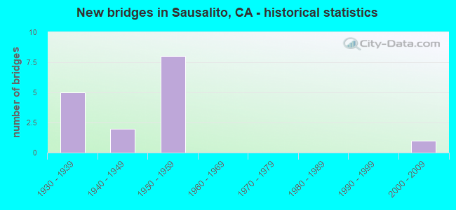
- New bridges - historical statistics
- 51930-1939
- 21940-1949
- 81950-1959
- 12000-2009

- Reconstructed bridges - Historical Statistics
- 11960-1969
- 01970-1979
- 01980-1989
- 11990-1999
- 12000-2009


- Bridge Condition - Deck
- 77.8%Good
- 22.2%Fair

- Bridge Condition - Superstructure
- 70.0%Good
- 10.0%Satisfactory
- 20.0%Fair

- Bridge Condition - Substructure
- 80.0%Good
- 20.0%Fair
Find on map >> Show street view
Structure Number: 27 003, Location: 04-MRN-101-12.19-SRF (Lat: 37.987925, Lng: -122.526358), Route carried "on" structure: US 101, Year Built: 1938, Year Reconstructed: 2009, Status: Open, Structure Length: 2.71m (8.89ft), Average Daily Traffic: 180,000 (year 2009), Average Future Daily Traffic: 260,151 (year 2038), Design Load: H 15, Features Intersected: LINCOLN AVE-N101 ON RAMP
Minimum Vertical Clearance: 30+ m (98+ ft), Kilometerpoint: 12.190, Lanes on structure: 9, Lanes under structure: 2, Base Highway Network: Yes (Inventory Route: 1, Subroute: 1), Owner: State Highway Agency, Approaching Roadway Width: 19.8m (65.0ft), Skew: 32 degrees, Material/Design: Prestressed concrete continuous, Design/Construction: Slab, Number Of Spans In Main Unit: 3, Length of Maximum Span: 14.3m (46.9ft), Curb-To-Curb Width: 37.2m (122.0ft), Out-to-Out Width: 38.7m (127.0ft)
Condition: Deck: Fair, Superstructure: Fair, Substructure: Good, Operating Rating: 41.1 metric tons, Method Used To Determine Operating Rating: Load Factor (LF), Inventory Rating: 24.6 metric tons, Method Used To Determine Inventory Rating: Load Factor (LF), Structural Evaluation: Somewhat better than minimum adequacy, Deck Geometry: Meets minimum limits, Underclear: High priority of corrective action, Approach Roadway Alignment: Equal to present desirable criteria, Designated Inspection Frequency: Every 24 months, Inspection Date: March 2021, Deck Structure Type: Concrete Cast-file-Place, Wearing Surface/Protective System: Wearing Surface: Bituminous
Find on map >> Show street view
Structure Number: 27 0038, Location: 04-MRN-101-0.32-SAUS (Lat: 37.835644, Lng: -122.484506), Route carried "on" structure: US 101, Year Built: 1935, Year Reconstructed: 1969, Status: Open, Structure Length: 0.82m (2.69ft), Average Daily Traffic: 106,000 (year 2009), Truck Traffic: 1%, Average Future Daily Traffic: 143,741 (year 2038), Design Load: HS 20, Features Intersected: SAUSALITO ROAD
Minimum Vertical Clearance: 30+ m (98+ ft), Kilometerpoint: 0.320, Lanes on structure: 8, Lanes under structure: 2, Base Highway Network: Yes (Inventory Route: 1, Subroute: 1), Owner: State Highway Agency, Approaching Roadway Width: 37.0m (121.4ft), Skew: 31 degrees, Material/Design: Concrete, Design/Construction: Slab, Number Of Spans In Main Unit: 1, Length of Maximum Span: 7.3m (24.0ft), Curb-To-Curb Width: 33.5m (109.9ft), Out-to-Out Width: 37.4m (122.7ft)
Condition: Deck: Good, Superstructure: Good, Substructure: Good, Operating Rating: 99.8 metric tons, Method Used To Determine Operating Rating: Load Factor (LF), Inventory Rating: 92.6 metric tons, Method Used To Determine Inventory Rating: Load Factor (LF), Structural Evaluation: Better than present minimum criteria, Deck Geometry: Meets minimum limits, Underclear: High priority of corrective action, Approach Roadway Alignment: Equal to present desirable criteria, Designated Inspection Frequency: Every 48 months, Inspection Date: May 2020
Find on map >> Show street view
Structure Number: 27 0042, Location: 04-MRN-101-3.33-SAUS (Lat: 37.871558, Lng: -122.506933), Route carried "on" structure: US 101, Year Built: 1943, Year Reconstructed: 1996, Status: Open, Structure Length: 2.82m (9.25ft), Average Daily Traffic: 106,000 (year 2009), Truck Traffic: 1%, Average Future Daily Traffic: 146,640 (year 2042), Design Load: HS 20, Features Intersected: DONAHUE ST/N. BRIDGE BLD
Minimum Vertical Clearance: 30+ m (98+ ft), Kilometerpoint: 3.330, Lanes on structure: 10, Lanes under structure: 3, Base Highway Network: Yes (Inventory Route: 1, Subroute: 1), Owner: State Highway Agency, Approaching Roadway Width: 49.5m (162.4ft), Skew: 39 degrees, Material/Design: Concrete continuous, Design/Construction: Slab, Number Of Spans In Main Unit: 5, Length of Maximum Span: 6.2m (20.3ft), Curb-To-Curb Width: 49.0m (160.8ft), Out-to-Out Width: 52.3m (171.6ft)
Condition: Deck: Good, Superstructure: Good, Substructure: Good, Operating Rating: 54.1 metric tons, Method Used To Determine Operating Rating: Assigned rating based on Load Factor Design (LFD) reported in metric tons, Inventory Rating: 32.4 metric tons, Method Used To Determine Inventory Rating: Assigned rating based on Load Factor Design (LFD) reported in metric tons, Structural Evaluation: Better than present minimum criteria, Deck Geometry: Superior to present desirable criteria, Underclear: High priority of corrective action, Approach Roadway Alignment: Better than present minimum criteria, Designated Inspection Frequency: Every 48 months, Inspection Date: May 2020, Deck Structure Type: Concrete Cast-file-Place, Wearing Surface/Protective System: Wearing Surface: Bituminous
Find on map >> Show street view
Structure Number: 27 0060F, Location: 04-MRN-101-9.94-SRF (Lat: 37.961464, Lng: -122.507836), Route carried "on" structure: Ramp US 101, Year Built: 2009, Status: Open, Structure Length: 43.50m (142.72ft), Average Daily Traffic: 22,200 (year 2009), Truck Traffic: 5%, Average Future Daily Traffic: 46,061 (year 2042), Design Load: HS 20+Mod, Features Intersected: US HIGHWAY 101
Minimum Vertical Clearance: 30+ m (98+ ft), Kilometerpoint: 9.940, Lanes on structure: 2, Lanes under structure: 8, Base Highway Network: Yes (Inventory Route: 1, Subroute: 1), Owner: State Highway Agency, Approaching Roadway Width: 11.7m (38.4ft), Material/Design: Prestressed concrete continuous, Design/Construction: Box Beam or Girders - Multiple, Number Of Spans In Main Unit: 10, Length of Maximum Span: 49.0m (160.8ft), Curb-To-Curb Width: 11.7m (38.4ft), Out-to-Out Width: 12.6m (41.3ft)
Condition: Deck: Good, Superstructure: Good, Substructure: Good, Operating Rating: 54.1 metric tons, Method Used To Determine Operating Rating: Assigned rating based on Load Factor Design (LFD) reported in metric tons, Inventory Rating: 32.4 metric tons, Method Used To Determine Inventory Rating: Assigned rating based on Load Factor Design (LFD) reported in metric tons, Structural Evaluation: Better than present minimum criteria, Deck Geometry: Superior to present desirable criteria, Underclear: Equal to present minimum criteria, Approach Roadway Alignment: Equal to present desirable criteria, Designated Inspection Frequency: Every 24 months, Inspection Date: May 2020, Deck Structure Type: Concrete Cast-file-Place
Find on map >> Show street view
Structure Number: 27 0063R, Location: 04-MRN-101-1.09-SAUS (Lat: 37.846158, Lng: -122.486269), Route carried "on" structure: US 101, Year Built: 1954, Status: Open, Structure Length: 9.69m (31.79ft), Average Daily Traffic: 53,000 (year 2009), Truck Traffic: 1%, Average Future Daily Traffic: 72,592 (year 2042), Design Load: HS 20, Features Intersected: HILLSIDE
Minimum Vertical Clearance: 30+ m (98+ ft), Kilometerpoint: 1.090, Lanes on structure: 4, Base Highway Network: Yes (Inventory Route: 1, Subroute: 1), Owner: State Highway Agency, Approaching Roadway Width: 12.2m (40.0ft), Material/Design: Concrete continuous, Design/Construction: Tee Beam, Number Of Spans In Main Unit: 7, Length of Maximum Span: 14.6m (47.9ft), Curb-To-Curb Width: 12.2m (40.0ft), Out-to-Out Width: 13.1m (43.0ft)
Condition: Deck: Good, Superstructure: Good, Substructure: Good, Operating Rating: 37.3 metric tons, Method Used To Determine Operating Rating: Load and Resistance Factor Rating (LRFR) rating reported by rating factor(RF) method using HL-93 loadings, Inventory Rating: 28.8 metric tons, Method Used To Determine Inventory Rating: Load and Resistance Factor Rating (LRFR) rating reported by rating factor(RF) method using HL-93 loadings, Structural Evaluation: Better than present minimum criteria, Deck Geometry: High priority of replacement, Approach Roadway Alignment: Equal to present minimum criteria, Designated Inspection Frequency: Every 24 months, Inspection Date: May 2020, Deck Structure Type: Concrete Cast-file-Place
Find on map >> Show street view
Structure Number: 27 0064R, Location: 04-MRN-101-1.19-SAUS (Lat: 37.847456, Lng: -122.487361), Route carried "on" structure: US 101, Year Built: 1954, Status: Open, Structure Length: 8.23m (27.00ft), Average Daily Traffic: 53,000 (year 2009), Truck Traffic: 1%, Average Future Daily Traffic: 72,592 (year 2042), Design Load: HS 20, Features Intersected: HILLSIDE
Minimum Vertical Clearance: 30+ m (98+ ft), Kilometerpoint: 1.190, Lanes on structure: 4, Base Highway Network: Yes (Inventory Route: 1, Subroute: 1), Owner: State Highway Agency, Approaching Roadway Width: 13.1m (43.0ft), Material/Design: Concrete continuous, Design/Construction: Tee Beam, Number Of Spans In Main Unit: 6, Length of Maximum Span: 14.6m (47.9ft), Curb-To-Curb Width: 12.2m (40.0ft), Out-to-Out Width: 12.9m (42.3ft)
Condition: Deck: Good, Superstructure: Fair, Substructure: Good, Operating Rating: 41.7 metric tons, Method Used To Determine Operating Rating: Load Factor (LF), Inventory Rating: 24.5 metric tons, Method Used To Determine Inventory Rating: Load Factor (LF), Structural Evaluation: Somewhat better than minimum adequacy, Deck Geometry: High priority of replacement, Approach Roadway Alignment: Equal to present minimum criteria, Designated Inspection Frequency: Every 24 months, Inspection Date: May 2020, Deck Structure Type: Concrete Cast-file-Place
Find on map >> Show street view
Structure Number: 27 0066, Location: 04-MRN-101-1.52-SAUS (Lat: 37.851242, Lng: -122.490931), Route carried "on" structure: City street , Year Built: 1954, Status: Open, Structure Length: 9.57m (31.40ft), Average Daily Traffic: 2,512 (year 2003), Truck Traffic: 2%, Average Future Daily Traffic: 2,914 (year 2042), Design Load: HS 20, Features Intersected: U.S. HIGHWAY 101, Facility Carried by Structure: WOLFBACK RIDGE RD
Minimum Vertical Clearance: 30+ m (98+ ft), Kilometerpoint: 0.000, Lanes on structure: 2, Lanes under structure: 10, Owner: State Highway Agency, Approaching Roadway Width: 8.5m (27.9ft), Skew: 3 degrees, Material/Design: Concrete continuous, Design/Construction: Tee Beam, Number Of Spans In Main Unit: 6, Length of Maximum Span: 21.0m (68.9ft), Curb or Sidewalk Widths: Left: 1.5m (4.9ft), Right: 0.5m (1.6ft), Curb-To-Curb Width: 7.9m (25.9ft), Out-to-Out Width: 10.8m (35.4ft)
Condition: Deck: Fair, Superstructure: Good, Substructure: Good, Operating Rating: 49.6 metric tons, Method Used To Determine Operating Rating: Load Factor (LF), Inventory Rating: 29.8 metric tons, Method Used To Determine Inventory Rating: Load Factor (LF), Structural Evaluation: Better than present minimum criteria, Deck Geometry: High priority of corrective action, Underclear: High priority of corrective action, Approach Roadway Alignment: Equal to present desirable criteria, Designated Inspection Frequency: Every 24 months, Inspection Date: May 2020, Deck Structure Type: Concrete Cast-file-Place
Find on map >> Show street view
Structure Number: 27 0067, Location: 04-MRN-101-1.68-SAUS (Lat: 37.852850, Lng: -122.492236), Route carried "on" structure: US 101, Year Built: 1954, Status: Open, Structure Length: 1.22m (4.00ft), Average Daily Traffic: 106,000 (year 2009), Truck Traffic: 1%, Average Future Daily Traffic: 146,640 (year 2042), Design Load: H 20, Features Intersected: US 101 ON & OFF RAMPS
Minimum Vertical Clearance: 30+ m (98+ ft), Kilometerpoint: 1.680, Lanes on structure: 8, Lanes under structure: 2, Base Highway Network: Yes (Inventory Route: 1, Subroute: 1), Owner: State Highway Agency, Approaching Roadway Width: 35.4m (116.1ft), Skew: 3 degrees, Material/Design: Concrete, Design/Construction: Slab, Number Of Spans In Main Unit: 1, Length of Maximum Span: 11.4m (37.4ft), Curb-To-Curb Width: 35.4m (116.1ft), Out-to-Out Width: 37.3m (122.4ft)
Condition: Deck: Good, Superstructure: Good, Substructure: Good, Operating Rating: 99.8 metric tons, Method Used To Determine Operating Rating: Load Factor (LF), Inventory Rating: 66.7 metric tons, Method Used To Determine Inventory Rating: Load Factor (LF), Structural Evaluation: Better than present minimum criteria, Deck Geometry: Equal to present minimum criteria, Underclear: High priority of corrective action, Approach Roadway Alignment: Better than present minimum criteria, Designated Inspection Frequency: Every 48 months, Inspection Date: May 2020, Deck Structure Type: Concrete Cast-file-Place, Wearing Surface/Protective System: Wearing Surface: Bituminous
Find on map >> Show street view
Structure Number: 27C0053, Location: 0.3 KM EAST OF RTE 101 (Lat: 37.838008, Lng: -122.483031), Route carried "on" structure: County highway , Year Built: 1938, Status: Open, Structure Length: 0.98m (3.22ft), Average Daily Traffic: 7,201 (year 2016), Truck Traffic: 2%, Average Future Daily Traffic: 9,429 (year 2038), Design Load: H 15, Features Intersected: BUNKER ROAD, Facility Carried by Structure: ALEXANDER AVE
Minimum Vertical Clearance: 30+ m (98+ ft), Kilometerpoint: 0.000, Lanes on structure: 2, Lanes under structure: 2, Owner: Local Toll Authority, Approaching Roadway Width: 11.0m (36.1ft), Skew: 4 degrees, Material/Design: Concrete, Design/Construction: Arch - Deck, Number Of Spans In Main Unit: 1, Length of Maximum Span: 7.3m (24.0ft)
Condition: Superstructure: Satisfactory, Substructure: Fair, Operating Rating: 87.8 metric tons, Method Used To Determine Operating Rating: Load and Resistance Factor Rating (LRFR) rating reported by rating factor(RF) method using HL-93 loadings, Inventory Rating: 67.7 metric tons, Method Used To Determine Inventory Rating: Load and Resistance Factor Rating (LRFR) rating reported by rating factor(RF) method using HL-93 loadings, Structural Evaluation: Somewhat better than minimum adequacy, Underclear: High priority of corrective action, Approach Roadway Alignment: Equal to present desirable criteria, Designated Inspection Frequency: Every 24 months, Inspection Date: March 2020
Find on map >> Show street view
Structure Number: 27C0054, Location: 1.3 KM EAST OF SR 101 (Lat: 37.843414, Lng: -122.478289), Route carried "on" structure: County highway , Year Built: 1938, Status: Open, Structure Length: 1.19m (3.90ft), Average Daily Traffic: 7,201 (year 2016), Truck Traffic: 2%, Average Future Daily Traffic: 9,182 (year 2042), Design Load: H 15, Features Intersected: EAST ROAD, Facility Carried by Structure: ALEXANDER AVENUE
Minimum Vertical Clearance: 30+ m (98+ ft), Kilometerpoint: 0.000, Lanes on structure: 2, Lanes under structure: 1, Owner: Local Toll Authority, Approaching Roadway Width: 11.0m (36.1ft), Skew: 5 degrees, Material/Design: Concrete, Design/Construction: Tee Beam, Number Of Spans In Main Unit: 1, Length of Maximum Span: 10.4m (34.1ft), Curb-To-Curb Width: 11.0m (36.1ft), Out-to-Out Width: 12.0m (39.4ft)
Condition: Deck: Good, Superstructure: Good, Substructure: Fair, Operating Rating: 23.0 metric tons, Method Used To Determine Operating Rating: Load and Resistance Factor Rating (LRFR) rating reported by rating factor(RF) method using HL-93 loadings, Inventory Rating: 17.8 metric tons, Method Used To Determine Inventory Rating: Load and Resistance Factor Rating (LRFR) rating reported by rating factor(RF) method using HL-93 loadings, Structural Evaluation: Meets minimum limits, Deck Geometry: Meets minimum limits, Underclear: Meets minimum limits, Approach Roadway Alignment: Equal to present desirable criteria, Designated Inspection Frequency: Every 24 months, Inspection Date: March 2020, Deck Structure Type: Concrete Cast-file-Place, Wearing Surface/Protective System: Wearing Surface: Bituminous
Find on map >> Show street view
Structure Number: 27 001, Location: 04-MRN-101-4.03-SAUS (Lat: 37.879025, Lng: -122.515044), Route carried "under" structure: State highway 1, Year Built: 1957, Structure Length: 0. m, Average Daily Traffic: 30,500 (year 2009), Truck Traffic: 2%, Features Intersected: SR 1, RICH BY, FRNTGE RD
Minimum Vertical Clearance: 5.13m (16.83ft), Kilometerpoint: 0.000, Lanes on structure: 10, Lanes under structure: 3, Material/Design: Prestressed concrete, Design/Construction: Stringer/Multi-beam, Length of Maximum Span: 24.4m (80.1ft)
Find on map >> Show street view
Structure Number: 27 0038, Location: 04-MRN-101-0.32-SAUS (Lat: 37.835644, Lng: -122.484506), Route carried "under" structure: Business City street , Year Built: 1935, Structure Length: 0. m, Average Daily Traffic: 10,415 (year 2003), Truck Traffic: 3%, Features Intersected: SAUSALITO ROAD, Facility Carried by Structure: U.S. HIGHWAY 101
Minimum Vertical Clearance: 4.32m (14.17ft), Kilometerpoint: 0.000, Lanes on structure: 8, Lanes under structure: 2, Material/Design: Concrete, Design/Construction: Slab, Length of Maximum Span: 7.3m (24.0ft)
Find on map >> Show street view
Structure Number: 27 0042, Location: 04-MRN-101-3.33-SAUS (Lat: 37.871558, Lng: -122.506933), Route carried "under" structure: City street , Year Built: 1943, Structure Length: 0. m, Average Daily Traffic: 5,920 (year 2003), Truck Traffic: 3%, Features Intersected: DONAHUE ST/N. BRIDGE BLD, Facility Carried by Structure: U.S. HIGHWAY 101
Minimum Vertical Clearance: 4.67m (15.32ft), Kilometerpoint: 0.000, Lanes on structure: 10, Lanes under structure: 3, Material/Design: Concrete continuous, Design/Construction: Slab, Length of Maximum Span: 6.2m (20.3ft)
Find on map >> Show street view
Structure Number: 27 0066, Location: 04-MRN-101-1.52-SAUS (Lat: 37.851242, Lng: -122.490931), Route carried "under" structure: US 101, Year Built: 1954, Structure Length: 0. m, Average Daily Traffic: 106,000 (year 2009), Truck Traffic: 1%, Features Intersected: U.S. HIGHWAY 101, Facility Carried by Structure: WOLFBACK RIDGE RD
Minimum Vertical Clearance: 5.76m (18.90ft), Kilometerpoint: 1.520, Lanes on structure: 2, Lanes under structure: 8, Material/Design: Concrete continuous, Design/Construction: Tee Beam, Length of Maximum Span: 21.0m (68.9ft)
Find on map >> Show street view
Structure Number: 27 0066, Location: 04-MRN-101-1.52-SAUS (Lat: 37.851242, Lng: -122.490931), Route carried "under" structure: City street , Year Built: 1954, Structure Length: 0. m, Average Daily Traffic: 1,676 (year 2003), Truck Traffic: 2%, Features Intersected: U.S. HIGHWAY 101, Facility Carried by Structure: WOLFBACK RIDGE RD
Minimum Vertical Clearance: 5.38m (17.65ft), Kilometerpoint: 0.000, Lanes on structure: 2, Lanes under structure: 2, Material/Design: Concrete continuous, Design/Construction: Tee Beam, Length of Maximum Span: 21.0m (68.9ft)
Find on map >> Show street view
Structure Number: 27 0067, Location: 04-MRN-101-1.68-SAUS (Lat: 37.852850, Lng: -122.492236), Route carried "under" structure: Ramp City street , Year Built: 1954, Structure Length: 0. m, Average Daily Traffic: 1,676 (year 2003), Truck Traffic: 2%, Features Intersected: US 101 ON & OFF RAMPS, Facility Carried by Structure: U.S. HIGHWAY 101
Minimum Vertical Clearance: 4.62m (15.16ft), Kilometerpoint: 0.000, Lanes on structure: 8, Lanes under structure: 2, Material/Design: Concrete, Design/Construction: Slab, Length of Maximum Span: 11.4m (37.4ft)