Bridge Statistics for Santa Maria, California (CA)
Condition, Traffic, Stress, Structural Evaluation, Project Costs
- National Bridge Inventory (NBI) Statistics
- 33Number of bridges
- 502ft / 153mTotal length
- 596,208Total average daily traffic
- 36,133Total average daily truck traffic
- National Bridge Inventory (NBI) Registered Bridges for Santa Maria
- No street view available for this location
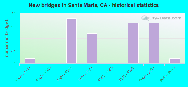
- New bridges - historical statistics
- 11940-1949
- 91960-1969
- 61970-1979
- 81990-1999
- 82000-2009
- 12010-2019

- Reconstructed bridges - Historical Statistics
- 31980-1989
- 01990-1999
- 22000-2009


- Bridge Condition - Deck
- 57.9%Good
- 5.3%Satisfactory
- 36.8%Fair

- Bridge Condition - Superstructure
- 75.0%Good
- 25.0%Fair

- Bridge Condition - Substructure
- 95.0%Good
- 5.0%Fair

- Bridge Condition - Channel
- 29.4%Excellent
- 52.9%Very good
- 5.9%Good
- 11.8%Fair
Find on map >> Show street view
Structure Number: 49 0111, Location: 05-SLO-101-0.09 (Lat: 34.985681, Lng: -120.432931), Route carried "on" structure: US 101, Year Built: 1962, Year Reconstructed: 2014, Status: Open, Structure Length: 63.72m (209.06ft), Average Daily Traffic: 56,000 (year 2009), Truck Traffic: 7%, Average Future Daily Traffic: 112,090 (year 2042), Design Load: HL 93, Features Intersected: SANTA MARIA RIVER
Minimum Vertical Clearance: 30+ m (98+ ft), Kilometerpoint: 0.090, Lanes on structure: 6, Base Highway Network: Yes (Inventory Route: 1, Subroute: 1), Owner: State Highway Agency, Approaching Roadway Width: 34.1m (111.9ft), Skew: 34 degrees, Material/Design: Prestressed concrete continuous, Design/Construction: Stringer/Multi-beam, Number Of Spans In Main Unit: 29, Length of Maximum Span: 22.4m (73.5ft), Curb or Sidewalk Widths: Left: 3.6m (11.8ft), Right: 0.0m, Curb-To-Curb Width: 34.1m (111.9ft), Out-to-Out Width: 39.7m (130.2ft)
Condition: Deck: Fair, Superstructure: Good, Substructure: Good, Channel: Fair, Operating Rating: 50.5 metric tons, Method Used To Determine Operating Rating: Load and Resistance Factor Rating (LRFR) rating reported by rating factor(RF) method using HL-93 loadings, Inventory Rating: 33.4 metric tons, Method Used To Determine Inventory Rating: Load and Resistance Factor Rating (LRFR) rating reported by rating factor(RF) method using HL-93 loadings, Structural Evaluation: Better than present minimum criteria, Deck Geometry: Superior to present desirable criteria, Waterway Adequacy: Superior to present desirable criteria, Approach Roadway Alignment: Better than present minimum criteria, Designated Inspection Frequency: Every 24 months, Inspection Date: January 2022, Deck Structure Type: Concrete Cast-file-Place
Find on map >> Show street view
Structure Number: 49 0121R, Location: 05-SLO-101-0.80 (Lat: 34.996117, Lng: -120.434522), Route carried "on" structure: US 101, Year Built: 1962, Status: Open, Structure Length: 3.43m (11.25ft), Average Daily Traffic: 25,500 (year 2009), Average Future Daily Traffic: 49,706 (year 2038), Design Load: HS 20, Features Intersected: ST RTE 166 (@PM 8.93)
Minimum Vertical Clearance: 30+ m (98+ ft), Kilometerpoint: 0.800, Lanes on structure: 2, Lanes under structure: 2, Base Highway Network: Yes (Inventory Route: 1, Subroute: 1), Owner: State Highway Agency, Approaching Roadway Width: 11.4m (37.4ft), Material/Design: Concrete continuous, Design/Construction: Tee Beam, Number Of Spans In Main Unit: 3, Length of Maximum Span: 14.3m (46.9ft), Curb-To-Curb Width: 11.3m (37.1ft), Out-to-Out Width: 12.1m (39.7ft)
Condition: Deck: Good, Superstructure: Good, Substructure: Good, Operating Rating: 52.2 metric tons, Method Used To Determine Operating Rating: Load and Resistance Factor Rating (LRFR) rating reported by rating factor(RF) method using HL-93 loadings, Inventory Rating: 40.2 metric tons, Method Used To Determine Inventory Rating: Load and Resistance Factor Rating (LRFR) rating reported by rating factor(RF) method using HL-93 loadings, Structural Evaluation: Better than present minimum criteria, Deck Geometry: Equal to present minimum criteria, Underclear: Somewhat better than minimum adequacy, Approach Roadway Alignment: Better than present minimum criteria, Designated Inspection Frequency: Every 48 months, Inspection Date: January 2020, Deck Structure Type: Concrete Cast-file-Place, Wearing Surface/Protective System: Wearing Surface: Bituminous
Find on map >> Show street view
Structure Number: 51 004, Location: 05-SB-101-89.13-SMRA (Lat: 34.960211, Lng: -120.418858), Route carried "on" structure: City street J083, Year Built: 1972, Status: Open, Structure Length: 9.33m (30.61ft), Average Daily Traffic: 48,000 (year 2010), Truck Traffic: 1%, Average Future Daily Traffic: 79,116 (year 2040), Design Load: HS 20+Mod, Features Intersected: US HWY 101 & BRADLEY CHN, Facility Carried by Structure: ALVIN AVE
Minimum Vertical Clearance: 30+ m (98+ ft), Kilometerpoint: 0.000, Lanes on structure: 4, Lanes under structure: 4, Owner: State Highway Agency, Approaching Roadway Width: 19.5m (64.0ft), Skew: 2 degrees, Material/Design: Prestressed concrete continuous, Design/Construction: Stringer/Multi-beam, Number Of Spans In Main Unit: 3, Length of Maximum Span: 33.2m (108.9ft), Curb or Sidewalk Widths: Left: 1.5m (4.9ft), Right: 1.5m (4.9ft), Curb-To-Curb Width: 19.5m (64.0ft), Out-to-Out Width: 23.2m (76.1ft)
Condition: Deck: Good, Superstructure: Good, Substructure: Good, Channel: Very good, Operating Rating: 46.0 metric tons, Method Used To Determine Operating Rating: Load and Resistance Factor Rating (LRFR) rating reported by rating factor(RF) method using HL-93 loadings, Inventory Rating: 23.3 metric tons, Method Used To Determine Inventory Rating: Load and Resistance Factor Rating (LRFR) rating reported by rating factor(RF) method using HL-93 loadings, Structural Evaluation: Somewhat better than minimum adequacy, Deck Geometry: Better than present minimum criteria, Underclear: Better than present minimum criteria, Waterway Adequacy: Superior to present desirable criteria, Approach Roadway Alignment: Equal to present desirable criteria, Designated Inspection Frequency: Every 24 months, Inspection Date: December 2020, Deck Structure Type: Concrete Cast-file-Place
Find on map >> Show street view
Structure Number: 51 0199, Location: 05-SB-101-87.60 (Lat: 34.938242, Lng: -120.418089), Route carried "on" structure: US 101, Year Built: 1997, Status: Open, Structure Length: 5.83m (19.13ft), Average Daily Traffic: 3,210 (year 2010), Truck Traffic: 3%, Average Future Daily Traffic: 5,118 (year 2042), Design Load: HS 20+Mod, Features Intersected: US HIGHWAY 101, Facility Carried by Structure: STOWELL RD
Minimum Vertical Clearance: 30+ m (98+ ft), Kilometerpoint: 87.600, Lanes on structure: 4, Lanes under structure: 6, Base Highway Network: Yes (Inventory Route: 1, Subroute: 1), Owner: State Highway Agency, Approaching Roadway Width: 21.2m (69.6ft), Material/Design: Prestressed concrete continuous, Design/Construction: Box Beam or Girders - Multiple, Number Of Spans In Main Unit: 2, Length of Maximum Span: 30.6m (100.4ft), Curb or Sidewalk Widths: Left: 1.5m (4.9ft), Right: 1.5m (4.9ft), Curb-To-Curb Width: 21.2m (69.6ft), Out-to-Out Width: 24.8m (81.4ft)
Condition: Deck: Fair, Superstructure: Good, Substructure: Good, Operating Rating: 54.1 metric tons, Method Used To Determine Operating Rating: Assigned rating based on Load Factor Design (LFD) reported in metric tons, Inventory Rating: 32.4 metric tons, Method Used To Determine Inventory Rating: Assigned rating based on Load Factor Design (LFD) reported in metric tons, Structural Evaluation: Better than present minimum criteria, Deck Geometry: Better than present minimum criteria, Underclear: Meets minimum limits, Approach Roadway Alignment: Equal to present desirable criteria, Designated Inspection Frequency: Every 24 months, Inspection Date: December 2020, Deck Structure Type: Concrete Cast-file-Place
Find on map >> Show street view
Structure Number: 51 02, Location: 05-SB-101-88.10-SMRA (Lat: 34.945525, Lng: -120.417497), Route carried "on" structure: US 101, Year Built: 1962, Year Reconstructed: 2008, Status: Open, Structure Length: 6.40m (21.00ft), Average Daily Traffic: 58,000 (year 2009), Truck Traffic: 7%, Average Future Daily Traffic: 105,522 (year 2042), Design Load: HS 20, Features Intersected: JONES STREET
Minimum Vertical Clearance: 30+ m (98+ ft), Kilometerpoint: 88.100, Lanes on structure: 6, Lanes under structure: 2, Base Highway Network: Yes (Inventory Route: 1, Subroute: 1), Owner: State Highway Agency, Approaching Roadway Width: 34.0m (111.5ft), Skew: 30 degrees, Material/Design: Concrete continuous, Design/Construction: Tee Beam, Number Of Spans In Main Unit: 4, Length of Maximum Span: 23.2m (76.1ft), Curb-To-Curb Width: 33.5m (109.9ft), Out-to-Out Width: 34.3m (112.5ft)
Condition: Deck: Fair, Superstructure: Good, Substructure: Good, Operating Rating: 35.6 metric tons, Method Used To Determine Operating Rating: Load and Resistance Factor Rating (LRFR) rating reported by rating factor(RF) method using HL-93 loadings, Inventory Rating: 27.5 metric tons, Method Used To Determine Inventory Rating: Load and Resistance Factor Rating (LRFR) rating reported by rating factor(RF) method using HL-93 loadings, Structural Evaluation: Equal to present minimum criteria, Deck Geometry: Superior to present desirable criteria, Underclear: Superior to present desirable criteria, Approach Roadway Alignment: Equal to present desirable criteria, Designated Inspection Frequency: Every 24 months, Inspection Date: December 2020, Deck Structure Type: Concrete Cast-file-Place
Find on map >> Show street view
Structure Number: 51 0202, Location: 05-SB-101-89.69-SMRA (Lat: 34.967606, Lng: -120.423306), Route carried "on" structure: Alternate City street , Year Built: 2001, Status: Open, Structure Length: 6.60m (21.65ft), Average Daily Traffic: 500 (year 2011), Truck Traffic: 5%, Average Future Daily Traffic: 1,020 (year 2040), Design Load: HS 20+Mod, Features Intersected: US HIGHWAY 101, Facility Carried by Structure: DONOVAN RD
Minimum Vertical Clearance: 30+ m (98+ ft), Kilometerpoint: 0.000, Lanes on structure: 4, Lanes under structure: 8, Owner: State Highway Agency, Approaching Roadway Width: 20.0m (65.6ft), Skew: 2 degrees, Material/Design: Prestressed concrete continuous, Design/Construction: Box Beam or Girders - Multiple, Number Of Spans In Main Unit: 2, Length of Maximum Span: 33.0m (108.3ft), Curb or Sidewalk Widths: Left: 1.5m (4.9ft), Right: 1.5m (4.9ft), Curb-To-Curb Width: 19.7m (64.6ft), Out-to-Out Width: 23.3m (76.4ft)
Condition: Deck: Good, Superstructure: Good, Substructure: Good, Operating Rating: 54.1 metric tons, Method Used To Determine Operating Rating: Assigned rating based on Load Factor Design (LFD) reported in metric tons, Inventory Rating: 32.4 metric tons, Method Used To Determine Inventory Rating: Assigned rating based on Load Factor Design (LFD) reported in metric tons, Structural Evaluation: Better than present minimum criteria, Deck Geometry: Better than present minimum criteria, Underclear: Equal to present minimum criteria, Approach Roadway Alignment: Equal to present desirable criteria, Designated Inspection Frequency: Every 24 months, Inspection Date: December 2020, Deck Structure Type: Concrete Cast-file-Place
Find on map >> Show street view
Structure Number: 51 0203E, Location: 05-SB-135-17.78-SMRA (Lat: 34.981078, Lng: -120.431661), Route carried "on" structure: State highway 135, Year Built: 1962, Status: Open, Structure Length: 6.06m (19.88ft), Average Daily Traffic: 20,900 (year 2009), Truck Traffic: 4%, Average Future Daily Traffic: 19,787 (year 2043), Design Load: HS 20, Features Intersected: US HWY 101 (@PM 90.75)
Minimum Vertical Clearance: 30+ m (98+ ft), Kilometerpoint: 17.780, Lanes on structure: 2, Lanes under structure: 6, Base Highway Network: Yes (Inventory Route: 1, Subroute: 1), Owner: State Highway Agency, Approaching Roadway Width: 12.2m (40.0ft), Skew: 1 degrees, Material/Design: Concrete continuous, Design/Construction: Tee Beam, Number Of Spans In Main Unit: 4, Length of Maximum Span: 15.7m (51.5ft), Curb or Sidewalk Widths: Left: 0.6m (2.0ft), Right: 0.6m (2.0ft), Curb-To-Curb Width: 8.5m (27.9ft), Out-to-Out Width: 10.4m (34.1ft)
Condition: Deck: Satisfactory, Superstructure: Good, Substructure: Good, Operating Rating: 38.2 metric tons, Method Used To Determine Operating Rating: Load and Resistance Factor Rating (LRFR) rating reported by rating factor(RF) method using HL-93 loadings, Inventory Rating: 29.5 metric tons, Method Used To Determine Inventory Rating: Load and Resistance Factor Rating (LRFR) rating reported by rating factor(RF) method using HL-93 loadings, Structural Evaluation: Better than present minimum criteria, Deck Geometry: Meets minimum limits, Underclear: High priority of corrective action, Approach Roadway Alignment: Equal to present desirable criteria, Designated Inspection Frequency: Every 24 months, Inspection Date: May 2021, Deck Structure Type: Concrete Cast-file-Place
Find on map >> Show street view
Structure Number: 51 0238, Location: 05-SB-135-17.55-SMRA (Lat: 34.978575, Lng: -120.434783), Route carried "on" structure: State highway 135, Year Built: 1974, Year Reconstructed: 1985, Status: Open, Structure Length: 0.94m (3.08ft), Average Daily Traffic: 20,900 (year 2009), Truck Traffic: 4%, Average Future Daily Traffic: 19,787 (year 2043), Design Load: HS 20, Features Intersected: BRADLEY CHANNEL
Minimum Vertical Clearance: 30+ m (98+ ft), Kilometerpoint: 17.550, Lanes on structure: 5, Base Highway Network: Yes (Inventory Route: 1, Subroute: 1), Owner: State Highway Agency, Approaching Roadway Width: 23.8m (78.1ft), Skew: 21 degrees, Material/Design: Concrete continuous, Design/Construction: Culvert, Number Of Spans In Main Unit: 5, Length of Maximum Span: 1.5m (4.9ft), Curb or Sidewalk Widths: Left: 2.4m (7.9ft), Right: 3.4m (11.2ft)
Condition: Channel: Very good, Culverts: Satisfactory, Operating Rating: 39.2 metric tons, Method Used To Determine Operating Rating: Load Factor (LF), Inventory Rating: 23.7 metric tons, Method Used To Determine Inventory Rating: Load Factor (LF), Structural Evaluation: Somewhat better than minimum adequacy, Waterway Adequacy: Equal to present desirable criteria, Approach Roadway Alignment: Equal to present desirable criteria, Designated Inspection Frequency: Every 24 months, Inspection Date: May 2021
Find on map >> Show street view
Structure Number: 51 0306, Location: 05-SB-101-86.59 (Lat: 34.923461, Lng: -120.418211), Route carried "on" structure: County highway , Year Built: 1997, Status: Open, Structure Length: 6.00m (19.69ft), Average Daily Traffic: 5,574 (year 2007), Truck Traffic: 7%, Average Future Daily Traffic: 7,805 (year 2040), Design Load: HS 20+Mod, Features Intersected: US HIGHWAY 101, Facility Carried by Structure: BETTERAVIA ROAD
Minimum Vertical Clearance: 30+ m (98+ ft), Kilometerpoint: 86.590, Lanes on structure: 7, Lanes under structure: 6, Base Highway Network: Yes, Owner: State Highway Agency, Approaching Roadway Width: 30.5m (100.1ft), Material/Design: Prestressed concrete continuous, Design/Construction: Box Beam or Girders - Multiple, Number Of Spans In Main Unit: 2, Length of Maximum Span: 31.5m (103.3ft), Curb or Sidewalk Widths: Left: 0.0m, Right: 1.5m (4.9ft), Curb-To-Curb Width: 30.5m (100.1ft), Out-to-Out Width: 32.8m (107.6ft)
Condition: Deck: Good, Superstructure: Good, Substructure: Good, Operating Rating: 54.1 metric tons, Method Used To Determine Operating Rating: Assigned rating based on Load Factor Design (LFD) reported in metric tons, Inventory Rating: 32.4 metric tons, Method Used To Determine Inventory Rating: Assigned rating based on Load Factor Design (LFD) reported in metric tons, Structural Evaluation: Better than present minimum criteria, Deck Geometry: Better than present minimum criteria, Underclear: Equal to present minimum criteria, Approach Roadway Alignment: Equal to present desirable criteria, Designated Inspection Frequency: Every 24 months, Inspection Date: December 2020, Deck Structure Type: Concrete Cast-file-Place
Find on map >> Show street view
Structure Number: 51 0309S, Location: 05-SB-101-88.54-SMRA (Lat: 34.951433, Lng: -120.416764), Route carried "on" structure: Ramp US 101, Year Built: 1997, Status: Open, Structure Length: 0.66m (2.17ft), Average Daily Traffic: 14,500 (year 2009), Truck Traffic: 6%, Average Future Daily Traffic: 25,686 (year 2036), Features Intersected: BRADLEY CHANNEL
Minimum Vertical Clearance: 30+ m (98+ ft), Kilometerpoint: 88.540, Lanes on structure: 2, Owner: State Highway Agency, Approaching Roadway Width: 35.1m (115.2ft), Skew: 2 degrees, Material/Design: Concrete continuous, Design/Construction: Culvert, Number Of Spans In Main Unit: 2, Length of Maximum Span: 3.0m (9.8ft), Curb-To-Curb Width: 35.1m (115.2ft), Out-to-Out Width: 36.0m (118.1ft)
Condition: Channel: Excellent, Culverts: Satisfactory, Operating Rating: 54.1 metric tons, Method Used To Determine Operating Rating: Field evaluation and documented engineering judgment, Inventory Rating: 32.4 metric tons, Method Used To Determine Inventory Rating: Field evaluation and documented engineering judgment, Structural Evaluation: Equal to present minimum criteria, Deck Geometry: Superior to present desirable criteria, Waterway Adequacy: Better than present minimum criteria, Approach Roadway Alignment: Equal to present desirable criteria, Designated Inspection Frequency: Every 48 months, Inspection Date: December 2018, Deck Structure Type: Concrete Cast-file-Place
Find on map >> Show street view
Structure Number: 51 0310S, Location: 05-SB-101-88.68-SMRA (Lat: 34.953636, Lng: -120.416411), Route carried "on" structure: Ramp US 101, Year Built: 1997, Status: Open, Structure Length: 3.10m (10.17ft), Average Daily Traffic: 16,500 (year 2009), Truck Traffic: 6%, Average Future Daily Traffic: 28,728 (year 2036), Features Intersected: BRADLEY CHANNEL
Minimum Vertical Clearance: 30+ m (98+ ft), Kilometerpoint: 88.680, Lanes on structure: 2, Owner: State Highway Agency, Approaching Roadway Width: 10.8m (35.4ft), Skew: 6 degrees, Material/Design: Concrete continuous, Design/Construction: Culvert, Number Of Spans In Main Unit: 2, Length of Maximum Span: 3.7m (12.1ft)
Condition: Channel: Excellent, Culverts: Satisfactory, Operating Rating: 54.1 metric tons, Method Used To Determine Operating Rating: Field evaluation and documented engineering judgment, Inventory Rating: 32.4 metric tons, Method Used To Determine Inventory Rating: Field evaluation and documented engineering judgment, Structural Evaluation: Equal to present minimum criteria, Waterway Adequacy: Better than present minimum criteria, Approach Roadway Alignment: Equal to present desirable criteria, Designated Inspection Frequency: Every 48 months, Inspection Date: December 2018
Find on map >> Show street view
Structure Number: 51C0035, Location: 2.0 MI N ASSOCIATED RD (Lat: 34.875597, Lng: -120.514225), Route carried "on" structure: County highway , Year Built: 1943, Status: Open, Structure Length: 6.97m (22.87ft), Average Daily Traffic: 1,003 (year 2009), Truck Traffic: 6%, Average Future Daily Traffic: 4,011 (year 2038), Features Intersected: UP RR & AMTRAK, Facility Carried by Structure: BLACK ROAD
Minimum Vertical Clearance: 30+ m (98+ ft), Kilometerpoint: 0.000, Lanes on structure: 2, Owner: County Highway Agency, Approaching Roadway Width: 7.9m (25.9ft), Skew: 9 degrees, Material/Design: Steel, Design/Construction: Stringer/Multi-beam, Number Of Spans In Main Unit: 1, Number Of Approach Spans: 8, Length of Maximum Span: 21.6m (70.9ft), Curb or Sidewalk Widths: Left: 0.8m (2.6ft), Right: 0.8m (2.6ft), Curb-To-Curb Width: 7.9m (25.9ft), Out-to-Out Width: 9.5m (31.2ft)
Condition: Deck: Good, Superstructure: Fair, Substructure: Good, Operating Rating: 22.4 metric tons, Method Used To Determine Operating Rating: Load and Resistance Factor Rating (LRFR) rating reported by rating factor(RF) method using HL-93 loadings, Inventory Rating: 17.2 metric tons, Method Used To Determine Inventory Rating: Load and Resistance Factor Rating (LRFR) rating reported by rating factor(RF) method using HL-93 loadings, Structural Evaluation: Meets minimum limits, Deck Geometry: Meets minimum limits, Underclear: Somewhat better than minimum adequacy, Approach Roadway Alignment: Equal to present minimum criteria, Designated Inspection Frequency: Every 24 months, Critical Feature Inspection Frequency: Every 24 months, Inspection Date: January 2021, Critical Feature Inspection Date: September 2020, Deck Structure Type: Concrete Cast-file-Place
Find on map >> Show street view
Structure Number: 51C0313, Location: 1 MI E PHILBRIC RD (Lat: 34.923164, Lng: -120.356233), Route carried "on" structure: County highway , Year Built: 1960, Status: Open, Structure Length: 8.32m (27.30ft), Average Daily Traffic: 4,021 (year 2009), Truck Traffic: 11%, Average Future Daily Traffic: 7,851 (year 2038), Design Load: HS 20, Features Intersected: BRADLEY CANYON CHANNEL, Facility Carried by Structure: BETTERAVIA RD
Minimum Vertical Clearance: 30+ m (98+ ft), Kilometerpoint: 0.000, Lanes on structure: 2, Owner: County Highway Agency, Approaching Roadway Width: 9.8m (32.2ft), Material/Design: Concrete continuous, Design/Construction: Tee Beam, Number Of Spans In Main Unit: 5, Length of Maximum Span: 18.9m (62.0ft), Curb or Sidewalk Widths: Left: 0.6m (2.0ft), Right: 0.6m (2.0ft), Curb-To-Curb Width: 8.5m (27.9ft), Out-to-Out Width: 10.4m (34.1ft)
Condition: Deck: Fair, Superstructure: Fair, Substructure: Good, Channel: Good, Operating Rating: 33.4 metric tons, Method Used To Determine Operating Rating: Load and Resistance Factor Rating (LRFR) rating reported by rating factor(RF) method using HL-93 loadings, Inventory Rating: 25.9 metric tons, Method Used To Determine Inventory Rating: Load and Resistance Factor Rating (LRFR) rating reported by rating factor(RF) method using HL-93 loadings, Structural Evaluation: Somewhat better than minimum adequacy, Deck Geometry: Meets minimum limits, Waterway Adequacy: Superior to present desirable criteria, Approach Roadway Alignment: Equal to present desirable criteria, Designated Inspection Frequency: Every 24 months, Inspection Date: January 2021, Deck Structure Type: Concrete Cast-file-Place, Wearing Surface/Protective System: Wearing Surface: Bituminous
Find on map >> Show street view
Structure Number: 51C0331, Location: EAST OF SUEY PARK (Lat: 34.968394, Lng: -120.404214), Route carried "on" structure: City street , Year Built: 2001, Status: Open, Structure Length: 12.30m (40.35ft), Average Daily Traffic: 1,000 (year 2008), Truck Traffic: 1%, Average Future Daily Traffic: 3,165 (year 2038), Design Load: HS 20+Mod, Features Intersected: SANTA MARIA RIVER, Facility Carried by Structure: SUEY CROSSING RD
Minimum Vertical Clearance: 30+ m (98+ ft), Kilometerpoint: 0.000, Lanes on structure: 2, Owner: County Highway Agency, Approaching Roadway Width: 8.3m (27.2ft), Material/Design: Steel, Number Of Spans In Main Unit: 11, Length of Maximum Span: 18.9m (62.0ft), Curb-To-Curb Width: 7.7m (25.3ft), Out-to-Out Width: 8.3m (27.2ft)
Condition: Deck: Good, Superstructure: Good, Substructure: Fair, Channel: Excellent, Operating Rating: 39.2 metric tons, Method Used To Determine Operating Rating: Load Factor (LF), Inventory Rating: 23.3 metric tons, Method Used To Determine Inventory Rating: Load Factor (LF), Structural Evaluation: Somewhat better than minimum adequacy, Deck Geometry: Meets minimum limits, Waterway Adequacy: Somewhat better than minimum adequacy, Approach Roadway Alignment: Equal to present desirable criteria, Designated Inspection Frequency: Every 24 months, Critical Feature Inspection Frequency: Every 24 months, Inspection Date: January 2021, Critical Feature Inspection Date: April 2021, Deck Structure Type: Steel plate, Wearing Surface/Protective System: Wearing Surface: Bituminous
Find on map >> Show street view
Structure Number: 51C0332, Location: @ BLOSSER ROAD (Lat: 34.977211, Lng: -120.453269), Route carried "on" structure: City street , Year Built: 1975, Year Reconstructed: 1991, Status: Open, Structure Length: 1.04m (3.41ft), Average Daily Traffic: 4,400 (year 2010), Truck Traffic: 2%, Average Future Daily Traffic: 8,579 (year 2038), Features Intersected: BLOSSER CHANNEL, Facility Carried by Structure: RANCHO VERDE ST
Minimum Vertical Clearance: 30+ m (98+ ft), Kilometerpoint: 0.000, Lanes on structure: 2, Owner: City or Municipal Highway Agency, Approaching Roadway Width: 13.4m (44.0ft), Material/Design: Concrete, Design/Construction: Slab, Number Of Spans In Main Unit: 1, Length of Maximum Span: 10.0m (32.8ft), Curb or Sidewalk Widths: Left: 1.8m (5.9ft), Right: 1.8m (5.9ft), Curb-To-Curb Width: 13.4m (44.0ft), Out-to-Out Width: 17.6m (57.7ft)
Condition: Deck: Fair, Superstructure: Fair, Substructure: Good, Channel: Excellent, Operating Rating: 54.1 metric tons, Method Used To Determine Operating Rating: Field evaluation and documented engineering judgment, Inventory Rating: 32.4 metric tons, Method Used To Determine Inventory Rating: Field evaluation and documented engineering judgment, Structural Evaluation: Somewhat better than minimum adequacy, Deck Geometry: Better than present minimum criteria, Waterway Adequacy: Superior to present desirable criteria, Approach Roadway Alignment: Equal to present desirable criteria, Designated Inspection Frequency: Every 24 months, Inspection Date: January 2021, Deck Structure Type: Concrete Cast-file-Place
Find on map >> Show street view
Structure Number: 51C0333, Location: @ BLOSSER ROAD (Lat: 34.975064, Lng: -120.453306), Route carried "on" structure: City street , Year Built: 1975, Year Reconstructed: 1991, Status: Open, Structure Length: 1.08m (3.54ft), Average Daily Traffic: 4,600 (year 2010), Truck Traffic: 2%, Average Future Daily Traffic: 10,724 (year 2036), Features Intersected: BLOSSER CHANNEL, Facility Carried by Structure: TAYLOR STREET
Minimum Vertical Clearance: 30+ m (98+ ft), Kilometerpoint: 0.000, Lanes on structure: 2, Owner: City or Municipal Highway Agency, Approaching Roadway Width: 13.4m (44.0ft), Material/Design: Concrete, Design/Construction: Slab, Number Of Spans In Main Unit: 1, Length of Maximum Span: 10.2m (33.5ft), Curb or Sidewalk Widths: Left: 1.5m (4.9ft), Right: 1.5m (4.9ft), Curb-To-Curb Width: 13.4m (44.0ft), Out-to-Out Width: 17.1m (56.1ft)
Condition: Deck: Good, Superstructure: Good, Substructure: Good, Channel: Very good, Operating Rating: 54.1 metric tons, Method Used To Determine Operating Rating: Field evaluation and documented engineering judgment, Inventory Rating: 32.4 metric tons, Method Used To Determine Inventory Rating: Field evaluation and documented engineering judgment, Structural Evaluation: Better than present minimum criteria, Deck Geometry: Better than present minimum criteria, Waterway Adequacy: Equal to present desirable criteria, Approach Roadway Alignment: Equal to present desirable criteria, Designated Inspection Frequency: Every 48 months, Inspection Date: January 2019, Deck Structure Type: Concrete Cast-file-Place
Find on map >> Show street view
Structure Number: 51C0334, Location: @ CANAL STREET (Lat: 34.982108, Lng: -120.444431), Route carried "on" structure: City street , Year Built: 1991, Status: Open, Structure Length: 1.38m (4.53ft), Average Daily Traffic: 4,600 (year 2010), Truck Traffic: 2%, Average Future Daily Traffic: 10,724 (year 2036), Features Intersected: BRADLEY CHANNEL, Facility Carried by Structure: RAILROAD AVENUE
Minimum Vertical Clearance: 30+ m (98+ ft), Kilometerpoint: 0.000, Lanes on structure: 2, Owner: City or Municipal Highway Agency, Approaching Roadway Width: 12.2m (40.0ft), Material/Design: Concrete, Design/Construction: Slab, Number Of Spans In Main Unit: 1, Length of Maximum Span: 13.2m (43.3ft), Curb or Sidewalk Widths: Left: 1.5m (4.9ft), Right: 1.5m (4.9ft), Curb-To-Curb Width: 12.2m (40.0ft), Out-to-Out Width: 15.9m (52.2ft)
Condition: Deck: Good, Superstructure: Good, Substructure: Good, Channel: Excellent, Operating Rating: 54.1 metric tons, Method Used To Determine Operating Rating: Field evaluation and documented engineering judgment, Inventory Rating: 32.4 metric tons, Method Used To Determine Inventory Rating: Field evaluation and documented engineering judgment, Structural Evaluation: Better than present minimum criteria, Deck Geometry: Equal to present minimum criteria, Waterway Adequacy: Equal to present desirable criteria, Approach Roadway Alignment: Equal to present desirable criteria, Designated Inspection Frequency: Every 48 months, Inspection Date: January 2019, Deck Structure Type: Concrete Cast-file-Place
Find on map >> Show street view
Structure Number: 51C0335, Location: 0.2 MI S SEAWARD DRIVE (Lat: 34.973200, Lng: -120.422128), Route carried "on" structure: City street , Year Built: 2000, Status: Open, Structure Length: 1.41m (4.63ft), Average Daily Traffic: 200 (year 2011), Truck Traffic: 1%, Average Future Daily Traffic: 408 (year 2038), Design Load: HS 20+Mod, Features Intersected: BRADLEY CHANNEL, Facility Carried by Structure: CARLOTTI DRIVE
Minimum Vertical Clearance: 30+ m (98+ ft), Kilometerpoint: 0.000, Lanes on structure: 2, Owner: City or Municipal Highway Agency, Approaching Roadway Width: 13.4m (44.0ft), Skew: 2 degrees, Material/Design: Concrete, Design/Construction: Slab, Number Of Spans In Main Unit: 1, Length of Maximum Span: 13.2m (43.3ft), Curb or Sidewalk Widths: Left: 1.8m (5.9ft), Right: 1.8m (5.9ft), Curb-To-Curb Width: 13.4m (44.0ft), Out-to-Out Width: 17.7m (58.1ft)
Condition: Deck: Good, Superstructure: Good, Substructure: Good, Channel: Very good, Operating Rating: 66.1 metric tons, Method Used To Determine Operating Rating: Load and Resistance Factor Rating (LRFR) rating reported by rating factor(RF) method using HL-93 loadings, Inventory Rating: 50.9 metric tons, Method Used To Determine Inventory Rating: Load and Resistance Factor Rating (LRFR) rating reported by rating factor(RF) method using HL-93 loadings, Structural Evaluation: Better than present minimum criteria, Deck Geometry: Superior to present desirable criteria, Waterway Adequacy: Equal to present desirable criteria, Approach Roadway Alignment: Equal to present desirable criteria, Designated Inspection Frequency: Every 48 months, Inspection Date: January 2021, Deck Structure Type: Concrete Cast-file-Place, Wearing Surface/Protective System: Deck Protection: Epoxy Coated Reinforcing
Find on map >> Show street view
Structure Number: 51C0336, Location: 0.15 MI S SEAWARD DRIVE (Lat: 34.971742, Lng: -120.418125), Route carried "on" structure: City street , Year Built: 2001, Status: Open, Structure Length: 1.44m (4.72ft), Average Daily Traffic: 200 (year 2011), Truck Traffic: 1%, Average Future Daily Traffic: 408 (year 2038), Design Load: HS 20+Mod, Features Intersected: BRADLEY CHANNEL, Facility Carried by Structure: LAUREN LANE
Minimum Vertical Clearance: 30+ m (98+ ft), Kilometerpoint: 0.000, Lanes on structure: 2, Owner: City or Municipal Highway Agency, Approaching Roadway Width: 12.2m (40.0ft), Skew: 2 degrees, Material/Design: Concrete, Design/Construction: Slab, Number Of Spans In Main Unit: 1, Length of Maximum Span: 13.2m (43.3ft), Curb or Sidewalk Widths: Left: 1.8m (5.9ft), Right: 1.8m (5.9ft), Curb-To-Curb Width: 12.2m (40.0ft), Out-to-Out Width: 16.5m (54.1ft)
Condition: Deck: Good, Superstructure: Good, Substructure: Good, Channel: Very good, Operating Rating: 64.5 metric tons, Method Used To Determine Operating Rating: Load and Resistance Factor Rating (LRFR) rating reported by rating factor(RF) method using HL-93 loadings, Inventory Rating: 49.9 metric tons, Method Used To Determine Inventory Rating: Load and Resistance Factor Rating (LRFR) rating reported by rating factor(RF) method using HL-93 loadings, Structural Evaluation: Better than present minimum criteria, Deck Geometry: Superior to present desirable criteria, Waterway Adequacy: Equal to present desirable criteria, Approach Roadway Alignment: Equal to present desirable criteria, Designated Inspection Frequency: Every 48 months, Inspection Date: January 2021, Deck Structure Type: Concrete Cast-file-Place, Wearing Surface/Protective System: Deck Protection: Epoxy Coated Reinforcing
Find on map >> Show street view
Structure Number: 51C0364, Location: 0.2 MI N OF E ALVIN (Lat: 34.962764, Lng: -120.417878), Route carried "on" structure: City street , Year Built: 1978, Status: Open, Structure Length: 0.87m (2.85ft), Average Daily Traffic: 200 (year 2011), Truck Traffic: 1%, Average Future Daily Traffic: 408 (year 2038), Features Intersected: BRADLEY CHANNEL, Facility Carried by Structure: STOKES AVENUE
Minimum Vertical Clearance: 30+ m (98+ ft), Kilometerpoint: 0.000, Lanes on structure: 2, Owner: City or Municipal Highway Agency, Approaching Roadway Width: 13.4m (44.0ft), Material/Design: Concrete continuous, Design/Construction: Culvert, Number Of Spans In Main Unit: 2, Length of Maximum Span: 4.3m (14.1ft), Curb-To-Curb Width: 13.4m (44.0ft), Out-to-Out Width: 17.2m (56.4ft)
Condition: Channel: Very good, Culverts: Satisfactory, Operating Rating: 54.1 metric tons, Method Used To Determine Operating Rating: Field evaluation and documented engineering judgment, Inventory Rating: 32.4 metric tons, Method Used To Determine Inventory Rating: Field evaluation and documented engineering judgment, Structural Evaluation: Equal to present minimum criteria, Deck Geometry: Superior to present desirable criteria, Waterway Adequacy: Equal to present desirable criteria, Approach Roadway Alignment: Equal to present desirable criteria, Designated Inspection Frequency: Every 48 months, Inspection Date: January 2021
Find on map >> Show street view
Structure Number: 51C0365, Location: AT N BLOSSER ROAD (Lat: 34.967683, Lng: -120.453269), Route carried "on" structure: City street , Year Built: 2005, Status: Open, Structure Length: 1.10m (3.61ft), Average Daily Traffic: 200 (year 2011), Truck Traffic: 1%, Average Future Daily Traffic: 510 (year 2038), Design Load: HS 20+Mod, Features Intersected: BLOSSER CHANNEL, Facility Carried by Structure: W DONOVAN ROAD
Minimum Vertical Clearance: 30+ m (98+ ft), Kilometerpoint: 0.000, Lanes on structure: 4, Owner: City or Municipal Highway Agency, Approaching Roadway Width: 19.5m (64.0ft), Material/Design: Concrete, Design/Construction: Slab, Number Of Spans In Main Unit: 1, Length of Maximum Span: 8.9m (29.2ft), Curb or Sidewalk Widths: Left: 1.8m (5.9ft), Right: 1.8m (5.9ft), Curb-To-Curb Width: 19.5m (64.0ft), Out-to-Out Width: 23.7m (77.8ft)
Condition: Deck: Fair, Superstructure: Fair, Substructure: Good, Channel: Very good, Operating Rating: 54.1 metric tons, Method Used To Determine Operating Rating: Assigned rating based on Load Factor Design (LFD) reported in metric tons, Inventory Rating: 32.4 metric tons, Method Used To Determine Inventory Rating: Assigned rating based on Load Factor Design (LFD) reported in metric tons, Structural Evaluation: Somewhat better than minimum adequacy, Deck Geometry: Better than present minimum criteria, Waterway Adequacy: Equal to present desirable criteria, Approach Roadway Alignment: Equal to present desirable criteria, Designated Inspection Frequency: Every 24 months, Inspection Date: January 2021, Deck Structure Type: Concrete Cast-file-Place
Find on map >> Show street view
Structure Number: 51C0366, Location: AT N BLOSSER ROAD (Lat: 34.969311, Lng: -120.453392), Route carried "on" structure: City street , Year Built: 2005, Status: Open, Structure Length: 1.00m (3.28ft), Average Daily Traffic: 200 (year 2011), Truck Traffic: 1%, Average Future Daily Traffic: 306 (year 2038), Design Load: HS 20+Mod, Features Intersected: BLOSSER CHANNEL, Facility Carried by Structure: COX LANE
Minimum Vertical Clearance: 30+ m (98+ ft), Kilometerpoint: 0.000, Lanes on structure: 2, Owner: City or Municipal Highway Agency, Approaching Roadway Width: 12.2m (40.0ft), Material/Design: Concrete, Design/Construction: Slab, Number Of Spans In Main Unit: 1, Length of Maximum Span: 8.5m (27.9ft), Curb or Sidewalk Widths: Left: 1.5m (4.9ft), Right: 1.8m (5.9ft), Curb-To-Curb Width: 12.2m (40.0ft), Out-to-Out Width: 16.1m (52.8ft)
Condition: Deck: Fair, Superstructure: Fair, Substructure: Good, Channel: Very good, Operating Rating: 54.1 metric tons, Method Used To Determine Operating Rating: Assigned rating based on Load Factor Design (LFD) reported in metric tons, Inventory Rating: 32.4 metric tons, Method Used To Determine Inventory Rating: Assigned rating based on Load Factor Design (LFD) reported in metric tons, Structural Evaluation: Somewhat better than minimum adequacy, Deck Geometry: Superior to present desirable criteria, Waterway Adequacy: Equal to present desirable criteria, Approach Roadway Alignment: Equal to present desirable criteria, Designated Inspection Frequency: Every 24 months, Inspection Date: January 2021, Deck Structure Type: Concrete Cast-file-Place
Find on map >> Show street view
Structure Number: 51C0367, Location: AT BATTLES ROAD (Lat: 34.931814, Lng: -120.454061), Route carried "on" structure: City street , Year Built: 2005, Status: Open, Structure Length: 1.46m (4.79ft), Average Daily Traffic: 1,800 (year 2009), Truck Traffic: 2%, Average Future Daily Traffic: 2,958 (year 2036), Design Load: HS 20, Features Intersected: BLOSSER CHANNEL, Facility Carried by Structure: BLOSSER ROAD
Minimum Vertical Clearance: 30+ m (98+ ft), Kilometerpoint: 0.000, Lanes on structure: 5, Owner: City or Municipal Highway Agency, Approaching Roadway Width: 23.8m (78.1ft), Skew: 20 degrees, Material/Design: Concrete, Design/Construction: Arch - Deck, Number Of Spans In Main Unit: 1, Length of Maximum Span: 14.6m (47.9ft), Curb or Sidewalk Widths: Left: 2.6m (8.5ft), Right: 2.6m (8.5ft), Curb-To-Curb Width: 23.8m (78.1ft), Out-to-Out Width: 31.7m (104.0ft)
Condition: Superstructure: Good, Substructure: Good, Channel: Very good, Operating Rating: 54.1 metric tons, Method Used To Determine Operating Rating: Field evaluation and documented engineering judgment, Inventory Rating: 32.4 metric tons, Method Used To Determine Inventory Rating: Field evaluation and documented engineering judgment, Structural Evaluation: Better than present minimum criteria, Deck Geometry: Better than present minimum criteria, Waterway Adequacy: Equal to present desirable criteria, Approach Roadway Alignment: Equal to present desirable criteria, Designated Inspection Frequency: Every 48 months, Inspection Date: January 2019
Find on map >> Show street view
Structure Number: 51C0369, Location: 0.2 MI N STATE ROUTE 1 (Lat: 34.883553, Lng: -120.495264), Route carried "on" structure: County highway , Year Built: 2014, Status: Open, Structure Length: 2.87m (9.42ft), Average Daily Traffic: 4,000 (year 2014), Truck Traffic: 5%, Average Future Daily Traffic: 7,415 (year 2038), Design Load: HL 93, Features Intersected: SOLOMON CANYON CREEK, Facility Carried by Structure: BLACK ROAD
Minimum Vertical Clearance: 30+ m (98+ ft), Kilometerpoint: 0.000, Lanes on structure: 2, Owner: County Highway Agency, Approaching Roadway Width: 10.4m (34.1ft), Skew: 1 degrees, Material/Design: Prestressed concrete, Design/Construction: Box Beam or Girders - Multiple, Number Of Spans In Main Unit: 1, Length of Maximum Span: 28.7m (94.2ft), Curb-To-Curb Width: 10.4m (34.1ft), Out-to-Out Width: 11.6m (38.1ft)
Condition: Deck: Good, Superstructure: Good, Substructure: Good, Channel: Fair, Operating Rating: 42.1 metric tons, Method Used To Determine Operating Rating: Assigned ratings based on Load and Resistance Factor Design (LRFD) reported by rating factor (RF) using HL93 loadings, Inventory Rating: 32.4 metric tons, Method Used To Determine Inventory Rating: Assigned ratings based on Load and Resistance Factor Design (LRFD) reported by rating factor (RF) using HL93 loadings, Structural Evaluation: Better than present minimum criteria, Deck Geometry: Somewhat better than minimum adequacy, Waterway Adequacy: Equal to present minimum criteria, Approach Roadway Alignment: Equal to present desirable criteria, Designated Inspection Frequency: Every 24 months, Inspection Date: January 2021, Deck Structure Type: Concrete Cast-file-Place
Find on map >> Show street view
Structure Number: 49 0121L, Location: 05-SLO-101-0.80 (Lat: 34.996075, Lng: -120.434764), Route carried "under" structure: State highway 166, Year Built: 1962, Structure Length: 0. m, Average Daily Traffic: 3,200 (year 2009), Truck Traffic: 23%, Features Intersected: ST RTE 166 (@PM 8.93), Facility Carried by Structure: US HIGHWAY 101 SB
Minimum Vertical Clearance: 5.41m (17.75ft), Kilometerpoint: 8.930, Lanes on structure: 2, Lanes under structure: 2, Material/Design: Concrete continuous, Design/Construction: Tee Beam, Length of Maximum Span: 14.3m (46.9ft)
Find on map >> Show street view
Structure Number: 49 0121R, Location: 05-SLO-101-0.80 (Lat: 34.996117, Lng: -120.434522), Route carried "under" structure: State highway 166, Year Built: 1962, Structure Length: 0. m, Average Daily Traffic: 3,200 (year 2009), Truck Traffic: 23%, Features Intersected: ST RTE 166 (@PM 8.93), Facility Carried by Structure: US HIGHWAY 101 NB
Minimum Vertical Clearance: 5.53m (18.14ft), Kilometerpoint: 8.930, Lanes on structure: 2, Lanes under structure: 2, Material/Design: Concrete continuous, Design/Construction: Tee Beam, Length of Maximum Span: 14.3m (46.9ft)
Find on map >> Show street view
Structure Number: 51 004, Location: 05-SB-101-89.13-SMRA (Lat: 34.960211, Lng: -120.418858), Route carried "under" structure: US 101, Year Built: 1972, Structure Length: 0. m, Average Daily Traffic: 58,000 (year 2009), Truck Traffic: 7%, Features Intersected: US HWY 101 & BRADLEY CHN, Facility Carried by Structure: ALVIN AVE
Minimum Vertical Clearance: 5.16m (16.93ft), Kilometerpoint: 89.130, Lanes on structure: 4, Lanes under structure: 4, Material/Design: Prestressed concrete continuous, Design/Construction: Stringer/Multi-beam, Length of Maximum Span: 33.2m (108.9ft)
Find on map >> Show street view
Structure Number: 51 0199, Location: 05-SB-101-87.60 (Lat: 34.938242, Lng: -120.418089), Route carried "under" structure: US 101, Year Built: 1997, Structure Length: 0. m, Average Daily Traffic: 38,000 (year 2009), Truck Traffic: 9%, Features Intersected: US HIGHWAY 101, Facility Carried by Structure: STOWELL RD
Minimum Vertical Clearance: 5.15m (16.90ft), Kilometerpoint: 87.600, Lanes on structure: 4, Lanes under structure: 6, Material/Design: Prestressed concrete continuous, Design/Construction: Box Beam or Girders - Multiple, Length of Maximum Span: 30.6m (100.4ft)
Find on map >> Show street view
Structure Number: 51 0201, Location: 05-SB-101-88.60-SMRA (Lat: 34.952794, Lng: -120.417097), Route carried "under" structure: State highway 166, Year Built: 1962, Structure Length: 0. m, Average Daily Traffic: 17,800 (year 2009), Truck Traffic: 6%, Features Intersected: STATE ROUTE 166, Facility Carried by Structure: U.S. HIGHWAY 101
Minimum Vertical Clearance: 4.50m (14.76ft), Kilometerpoint: 8.920, Lanes on structure: 6, Lanes under structure: 6, Material/Design: Concrete continuous, Design/Construction: Tee Beam, Length of Maximum Span: 22.9m (75.1ft)
Find on map >> Show street view
Structure Number: 51 0202, Location: 05-SB-101-89.69-SMRA (Lat: 34.967606, Lng: -120.423306), Route carried "under" structure: US 101, Year Built: 2001, Structure Length: 0. m, Average Daily Traffic: 58,000 (year 2009), Truck Traffic: 7%, Features Intersected: US HIGHWAY 101, Facility Carried by Structure: DONOVAN RD
Minimum Vertical Clearance: 5.23m (17.16ft), Kilometerpoint: 89.690, Lanes on structure: 4, Lanes under structure: 8, Material/Design: Prestressed concrete continuous, Design/Construction: Box Beam or Girders - Multiple, Length of Maximum Span: 33.0m (108.3ft)
Find on map >> Show street view
Structure Number: 51 0203E, Location: 05-SB-135-17.78-SMRA (Lat: 34.981078, Lng: -120.431661), Route carried "under" structure: US 101, Year Built: 1962, Structure Length: 0. m, Average Daily Traffic: 58,000 (year 2009), Truck Traffic: 7%, Features Intersected: US HWY 101 (@PM 90.75)
Minimum Vertical Clearance: 4.65m (15.26ft), Kilometerpoint: 90.750, Lanes on structure: 2, Lanes under structure: 6, Material/Design: Concrete continuous, Design/Construction: Tee Beam, Length of Maximum Span: 15.7m (51.5ft)
Find on map >> Show street view
Structure Number: 51 0301, Location: 05-SB-135-15.65-SMRA (Lat: 34.951644, Lng: -120.436128), Route carried "under" structure: State highway 135, Year Built: 1991, Structure Length: 0. m, Average Daily Traffic: 26,000 (year 2009), Truck Traffic: 4%, Features Intersected: STATE ROUTE 135, Facility Carried by Structure: PEDESTRIAN WALKWAY
Minimum Vertical Clearance: 5.15m (16.90ft), Kilometerpoint: 15.650, Lanes under structure: 6, Material/Design: Concrete continuous, Design/Construction: Stringer/Multi-beam, Length of Maximum Span: 24.1m (79.1ft)
Find on map >> Show street view
Structure Number: 51 0306, Location: 05-SB-101-86.59 (Lat: 34.923461, Lng: -120.418211), Route carried "under" structure: US 101, Year Built: 1997, Structure Length: 0. m, Average Daily Traffic: 38,000 (year 2009), Truck Traffic: 9%, Features Intersected: US HIGHWAY 101, Facility Carried by Structure: BETTERAVIA ROAD
Minimum Vertical Clearance: 5.05m (16.57ft), Kilometerpoint: 86.590, Lanes on structure: 7, Lanes under structure: 6, Material/Design: Prestressed concrete continuous, Design/Construction: Box Beam or Girders - Multiple, Length of Maximum Span: 31.5m (103.3ft)