Bridge Statistics for San Carlos, California (CA)
Condition, Traffic, Stress, Structural Evaluation, Project Costs
- National Bridge Inventory (NBI) Statistics
- 10Number of bridges
- 66ft / 20.0mTotal length
- $1,449,000Total costs
- 655,797Total average daily traffic
- 36,791Total average daily truck traffic
- National Bridge Inventory (NBI) Registered Bridges for San Carlos
- No street view available for this location
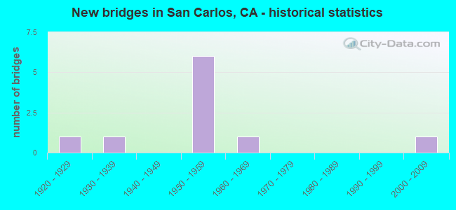
- New bridges - historical statistics
- 11920-1929
- 11930-1939
- 61950-1959
- 11960-1969
- 12000-2009


- Bridge Condition - Deck
- 33.3%Good
- 33.3%Satisfactory
- 33.3%Fair

- Bridge Condition - Superstructure
- 66.7%Good
- 33.3%Satisfactory

- Bridge Condition - Substructure
- 66.7%Good
- 33.3%Critical

- Bridge Condition - Channel
- 16.7%Excellent
- 16.7%Good
- 33.3%Satisfactory
- 16.7%Fair
- 16.7%Poor

- Bridge Condition - Culverts
- 75.0%Good
- 25.0%Fair
Find on map >> Show street view
Structure Number: 35 0037, Location: 04-SM-101-8.40 (Lat: 37.513494, Lng: -122.256322), Route carried "on" structure: County highway D003, Year Built: 1954, Year Reconstructed: 1987, Status: Open, Structure Length: 8.93m (29.30ft), Average Daily Traffic: 201,000 (year 2000), Truck Traffic: 7%, Average Future Daily Traffic: 399,464 (year 2041), Design Load: HS 20, Features Intersected: US HIGHWAY 101, Facility Carried by Structure: HOLLY STREET
Minimum Vertical Clearance: 30+ m (98+ ft), Kilometerpoint: 0.000, Lanes on structure: 6, Lanes under structure: 12, Base Highway Network: Yes, Owner: State Highway Agency, Approaching Roadway Width: 28.3m (92.8ft), Skew: 21 degrees, Material/Design: Steel continuous, Design/Construction: Stringer/Multi-beam, Number Of Spans In Main Unit: 4, Length of Maximum Span: 21.9m (71.9ft), Curb or Sidewalk Widths: Left: 0.2m (0.7ft), Right: 1.5m (4.9ft), Curb-To-Curb Width: 26.8m (87.9ft), Out-to-Out Width: 30.7m (100.7ft)
Condition: Deck: Satisfactory, Superstructure: Satisfactory, Substructure: Good, Operating Rating: 33.4 metric tons, Method Used To Determine Operating Rating: Load and Resistance Factor Rating (LRFR) rating reported by rating factor(RF) method using HL-93 loadings, Inventory Rating: 25.9 metric tons, Method Used To Determine Inventory Rating: Load and Resistance Factor Rating (LRFR) rating reported by rating factor(RF) method using HL-93 loadings, Structural Evaluation: Equal to present minimum criteria, Deck Geometry: Better than present minimum criteria, Underclear: Meets minimum limits, Approach Roadway Alignment: Equal to present desirable criteria, Designated Inspection Frequency: Every 24 months, Other Special Inspection Frequency: Every 48 months, Inspection Date: August 2021, Other Special Inspection Date: March 2018, Deck Structure Type: Concrete Cast-file-Place
Find on map >> Show street view
Structure Number: 35 0051, Location: 04-SM-001-5.73 (Lat: 37.165981, Lng: -122.360769), Route carried "on" structure: State highway 1, Year Built: 1958, Status: Open, Structure Length: 3.17m (10.40ft), Average Daily Traffic: 4,400 (year 2009), Average Future Daily Traffic: 6,100 (year 2037), Design Load: HS 20, Features Intersected: GAZOS CREEK
Minimum Vertical Clearance: 30+ m (98+ ft), Kilometerpoint: 5.730, Lanes on structure: 2, Base Highway Network: Yes (, Subroute: 1), Owner: State Highway Agency, Approaching Roadway Width: 12.2m (40.0ft), Skew: 1 degrees, Material/Design: Concrete continuous, Design/Construction: Tee Beam, Number Of Spans In Main Unit: 3, Length of Maximum Span: 12.2m (40.0ft), Curb-To-Curb Width: 12.8m (42.0ft), Out-to-Out Width: 13.0m (42.7ft)
Condition: Deck: Good, Superstructure: Good, Substructure: Good, Channel: Good, Operating Rating: 51.5 metric tons, Method Used To Determine Operating Rating: Load Factor (LF), Inventory Rating: 30.1 metric tons, Method Used To Determine Inventory Rating: Load Factor (LF), Structural Evaluation: Better than present minimum criteria, Deck Geometry: Equal to present minimum criteria, Waterway Adequacy: Superior to present desirable criteria, Approach Roadway Alignment: Equal to present desirable criteria, Designated Inspection Frequency: Every 24 months, Inspection Date: October 2020, Deck Structure Type: Concrete Cast-file-Place, Wearing Surface/Protective System: Wearing Surface: Bituminous
Find on map >> Show street view
Structure Number: 35 0056, Location: 04-SM-101-7.66-SCAR (Lat: 37.506050, Lng: -122.246850), Route carried "on" structure: US 101, Year Built: 2001, Status: Open, Structure Length: 1.25m (4.10ft), Average Daily Traffic: 195,000 (year 2009), Truck Traffic: 5%, Average Future Daily Traffic: 257,837 (year 2041), Features Intersected: PULGAS CREEK
Minimum Vertical Clearance: 30+ m (98+ ft), Kilometerpoint: 7.660, Lanes on structure: 10, Base Highway Network: Yes (Inventory Route: 1, Subroute: 1), Owner: State Highway Agency, Approaching Roadway Width: 38.4m (126.0ft), Skew: 30 degrees, Material/Design: Concrete continuous, Design/Construction: Culvert, Number Of Spans In Main Unit: 3, Length of Maximum Span: 3.7m (12.1ft)
Condition: Channel: Excellent, Culverts: Good, Operating Rating: 54.1 metric tons, Method Used To Determine Operating Rating: Field evaluation and documented engineering judgment, Inventory Rating: 32.4 metric tons, Method Used To Determine Inventory Rating: Field evaluation and documented engineering judgment, Structural Evaluation: Better than present minimum criteria, Waterway Adequacy: Equal to present desirable criteria, Approach Roadway Alignment: Equal to present desirable criteria, Designated Inspection Frequency: Every 48 months, Inspection Date: August 2019
Find on map >> Show street view
Structure Number: 35C0041, Location: 0.2 MI N CANYON RD (Lat: 37.215903, Lng: -122.349700), Route carried "on" structure: County highway , Year Built: 1963, Status: Open, Structure Length: 3.57m (11.71ft), Average Daily Traffic: 193 (year 2014), Truck Traffic: 9%, Average Future Daily Traffic: 500 (year 2037), Design Load: HS 20, Features Intersected: BUTANO CREEK, Facility Carried by Structure: CLOVERDALE RD
Minimum Vertical Clearance: 30+ m (98+ ft), Kilometerpoint: 0.000, Lanes on structure: 2, Owner: County Highway Agency, Approaching Roadway Width: 10.4m (34.1ft), Material/Design: Concrete continuous, Design/Construction: Tee Beam, Number Of Spans In Main Unit: 3, Length of Maximum Span: 14.0m (45.9ft), Curb-To-Curb Width: 10.4m (34.1ft), Out-to-Out Width: 10.5m (34.4ft)
Condition: Deck: Fair, Superstructure: Good, Substructure: Critical, Channel: Fair, Operating Rating: 23.3 metric tons, Method Used To Determine Operating Rating: Load and Resistance Factor Rating (LRFR) rating reported by rating factor(RF) method using HL-93 loadings, Inventory Rating: 16.5 metric tons, Method Used To Determine Inventory Rating: Load and Resistance Factor Rating (LRFR) rating reported by rating factor(RF) method using HL-93 loadings, Structural Evaluation: High priority of replacement, Deck Geometry: Better than present minimum criteria, Waterway Adequacy: Equal to present minimum criteria, Approach Roadway Alignment: Equal to present minimum criteria, Length Of Structure Improvement: 3.57m (11.71ft), Designated Inspection Frequency: Every 24 months, Inspection Date: April 2020, Bridge Improvement Cost: $862,000, Roadway Improvement Cost: $172,000, Total Project Cost: $1,449,000 ( Estimate for 2017), Deck Structure Type: Concrete Cast-file-Place
Find on map >> Show street view
Structure Number: 35C0049, Location: NORTH OF 'G' ST (Lat: 37.498322, Lng: -122.241133), Route carried "on" structure: City street , Year Built: 1930, Status: Open, Structure Length: 1.10m (3.61ft), Average Daily Traffic: 8,612 (year 2018), Truck Traffic: 15%, Average Future Daily Traffic: 10,582 (year 2040), Features Intersected: CORDILLERAS CREEK, Facility Carried by Structure: INDUSTRIAL BLVD
Minimum Vertical Clearance: 30+ m (98+ ft), Kilometerpoint: 0.000, Lanes on structure: 4, Base Highway Network: Yes, Owner: City or Municipal Highway Agency, Approaching Roadway Width: 18.4m (60.4ft), Skew: 1 degrees, Material/Design: Concrete continuous, Design/Construction: Culvert, Number Of Spans In Main Unit: 3, Length of Maximum Span: 3.7m (12.1ft), Curb or Sidewalk Widths: Left: 2.7m (8.9ft), Right: 2.7m (8.9ft), Curb-To-Curb Width: 18.4m (60.4ft), Out-to-Out Width: 25.1m (82.3ft)
Condition: Channel: Poor, Culverts: Fair, Operating Rating: 27.2 metric tons, Method Used To Determine Operating Rating: Field evaluation and documented engineering judgment, Inventory Rating: 16.2 metric tons, Method Used To Determine Inventory Rating: Field evaluation and documented engineering judgment, Structural Evaluation: Meets minimum limits, Deck Geometry: Somewhat better than minimum adequacy, Waterway Adequacy: Equal to present desirable criteria, Approach Roadway Alignment: Equal to present desirable criteria, Designated Inspection Frequency: Every 24 months, Inspection Date: April 2020, Deck Structure Type: Concrete Cast-file-Place
Find on map >> Show street view
Structure Number: 35C0072, Location: SOUTH HARBOR BLVD (Lat: 37.520317, Lng: -122.266075), Route carried "on" structure: County highway , Year Built: 1950, Status: Open, Structure Length: 0.67m (2.20ft), Average Daily Traffic: 4,592 (year 2016), Truck Traffic: 9%, Average Future Daily Traffic: 10,582 (year 2040), Features Intersected: BELMONT CREEK, Facility Carried by Structure: INDUSTRIAL WAY
Minimum Vertical Clearance: 30+ m (98+ ft), Kilometerpoint: 0.000, Lanes on structure: 4, Owner: County Highway Agency, Approaching Roadway Width: 19.5m (64.0ft), Material/Design: Concrete continuous, Design/Construction: Culvert, Number Of Spans In Main Unit: 2, Length of Maximum Span: 3.4m (11.2ft), Curb or Sidewalk Widths: Left: 1.6m (5.2ft), Right: 1.6m (5.2ft), Curb-To-Curb Width: 19.5m (64.0ft), Out-to-Out Width: 23.3m (76.4ft)
Condition: Channel: Satisfactory, Culverts: Good, Operating Rating: 40.5 metric tons, Method Used To Determine Operating Rating: Field evaluation and documented engineering judgment, Inventory Rating: 24.3 metric tons, Method Used To Determine Inventory Rating: Field evaluation and documented engineering judgment, Structural Evaluation: Equal to present minimum criteria, Deck Geometry: Better than present minimum criteria, Waterway Adequacy: Equal to present desirable criteria, Approach Roadway Alignment: Equal to present desirable criteria, Designated Inspection Frequency: Every 24 months, Inspection Date: April 2020, Deck Structure Type: Concrete Cast-file-Place, Wearing Surface/Protective System: Wearing Surface: Bituminous
Find on map >> Show street view
Structure Number: 35C0083, Location: SOUTH COMMERCIAL ST (Lat: 37.501653, Lng: -122.252511), Route carried "on" structure: City street , Year Built: 1920, Status: Open, Structure Length: 1.30m (4.27ft), Average Daily Traffic: 7,000 (year 2018), Truck Traffic: 10%, Average Future Daily Traffic: 16,033 (year 2040), Features Intersected: PULGAS CREEK, Facility Carried by Structure: OLD COUNTY RD
Minimum Vertical Clearance: 30+ m (98+ ft), Kilometerpoint: 0.000, Lanes on structure: 2, Owner: City or Municipal Highway Agency, Approaching Roadway Width: 11.3m (37.1ft), Material/Design: Concrete continuous, Design/Construction: Culvert, Number Of Spans In Main Unit: 4, Length of Maximum Span: 3.7m (12.1ft), Curb or Sidewalk Widths: Left: 0.0m, Right: 1.7m (5.6ft), Curb-To-Curb Width: 11.6m (38.1ft), Out-to-Out Width: 12.2m (40.0ft)
Condition: Channel: Satisfactory, Culverts: Good, Operating Rating: 27.2 metric tons, Method Used To Determine Operating Rating: Field evaluation and documented engineering judgment, Inventory Rating: 16.2 metric tons, Method Used To Determine Inventory Rating: Field evaluation and documented engineering judgment, Structural Evaluation: Meets minimum limits, Deck Geometry: Somewhat better than minimum adequacy, Waterway Adequacy: Equal to present desirable criteria, Approach Roadway Alignment: Equal to present desirable criteria, Designated Inspection Frequency: Every 24 months, Inspection Date: April 2020, Deck Structure Type: Concrete Cast-file-Place, Wearing Surface/Protective System: Wearing Surface: Bituminous
Find on map >> Show street view
Structure Number: 35 0037, Location: 04-SM-101-8.40 (Lat: 37.513494, Lng: -122.256322), Route carried "under" structure: Ramp US 101, Year Built: 1954, Structure Length: 0. m, Average Daily Traffic: 20,000 (year 2005), Truck Traffic: 2%, Features Intersected: US HIGHWAY 101, Facility Carried by Structure: HOLLY STREET
Minimum Vertical Clearance: 4.62m (15.16ft), Kilometerpoint: 8.400, Lanes on structure: 6, Lanes under structure: 2, Material/Design: Steel continuous, Design/Construction: Stringer/Multi-beam, Length of Maximum Span: 21.9m (71.9ft)
Find on map >> Show street view
Structure Number: 35 0037, Location: 04-SM-101-8.40 (Lat: 37.513494, Lng: -122.256322), Route carried "under" structure: Ramp US 101, Year Built: 1954, Structure Length: 0. m, Average Daily Traffic: 20,000 (year 2005), Truck Traffic: 2%, Features Intersected: US HIGHWAY 101, Facility Carried by Structure: HOLLY STREET
Minimum Vertical Clearance: 4.87m (15.98ft), Kilometerpoint: 8.400, Lanes on structure: 6, Lanes under structure: 2, Material/Design: Steel continuous, Design/Construction: Stringer/Multi-beam, Length of Maximum Span: 21.9m (71.9ft)
Find on map >> Show street view
Structure Number: 35 0037, Location: 04-SM-101-8.40 (Lat: 37.513494, Lng: -122.256322), Route carried "under" structure: US 101, Year Built: 1954, Structure Length: 0. m, Average Daily Traffic: 195,000 (year 2009), Truck Traffic: 5%, Features Intersected: US HIGHWAY 101, Facility Carried by Structure: HOLLY STREET
Minimum Vertical Clearance: 4.72m (15.49ft), Kilometerpoint: 8.400, Lanes on structure: 6, Lanes under structure: 8, Material/Design: Steel continuous, Design/Construction: Stringer/Multi-beam, Length of Maximum Span: 21.9m (71.9ft)