Bridge Statistics for Salmon Creek, Washington (WA)
Condition, Traffic, Stress, Structural Evaluation, Project Costs
- National Bridge Inventory (NBI) Statistics
- 36Number of bridges
- 725ft / 221mTotal length
- $178,343,000Total costs
- 1,022,240Total average daily traffic
- 76,708Total average daily truck traffic
- National Bridge Inventory (NBI) Registered Bridges for Salmon Creek
- No street view available for this location
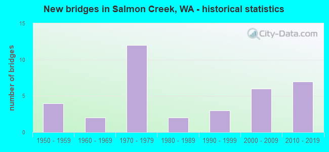
- New bridges - historical statistics
- 41950-1959
- 21960-1969
- 121970-1979
- 21980-1989
- 31990-1999
- 62000-2009
- 72010-2019


- Bridge Condition - Deck
- 25.0%Very good
- 54.2%Good
- 16.7%Satisfactory
- 4.2%Serious

- Bridge Condition - Superstructure
- 29.2%Very good
- 54.2%Good
- 16.7%Satisfactory

- Bridge Condition - Substructure
- 33.3%Very good
- 62.5%Good
- 4.2%Satisfactory

- Bridge Condition - Channel
- 69.2%Very good
- 15.4%Good
- 15.4%Satisfactory
Find on map >> Show street view
Structure Number: 5818A, Location: 5.3 N JCT SR 500 (Lat: 45.721969, Lng: -122.654936), Route carried "on" structure: Interstate 5, Year Built: 1959, Status: Open, Structure Length: 7.41m (24.31ft), Average Daily Traffic: 29,758 (year 2019), Truck Traffic: 8%, Average Future Daily Traffic: 43,089 (year 2039), Design Load: HS 20, Features Intersected: I-205 SB
Minimum Vertical Clearance: 30+ m (98+ ft), Kilometerpoint: 12.038, Lanes on structure: 2, Lanes under structure: 2, Base Highway Network: Yes, Owner: State Highway Agency, Approaching Roadway Width: 11.0m (36.1ft), Material/Design: Concrete continuous, Design/Construction: Box Beam or Girders - Multiple, Number Of Spans In Main Unit: 3, Length of Maximum Span: 29.3m (96.1ft), Curb-To-Curb Width: 9.6m (31.5ft), Out-to-Out Width: 10.5m (34.4ft)
Condition: Deck: Satisfactory, Superstructure: Good, Substructure: Good, Operating Rating: 63.5 metric tons, Method Used To Determine Operating Rating: Load Factor (LF), Inventory Rating: 37.2 metric tons, Method Used To Determine Inventory Rating: Load Factor (LF), Structural Evaluation: Better than present minimum criteria, Deck Geometry: Meets minimum limits, Underclear: Equal to present minimum criteria, Approach Roadway Alignment: Equal to present desirable criteria, Length Of Structure Improvement: 7.41m (24.31ft), Designated Inspection Frequency: Every 24 months, Inspection Date: November 2021, Bridge Improvement Cost: $1,847,000, Roadway Improvement Cost: $369,000, Total Project Cost: $3,694,000 ( Estimate for 2014), Deck Structure Type: Concrete Cast-file-Place, Wearing Surface/Protective System: Wearing Surface: Bituminous, Membrane: Preformed Fabric
Find on map >> Show street view
Structure Number: 5818B, Location: 5.3 N JCT SR 500 (Lat: 45.721917, Lng: -122.655194), Route carried "on" structure: Interstate 5, Year Built: 1959, Status: Open, Structure Length: 7.41m (24.31ft), Average Daily Traffic: 29,758 (year 2019), Truck Traffic: 8%, Average Future Daily Traffic: 43,089 (year 2039), Design Load: HS 20, Features Intersected: I-205 SB
Minimum Vertical Clearance: 30+ m (98+ ft), Kilometerpoint: 12.054, Lanes on structure: 2, Lanes under structure: 2, Base Highway Network: Yes, Owner: State Highway Agency, Approaching Roadway Width: 11.6m (38.1ft), Material/Design: Concrete continuous, Design/Construction: Box Beam or Girders - Multiple, Number Of Spans In Main Unit: 3, Length of Maximum Span: 27.7m (90.9ft), Curb-To-Curb Width: 9.6m (31.5ft), Out-to-Out Width: 10.5m (34.4ft)
Condition: Deck: Satisfactory, Superstructure: Satisfactory, Substructure: Good, Operating Rating: 63.5 metric tons, Method Used To Determine Operating Rating: Load Factor (LF), Inventory Rating: 37.2 metric tons, Method Used To Determine Inventory Rating: Load Factor (LF), Structural Evaluation: Equal to present minimum criteria, Deck Geometry: Meets minimum limits, Underclear: Equal to present minimum criteria, Approach Roadway Alignment: Equal to present desirable criteria, Length Of Structure Improvement: 7.41m (24.31ft), Designated Inspection Frequency: Every 24 months, Inspection Date: November 2021, Bridge Improvement Cost: $1,944,000, Roadway Improvement Cost: $389,000, Total Project Cost: $3,888,000 ( Estimate for 2014), Deck Structure Type: Concrete Cast-file-Place, Wearing Surface/Protective System: Wearing Surface: Bituminous, Membrane: Preformed Fabric
Find on map >> Show street view
Structure Number: 9106A, Location: 4.7 N JCT SR 500 (Lat: 45.707389, Lng: -122.632944), Route carried "on" structure: County highway , Year Built: 1972, Status: Open, Structure Length: 11.70m (38.39ft), Average Daily Traffic: 6,173 (year 2002), Truck Traffic: 15%, Average Future Daily Traffic: 11,210 (year 2036), Design Load: HS 20+Mod, Features Intersected: I-205, Facility Carried by Structure: NE 119TH ST
Minimum Vertical Clearance: 30+ m (98+ ft), Kilometerpoint: 0.660, Lanes on structure: 2, Lanes under structure: 4, Owner: State Highway Agency, Approaching Roadway Width: 13.4m (44.0ft), Skew: 4 degrees, Material/Design: Concrete continuous, Design/Construction: Box Beam or Girders - Multiple, Number Of Spans In Main Unit: 4, Length of Maximum Span: 39.6m (129.9ft), Curb or Sidewalk Widths: Left: 0.2m (0.7ft), Right: 0.2m (0.7ft), Curb-To-Curb Width: 13.4m (44.0ft), Out-to-Out Width: 14.3m (46.9ft)
Condition: Deck: Good, Superstructure: Good, Substructure: Good, Operating Rating: 21.1 metric tons, Method Used To Determine Operating Rating: Load and Resistance Factor Rating (LRFR) rating reported by rating factor(RF) method using HL-93 loadings, Inventory Rating: 16.2 metric tons, Method Used To Determine Inventory Rating: Load and Resistance Factor Rating (LRFR) rating reported by rating factor(RF) method using HL-93 loadings, Structural Evaluation: Meets minimum limits, Deck Geometry: Equal to present minimum criteria, Underclear: Better than present minimum criteria, Approach Roadway Alignment: Equal to present desirable criteria, Length Of Structure Improvement: 11.70m (38.39ft), Designated Inspection Frequency: Every 24 months, Inspection Date: October 2021, Bridge Improvement Cost: $3,533,000, Roadway Improvement Cost: $707,000, Total Project Cost: $7,066,000 ( Estimate for 2014), Deck Structure Type: Concrete Cast-file-Place, Wearing Surface/Protective System: Wearing Surface: Monolithic Concrete
Find on map >> Show street view
Structure Number: 9106B, Location: 5.8 N JCT SR 500 (Lat: 45.718028, Lng: -122.650000), Route carried "on" structure: County highway , Year Built: 1972, Status: Open, Structure Length: 12.13m (39.80ft), Average Daily Traffic: 21,340 (year 2012), Truck Traffic: 15%, Design Load: HS 20+Mod, Features Intersected: I-205, Facility Carried by Structure: NE 134TH ST
Minimum Vertical Clearance: 30+ m (98+ ft), Kilometerpoint: 0.064, Lanes on structure: 5, Lanes under structure: 4, Owner: State Highway Agency, Approaching Roadway Width: 18.0m (59.1ft), Skew: 4 degrees, Material/Design: Concrete continuous, Design/Construction: Box Beam or Girders - Multiple, Number Of Spans In Main Unit: 4, Length of Maximum Span: 39.9m (130.9ft), Curb or Sidewalk Widths: Left: 1.8m (5.9ft), Right: 0.2m (0.7ft), Curb-To-Curb Width: 18.0m (59.1ft), Out-to-Out Width: 20.6m (67.6ft)
Condition: Deck: Good, Superstructure: Satisfactory, Substructure: Good, Operating Rating: 74.4 metric tons, Method Used To Determine Operating Rating: Load Factor (LF), Inventory Rating: 44.4 metric tons, Method Used To Determine Inventory Rating: Load Factor (LF), Structural Evaluation: Equal to present minimum criteria, Deck Geometry: High priority of replacement, Underclear: Equal to present minimum criteria, Approach Roadway Alignment: Equal to present desirable criteria, Length Of Structure Improvement: 12.13m (39.80ft), Designated Inspection Frequency: Every 24 months, Inspection Date: October 2021, Bridge Improvement Cost: $4,856,000, Roadway Improvement Cost: $971,000, Total Project Cost: $9,711,000 ( Estimate for 2014), Deck Structure Type: Concrete Cast-file-Place, Wearing Surface/Protective System: Wearing Surface: Monolithic Concrete
Find on map >> Show street view
Structure Number: 9122B, Location: 3.9 N JCT SR 500 (Lat: 45.699000, Lng: -122.620472), Route carried "on" structure: County highway , Year Built: 1971, Status: Open, Structure Length: 7.56m (24.80ft), Average Daily Traffic: 7,397 (year 2012), Truck Traffic: 15%, Average Future Daily Traffic: 8,285 (year 2032), Design Load: HS 20+Mod, Features Intersected: I-205, Facility Carried by Structure: NE 50TH AVE
Minimum Vertical Clearance: 30+ m (98+ ft), Kilometerpoint: 1.014, Lanes on structure: 2, Lanes under structure: 4, Owner: State Highway Agency, Approaching Roadway Width: 13.4m (44.0ft), Skew: 1 degrees, Material/Design: Prestressed concrete continuous, Design/Construction: Box Beam or Girders - Multiple, Number Of Spans In Main Unit: 2, Length of Maximum Span: 36.9m (121.1ft), Curb or Sidewalk Widths: Left: 0.2m (0.7ft), Right: 0.2m (0.7ft), Curb-To-Curb Width: 13.4m (44.0ft), Out-to-Out Width: 14.4m (47.2ft)
Condition: Deck: Good, Superstructure: Good, Substructure: Good, Operating Rating: 88.9 metric tons, Method Used To Determine Operating Rating: Load Factor (LF), Inventory Rating: 52.6 metric tons, Method Used To Determine Inventory Rating: Load Factor (LF), Structural Evaluation: Better than present minimum criteria, Deck Geometry: Equal to present minimum criteria, Underclear: Better than present minimum criteria, Approach Roadway Alignment: Equal to present desirable criteria, Length Of Structure Improvement: 7.56m (24.80ft), Designated Inspection Frequency: Every 24 months, Inspection Date: October 2021, Bridge Improvement Cost: $2,282,000, Roadway Improvement Cost: $456,000, Total Project Cost: $4,563,000 ( Estimate for 2014), Deck Structure Type: Concrete Cast-file-Place, Wearing Surface/Protective System: Wearing Surface: Monolithic Concrete
Find on map >> Show street view
Structure Number: 9241H, Location: 5.1 N JCT SR 500 (Lat: 45.710972, Lng: -122.637750), Route carried "on" structure: Interstate 205, Year Built: 1973, Status: Open, Structure Length: 8.96m (29.40ft), Average Daily Traffic: 37,214 (year 2019), Truck Traffic: 7%, Average Future Daily Traffic: 53,885 (year 2039), Design Load: HS 20+Mod, Features Intersected: SALMON CR/SALMON CR AVE
Minimum Vertical Clearance: 30+ m (98+ ft), Kilometerpoint: 57.952, Lanes on structure: 2, Lanes under structure: 2, Base Highway Network: Yes, Owner: State Highway Agency, Approaching Roadway Width: 11.6m (38.1ft), Skew: 2 degrees, Material/Design: Prestressed concrete continuous, Design/Construction: Stringer/Multi-beam, Number Of Spans In Main Unit: 3, Length of Maximum Span: 32.6m (107.0ft), Curb or Sidewalk Widths: Left: 0.2m (0.7ft), Right: 0.2m (0.7ft), Curb-To-Curb Width: 11.6m (38.1ft), Out-to-Out Width: 12.5m (41.0ft)
Condition: Deck: Good, Superstructure: Good, Substructure: Good, Channel: Very good, Operating Rating: 53.5 metric tons, Method Used To Determine Operating Rating: Load Factor (LF), Inventory Rating: 31.7 metric tons, Method Used To Determine Inventory Rating: Load Factor (LF), Structural Evaluation: Better than present minimum criteria, Deck Geometry: Equal to present minimum criteria, Underclear: Superior to present desirable criteria, Waterway Adequacy: Equal to present desirable criteria, Approach Roadway Alignment: Equal to present desirable criteria, Length Of Structure Improvement: 8.96m (29.40ft), Designated Inspection Frequency: Every 48 months, Inspection Date: April 2018, Bridge Improvement Cost: $2,352,000, Roadway Improvement Cost: $470,000, Total Project Cost: $4,704,000 ( Estimate for 2014), Deck Structure Type: Concrete Cast-file-Place, Wearing Surface/Protective System: Wearing Surface: Low Slump Concrete
Find on map >> Show street view
Structure Number: 9241I, Location: 5.1 N JCT SR 500 (Lat: 45.710611, Lng: -122.637972), Route carried "on" structure: Interstate 205, Year Built: 1973, Status: Open, Structure Length: 8.78m (28.81ft), Average Daily Traffic: 37,214 (year 2019), Truck Traffic: 7%, Average Future Daily Traffic: 53,885 (year 2039), Design Load: HS 20+Mod, Features Intersected: SALMON CR & AVE
Minimum Vertical Clearance: 30+ m (98+ ft), Kilometerpoint: 57.936, Lanes on structure: 2, Lanes under structure: 2, Base Highway Network: Yes, Owner: State Highway Agency, Approaching Roadway Width: 12.8m (42.0ft), Skew: 2 degrees, Material/Design: Prestressed concrete continuous, Design/Construction: Stringer/Multi-beam, Number Of Spans In Main Unit: 3, Length of Maximum Span: 32.6m (107.0ft), Curb or Sidewalk Widths: Left: 0.2m (0.7ft), Right: 0.2m (0.7ft), Curb-To-Curb Width: 11.6m (38.1ft), Out-to-Out Width: 12.5m (41.0ft)
Condition: Deck: Good, Superstructure: Good, Substructure: Good, Channel: Very good, Operating Rating: 53.5 metric tons, Method Used To Determine Operating Rating: Load Factor (LF), Inventory Rating: 31.7 metric tons, Method Used To Determine Inventory Rating: Load Factor (LF), Structural Evaluation: Better than present minimum criteria, Deck Geometry: Equal to present minimum criteria, Underclear: Superior to present desirable criteria, Waterway Adequacy: Equal to present desirable criteria, Approach Roadway Alignment: Equal to present desirable criteria, Length Of Structure Improvement: 8.78m (28.81ft), Designated Inspection Frequency: Every 48 months, Inspection Date: April 2018, Bridge Improvement Cost: $2,534,000, Roadway Improvement Cost: $507,000, Total Project Cost: $5,069,000 ( Estimate for 2014), Deck Structure Type: Concrete Cast-file-Place, Wearing Surface/Protective System: Wearing Surface: Low Slump Concrete
Find on map >> Show street view
Structure Number: 9241J, Location: 6.0 N JCT SR 500 (Lat: 45.719000, Lng: -122.651361), Route carried "on" structure: County highway , Year Built: 1974, Year Reconstructed: 2005, Status: Open, Structure Length: 11.92m (39.11ft), Average Daily Traffic: 16,383 (year 2017), Truck Traffic: 10%, Average Future Daily Traffic: 23,867 (year 2036), Design Load: HS 20+Mod, Features Intersected: I-205, Facility Carried by Structure: NE 20TH AVE
Minimum Vertical Clearance: 30+ m (98+ ft), Kilometerpoint: 0.080, Lanes on structure: 5, Lanes under structure: 4, Owner: State Highway Agency, Approaching Roadway Width: 23.5m (77.1ft), Skew: 4 degrees, Material/Design: Concrete continuous, Design/Construction: Box Beam or Girders - Multiple, Number Of Spans In Main Unit: 4, Length of Maximum Span: 41.1m (134.8ft), Curb or Sidewalk Widths: Left: 1.8m (5.9ft), Right: 1.8m (5.9ft), Curb-To-Curb Width: 23.3m (76.4ft), Out-to-Out Width: 30.0m (98.4ft)
Condition: Deck: Good, Superstructure: Good, Substructure: Good, Operating Rating: 71.7 metric tons, Method Used To Determine Operating Rating: Load Factor (LF), Inventory Rating: 42.6 metric tons, Method Used To Determine Inventory Rating: Load Factor (LF), Structural Evaluation: Better than present minimum criteria, Deck Geometry: Better than present minimum criteria, Underclear: Meets minimum limits, Approach Roadway Alignment: Equal to present desirable criteria, Length Of Structure Improvement: 11.92m (39.11ft), Designated Inspection Frequency: Every 24 months, Inspection Date: October 2021, Bridge Improvement Cost: $6,178,000, Roadway Improvement Cost: $1,236,000, Total Project Cost: $12,356,000 ( Estimate for 2014), Deck Structure Type: Concrete Cast-file-Place, Wearing Surface/Protective System: Wearing Surface: Monolithic Concrete
Find on map >> Show street view
Structure Number: 14323A, Location: 5.0 N JCT SR 500 (Lat: 45.718250, Lng: -122.655361), Route carried "on" structure: County highway , Year Built: 1994, Status: Open, Structure Length: 6.46m (21.19ft), Average Daily Traffic: 28,562 (year 2012), Truck Traffic: 3%, Average Future Daily Traffic: 45,014 (year 2036), Design Load: HS 25 or greater, Features Intersected: I-5, Facility Carried by Structure: NE 134TH ST
Minimum Vertical Clearance: 30+ m (98+ ft), Kilometerpoint: 0.080, Lanes on structure: 5, Lanes under structure: 6, Owner: State Highway Agency, Approaching Roadway Width: 20.4m (66.9ft), Skew: 1 degrees, Material/Design: Prestressed concrete continuous, Design/Construction: Box Beam or Girders - Multiple, Number Of Spans In Main Unit: 2, Length of Maximum Span: 31.7m (104.0ft), Curb or Sidewalk Widths: Left: 1.8m (5.9ft), Right: 1.8m (5.9ft), Curb-To-Curb Width: 20.4m (66.9ft), Out-to-Out Width: 24.6m (80.7ft)
Condition: Deck: Good, Superstructure: Good, Substructure: Good, Operating Rating: 49.0 metric tons, Method Used To Determine Operating Rating: Load Factor (LF), Inventory Rating: 30.8 metric tons, Method Used To Determine Inventory Rating: Load Factor (LF), Structural Evaluation: Better than present minimum criteria, Deck Geometry: Somewhat better than minimum adequacy, Underclear: Meets minimum limits, Approach Roadway Alignment: Equal to present desirable criteria, Length Of Structure Improvement: 6.46m (21.19ft), Designated Inspection Frequency: Every 24 months, Inspection Date: November 2021, Bridge Improvement Cost: $2,926,000, Roadway Improvement Cost: $585,000, Total Project Cost: $5,851,000 ( Estimate for 2014), Deck Structure Type: Concrete Cast-file-Place, Wearing Surface/Protective System: Wearing Surface: Monolithic Concrete, Deck Protection: Epoxy Coated Reinforcing
Find on map >> Show street view
Structure Number: 14329A, Location: 3.2 N JCT SR 500 (Lat: 45.693472, Lng: -122.661306), Route carried "on" structure: Interstate 5, Year Built: 1996, Status: Open, Structure Length: 10.06m (33.01ft), Average Daily Traffic: 72,384 (year 2019), Truck Traffic: 8%, Average Future Daily Traffic: 104,812 (year 2039), Design Load: HS 25 or greater, Features Intersected: NE 99TH ST
Minimum Vertical Clearance: 30+ m (98+ ft), Kilometerpoint: 8.674, Lanes on structure: 6, Lanes under structure: 8, Base Highway Network: Yes, Owner: State Highway Agency, Approaching Roadway Width: 34.4m (112.9ft), Skew: 32 degrees, Material/Design: Prestressed concrete continuous, Design/Construction: Box Beam or Girders - Multiple, Number Of Spans In Main Unit: 3, Length of Maximum Span: 61.0m (200.1ft), Curb-To-Curb Width: 35.1m (115.2ft), Out-to-Out Width: 36.0m (118.1ft)
Condition: Deck: Satisfactory, Superstructure: Satisfactory, Substructure: Good, Operating Rating: 89.8 metric tons, Method Used To Determine Operating Rating: Load Factor (LF), Inventory Rating: 89.8 metric tons, Method Used To Determine Inventory Rating: Load Factor (LF), Structural Evaluation: Equal to present minimum criteria, Deck Geometry: Superior to present desirable criteria, Underclear: Meets minimum limits, Approach Roadway Alignment: Equal to present desirable criteria, Length Of Structure Improvement: 10.06m (33.01ft), Designated Inspection Frequency: Every 24 months, Inspection Date: July 2020, Bridge Improvement Cost: $7,590,000, Roadway Improvement Cost: $1,518,000, Total Project Cost: $15,180,000 ( Estimate for 2014), Deck Structure Type: Concrete Cast-file-Place, Wearing Surface/Protective System: Wearing Surface: Monolithic Concrete, Deck Protection: Epoxy Coated Reinforcing
Find on map >> Show street view
Structure Number: 16610A, Location: 4.1 N JCT SR 500 (Lat: 45.705306, Lng: -122.654694), Route carried "on" structure: Interstate 5, Year Built: 2005, Status: Open, Structure Length: 13.01m (42.68ft), Average Daily Traffic: 42,735 (year 2019), Truck Traffic: 8%, Average Future Daily Traffic: 61,880 (year 2039), Design Load: HL 93, Features Intersected: NE 117TH,SALMON CK, PATH
Minimum Vertical Clearance: 30+ m (98+ ft), Kilometerpoint: 10.171, Lanes on structure: 4, Lanes under structure: 2, Base Highway Network: Yes, Owner: State Highway Agency, Approaching Roadway Width: 20.7m (67.9ft), Material/Design: Prestressed concrete continuous, Design/Construction: Stringer/Multi-beam, Number Of Spans In Main Unit: 3, Length of Maximum Span: 47.2m (154.9ft), Curb-To-Curb Width: 20.8m (68.2ft), Out-to-Out Width: 21.6m (70.9ft)
Condition: Deck: Good, Superstructure: Very good, Substructure: Very good, Channel: Satisfactory, Operating Rating: 85.3 metric tons, Method Used To Determine Operating Rating: Load Factor (LF), Inventory Rating: 51.7 metric tons, Method Used To Determine Inventory Rating: Load Factor (LF), Structural Evaluation: Equal to present desirable criteria, Deck Geometry: Equal to present minimum criteria, Underclear: Better than present minimum criteria, Waterway Adequacy: Equal to present desirable criteria, Approach Roadway Alignment: Equal to present desirable criteria, Length Of Structure Improvement: 13.01m (42.68ft), Designated Inspection Frequency: Every 24 months, Inspection Date: Febuary 2021, Bridge Improvement Cost: $5,978,000, Roadway Improvement Cost: $1,196,000, Total Project Cost: $11,956,000 ( Estimate for 2014), Deck Structure Type: Concrete Cast-file-Place, Wearing Surface/Protective System: Wearing Surface: Monolithic Concrete, Deck Protection: Epoxy Coated Reinforcing
Find on map >> Show street view
Structure Number: 16610B, Location: 4.1 N JCT SR 500 (Lat: 45.705306, Lng: -122.655000), Route carried "on" structure: Interstate 5, Year Built: 2005, Status: Open, Structure Length: 13.01m (42.68ft), Average Daily Traffic: 42,735 (year 2019), Truck Traffic: 8%, Average Future Daily Traffic: 61,880 (year 2039), Design Load: HL 93, Features Intersected: NE 117TH, SALMON CK,PATH
Minimum Vertical Clearance: 30+ m (98+ ft), Kilometerpoint: 10.171, Lanes on structure: 4, Lanes under structure: 3, Base Highway Network: Yes, Owner: State Highway Agency, Approaching Roadway Width: 20.7m (67.9ft), Material/Design: Prestressed concrete continuous, Design/Construction: Stringer/Multi-beam, Number Of Spans In Main Unit: 3, Length of Maximum Span: 48.8m (160.1ft), Curb-To-Curb Width: 20.8m (68.2ft), Out-to-Out Width: 21.4m (70.2ft)
Condition: Deck: Good, Superstructure: Good, Substructure: Good, Channel: Satisfactory, Operating Rating: 69.8 metric tons, Method Used To Determine Operating Rating: Load Factor (LF), Inventory Rating: 41.7 metric tons, Method Used To Determine Inventory Rating: Load Factor (LF), Structural Evaluation: Better than present minimum criteria, Deck Geometry: Equal to present minimum criteria, Underclear: Equal to present minimum criteria, Waterway Adequacy: Equal to present desirable criteria, Approach Roadway Alignment: Equal to present desirable criteria, Length Of Structure Improvement: 13.01m (42.68ft), Designated Inspection Frequency: Every 24 months, Inspection Date: Febuary 2021, Bridge Improvement Cost: $5,978,000, Roadway Improvement Cost: $1,196,000, Total Project Cost: $11,956,000 ( Estimate for 2014), Deck Structure Type: Concrete Cast-file-Place, Wearing Surface/Protective System: Wearing Surface: Monolithic Concrete, Deck Protection: Epoxy Coated Reinforcing
Find on map >> Show street view
Structure Number: 16610C, Location: 4.7 N JCT SR 500 (Lat: 45.714517, Lng: -122.652817), Route carried "on" structure: County highway , Year Built: 2004, Status: Open, Structure Length: 5.30m (17.39ft), Average Daily Traffic: 4,574 (year 2004), Truck Traffic: 4%, Average Future Daily Traffic: 6,184 (year 2036), Design Load: HL 93, Features Intersected: I-5, Facility Carried by Structure: NE 129TH ST
Minimum Vertical Clearance: 30+ m (98+ ft), Kilometerpoint: 0.001, Lanes on structure: 2, Lanes under structure: 9, Owner: State Highway Agency, Approaching Roadway Width: 12.2m (40.0ft), Skew: 1 degrees, Material/Design: Prestressed concrete continuous, Design/Construction: Stringer/Multi-beam, Number Of Spans In Main Unit: 2, Length of Maximum Span: 26.8m (87.9ft), Curb or Sidewalk Widths: Left: 2.0m (6.6ft), Right: 2.0m (6.6ft), Curb-To-Curb Width: 12.2m (40.0ft), Out-to-Out Width: 16.7m (54.8ft)
Condition: Deck: Good, Superstructure: Good, Substructure: Good, Operating Rating: 82.5 metric tons, Method Used To Determine Operating Rating: Load Factor (LF), Inventory Rating: 49.9 metric tons, Method Used To Determine Inventory Rating: Load Factor (LF), Structural Evaluation: Better than present minimum criteria, Deck Geometry: Equal to present minimum criteria, Underclear: High priority of corrective action, Approach Roadway Alignment: Equal to present desirable criteria, Length Of Structure Improvement: 5.30m (17.39ft), Designated Inspection Frequency: Every 48 months, Inspection Date: July 2020, Bridge Improvement Cost: $1,462,000, Roadway Improvement Cost: $292,000, Total Project Cost: $2,923,000 ( Estimate for 2014), Deck Structure Type: Concrete Cast-file-Place, Wearing Surface/Protective System: Wearing Surface: Integral Concrete, Deck Protection: Epoxy Coated Reinforcing
Find on map >> Show street view
Structure Number: 18311A, Location: 5.3 N JCT SR 500 (Lat: 45.721583, Lng: -122.657278), Route carried "on" structure: City street 5, Year Built: 2014, Status: Open, Structure Length: 37.58m (123.29ft), Average Daily Traffic: 14,913 (year 2019), Truck Traffic: 3%, Average Future Daily Traffic: 21,594 (year 2039), Design Load: HL 93, Features Intersected: I-5 / I-205, Facility Carried by Structure: NE 139TH ST
Minimum Vertical Clearance: 30+ m (98+ ft), Kilometerpoint: 0.145, Lanes on structure: 4, Lanes under structure: 10, Owner: State Highway Agency, Approaching Roadway Width: 23.8m (78.1ft), Skew: 20 degrees, Material/Design: Prestressed concrete continuous, Design/Construction: Stringer/Multi-beam, Number Of Spans In Main Unit: 9, Length of Maximum Span: 48.8m (160.1ft), Curb or Sidewalk Widths: Left: 0.0m, Right: 2.6m (8.5ft), Curb-To-Curb Width: 23.6m (77.4ft), Out-to-Out Width: 33.3m (109.3ft)
Condition: Deck: Very good, Superstructure: Very good, Substructure: Very good, Operating Rating: 43.4 metric tons, Method Used To Determine Operating Rating: Load and Resistance Factor Rating (LRFR) rating reported by rating factor(RF) method using HL-93 loadings, Inventory Rating: 33.4 metric tons, Method Used To Determine Inventory Rating: Load and Resistance Factor Rating (LRFR) rating reported by rating factor(RF) method using HL-93 loadings, Structural Evaluation: Equal to present desirable criteria, Deck Geometry: Superior to present desirable criteria, Underclear: High priority of corrective action, Approach Roadway Alignment: Equal to present desirable criteria, Length Of Structure Improvement: 37.58m (123.29ft), Designated Inspection Frequency: Every 48 months, Inspection Date: September 2018, Bridge Improvement Cost: $19,728,000, Roadway Improvement Cost: $3,946,000, Total Project Cost: $39,456,000 ( Estimate for 2014), Deck Structure Type: Concrete Cast-file-Place, Wearing Surface/Protective System: Wearing Surface: Monolithic Concrete, Deck Protection: Epoxy Coated Reinforcing
Find on map >> Show street view
Structure Number: 18311B, Location: 5.3 N JCT SR 500 (Lat: 45.720750, Lng: -122.653972), Route carried "on" structure: Ramp Interstate 5, Year Built: 2014, Status: Open, Structure Length: 9.60m (31.50ft), Average Daily Traffic: 6,916 (year 2019), Truck Traffic: 5%, Average Future Daily Traffic: 10,014 (year 2039), Design Load: HL 93, Features Intersected: I-205 SB, Facility Carried by Structure: N-N RAMP
Minimum Vertical Clearance: 30+ m (98+ ft), Kilometerpoint: 0.435, Lanes on structure: 2, Lanes under structure: 3, Owner: State Highway Agency, Approaching Roadway Width: 9.1m (29.9ft), Material/Design: Prestressed concrete continuous, Design/Construction: Stringer/Multi-beam, Number Of Spans In Main Unit: 3, Length of Maximum Span: 45.7m (149.9ft), Curb-To-Curb Width: 12.2m (40.0ft), Out-to-Out Width: 13.1m (43.0ft)
Condition: Deck: Very good, Superstructure: Very good, Substructure: Very good, Operating Rating: 49.2 metric tons, Method Used To Determine Operating Rating: Load and Resistance Factor Rating (LRFR) rating reported by rating factor(RF) method using HL-93 loadings, Inventory Rating: 37.9 metric tons, Method Used To Determine Inventory Rating: Load and Resistance Factor Rating (LRFR) rating reported by rating factor(RF) method using HL-93 loadings, Structural Evaluation: Equal to present desirable criteria, Deck Geometry: Superior to present desirable criteria, Underclear: Equal to present minimum criteria, Approach Roadway Alignment: Equal to present desirable criteria, Length Of Structure Improvement: 9.60m (31.50ft), Designated Inspection Frequency: Every 48 months, Inspection Date: September 2018, Bridge Improvement Cost: $2,016,000, Roadway Improvement Cost: $403,000, Total Project Cost: $4,032,000 ( Estimate for 2014), Deck Structure Type: Concrete Cast-file-Place, Wearing Surface/Protective System: Wearing Surface: Monolithic Concrete, Deck Protection: Epoxy Coated Reinforcing
Find on map >> Show street view
Structure Number: 18311C, Location: 5.3 N JCT SR 500 (Lat: 45.721556, Lng: -122.656139), Route carried "on" structure: Ramp Interstate 5, Year Built: 2014, Status: Open, Structure Length: 13.23m (43.41ft), Average Daily Traffic: 5,928 (year 2019), Truck Traffic: 5%, Average Future Daily Traffic: 8,583 (year 2039), Design Load: HL 93, Features Intersected: NE 16TH AVE, Facility Carried by Structure: S-S RAMP
Minimum Vertical Clearance: 30+ m (98+ ft), Kilometerpoint: 0.016, Lanes on structure: 2, Lanes under structure: 2, Owner: State Highway Agency, Approaching Roadway Width: 11.3m (37.1ft), Material/Design: Prestressed concrete continuous, Design/Construction: Stringer/Multi-beam, Number Of Spans In Main Unit: 4, Length of Maximum Span: 45.7m (149.9ft), Curb-To-Curb Width: 11.3m (37.1ft), Out-to-Out Width: 12.8m (42.0ft)
Condition: Deck: Very good, Superstructure: Very good, Substructure: Very good, Operating Rating: 50.2 metric tons, Method Used To Determine Operating Rating: Load and Resistance Factor Rating (LRFR) rating reported by rating factor(RF) method using HL-93 loadings, Inventory Rating: 38.9 metric tons, Method Used To Determine Inventory Rating: Load and Resistance Factor Rating (LRFR) rating reported by rating factor(RF) method using HL-93 loadings, Structural Evaluation: Equal to present desirable criteria, Deck Geometry: Superior to present desirable criteria, Underclear: Superior to present desirable criteria, Approach Roadway Alignment: Equal to present desirable criteria, Length Of Structure Improvement: 13.23m (43.41ft), Designated Inspection Frequency: Every 48 months, Inspection Date: September 2018, Bridge Improvement Cost: $3,385,000, Roadway Improvement Cost: $677,000, Total Project Cost: $6,770,000 ( Estimate for 2014), Deck Structure Type: Concrete Cast-file-Place, Wearing Surface/Protective System: Wearing Surface: Monolithic Concrete, Deck Protection: Epoxy Coated Reinforcing
Find on map >> Show street view
Structure Number: 801, Location: 6 NE 0.9 East of N NE (Lat: 47.174408, Lng: -119.174258), Route carried "on" structure: County highway 94010, Year Built: 1989, Status: Open, Structure Length: 2.96m (9.71ft), Average Daily Traffic: 215 (year 2019), Truck Traffic: 27%, Average Future Daily Traffic: 325 (year 2041), Design Load: HS 20, Features Intersected: EAST LOW CANAL BLK 41, Facility Carried by Structure: 6 ROAD NE
Minimum Vertical Clearance: 30+ m (98+ ft), Kilometerpoint: 0.001, Lanes on structure: 2, Owner: County Highway Agency, Approaching Roadway Width: 8.5m (27.9ft), Skew: 1 degrees, Material/Design: Prestressed concrete, Design/Construction: Tee Beam, Number Of Spans In Main Unit: 1, Length of Maximum Span: 29.3m (96.1ft), Curb-To-Curb Width: 9.0m (29.5ft), Out-to-Out Width: 9.1m (29.9ft)
Condition: Deck: Very good, Superstructure: Good, Substructure: Very good, Channel: Very good, Operating Rating: 34.0 metric tons, Method Used To Determine Operating Rating: Load and Resistance Factor Rating (LRFR) rating reported by rating factor(RF) method using HL-93 loadings, Inventory Rating: 19.1 metric tons, Method Used To Determine Inventory Rating: Load and Resistance Factor Rating (LRFR) rating reported by rating factor(RF) method using HL-93 loadings, Structural Evaluation: Somewhat better than minimum adequacy, Deck Geometry: Equal to present minimum criteria, Waterway Adequacy: Equal to present desirable criteria, Approach Roadway Alignment: Equal to present desirable criteria, Length Of Structure Improvement: 2.96m (9.71ft), Designated Inspection Frequency: Every 24 months, Inspection Date: November 2020, Bridge Improvement Cost: $582,000, Roadway Improvement Cost: $116,000, Total Project Cost: $1,164,000 ( Estimate for 2014), Deck Structure Type: Other, Wearing Surface/Protective System: Wearing Surface: Integral Concrete
Find on map >> Show street view
Structure Number: 809, Location: 00.66 MI W SR24 (Lat: 46.796817, Lng: -119.190792), Route carried "on" structure: County highway 12241, Year Built: 1978, Status: Posted for load, Structure Length: 3.90m (12.80ft), Average Daily Traffic: 3,255 (year 2018), Truck Traffic: 3%, Average Future Daily Traffic: 4,052 (year 2039), Design Load: HS 20, Features Intersected: POTHOLES EAST CANAL, Facility Carried by Structure: BENCH RD
Minimum Vertical Clearance: 30+ m (98+ ft), Kilometerpoint: 0.001, Lanes on structure: 2, Owner: County Highway Agency, Approaching Roadway Width: 12.2m (40.0ft), Material/Design: Concrete continuous, Design/Construction: Stringer/Multi-beam, Number Of Spans In Main Unit: 1, Length of Maximum Span: 38.4m (126.0ft), Curb or Sidewalk Widths: Left: 1.6m (5.2ft), Right: 0.0m, Curb-To-Curb Width: 12.2m (40.0ft), Out-to-Out Width: 14.6m (47.9ft)
Condition: Deck: Good, Superstructure: Satisfactory, Substructure: Satisfactory, Channel: Good, Operating Rating: 49.6 metric tons, Method Used To Determine Operating Rating: Load and Resistance Factor Rating (LRFR) rating reported by rating factor(RF) method using HL-93 loadings, Inventory Rating: 21.1 metric tons, Method Used To Determine Inventory Rating: Load and Resistance Factor Rating (LRFR) rating reported by rating factor(RF) method using HL-93 loadings, Structural Evaluation: Somewhat better than minimum adequacy, Deck Geometry: Equal to present minimum criteria, Waterway Adequacy: Equal to present desirable criteria, Approach Roadway Alignment: Equal to present desirable criteria, Bridge Posting: Required (Relationship of Operating Rating to Maximum Legal Load: 10.0 - 19.9% below), Length Of Structure Improvement: 4.21m (13.81ft), Designated Inspection Frequency: Every 24 months, Inspection Date: November 2020, Bridge Improvement Cost: $2,098,000, Roadway Improvement Cost: $420,000, Total Project Cost: $4,195,000 ( Estimate for 2014), Deck Structure Type: Other, Wearing Surface/Protective System: Wearing Surface: Bituminous
Find on map >> Show street view
Structure Number: 815, Location: 24.15 MI SW SR 195 (Lat: 46.535433, Lng: -117.245300), Route carried "on" structure: County highway 90000, Year Built: 1972, Status: Open, Structure Length: 1.83m (6.00ft), Average Daily Traffic: 117 (year 2020), Truck Traffic: 25%, Average Future Daily Traffic: 117 (year 2039), Design Load: HS 20, Features Intersected: UNNAMED DRAINAGE, Facility Carried by Structure: WAWAWAI/9000
Minimum Vertical Clearance: 30+ m (98+ ft), Kilometerpoint: 0.001, Lanes on structure: 2, Owner: County Highway Agency, Approaching Roadway Width: 8.5m (27.9ft), Material/Design: Prestressed concrete, Design/Construction: Stringer/Multi-beam, Number Of Spans In Main Unit: 1, Length of Maximum Span: 18.0m (59.1ft), Curb-To-Curb Width: 7.9m (25.9ft), Out-to-Out Width: 8.3m (27.2ft)
Condition: Deck: Good, Superstructure: Good, Substructure: Good, Channel: Very good, Operating Rating: 46.7 metric tons, Method Used To Determine Operating Rating: Load and Resistance Factor Rating (LRFR) rating reported by rating factor(RF) method using HL-93 loadings, Inventory Rating: 32.4 metric tons, Method Used To Determine Inventory Rating: Load and Resistance Factor Rating (LRFR) rating reported by rating factor(RF) method using HL-93 loadings, Structural Evaluation: Better than present minimum criteria, Deck Geometry: Somewhat better than minimum adequacy, Waterway Adequacy: Equal to present desirable criteria, Approach Roadway Alignment: Equal to present desirable criteria, Length Of Structure Improvement: 2.13m (6.99ft), Designated Inspection Frequency: Every 24 months, Inspection Date: December 2020, Bridge Improvement Cost: $1,064,000, Roadway Improvement Cost: $213,000, Total Project Cost: $2,128,000 ( Estimate for 2014), Deck Structure Type: Other, Wearing Surface/Protective System: Wearing Surface: Bituminous
Find on map >> Show street view
Structure Number: 82, Location: 0.34 N SR 2 (Lat: 47.658333, Lng: -118.161667), Route carried "on" structure: County highway 54710, Year Built: 1968, Status: Open, Structure Length: 2.44m (8.01ft), Average Daily Traffic: 110 (year 2021), Truck Traffic: 40%, Average Future Daily Traffic: 150 (year 2042), Design Load: HS 20, Features Intersected: COTTONWOOD CREEK
Minimum Vertical Clearance: 30+ m (98+ ft), Kilometerpoint: 0.001, Lanes on structure: 2, Owner: County Highway Agency, Approaching Roadway Width: 7.9m (25.9ft), Material/Design: Concrete, Design/Construction: Box Beam or Girders - Multiple, Number Of Spans In Main Unit: 1, Length of Maximum Span: 19.5m (64.0ft), Curb-To-Curb Width: 9.1m (29.9ft), Out-to-Out Width: 10.4m (34.1ft)
Condition: Deck: Very good, Superstructure: Very good, Substructure: Very good, Channel: Very good, Operating Rating: 53.5 metric tons, Method Used To Determine Operating Rating: Load and Resistance Factor Rating (LRFR) rating reported by rating factor(RF) method using HL-93 loadings, Inventory Rating: 34.3 metric tons, Method Used To Determine Inventory Rating: Load and Resistance Factor Rating (LRFR) rating reported by rating factor(RF) method using HL-93 loadings, Structural Evaluation: Equal to present desirable criteria, Deck Geometry: Equal to present minimum criteria, Waterway Adequacy: Equal to present desirable criteria, Approach Roadway Alignment: Equal to present desirable criteria, Designated Inspection Frequency: Every 24 months, Inspection Date: November 2021, Deck Structure Type: Other, Wearing Surface/Protective System: Wearing Surface: Bituminous
Find on map >> Show street view
Structure Number: 827, Location: 1.9 N JCT US 101 (Lat: 48.092000, Lng: -124.265361), Route carried "on" structure: State highway 113, Year Built: 1966, Status: Open, Structure Length: 2.44m (8.01ft), Average Daily Traffic: 1,204 (year 2019), Truck Traffic: 18%, Average Future Daily Traffic: 1,507 (year 2039), Design Load: HS 20, Features Intersected: BEAVER CREEK
Minimum Vertical Clearance: 30+ m (98+ ft), Kilometerpoint: 3.009, Lanes on structure: 2, Owner: State Highway Agency, Approaching Roadway Width: 10.4m (34.1ft), Skew: 2 degrees, Material/Design: Concrete continuous, Design/Construction: Tee Beam, Number Of Spans In Main Unit: 3, Length of Maximum Span: 15.2m (49.9ft), Curb or Sidewalk Widths: Left: 0.4m (1.3ft), Right: 0.4m (1.3ft), Curb-To-Curb Width: 8.0m (26.2ft), Out-to-Out Width: 9.3m (30.5ft)
Condition: Deck: Serious, Superstructure: Good, Substructure: Good, Channel: Good, Operating Rating: 24.9 metric tons, Method Used To Determine Operating Rating: Load and Resistance Factor Rating (LRFR) rating reported by rating factor(RF) method using HL-93 loadings, Inventory Rating: 19.1 metric tons, Method Used To Determine Inventory Rating: Load and Resistance Factor Rating (LRFR) rating reported by rating factor(RF) method using HL-93 loadings, Structural Evaluation: Somewhat better than minimum adequacy, Deck Geometry: Meets minimum limits, Waterway Adequacy: Equal to present desirable criteria, Approach Roadway Alignment: Equal to present desirable criteria, Length Of Structure Improvement: 2.44m (8.01ft), Designated Inspection Frequency: Every 24 months, Inspection Date: March 2021, Bridge Improvement Cost: $576,000, Roadway Improvement Cost: $115,000, Total Project Cost: $1,152,000 ( Estimate for 2014), Deck Structure Type: Concrete Cast-file-Place, Wearing Surface/Protective System: Wearing Surface: Bituminous
Find on map >> Show street view
Structure Number: 82722, Location: JCT NW36 AVE&SEWARD (Lat: 45.723017, Lng: -122.707217), Route carried "on" structure: County highway 91050, Year Built: 1985, Status: Open, Structure Length: 4.39m (14.40ft), Average Daily Traffic: 11,465 (year 2017), Truck Traffic: 11%, Average Future Daily Traffic: 26,368 (year 2038), Design Load: HS 20, Features Intersected: SALMON CREEK, Facility Carried by Structure: NW SEWARD ROAD
Minimum Vertical Clearance: 30+ m (98+ ft), Kilometerpoint: 0.001, Lanes on structure: 2, Owner: County Highway Agency, Approaching Roadway Width: 12.5m (41.0ft), Material/Design: Prestressed concrete, Design/Construction: Box Beam or Girders - Single/Spread, Number Of Spans In Main Unit: 1, Length of Maximum Span: 43.9m (144.0ft), Curb or Sidewalk Widths: Left: 2.3m (7.5ft), Right: 2.1m (6.9ft), Curb-To-Curb Width: 12.0m (39.4ft), Out-to-Out Width: 18.2m (59.7ft)
Condition: Deck: Satisfactory, Superstructure: Good, Substructure: Good, Channel: Very good, Operating Rating: 51.2 metric tons, Method Used To Determine Operating Rating: Load and Resistance Factor Rating (LRFR) rating reported by rating factor(RF) method using HL-93 loadings, Inventory Rating: 25.9 metric tons, Method Used To Determine Inventory Rating: Load and Resistance Factor Rating (LRFR) rating reported by rating factor(RF) method using HL-93 loadings, Structural Evaluation: Equal to present minimum criteria, Deck Geometry: Somewhat better than minimum adequacy, Waterway Adequacy: Better than present minimum criteria, Approach Roadway Alignment: Equal to present desirable criteria, Length Of Structure Improvement: 4.69m (15.39ft), Designated Inspection Frequency: Every 24 months, Inspection Date: November 2020, Bridge Improvement Cost: $2,341,000, Roadway Improvement Cost: $468,000, Total Project Cost: $4,682,000 ( Estimate for 2014), Deck Structure Type: Concrete Cast-file-Place, Wearing Surface/Protective System: Wearing Surface: Bituminous
Find on map >> Show street view
Structure Number: 87088, Location: 0.1 MI E SALMON CREEK AVE (Lat: 45.708133, Lng: -122.639317), Route carried "on" structure: County highway 94100, Year Built: 2003, Status: Open, Structure Length: 0.64m (2.10ft), Average Daily Traffic: 6,839 (year 2018), Truck Traffic: 2%, Average Future Daily Traffic: 17,793 (year 2043), Design Load: HS 20, Features Intersected: LA LONDE CREEK, Facility Carried by Structure: NE 119TH AVENUE
Minimum Vertical Clearance: 30+ m (98+ ft), Kilometerpoint: 0.001, Lanes on structure: 2, Owner: County Highway Agency, Approaching Roadway Width: 14.0m (45.9ft), Skew: 4 degrees, Material/Design: Concrete, Design/Construction: Culvert, Number Of Spans In Main Unit: 1, Length of Maximum Span: 6.4m (21.0ft), Curb or Sidewalk Widths: Left: 1.8m (5.9ft), Right: 1.8m (5.9ft), Curb-To-Curb Width: 14.0m (45.9ft), Out-to-Out Width: 14.0m (45.9ft)
Condition: Channel: Very good, Culverts: Very good, Operating Rating: 36.3 metric tons, Method Used To Determine Operating Rating: Load Factor (LF), Inventory Rating: 21.8 metric tons, Method Used To Determine Inventory Rating: Load Factor (LF), Structural Evaluation: Somewhat better than minimum adequacy, Deck Geometry: Superior to present desirable criteria, Waterway Adequacy: Equal to present desirable criteria, Approach Roadway Alignment: Equal to present desirable criteria, Length Of Structure Improvement: 0.94m (3.08ft), Designated Inspection Frequency: Every 24 months, Inspection Date: Febuary 2021, Bridge Improvement Cost: $471,000, Roadway Improvement Cost: $94,000, Total Project Cost: $942,000 ( Estimate for 2014), Wearing Surface/Protective System: Wearing Surface: Bituminous
Find on map >> Show street view
Structure Number: 87717, Location: 0.1 miles N of NE119th ST (Lat: 45.708400, Lng: -122.648883), Route carried "on" structure: County highway 91110, Year Built: 2008, Status: Open, Structure Length: 4.63m (15.19ft), Average Daily Traffic: 20,000 (year 2016), Truck Traffic: 5%, Average Future Daily Traffic: 25,000 (year 2038), Design Load: HS 20, Features Intersected: Salmon Creek, Facility Carried by Structure: NE Hwy 99
Minimum Vertical Clearance: 30+ m (98+ ft), Kilometerpoint: 0.001, Lanes on structure: 4, Owner: County Highway Agency, Approaching Roadway Width: 17.7m (58.1ft), Skew: 21 degrees, Material/Design: Prestressed concrete, Design/Construction: Stringer/Multi-beam, Number Of Spans In Main Unit: 1, Length of Maximum Span: 46.3m (151.9ft), Curb or Sidewalk Widths: Left: 2.4m (7.9ft), Right: 2.4m (7.9ft), Curb-To-Curb Width: 17.7m (58.1ft), Out-to-Out Width: 26.4m (86.6ft)
Condition: Deck: Good, Superstructure: Very good, Substructure: Very good, Channel: Very good, Operating Rating: 56.4 metric tons, Method Used To Determine Operating Rating: Load and Resistance Factor Rating (LRFR) rating reported by rating factor(RF) method using HL-93 loadings, Inventory Rating: 43.4 metric tons, Method Used To Determine Inventory Rating: Load and Resistance Factor Rating (LRFR) rating reported by rating factor(RF) method using HL-93 loadings, Structural Evaluation: Equal to present desirable criteria, Deck Geometry: Somewhat better than minimum adequacy, Waterway Adequacy: Equal to present desirable criteria, Approach Roadway Alignment: Equal to present desirable criteria, Length Of Structure Improvement: 4.94m (16.21ft), Designated Inspection Frequency: Every 24 months, Inspection Date: September 2020, Bridge Improvement Cost: $4,018,000, Roadway Improvement Cost: $804,000, Total Project Cost: $8,035,000 ( Estimate for 2014), Deck Structure Type: Concrete Cast-file-Place, Wearing Surface/Protective System: Wearing Surface: Monolithic Concrete, Deck Protection: Epoxy Coated Reinforcing
Find on map >> Show street view
Structure Number: 8907, Location: 0.6 N NE 146TH (Lat: 45.734167, Lng: -122.661667), Route carried "on" structure: County highway 41150, Year Built: 2018, Status: Open, Structure Length: 13.78m (45.21ft), Average Daily Traffic: 950 (year 2019), Truck Traffic: 5%, Average Future Daily Traffic: 5,400 (year 2039), Design Load: HL 93, Features Intersected: WHIPPLE CREEK, Facility Carried by Structure: NE 10TH AVE
Minimum Vertical Clearance: 30+ m (98+ ft), Kilometerpoint: 0.001, Lanes on structure: 2, Owner: County Highway Agency, Approaching Roadway Width: 11.0m (36.1ft), Skew: 2 degrees, Material/Design: Steel continuous, Design/Construction: Stringer/Multi-beam, Number Of Spans In Main Unit: 3, Length of Maximum Span: 64.0m (210.0ft), Curb or Sidewalk Widths: Left: 2.0m (6.6ft), Right: 2.0m (6.6ft), Curb-To-Curb Width: 11.0m (36.1ft), Out-to-Out Width: 15.8m (51.8ft)
Condition: Deck: Very good, Superstructure: Very good, Substructure: Very good, Channel: Very good, Operating Rating: 45.7 metric tons, Method Used To Determine Operating Rating: Load and Resistance Factor Rating (LRFR) rating reported by rating factor(RF) method using HL-93 loadings, Inventory Rating: 35.3 metric tons, Method Used To Determine Inventory Rating: Load and Resistance Factor Rating (LRFR) rating reported by rating factor(RF) method using HL-93 loadings, Structural Evaluation: Equal to present desirable criteria, Deck Geometry: Better than present minimum criteria, Waterway Adequacy: Equal to present desirable criteria, Approach Roadway Alignment: Equal to present desirable criteria, Length Of Structure Improvement: 13.78m (45.21ft), Designated Inspection Frequency: Every 24 months, Inspection Date: January 2021, Bridge Improvement Cost: $3,435,000, Roadway Improvement Cost: $687,000, Total Project Cost: $6,870,000 ( Estimate for 2014), Deck Structure Type: Concrete Cast-file-Place, Wearing Surface/Protective System: Wearing Surface: Monolithic Concrete, Deck Protection: Epoxy Coated Reinforcing
Find on map >> Show street view
Structure Number: 5818A, Location: 6.3 N JCT SR 500 (Lat: 45.721969, Lng: -122.654936), Route carried "under" structure: Interstate 205, Year Built: 1959, Structure Length: 0. m, Average Daily Traffic: 28,062 (year 2019), Truck Traffic: 7%, Features Intersected: I-205 SB, Facility Carried by Structure: I-5
Minimum Vertical Clearance: 5.18m (16.99ft), Kilometerpoint: 59.787, Lanes on structure: 2, Lanes under structure: 2, Material/Design: Concrete continuous, Design/Construction: Box Beam or Girders - Multiple, Length of Maximum Span: 29.3m (96.1ft)
Find on map >> Show street view
Structure Number: 5818B, Location: 6.3 N JCT SR 500 (Lat: 45.721917, Lng: -122.655194), Route carried "under" structure: Interstate 205, Year Built: 1959, Structure Length: 0. m, Average Daily Traffic: 28,062 (year 2019), Truck Traffic: 7%, Features Intersected: I-205 SB, Facility Carried by Structure: I-5
Minimum Vertical Clearance: 5.33m (17.49ft), Kilometerpoint: 59.803, Lanes on structure: 2, Lanes under structure: 2, Material/Design: Concrete continuous, Design/Construction: Box Beam or Girders - Multiple, Length of Maximum Span: 27.7m (90.9ft)
Find on map >> Show street view
Structure Number: 9106A, Location: 4.7 N JCT SR 500 (Lat: 45.707389, Lng: -122.632944), Route carried "under" structure: Interstate 205, Year Built: 1972, Structure Length: 0. m, Average Daily Traffic: 74,427 (year 2019), Truck Traffic: 7%, Features Intersected: I-205, Facility Carried by Structure: NE 119TH ST
Minimum Vertical Clearance: 5.36m (17.59ft), Kilometerpoint: 57.373, Lanes on structure: 2, Lanes under structure: 4, Material/Design: Concrete continuous, Design/Construction: Box Beam or Girders - Multiple, Length of Maximum Span: 39.6m (129.9ft)
Find on map >> Show street view
Structure Number: 9106B, Location: 5.8 N JCT SR 500 (Lat: 45.718028, Lng: -122.650000), Route carried "under" structure: Interstate 205, Year Built: 1972, Structure Length: 0. m, Average Daily Traffic: 47,035 (year 2019), Truck Traffic: 7%, Features Intersected: I-205, Facility Carried by Structure: NE 134TH ST
Minimum Vertical Clearance: 5.05m (16.57ft), Kilometerpoint: 59.143, Lanes on structure: 5, Lanes under structure: 4, Material/Design: Concrete continuous, Design/Construction: Box Beam or Girders - Multiple, Length of Maximum Span: 39.9m (130.9ft)
Find on map >> Show street view
Structure Number: 9122B, Location: 3.9 N JCT SR 500 (Lat: 45.699000, Lng: -122.620472), Route carried "under" structure: Interstate 205, Year Built: 1971, Structure Length: 0. m, Average Daily Traffic: 74,427 (year 2019), Truck Traffic: 7%, Features Intersected: I-205, Facility Carried by Structure: NE 50TH AVE
Minimum Vertical Clearance: 5.72m (18.77ft), Kilometerpoint: 56.037, Lanes on structure: 2, Lanes under structure: 4, Material/Design: Prestressed concrete continuous, Design/Construction: Box Beam or Girders - Multiple, Length of Maximum Span: 36.9m (121.1ft)
Find on map >> Show street view
Structure Number: 9241J, Location: 6.0 N JCT SR 500 (Lat: 45.719000, Lng: -122.651361), Route carried "under" structure: Interstate 205, Year Built: 1974, Structure Length: 0. m, Average Daily Traffic: 47,035 (year 2019), Truck Traffic: 7%, Features Intersected: I-205, Facility Carried by Structure: NE 20TH AVE
Minimum Vertical Clearance: 5.28m (17.32ft), Kilometerpoint: 59.385, Lanes on structure: 5, Lanes under structure: 4, Material/Design: Concrete continuous, Design/Construction: Box Beam or Girders - Multiple, Length of Maximum Span: 41.1m (134.8ft)
Find on map >> Show street view
Structure Number: 14323A, Location: 5.0 N JCT SR 500 (Lat: 45.718250, Lng: -122.655361), Route carried "under" structure: Interstate 5, Year Built: 1994, Structure Length: 0. m, Average Daily Traffic: 59,515 (year 2019), Truck Traffic: 8%, Features Intersected: I-5, Facility Carried by Structure: NE 134TH ST
Minimum Vertical Clearance: 5.26m (17.26ft), Kilometerpoint: 11.652, Lanes on structure: 5, Lanes under structure: 4, Material/Design: Prestressed concrete continuous, Design/Construction: Box Beam or Girders - Multiple, Length of Maximum Span: 31.7m (104.0ft)
Find on map >> Show street view
Structure Number: 16610C, Location: 4.7 N JCT SR 500 (Lat: 45.714517, Lng: -122.652817), Route carried "under" structure: Interstate 5, Year Built: 2004, Structure Length: 0. m, Average Daily Traffic: 85,470 (year 2019), Truck Traffic: 8%, Features Intersected: I-5, Facility Carried by Structure: NE 129TH ST
Minimum Vertical Clearance: 5.51m (18.08ft), Kilometerpoint: 11.233, Lanes on structure: 2, Lanes under structure: 7, Material/Design: Prestressed concrete continuous, Design/Construction: Stringer/Multi-beam, Length of Maximum Span: 26.8m (87.9ft)
Find on map >> Show street view
Structure Number: 18311A, Location: 5.8 N JCT SR 500 (Lat: 45.721583, Lng: -122.657278), Route carried "under" structure: Interstate 205, Year Built: 2014, Structure Length: 0. m, Average Daily Traffic: 47,035 (year 2019), Truck Traffic: 7%, Features Intersected: I-5 / I-205, Facility Carried by Structure: NE 139TH ST
Minimum Vertical Clearance: 10.87m (35.66ft), Kilometerpoint: 59.642, Lanes on structure: 4, Lanes under structure: 4, Material/Design: Prestressed concrete continuous, Design/Construction: Stringer/Multi-beam, Length of Maximum Span: 48.8m (160.1ft)
Find on map >> Show street view
Structure Number: 18311A, Location: 5.3 N JCT SR 500 (Lat: 45.721583, Lng: -122.657278), Route carried "under" structure: Interstate 5, Year Built: 2014, Structure Length: 0. m, Average Daily Traffic: 59,515 (year 2019), Truck Traffic: 8%, Features Intersected: I-5 / I-205, Facility Carried by Structure: NE 139TH ST
Minimum Vertical Clearance: 5.49m (18.01ft), Kilometerpoint: 12.022, Lanes on structure: 4, Lanes under structure: 4, Material/Design: Prestressed concrete continuous, Design/Construction: Stringer/Multi-beam, Length of Maximum Span: 48.8m (160.1ft)
Find on map >> Show street view
Structure Number: 18311B, Location: 5.3 N JCT SR 500 (Lat: 45.720750, Lng: -122.653972), Route carried "under" structure: Interstate 205, Year Built: 2014, Structure Length: 0. m, Average Daily Traffic: 23,518 (year 2019), Truck Traffic: 7%, Features Intersected: I-205 SB, Facility Carried by Structure: N-N RAMP
Minimum Vertical Clearance: 8.81m (28.90ft), Kilometerpoint: 59.658, Lanes on structure: 2, Lanes under structure: 2, Material/Design: Prestressed concrete continuous, Design/Construction: Stringer/Multi-beam, Length of Maximum Span: 45.7m (149.9ft)