Bridge Statistics for Runnemede, New Jersey (NJ)
Condition, Traffic, Stress, Structural Evaluation, Project Costs
- National Bridge Inventory (NBI) Statistics
- 17Number of bridges
- 299ft / 91.4mTotal length
- $1,936,000Total costs
- 986,676Total average daily traffic
- 57,106Total average daily truck traffic
- National Bridge Inventory (NBI) Registered Bridges for Runnemede
- No street view available for this location
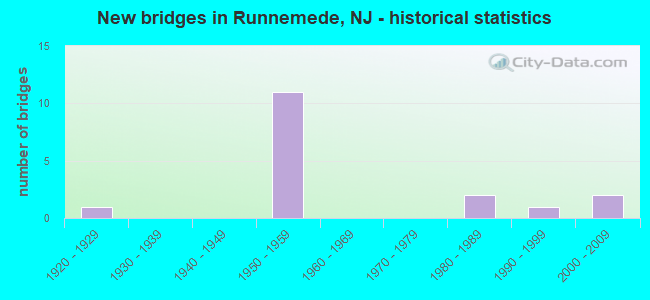
- New bridges - historical statistics
- 11920-1929
- 111950-1959
- 21980-1989
- 11990-1999
- 22000-2009

- Reconstructed bridges - Historical Statistics
- 11980-1989
- 21990-1999


- Bridge Condition - Deck
- 60.0%Good
- 20.0%Satisfactory
- 20.0%Fair

- Bridge Condition - Superstructure
- 10.0%Very good
- 40.0%Good
- 40.0%Satisfactory
- 10.0%Fair

- Bridge Condition - Substructure
- 20.0%Good
- 70.0%Satisfactory
- 10.0%Fair

- Bridge Condition - Channel
- 20.0%Good
- 80.0%Satisfactory
Find on map >> Show street view
Structure Number: 41215, Location: 0.85 MI S OF I-295 JCT (Lat: 39.854931, Lng: -75.098331), Route carried "on" structure: State highway 42, Year Built: 1956, Year Reconstructed: 1999, Status: Open, Structure Length: 5.30m (17.39ft), Average Daily Traffic: 59,016 (year 2021), Truck Traffic: 5%, Average Future Daily Traffic: 70,819 (year 2041), Design Load: HS 25 or greater, Features Intersected: NJ TURNPIKE
Minimum Vertical Clearance: 30+ m (98+ ft), Kilometerpoint: 21.324, Lanes on structure: 4, Lanes under structure: 4, Base Highway Network: Yes, Owner: State Highway Agency, Approaching Roadway Width: 24.4m (80.1ft), Material/Design: Steel, Design/Construction: Stringer/Multi-beam, Number Of Spans In Main Unit: 2, Length of Maximum Span: 25.6m (84.0ft), Curb-To-Curb Width: 23.5m (77.1ft), Out-to-Out Width: 24.4m (80.1ft)
Condition: Deck: Good, Superstructure: Good, Substructure: Satisfactory, Inventory Rating: 63.5 metric tons, Method Used To Determine Inventory Rating: Load Factor (LF), Structural Evaluation: Equal to present minimum criteria, Deck Geometry: Superior to present desirable criteria, Underclear: Meets minimum limits, Approach Roadway Alignment: Equal to present desirable criteria, Designated Inspection Frequency: Every 24 months, Inspection Date: June 2021, Deck Structure Type: Concrete Cast-file-Place, Wearing Surface/Protective System: Wearing Surface: Latex Concrete, Deck Protection: Epoxy Coated Reinforcing
Find on map >> Show street view
Structure Number: 412151, Location: 0.85 MI S OF I-295 JCT (Lat: 39.855000, Lng: -75.098331), Route carried "on" structure: State highway 42, Year Built: 1956, Year Reconstructed: 1999, Status: Open, Structure Length: 5.30m (17.39ft), Average Daily Traffic: 53,664 (year 2021), Truck Traffic: 5%, Average Future Daily Traffic: 64,397 (year 2041), Design Load: HS 25 or greater, Features Intersected: NJ TURNPIKE
Minimum Vertical Clearance: 30+ m (98+ ft), Kilometerpoint: 21.324, Lanes on structure: 5, Lanes under structure: 4, Base Highway Network: Yes, Owner: State Highway Agency, Approaching Roadway Width: 24.4m (80.1ft), Skew: 30 degrees, Material/Design: Steel, Design/Construction: Stringer/Multi-beam, Number Of Spans In Main Unit: 2, Length of Maximum Span: 25.6m (84.0ft), Curb-To-Curb Width: 23.5m (77.1ft), Out-to-Out Width: 24.4m (80.1ft)
Condition: Deck: Good, Superstructure: Good, Substructure: Satisfactory, Inventory Rating: 59.9 metric tons, Method Used To Determine Inventory Rating: Load Factor (LF), Structural Evaluation: Equal to present minimum criteria, Deck Geometry: Equal to present minimum criteria, Underclear: High priority of corrective action, Approach Roadway Alignment: Equal to present desirable criteria, Length Of Structure Improvement: 5.30m (17.39ft), Designated Inspection Frequency: Every 24 months, Inspection Date: June 2021, Bridge Improvement Cost: $1,530,000, Total Project Cost: $1,936,000 ( Estimate for 2021), Deck Structure Type: Concrete Cast-file-Place, Wearing Surface/Protective System: Wearing Surface: Bituminous, Membrane: Other, Deck Protection: Epoxy Coated Reinforcing
Find on map >> Show street view
Structure Number: 802151, Location: 0.75 MI N OF RT 42 JCT (Lat: 39.840311, Lng: -75.084139), Route carried "on" structure: State highway 41, Year Built: 1927, Status: Open, Structure Length: 4.21m (13.81ft), Average Daily Traffic: 28,916 (year 2021), Truck Traffic: 4%, Average Future Daily Traffic: 35,284 (year 2041), Features Intersected: SO. BR. BIG TIMBER CREEK
Minimum Vertical Clearance: 30+ m (98+ ft), Kilometerpoint: 6.647, Lanes on structure: 3, Base Highway Network: Yes, Owner: State Highway Agency, Approaching Roadway Width: 12.2m (40.0ft), Skew: 1 degrees, Material/Design: Steel, Design/Construction: Girder and Floorbeam System, Number Of Spans In Main Unit: 2, Length of Maximum Span: 20.1m (65.9ft), Curb or Sidewalk Widths: Left: 1.8m (5.9ft), Right: 1.8m (5.9ft), Curb-To-Curb Width: 12.2m (40.0ft), Out-to-Out Width: 12.6m (41.3ft)
Condition: Deck: Fair, Superstructure: Satisfactory, Substructure: Fair, Channel: Satisfactory, Operating Rating: 56.2 metric tons, Method Used To Determine Operating Rating: Load Factor (LF), Inventory Rating: 33.6 metric tons, Method Used To Determine Inventory Rating: Load Factor (LF), Structural Evaluation: Somewhat better than minimum adequacy, Deck Geometry: Meets minimum limits, Waterway Adequacy: Equal to present desirable criteria, Approach Roadway Alignment: Equal to present minimum criteria, Designated Inspection Frequency: Every 24 months, Critical Feature Inspection Frequency: Every 24 months, Underwater Inspection Frequency: Every 48 months, Inspection Date: May 2021, Critical Feature Inspection Date: May 2021, Underwater Inspection Date: September 2019, Deck Structure Type: Concrete Cast-file-Place, Wearing Surface/Protective System: Wearing Surface: Bituminous
Find on map >> Show street view
Structure Number: 804152, Location: 0.65 MI S OF 42-NJTPK JCT (Lat: 39.846669, Lng: -75.095000), Route carried "on" structure: State highway 42, Year Built: 1956, Status: Open, Structure Length: 0.67m (2.20ft), Average Daily Traffic: 152,368 (year 2021), Truck Traffic: 5%, Average Future Daily Traffic: 217,618 (year 2041), Design Load: H 20, Features Intersected: ALMONESSON CREEK
Minimum Vertical Clearance: 30+ m (98+ ft), Kilometerpoint: 20.229, Lanes on structure: 7, Base Highway Network: Yes, Owner: State Highway Agency, Approaching Roadway Width: 47.2m (154.9ft), Skew: 32 degrees, Material/Design: Concrete, Design/Construction: Culvert, Number Of Spans In Main Unit: 1, Length of Maximum Span: 6.7m (22.0ft)
Condition: Channel: Satisfactory, Culverts: Satisfactory, Operating Rating: 80.7 metric tons, Method Used To Determine Operating Rating: Load Factor (LF), Inventory Rating: 48.1 metric tons, Method Used To Determine Inventory Rating: Load Factor (LF), Structural Evaluation: Equal to present minimum criteria, Waterway Adequacy: Equal to present desirable criteria, Approach Roadway Alignment: Equal to present desirable criteria, Designated Inspection Frequency: Every 24 months, Underwater Inspection Frequency: Every 48 months, Inspection Date: September 2021, Underwater Inspection Date: June 2019
Find on map >> Show street view
Structure Number: 804153, Location: 0.1 MI S OF 42-NJTPK JCT (Lat: 39.852781, Lng: -75.096939), Route carried "on" structure: State highway 42, Year Built: 1999, Status: Open, Structure Length: 10.61m (34.81ft), Average Daily Traffic: 118,032 (year 2021), Truck Traffic: 5%, Average Future Daily Traffic: 141,638 (year 2041), Design Load: HS 20, Features Intersected: BIG TIMBER CREEK
Minimum Vertical Clearance: 30+ m (98+ ft), Kilometerpoint: 21.098, Lanes on structure: 9, Base Highway Network: Yes, Owner: State Highway Agency, Approaching Roadway Width: 45.4m (149.0ft), Skew: 34 degrees, Material/Design: Steel, Design/Construction: Stringer/Multi-beam, Number Of Spans In Main Unit: 5, Length of Maximum Span: 27.4m (89.9ft), Curb-To-Curb Width: 45.4m (149.0ft), Out-to-Out Width: 48.8m (160.1ft)
Condition: Deck: Good, Superstructure: Good, Substructure: Satisfactory, Channel: Good, Inventory Rating: 54.4 metric tons, Method Used To Determine Inventory Rating: Load Factor (LF), Structural Evaluation: Equal to present minimum criteria, Deck Geometry: Superior to present desirable criteria, Waterway Adequacy: Superior to present desirable criteria, Approach Roadway Alignment: Equal to present desirable criteria, Designated Inspection Frequency: Every 24 months, Underwater Inspection Frequency: Every 48 months, Inspection Date: June 2021, Underwater Inspection Date: June 2021, Deck Structure Type: Concrete Cast-file-Place, Wearing Surface/Protective System: Wearing Surface: Latex Concrete, Deck Protection: Epoxy Coated Reinforcing
Find on map >> Show street view
Structure Number: 832153, Location: 0.7 MI N.CO.RT621 & 55JCT (Lat: 39.842869, Lng: -75.095539), Route carried "on" structure: State highway 55, Year Built: 1985, Status: Open, Structure Length: 37.34m (122.51ft), Average Daily Traffic: 40,503 (year 2021), Truck Traffic: 5%, Average Future Daily Traffic: 48,604 (year 2041), Design Load: HS 20+Mod, Features Intersected: NJ 42 & ALMONESSON CK
Minimum Vertical Clearance: 30+ m (98+ ft), Kilometerpoint: 97.430, Lanes on structure: 1, Lanes under structure: 7, Base Highway Network: Yes, Owner: State Highway Agency, Approaching Roadway Width: 13.1m (43.0ft), Skew: 9 degrees, Material/Design: Steel continuous, Design/Construction: Stringer/Multi-beam, Number Of Spans In Main Unit: 5, Number Of Approach Spans: 3, Length of Maximum Span: 71.6m (234.9ft), Curb-To-Curb Width: 13.4m (44.0ft), Out-to-Out Width: 14.5m (47.6ft)
Condition: Deck: Good, Superstructure: Good, Substructure: Good, Channel: Satisfactory, Operating Rating: 65.3 metric tons, Method Used To Determine Operating Rating: Load Factor (LF), Inventory Rating: 38.1 metric tons, Method Used To Determine Inventory Rating: Load Factor (LF), Structural Evaluation: Better than present minimum criteria, Deck Geometry: Equal to present minimum criteria, Underclear: Equal to present minimum criteria, Waterway Adequacy: Superior to present desirable criteria, Approach Roadway Alignment: Better than present minimum criteria, Designated Inspection Frequency: Every 24 months, Inspection Date: August 2021, Deck Structure Type: Concrete Cast-file-Place, Wearing Surface/Protective System: Wearing Surface: Monolithic Concrete, Deck Protection: Epoxy Coated Reinforcing
Find on map >> Show street view
Structure Number: M02461, Location: 1.5 MI SOUTH OF EXIT 3 (Lat: 39.854264, Lng: -75.099889), Route carried "on" structure: Other road NJTPK, Year Built: 1950, Status: Open, Structure Length: 9.57m (31.40ft), Average Daily Traffic: 54,952 (year 2020), Truck Traffic: 5%, Average Future Daily Traffic: 67,052 (year 2040), Design Load: HS 20, Features Intersected: BIG TIMBER CREEK, Facility Carried by Structure: NJ TURNPIKE
Minimum Vertical Clearance: 30+ m (98+ ft), Kilometerpoint: 39.944, Lanes on structure: 4, Base Highway Network: Yes, Toll: On toll road, Owner: State Toll Authority, Approaching Roadway Width: 29.9m (98.1ft), Skew: 33 degrees, Navigation Control: Yes ( Vertical Clearance: 3.7m (12.1ft), Horizontal Clearance: 18.3m (60.0ft)), Material/Design: Steel continuous, Design/Construction: Stringer/Multi-beam, Number Of Spans In Main Unit: 5, Length of Maximum Span: 25.3m (83.0ft), Curb or Sidewalk Widths: Left: 0.6m (2.0ft), Right: 0.6m (2.0ft), Curb-To-Curb Width: 28.7m (94.2ft), Out-to-Out Width: 30.5m (100.1ft)
Condition: Deck: Fair, Superstructure: Satisfactory, Substructure: Satisfactory, Channel: Satisfactory, Operating Rating: 35.6 metric tons, Method Used To Determine Operating Rating: Load and Resistance Factor Rating (LRFR) rating reported by rating factor(RF) method using HL-93 loadings, Inventory Rating: 27.5 metric tons, Method Used To Determine Inventory Rating: Load and Resistance Factor Rating (LRFR) rating reported by rating factor(RF) method using HL-93 loadings, Structural Evaluation: Equal to present minimum criteria, Deck Geometry: Superior to present desirable criteria, Waterway Adequacy: Better than present minimum criteria, Approach Roadway Alignment: Equal to present desirable criteria, Designated Inspection Frequency: Every 24 months, Underwater Inspection Frequency: Every 48 months, Inspection Date: March 2020, Underwater Inspection Date: April 2018, Deck Structure Type: Concrete Cast-file-Place, Wearing Surface/Protective System: Wearing Surface: Bituminous, Membrane: Preformed Fabric
Find on map >> Show street view
Structure Number: M02572, Location: 0.4 MI SOUTH OF INT. 3 (Lat: 39.858850, Lng: -75.079439), Route carried "on" structure: Other road NJTPK, Year Built: 1950, Year Reconstructed: 1988, Status: Open, Structure Length: 2.59m (8.50ft), Average Daily Traffic: 54,952 (year 2020), Truck Traffic: 11%, Average Future Daily Traffic: 67,052 (year 2040), Design Load: H 20, Features Intersected: PRSL RR GRENLOCH BRANCH, Facility Carried by Structure: TURNPIKE MAINLINE
Minimum Vertical Clearance: 30+ m (98+ ft), Kilometerpoint: 41.714, Lanes on structure: 4, Base Highway Network: Yes, Toll: On toll road, Owner: State Toll Authority, Approaching Roadway Width: 29.6m (97.1ft), Skew: 30 degrees, Material/Design: Steel continuous, Design/Construction: Stringer/Multi-beam, Number Of Spans In Main Unit: 3, Length of Maximum Span: 8.5m (27.9ft), Curb or Sidewalk Widths: Left: 0.6m (2.0ft), Right: 0.6m (2.0ft), Curb-To-Curb Width: 28.3m (92.8ft), Out-to-Out Width: 30.5m (100.1ft)
Condition: Deck: Satisfactory, Superstructure: Satisfactory, Substructure: Satisfactory, Operating Rating: 42.1 metric tons, Method Used To Determine Operating Rating: Load and Resistance Factor Rating (LRFR) rating reported by rating factor(RF) method using HL-93 loadings, Inventory Rating: 32.4 metric tons, Method Used To Determine Inventory Rating: Load and Resistance Factor Rating (LRFR) rating reported by rating factor(RF) method using HL-93 loadings, Structural Evaluation: Equal to present minimum criteria, Deck Geometry: Superior to present desirable criteria, Approach Roadway Alignment: Equal to present desirable criteria, Designated Inspection Frequency: Every 24 months, Inspection Date: March 2020, Deck Structure Type: Concrete Cast-file-Place, Wearing Surface/Protective System: Wearing Surface: Bituminous, Membrane: Preformed Fabric
Find on map >> Show street view
Structure Number: M02588, Location: 0.2 MI SOUTH OF EXIT 3 (Lat: 39.859217, Lng: -75.076794), Route carried "on" structure: Other road NJTPK, Year Built: 1950, Status: Open, Structure Length: 5.43m (17.81ft), Average Daily Traffic: 54,952 (year 2020), Truck Traffic: 5%, Average Future Daily Traffic: 65,939 (year 2040), Design Load: H 20, Features Intersected: NJ 168(BLACK HORSE PIKE), Facility Carried by Structure: NJ TURNPIKE
Minimum Vertical Clearance: 30+ m (98+ ft), Kilometerpoint: 41.972, Lanes on structure: 5, Lanes under structure: 3, Base Highway Network: Yes, Toll: On toll road, Owner: State Toll Authority, Approaching Roadway Width: 36.0m (118.1ft), Skew: 31 degrees, Material/Design: Steel continuous, Design/Construction: Stringer/Multi-beam, Number Of Spans In Main Unit: 3, Length of Maximum Span: 22.9m (75.1ft), Curb or Sidewalk Widths: Left: 0.6m (2.0ft), Right: 0.6m (2.0ft), Curb-To-Curb Width: 37.1m (121.7ft), Out-to-Out Width: 39.8m (130.6ft)
Condition: Deck: Satisfactory, Superstructure: Fair, Substructure: Satisfactory, Operating Rating: 25.6 metric tons, Method Used To Determine Operating Rating: Load and Resistance Factor Rating (LRFR) rating reported by rating factor(RF) method using HL-93 loadings, Inventory Rating: 19.8 metric tons, Method Used To Determine Inventory Rating: Load and Resistance Factor Rating (LRFR) rating reported by rating factor(RF) method using HL-93 loadings, Structural Evaluation: Somewhat better than minimum adequacy, Deck Geometry: Superior to present desirable criteria, Underclear: Equal to present minimum criteria, Approach Roadway Alignment: Equal to present desirable criteria, Designated Inspection Frequency: Every 24 months, Inspection Date: March 2020, Deck Structure Type: Concrete Cast-file-Place, Wearing Surface/Protective System: Wearing Surface: Bituminous, Membrane: Preformed Fabric
Find on map >> Show street view
Structure Number: M02613B, Location: INTERCHANGE 3 (Lat: 39.861094, Lng: -75.077425), Route carried "on" structure: Ramp Other road NJTPK, Year Built: 1950, Status: Open, Structure Length: 4.11m (13.48ft), Average Daily Traffic: 5,714 (year 2020), Truck Traffic: 12%, Average Future Daily Traffic: 6,972 (year 2040), Design Load: HS 20, Features Intersected: NJ ROUTE 168, Facility Carried by Structure: TPK INT 3 WT & TE
Minimum Vertical Clearance: 30+ m (98+ ft), Kilometerpoint: 41.972, Lanes on structure: 2, Lanes under structure: 3, Toll: On toll road, Owner: State Toll Authority, Approaching Roadway Width: 14.0m (45.9ft), Skew: 20 degrees, Material/Design: Steel, Design/Construction: Stringer/Multi-beam, Number Of Spans In Main Unit: 3, Length of Maximum Span: 22.6m (74.1ft), Curb-To-Curb Width: 13.4m (44.0ft), Out-to-Out Width: 15.8m (51.8ft)
Condition: Deck: Good, Superstructure: Satisfactory, Substructure: Satisfactory, Operating Rating: 44.7 metric tons, Method Used To Determine Operating Rating: Load and Resistance Factor Rating (LRFR) rating reported by rating factor(RF) method using HL-93 loadings, Inventory Rating: 34.3 metric tons, Method Used To Determine Inventory Rating: Load and Resistance Factor Rating (LRFR) rating reported by rating factor(RF) method using HL-93 loadings, Structural Evaluation: Equal to present minimum criteria, Deck Geometry: Superior to present desirable criteria, Underclear: Meets minimum limits, Approach Roadway Alignment: Equal to present desirable criteria, Designated Inspection Frequency: Every 24 months, Inspection Date: April 2020, Deck Structure Type: Concrete Cast-file-Place, Wearing Surface/Protective System: Wearing Surface: Latex Concrete, Membrane: Other
Find on map >> Show street view
Structure Number: M2613AR, Location: AT INTERCHANGE 3 (Lat: 39.860200, Lng: -75.071744), Route carried "on" structure: Ramp Other road NJTPK, Year Built: 2005, Status: Open, Structure Length: 6.28m (20.60ft), Average Daily Traffic: 9,356 (year 2020), Truck Traffic: 12%, Average Future Daily Traffic: 11,415 (year 2040), Design Load: HS 25 or greater, Features Intersected: NJ TURNPIKE, Facility Carried by Structure: NJ TPK RAMPS C&E
Minimum Vertical Clearance: 30+ m (98+ ft), Kilometerpoint: 42.358, Lanes on structure: 2, Lanes under structure: 5, Toll: On toll road, Owner: State Toll Authority, Approaching Roadway Width: 15.2m (49.9ft), Skew: 20 degrees, Material/Design: Steel continuous, Design/Construction: Stringer/Multi-beam, Number Of Spans In Main Unit: 2, Length of Maximum Span: 34.7m (113.8ft), Curb-To-Curb Width: 15.2m (49.9ft), Out-to-Out Width: 17.7m (58.1ft)
Condition: Deck: Good, Superstructure: Very good, Substructure: Good, Operating Rating: 79.4 metric tons, Method Used To Determine Operating Rating: Load and Resistance Factor Rating (LRFR) rating reported by rating factor(RF) method using HL-93 loadings, Inventory Rating: 61.2 metric tons, Method Used To Determine Inventory Rating: Load and Resistance Factor Rating (LRFR) rating reported by rating factor(RF) method using HL-93 loadings, Structural Evaluation: Better than present minimum criteria, Deck Geometry: Superior to present desirable criteria, Underclear: Meets minimum limits, Approach Roadway Alignment: Equal to present desirable criteria, Designated Inspection Frequency: Every 24 months, Inspection Date: April 2020, Deck Structure Type: Concrete Cast-file-Place, Wearing Surface/Protective System: Deck Protection: Epoxy Coated Reinforcing
Find on map >> Show street view
Structure Number: 41215, Location: 0.85 MI S OF I-295 JCT (Lat: 39.854931, Lng: -75.098331), Route carried "under" structure: Other road NJTPK, Year Built: 1956, Structure Length: 0. m, Average Daily Traffic: 69,401 (year 2021), Truck Traffic: 5%, Features Intersected: NJ TURNPIKE, Facility Carried by Structure: NJ 42 NB
Minimum Vertical Clearance: 4.78m (15.68ft), Kilometerpoint: 40.073, Lanes on structure: 4, Lanes under structure: 4, Toll: On toll road, Material/Design: Steel, Design/Construction: Stringer/Multi-beam, Length of Maximum Span: 25.6m (84.0ft)
Find on map >> Show street view
Structure Number: 412151, Location: 0.85 MI S OF I-295 JCT (Lat: 39.855000, Lng: -75.098331), Route carried "under" structure: Other road NJTPK, Year Built: 1956, Structure Length: 0. m, Average Daily Traffic: 69,401 (year 2021), Truck Traffic: 5%, Features Intersected: NJ TURNPIKE, Facility Carried by Structure: NJ 42 SB
Minimum Vertical Clearance: 4.57m (14.99ft), Kilometerpoint: 40.073, Lanes on structure: 5, Lanes under structure: 4, Toll: On toll road, Material/Design: Steel, Design/Construction: Stringer/Multi-beam, Length of Maximum Span: 25.6m (84.0ft)
Find on map >> Show street view
Structure Number: 832153, Location: 0.7 MI N.CO.RT621 & 55JCT (Lat: 39.842869, Lng: -75.095539), Route carried "under" structure: State highway 42, Year Built: 1985, Structure Length: 0. m, Average Daily Traffic: 118,032 (year 2021), Truck Traffic: 5%, Features Intersected: NJ 42 & ALMONESSON CK, Facility Carried by Structure: NJ 55 NB
Minimum Vertical Clearance: 7.71m (25.30ft), Kilometerpoint: 20.181, Lanes on structure: 1, Lanes under structure: 7, Material/Design: Steel continuous, Design/Construction: Stringer/Multi-beam, Length of Maximum Span: 71.6m (234.9ft)
Find on map >> Show street view
Structure Number: M02588, Location: 0.2 MI SOUTH OF EXIT 3 (Lat: 39.859217, Lng: -75.076794), Route carried "under" structure: State highway 168, Year Built: 1950, Structure Length: 0. m, Average Daily Traffic: 20,680 (year 2020), Truck Traffic: 5%, Features Intersected: NJ 168(BLACK HORSE PIKE), Facility Carried by Structure: NJ TURNPIKE
Minimum Vertical Clearance: 5.77m (18.93ft), Kilometerpoint: 10.622, Lanes on structure: 5, Lanes under structure: 3, Toll: On toll road, Material/Design: Steel continuous, Design/Construction: Stringer/Multi-beam, Length of Maximum Span: 22.9m (75.1ft)
Find on map >> Show street view
Structure Number: M02613B, Location: INTERCHANGE 3 (Lat: 39.861094, Lng: -75.077425), Route carried "under" structure: State highway 168, Year Built: 1950, Structure Length: 0. m, Average Daily Traffic: 20,680 (year 2020), Truck Traffic: 4%, Features Intersected: NJ ROUTE 168, Facility Carried by Structure: TPK INT 3 WT & TE
Minimum Vertical Clearance: 4.55m (14.93ft), Kilometerpoint: 10.622, Lanes on structure: 2, Lanes under structure: 3, Material/Design: Steel, Design/Construction: Stringer/Multi-beam, Length of Maximum Span: 22.6m (74.1ft)
Find on map >> Show street view
Structure Number: M2613AR, Location: AT INTERCHANGE 3 (Lat: 39.860200, Lng: -75.071744), Route carried "under" structure: Other road NJTPK, Year Built: 2005, Structure Length: 0. m, Average Daily Traffic: 56,057 (year 2020), Truck Traffic: 12%, Features Intersected: NJ TURNPIKE, Facility Carried by Structure: NJ TPK RAMPS C&E
Minimum Vertical Clearance: 4.70m (15.42ft), Kilometerpoint: 42.358, Lanes on structure: 2, Lanes under structure: 5, Toll: On toll road, Material/Design: Steel continuous, Design/Construction: Stringer/Multi-beam, Length of Maximum Span: 34.7m (113.8ft)