Bridge Statistics for Rubidoux, California (CA)
Condition, Traffic, Stress, Structural Evaluation, Project Costs
- National Bridge Inventory (NBI) Statistics
- 13Number of bridges
- 102ft / 31.1mTotal length
- 744,724Total average daily traffic
- 87,108Total average daily truck traffic
- National Bridge Inventory (NBI) Registered Bridges for Rubidoux
- No street view available for this location
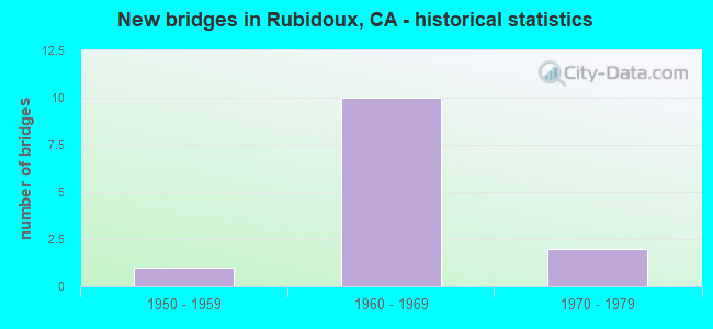
- New bridges - historical statistics
- 11950-1959
- 101960-1969
- 21970-1979

- Reconstructed bridges - Historical Statistics
- 11990-1999
- 12000-2009


- Bridge Condition - Deck
- 33.3%Good
- 66.7%Fair

- Bridge Condition - Superstructure
- 50.0%Good
- 50.0%Fair

- Bridge Condition - Substructure
- 83.3%Good
- 16.7%Fair

- Bridge Condition - Channel
- 80.0%Excellent
- 20.0%Very good
Find on map >> Show street view
Structure Number: 56 0414, Location: 08-RIV-060-9.54 (Lat: 34.004892, Lng: -117.400286), Route carried "on" structure: County highway R174, Year Built: 1962, Status: Open, Structure Length: 8.47m (27.79ft), Average Daily Traffic: 10,200 (year 2020), Truck Traffic: 3%, Average Future Daily Traffic: 12,911 (year 2042), Design Load: HS 20, Features Intersected: STATE ROUTE 60, Facility Carried by Structure: RUBIDOUX BLVD
Minimum Vertical Clearance: 30+ m (98+ ft), Kilometerpoint: 0.000, Lanes on structure: 5, Lanes under structure: 8, Owner: State Highway Agency, Approaching Roadway Width: 19.5m (64.0ft), Skew: 4 degrees, Material/Design: Concrete continuous, Design/Construction: Box Beam or Girders - Multiple, Number Of Spans In Main Unit: 4, Length of Maximum Span: 24.5m (80.4ft), Curb or Sidewalk Widths: Left: 2.1m (6.9ft), Right: 2.1m (6.9ft), Curb-To-Curb Width: 19.5m (64.0ft), Out-to-Out Width: 23.8m (78.1ft)
Condition: Deck: Fair, Superstructure: Fair, Substructure: Good, Operating Rating: 87.2 metric tons, Method Used To Determine Operating Rating: Load Factor (LF), Inventory Rating: 52.2 metric tons, Method Used To Determine Inventory Rating: Load Factor (LF), Structural Evaluation: Somewhat better than minimum adequacy, Deck Geometry: Meets minimum limits, Underclear: High priority of corrective action, Approach Roadway Alignment: Equal to present desirable criteria, Designated Inspection Frequency: Every 24 months, Inspection Date: December 2020, Deck Structure Type: Concrete Cast-file-Place
Find on map >> Show street view
Structure Number: 56 0415, Location: 08-RIV-060-9.96 (Lat: 34.005544, Lng: -117.393067), Route carried "on" structure: County highway R179, Year Built: 1962, Status: Open, Structure Length: 10.92m (35.83ft), Average Daily Traffic: 980 (year 2020), Truck Traffic: 2%, Average Future Daily Traffic: 1,095 (year 2042), Design Load: HS 20, Features Intersected: STATE ROUTE 60, Facility Carried by Structure: HALL AVENUE
Minimum Vertical Clearance: 30+ m (98+ ft), Kilometerpoint: 0.000, Lanes on structure: 2, Lanes under structure: 8, Owner: State Highway Agency, Approaching Roadway Width: 10.4m (34.1ft), Skew: 4 degrees, Material/Design: Prestressed concrete, Design/Construction: Stringer/Multi-beam, Number Of Spans In Main Unit: 4, Length of Maximum Span: 26.8m (87.9ft), Curb or Sidewalk Widths: Left: 2.1m (6.9ft), Right: 2.1m (6.9ft), Curb-To-Curb Width: 10.4m (34.1ft), Out-to-Out Width: 14.0m (45.9ft)
Condition: Deck: Fair, Superstructure: Good, Substructure: Good, Operating Rating: 41.1 metric tons, Method Used To Determine Operating Rating: Load and Resistance Factor Rating (LRFR) rating reported by rating factor(RF) method using HL-93 loadings, Inventory Rating: 23.3 metric tons, Method Used To Determine Inventory Rating: Load and Resistance Factor Rating (LRFR) rating reported by rating factor(RF) method using HL-93 loadings, Structural Evaluation: Equal to present minimum criteria, Deck Geometry: Equal to present minimum criteria, Underclear: Meets minimum limits, Approach Roadway Alignment: Equal to present desirable criteria, Designated Inspection Frequency: Every 24 months, Inspection Date: December 2020, Deck Structure Type: Concrete Cast-file-Place
Find on map >> Show street view
Structure Number: 56 0422, Location: 08-RIV-060-8.39 (Lat: 34.007350, Lng: -117.419983), Route carried "on" structure: State highway 60, Year Built: 1962, Year Reconstructed: 1999, Status: Open, Structure Length: 2.04m (6.69ft), Average Daily Traffic: 155,000 (year 2020), Truck Traffic: 12%, Average Future Daily Traffic: 205,000 (year 2040), Design Load: HS 20, Features Intersected: PACIFIC AVE
Minimum Vertical Clearance: 30+ m (98+ ft), Kilometerpoint: 8.390, Lanes on structure: 8, Lanes under structure: 2, Base Highway Network: Yes (, Subroute: 1), Owner: State Highway Agency, Approaching Roadway Width: 16.5m (54.1ft), Skew: 30 degrees, Material/Design: Concrete, Design/Construction: Stringer/Multi-beam, Number Of Spans In Main Unit: 1, Number Of Approach Spans: 6, Length of Maximum Span: 19.8m (65.0ft), Curb-To-Curb Width: 32.9m (107.9ft), Out-to-Out Width: 34.3m (112.5ft)
Condition: Deck: Good, Superstructure: Good, Substructure: Fair, Operating Rating: 72.3 metric tons, Method Used To Determine Operating Rating: Load Factor (LF), Inventory Rating: 32.4 metric tons, Method Used To Determine Inventory Rating: Load Factor (LF), Structural Evaluation: Somewhat better than minimum adequacy, Deck Geometry: Meets minimum limits, Underclear: Equal to present minimum criteria, Approach Roadway Alignment: Equal to present desirable criteria, Designated Inspection Frequency: Every 24 months, Inspection Date: December 2020, Deck Structure Type: Concrete Cast-file-Place
Find on map >> Show street view
Structure Number: 56 0479, Location: 08-RIV-060-8.81 (Lat: 34.005589, Lng: -117.413003), Route carried "on" structure: County highway , Year Built: 1962, Status: Open, Structure Length: 5.39m (17.68ft), Average Daily Traffic: 980 (year 2020), Truck Traffic: 2%, Average Future Daily Traffic: 1,203 (year 2042), Design Load: HS 20, Features Intersected: STATE ROUTE 60, Facility Carried by Structure: LA RUE ST
Minimum Vertical Clearance: 30+ m (98+ ft), Kilometerpoint: 0.000, Lanes on structure: 2, Lanes under structure: 8, Owner: State Highway Agency, Approaching Roadway Width: 9.8m (32.2ft), Skew: 1 degrees, Material/Design: Concrete continuous, Design/Construction: Box Beam or Girders - Multiple, Number Of Spans In Main Unit: 4, Length of Maximum Span: 18.3m (60.0ft), Curb or Sidewalk Widths: Left: 1.5m (4.9ft), Right: 1.5m (4.9ft), Curb-To-Curb Width: 9.8m (32.2ft), Out-to-Out Width: 14.0m (45.9ft)
Condition: Deck: Fair, Superstructure: Fair, Substructure: Good, Operating Rating: 35.6 metric tons, Method Used To Determine Operating Rating: Load and Resistance Factor Rating (LRFR) rating reported by rating factor(RF) method using HL-93 loadings, Inventory Rating: 27.5 metric tons, Method Used To Determine Inventory Rating: Load and Resistance Factor Rating (LRFR) rating reported by rating factor(RF) method using HL-93 loadings, Structural Evaluation: Somewhat better than minimum adequacy, Deck Geometry: Equal to present minimum criteria, Underclear: High priority of corrective action, Approach Roadway Alignment: Equal to present desirable criteria, Designated Inspection Frequency: Every 24 months, Inspection Date: December 2020, Deck Structure Type: Concrete Cast-file-Place
Find on map >> Show street view
Structure Number: 56 0524, Location: 08-RIV-060-10.30 (Lat: 34.004786, Lng: -117.387308), Route carried "on" structure: State highway 60, Year Built: 1962, Status: Open, Structure Length: 0.76m (2.49ft), Average Daily Traffic: 189,000 (year 2019), Truck Traffic: 12%, Average Future Daily Traffic: 223,000 (year 2040), Features Intersected: WATER STREET DRAIN
Minimum Vertical Clearance: 30+ m (98+ ft), Kilometerpoint: 10.300, Lanes on structure: 8, Base Highway Network: Yes (, Subroute: 1), Owner: State Highway Agency, Approaching Roadway Width: 16.5m (54.1ft), Skew: 30 degrees, Material/Design: Concrete continuous, Design/Construction: Culvert, Number Of Spans In Main Unit: 2, Length of Maximum Span: 3.7m (12.1ft), Curb-To-Curb Width: 34.3m (112.5ft), Out-to-Out Width: 34.7m (113.8ft)
Condition: Channel: Very good, Culverts: Satisfactory, Operating Rating: 54.1 metric tons, Method Used To Determine Operating Rating: Field evaluation and documented engineering judgment, Inventory Rating: 32.4 metric tons, Method Used To Determine Inventory Rating: Field evaluation and documented engineering judgment, Structural Evaluation: Equal to present minimum criteria, Deck Geometry: Somewhat better than minimum adequacy, Waterway Adequacy: Equal to present desirable criteria, Approach Roadway Alignment: Equal to present desirable criteria, Designated Inspection Frequency: Every 24 months, Inspection Date: June 2021
Find on map >> Show street view
Structure Number: 56C0178, Location: 0.2 MI. W/O PACIFIC AVE. (Lat: 34.002614, Lng: -117.423836), Route carried "on" structure: County highway , Year Built: 1958, Status: Open, Structure Length: 0.79m (2.59ft), Average Daily Traffic: 2,702 (year 2012), Truck Traffic: 1%, Average Future Daily Traffic: 2,088 (year 2040), Features Intersected: SUNNYSLOPE STORM CHANNEL, Facility Carried by Structure: RUSTIC LANE
Minimum Vertical Clearance: 30+ m (98+ ft), Kilometerpoint: 0.000, Lanes on structure: 2, Owner: County Highway Agency, Approaching Roadway Width: 11.0m (36.1ft), Material/Design: Prestressed concrete, Design/Construction: Slab, Number Of Spans In Main Unit: 1, Length of Maximum Span: 7.3m (24.0ft), Curb or Sidewalk Widths: Left: 1.2m (3.9ft), Right: 1.2m (3.9ft), Curb-To-Curb Width: 11.0m (36.1ft), Out-to-Out Width: 14.1m (46.3ft)
Condition: Deck: Good, Superstructure: Good, Substructure: Good, Channel: Excellent, Operating Rating: 40.5 metric tons, Method Used To Determine Operating Rating: Field evaluation and documented engineering judgment, Inventory Rating: 24.3 metric tons, Method Used To Determine Inventory Rating: Field evaluation and documented engineering judgment, Structural Evaluation: Equal to present minimum criteria, Deck Geometry: Somewhat better than minimum adequacy, Waterway Adequacy: Superior to present desirable criteria, Approach Roadway Alignment: Equal to present minimum criteria, Designated Inspection Frequency: Every 24 months, Inspection Date: April 2020, Deck Structure Type: Concrete Precast Panels, Wearing Surface/Protective System: Wearing Surface: Bituminous
Find on map >> Show street view
Structure Number: 56C0209, Location: 0.3 MI. S/O LIMONITE AVE. (Lat: 33.988603, Lng: -117.423019), Route carried "on" structure: County highway , Year Built: 1965, Status: Open, Structure Length: 1.22m (4.00ft), Average Daily Traffic: 2,000 (year 2012), Truck Traffic: 1%, Average Future Daily Traffic: 4,094 (year 2040), Features Intersected: SUNNYSLOPE STORM CHAN, Facility Carried by Structure: RIVERVIEW DRIVE
Minimum Vertical Clearance: 30+ m (98+ ft), Kilometerpoint: 0.000, Lanes on structure: 2, Owner: County Highway Agency, Approaching Roadway Width: 6.7m (22.0ft), Skew: 5 degrees, Material/Design: Concrete, Design/Construction: Culvert, Number Of Spans In Main Unit: 2, Length of Maximum Span: 4.7m (15.4ft), Curb-To-Curb Width: 13.1m (43.0ft), Out-to-Out Width: 24.1m (79.1ft)
Condition: Channel: Excellent, Culverts: Satisfactory, Operating Rating: 40.5 metric tons, Method Used To Determine Operating Rating: Field evaluation and documented engineering judgment, Inventory Rating: 24.3 metric tons, Method Used To Determine Inventory Rating: Field evaluation and documented engineering judgment, Structural Evaluation: Equal to present minimum criteria, Deck Geometry: Better than present minimum criteria, Waterway Adequacy: Superior to present desirable criteria, Approach Roadway Alignment: Equal to present minimum criteria, Designated Inspection Frequency: Every 24 months, Inspection Date: April 2020, Deck Structure Type: Concrete Cast-file-Place
Find on map >> Show street view
Structure Number: 56C0366, Location: 0.2 MI. SE/O RIVERVIEW DR (Lat: 33.981069, Lng: -117.423375), Route carried "on" structure: County highway , Year Built: 1970, Status: Open, Structure Length: 0.79m (2.59ft), Average Daily Traffic: 88 (year 2012), Average Future Daily Traffic: 105 (year 2040), Features Intersected: SUNNYSLOPE STORM CHANNEL, Facility Carried by Structure: RIO ROAD
Minimum Vertical Clearance: 30+ m (98+ ft), Kilometerpoint: 0.000, Lanes on structure: 2, Owner: County Highway Agency, Approaching Roadway Width: 7.4m (24.3ft), Material/Design: Concrete, Design/Construction: Culvert, Number Of Spans In Main Unit: 2, Length of Maximum Span: 3.7m (12.1ft), Curb-To-Curb Width: 7.4m (24.3ft), Out-to-Out Width: 12.2m (40.0ft)
Condition: Channel: Excellent, Culverts: Satisfactory, Operating Rating: 40.5 metric tons, Method Used To Determine Operating Rating: Field evaluation and documented engineering judgment, Inventory Rating: 24.3 metric tons, Method Used To Determine Inventory Rating: Field evaluation and documented engineering judgment, Structural Evaluation: Equal to present minimum criteria, Deck Geometry: Equal to present minimum criteria, Waterway Adequacy: Superior to present desirable criteria, Approach Roadway Alignment: Equal to present desirable criteria, Designated Inspection Frequency: Every 24 months, Inspection Date: April 2020, Deck Structure Type: Concrete Cast-file-Place
Find on map >> Show street view
Structure Number: 56C0367, Location: 0.3 MI. SE/O RIVERVIEW DR (Lat: 33.987236, Lng: -117.418294), Route carried "on" structure: County highway , Year Built: 1972, Year Reconstructed: 2000, Status: Open, Structure Length: 0.76m (2.49ft), Average Daily Traffic: 3,774 (year 2012), Truck Traffic: 1%, Average Future Daily Traffic: 2,081 (year 2040), Features Intersected: RUBIDOUX CHANNEL, Facility Carried by Structure: 46TH STREET
Minimum Vertical Clearance: 30+ m (98+ ft), Kilometerpoint: 0.000, Lanes on structure: 2, Owner: County Highway Agency, Approaching Roadway Width: 7.0m (23.0ft), Skew: 1 degrees, Material/Design: Concrete, Design/Construction: Slab, Number Of Spans In Main Unit: 1, Length of Maximum Span: 7.1m (23.3ft), Curb-To-Curb Width: 10.0m (32.8ft), Out-to-Out Width: 10.3m (33.8ft)
Condition: Deck: Fair, Superstructure: Fair, Substructure: Good, Channel: Excellent, Operating Rating: 58.6 metric tons, Method Used To Determine Operating Rating: Load Factor (LF), Inventory Rating: 35.3 metric tons, Method Used To Determine Inventory Rating: Load Factor (LF), Structural Evaluation: Somewhat better than minimum adequacy, Deck Geometry: Meets minimum limits, Waterway Adequacy: Superior to present desirable criteria, Approach Roadway Alignment: Equal to present desirable criteria, Designated Inspection Frequency: Every 24 months, Inspection Date: April 2020, Deck Structure Type: Concrete Cast-file-Place
Find on map >> Show street view
Structure Number: 56 0414, Location: 08-RIV-060-9.54 (Lat: 34.004892, Lng: -117.400286), Route carried "under" structure: State highway 60, Year Built: 1962, Structure Length: 0. m, Average Daily Traffic: 126,000 (year 2020), Truck Traffic: 12%, Features Intersected: STATE ROUTE 60, Facility Carried by Structure: RUBIDOUX BLVD
Minimum Vertical Clearance: 4.62m (15.16ft), Kilometerpoint: 9.540, Lanes on structure: 5, Lanes under structure: 8, Material/Design: Concrete continuous, Design/Construction: Box Beam or Girders - Multiple, Length of Maximum Span: 24.5m (80.4ft)
Find on map >> Show street view
Structure Number: 56 0415, Location: 08-RIV-060-9.96 (Lat: 34.005544, Lng: -117.393067), Route carried "under" structure: State highway 60, Year Built: 1962, Structure Length: 0. m, Average Daily Traffic: 126,000 (year 2020), Truck Traffic: 12%, Features Intersected: STATE ROUTE 60, Facility Carried by Structure: HALL AVENUE
Minimum Vertical Clearance: 11.25m (36.91ft), Kilometerpoint: 9.960, Lanes on structure: 2, Lanes under structure: 8, Material/Design: Prestressed concrete, Design/Construction: Stringer/Multi-beam, Length of Maximum Span: 26.8m (87.9ft)
Find on map >> Show street view
Structure Number: 56 0422, Location: 08-RIV-060-8.39 (Lat: 34.007350, Lng: -117.419983), Route carried "under" structure: County highway R173, Year Built: 1962, Structure Length: 0. m, Average Daily Traffic: 2,000 (year 2020), Truck Traffic: 2%, Features Intersected: PACIFIC AVE, Facility Carried by Structure: STATE ROUTE 60
Minimum Vertical Clearance: 4.72m (15.49ft), Kilometerpoint: 0.000, Lanes on structure: 8, Lanes under structure: 2, Material/Design: Concrete, Design/Construction: Stringer/Multi-beam, Length of Maximum Span: 19.8m (65.0ft)
Find on map >> Show street view
Structure Number: 56 0479, Location: 08-RIV-060-8.81 (Lat: 34.005589, Lng: -117.413003), Route carried "under" structure: State highway 60, Year Built: 1962, Structure Length: 0. m, Average Daily Traffic: 126,000 (year 2020), Truck Traffic: 12%, Features Intersected: STATE ROUTE 60, Facility Carried by Structure: LA RUE ST
Minimum Vertical Clearance: 4.67m (15.32ft), Kilometerpoint: 8.810, Lanes on structure: 2, Lanes under structure: 8, Material/Design: Concrete continuous, Design/Construction: Box Beam or Girders - Multiple, Length of Maximum Span: 18.3m (60.0ft)