Bridge Statistics for Rossville, Maryland (MD)
Condition, Traffic, Stress, Structural Evaluation, Project Costs
- National Bridge Inventory (NBI) Statistics
- 15Number of bridges
- 203ft / 62.4mTotal length
- $5,120,000Total costs
- 674,681Total average daily traffic
- 47,956Total average daily truck traffic
- National Bridge Inventory (NBI) Registered Bridges for Rossville
- No street view available for this location
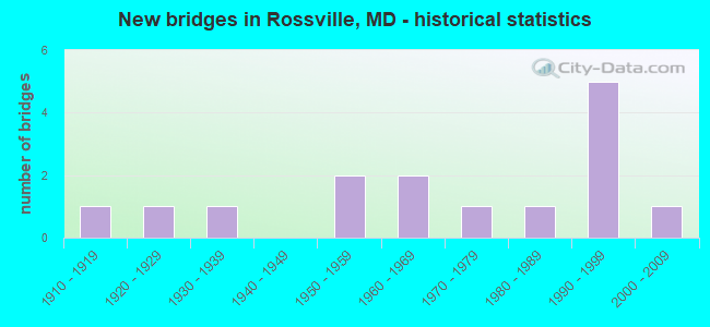
- New bridges - historical statistics
- 11910-1919
- 11920-1929
- 11930-1939
- 21950-1959
- 21960-1969
- 11970-1979
- 11980-1989
- 51990-1999
- 12000-2009


- Bridge Condition - Deck
- 66.7%Good
- 22.2%Satisfactory
- 11.1%Serious

- Bridge Condition - Superstructure
- 18.2%Very good
- 36.4%Good
- 27.3%Satisfactory
- 9.1%Poor
- 9.1%Critical

- Bridge Condition - Substructure
- 9.1%Very good
- 54.5%Good
- 27.3%Satisfactory
- 9.1%Critical

- Bridge Condition - Channel
- 20.0%Satisfactory
- 60.0%Fair
- 20.0%Poor

- Bridge Condition - Culverts
- 50.0%Good
- 50.0%Satisfactory
Find on map >> Show street view
Structure Number: 10000003001602, Location: 0.38 MI E OF MD 695 (Lat: 39.339575, Lng: -76.486317), Route carried "on" structure: State highway 7, Year Built: 1973, Status: Open, Structure Length: 1.34m (4.40ft), Average Daily Traffic: 39,620 (year 2012), Truck Traffic: 8%, Average Future Daily Traffic: 46,304 (year 2026), Design Load: HS 20, Features Intersected: STEMMERS RUN
Minimum Vertical Clearance: 30+ m (98+ ft), Kilometerpoint: 4.666, Lanes on structure: 8, Owner: State Highway Agency, Approaching Roadway Width: 28.7m (94.2ft), Material/Design: Concrete, Design/Construction: Culvert, Length of Maximum Span: 4.3m (14.1ft)
Condition: Channel: Fair, Culverts: Satisfactory, Operating Rating: 32.7 metric tons, Method Used To Determine Operating Rating: Field evaluation and documented engineering judgment, Inventory Rating: 32.7 metric tons, Method Used To Determine Inventory Rating: Field evaluation and documented engineering judgment, Structural Evaluation: Equal to present minimum criteria, Waterway Adequacy: Meets minimum limits, Approach Roadway Alignment: Equal to present desirable criteria, Designated Inspection Frequency: Every 24 months, Inspection Date: June 2020
Find on map >> Show street view
Structure Number: 10000003019001, Location: 0.27 MILE NORTH OF MD 588 (Lat: 39.335881, Lng: -76.492061), Route carried "on" structure: State highway 7, Year Built: 1958, Year Reconstructed: 1986, Status: Open, Structure Length: 6.92m (22.70ft), Average Daily Traffic: 35,080 (year 2009), Truck Traffic: 8%, Average Future Daily Traffic: 33,470 (year 2029), Design Load: HS 20, Features Intersected: MD 695
Minimum Vertical Clearance: 30+ m (98+ ft), Kilometerpoint: 4.055, Lanes on structure: 5, Lanes under structure: 8, Owner: State Highway Agency, Approaching Roadway Width: 17.4m (57.1ft), Material/Design: Steel, Design/Construction: Stringer/Multi-beam, Number Of Spans In Main Unit: 4, Length of Maximum Span: 21.3m (69.9ft), Curb or Sidewalk Widths: Left: 0.0m, Right: 1.3m (4.3ft), Curb-To-Curb Width: 17.4m (57.1ft), Out-to-Out Width: 19.4m (63.6ft)
Condition: Deck: Good, Superstructure: Satisfactory, Substructure: Satisfactory, Operating Rating: 77.1 metric tons, Method Used To Determine Operating Rating: Load Factor (LF), Inventory Rating: 46.3 metric tons, Method Used To Determine Inventory Rating: Load Factor (LF), Structural Evaluation: Equal to present minimum criteria, Deck Geometry: High priority of replacement, Underclear: Meets minimum limits, Approach Roadway Alignment: Equal to present desirable criteria, Length Of Structure Improvement: 6.92m (22.70ft), Designated Inspection Frequency: Every 24 months, Inspection Date: July 2021, Bridge Improvement Cost: $868,000, Roadway Improvement Cost: $87,000, Total Project Cost: $955,000, Deck Structure Type: Concrete Cast-file-Place, Wearing Surface/Protective System: Wearing Surface: Bituminous
Find on map >> Show street view
Structure Number: 10000003019101, Location: 0.25 MILE EAST OF MD 7 (Lat: 39.332436, Lng: -76.488217), Route carried "on" structure: Interstate 695, Year Built: 1996, Status: Open, Structure Length: 5.70m (18.70ft), Average Daily Traffic: 96,082 (year 2009), Truck Traffic: 10%, Average Future Daily Traffic: 114,461 (year 2026), Design Load: HS 25 or greater, Features Intersected: US 40(PULASKI HWY)
Minimum Vertical Clearance: 30+ m (98+ ft), Kilometerpoint: 1.657, Lanes on structure: 8, Lanes under structure: 6, Base Highway Network: Yes, Owner: State Highway Agency, Approaching Roadway Width: 53.3m (174.9ft), Skew: 30 degrees, Material/Design: Steel continuous, Design/Construction: Stringer/Multi-beam, Number Of Spans In Main Unit: 2, Length of Maximum Span: 29.6m (97.1ft), Curb-To-Curb Width: 48.5m (159.1ft), Out-to-Out Width: 50.6m (166.0ft)
Condition: Deck: Good, Superstructure: Good, Substructure: Good, Inventory Rating: 55.3 metric tons, Method Used To Determine Inventory Rating: Load Factor (LF), Structural Evaluation: Better than present minimum criteria, Deck Geometry: Superior to present desirable criteria, Underclear: Equal to present minimum criteria, Approach Roadway Alignment: Equal to present desirable criteria, Designated Inspection Frequency: Every 24 months, Inspection Date: Febuary 2021, Deck Structure Type: Concrete Cast-file-Place, Wearing Surface/Protective System: Wearing Surface: Monolithic Concrete, Deck Protection: Epoxy Coated Reinforcing
Find on map >> Show street view
Structure Number: 10000003025001, Location: 0.05 MI E OF US 40 (Lat: 39.331306, Lng: -76.487025), Route carried "on" structure: Interstate 695, Year Built: 1995, Status: Open, Structure Length: 5.18m (16.99ft), Average Daily Traffic: 96,082 (year 2009), Truck Traffic: 10%, Average Future Daily Traffic: 114,461 (year 2026), Design Load: HS 25 or greater, Features Intersected: CSX RAILROAD
Minimum Vertical Clearance: 30+ m (98+ ft), Kilometerpoint: 1.834, Lanes on structure: 6, Base Highway Network: Yes, Owner: State Highway Agency, Approaching Roadway Width: 46.3m (151.9ft), Skew: 30 degrees, Material/Design: Steel continuous, Design/Construction: Stringer/Multi-beam, Number Of Spans In Main Unit: 3, Length of Maximum Span: 21.0m (68.9ft), Curb-To-Curb Width: 45.4m (149.0ft), Out-to-Out Width: 47.5m (155.8ft)
Condition: Deck: Good, Superstructure: Good, Substructure: Good, Operating Rating: 87.1 metric tons, Method Used To Determine Operating Rating: Load Factor (LF), Inventory Rating: 52.2 metric tons, Method Used To Determine Inventory Rating: Load Factor (LF), Structural Evaluation: Better than present minimum criteria, Deck Geometry: Superior to present desirable criteria, Underclear: Equal to present desirable criteria, Approach Roadway Alignment: Equal to present desirable criteria, Designated Inspection Frequency: Every 24 months, Inspection Date: September 2021, Deck Structure Type: Concrete Cast-file-Place, Wearing Surface/Protective System: Wearing Surface: Monolithic Concrete, Deck Protection: Epoxy Coated Reinforcing
Find on map >> Show street view
Structure Number: 200000B-005801, Location: 0.14 MI S OF ROSSVIL BLVD (Lat: 39.331086, Lng: -76.476442), Route carried "on" structure: County highway 4547, Year Built: 1929, Status: Posted for load, Structure Length: 1.43m (4.69ft), Average Daily Traffic: 1,700 (year 2021), Truck Traffic: 5%, Average Future Daily Traffic: 3,300 (year 2041), Features Intersected: STEMMERS RUN, Facility Carried by Structure: RACE ROAD
Minimum Vertical Clearance: 30+ m (98+ ft), Kilometerpoint: 0.225, Lanes on structure: 2, Owner: County Highway Agency, Approaching Roadway Width: 6.1m (20.0ft), Material/Design: Concrete, Design/Construction: Arch - Deck, Number Of Spans In Main Unit: 1, Length of Maximum Span: 13.7m (44.9ft), Curb or Sidewalk Widths: Left: 0.2m (0.7ft), Right: 0.2m (0.7ft), Curb-To-Curb Width: 6.1m (20.0ft), Out-to-Out Width: 7.0m (23.0ft)
Condition: Superstructure: Satisfactory, Substructure: Satisfactory, Channel: Fair, Operating Rating: 28.6 metric tons, Method Used To Determine Operating Rating: Load Factor (LF), Inventory Rating: 16.8 metric tons, Method Used To Determine Inventory Rating: Load Factor (LF), Structural Evaluation: Meets minimum limits, Deck Geometry: High priority of replacement, Waterway Adequacy: Better than present minimum criteria, Approach Roadway Alignment: Equal to present desirable criteria, Bridge Posting: Required (Relationship of Operating Rating to Maximum Legal Load: > 39.9% below), Designated Inspection Frequency: Every 24 months, Underwater Inspection Frequency: Every 48 months, Other Special Inspection Frequency: Every 12 months, Inspection Date: November 2021, Underwater Inspection Date: November 2019, Other Special Inspection Date: November 2021
Find on map >> Show street view
Structure Number: 200000B-011001, Location: 0.05 MI N OF OREMS RD (Lat: 39.329433, Lng: -76.473944), Route carried "on" structure: County highway 4548, Year Built: 1933, Status: Closed, Structure Length: 1.43m (4.69ft), Average Daily Traffic: 3,841 (year 2021), Truck Traffic: 5%, Average Future Daily Traffic: 4,886 (year 2041), Features Intersected: STEMMERS RUN, Facility Carried by Structure: GOLDEN RING ROAD
Minimum Vertical Clearance: 30+ m (98+ ft), Kilometerpoint: 0.467, Lanes on structure: 2, Owner: County Highway Agency, Approaching Roadway Width: 6.1m (20.0ft), Material/Design: Concrete, Design/Construction: Arch - Deck, Number Of Spans In Main Unit: 1, Length of Maximum Span: 13.7m (44.9ft), Curb-To-Curb Width: 6.1m (20.0ft), Out-to-Out Width: 7.0m (23.0ft)
Condition: Superstructure: Poor, Substructure: Satisfactory, Channel: Poor, Operating Rating: 45.8 metric tons, Method Used To Determine Operating Rating: Load Factor (LF), Inventory Rating: 27.2 metric tons, Method Used To Determine Inventory Rating: Load Factor (LF), Structural Evaluation: Meets minimum limits, Waterway Adequacy: Better than present minimum criteria, Approach Roadway Alignment: Somewhat better than minimum adequacy, Designated Inspection Frequency: Every 12 months, Inspection Date: October 2021, Wearing Surface/Protective System: Wearing Surface: Bituminous
Find on map >> Show street view
Structure Number: 200000B-014301, Location: 0.1 MI NW OF US RTE 40 (Lat: 39.361400, Lng: -76.447100), Route carried "on" structure: County highway 4183, Year Built: 1912, Year Reconstructed: 1989, Status: Closed, Structure Length: 4.42m (14.50ft), Average Daily Traffic: 1,600 (year 1996), Truck Traffic: 5%, Average Future Daily Traffic: 4,000 (year 2016), Features Intersected: CSX RAILROAD, Facility Carried by Structure: MOHRS LANE
Minimum Vertical Clearance: 30+ m (98+ ft), Kilometerpoint: 0.467, Lanes on structure: 1, Owner: County Highway Agency, Approaching Roadway Width: 4.0m (13.1ft), Skew: 1 degrees, Material/Design: Steel, Design/Construction: Girder and Floorbeam System, Number Of Spans In Main Unit: 1, Number Of Approach Spans: 3, Length of Maximum Span: 19.2m (63.0ft), Curb-To-Curb Width: 3.8m (12.5ft), Out-to-Out Width: 4.9m (16.1ft)
Condition: Deck: Serious, Superstructure: Critical, Substructure: Critical, Operating Rating: 12.7 metric tons, Method Used To Determine Operating Rating: No rating analysis performed, Inventory Rating: 9.1 metric tons, Method Used To Determine Inventory Rating: No rating analysis performed, Underclear: Somewhat better than minimum adequacy, Approach Roadway Alignment: High priority of corrective action, Bridge Posting: Required (Relationship of Operating Rating to Maximum Legal Load: > 39.9% below), Length Of Structure Improvement: 4.42m (14.50ft), Designated Inspection Frequency: Every 24 months, Critical Feature Inspection Frequency: Every 24 months, Inspection Date: May 2009, Critical Feature Inspection Date: May 2009, Bridge Improvement Cost: $4,160,000, Roadway Improvement Cost: $5,000, Total Project Cost: $4,165,000, Deck Structure Type: Wood or Timber, Wearing Surface/Protective System: Wearing Surface: Wood or Timber
Find on map >> Show street view
Structure Number: 200000B-040801, Location: 0.2 MI SW OF ROSSVILLE RD (Lat: 39.332742, Lng: -76.478353), Route carried "on" structure: County highway , Year Built: 1988, Status: Open, Structure Length: 7.74m (25.39ft), Average Daily Traffic: 5,707 (year 2021), Truck Traffic: 5%, Average Future Daily Traffic: 8,480 (year 2041), Design Load: HS 20, Features Intersected: STEMMERS RUN, Facility Carried by Structure: KELSO DRIVE
Minimum Vertical Clearance: 30+ m (98+ ft), Kilometerpoint: 0.000, Lanes on structure: 4, Owner: County Highway Agency, Approaching Roadway Width: 15.2m (49.9ft), Material/Design: Steel continuous, Design/Construction: Stringer/Multi-beam, Number Of Spans In Main Unit: 3, Length of Maximum Span: 30.5m (100.1ft), Curb or Sidewalk Widths: Left: 1.8m (5.9ft), Right: 1.8m (5.9ft), Curb-To-Curb Width: 15.2m (49.9ft), Out-to-Out Width: 19.5m (64.0ft)
Condition: Deck: Good, Superstructure: Satisfactory, Substructure: Good, Channel: Satisfactory, Inventory Rating: 55.8 metric tons, Method Used To Determine Inventory Rating: Load Factor (LF), Structural Evaluation: Equal to present minimum criteria, Deck Geometry: High priority of corrective action, Waterway Adequacy: Equal to present desirable criteria, Approach Roadway Alignment: Equal to present desirable criteria, Designated Inspection Frequency: Every 24 months, Inspection Date: April 2021, Deck Structure Type: Concrete Cast-file-Place, Wearing Surface/Protective System: Wearing Surface: Integral Concrete
Find on map >> Show street view
Structure Number: 200000B-053402, Location: 1.8 MI SW OF RT 7 (Lat: 39.360222, Lng: -8.054267), Route carried "on" structure: Other road 4461, Year Built: 1999, Status: Open, Structure Length: 0.77m (2.53ft), Average Daily Traffic: 15,245 (year 2020), Truck Traffic: 5%, Average Future Daily Traffic: 23,568 (year 2042), Features Intersected: SOUTH FORK OF WHITE MARS, Facility Carried by Structure: FRANKLIN SQUARE BO
Minimum Vertical Clearance: 30+ m (98+ ft), Kilometerpoint: 0.000, Lanes on structure: 4, Owner: County Highway Agency, Approaching Roadway Width: 15.5m (50.9ft), Material/Design: Concrete, Design/Construction: Culvert, Length of Maximum Span: 3.7m (12.1ft), Curb or Sidewalk Widths: Left: 0.0m, Right: 1.2m (3.9ft)
Condition: Channel: Fair, Culverts: Good, Structural Evaluation: Better than present minimum criteria, Waterway Adequacy: Somewhat better than minimum adequacy, Approach Roadway Alignment: Equal to present desirable criteria, Designated Inspection Frequency: Every 24 months, Inspection Date: January 2020
Find on map >> Show street view
Structure Number: 300000B-X64401, Location: 0.62 MI N OF IS 695 (Lat: 39.356672, Lng: -76.486997), Route carried "on" structure: County highway 4458, Year Built: 2005, Status: Open, Structure Length: 11.55m (37.89ft), Average Daily Traffic: 23,316 (year 2019), Truck Traffic: 3%, Average Future Daily Traffic: 28,396 (year 2041), Design Load: HS 25 or greater, Features Intersected: I-95, Facility Carried by Structure: ROSSVILLE BLVD
Minimum Vertical Clearance: 30+ m (98+ ft), Kilometerpoint: 103.652, Lanes on structure: 2, Lanes under structure: 8, Owner: State Toll Authority, Approaching Roadway Width: 21.3m (69.9ft), Material/Design: Steel continuous, Design/Construction: Stringer/Multi-beam, Number Of Spans In Main Unit: 2, Length of Maximum Span: 57.0m (187.0ft), Curb or Sidewalk Widths: Left: 1.6m (5.2ft), Right: 1.6m (5.2ft), Curb-To-Curb Width: 21.3m (69.9ft), Out-to-Out Width: 25.3m (83.0ft)
Condition: Deck: Satisfactory, Superstructure: Good, Substructure: Good, Operating Rating: 83.0 metric tons, Method Used To Determine Operating Rating: Load Factor (LF), Inventory Rating: 49.4 metric tons, Method Used To Determine Inventory Rating: Load Factor (LF), Structural Evaluation: Better than present minimum criteria, Deck Geometry: Superior to present desirable criteria, Underclear: Meets minimum limits, Approach Roadway Alignment: Better than present minimum criteria, Designated Inspection Frequency: Every 24 months, Inspection Date: December 2021, Deck Structure Type: Concrete Cast-file-Place, Wearing Surface/Protective System: Wearing Surface: Monolithic Concrete, Deck Protection: Epoxy Coated Reinforcing
Find on map >> Show street view
Structure Number: 300000B-X64901, Location: 0.45 MI N OF ROSSVILE BLD (Lat: 39.359917, Lng: -76.480225), Route carried "on" structure: County highway 4189, Year Built: 1997, Status: Open, Structure Length: 8.99m (29.49ft), Average Daily Traffic: 4,994 (year 2019), Truck Traffic: 5%, Average Future Daily Traffic: 6,082 (year 2041), Design Load: HS 25 or greater, Features Intersected: I-95, Facility Carried by Structure: KING AVENUE
Minimum Vertical Clearance: 30+ m (98+ ft), Kilometerpoint: 104.360, Lanes on structure: 2, Lanes under structure: 8, Owner: State Toll Authority, Approaching Roadway Width: 9.8m (32.2ft), Skew: 3 degrees, Material/Design: Steel continuous, Design/Construction: Stringer/Multi-beam, Number Of Spans In Main Unit: 2, Length of Maximum Span: 44.2m (145.0ft), Curb or Sidewalk Widths: Left: 0.0m, Right: 1.5m (4.9ft), Curb-To-Curb Width: 9.8m (32.2ft), Out-to-Out Width: 12.3m (40.4ft)
Condition: Deck: Satisfactory, Superstructure: Good, Substructure: Good, Operating Rating: 70.3 metric tons, Method Used To Determine Operating Rating: Load Factor (LF), Inventory Rating: 42.2 metric tons, Method Used To Determine Inventory Rating: Load Factor (LF), Structural Evaluation: Better than present minimum criteria, Deck Geometry: Meets minimum limits, Underclear: Meets minimum limits, Approach Roadway Alignment: Better than present minimum criteria, Designated Inspection Frequency: Every 24 months, Inspection Date: December 2021, Deck Structure Type: Concrete Cast-file-Place, Wearing Surface/Protective System: Wearing Surface: Monolithic Concrete, Deck Protection: Epoxy Coated Reinforcing
Find on map >> Show street view
Structure Number: 300000B-X664011, Location: 0.66 MI S OF MD RTE 43 (Lat: 39.372228, Lng: -76.456694), Route carried "on" structure: Interstate 95, Year Built: 1962, Year Reconstructed: 1991, Status: Open, Structure Length: 3.47m (11.38ft), Average Daily Traffic: 98,960 (year 2019), Truck Traffic: 8%, Average Future Daily Traffic: 138,810 (year 2041), Design Load: HS 25 or greater, Features Intersected: CAMPBELL ROAD
Minimum Vertical Clearance: 30+ m (98+ ft), Kilometerpoint: 106.757, Lanes on structure: 3, Lanes under structure: 4, Base Highway Network: Yes, Owner: State Toll Authority, Approaching Roadway Width: 25.3m (83.0ft), Skew: 10 degrees, Material/Design: Steel, Design/Construction: Stringer/Multi-beam, Number Of Spans In Main Unit: 3, Length of Maximum Span: 16.5m (54.1ft), Curb-To-Curb Width: 26.1m (85.6ft), Out-to-Out Width: 26.8m (87.9ft)
Condition: Deck: Good, Superstructure: Very good, Substructure: Very good, Inventory Rating: 56.2 metric tons, Method Used To Determine Inventory Rating: Load Factor (LF), Structural Evaluation: Equal to present desirable criteria, Deck Geometry: Superior to present desirable criteria, Underclear: Superior to present desirable criteria, Approach Roadway Alignment: Superior to present desirable criteria, Designated Inspection Frequency: Every 24 months, Inspection Date: December 2021, Deck Structure Type: Concrete Cast-file-Place, Wearing Surface/Protective System: Wearing Surface: Monolithic Concrete
Find on map >> Show street view
Structure Number: 300000B-X664012, Location: 0.66 MI S OF MD RTE 43 (Lat: 39.372411, Lng: -76.456897), Route carried "on" structure: Interstate 95, Year Built: 1962, Year Reconstructed: 1991, Status: Open, Structure Length: 3.47m (11.38ft), Average Daily Traffic: 101,372 (year 2019), Truck Traffic: 8%, Average Future Daily Traffic: 142,193 (year 2041), Design Load: HS 25 or greater, Features Intersected: CAMPBELL ROAD
Minimum Vertical Clearance: 30+ m (98+ ft), Kilometerpoint: 106.757, Lanes on structure: 3, Lanes under structure: 2, Base Highway Network: Yes, Owner: State Toll Authority, Approaching Roadway Width: 9.4m (30.8ft), Skew: 10 degrees, Material/Design: Steel, Design/Construction: Stringer/Multi-beam, Number Of Spans In Main Unit: 3, Length of Maximum Span: 16.5m (54.1ft), Curb-To-Curb Width: 15.7m (51.5ft), Out-to-Out Width: 16.6m (54.5ft)
Condition: Deck: Good, Superstructure: Very good, Substructure: Good, Operating Rating: 88.0 metric tons, Method Used To Determine Operating Rating: Load Factor (LF), Inventory Rating: 52.6 metric tons, Method Used To Determine Inventory Rating: Load Factor (LF), Structural Evaluation: Better than present minimum criteria, Deck Geometry: Somewhat better than minimum adequacy, Underclear: Superior to present desirable criteria, Approach Roadway Alignment: Superior to present desirable criteria, Designated Inspection Frequency: Every 24 months, Inspection Date: December 2021, Deck Structure Type: Concrete Cast-file-Place, Wearing Surface/Protective System: Wearing Surface: Bituminous
Find on map >> Show street view
Structure Number: 10000003019001, Location: 0.69 MILE NORTH OF IS 695 (Lat: 39.335881, Lng: -76.492061), Route carried "under" structure: State highway 695, Year Built: 1958, Structure Length: 0. m, Average Daily Traffic: 96,232 (year 2009), Features Intersected: MD 695, Facility Carried by Structure: MD 7
Minimum Vertical Clearance: 4.88m (16.01ft), Kilometerpoint: 1.110, Lanes on structure: 5, Lanes under structure: 8, Material/Design: Steel, Design/Construction: Stringer/Multi-beam, Length of Maximum Span: 21.3m (69.9ft)
Find on map >> Show street view
Structure Number: 10000003019101, Location: 0.69 M E OF BERK AVE (Lat: 39.332436, Lng: -76.488217), Route carried "under" structure: US 40, Year Built: 1996, Structure Length: 0. m, Average Daily Traffic: 54,850 (year 2009), Truck Traffic: 8%, Features Intersected: US 40 (PULASKI HWY), Facility Carried by Structure: MD 695
Minimum Vertical Clearance: 4.88m (16.01ft), Kilometerpoint: 26.999, Lanes on structure: 8, Lanes under structure: 6, Material/Design: Steel continuous, Design/Construction: Stringer/Multi-beam, Length of Maximum Span: 29.6m (97.1ft)