Bridge Statistics for Ross Township, Pennsylvania (PA)
Condition, Traffic, Stress, Structural Evaluation, Project Costs
- National Bridge Inventory (NBI) Statistics
- 29Number of bridges
- 240ft / 73.2mTotal length
- $1,241,000Total costs
- 451,799Total average daily traffic
- 22,137Total average daily truck traffic
- National Bridge Inventory (NBI) Registered Bridges for Ross Township
- No street view available for this location
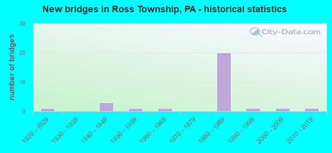
- New bridges - historical statistics
- 11920-1929
- 31940-1949
- 11950-1959
- 11960-1969
- 201980-1989
- 11990-1999
- 12000-2009
- 12010-2019
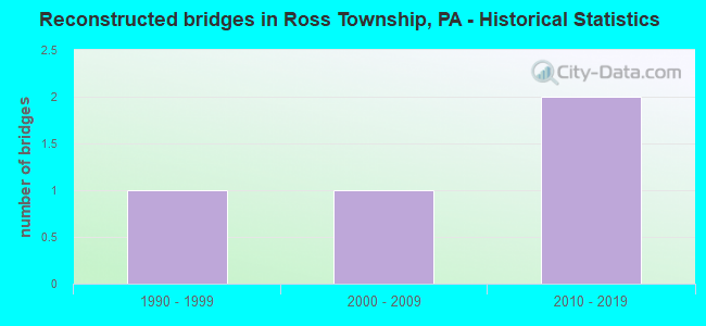
- Reconstructed bridges - Historical Statistics
- 11990-1999
- 12000-2009
- 22010-2019
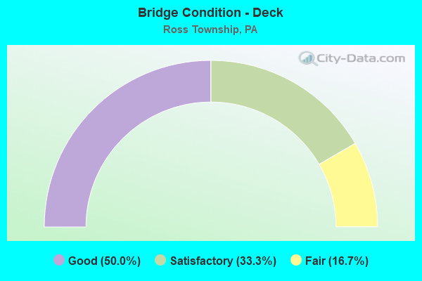
- Bridge Condition - Deck
- 50.0%Good
- 33.3%Satisfactory
- 16.7%Fair
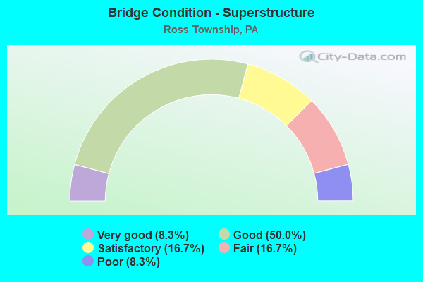
- Bridge Condition - Superstructure
- 8.3%Very good
- 50.0%Good
- 16.7%Satisfactory
- 16.7%Fair
- 8.3%Poor
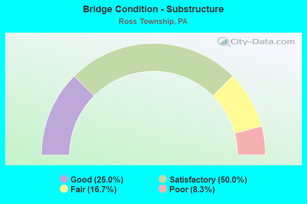
- Bridge Condition - Substructure
- 25.0%Good
- 50.0%Satisfactory
- 16.7%Fair
- 8.3%Poor
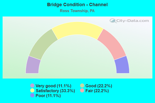
- Bridge Condition - Channel
- 11.1%Very good
- 22.2%Good
- 33.3%Satisfactory
- 22.2%Fair
- 11.1%Poor
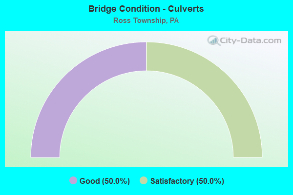
- Bridge Condition - Culverts
- 50.0%Good
- 50.0%Satisfactory
Find on map >> Show street view
Structure Number: 1086, Location: OVER SR 4014 (Lat: 40.520056, Lng: -80.061081), Route carried "on" structure: Interstate 279, Year Built: 1988, Year Reconstructed: 2018, Status: Open, Structure Length: 4.33m (14.21ft), Average Daily Traffic: 28,966 (year 2021), Truck Traffic: 7%, Average Future Daily Traffic: 23,342 (year 2032), Design Load: HS 20, Features Intersected: SR 4014, GASS RD
Minimum Vertical Clearance: 30+ m (98+ ft), Kilometerpoint: 12.070, Lanes on structure: 2, Lanes under structure: 2, Base Highway Network: Yes, Owner: State Highway Agency, Approaching Roadway Width: 13.4m (44.0ft), Skew: 12 degrees, Material/Design: Prestressed concrete, Design/Construction: Box Beam or Girders - Single/Spread, Number Of Spans In Main Unit: 3, Length of Maximum Span: 19.2m (63.0ft), Curb or Sidewalk Widths: Left: 0.2m (0.7ft), Right: 0.2m (0.7ft), Curb-To-Curb Width: 13.4m (44.0ft), Out-to-Out Width: 14.6m (47.9ft)
Condition: Deck: Satisfactory, Superstructure: Good, Substructure: Satisfactory, Operating Rating: 53.5 metric tons, Method Used To Determine Operating Rating: Load Factor (LF), Inventory Rating: 31.8 metric tons, Method Used To Determine Inventory Rating: Load Factor (LF), Structural Evaluation: Equal to present minimum criteria, Deck Geometry: Superior to present desirable criteria, Underclear: Equal to present minimum criteria, Approach Roadway Alignment: Equal to present desirable criteria, Length Of Structure Improvement: 4.30m (14.11ft), Designated Inspection Frequency: Every 24 months, Inspection Date: April 2020, Deck Structure Type: Concrete Cast-file-Place, Wearing Surface/Protective System: Wearing Surface: Monolithic Concrete, Deck Protection: Epoxy Coated Reinforcing
Find on map >> Show street view
Structure Number: 191, Location: @ INTER.W/BRAUNLICH DR. (Lat: 40.529472, Lng: -80.008794), Route carried "on" structure: US 19T, Year Built: 1946, Status: Open, Structure Length: 1.04m (3.41ft), Average Daily Traffic: 39,652 (year 2021), Truck Traffic: 2%, Average Future Daily Traffic: 44,434 (year 2032), Design Load: HS 20, Features Intersected: MCKNIGHT RUN, Facility Carried by Structure: MCKNIGHT RD
Minimum Vertical Clearance: 30+ m (98+ ft), Kilometerpoint: 4.355, Lanes on structure: 8, Base Highway Network: Yes, Owner: State Highway Agency, Approaching Roadway Width: 25.6m (84.0ft), Skew: 26 degrees, Material/Design: Concrete, Design/Construction: Culvert, Number Of Spans In Main Unit: 1, Length of Maximum Span: 10.4m (34.1ft)
Condition: Channel: Satisfactory, Culverts: Satisfactory, Inventory Rating: 76.2 metric tons, Method Used To Determine Inventory Rating: Load Factor (LF), Structural Evaluation: Equal to present minimum criteria, Waterway Adequacy: Equal to present minimum criteria, Approach Roadway Alignment: Equal to present desirable criteria, Length Of Structure Improvement: 1.70m (5.58ft), Designated Inspection Frequency: Every 24 months, Inspection Date: Febuary 2020
Find on map >> Show street view
Structure Number: 1928, Location: 738' SOUTHEAST OF SR 4011 (Lat: 40.504525, Lng: -79.988742), Route carried "on" structure: State highway , Year Built: 1929, Year Reconstructed: 1998, Status: Open, Structure Length: 1.31m (4.30ft), Average Daily Traffic: 11,703 (year 2021), Truck Traffic: 6%, Average Future Daily Traffic: 17,328 (year 2032), Design Load: HS 20, Features Intersected: GIRTYS RUN, Facility Carried by Structure: BABCOCK BL
Minimum Vertical Clearance: 30+ m (98+ ft), Kilometerpoint: 4.252, Lanes on structure: 2, Base Highway Network: Yes, Owner: State Highway Agency, Approaching Roadway Width: 11.0m (36.1ft), Skew: 1 degrees, Material/Design: Prestressed concrete, Design/Construction: Box Beam or Girders - Single/Spread, Number Of Spans In Main Unit: 1, Length of Maximum Span: 11.9m (39.0ft), Curb or Sidewalk Widths: Left: 0.2m (0.7ft), Right: 0.2m (0.7ft), Curb-To-Curb Width: 10.8m (35.4ft), Out-to-Out Width: 11.9m (39.0ft)
Condition: Deck: Good, Superstructure: Good, Substructure: Good, Channel: Fair, Operating Rating: 51.7 metric tons, Method Used To Determine Operating Rating: Load Factor (LF), Inventory Rating: 30.8 metric tons, Method Used To Determine Inventory Rating: Load Factor (LF), Structural Evaluation: Better than present minimum criteria, Deck Geometry: Meets minimum limits, Waterway Adequacy: Equal to present minimum criteria, Approach Roadway Alignment: Equal to present desirable criteria, Length Of Structure Improvement: 2.00m (6.56ft), Designated Inspection Frequency: Every 24 months, Inspection Date: Febuary 2020, Deck Structure Type: Concrete Cast-file-Place, Wearing Surface/Protective System: Wearing Surface: Monolithic Concrete, Deck Protection: Epoxy Coated Reinforcing
Find on map >> Show street view
Structure Number: 1929, Location: 200' SOUTHEAST OF SR 4011 (Lat: 40.505511, Lng: -79.990181), Route carried "on" structure: State highway , Year Built: 1998, Status: Open, Structure Length: 1.01m (3.31ft), Average Daily Traffic: 11,703 (year 2021), Truck Traffic: 6%, Average Future Daily Traffic: 17,328 (year 2032), Design Load: HS 20, Features Intersected: GIRTYS RUN, Facility Carried by Structure: BABCOCK BL
Minimum Vertical Clearance: 30+ m (98+ ft), Kilometerpoint: 4.252, Lanes on structure: 2, Base Highway Network: Yes, Owner: State Highway Agency, Approaching Roadway Width: 12.2m (40.0ft), Skew: 1 degrees, Material/Design: Prestressed concrete, Design/Construction: Box Beam or Girders - Single/Spread, Number Of Spans In Main Unit: 1, Length of Maximum Span: 9.1m (29.9ft), Curb or Sidewalk Widths: Left: 0.2m (0.7ft), Right: 0.2m (0.7ft), Curb-To-Curb Width: 12.0m (39.4ft), Out-to-Out Width: 13.4m (44.0ft)
Condition: Deck: Good, Superstructure: Very good, Substructure: Satisfactory, Channel: Satisfactory, Operating Rating: 50.8 metric tons, Method Used To Determine Operating Rating: Load Factor (LF), Inventory Rating: 29.9 metric tons, Method Used To Determine Inventory Rating: Load Factor (LF), Structural Evaluation: Equal to present minimum criteria, Deck Geometry: Somewhat better than minimum adequacy, Waterway Adequacy: Equal to present minimum criteria, Approach Roadway Alignment: Equal to present minimum criteria, Length Of Structure Improvement: 1.00m (3.28ft), Designated Inspection Frequency: Every 24 months, Inspection Date: Febuary 2020, Deck Structure Type: Concrete Cast-file-Place, Wearing Surface/Protective System: Wearing Surface: Monolithic Concrete, Deck Protection: Epoxy Coated Reinforcing
Find on map >> Show street view
Structure Number: 193, Location: 750' WEST OF SR 4011 (Lat: 40.505897, Lng: -79.992161), Route carried "on" structure: State highway , Year Built: 1963, Status: Open, Structure Length: 0.73m (2.40ft), Average Daily Traffic: 8,894 (year 2022), Truck Traffic: 6%, Average Future Daily Traffic: 14,364 (year 2032), Design Load: HS 20, Features Intersected: BR.GIRTYS RUN, Facility Carried by Structure: PEOPLES RD
Minimum Vertical Clearance: 30+ m (98+ ft), Kilometerpoint: 4.899, Lanes on structure: 4, Owner: State Highway Agency, Approaching Roadway Width: 14.0m (45.9ft), Skew: 3 degrees, Material/Design: Concrete, Design/Construction: Slab, Number Of Spans In Main Unit: 1, Length of Maximum Span: 5.8m (19.0ft), Curb or Sidewalk Widths: Left: 0.5m (1.6ft), Right: 1.5m (4.9ft), Curb-To-Curb Width: 14.0m (45.9ft), Out-to-Out Width: 16.8m (55.1ft)
Condition: Deck: Fair, Superstructure: Fair, Substructure: Satisfactory, Channel: Poor, Operating Rating: 51.7 metric tons, Method Used To Determine Operating Rating: Load Factor (LF), Inventory Rating: 30.8 metric tons, Method Used To Determine Inventory Rating: Load Factor (LF), Structural Evaluation: Somewhat better than minimum adequacy, Deck Geometry: High priority of replacement, Waterway Adequacy: Equal to present minimum criteria, Approach Roadway Alignment: Equal to present desirable criteria, Length Of Structure Improvement: 0.70m (2.30ft), Designated Inspection Frequency: Every 24 months, Inspection Date: Febuary 2020, Bridge Improvement Cost: $9,000, Roadway Improvement Cost: $26,000, Total Project Cost: $120,000, Deck Structure Type: Concrete Cast-file-Place, Wearing Surface/Protective System: Wearing Surface: Monolithic Concrete
Find on map >> Show street view
Structure Number: 1943, Location: UNION AVE. OVER I-279 (Lat: 40.516361, Lng: -80.053456), Route carried "on" structure: State highway , Year Built: 1987, Status: Open, Structure Length: 12.74m (41.80ft), Average Daily Traffic: 8,124 (year 2022), Truck Traffic: 3%, Average Future Daily Traffic: 49,042 (year 2032), Design Load: HS 20, Features Intersected: I-279 NB&SB, Facility Carried by Structure: UNION AV
Minimum Vertical Clearance: 30+ m (98+ ft), Kilometerpoint: 2.894, Lanes on structure: 2, Lanes under structure: 12, Owner: State Highway Agency, Approaching Roadway Width: 17.7m (58.1ft), Skew: 25 degrees, Material/Design: Steel continuous, Design/Construction: Stringer/Multi-beam, Number Of Spans In Main Unit: 2, Length of Maximum Span: 76.8m (252.0ft), Curb or Sidewalk Widths: Left: 0.2m (0.7ft), Right: 0.2m (0.7ft), Curb-To-Curb Width: 17.7m (58.1ft), Out-to-Out Width: 18.7m (61.4ft)
Condition: Deck: Satisfactory, Superstructure: Good, Substructure: Satisfactory, Operating Rating: 54.4 metric tons, Method Used To Determine Operating Rating: Load Factor (LF), Inventory Rating: 32.7 metric tons, Method Used To Determine Inventory Rating: Load Factor (LF), Structural Evaluation: Equal to present minimum criteria, Deck Geometry: Superior to present desirable criteria, Underclear: Somewhat better than minimum adequacy, Approach Roadway Alignment: Equal to present desirable criteria, Length Of Structure Improvement: 12.70m (41.67ft), Designated Inspection Frequency: Every 24 months, Inspection Date: April 2020, Deck Structure Type: Concrete Cast-file-Place, Wearing Surface/Protective System: Wearing Surface: Monolithic Concrete, Deck Protection: Epoxy Coated Reinforcing
Find on map >> Show street view
Structure Number: 199, Location: LR 246 SPUR C1 OVER 1021 (Lat: 40.502914, Lng: -80.026539), Route carried "on" structure: State highway , Year Built: 1986, Status: Open, Structure Length: 8.11m (26.61ft), Average Daily Traffic: 15,556 (year 2022), Truck Traffic: 5%, Average Future Daily Traffic: 18,268 (year 2032), Design Load: HS 20, Features Intersected: LR 1021-4 NB SB HOV I279, Facility Carried by Structure: PERRYSVILLE AVE RP
Minimum Vertical Clearance: 30+ m (98+ ft), Kilometerpoint: 0.000, Lanes on structure: 2, Lanes under structure: 6, Owner: State Highway Agency, Approaching Roadway Width: 14.9m (48.9ft), Material/Design: Prestressed concrete, Design/Construction: Stringer/Multi-beam, Number Of Spans In Main Unit: 3, Length of Maximum Span: 27.7m (90.9ft), Curb-To-Curb Width: 14.8m (48.6ft), Out-to-Out Width: 15.7m (51.5ft)
Condition: Deck: Satisfactory, Superstructure: Satisfactory, Substructure: Satisfactory, Inventory Rating: 62.6 metric tons, Method Used To Determine Inventory Rating: Load Factor (LF), Structural Evaluation: Equal to present minimum criteria, Deck Geometry: Superior to present desirable criteria, Underclear: High priority of corrective action, Approach Roadway Alignment: Equal to present desirable criteria, Length Of Structure Improvement: 8.10m (26.57ft), Designated Inspection Frequency: Every 24 months, Inspection Date: April 2020, Deck Structure Type: Concrete Cast-file-Place, Wearing Surface/Protective System: Wearing Surface: Monolithic Concrete, Deck Protection: Epoxy Coated Reinforcing
Find on map >> Show street view
Structure Number: 2201, Location: 116003 ROSS TOWNSHIP (Lat: 40.513611, Lng: -80.003028), Route carried "on" structure: City street , Year Built: 1950, Year Reconstructed: 2019, Status: Open, Structure Length: 1.80m (5.91ft), Average Daily Traffic: 400 (year 2019), Truck Traffic: 5%, Average Future Daily Traffic: 470 (year 2041), Design Load: HL 93, Features Intersected: GIRTYS RUN, Facility Carried by Structure: BROOKVIEW LN
Minimum Vertical Clearance: 30+ m (98+ ft), Kilometerpoint: 0.000, Lanes on structure: 2, Owner: Town or Township Highway Agency, Approaching Roadway Width: 7.0m (23.0ft), Material/Design: Steel, Design/Construction: Stringer/Multi-beam, Number Of Spans In Main Unit: 1, Number Of Approach Spans: 2, Length of Maximum Span: 8.5m (27.9ft), Curb-To-Curb Width: 7.6m (24.9ft), Out-to-Out Width: 8.2m (26.9ft)
Condition: Deck: Good, Superstructure: Good, Substructure: Fair, Channel: Fair, Operating Rating: 48.6 metric tons, Method Used To Determine Operating Rating: Assigned ratings based on Load and Resistance Factor Design (LRFD) reported by rating factor (RF) using HL93 loadings, Inventory Rating: 37.3 metric tons, Method Used To Determine Inventory Rating: Assigned ratings based on Load and Resistance Factor Design (LRFD) reported by rating factor (RF) using HL93 loadings, Structural Evaluation: Somewhat better than minimum adequacy, Deck Geometry: Somewhat better than minimum adequacy, Waterway Adequacy: Better than present minimum criteria, Approach Roadway Alignment: Equal to present desirable criteria, Length Of Structure Improvement: 1.80m (5.91ft), Designated Inspection Frequency: Every 24 months, Inspection Date: June 2021, Deck Structure Type: Concrete Cast-file-Place, Wearing Surface/Protective System: Wearing Surface: Monolithic Concrete, Deck Protection: Epoxy Coated Reinforcing
Find on map >> Show street view
Structure Number: 2202, Location: PD03 JACKS RUN NO. 3 (Lat: 40.507136, Lng: -80.037097), Route carried "on" structure: County highway , Year Built: 1986, Status: Open, Structure Length: 6.25m (20.51ft), Average Daily Traffic: 4,631 (year 2006), Truck Traffic: 5%, Average Future Daily Traffic: 6,000 (year 2028), Design Load: HS 25 or greater, Features Intersected: SR0279, Facility Carried by Structure: JACKS RUN RD
Minimum Vertical Clearance: 30+ m (98+ ft), Kilometerpoint: 0.000, Lanes on structure: 2, Lanes under structure: 8, Owner: County Highway Agency, Approaching Roadway Width: 7.3m (24.0ft), Material/Design: Prestressed concrete, Design/Construction: Stringer/Multi-beam, Number Of Spans In Main Unit: 1, Number Of Approach Spans: 1, Length of Maximum Span: 40.5m (132.9ft), Curb or Sidewalk Widths: Left: 1.7m (5.6ft), Right: 0.2m (0.7ft), Curb-To-Curb Width: 9.8m (32.2ft), Out-to-Out Width: 12.8m (42.0ft)
Condition: Deck: Satisfactory, Superstructure: Fair, Substructure: Poor, Operating Rating: 84.4 metric tons, Method Used To Determine Operating Rating: Load Factor (LF), Inventory Rating: 40.8 metric tons, Method Used To Determine Inventory Rating: Load Factor (LF), Structural Evaluation: Meets minimum limits, Deck Geometry: Meets minimum limits, Underclear: Superior to present desirable criteria, Approach Roadway Alignment: Somewhat better than minimum adequacy, Length Of Structure Improvement: 6.30m (20.67ft), Designated Inspection Frequency: Every 24 months, Inspection Date: June 2020, Deck Structure Type: Concrete Cast-file-Place, Wearing Surface/Protective System: Wearing Surface: Monolithic Concrete, Deck Protection: Epoxy Coated Reinforcing
Find on map >> Show street view
Structure Number: 2203, Location: PD04 BELLEVUE RD BRIDGE (Lat: 40.507325, Lng: -80.039222), Route carried "on" structure: County highway , Year Built: 1988, Status: Open, Structure Length: 7.62m (25.00ft), Average Daily Traffic: 3,523 (year 2006), Truck Traffic: 5%, Average Future Daily Traffic: 5,000 (year 2026), Design Load: HS 20, Features Intersected: SR 0279, Facility Carried by Structure: BELLEVUE RD
Minimum Vertical Clearance: 30+ m (98+ ft), Kilometerpoint: 0.000, Lanes on structure: 2, Lanes under structure: 8, Owner: County Highway Agency, Approaching Roadway Width: 9.4m (30.8ft), Skew: 4 degrees, Material/Design: Steel, Design/Construction: Stringer/Multi-beam, Number Of Spans In Main Unit: 1, Number Of Approach Spans: 1, Length of Maximum Span: 53.9m (176.8ft), Curb or Sidewalk Widths: Left: 1.7m (5.6ft), Right: 0.2m (0.7ft), Curb-To-Curb Width: 9.8m (32.2ft), Out-to-Out Width: 12.8m (42.0ft)
Condition: Deck: Good, Superstructure: Good, Substructure: Satisfactory, Operating Rating: 89.8 metric tons, Method Used To Determine Operating Rating: Load Factor (LF), Inventory Rating: 55.3 metric tons, Method Used To Determine Inventory Rating: Load Factor (LF), Structural Evaluation: Equal to present minimum criteria, Deck Geometry: Meets minimum limits, Underclear: Superior to present desirable criteria, Approach Roadway Alignment: Equal to present minimum criteria, Length Of Structure Improvement: 7.60m (24.93ft), Designated Inspection Frequency: Every 24 months, Inspection Date: June 2020, Deck Structure Type: Concrete Cast-file-Place, Wearing Surface/Protective System: Wearing Surface: Monolithic Concrete, Deck Protection: Epoxy Coated Reinforcing
Find on map >> Show street view
Structure Number: 2204, Location: PS10 PINE CRK # 10,S BR (Lat: 40.552108, Lng: -79.999642), Route carried "on" structure: County highway , Year Built: 1941, Status: Open, Structure Length: 1.13m (3.71ft), Average Daily Traffic: 1,520 (year 2006), Truck Traffic: 5%, Average Future Daily Traffic: 1,520 (year 2026), Design Load: HS 20, Features Intersected: PINE CREEK,SOUTH BRANCH, Facility Carried by Structure: MCINTYRE RD
Minimum Vertical Clearance: 30+ m (98+ ft), Kilometerpoint: 0.000, Lanes on structure: 2, Owner: County Highway Agency, Approaching Roadway Width: 7.3m (24.0ft), Material/Design: Concrete, Design/Construction: Tee Beam, Number Of Spans In Main Unit: 1, Length of Maximum Span: 10.1m (33.1ft), Curb-To-Curb Width: 7.7m (25.3ft), Out-to-Out Width: 8.3m (27.2ft)
Condition: Deck: Fair, Superstructure: Poor, Substructure: Fair, Channel: Satisfactory, Operating Rating: 43.5 metric tons, Method Used To Determine Operating Rating: Load Factor (LF), Inventory Rating: 26.3 metric tons, Method Used To Determine Inventory Rating: Load Factor (LF), Structural Evaluation: Meets minimum limits, Deck Geometry: Meets minimum limits, Waterway Adequacy: Better than present minimum criteria, Approach Roadway Alignment: Equal to present desirable criteria, Length Of Structure Improvement: 1.10m (3.61ft), Designated Inspection Frequency: Every 24 months, Inspection Date: August 2020, Bridge Improvement Cost: $6,000, Roadway Improvement Cost: $17,000, Total Project Cost: $79,000, Deck Structure Type: Concrete Cast-file-Place, Wearing Surface/Protective System: Wearing Surface: Bituminous
Find on map >> Show street view
Structure Number: 2205, Location: GI14 GIRTYS RUN NO. 14 (Lat: 40.515692, Lng: -80.009928), Route carried "on" structure: Alternate County highway , Year Built: 2005, Status: Open, Structure Length: 0.61m (2.00ft), Average Daily Traffic: 4,408 (year 2006), Truck Traffic: 5%, Average Future Daily Traffic: 5,487 (year 2025), Design Load: HS 25 or greater, Features Intersected: GIRTYS RUN, Facility Carried by Structure: CEMETERY LN
Minimum Vertical Clearance: 30+ m (98+ ft), Kilometerpoint: 0.000, Lanes on structure: 3, Owner: County Highway Agency, Approaching Roadway Width: 13.4m (44.0ft), Skew: 1 degrees, Material/Design: Concrete, Design/Construction: Culvert, Number Of Spans In Main Unit: 1, Length of Maximum Span: 6.1m (20.0ft), Curb or Sidewalk Widths: Left: 0.2m (0.7ft), Right: 0.2m (0.7ft), Curb-To-Curb Width: 17.0m (55.8ft), Out-to-Out Width: 17.9m (58.7ft)
Condition: Channel: Good, Culverts: Good, Operating Rating: 89.8 metric tons, Method Used To Determine Operating Rating: Load Factor (LF), Inventory Rating: 75.3 metric tons, Method Used To Determine Inventory Rating: Load Factor (LF), Structural Evaluation: Better than present minimum criteria, Deck Geometry: Superior to present desirable criteria, Waterway Adequacy: Superior to present desirable criteria, Approach Roadway Alignment: Equal to present desirable criteria, Length Of Structure Improvement: 0.60m (1.97ft), Designated Inspection Frequency: Every 24 months, Inspection Date: June 2020
Find on map >> Show street view
Structure Number: 2206, Location: XP05 LEVI BIRD DUFF BRG (Lat: 40.508881, Lng: -80.046678), Route carried "on" structure: County highway , Year Built: 1983, Year Reconstructed: 2013, Status: Open, Structure Length: 25.30m (83.01ft), Average Daily Traffic: 5,500 (year 2005), Truck Traffic: 5%, Average Future Daily Traffic: 7,000 (year 2025), Design Load: HS 20, Features Intersected: I-279 PKWY N,SPRUCE RUN, Facility Carried by Structure: CORNELL AV
Minimum Vertical Clearance: 30+ m (98+ ft), Kilometerpoint: 0.000, Lanes on structure: 2, Lanes under structure: 8, Owner: County Highway Agency, Approaching Roadway Width: 9.8m (32.2ft), Material/Design: Steel continuous, Design/Construction: Stringer/Multi-beam, Number Of Spans In Main Unit: 4, Number Of Approach Spans: 1, Length of Maximum Span: 61.0m (200.1ft), Curb or Sidewalk Widths: Left: 1.8m (5.9ft), Right: 0.2m (0.7ft), Curb-To-Curb Width: 9.8m (32.2ft), Out-to-Out Width: 12.6m (41.3ft)
Condition: Deck: Good, Superstructure: Satisfactory, Substructure: Good, Channel: Very good, Operating Rating: 64.4 metric tons, Method Used To Determine Operating Rating: Load Factor (LF), Inventory Rating: 38.1 metric tons, Method Used To Determine Inventory Rating: Load Factor (LF), Structural Evaluation: Equal to present minimum criteria, Deck Geometry: Meets minimum limits, Underclear: Superior to present desirable criteria, Waterway Adequacy: Superior to present desirable criteria, Approach Roadway Alignment: Equal to present desirable criteria, Length Of Structure Improvement: 25.30m (83.01ft), Designated Inspection Frequency: Every 24 months, Inspection Date: September 2021, Bridge Improvement Cost: $77,000, Roadway Improvement Cost: $227,000, Total Project Cost: $1,042,000, Deck Structure Type: Concrete Cast-file-Place, Wearing Surface/Protective System: Wearing Surface: Latex Concrete, Deck Protection: Epoxy Coated Reinforcing
Find on map >> Show street view
Structure Number: 4727, Location: PS01 PINE CREEK, SOUTH BR (Lat: 40.549667, Lng: -79.997758), Route carried "on" structure: County highway , Year Built: 2012, Status: Open, Structure Length: 1.22m (4.00ft), Average Daily Traffic: 16,520 (year 2005), Truck Traffic: 2%, Average Future Daily Traffic: 20,000 (year 2025), Design Load: HL 93, Features Intersected: PINE CREEK SOUTH, Facility Carried by Structure: THOMPSON RUN RD
Minimum Vertical Clearance: 30+ m (98+ ft), Kilometerpoint: 0.000, Lanes on structure: 2, Owner: County Highway Agency, Approaching Roadway Width: 9.4m (30.8ft), Skew: 4 degrees, Material/Design: Prestressed concrete, Design/Construction: Box Beam or Girders - Single/Spread, Number Of Spans In Main Unit: 1, Length of Maximum Span: 12.2m (40.0ft), Curb or Sidewalk Widths: Left: 0.2m (0.7ft), Right: 0.2m (0.7ft), Curb-To-Curb Width: 10.1m (33.1ft), Out-to-Out Width: 11.1m (36.4ft)
Condition: Deck: Good, Superstructure: Good, Substructure: Good, Channel: Good, Operating Rating: 52.2 metric tons, Method Used To Determine Operating Rating: Assigned ratings based on Load and Resistance Factor Design (LRFD) reported by rating factor (RF) using HL93 loadings, Inventory Rating: 32.7 metric tons, Method Used To Determine Inventory Rating: Assigned ratings based on Load and Resistance Factor Design (LRFD) reported by rating factor (RF) using HL93 loadings, Structural Evaluation: Better than present minimum criteria, Deck Geometry: Meets minimum limits, Waterway Adequacy: Equal to present desirable criteria, Approach Roadway Alignment: Equal to present desirable criteria, Designated Inspection Frequency: Every 24 months, Inspection Date: June 2020, Deck Structure Type: Concrete Cast-file-Place, Wearing Surface/Protective System: Wearing Surface: Monolithic Concrete, Deck Protection: Epoxy Coated Reinforcing
Find on map >> Show street view
Structure Number: 1078, Location: OVER HOV LANE @ PARK&RIDE (Lat: 40.505856, Lng: -80.030931), Route carried "under" structure: Interstate 279, Year Built: 1987, Structure Length: 0. m, Average Daily Traffic: 103 (year 2021), Truck Traffic: 6%, Features Intersected: I-279 - HOV LANE, Facility Carried by Structure: RAYMOND E WILT HW
Minimum Vertical Clearance: 4.93m (16.17ft), Kilometerpoint: 7.495, Lanes on structure: 3, Lanes under structure: 1, Material/Design: Prestressed concrete, Design/Construction: Stringer/Multi-beam, Length of Maximum Span: 27.4m (89.9ft)
Find on map >> Show street view
Structure Number: 1086, Location: OVER SR 4014 (Lat: 40.520056, Lng: -80.061081), Route carried "under" structure: State highway , Year Built: 1988, Structure Length: 0. m, Average Daily Traffic: 3,944 (year 2022), Truck Traffic: 1%, Features Intersected: SR 4014, GASS RD, Facility Carried by Structure: SR 0279 NB
Minimum Vertical Clearance: 4.65m (15.26ft), Kilometerpoint: 0.000, Lanes on structure: 2, Lanes under structure: 2, Material/Design: Prestressed concrete, Design/Construction: Box Beam or Girders - Single/Spread, Length of Maximum Span: 19.2m (63.0ft)
Find on map >> Show street view
Structure Number: 1088, Location: OVER LR 02089 (Lat: 40.519833, Lng: -80.061264), Route carried "under" structure: State highway , Year Built: 1988, Structure Length: 0. m, Average Daily Traffic: 3,944 (year 2022), Truck Traffic: 1%, Features Intersected: SR 4014, GASS RD, Facility Carried by Structure: RAYMOND E WILT HW
Minimum Vertical Clearance: 4.95m (16.24ft), Kilometerpoint: 0.000, Lanes on structure: 3, Lanes under structure: 2, Material/Design: Prestressed concrete, Design/Construction: Box Beam or Girders - Single/Spread, Length of Maximum Span: 21.6m (70.9ft)
Find on map >> Show street view
Structure Number: 1904, Location: OVER 02328 & GIRTY'S RUN (Lat: 40.522000, Lng: -80.005506), Route carried "under" structure: State highway , Year Built: 1946, Structure Length: 0. m, Average Daily Traffic: 16,480 (year 2021), Truck Traffic: 7%, Features Intersected: BABCOCK BLVD,GIRDY'S RUN, Facility Carried by Structure: MCKNIGHT RD
Minimum Vertical Clearance: 11.79m (38.68ft), Kilometerpoint: 0.776, Lanes on structure: 4, Lanes under structure: 4, Material/Design: Concrete continuous, Design/Construction: Tee Beam, Length of Maximum Span: 21.3m (69.9ft)
Find on map >> Show street view
Structure Number: 1943, Location: UNION AVE. OVER I-279 (Lat: 40.516361, Lng: -80.053456), Route carried "under" structure: Interstate 279, Year Built: 1987, Structure Length: 0. m, Average Daily Traffic: 31,475 (year 2021), Truck Traffic: 8%, Features Intersected: I-279 NB&SB, Facility Carried by Structure: UNION AV
Minimum Vertical Clearance: 6.10m (20.01ft), Kilometerpoint: 11.132, Lanes on structure: 2, Lanes under structure: 6, Material/Design: Steel continuous, Design/Construction: Stringer/Multi-beam, Length of Maximum Span: 76.8m (252.0ft)
Find on map >> Show street view
Structure Number: 1943, Location: UNION AVE. OVER I-279 (Lat: 40.516361, Lng: -80.053456), Route carried "under" structure: Interstate 279, Year Built: 1987, Structure Length: 0. m, Average Daily Traffic: 28,966 (year 2021), Truck Traffic: 7%, Features Intersected: I-279 NB&SB, Facility Carried by Structure: UNION AV
Minimum Vertical Clearance: 6.10m (20.01ft), Kilometerpoint: 11.265, Lanes on structure: 2, Lanes under structure: 6, Material/Design: Steel continuous, Design/Construction: Stringer/Multi-beam, Length of Maximum Span: 76.8m (252.0ft)
Find on map >> Show street view
Structure Number: 199, Location: LR 246 SPUR C1 OVER 1021 (Lat: 40.502914, Lng: -80.026539), Route carried "under" structure: Interstate 279, Year Built: 1986, Structure Length: 0. m, Average Daily Traffic: 25,504 (year 2020), Truck Traffic: 5%, Features Intersected: LR 1021-4 NB SB HOV I279, Facility Carried by Structure: PERRYSVILLE AVE RP
Minimum Vertical Clearance: 5.31m (17.42ft), Kilometerpoint: 7.905, Lanes on structure: 2, Lanes under structure: 2, Material/Design: Prestressed concrete, Design/Construction: Stringer/Multi-beam, Length of Maximum Span: 27.7m (90.9ft)
Find on map >> Show street view
Structure Number: 199, Location: LR 246 SPUR C1 OVER 1021 (Lat: 40.502914, Lng: -80.026539), Route carried "under" structure: Interstate 279, Year Built: 1986, Structure Length: 0. m, Average Daily Traffic: 103 (year 2021), Truck Traffic: 6%, Features Intersected: LR 1021-4 NB SB HOV I279, Facility Carried by Structure: PERRYSVILLE AVE RP
Minimum Vertical Clearance: 4.57m (14.99ft), Kilometerpoint: 7.495, Lanes on structure: 2, Lanes under structure: 2, Material/Design: Prestressed concrete, Design/Construction: Stringer/Multi-beam, Length of Maximum Span: 27.7m (90.9ft)
Find on map >> Show street view
Structure Number: 199, Location: LR 246 SPUR C1 OVER 1021 (Lat: 40.502914, Lng: -80.026539), Route carried "under" structure: Interstate 279, Year Built: 1986, Structure Length: 0. m, Average Daily Traffic: 25,917 (year 2020), Truck Traffic: 4%, Features Intersected: LR 1021-4 NB SB HOV I279, Facility Carried by Structure: PERRYSVILLE AVE RP
Minimum Vertical Clearance: 5.31m (17.42ft), Kilometerpoint: 8.047, Lanes on structure: 2, Lanes under structure: 2, Material/Design: Prestressed concrete, Design/Construction: Stringer/Multi-beam, Length of Maximum Span: 27.7m (90.9ft)
Find on map >> Show street view
Structure Number: 2202, Location: PD03 JACKS RUN NO. 3 (Lat: 40.507136, Lng: -80.037097), Route carried "under" structure: Interstate 279, Year Built: 1986, Structure Length: 0. m, Average Daily Traffic: 25,917 (year 2020), Truck Traffic: 4%, Features Intersected: SR0279, Facility Carried by Structure: JACKS RUN RD
Minimum Vertical Clearance: 8.18m (26.84ft), Kilometerpoint: 9.656, Lanes on structure: 2, Lanes under structure: 4, Material/Design: Prestressed concrete, Design/Construction: Stringer/Multi-beam, Length of Maximum Span: 40.5m (132.9ft)
Find on map >> Show street view
Structure Number: 2202, Location: PD03 JACKS RUN NO. 3 (Lat: 40.507136, Lng: -80.037097), Route carried "under" structure: Interstate 279, Year Built: 1986, Structure Length: 0. m, Average Daily Traffic: 25,504 (year 2020), Truck Traffic: 5%, Features Intersected: SR0279, Facility Carried by Structure: JACKS RUN RD
Minimum Vertical Clearance: 8.18m (26.84ft), Kilometerpoint: 9.487, Lanes on structure: 2, Lanes under structure: 4, Material/Design: Prestressed concrete, Design/Construction: Stringer/Multi-beam, Length of Maximum Span: 40.5m (132.9ft)
Find on map >> Show street view
Structure Number: 2203, Location: PD04 BELLEVUE RD BRIDGE (Lat: 40.507325, Lng: -80.039222), Route carried "under" structure: Interstate 279, Year Built: 1988, Structure Length: 0. m, Average Daily Traffic: 25,917 (year 2020), Truck Traffic: 4%, Features Intersected: SR 0279, Facility Carried by Structure: BELLEVUE RD
Minimum Vertical Clearance: 6.35m (20.83ft), Kilometerpoint: 9.656, Lanes on structure: 2, Lanes under structure: 4, Material/Design: Steel, Design/Construction: Stringer/Multi-beam, Length of Maximum Span: 53.9m (176.8ft)
Find on map >> Show street view
Structure Number: 2203, Location: PD04 BELLEVUE RD BRIDGE (Lat: 40.507325, Lng: -80.039222), Route carried "under" structure: Interstate 279, Year Built: 1988, Structure Length: 0. m, Average Daily Traffic: 25,504 (year 2020), Truck Traffic: 5%, Features Intersected: SR 0279, Facility Carried by Structure: BELLEVUE RD
Minimum Vertical Clearance: 6.35m (20.83ft), Kilometerpoint: 9.487, Lanes on structure: 2, Lanes under structure: 4, Material/Design: Steel, Design/Construction: Stringer/Multi-beam, Length of Maximum Span: 53.9m (176.8ft)
Find on map >> Show street view
Structure Number: 2206, Location: XP05 LEVI BIRD DUFF BRG (Lat: 40.508881, Lng: -80.046678), Route carried "under" structure: Interstate 279, Year Built: 1983, Structure Length: 0. m, Average Daily Traffic: 25,917 (year 2020), Truck Traffic: 4%, Features Intersected: I-279 PKWY N,SPRUCE RUN, Facility Carried by Structure: CORNELL AV
Minimum Vertical Clearance: 13.56m (44.49ft), Kilometerpoint: 10.461, Lanes on structure: 2, Lanes under structure: 4, Material/Design: Steel continuous, Design/Construction: Stringer/Multi-beam, Length of Maximum Span: 61.0m (200.1ft)
Find on map >> Show street view
Structure Number: 2206, Location: XP05 LEVI BIRD DUFF BRG (Lat: 40.508881, Lng: -80.046678), Route carried "under" structure: Interstate 279, Year Built: 1983, Structure Length: 0. m, Average Daily Traffic: 25,504 (year 2020), Truck Traffic: 5%, Features Intersected: I-279 PKWY N,SPRUCE RUN, Facility Carried by Structure: CORNELL AV
Minimum Vertical Clearance: 13.56m (44.49ft), Kilometerpoint: 10.300, Lanes on structure: 2, Lanes under structure: 4, Material/Design: Steel continuous, Design/Construction: Stringer/Multi-beam, Length of Maximum Span: 61.0m (200.1ft)