Bridge Statistics for Rosedale, Maryland (MD)
Condition, Traffic, Stress, Structural Evaluation, Project Costs
- National Bridge Inventory (NBI) Statistics
- 37Number of bridges
- 1,877ft / 572mTotal length
- $9,397,000Total costs
- 1,490,747Total average daily traffic
- 146,433Total average daily truck traffic
- National Bridge Inventory (NBI) Registered Bridges for Rosedale
- No street view available for this location
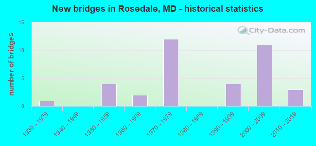
- New bridges - historical statistics
- 11930-1939
- 41950-1959
- 21960-1969
- 121970-1979
- 41990-1999
- 112000-2009
- 32010-2019

- Reconstructed bridges - Historical Statistics
- 11980-1989
- 01990-1999
- 32000-2009
- 12010-2019


- Bridge Condition - Deck
- 14.8%Very good
- 63.0%Good
- 18.5%Satisfactory
- 3.7%Fair

- Bridge Condition - Superstructure
- 33.3%Very good
- 33.3%Good
- 29.6%Satisfactory
- 3.7%Fair

- Bridge Condition - Substructure
- 18.5%Very good
- 51.9%Good
- 22.2%Satisfactory
- 7.4%Fair

- Bridge Condition - Channel
- 31.6%Very good
- 47.4%Good
- 5.3%Satisfactory
- 15.8%Fair

- Bridge Condition - Culverts
- 25.0%Good
- 50.0%Satisfactory
- 25.0%Fair
Find on map >> Show street view
Structure Number: 10000003001702, Location: 0.89 MI E OF US 40 (Lat: 39.320717, Lng: -76.514733), Route carried "on" structure: State highway 7, Year Built: 1952, Status: Open, Structure Length: 0.87m (2.85ft), Average Daily Traffic: 10,130 (year 2009), Truck Traffic: 8%, Average Future Daily Traffic: 13,063 (year 2026), Design Load: H 20, Features Intersected: REDHOUSE CREEK
Minimum Vertical Clearance: 30+ m (98+ ft), Kilometerpoint: 1.432, Lanes on structure: 2, Owner: State Highway Agency, Approaching Roadway Width: 9.1m (29.9ft), Skew: 2 degrees, Material/Design: Concrete, Design/Construction: Culvert, Length of Maximum Span: 4.3m (14.1ft)
Condition: Channel: Fair, Culverts: Satisfactory, Operating Rating: 73.5 metric tons, Method Used To Determine Operating Rating: Allowable Stress (AS), Inventory Rating: 50.8 metric tons, Method Used To Determine Inventory Rating: Allowable Stress (AS), Structural Evaluation: Equal to present minimum criteria, Waterway Adequacy: Equal to present minimum criteria, Approach Roadway Alignment: Equal to present desirable criteria, Designated Inspection Frequency: Every 24 months, Inspection Date: June 2020
Find on map >> Show street view
Structure Number: 10000003004001, Location: 0.65 MI E OF MD 7 (Lat: 39.316900, Lng: -76.515911), Route carried "on" structure: US 40, Year Built: 1935, Status: Open, Structure Length: 1.25m (4.10ft), Average Daily Traffic: 37,450 (year 2009), Truck Traffic: 8%, Average Future Daily Traffic: 40,297 (year 2026), Design Load: H 20, Features Intersected: REDHOUSE CREEK
Minimum Vertical Clearance: 30+ m (98+ ft), Kilometerpoint: 24.006, Lanes on structure: 4, Base Highway Network: Yes, Owner: State Highway Agency, Approaching Roadway Width: 28.7m (94.2ft), Skew: 3 degrees, Material/Design: Concrete, Design/Construction: Tee Beam, Number Of Spans In Main Unit: 1, Length of Maximum Span: 11.0m (36.1ft), Curb-To-Curb Width: 24.4m (80.1ft), Out-to-Out Width: 25.5m (83.7ft)
Condition: Deck: Fair, Superstructure: Good, Substructure: Fair, Channel: Fair, Operating Rating: 89.8 metric tons, Method Used To Determine Operating Rating: Load Factor (LF), Inventory Rating: 54.0 metric tons, Method Used To Determine Inventory Rating: Load Factor (LF), Structural Evaluation: Somewhat better than minimum adequacy, Deck Geometry: Superior to present desirable criteria, Waterway Adequacy: Better than present minimum criteria, Approach Roadway Alignment: Equal to present desirable criteria, Length Of Structure Improvement: 1.25m (4.10ft), Designated Inspection Frequency: Every 24 months, Inspection Date: June 2021, Bridge Improvement Cost: $206,000, Roadway Improvement Cost: $21,000, Total Project Cost: $227,000, Deck Structure Type: Concrete Cast-file-Place, Wearing Surface/Protective System: Wearing Surface: Bituminous
Find on map >> Show street view
Structure Number: 100000030238015, Location: 0.75 MILE SOUTH OF MD 150 (Lat: 39.308158, Lng: -76.501497), Route carried "on" structure: State highway 695, Year Built: 1968, Status: Open, Structure Length: 65.65m (215.39ft), Average Daily Traffic: 69,922 (year 2009), Truck Traffic: 8%, Average Future Daily Traffic: 44,150 (year 2028), Design Load: HS 20, Features Intersected: AMTRAK & BACK RIVER
Minimum Vertical Clearance: 30+ m (98+ ft), Kilometerpoint: 5.438, Lanes on structure: 3, Base Highway Network: Yes, Owner: State Highway Agency, Approaching Roadway Width: 17.1m (56.1ft), Skew: 9 degrees, Material/Design: Steel, Design/Construction: Stringer/Multi-beam, Number Of Spans In Main Unit: 3, Number Of Approach Spans: 39, Length of Maximum Span: 26.2m (86.0ft), Curb-To-Curb Width: 15.4m (50.5ft), Out-to-Out Width: 16.5m (54.1ft)
Condition: Deck: Satisfactory, Superstructure: Satisfactory, Substructure: Satisfactory, Channel: Good, Operating Rating: 63.0 metric tons, Method Used To Determine Operating Rating: Load Factor (LF), Inventory Rating: 37.6 metric tons, Method Used To Determine Inventory Rating: Load Factor (LF), Structural Evaluation: Equal to present minimum criteria, Deck Geometry: Somewhat better than minimum adequacy, Underclear: Superior to present desirable criteria, Waterway Adequacy: Equal to present desirable criteria, Approach Roadway Alignment: Equal to present desirable criteria, Length Of Structure Improvement: 65.65m (215.39ft), Designated Inspection Frequency: Every 24 months, Underwater Inspection Frequency: Every 48 months, Inspection Date: March 2021, Underwater Inspection Date: August 2019, Bridge Improvement Cost: $6,979,000, Roadway Improvement Cost: $698,000, Total Project Cost: $7,677,000, Deck Structure Type: Concrete Cast-file-Place, Wearing Surface/Protective System: Wearing Surface: Monolithic Concrete
Find on map >> Show street view
Structure Number: 100000030257015, Location: 0.94 MILE SOUTH OF MD 150 (Lat: 39.310600, Lng: -76.502700), Route carried "on" structure: State highway 695, Year Built: 1970, Year Reconstructed: 2006, Status: Open, Structure Length: 4.05m (13.29ft), Average Daily Traffic: 69,922 (year 2009), Truck Traffic: 8%, Average Future Daily Traffic: 39,270 (year 2026), Design Load: HS 20, Features Intersected: CHESACO AVENUE
Minimum Vertical Clearance: 30+ m (98+ ft), Kilometerpoint: 5.163, Lanes on structure: 2, Lanes under structure: 2, Base Highway Network: Yes, Owner: State Highway Agency, Approaching Roadway Width: 11.6m (38.1ft), Skew: 2 degrees, Material/Design: Steel, Design/Construction: Stringer/Multi-beam, Number Of Spans In Main Unit: 3, Length of Maximum Span: 22.9m (75.1ft), Curb-To-Curb Width: 22.9m (75.1ft), Out-to-Out Width: 23.8m (78.1ft)
Condition: Deck: Good, Superstructure: Good, Substructure: Good, Operating Rating: 42.6 metric tons, Method Used To Determine Operating Rating: Load Factor (LF), Inventory Rating: 25.4 metric tons, Method Used To Determine Inventory Rating: Load Factor (LF), Structural Evaluation: Equal to present minimum criteria, Deck Geometry: Superior to present desirable criteria, Underclear: Meets minimum limits, Approach Roadway Alignment: Equal to present minimum criteria, Designated Inspection Frequency: Every 24 months, Inspection Date: December 2020, Deck Structure Type: Concrete Cast-file-Place, Wearing Surface/Protective System: Wearing Surface: Latex Concrete
Find on map >> Show street view
Structure Number: 100000030257016, Location: 0.94 MILE SOUTH OF MD 150 (Lat: 39.310217, Lng: -76.502111), Route carried "on" structure: State highway 695, Year Built: 1970, Status: Open, Structure Length: 4.57m (14.99ft), Average Daily Traffic: 69,922 (year 2009), Truck Traffic: 8%, Average Future Daily Traffic: 39,270 (year 2026), Design Load: HS 20, Features Intersected: CHESACO AVENUE
Minimum Vertical Clearance: 30+ m (98+ ft), Kilometerpoint: 5.163, Lanes on structure: 2, Lanes under structure: 2, Base Highway Network: Yes, Owner: State Highway Agency, Approaching Roadway Width: 11.6m (38.1ft), Skew: 2 degrees, Material/Design: Steel, Design/Construction: Stringer/Multi-beam, Number Of Spans In Main Unit: 3, Length of Maximum Span: 20.7m (67.9ft), Curb-To-Curb Width: 22.9m (75.1ft), Out-to-Out Width: 23.8m (78.1ft)
Condition: Deck: Good, Superstructure: Good, Substructure: Good, Operating Rating: 39.9 metric tons, Method Used To Determine Operating Rating: Load Factor (LF), Inventory Rating: 24.0 metric tons, Method Used To Determine Inventory Rating: Load Factor (LF), Structural Evaluation: Somewhat better than minimum adequacy, Deck Geometry: Superior to present desirable criteria, Underclear: Meets minimum limits, Approach Roadway Alignment: Equal to present desirable criteria, Designated Inspection Frequency: Every 24 months, Inspection Date: December 2020, Deck Structure Type: Concrete Cast-file-Place, Wearing Surface/Protective System: Wearing Surface: Monolithic Concrete
Find on map >> Show street view
Structure Number: 100000030267013, Location: 0.20 MI E OF MD 695 (Lat: 39.326533, Lng: -76.482061), Route carried "on" structure: State highway 702, Year Built: 1972, Status: Open, Structure Length: 12.86m (42.19ft), Average Daily Traffic: 18,644 (year 2012), Truck Traffic: 8%, Average Future Daily Traffic: 22,373 (year 2032), Design Load: HS 20, Features Intersected: AMTRAK & 695 RMP '7'
Minimum Vertical Clearance: 30+ m (98+ ft), Kilometerpoint: 0.257, Lanes on structure: 2, Lanes under structure: 1, Base Highway Network: Yes, Owner: State Highway Agency, Approaching Roadway Width: 11.6m (38.1ft), Skew: 9 degrees, Material/Design: Steel continuous, Design/Construction: Stringer/Multi-beam, Number Of Spans In Main Unit: 6, Length of Maximum Span: 25.9m (85.0ft), Curb-To-Curb Width: 15.7m (51.5ft), Out-to-Out Width: 16.7m (54.8ft)
Condition: Deck: Good, Superstructure: Satisfactory, Substructure: Satisfactory, Operating Rating: 72.6 metric tons, Method Used To Determine Operating Rating: Load Factor (LF), Inventory Rating: 43.5 metric tons, Method Used To Determine Inventory Rating: Load Factor (LF), Structural Evaluation: Equal to present minimum criteria, Deck Geometry: Superior to present desirable criteria, Underclear: Somewhat better than minimum adequacy, Approach Roadway Alignment: Equal to present desirable criteria, Designated Inspection Frequency: Every 24 months, Inspection Date: October 2020, Deck Structure Type: Concrete Cast-file-Place, Wearing Surface/Protective System: Wearing Surface: Latex Concrete
Find on map >> Show street view
Structure Number: 100000030271013, Location: 0.10 MILE WEST OF MD 695 (Lat: 39.324756, Lng: -76.480183), Route carried "on" structure: State highway 702, Year Built: 1972, Status: Open, Structure Length: 17.10m (56.10ft), Average Daily Traffic: 18,645 (year 2012), Truck Traffic: 8%, Average Future Daily Traffic: 22,373 (year 2032), Design Load: HS 20, Features Intersected: NORTHEAST CREEK
Minimum Vertical Clearance: 30+ m (98+ ft), Kilometerpoint: 0.521, Lanes on structure: 2, Lanes under structure: 4, Base Highway Network: Yes, Owner: State Highway Agency, Approaching Roadway Width: 11.6m (38.1ft), Skew: 9 degrees, Material/Design: Steel continuous, Design/Construction: Stringer/Multi-beam, Number Of Spans In Main Unit: 4, Number Of Approach Spans: 2, Length of Maximum Span: 32.6m (107.0ft), Curb-To-Curb Width: 19.8m (65.0ft), Out-to-Out Width: 20.8m (68.2ft)
Condition: Deck: Good, Superstructure: Satisfactory, Substructure: Satisfactory, Channel: Good, Operating Rating: 52.6 metric tons, Method Used To Determine Operating Rating: Load Factor (LF), Inventory Rating: 31.3 metric tons, Method Used To Determine Inventory Rating: Load Factor (LF), Structural Evaluation: Equal to present minimum criteria, Deck Geometry: Superior to present desirable criteria, Underclear: Better than present minimum criteria, Waterway Adequacy: Superior to present desirable criteria, Approach Roadway Alignment: Equal to present desirable criteria, Designated Inspection Frequency: Every 24 months, Inspection Date: July 2020, Deck Structure Type: Concrete Cast-file-Place, Wearing Surface/Protective System: Wearing Surface: Monolithic Concrete
Find on map >> Show street view
Structure Number: 100000030276015, Location: 1.12 MILE NORTH OF MD 702 (Lat: 39.314778, Lng: -76.491986), Route carried "on" structure: State highway 695, Year Built: 1972, Status: Open, Structure Length: 18.44m (60.50ft), Average Daily Traffic: 69,922 (year 2009), Truck Traffic: 8%, Average Future Daily Traffic: 39,270 (year 2026), Design Load: HS 20, Features Intersected: AMTRAK
Minimum Vertical Clearance: 30+ m (98+ ft), Kilometerpoint: 4.014, Lanes on structure: 2, Base Highway Network: Yes, Owner: State Highway Agency, Approaching Roadway Width: 11.6m (38.1ft), Skew: 9 degrees, Material/Design: Steel continuous, Design/Construction: Stringer/Multi-beam, Number Of Spans In Main Unit: 3, Number Of Approach Spans: 2, Length of Maximum Span: 51.8m (169.9ft), Curb-To-Curb Width: 15.7m (51.5ft), Out-to-Out Width: 16.7m (54.8ft)
Condition: Deck: Satisfactory, Superstructure: Satisfactory, Substructure: Satisfactory, Operating Rating: 67.6 metric tons, Method Used To Determine Operating Rating: Load Factor (LF), Inventory Rating: 40.4 metric tons, Method Used To Determine Inventory Rating: Load Factor (LF), Structural Evaluation: Equal to present minimum criteria, Deck Geometry: Superior to present desirable criteria, Underclear: Better than present minimum criteria, Approach Roadway Alignment: Equal to present desirable criteria, Designated Inspection Frequency: Every 24 months, Inspection Date: July 2021, Deck Structure Type: Concrete Cast-file-Place, Wearing Surface/Protective System: Wearing Surface: Latex Concrete, Deck Protection: Cathodic Protection
Find on map >> Show street view
Structure Number: 100000030276016, Location: 1.12 MILE NORTH OF MD 702 (Lat: 39.313728, Lng: -76.493894), Route carried "on" structure: State highway 695, Year Built: 1972, Status: Open, Structure Length: 17.56m (57.61ft), Average Daily Traffic: 69,922 (year 2009), Truck Traffic: 8%, Average Future Daily Traffic: 39,270 (year 2026), Design Load: HS 20, Features Intersected: AMTRAK
Minimum Vertical Clearance: 30+ m (98+ ft), Kilometerpoint: 4.014, Lanes on structure: 2, Base Highway Network: Yes, Owner: State Highway Agency, Approaching Roadway Width: 11.6m (38.1ft), Skew: 9 degrees, Material/Design: Steel continuous, Design/Construction: Stringer/Multi-beam, Number Of Spans In Main Unit: 3, Number Of Approach Spans: 2, Length of Maximum Span: 48.2m (158.1ft), Curb-To-Curb Width: 15.7m (51.5ft), Out-to-Out Width: 16.7m (54.8ft)
Condition: Deck: Good, Superstructure: Good, Substructure: Good, Operating Rating: 67.6 metric tons, Method Used To Determine Operating Rating: Load Factor (LF), Inventory Rating: 40.4 metric tons, Method Used To Determine Inventory Rating: Load Factor (LF), Structural Evaluation: Better than present minimum criteria, Deck Geometry: Superior to present desirable criteria, Underclear: Better than present minimum criteria, Approach Roadway Alignment: Equal to present desirable criteria, Designated Inspection Frequency: Every 24 months, Inspection Date: July 2021, Deck Structure Type: Concrete Cast-file-Place, Wearing Surface/Protective System: Wearing Surface: Latex Concrete, Deck Protection: Cathodic Protection
Find on map >> Show street view
Structure Number: 10000003028101, Location: @ MD 695 & MD 702 (Lat: 39.321722, Lng: -76.483100), Route carried "on" structure: Ramp State highway 695, Year Built: 1972, Year Reconstructed: 2016, Status: Open, Structure Length: 8.38m (27.49ft), Average Daily Traffic: 35,900 (year 2011), Truck Traffic: 8%, Average Future Daily Traffic: 39,700 (year 2031), Features Intersected: NORTHEAST CREEK
Minimum Vertical Clearance: 30+ m (98+ ft), Kilometerpoint: 2.816, Lanes on structure: 2, Base Highway Network: Yes, Owner: State Highway Agency, Approaching Roadway Width: 11.6m (38.1ft), Skew: 5 degrees, Material/Design: Steel continuous, Design/Construction: Stringer/Multi-beam, Number Of Spans In Main Unit: 4, Length of Maximum Span: 22.9m (75.1ft), Curb-To-Curb Width: 12.6m (41.3ft), Out-to-Out Width: 13.6m (44.6ft)
Condition: Deck: Very good, Superstructure: Very good, Substructure: Very good, Channel: Good, Operating Rating: 65.8 metric tons, Method Used To Determine Operating Rating: Load and Resistance Factor Rating (LRFR) rating reported by rating factor(RF) method using HL-93 loadings, Inventory Rating: 50.9 metric tons, Method Used To Determine Inventory Rating: Load and Resistance Factor Rating (LRFR) rating reported by rating factor(RF) method using HL-93 loadings, Structural Evaluation: Equal to present desirable criteria, Deck Geometry: Superior to present desirable criteria, Waterway Adequacy: Equal to present desirable criteria, Approach Roadway Alignment: Equal to present desirable criteria, Designated Inspection Frequency: Every 24 months, Inspection Date: August 2020, Deck Structure Type: Concrete Cast-file-Place, Wearing Surface/Protective System: Wearing Surface: Monolithic Concrete
Find on map >> Show street view
Structure Number: 10000003028401, Location: 0.22 MI N OF MD 702 (Lat: 39.326131, Lng: -76.482928), Route carried "on" structure: Ramp State highway 695, Year Built: 1973, Status: Open, Structure Length: 13.20m (43.31ft), Average Daily Traffic: 36,361 (year 2006), Truck Traffic: 8%, Average Future Daily Traffic: 39,270 (year 2026), Design Load: HS 20, Features Intersected: AMTRAK
Minimum Vertical Clearance: 30+ m (98+ ft), Kilometerpoint: 2.590, Lanes on structure: 2, Base Highway Network: Yes, Owner: State Highway Agency, Approaching Roadway Width: 11.6m (38.1ft), Skew: 9 degrees, Material/Design: Steel continuous, Design/Construction: Stringer/Multi-beam, Number Of Spans In Main Unit: 3, Number Of Approach Spans: 1, Length of Maximum Span: 44.5m (146.0ft), Curb-To-Curb Width: 9.3m (30.5ft), Out-to-Out Width: 10.3m (33.8ft)
Condition: Deck: Good, Superstructure: Good, Substructure: Satisfactory, Operating Rating: 73.0 metric tons, Method Used To Determine Operating Rating: Load Factor (LF), Inventory Rating: 43.5 metric tons, Method Used To Determine Inventory Rating: Load Factor (LF), Structural Evaluation: Equal to present minimum criteria, Deck Geometry: Somewhat better than minimum adequacy, Underclear: Better than present minimum criteria, Approach Roadway Alignment: Equal to present minimum criteria, Designated Inspection Frequency: Every 24 months, Inspection Date: March 2021, Deck Structure Type: Concrete Cast-file-Place, Wearing Surface/Protective System: Wearing Surface: Monolithic Concrete
Find on map >> Show street view
Structure Number: 200000B-010504, Location: 0.2 MI N PHILADELPHIA RD (Lat: 39.550533, Lng: -76.856219), Route carried "on" structure: County highway 4423, Year Built: 1955, Status: Open, Structure Length: 1.41m (4.63ft), Average Daily Traffic: 6,499 (year 2017), Truck Traffic: 5%, Average Future Daily Traffic: 10,724 (year 2039), Design Load: HS 20, Features Intersected: REDHOUSE RUN, Facility Carried by Structure: SELING AVENUE
Minimum Vertical Clearance: 30+ m (98+ ft), Kilometerpoint: 0.322, Lanes on structure: 2, Owner: County Highway Agency, Approaching Roadway Width: 9.1m (29.9ft), Material/Design: Concrete, Design/Construction: Frame, Number Of Spans In Main Unit: 1, Length of Maximum Span: 12.2m (40.0ft), Curb or Sidewalk Widths: Left: 1.3m (4.3ft), Right: 1.3m (4.3ft), Curb-To-Curb Width: 9.1m (29.9ft), Out-to-Out Width: 12.6m (41.3ft)
Condition: Deck: Satisfactory, Superstructure: Satisfactory, Substructure: Satisfactory, Channel: Satisfactory, Operating Rating: 85.3 metric tons, Method Used To Determine Operating Rating: Load Factor (LF), Inventory Rating: 51.2 metric tons, Method Used To Determine Inventory Rating: Load Factor (LF), Structural Evaluation: Equal to present minimum criteria, Deck Geometry: High priority of corrective action, Waterway Adequacy: Better than present minimum criteria, Approach Roadway Alignment: Equal to present desirable criteria, Designated Inspection Frequency: Every 24 months, Inspection Date: May 2021, Deck Structure Type: Concrete Cast-file-Place, Wearing Surface/Protective System: Wearing Surface: Bituminous
Find on map >> Show street view
Structure Number: 200000B-010601, Location: 0.2 MI S US RTE 40 (Lat: 39.316778, Lng: -76.509150), Route carried "on" structure: County highway 5069, Year Built: 1957, Year Reconstructed: 1988, Status: Open, Structure Length: 4.63m (15.19ft), Average Daily Traffic: 3,072 (year 2020), Truck Traffic: 5%, Average Future Daily Traffic: 3,749 (year 2040), Design Load: HS 20, Features Intersected: CSX RAILROAD, Facility Carried by Structure: CHESACO AVENUE
Minimum Vertical Clearance: 30+ m (98+ ft), Kilometerpoint: 0.628, Lanes on structure: 2, Owner: County Highway Agency, Approaching Roadway Width: 7.3m (24.0ft), Material/Design: Steel, Design/Construction: Girder and Floorbeam System, Number Of Spans In Main Unit: 1, Number Of Approach Spans: 2, Length of Maximum Span: 21.9m (71.9ft), Curb or Sidewalk Widths: Left: 1.6m (5.2ft), Right: 1.6m (5.2ft), Curb-To-Curb Width: 12.2m (40.0ft), Out-to-Out Width: 15.9m (52.2ft)
Condition: Deck: Good, Superstructure: Satisfactory, Substructure: Fair, Operating Rating: 48.5 metric tons, Method Used To Determine Operating Rating: Load Factor (LF), Inventory Rating: 29.0 metric tons, Method Used To Determine Inventory Rating: Load Factor (LF), Structural Evaluation: Somewhat better than minimum adequacy, Deck Geometry: Equal to present minimum criteria, Underclear: Equal to present minimum criteria, Approach Roadway Alignment: Equal to present minimum criteria, Designated Inspection Frequency: Every 24 months, Critical Feature Inspection Frequency: Every 24 months, Inspection Date: May 2021, Critical Feature Inspection Date: May 2021, Deck Structure Type: Concrete Cast-file-Place, Wearing Surface/Protective System: Wearing Surface: Monolithic Concrete
Find on map >> Show street view
Structure Number: 200000B-024701, Location: 0.06 MI E OF IS 695 (Lat: 39.310747, Lng: -76.495978), Route carried "on" structure: County highway 5058, Year Built: 1979, Status: Open, Structure Length: 6.43m (21.10ft), Average Daily Traffic: 1,575 (year 2021), Truck Traffic: 5%, Average Future Daily Traffic: 3,150 (year 2040), Design Load: HS 20, Features Intersected: AMTRAK RAILROAD, Facility Carried by Structure: SEVERN AVENUE
Minimum Vertical Clearance: 30+ m (98+ ft), Kilometerpoint: 0.354, Lanes on structure: 2, Owner: County Highway Agency, Approaching Roadway Width: 9.1m (29.9ft), Skew: 2 degrees, Material/Design: Steel continuous, Design/Construction: Stringer/Multi-beam, Number Of Spans In Main Unit: 3, Length of Maximum Span: 29.0m (95.1ft), Curb or Sidewalk Widths: Left: 1.4m (4.6ft), Right: 1.4m (4.6ft), Curb-To-Curb Width: 9.1m (29.9ft), Out-to-Out Width: 12.6m (41.3ft)
Condition: Deck: Satisfactory, Superstructure: Fair, Substructure: Good, Inventory Rating: 62.6 metric tons, Method Used To Determine Inventory Rating: Load Factor (LF), Structural Evaluation: Somewhat better than minimum adequacy, Deck Geometry: Somewhat better than minimum adequacy, Underclear: Better than present minimum criteria, Approach Roadway Alignment: Equal to present minimum criteria, Length Of Structure Improvement: 6.43m (21.10ft), Designated Inspection Frequency: Every 24 months, Inspection Date: September 2021, Bridge Improvement Cost: $1,450,000, Roadway Improvement Cost: $43,000, Total Project Cost: $1,493,000, Deck Structure Type: Concrete Cast-file-Place, Wearing Surface/Protective System: Wearing Surface: Monolithic Concrete
Find on map >> Show street view
Structure Number: 200000B-035102, Location: 0.07 MILES WEST OF I-95 (Lat: 39.341719, Lng: -76.514753), Route carried "on" structure: County highway 4356, Year Built: 1959, Status: Open, Structure Length: 0.98m (3.22ft), Average Daily Traffic: 12,388 (year 2019), Truck Traffic: 10%, Average Future Daily Traffic: 18,408 (year 2039), Design Load: HS 20, Features Intersected: REDHOUSE RUN, Facility Carried by Structure: HAZELWOOD AVENUE
Minimum Vertical Clearance: 30+ m (98+ ft), Kilometerpoint: 1.335, Lanes on structure: 2, Owner: County Highway Agency, Approaching Roadway Width: 13.4m (44.0ft), Skew: 1 degrees, Material/Design: Concrete, Design/Construction: Culvert, Length of Maximum Span: 4.6m (15.1ft), Curb or Sidewalk Widths: Left: 1.2m (3.9ft), Right: 1.2m (3.9ft)
Condition: Channel: Fair, Culverts: Fair, Structural Evaluation: Somewhat better than minimum adequacy, Waterway Adequacy: Equal to present minimum criteria, Approach Roadway Alignment: Equal to present desirable criteria, Designated Inspection Frequency: Every 24 months, Inspection Date: July 2021
Find on map >> Show street view
Structure Number: 200000B-056501, Location: 0.2 MI NW OF MD 7 (Lat: 39.329528, Lng: -76.507833), Route carried "on" structure: County highway 1061, Year Built: 2005, Status: Open, Structure Length: 0.88m (2.89ft), Average Daily Traffic: 100 (year 2019), Truck Traffic: 1%, Average Future Daily Traffic: 150 (year 2039), Features Intersected: UNNAMED STREAM, Facility Carried by Structure: SPRING AVENUE
Minimum Vertical Clearance: 30+ m (98+ ft), Kilometerpoint: 0.000, Lanes on structure: 2, Owner: County Highway Agency, Approaching Roadway Width: 6.1m (20.0ft), Material/Design: Concrete, Design/Construction: Culvert, Length of Maximum Span: 4.3m (14.1ft)
Condition: Channel: Good, Culverts: Good, Inventory Rating: 74.4 metric tons, Method Used To Determine Inventory Rating: Load Factor (LF), Structural Evaluation: Better than present minimum criteria, Waterway Adequacy: Equal to present minimum criteria, Approach Roadway Alignment: Equal to present desirable criteria, Designated Inspection Frequency: Every 24 months, Inspection Date: July 2021, Wearing Surface/Protective System: Wearing Surface: Bituminous
Find on map >> Show street view
Structure Number: 300000B-X61701, Location: Milepost M61.7 (Lat: 39.330442, Lng: -76.522589), Route carried "on" structure: County highway 4417, Year Built: 1996, Year Reconstructed: 2007, Status: Open, Structure Length: 7.79m (25.56ft), Average Daily Traffic: 12,525 (year 2019), Truck Traffic: 2%, Average Future Daily Traffic: 15,254 (year 2041), Design Load: HS 25 or greater, Features Intersected: I-95, Facility Carried by Structure: CHESACO AVENUE
Minimum Vertical Clearance: 30+ m (98+ ft), Kilometerpoint: 99.291, Lanes on structure: 2, Lanes under structure: 10, Owner: State Toll Authority, Approaching Roadway Width: 15.2m (49.9ft), Material/Design: Steel continuous, Design/Construction: Stringer/Multi-beam, Number Of Spans In Main Unit: 2, Length of Maximum Span: 37.2m (122.0ft), Curb or Sidewalk Widths: Left: 1.2m (3.9ft), Right: 1.2m (3.9ft), Curb-To-Curb Width: 15.5m (50.9ft), Out-to-Out Width: 18.7m (61.4ft)
Condition: Deck: Satisfactory, Superstructure: Satisfactory, Substructure: Good, Operating Rating: 80.7 metric tons, Method Used To Determine Operating Rating: Load Factor (LF), Inventory Rating: 48.5 metric tons, Method Used To Determine Inventory Rating: Load Factor (LF), Structural Evaluation: Equal to present minimum criteria, Deck Geometry: Superior to present desirable criteria, Underclear: Meets minimum limits, Approach Roadway Alignment: Equal to present desirable criteria, Designated Inspection Frequency: Every 24 months, Inspection Date: September 2021, Deck Structure Type: Concrete Cast-file-Place, Wearing Surface/Protective System: Wearing Surface: Monolithic Concrete, Deck Protection: Epoxy Coated Reinforcing
Find on map >> Show street view
Structure Number: 300000B-X62502, Location: 0.6 MI S OF MD 588 (Lat: 39.339542, Lng: -76.514317), Route carried "on" structure: Interstate 95, Year Built: 1960, Year Reconstructed: 2008, Status: Open, Structure Length: 1.62m (5.31ft), Average Daily Traffic: 168,940 (year 2019), Truck Traffic: 11%, Average Future Daily Traffic: 224,461 (year 2041), Design Load: HS 20, Features Intersected: REDHOUSE RUN
Minimum Vertical Clearance: 30+ m (98+ ft), Kilometerpoint: 100.546, Lanes on structure: 8, Base Highway Network: Yes, Toll: On toll road, Owner: State Toll Authority, Approaching Roadway Width: 67.1m (220.1ft), Skew: 4 degrees, Material/Design: Concrete, Design/Construction: Culvert, Length of Maximum Span: 4.9m (16.1ft)
Condition: Channel: Good, Culverts: Satisfactory, Operating Rating: 67.1 metric tons, Method Used To Determine Operating Rating: Load Factor (LF), Inventory Rating: 40.4 metric tons, Method Used To Determine Inventory Rating: Load Factor (LF), Structural Evaluation: Equal to present minimum criteria, Waterway Adequacy: Meets minimum limits, Approach Roadway Alignment: Equal to present desirable criteria, Designated Inspection Frequency: Every 24 months, Inspection Date: October 2021
Find on map >> Show street view
Structure Number: 300000B-X62601, Location: 0.5 MI S OF MD 588 (Lat: 39.341406, Lng: -76.514250), Route carried "on" structure: County highway 4356, Year Built: 1996, Status: Open, Structure Length: 7.68m (25.20ft), Average Daily Traffic: 12,427 (year 2019), Truck Traffic: 1%, Average Future Daily Traffic: 15,135 (year 2041), Design Load: HS 25 or greater, Features Intersected: I-95, Facility Carried by Structure: HAZELWOOD AVENUE
Minimum Vertical Clearance: 30+ m (98+ ft), Kilometerpoint: 100.723, Lanes on structure: 2, Lanes under structure: 12, Owner: State Toll Authority, Approaching Roadway Width: 15.2m (49.9ft), Material/Design: Steel continuous, Design/Construction: Stringer/Multi-beam, Number Of Spans In Main Unit: 2, Length of Maximum Span: 37.5m (123.0ft), Curb or Sidewalk Widths: Left: 1.2m (3.9ft), Right: 1.2m (3.9ft), Curb-To-Curb Width: 15.5m (50.9ft), Out-to-Out Width: 18.7m (61.4ft)
Condition: Deck: Good, Superstructure: Satisfactory, Substructure: Good, Operating Rating: 85.7 metric tons, Method Used To Determine Operating Rating: Load Factor (LF), Inventory Rating: 51.2 metric tons, Method Used To Determine Inventory Rating: Load Factor (LF), Structural Evaluation: Equal to present minimum criteria, Deck Geometry: Superior to present desirable criteria, Underclear: High priority of corrective action, Approach Roadway Alignment: Equal to present desirable criteria, Designated Inspection Frequency: Every 24 months, Inspection Date: September 2021, Deck Structure Type: Concrete Cast-file-Place, Wearing Surface/Protective System: Wearing Surface: Monolithic Concrete, Deck Protection: Epoxy Coated Reinforcing
Find on map >> Show street view
Structure Number: 300000B-X63101, Location: 1.7 MI N OF BALT. CITY LI (Lat: 39.346442, Lng: -76.507492), Route carried "on" structure: State highway 588, Year Built: 2006, Status: Open, Structure Length: 11.22m (36.81ft), Average Daily Traffic: 13,403 (year 2019), Truck Traffic: 1%, Average Future Daily Traffic: 16,323 (year 2041), Design Load: HS 25 or greater, Features Intersected: I-95, Facility Carried by Structure: KENWOOD AVENUE
Minimum Vertical Clearance: 30+ m (98+ ft), Kilometerpoint: 101.512, Lanes on structure: 2, Lanes under structure: 8, Owner: State Toll Authority, Approaching Roadway Width: 12.8m (42.0ft), Material/Design: Steel continuous, Design/Construction: Stringer/Multi-beam, Number Of Spans In Main Unit: 2, Length of Maximum Span: 57.3m (188.0ft), Curb or Sidewalk Widths: Left: 1.7m (5.6ft), Right: 1.7m (5.6ft), Curb-To-Curb Width: 13.0m (42.7ft), Out-to-Out Width: 17.3m (56.8ft)
Condition: Deck: Good, Superstructure: Good, Substructure: Good, Operating Rating: 82.1 metric tons, Method Used To Determine Operating Rating: Load Factor (LF), Inventory Rating: 49.0 metric tons, Method Used To Determine Inventory Rating: Load Factor (LF), Structural Evaluation: Better than present minimum criteria, Deck Geometry: Somewhat better than minimum adequacy, Underclear: Somewhat better than minimum adequacy, Approach Roadway Alignment: Equal to present desirable criteria, Designated Inspection Frequency: Every 24 months, Inspection Date: September 2021, Deck Structure Type: Concrete Cast-file-Place, Wearing Surface/Protective System: Wearing Surface: Monolithic Concrete, Deck Protection: Epoxy Coated Reinforcing
Find on map >> Show street view
Structure Number: 300000B-X63201, Location: North I95,I695 Crossing (Lat: 39.349075, Lng: -76.493436), Route carried "on" structure: State lands road 695, Year Built: 2008, Status: Open, Structure Length: 4.08m (13.39ft), Average Daily Traffic: 13,836 (year 2019), Truck Traffic: 16%, Average Future Daily Traffic: 19,408 (year 2041), Design Load: HS 25 or greater, Features Intersected: STEMMERS RUN
Minimum Vertical Clearance: 30+ m (98+ ft), Kilometerpoint: 102.976, Lanes on structure: 2, Base Highway Network: Yes, Owner: State Toll Authority, Approaching Roadway Width: 12.2m (40.0ft), Skew: 2 degrees, Material/Design: Steel, Design/Construction: Stringer/Multi-beam, Number Of Spans In Main Unit: 1, Length of Maximum Span: 39.0m (128.0ft), Curb-To-Curb Width: 8.8m (28.9ft), Out-to-Out Width: 12.2m (40.0ft)
Condition: Deck: Very good, Superstructure: Good, Substructure: Good, Channel: Good, Inventory Rating: 58.0 metric tons, Method Used To Determine Inventory Rating: Load Factor (LF), Structural Evaluation: Better than present minimum criteria, Deck Geometry: High priority of replacement, Waterway Adequacy: Superior to present desirable criteria, Approach Roadway Alignment: Equal to present desirable criteria, Designated Inspection Frequency: Every 24 months, Inspection Date: January 2020, Deck Structure Type: Concrete Cast-file-Place, Wearing Surface/Protective System: Wearing Surface: Monolithic Concrete, Deck Protection: Epoxy Coated Reinforcing
Find on map >> Show street view
Structure Number: 300000B-X63301, Location: I695, I95 Intersection (Lat: 39.352214, Lng: -76.499319), Route carried "on" structure: State lands road 695, Year Built: 2008, Status: Open, Structure Length: 3.20m (10.50ft), Average Daily Traffic: 23,331 (year 2019), Truck Traffic: 5%, Average Future Daily Traffic: 32,726 (year 2041), Design Load: HS 25 or greater, Features Intersected: STEMMERS RUN
Minimum Vertical Clearance: 30+ m (98+ ft), Kilometerpoint: 102.976, Lanes on structure: 2, Base Highway Network: Yes, Owner: State Toll Authority, Approaching Roadway Width: 12.2m (40.0ft), Skew: 9 degrees, Material/Design: Steel continuous, Design/Construction: Stringer/Multi-beam, Number Of Spans In Main Unit: 1, Length of Maximum Span: 30.5m (100.1ft), Curb-To-Curb Width: 12.8m (42.0ft), Out-to-Out Width: 14.0m (45.9ft)
Condition: Deck: Good, Superstructure: Good, Substructure: Good, Channel: Good, Inventory Rating: 64.9 metric tons, Method Used To Determine Inventory Rating: Load Factor (LF), Structural Evaluation: Better than present minimum criteria, Deck Geometry: Equal to present desirable criteria, Waterway Adequacy: Superior to present desirable criteria, Approach Roadway Alignment: Equal to present desirable criteria, Designated Inspection Frequency: Every 24 months, Inspection Date: September 2021, Deck Structure Type: Concrete Cast-file-Place, Wearing Surface/Protective System: Wearing Surface: Monolithic Concrete, Deck Protection: Epoxy Coated Reinforcing
Find on map >> Show street view
Structure Number: 300000B-X63401, Location: I95/I695 INTERCHANGE (Lat: 39.353667, Lng: -76.493578), Route carried "on" structure: Ramp Interstate 95, Year Built: 2008, Status: Open, Structure Length: 65.96m (216.40ft), Average Daily Traffic: 14,826 (year 2019), Truck Traffic: 16%, Average Future Daily Traffic: 20,797 (year 2041), Design Load: HS 25 or greater, Features Intersected: I95/I695 INTERCHANGE
Minimum Vertical Clearance: 7.62m (25.00ft), Kilometerpoint: 10.298, Lanes on structure: 1, Lanes under structure: 19, Base Highway Network: Yes, Owner: State Toll Authority, Approaching Roadway Width: 8.8m (28.9ft), Skew: 9 degrees, Material/Design: Steel continuous, Design/Construction: Stringer/Multi-beam, Number Of Spans In Main Unit: 10, Length of Maximum Span: 82.0m (269.0ft), Curb-To-Curb Width: 8.8m (28.9ft), Out-to-Out Width: 10.1m (33.1ft)
Condition: Deck: Good, Superstructure: Very good, Substructure: Good, Channel: Very good, Operating Rating: 68.9 metric tons, Method Used To Determine Operating Rating: Load Factor (LF), Inventory Rating: 41.3 metric tons, Method Used To Determine Inventory Rating: Load Factor (LF), Structural Evaluation: Better than present minimum criteria, Deck Geometry: Superior to present desirable criteria, Underclear: Superior to present desirable criteria, Waterway Adequacy: Superior to present desirable criteria, Approach Roadway Alignment: Equal to present desirable criteria, Designated Inspection Frequency: Every 24 months, Inspection Date: January 2020, Deck Structure Type: Concrete Cast-file-Place, Wearing Surface/Protective System: Wearing Surface: Monolithic Concrete, Deck Protection: Epoxy Coated Reinforcing
Find on map >> Show street view
Structure Number: 300000B-X63501, Location: North I95, I695 Crossing (Lat: 39.349100, Lng: -76.498444), Route carried "on" structure: State lands road 95, Year Built: 2008, Status: Open, Structure Length: 66.78m (219.09ft), Average Daily Traffic: 22,062 (year 2019), Truck Traffic: 12%, Average Future Daily Traffic: 30,946 (year 2041), Design Load: HS 25 or greater, Features Intersected: I-695, I-95 INTERCHANGE
Minimum Vertical Clearance: 30+ m (98+ ft), Kilometerpoint: 102.976, Lanes on structure: 2, Lanes under structure: 22, Base Highway Network: Yes, Owner: State Toll Authority, Approaching Roadway Width: 12.2m (40.0ft), Material/Design: Steel continuous, Design/Construction: Stringer/Multi-beam, Number Of Spans In Main Unit: 10, Length of Maximum Span: 79.2m (259.8ft), Curb-To-Curb Width: 12.2m (40.0ft), Out-to-Out Width: 13.4m (44.0ft)
Condition: Deck: Good, Superstructure: Very good, Substructure: Very good, Channel: Very good, Operating Rating: 76.6 metric tons, Method Used To Determine Operating Rating: Load Factor (LF), Inventory Rating: 45.4 metric tons, Method Used To Determine Inventory Rating: Load Factor (LF), Structural Evaluation: Equal to present desirable criteria, Deck Geometry: Better than present minimum criteria, Underclear: Superior to present desirable criteria, Waterway Adequacy: Superior to present desirable criteria, Approach Roadway Alignment: Equal to present desirable criteria, Designated Inspection Frequency: Every 24 months, Critical Feature Inspection Frequency: Every 24 months, Inspection Date: January 2020, Critical Feature Inspection Date: January 2020, Deck Structure Type: Concrete Cast-file-Place, Wearing Surface/Protective System: Wearing Surface: Monolithic Concrete, Deck Protection: Epoxy Coated Reinforcing
Find on map >> Show street view
Structure Number: 300000B-X63601, Location: NORTH I95/I695 CROSSING (Lat: 39.352750, Lng: -76.499175), Route carried "on" structure: Ramp Interstate 695, Year Built: 2008, Status: Open, Structure Length: 63.86m (209.51ft), Average Daily Traffic: 21,567 (year 2019), Truck Traffic: 16%, Average Future Daily Traffic: 28,655 (year 2041), Design Load: HS 25 or greater, Features Intersected: I95/ I695 (INTERCHANGE)
Minimum Vertical Clearance: 5.49m (18.01ft), Kilometerpoint: 10.298, Lanes on structure: 1, Lanes under structure: 17, Base Highway Network: Yes, Owner: State Toll Authority, Approaching Roadway Width: 9.4m (30.8ft), Material/Design: Steel continuous, Design/Construction: Stringer/Multi-beam, Number Of Spans In Main Unit: 8, Length of Maximum Span: 88.4m (290.0ft), Curb-To-Curb Width: 9.4m (30.8ft), Out-to-Out Width: 10.7m (35.1ft)
Condition: Deck: Good, Superstructure: Very good, Substructure: Good, Channel: Very good, Operating Rating: 59.4 metric tons, Method Used To Determine Operating Rating: Load Factor (LF), Inventory Rating: 35.4 metric tons, Method Used To Determine Inventory Rating: Load Factor (LF), Structural Evaluation: Better than present minimum criteria, Deck Geometry: Superior to present desirable criteria, Underclear: Superior to present desirable criteria, Waterway Adequacy: Superior to present desirable criteria, Approach Roadway Alignment: Equal to present desirable criteria, Designated Inspection Frequency: Every 24 months, Critical Feature Inspection Frequency: Every 24 months, Inspection Date: January 2020, Critical Feature Inspection Date: January 2020, Deck Structure Type: Concrete Cast-file-Place, Wearing Surface/Protective System: Wearing Surface: Monolithic Concrete, Deck Protection: Epoxy Coated Reinforcing
Find on map >> Show street view
Structure Number: 300000B-X63701, Location: NORTH I95/I695 CROSSING (Lat: 39.349011, Lng: -76.493619), Route carried "on" structure: Ramp Interstate 695, Year Built: 2008, Status: Open, Structure Length: 61.20m (200.79ft), Average Daily Traffic: 10,671 (year 2019), Truck Traffic: 10%, Average Future Daily Traffic: 14,178 (year 2041), Design Load: HS 25 or greater, Features Intersected: I95/I695 (INTERCHANGE)
Minimum Vertical Clearance: 4.88m (16.01ft), Kilometerpoint: 10.298, Lanes on structure: 1, Lanes under structure: 16, Base Highway Network: Yes, Owner: State Toll Authority, Approaching Roadway Width: 14.0m (45.9ft), Material/Design: Steel continuous, Design/Construction: Stringer/Multi-beam, Number Of Spans In Main Unit: 10, Length of Maximum Span: 70.4m (231.0ft), Curb-To-Curb Width: 9.4m (30.8ft), Out-to-Out Width: 10.7m (35.1ft)
Condition: Deck: Good, Superstructure: Very good, Substructure: Good, Channel: Very good, Operating Rating: 66.2 metric tons, Method Used To Determine Operating Rating: Load Factor (LF), Inventory Rating: 39.5 metric tons, Method Used To Determine Inventory Rating: Load Factor (LF), Structural Evaluation: Better than present minimum criteria, Deck Geometry: Superior to present desirable criteria, Underclear: Superior to present desirable criteria, Waterway Adequacy: Superior to present desirable criteria, Approach Roadway Alignment: Equal to present desirable criteria, Designated Inspection Frequency: Every 24 months, Critical Feature Inspection Frequency: Every 24 months, Inspection Date: January 2020, Critical Feature Inspection Date: January 2020, Deck Structure Type: Concrete Cast-file-Place, Wearing Surface/Protective System: Wearing Surface: Monolithic Concrete, Deck Protection: Epoxy Coated Reinforcing
Find on map >> Show street view
Structure Number: 300000B-X638011, Location: NORTH I-95/I-695 CROSSING (Lat: 39.349778, Lng: -76.496978), Route carried "on" structure: Interstate 95, Year Built: 2008, Status: Open, Structure Length: 22.71m (74.51ft), Average Daily Traffic: 52,628 (year 2019), Truck Traffic: 14%, Average Future Daily Traffic: 73,821 (year 2041), Design Load: HS 25 or greater, Features Intersected: I-695 STEMMERS RUN
Minimum Vertical Clearance: 5.49m (18.01ft), Kilometerpoint: 10.298, Lanes on structure: 3, Lanes under structure: 6, Base Highway Network: Yes, Owner: State Toll Authority, Approaching Roadway Width: 19.5m (64.0ft), Material/Design: Steel continuous, Design/Construction: Stringer/Multi-beam, Number Of Spans In Main Unit: 5, Length of Maximum Span: 49.1m (161.1ft), Curb-To-Curb Width: 19.5m (64.0ft), Out-to-Out Width: 20.7m (67.9ft)
Condition: Deck: Good, Superstructure: Good, Substructure: Good, Channel: Good, Operating Rating: 68.0 metric tons, Method Used To Determine Operating Rating: Load Factor (LF), Inventory Rating: 40.8 metric tons, Method Used To Determine Inventory Rating: Load Factor (LF), Structural Evaluation: Better than present minimum criteria, Deck Geometry: Superior to present desirable criteria, Underclear: Superior to present desirable criteria, Waterway Adequacy: Superior to present desirable criteria, Approach Roadway Alignment: Equal to present desirable criteria, Designated Inspection Frequency: Every 24 months, Inspection Date: January 2020, Deck Structure Type: Concrete Cast-file-Place, Wearing Surface/Protective System: Wearing Surface: Monolithic Concrete, Deck Protection: Epoxy Coated Reinforcing
Find on map >> Show street view
Structure Number: 300000B-X638012, Location: NORTH I95/I695 CROSSING (Lat: 39.352261, Lng: -76.495989), Route carried "on" structure: Interstate 95, Year Built: 2008, Status: Open, Structure Length: 22.77m (74.70ft), Average Daily Traffic: 55,243 (year 2019), Truck Traffic: 14%, Average Future Daily Traffic: 77,488 (year 2041), Design Load: HS 25 or greater, Features Intersected: I695 STEMMERS RUN
Minimum Vertical Clearance: 5.49m (18.01ft), Kilometerpoint: 10.298, Lanes on structure: 3, Lanes under structure: 6, Base Highway Network: Yes, Owner: State Toll Authority, Approaching Roadway Width: 20.1m (65.9ft), Material/Design: Steel continuous, Design/Construction: Stringer/Multi-beam, Number Of Spans In Main Unit: 5, Length of Maximum Span: 48.8m (160.1ft), Curb-To-Curb Width: 20.1m (65.9ft), Out-to-Out Width: 21.3m (69.9ft)
Condition: Deck: Good, Superstructure: Very good, Substructure: Very good, Channel: Good, Operating Rating: 64.9 metric tons, Method Used To Determine Operating Rating: Load Factor (LF), Inventory Rating: 38.5 metric tons, Method Used To Determine Inventory Rating: Load Factor (LF), Structural Evaluation: Equal to present desirable criteria, Deck Geometry: Superior to present desirable criteria, Underclear: Equal to present desirable criteria, Waterway Adequacy: Superior to present desirable criteria, Approach Roadway Alignment: Equal to present desirable criteria, Designated Inspection Frequency: Every 24 months, Inspection Date: January 2020, Deck Structure Type: Concrete Cast-file-Place, Wearing Surface/Protective System: Wearing Surface: Monolithic Concrete, Deck Protection: Epoxy Coated Reinforcing
Find on map >> Show street view
Structure Number: 300000B-X639011, Location: I95/I695 INTERCHANGE (Lat: 39.351514, Lng: -76.493803), Route carried "on" structure: Ramp Interstate 95, Year Built: 2010, Status: Open, Structure Length: 4.94m (16.21ft), Average Daily Traffic: 52,628 (year 2019), Truck Traffic: 14%, Average Future Daily Traffic: 73,821 (year 2041), Design Load: HS 25 or greater, Features Intersected: I95/I695 INTERCHANGE
Minimum Vertical Clearance: 5.18m (16.99ft), Kilometerpoint: 10.298, Lanes on structure: 3, Lanes under structure: 1, Base Highway Network: Yes, Owner: State Toll Authority, Approaching Roadway Width: 19.5m (64.0ft), Skew: 6 degrees, Material/Design: Steel, Design/Construction: Stringer/Multi-beam, Number Of Spans In Main Unit: 1, Length of Maximum Span: 45.7m (149.9ft), Curb-To-Curb Width: 19.5m (64.0ft), Out-to-Out Width: 20.7m (67.9ft)
Condition: Deck: Good, Superstructure: Very good, Substructure: Good, Inventory Rating: 61.2 metric tons, Method Used To Determine Inventory Rating: Load Factor (LF), Structural Evaluation: Better than present minimum criteria, Deck Geometry: Superior to present desirable criteria, Approach Roadway Alignment: Equal to present desirable criteria, Designated Inspection Frequency: Every 24 months, Inspection Date: January 2020, Deck Structure Type: Concrete Cast-file-Place, Wearing Surface/Protective System: Wearing Surface: Monolithic Concrete, Deck Protection: Epoxy Coated Reinforcing
Find on map >> Show street view
Structure Number: 300000B-X650011, Location: 3.23 Mi South of MD 43 (Lat: 39.350439, Lng: -76.497897), Route carried "on" structure: Interstate 95, Year Built: 2010, Status: Open, Structure Length: 25.10m (82.35ft), Average Daily Traffic: 12,516 (year 2019), Average Future Daily Traffic: 17,556 (year 2041), Design Load: HS 25 or greater, Features Intersected: I-695 & STEMMERS RUN
Minimum Vertical Clearance: 30+ m (98+ ft), Kilometerpoint: 104.585, Lanes on structure: 2, Lanes under structure: 2, Toll: On toll road, Owner: State Toll Authority, Approaching Roadway Width: 12.8m (42.0ft), Skew: 10 degrees, Material/Design: Steel, Design/Construction: Stringer/Multi-beam, Number Of Spans In Main Unit: 6, Length of Maximum Span: 46.6m (152.9ft), Curb-To-Curb Width: 13.0m (42.7ft), Out-to-Out Width: 14.0m (45.9ft)
Condition: Deck: Very good, Superstructure: Very good, Substructure: Very good, Channel: Very good, Operating Rating: 83.4 metric tons, Method Used To Determine Operating Rating: Load Factor (LF), Inventory Rating: 49.9 metric tons, Method Used To Determine Inventory Rating: Load Factor (LF), Structural Evaluation: Equal to present desirable criteria, Deck Geometry: Equal to present desirable criteria, Underclear: High priority of corrective action, Waterway Adequacy: Superior to present desirable criteria, Approach Roadway Alignment: Equal to present desirable criteria, Designated Inspection Frequency: Every 24 months, Inspection Date: Febuary 2020, Deck Structure Type: Concrete Cast-file-Place, Wearing Surface/Protective System: Wearing Surface: Monolithic Concrete, Deck Protection: Epoxy Coated Reinforcing
Find on map >> Show street view
Structure Number: 300000B-X650012, Location: 3.32 Mi South of MD 43 (Lat: 39.350600, Lng: -76.498100), Route carried "on" structure: Interstate 95, Year Built: 2010, Status: Open, Structure Length: 25.10m (82.35ft), Average Daily Traffic: 12,491 (year 2019), Average Future Daily Traffic: 17,520 (year 2041), Design Load: HS 25 or greater, Features Intersected: I-695 & STEMMERS RUN
Minimum Vertical Clearance: 30+ m (98+ ft), Kilometerpoint: 104.585, Lanes on structure: 2, Lanes under structure: 2, Toll: On toll road, Owner: State Toll Authority, Approaching Roadway Width: 12.8m (42.0ft), Skew: 10 degrees, Material/Design: Steel, Design/Construction: Stringer/Multi-beam, Number Of Spans In Main Unit: 6, Length of Maximum Span: 46.6m (152.9ft), Curb-To-Curb Width: 12.8m (42.0ft), Out-to-Out Width: 14.0m (45.9ft)
Condition: Deck: Very good, Superstructure: Very good, Substructure: Very good, Channel: Very good, Operating Rating: 83.4 metric tons, Method Used To Determine Operating Rating: Load Factor (LF), Inventory Rating: 49.9 metric tons, Method Used To Determine Inventory Rating: Load Factor (LF), Structural Evaluation: Equal to present desirable criteria, Deck Geometry: Equal to present desirable criteria, Underclear: High priority of corrective action, Waterway Adequacy: Superior to present desirable criteria, Approach Roadway Alignment: Equal to present desirable criteria, Designated Inspection Frequency: Every 24 months, Inspection Date: Febuary 2020, Deck Structure Type: Concrete Cast-file-Place, Wearing Surface/Protective System: Wearing Surface: Monolithic Concrete, Deck Protection: Epoxy Coated Reinforcing
Find on map >> Show street view
Structure Number: 100000030257015, Location: 0.94 MI S OF MD 150 (Lat: 39.310600, Lng: -76.502700), Route carried "under" structure: County highway 5069, Year Built: 1970, Structure Length: 0. m, Average Daily Traffic: 1,064 (year 2006), Features Intersected: CHESACO AVENUE, Facility Carried by Structure: MD 695 IL
Minimum Vertical Clearance: 5.49m (18.01ft), Kilometerpoint: 1.625, Lanes on structure: 2, Lanes under structure: 2, Material/Design: Steel, Design/Construction: Stringer/Multi-beam, Length of Maximum Span: 22.9m (75.1ft)
Find on map >> Show street view
Structure Number: 100000030257016, Location: 0.94 MI S OF MD 150 (Lat: 39.310217, Lng: -76.502111), Route carried "under" structure: County highway 5069, Year Built: 1970, Structure Length: 0. m, Average Daily Traffic: 1,064 (year 2006), Features Intersected: CHESACO AVENUE, Facility Carried by Structure: MD 695 OL
Minimum Vertical Clearance: 5.49m (18.01ft), Kilometerpoint: 1.657, Lanes on structure: 2, Lanes under structure: 2, Material/Design: Steel, Design/Construction: Stringer/Multi-beam, Length of Maximum Span: 20.7m (67.9ft)
Find on map >> Show street view
Structure Number: 100000030267013, Location: 0.20 MI E OF MD 695 (Lat: 39.326533, Lng: -76.482061), Route carried "under" structure: Ramp State highway 695, Year Built: 1972, Structure Length: 0. m, Average Daily Traffic: 7,951 (year 2012), Features Intersected: AMTRAK & 695 RMP '7', Facility Carried by Structure: MD 702 EBR
Minimum Vertical Clearance: 5.49m (18.01ft), Kilometerpoint: 0.941, Lanes on structure: 2, Lanes under structure: 1, Material/Design: Steel continuous, Design/Construction: Stringer/Multi-beam, Length of Maximum Span: 25.9m (85.0ft)
Find on map >> Show street view
Structure Number: 300000B-X61701, Location: Milepost M61.7 (Lat: 0.655361, Lng: -1.275328), Route carried "under" structure: Interstate 95, Year Built: 1996, Structure Length: 0. m, Average Daily Traffic: 150,400 (year 2010), Truck Traffic: 11%, Features Intersected: I-95, Facility Carried by Structure: Chesaco Ave
Minimum Vertical Clearance: 4.88m (16.01ft), Kilometerpoint: 99.291, Lanes on structure: 2, Lanes under structure: 10, Material/Design: Steel continuous, Design/Construction: Stringer/Multi-beam, Length of Maximum Span: 39.6m (129.9ft)
Find on map >> Show street view
Structure Number: 300000B-X62601, Location: 0.5 MI S OF MD 588 (Lat: 0.655622, Lng: -1.275133), Route carried "under" structure: Interstate 95, Year Built: 1996, Structure Length: 0. m, Average Daily Traffic: 150,400 (year 2010), Truck Traffic: 11%, Features Intersected: I-95, Facility Carried by Structure: HAZELWOOD AVE
Minimum Vertical Clearance: 4.88m (16.01ft), Kilometerpoint: 10.056, Lanes on structure: 2, Lanes under structure: 12, Toll: On Interstate toll segment, Material/Design: Steel continuous, Design/Construction: Stringer/Multi-beam, Length of Maximum Span: 37.5m (123.0ft)
Find on map >> Show street view
Structure Number: 300000B-X63101, Location: 1.7 M N OF BALT CI LINE (Lat: 0.655689, Lng: -1.275067), Route carried "under" structure: Interstate 95, Year Built: 2006, Structure Length: 0. m, Average Daily Traffic: 150,400 (year 2010), Truck Traffic: 11%, Features Intersected: I-95, Facility Carried by Structure: KENWOOD AVE
Minimum Vertical Clearance: 5.18m (16.99ft), Kilometerpoint: 10.153, Lanes on structure: 2, Lanes under structure: 8, Material/Design: Steel, Design/Construction: Stringer/Multi-beam, Length of Maximum Span: 57.3m (188.0ft)