Bridge Statistics for Rockaway, New Jersey (NJ)
Condition, Traffic, Stress, Structural Evaluation, Project Costs
- National Bridge Inventory (NBI) Statistics
- 28Number of bridges
- 233ft / 71.3mTotal length
- $5,819,000Total costs
- 1,001,151Total average daily traffic
- 79,159Total average daily truck traffic
- National Bridge Inventory (NBI) Registered Bridges for Rockaway
- No street view available for this location
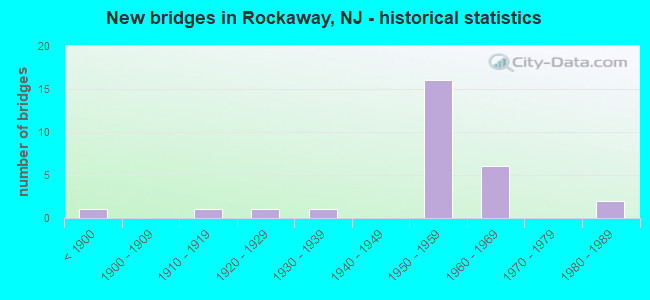
- New bridges - historical statistics
- 1Before 1900
- 11910-1919
- 11920-1929
- 11930-1939
- 161950-1959
- 61960-1969
- 21980-1989

- Reconstructed bridges - Historical Statistics
- 11960-1969
- 01970-1979
- 131980-1989
- 01990-1999
- 02000-2009
- 12010-2019


- Bridge Condition - Deck
- 55.0%Good
- 25.0%Satisfactory
- 20.0%Fair

- Bridge Condition - Superstructure
- 14.3%Good
- 28.6%Satisfactory
- 42.9%Fair
- 14.3%Poor

- Bridge Condition - Substructure
- 23.8%Good
- 57.1%Satisfactory
- 14.3%Fair
- 4.8%Poor

- Bridge Condition - Channel
- 40.0%Good
- 53.3%Satisfactory
- 6.7%Fair
Find on map >> Show street view
Structure Number: 1400814, Location: 0.6MI S OF US46&CR513 JCT (Lat: 40.878781, Lng: -74.525331), Route carried "on" structure: City street , Year Built: 1917, Year Reconstructed: 1960, Status: Open, Structure Length: 0.79m (2.59ft), Average Daily Traffic: 5,469 (year 2021), Truck Traffic: 1%, Average Future Daily Traffic: 6,673 (year 2041), Features Intersected: MILL BROOK, Facility Carried by Structure: PALMER ROAD
Minimum Vertical Clearance: 30+ m (98+ ft), Kilometerpoint: 0.000, Lanes on structure: 2, Owner: County Highway Agency, Approaching Roadway Width: 9.1m (29.9ft), Material/Design: Steel, Design/Construction: Stringer/Multi-beam, Number Of Spans In Main Unit: 1, Length of Maximum Span: 7.3m (24.0ft), Curb-To-Curb Width: 10.4m (34.1ft), Out-to-Out Width: 10.5m (34.4ft)
Condition: Deck: Fair, Superstructure: Poor, Substructure: Satisfactory, Channel: Satisfactory, Operating Rating: 81.6 metric tons, Method Used To Determine Operating Rating: Load Factor (LF), Inventory Rating: 49.0 metric tons, Method Used To Determine Inventory Rating: Load Factor (LF), Structural Evaluation: Meets minimum limits, Deck Geometry: Meets minimum limits, Waterway Adequacy: Equal to present minimum criteria, Approach Roadway Alignment: Somewhat better than minimum adequacy, Length Of Structure Improvement: 0.79m (2.59ft), Designated Inspection Frequency: Every 24 months, Inspection Date: August 2021, Bridge Improvement Cost: $381,000, Roadway Improvement Cost: $60,000, Total Project Cost: $662,000 ( Estimate for 2021), Deck Structure Type: Corrugated Steel, Wearing Surface/Protective System: Wearing Surface: Bituminous
Find on map >> Show street view
Structure Number: 1400909, Location: 0.6MI NW NJ53&CR603 JCT (Lat: 40.899250, Lng: -74.486969), Route carried "on" structure: City street , Year Built: 1988, Status: Open, Structure Length: 2.38m (7.81ft), Average Daily Traffic: 11,477 (year 2021), Truck Traffic: 4%, Average Future Daily Traffic: 14,004 (year 2041), Design Load: HS 20+Mod, Features Intersected: ROCKAWAY RIVER, Facility Carried by Structure: SAVAGE ROAD
Minimum Vertical Clearance: 30+ m (98+ ft), Kilometerpoint: 3.718, Lanes on structure: 2, Owner: County Highway Agency, Approaching Roadway Width: 12.2m (40.0ft), Skew: 1 degrees, Material/Design: Prestressed concrete, Design/Construction: Box Beam or Girders - Multiple, Number Of Spans In Main Unit: 1, Length of Maximum Span: 22.6m (74.1ft), Curb or Sidewalk Widths: Left: 1.8m (5.9ft), Right: 1.8m (5.9ft), Curb-To-Curb Width: 12.4m (40.7ft), Out-to-Out Width: 16.8m (55.1ft)
Condition: Deck: Satisfactory, Superstructure: Satisfactory, Substructure: Satisfactory, Channel: Satisfactory, Operating Rating: 81.6 metric tons, Method Used To Determine Operating Rating: Load Factor (LF), Inventory Rating: 40.8 metric tons, Method Used To Determine Inventory Rating: Load Factor (LF), Structural Evaluation: Equal to present minimum criteria, Deck Geometry: Somewhat better than minimum adequacy, Waterway Adequacy: Better than present minimum criteria, Approach Roadway Alignment: Better than present minimum criteria, Designated Inspection Frequency: Every 24 months, Underwater Inspection Frequency: Every 48 months, Inspection Date: August 2021, Underwater Inspection Date: July 2021, Deck Structure Type: Concrete Cast-file-Place, Wearing Surface/Protective System: Wearing Surface: Monolithic Concrete, Deck Protection: Epoxy Coated Reinforcing
Find on map >> Show street view
Structure Number: 1400914, Location: 0.4MI SE I-80&CR513 JCT (Lat: 40.906211, Lng: -74.497119), Route carried "on" structure: City street , Year Built: 1958, Status: Open, Structure Length: 1.83m (6.00ft), Average Daily Traffic: 7,040 (year 2021), Truck Traffic: 4%, Average Future Daily Traffic: 8,590 (year 2041), Design Load: HS 20, Features Intersected: BEAVER BROOK, Facility Carried by Structure: MORRIS AVE
Minimum Vertical Clearance: 30+ m (98+ ft), Kilometerpoint: 2.462, Lanes on structure: 2, Owner: County Highway Agency, Approaching Roadway Width: 11.0m (36.1ft), Material/Design: Prestressed concrete, Design/Construction: Stringer/Multi-beam, Number Of Spans In Main Unit: 1, Length of Maximum Span: 15.8m (51.8ft), Curb or Sidewalk Widths: Left: 1.8m (5.9ft), Right: 0.4m (1.3ft), Curb-To-Curb Width: 8.6m (28.2ft), Out-to-Out Width: 11.6m (38.1ft)
Condition: Deck: Fair, Superstructure: Satisfactory, Substructure: Satisfactory, Channel: Good, Operating Rating: 47.2 metric tons, Method Used To Determine Operating Rating: Load Factor (LF), Inventory Rating: 28.1 metric tons, Method Used To Determine Inventory Rating: Load Factor (LF), Structural Evaluation: Equal to present minimum criteria, Deck Geometry: High priority of replacement, Waterway Adequacy: Better than present minimum criteria, Approach Roadway Alignment: Equal to present desirable criteria, Length Of Structure Improvement: 1.83m (6.00ft), Designated Inspection Frequency: Every 24 months, Underwater Inspection Frequency: Every 48 months, Inspection Date: August 2021, Underwater Inspection Date: July 2019, Bridge Improvement Cost: $65,000, Roadway Improvement Cost: $24,000, Total Project Cost: $121,000 ( Estimate for 2021), Deck Structure Type: Concrete Cast-file-Place, Wearing Surface/Protective System: Wearing Surface: Monolithic Concrete
Find on map >> Show street view
Structure Number: 1400917, Location: 2.5MI NW of NJ10&NJ53 JCT (Lat: 40.868469, Lng: -74.517261), Route carried "on" structure: City street , Year Built: 1925, Year Reconstructed: 2010, Status: Open, Structure Length: 0.76m (2.49ft), Average Daily Traffic: 1,051 (year 2021), Truck Traffic: 1%, Average Future Daily Traffic: 1,282 (year 2041), Features Intersected: DEN BROOK, Facility Carried by Structure: MT. PLEASANT TPK.
Minimum Vertical Clearance: 30+ m (98+ ft), Kilometerpoint: 0.000, Lanes on structure: 1, Owner: County Highway Agency, Approaching Roadway Width: 6.1m (20.0ft), Skew: 1 degrees, Material/Design: Steel, Design/Construction: Stringer/Multi-beam, Number Of Spans In Main Unit: 1, Length of Maximum Span: 6.4m (21.0ft), Curb-To-Curb Width: 5.2m (17.1ft), Out-to-Out Width: 5.4m (17.7ft)
Condition: Deck: Good, Superstructure: Satisfactory, Substructure: Satisfactory, Channel: Satisfactory, Inventory Rating: 68.9 metric tons, Method Used To Determine Inventory Rating: Load Factor (LF), Structural Evaluation: Equal to present minimum criteria, Deck Geometry: High priority of replacement, Waterway Adequacy: Equal to present minimum criteria, Approach Roadway Alignment: Somewhat better than minimum adequacy, Length Of Structure Improvement: 0.76m (2.49ft), Designated Inspection Frequency: Every 24 months, Inspection Date: July 2021, Bridge Improvement Cost: $79,000, Roadway Improvement Cost: $12,000, Total Project Cost: $312,000 ( Estimate for 2021), Deck Structure Type: Corrugated Steel, Wearing Surface/Protective System: Wearing Surface: Bituminous
Find on map >> Show street view
Structure Number: 1400935, Location: 0.5MI SW OF I-80&NJ53 JCT (Lat: 40.887411, Lng: -74.487439), Route carried "on" structure: City street , Year Built: 1966, Status: Open, Structure Length: 3.29m (10.79ft), Average Daily Traffic: 92 (year 2021), Truck Traffic: 3%, Average Future Daily Traffic: 112 (year 2041), Features Intersected: INDIAN LAKE, Facility Carried by Structure: LENAPE ISLAND ROAD
Minimum Vertical Clearance: 30+ m (98+ ft), Kilometerpoint: 0.000, Lanes on structure: 1, Owner: County Highway Agency, Approaching Roadway Width: 5.5m (18.0ft), Material/Design: Steel, Design/Construction: Stringer/Multi-beam, Number Of Spans In Main Unit: 8, Length of Maximum Span: 5.5m (18.0ft), Curb or Sidewalk Widths: Left: 0.9m (3.0ft), Right: 0.0m, Curb-To-Curb Width: 4.0m (13.1ft), Out-to-Out Width: 5.6m (18.4ft)
Condition: Deck: Fair, Superstructure: Poor, Substructure: Fair, Channel: Satisfactory, Operating Rating: 32.7 metric tons, Method Used To Determine Operating Rating: Load Factor (LF), Inventory Rating: 19.1 metric tons, Method Used To Determine Inventory Rating: Load Factor (LF), Structural Evaluation: Meets minimum limits, Deck Geometry: Somewhat better than minimum adequacy, Waterway Adequacy: Better than present minimum criteria, Approach Roadway Alignment: Equal to present minimum criteria, Length Of Structure Improvement: 3.29m (10.79ft), Designated Inspection Frequency: Every 24 months, Critical Feature Inspection Frequency: Every 24 months, Inspection Date: August 2021, Critical Feature Inspection Date: August 2021, Bridge Improvement Cost: $839,000, Roadway Improvement Cost: $60,000, Total Project Cost: $1,240,000 ( Estimate for 2021), Deck Structure Type: Corrugated Steel, Wearing Surface/Protective System: Wearing Surface: Bituminous
Find on map >> Show street view
Structure Number: 1400976, Location: 0.16 MI E. OF CR 513 JCT (Lat: 40.899969, Lng: -74.511419), Route carried "on" structure: County highway 644, Year Built: 1840, Year Reconstructed: 1993, Status: Open, Structure Length: 2.83m (9.28ft), Average Daily Traffic: 14,777 (year 2021), Truck Traffic: 4%, Average Future Daily Traffic: 17,732 (year 2041), Design Load: H 20, Features Intersected: ROCKAWAY RIVER
Minimum Vertical Clearance: 30+ m (98+ ft), Kilometerpoint: 1.287, Lanes on structure: 2, Owner: County Highway Agency, Approaching Roadway Width: 10.1m (33.1ft), Material/Design: Masonry, Design/Construction: Arch - Deck, Number Of Spans In Main Unit: 3, Length of Maximum Span: 8.2m (26.9ft), Curb or Sidewalk Widths: Left: 2.1m (6.9ft), Right: 2.5m (8.2ft), Curb-To-Curb Width: 10.1m (33.1ft), Out-to-Out Width: 15.5m (50.9ft)
Condition: Superstructure: Poor, Substructure: Poor, Channel: Satisfactory, Operating Rating: 40.8 metric tons, Method Used To Determine Operating Rating: Load Factor (LF), Inventory Rating: 24.5 metric tons, Method Used To Determine Inventory Rating: Load Factor (LF), Structural Evaluation: Meets minimum limits, Deck Geometry: Meets minimum limits, Waterway Adequacy: Superior to present desirable criteria, Approach Roadway Alignment: Equal to present desirable criteria, Length Of Structure Improvement: 2.83m (9.28ft), Designated Inspection Frequency: Every 24 months, Inspection Date: August 2021, Bridge Improvement Cost: $1,879,000, Roadway Improvement Cost: $56,000, Total Project Cost: $2,989,000 ( Estimate for 2021)
Find on map >> Show street view
Structure Number: 1401158, Location: 2.5 MI WEST OF RT 53 JCT (Lat: 40.869589, Lng: -74.515489), Route carried "on" structure: State highway 10, Year Built: 1932, Status: Open, Structure Length: 0.73m (2.40ft), Average Daily Traffic: 54,070 (year 2020), Truck Traffic: 4%, Average Future Daily Traffic: 64,884 (year 2040), Features Intersected: DEN BROOK
Minimum Vertical Clearance: 30+ m (98+ ft), Kilometerpoint: 13.132, Lanes on structure: 6, Base Highway Network: Yes, Owner: State Highway Agency, Approaching Roadway Width: 25.2m (82.7ft), Skew: 30 degrees, Material/Design: Concrete, Design/Construction: Culvert, Number Of Spans In Main Unit: 1, Length of Maximum Span: 6.4m (21.0ft), Curb or Sidewalk Widths: Left: 1.2m (3.9ft), Right: 1.2m (3.9ft)
Condition: Channel: Satisfactory, Culverts: Fair, Operating Rating: 78.9 metric tons, Method Used To Determine Operating Rating: Load Factor (LF), Inventory Rating: 47.2 metric tons, Method Used To Determine Inventory Rating: Load Factor (LF), Structural Evaluation: Somewhat better than minimum adequacy, Waterway Adequacy: Superior to present desirable criteria, Approach Roadway Alignment: Equal to present desirable criteria, Designated Inspection Frequency: Every 24 months, Inspection Date: April 2020
Find on map >> Show street view
Structure Number: 1401288, Location: 0.34MI W OF I-80&NJ53 JCT (Lat: 40.890081, Lng: -74.484219), Route carried "on" structure: City street , Year Built: 1959, Status: Open, Structure Length: 1.31m (4.30ft), Average Daily Traffic: 13,480 (year 2021), Truck Traffic: 1%, Average Future Daily Traffic: 16,448 (year 2041), Features Intersected: INDIAN LAKE, Facility Carried by Structure: NORTH SHORE RD
Minimum Vertical Clearance: 30+ m (98+ ft), Kilometerpoint: 0.000, Lanes on structure: 2, Owner: County Highway Agency, Approaching Roadway Width: 7.0m (23.0ft), Material/Design: Prestressed concrete, Design/Construction: Slab, Number Of Spans In Main Unit: 1, Length of Maximum Span: 12.8m (42.0ft), Curb or Sidewalk Widths: Left: 1.5m (4.9ft), Right: 0.0m, Curb-To-Curb Width: 6.9m (22.6ft), Out-to-Out Width: 7.3m (24.0ft)
Condition: Deck: Fair, Superstructure: Fair, Substructure: Fair, Channel: Good, Operating Rating: 47.2 metric tons, Method Used To Determine Operating Rating: Load Factor (LF), Inventory Rating: 28.1 metric tons, Method Used To Determine Inventory Rating: Load Factor (LF), Structural Evaluation: Somewhat better than minimum adequacy, Deck Geometry: High priority of replacement, Waterway Adequacy: Superior to present desirable criteria, Approach Roadway Alignment: Equal to present minimum criteria, Length Of Structure Improvement: 1.31m (4.30ft), Designated Inspection Frequency: Every 24 months, Underwater Inspection Frequency: Every 24 months, Inspection Date: August 2021, Underwater Inspection Date: July 2021, Bridge Improvement Cost: $291,000, Roadway Improvement Cost: $23,000, Total Project Cost: $495,000 ( Estimate for 2021), Deck Structure Type: Concrete Precast Panels, Wearing Surface/Protective System: Wearing Surface: Bituminous
Find on map >> Show street view
Structure Number: 1409157, Location: 2.6 MI EAST OF RT 15 (Lat: 40.891831, Lng: -74.517931), Route carried "on" structure: US 46, Year Built: 1989, Status: Open, Structure Length: 18.32m (60.10ft), Average Daily Traffic: 21,120 (year 2019), Truck Traffic: 4%, Average Future Daily Traffic: 25,344 (year 2039), Design Load: HS 20+Mod, Features Intersected: ROCKAWAY RIVER, ABAND RR
Minimum Vertical Clearance: 30+ m (98+ ft), Kilometerpoint: 65.468, Lanes on structure: 2, Base Highway Network: Yes, Owner: State Highway Agency, Approaching Roadway Width: 15.5m (50.9ft), Material/Design: Steel, Design/Construction: Stringer/Multi-beam, Number Of Spans In Main Unit: 1, Number Of Approach Spans: 6, Length of Maximum Span: 39.6m (129.9ft), Curb or Sidewalk Widths: Left: 1.8m (5.9ft), Right: 0.0m, Curb-To-Curb Width: 15.5m (50.9ft), Out-to-Out Width: 18.2m (59.7ft)
Condition: Deck: Good, Superstructure: Fair, Substructure: Satisfactory, Channel: Good, Operating Rating: 65.3 metric tons, Method Used To Determine Operating Rating: Load Factor (LF), Inventory Rating: 36.3 metric tons, Method Used To Determine Inventory Rating: Load Factor (LF), Structural Evaluation: Somewhat better than minimum adequacy, Deck Geometry: Superior to present desirable criteria, Underclear: Better than present minimum criteria, Waterway Adequacy: Superior to present desirable criteria, Approach Roadway Alignment: Equal to present desirable criteria, Designated Inspection Frequency: Every 24 months, Inspection Date: March 2021, Deck Structure Type: Concrete Cast-file-Place, Wearing Surface/Protective System: Wearing Surface: Monolithic Concrete, Deck Protection: Epoxy Coated Reinforcing
Find on map >> Show street view
Structure Number: 141316, Location: 1.3 MI EAST OF NJ15 (Lat: 40.910450, Lng: -74.547511), Route carried "on" structure: County highway 661, Year Built: 1958, Year Reconstructed: 1986, Status: Open, Structure Length: 4.97m (16.31ft), Average Daily Traffic: 14,176 (year 2021), Truck Traffic: 4%, Average Future Daily Traffic: 17,297 (year 2041), Design Load: HS 25 or greater, Features Intersected: I-80, Facility Carried by Structure: MT HOPE-DOVER
Minimum Vertical Clearance: 30+ m (98+ ft), Kilometerpoint: 2.865, Lanes on structure: 5, Lanes under structure: 9, Owner: State Highway Agency, Approaching Roadway Width: 20.4m (66.9ft), Skew: 21 degrees, Material/Design: Prestressed concrete, Design/Construction: Stringer/Multi-beam, Number Of Spans In Main Unit: 2, Length of Maximum Span: 24.1m (79.1ft), Curb or Sidewalk Widths: Left: 1.8m (5.9ft), Right: 1.8m (5.9ft), Curb-To-Curb Width: 20.6m (67.6ft), Out-to-Out Width: 27.3m (89.6ft)
Condition: Deck: Good, Superstructure: Good, Substructure: Satisfactory, Operating Rating: 64.4 metric tons, Method Used To Determine Operating Rating: Load Factor (LF), Inventory Rating: 39.0 metric tons, Method Used To Determine Inventory Rating: Load Factor (LF), Structural Evaluation: Equal to present minimum criteria, Deck Geometry: Somewhat better than minimum adequacy, Underclear: Somewhat better than minimum adequacy, Approach Roadway Alignment: Equal to present desirable criteria, Designated Inspection Frequency: Every 24 months, Inspection Date: March 2021, Deck Structure Type: Concrete Cast-file-Place, Wearing Surface/Protective System: Wearing Surface: Monolithic Concrete, Deck Protection: Epoxy Coated Reinforcing
Find on map >> Show street view
Structure Number: 1413164, Location: 3.3 MI EAST OF RTE 15 (Lat: 40.910850, Lng: -74.509781), Route carried "on" structure: Interstate 80, Year Built: 1958, Year Reconstructed: 1991, Status: Open, Structure Length: 2.04m (6.69ft), Average Daily Traffic: 59,350 (year 2020), Truck Traffic: 9%, Average Future Daily Traffic: 72,407 (year 2040), Design Load: HS 20+Mod, Features Intersected: WHITE MEADOW AVENUE
Minimum Vertical Clearance: 30.45m (99.90ft), Kilometerpoint: 60.012, Lanes on structure: 4, Lanes under structure: 2, Base Highway Network: Yes, Owner: State Highway Agency, Approaching Roadway Width: 21.0m (68.9ft), Skew: 2 degrees, Material/Design: Prestressed concrete, Design/Construction: Stringer/Multi-beam, Number Of Spans In Main Unit: 1, Length of Maximum Span: 18.3m (60.0ft), Curb-To-Curb Width: 21.4m (70.2ft), Out-to-Out Width: 22.5m (73.8ft)
Condition: Deck: Good, Superstructure: Satisfactory, Substructure: Satisfactory, Operating Rating: 56.2 metric tons, Method Used To Determine Operating Rating: Load Factor (LF), Inventory Rating: 33.6 metric tons, Method Used To Determine Inventory Rating: Load Factor (LF), Structural Evaluation: Equal to present minimum criteria, Deck Geometry: Better than present minimum criteria, Underclear: Equal to present desirable criteria, Approach Roadway Alignment: Equal to present desirable criteria, Designated Inspection Frequency: Every 24 months, Inspection Date: April 2020, Deck Structure Type: Concrete Cast-file-Place, Wearing Surface/Protective System: Wearing Surface: Bituminous, Membrane: Other, Deck Protection: Epoxy Coated Reinforcing
Find on map >> Show street view
Structure Number: 1413165, Location: 3.3 MILES EAST OF RT.15 (Lat: 40.911181, Lng: -74.511111), Route carried "on" structure: Interstate 80, Year Built: 1958, Year Reconstructed: 1991, Status: Open, Structure Length: 2.01m (6.59ft), Average Daily Traffic: 63,300 (year 2020), Truck Traffic: 9%, Average Future Daily Traffic: 77,226 (year 2040), Design Load: HS 20+Mod, Features Intersected: WHITE MEADOW AVENUE
Minimum Vertical Clearance: 30.45m (99.90ft), Kilometerpoint: 60.012, Lanes on structure: 4, Lanes under structure: 2, Base Highway Network: Yes, Owner: State Highway Agency, Approaching Roadway Width: 21.3m (69.9ft), Skew: 2 degrees, Material/Design: Prestressed concrete, Design/Construction: Stringer/Multi-beam, Number Of Spans In Main Unit: 1, Length of Maximum Span: 18.3m (60.0ft), Curb-To-Curb Width: 21.2m (69.6ft), Out-to-Out Width: 22.5m (73.8ft)
Condition: Deck: Good, Superstructure: Fair, Substructure: Satisfactory, Operating Rating: 56.2 metric tons, Method Used To Determine Operating Rating: Load Factor (LF), Inventory Rating: 33.6 metric tons, Method Used To Determine Inventory Rating: Load Factor (LF), Structural Evaluation: Somewhat better than minimum adequacy, Deck Geometry: Better than present minimum criteria, Underclear: Equal to present minimum criteria, Approach Roadway Alignment: Equal to present desirable criteria, Designated Inspection Frequency: Every 24 months, Inspection Date: April 2020, Deck Structure Type: Concrete Cast-file-Place, Wearing Surface/Protective System: Wearing Surface: Bituminous, Membrane: Other, Deck Protection: Epoxy Coated Reinforcing
Find on map >> Show street view
Structure Number: 141317, Location: 0.5 MI E OF I-80 EXIT 37 (Lat: 40.905469, Lng: -74.497731), Route carried "on" structure: Business City street , Year Built: 1958, Status: Open, Structure Length: 1.77m (5.81ft), Average Daily Traffic: 406 (year 2020), Truck Traffic: 1%, Average Future Daily Traffic: 495 (year 2040), Design Load: HS 20, Features Intersected: BEAVER BROOK, Facility Carried by Structure: VANDERHOOF AVE
Minimum Vertical Clearance: 30+ m (98+ ft), Kilometerpoint: 61.203, Lanes on structure: 2, Owner: State Highway Agency, Approaching Roadway Width: 7.3m (24.0ft), Material/Design: Prestressed concrete, Design/Construction: Stringer/Multi-beam, Number Of Spans In Main Unit: 1, Length of Maximum Span: 16.2m (53.1ft), Curb or Sidewalk Widths: Left: 0.4m (1.3ft), Right: 1.8m (5.9ft), Curb-To-Curb Width: 7.3m (24.0ft), Out-to-Out Width: 10.4m (34.1ft)
Condition: Deck: Satisfactory, Superstructure: Good, Substructure: Good, Channel: Fair, Operating Rating: 58.1 metric tons, Method Used To Determine Operating Rating: Load Factor (LF), Inventory Rating: 34.5 metric tons, Method Used To Determine Inventory Rating: Load Factor (LF), Structural Evaluation: Better than present minimum criteria, Deck Geometry: Meets minimum limits, Waterway Adequacy: Superior to present desirable criteria, Approach Roadway Alignment: Equal to present desirable criteria, Designated Inspection Frequency: Every 24 months, Underwater Inspection Frequency: Every 48 months, Inspection Date: March 2020, Underwater Inspection Date: June 2020, Deck Structure Type: Concrete Cast-file-Place, Wearing Surface/Protective System: Wearing Surface: Monolithic Concrete
Find on map >> Show street view
Structure Number: 1413171, Location: 0.5 MI E OF I-80 EXIT 37 (Lat: 40.905750, Lng: -74.497581), Route carried "on" structure: Interstate 80, Year Built: 1958, Year Reconstructed: 1991, Status: Open, Structure Length: 1.74m (5.71ft), Average Daily Traffic: 81,681 (year 2020), Truck Traffic: 9%, Average Future Daily Traffic: 99,666 (year 2040), Design Load: HS 20+Mod, Features Intersected: BEAVER BROOK
Minimum Vertical Clearance: 30+ m (98+ ft), Kilometerpoint: 61.203, Lanes on structure: 4, Base Highway Network: Yes, Owner: State Highway Agency, Approaching Roadway Width: 20.7m (67.9ft), Material/Design: Prestressed concrete, Design/Construction: Stringer/Multi-beam, Number Of Spans In Main Unit: 1, Length of Maximum Span: 16.2m (53.1ft), Curb-To-Curb Width: 20.9m (68.6ft), Out-to-Out Width: 22.1m (72.5ft)
Condition: Deck: Satisfactory, Superstructure: Good, Substructure: Satisfactory, Channel: Good, Operating Rating: 51.7 metric tons, Method Used To Determine Operating Rating: Load Factor (LF), Inventory Rating: 30.8 metric tons, Method Used To Determine Inventory Rating: Load Factor (LF), Structural Evaluation: Equal to present minimum criteria, Deck Geometry: Better than present minimum criteria, Waterway Adequacy: Superior to present desirable criteria, Approach Roadway Alignment: Equal to present desirable criteria, Designated Inspection Frequency: Every 24 months, Underwater Inspection Frequency: Every 48 months, Inspection Date: April 2020, Underwater Inspection Date: June 2018, Deck Structure Type: Concrete Cast-file-Place, Wearing Surface/Protective System: Wearing Surface: Bituminous, Membrane: Other
Find on map >> Show street view
Structure Number: 1413172, Location: .5 MI.E.OF I-80 EXIT-37 (Lat: 40.905900, Lng: -74.497439), Route carried "on" structure: Interstate 80, Year Built: 1958, Year Reconstructed: 1991, Status: Open, Structure Length: 1.74m (5.71ft), Average Daily Traffic: 81,681 (year 2020), Truck Traffic: 9%, Average Future Daily Traffic: 99,666 (year 2040), Design Load: HS 20+Mod, Features Intersected: BEAVER BROOK
Minimum Vertical Clearance: 30+ m (98+ ft), Kilometerpoint: 61.203, Lanes on structure: 4, Base Highway Network: Yes, Owner: State Highway Agency, Approaching Roadway Width: 20.7m (67.9ft), Material/Design: Prestressed concrete, Design/Construction: Stringer/Multi-beam, Number Of Spans In Main Unit: 1, Length of Maximum Span: 15.8m (51.8ft), Curb-To-Curb Width: 20.9m (68.6ft), Out-to-Out Width: 22.1m (72.5ft)
Condition: Deck: Satisfactory, Superstructure: Fair, Substructure: Satisfactory, Channel: Good, Operating Rating: 54.4 metric tons, Method Used To Determine Operating Rating: Load Factor (LF), Inventory Rating: 32.7 metric tons, Method Used To Determine Inventory Rating: Load Factor (LF), Structural Evaluation: Somewhat better than minimum adequacy, Deck Geometry: Better than present minimum criteria, Waterway Adequacy: Superior to present desirable criteria, Approach Roadway Alignment: Equal to present desirable criteria, Designated Inspection Frequency: Every 24 months, Underwater Inspection Frequency: Every 48 months, Inspection Date: April 2020, Underwater Inspection Date: June 2018, Deck Structure Type: Concrete Cast-file-Place, Wearing Surface/Protective System: Wearing Surface: Bituminous, Membrane: Other
Find on map >> Show street view
Structure Number: 1413174, Location: 0.17 MI WEST OF US 46 (Lat: 40.899481, Lng: -74.489900), Route carried "on" structure: Interstate 80, Year Built: 1958, Year Reconstructed: 1993, Status: Open, Structure Length: 5.12m (16.80ft), Average Daily Traffic: 73,361 (year 2019), Truck Traffic: 9%, Average Future Daily Traffic: 89,513 (year 2039), Design Load: HS 20+Mod, Features Intersected: ROCKAWAY RIVER
Minimum Vertical Clearance: 30+ m (98+ ft), Kilometerpoint: 62.185, Lanes on structure: 4, Base Highway Network: Yes, Owner: State Highway Agency, Approaching Roadway Width: 21.0m (68.9ft), Skew: 3 degrees, Material/Design: Prestressed concrete, Design/Construction: Stringer/Multi-beam, Number Of Spans In Main Unit: 2, Length of Maximum Span: 24.4m (80.1ft), Curb-To-Curb Width: 20.9m (68.6ft), Out-to-Out Width: 22.1m (72.5ft)
Condition: Deck: Good, Superstructure: Fair, Substructure: Good, Channel: Satisfactory, Operating Rating: 53.5 metric tons, Method Used To Determine Operating Rating: Load Factor (LF), Inventory Rating: 32.7 metric tons, Method Used To Determine Inventory Rating: Load Factor (LF), Structural Evaluation: Somewhat better than minimum adequacy, Deck Geometry: Better than present minimum criteria, Waterway Adequacy: Superior to present desirable criteria, Approach Roadway Alignment: Equal to present desirable criteria, Designated Inspection Frequency: Every 24 months, Inspection Date: April 2021, Deck Structure Type: Concrete Cast-file-Place, Wearing Surface/Protective System: Wearing Surface: Bituminous, Deck Protection: Epoxy Coated Reinforcing
Find on map >> Show street view
Structure Number: 1413175, Location: 0.17 MILE WEST OF US 46 (Lat: 40.899511, Lng: -74.489600), Route carried "on" structure: Interstate 80, Year Built: 1958, Year Reconstructed: 1993, Status: Open, Structure Length: 5.09m (16.70ft), Average Daily Traffic: 74,880 (year 2021), Truck Traffic: 9%, Average Future Daily Traffic: 91,304 (year 2041), Design Load: HS 20+Mod, Features Intersected: ROCKAWAY RIVER
Minimum Vertical Clearance: 30+ m (98+ ft), Kilometerpoint: 62.185, Lanes on structure: 5, Base Highway Network: Yes, Owner: State Highway Agency, Approaching Roadway Width: 21.3m (69.9ft), Skew: 3 degrees, Material/Design: Prestressed concrete, Design/Construction: Stringer/Multi-beam, Number Of Spans In Main Unit: 2, Length of Maximum Span: 24.4m (80.1ft), Curb-To-Curb Width: 21.2m (69.6ft), Out-to-Out Width: 22.4m (73.5ft)
Condition: Deck: Good, Superstructure: Fair, Substructure: Satisfactory, Channel: Satisfactory, Operating Rating: 48.1 metric tons, Method Used To Determine Operating Rating: Load Factor (LF), Inventory Rating: 28.1 metric tons, Method Used To Determine Inventory Rating: Load Factor (LF), Structural Evaluation: Somewhat better than minimum adequacy, Deck Geometry: Meets minimum limits, Waterway Adequacy: Superior to present desirable criteria, Approach Roadway Alignment: Equal to present desirable criteria, Designated Inspection Frequency: Every 24 months, Inspection Date: March 2021, Deck Structure Type: Concrete Cast-file-Place, Wearing Surface/Protective System: Wearing Surface: Bituminous, Deck Protection: Epoxy Coated Reinforcing
Find on map >> Show street view
Structure Number: 1413176, Location: 0.8 MI WEST OF RTE 53 (Lat: 40.897189, Lng: -74.488239), Route carried "on" structure: Interstate 80, Year Built: 1958, Year Reconstructed: 1993, Status: Open, Structure Length: 4.57m (14.99ft), Average Daily Traffic: 68,600 (year 2020), Truck Traffic: 9%, Average Future Daily Traffic: 82,300 (year 2040), Design Load: HS 20+Mod, Features Intersected: US 46 & I-80 RAMP L
Minimum Vertical Clearance: 30+ m (98+ ft), Kilometerpoint: 62.475, Lanes on structure: 5, Lanes under structure: 5, Base Highway Network: Yes, Owner: State Highway Agency, Approaching Roadway Width: 21.0m (68.9ft), Skew: 4 degrees, Material/Design: Prestressed concrete, Design/Construction: Stringer/Multi-beam, Number Of Spans In Main Unit: 2, Length of Maximum Span: 30.2m (99.1ft), Curb-To-Curb Width: 21.2m (69.6ft), Out-to-Out Width: 22.4m (73.5ft)
Condition: Deck: Good, Superstructure: Fair, Substructure: Fair, Operating Rating: 37.2 metric tons, Method Used To Determine Operating Rating: Load Factor (LF), Inventory Rating: 21.8 metric tons, Method Used To Determine Inventory Rating: Load Factor (LF), Structural Evaluation: Somewhat better than minimum adequacy, Deck Geometry: Meets minimum limits, Underclear: Meets minimum limits, Approach Roadway Alignment: Equal to present desirable criteria, Designated Inspection Frequency: Every 24 months, Inspection Date: June 2020, Deck Structure Type: Concrete Cast-file-Place, Wearing Surface/Protective System: Wearing Surface: Bituminous, Deck Protection: Epoxy Coated Reinforcing
Find on map >> Show street view
Structure Number: 1413177, Location: 0.8 MILES WEST OF NJ 53 (Lat: 40.896789, Lng: -74.487989), Route carried "on" structure: Interstate 80, Year Built: 1958, Year Reconstructed: 1993, Status: Open, Structure Length: 4.36m (14.30ft), Average Daily Traffic: 68,600 (year 2020), Truck Traffic: 9%, Average Future Daily Traffic: 82,300 (year 2040), Design Load: HS 20+Mod, Features Intersected: US 46 & I-80 RAMP L
Minimum Vertical Clearance: 30+ m (98+ ft), Kilometerpoint: 62.475, Lanes on structure: 4, Lanes under structure: 5, Base Highway Network: Yes, Owner: State Highway Agency, Approaching Roadway Width: 21.0m (68.9ft), Skew: 4 degrees, Material/Design: Prestressed concrete, Design/Construction: Stringer/Multi-beam, Number Of Spans In Main Unit: 2, Length of Maximum Span: 23.8m (78.1ft), Curb-To-Curb Width: 21.2m (69.6ft), Out-to-Out Width: 22.4m (73.5ft)
Condition: Deck: Good, Superstructure: Fair, Substructure: Satisfactory, Operating Rating: 41.7 metric tons, Method Used To Determine Operating Rating: Load Factor (LF), Inventory Rating: 24.5 metric tons, Method Used To Determine Inventory Rating: Load Factor (LF), Structural Evaluation: Somewhat better than minimum adequacy, Deck Geometry: Better than present minimum criteria, Underclear: Meets minimum limits, Approach Roadway Alignment: Equal to present desirable criteria, Designated Inspection Frequency: Every 24 months, Inspection Date: June 2020, Deck Structure Type: Concrete Cast-file-Place, Wearing Surface/Protective System: Wearing Surface: Bituminous, Deck Protection: Epoxy Coated Reinforcing
Find on map >> Show street view
Structure Number: 141415, Location: 0.2 MI E OF US 46 INT (Lat: 40.894781, Lng: -74.486789), Route carried "on" structure: Interstate 80, Year Built: 1961, Year Reconstructed: 1993, Status: Open, Structure Length: 2.01m (6.59ft), Average Daily Traffic: 68,600 (year 2020), Truck Traffic: 9%, Average Future Daily Traffic: 82,300 (year 2040), Design Load: HS 20+Mod, Features Intersected: FRANKLIN ROAD
Minimum Vertical Clearance: 30+ m (98+ ft), Kilometerpoint: 62.748, Lanes on structure: 4, Lanes under structure: 2, Base Highway Network: Yes, Owner: State Highway Agency, Approaching Roadway Width: 21.0m (68.9ft), Skew: 2 degrees, Material/Design: Prestressed concrete, Design/Construction: Stringer/Multi-beam, Number Of Spans In Main Unit: 1, Length of Maximum Span: 18.3m (60.0ft), Curb-To-Curb Width: 20.9m (68.6ft), Out-to-Out Width: 22.1m (72.5ft)
Condition: Deck: Good, Superstructure: Satisfactory, Substructure: Good, Operating Rating: 69.9 metric tons, Method Used To Determine Operating Rating: Load Factor (LF), Inventory Rating: 41.7 metric tons, Method Used To Determine Inventory Rating: Load Factor (LF), Structural Evaluation: Equal to present minimum criteria, Deck Geometry: Better than present minimum criteria, Underclear: Equal to present minimum criteria, Approach Roadway Alignment: Equal to present desirable criteria, Designated Inspection Frequency: Every 24 months, Inspection Date: July 2020, Deck Structure Type: Concrete Cast-file-Place, Wearing Surface/Protective System: Wearing Surface: Bituminous, Deck Protection: Epoxy Coated Reinforcing
Find on map >> Show street view
Structure Number: 1414151, Location: 0.18 MI EAST OF RTE 46 (Lat: 40.895031, Lng: -74.486569), Route carried "on" structure: Interstate 80, Year Built: 1961, Year Reconstructed: 1993, Status: Open, Structure Length: 2.01m (6.59ft), Average Daily Traffic: 74,102 (year 2020), Truck Traffic: 9%, Average Future Daily Traffic: 90,419 (year 2040), Design Load: HS 20, Features Intersected: FRANKLIN RD
Minimum Vertical Clearance: 30+ m (98+ ft), Kilometerpoint: 62.748, Lanes on structure: 4, Lanes under structure: 2, Base Highway Network: Yes, Owner: State Highway Agency, Approaching Roadway Width: 21.0m (68.9ft), Skew: 2 degrees, Material/Design: Prestressed concrete, Design/Construction: Stringer/Multi-beam, Number Of Spans In Main Unit: 1, Length of Maximum Span: 18.3m (60.0ft), Curb-To-Curb Width: 20.9m (68.6ft), Out-to-Out Width: 22.1m (72.5ft)
Condition: Deck: Satisfactory, Superstructure: Satisfactory, Substructure: Good, Operating Rating: 49.9 metric tons, Method Used To Determine Operating Rating: Load Factor (LF), Inventory Rating: 29.9 metric tons, Method Used To Determine Inventory Rating: Load Factor (LF), Structural Evaluation: Equal to present minimum criteria, Deck Geometry: Better than present minimum criteria, Underclear: Equal to present minimum criteria, Approach Roadway Alignment: Equal to present desirable criteria, Designated Inspection Frequency: Every 24 months, Inspection Date: April 2020, Deck Structure Type: Concrete Cast-file-Place, Wearing Surface/Protective System: Wearing Surface: Bituminous, Membrane: Other
Find on map >> Show street view
Structure Number: 1414152, Location: 0.57 MI EAST OF US 46 (Lat: 40.890881, Lng: -74.481439), Route carried "on" structure: Interstate 80, Year Built: 1961, Year Reconstructed: 1993, Status: Open, Structure Length: 1.68m (5.51ft), Average Daily Traffic: 81,412 (year 2021), Truck Traffic: 9%, Average Future Daily Traffic: 99,339 (year 2041), Design Load: HS 20+Mod, Features Intersected: DEN BROOK
Minimum Vertical Clearance: 30+ m (98+ ft), Kilometerpoint: 63.376, Lanes on structure: 4, Base Highway Network: Yes, Owner: State Highway Agency, Approaching Roadway Width: 21.0m (68.9ft), Skew: 3 degrees, Material/Design: Prestressed concrete, Design/Construction: Stringer/Multi-beam, Number Of Spans In Main Unit: 1, Length of Maximum Span: 14.9m (48.9ft), Curb-To-Curb Width: 20.9m (68.6ft), Out-to-Out Width: 22.1m (72.5ft)
Condition: Deck: Good, Superstructure: Fair, Substructure: Good, Channel: Good, Operating Rating: 49.0 metric tons, Method Used To Determine Operating Rating: Load Factor (LF), Inventory Rating: 29.0 metric tons, Method Used To Determine Inventory Rating: Load Factor (LF), Structural Evaluation: Somewhat better than minimum adequacy, Deck Geometry: Better than present minimum criteria, Waterway Adequacy: Superior to present desirable criteria, Approach Roadway Alignment: Equal to present desirable criteria, Designated Inspection Frequency: Every 24 months, Inspection Date: April 2021, Deck Structure Type: Concrete Cast-file-Place, Wearing Surface/Protective System: Wearing Surface: Bituminous, Deck Protection: Epoxy Coated Reinforcing
Find on map >> Show street view
Structure Number: 1413164, Location: 3.3 MI EAST OF RTE 15 (Lat: 40.910850, Lng: -74.509781), Route carried "under" structure: City street , Year Built: 1958, Structure Length: 0. m, Average Daily Traffic: 2,125 (year 2020), Truck Traffic: 3%, Features Intersected: WHITE MEADOW AVENUE, Facility Carried by Structure: I-80 EB
Minimum Vertical Clearance: 5.77m (18.93ft), Kilometerpoint: 7.998, Lanes on structure: 4, Lanes under structure: 2, Material/Design: Prestressed concrete, Design/Construction: Stringer/Multi-beam, Length of Maximum Span: 18.3m (60.0ft)
Find on map >> Show street view
Structure Number: 1413165, Location: 3.3 MILES EAST OF RT.15 (Lat: 40.911181, Lng: -74.511111), Route carried "under" structure: City street , Year Built: 1958, Structure Length: 0. m, Average Daily Traffic: 2,125 (year 2020), Truck Traffic: 3%, Features Intersected: WHITE MEADOW AVENUE, Facility Carried by Structure: I-80 WESTBOUND
Minimum Vertical Clearance: 4.50m (14.76ft), Kilometerpoint: 7.998, Lanes on structure: 4, Lanes under structure: 2, Material/Design: Prestressed concrete, Design/Construction: Stringer/Multi-beam, Length of Maximum Span: 18.3m (60.0ft)
Find on map >> Show street view
Structure Number: 1413176, Location: 0.8 MI WEST OF RTE 53 (Lat: 40.897189, Lng: -74.488239), Route carried "under" structure: US 46, Year Built: 1958, Structure Length: 0. m, Average Daily Traffic: 26,000 (year 2020), Truck Traffic: 4%, Features Intersected: US 46 & I-80 RAMP L, Facility Carried by Structure: I-80 EB
Minimum Vertical Clearance: 4.90m (16.08ft), Kilometerpoint: 68.140, Lanes on structure: 5, Lanes under structure: 5, Material/Design: Prestressed concrete, Design/Construction: Stringer/Multi-beam, Length of Maximum Span: 30.2m (99.1ft)
Find on map >> Show street view
Structure Number: 1413177, Location: 0.8 MILES WEST OF NJ 53 (Lat: 40.896789, Lng: -74.487989), Route carried "under" structure: US 46, Year Built: 1958, Structure Length: 0. m, Average Daily Traffic: 26,000 (year 2020), Truck Traffic: 4%, Features Intersected: US 46 & I-80 RAMP L, Facility Carried by Structure: I-80 WB
Minimum Vertical Clearance: 5.72m (18.77ft), Kilometerpoint: 68.172, Lanes on structure: 4, Lanes under structure: 5, Material/Design: Prestressed concrete, Design/Construction: Stringer/Multi-beam, Length of Maximum Span: 23.8m (78.1ft)
Find on map >> Show street view
Structure Number: 141415, Location: 0.2 MI E OF US 46 INT (Lat: 40.894781, Lng: -74.486789), Route carried "under" structure: City street , Year Built: 1961, Structure Length: 0. m, Average Daily Traffic: 2,960 (year 2020), Truck Traffic: 4%, Features Intersected: FRANKLIN ROAD, Facility Carried by Structure: I-80 EB
Minimum Vertical Clearance: 4.80m (15.75ft), Kilometerpoint: 3.106, Lanes on structure: 4, Lanes under structure: 2, Material/Design: Prestressed concrete, Design/Construction: Stringer/Multi-beam, Length of Maximum Span: 18.3m (60.0ft)
Find on map >> Show street view
Structure Number: 1414151, Location: 0.18 MI EAST OF RTE 46 (Lat: 40.895031, Lng: -74.486569), Route carried "under" structure: Other road , Year Built: 1961, Structure Length: 0. m, Average Daily Traffic: 3,216 (year 2020), Truck Traffic: 4%, Features Intersected: FRANKLIN RD, Facility Carried by Structure: RTE I-80 WB
Minimum Vertical Clearance: 4.70m (15.42ft), Kilometerpoint: 3.122, Lanes on structure: 4, Lanes under structure: 2, Material/Design: Prestressed concrete, Design/Construction: Stringer/Multi-beam, Length of Maximum Span: 18.3m (60.0ft)