Bridge Statistics for Ripon, California (CA)
Condition, Traffic, Stress, Structural Evaluation, Project Costs
- National Bridge Inventory (NBI) Statistics
- 20Number of bridges
- 203ft / 62.4mTotal length
- 732,186Total average daily traffic
- 99,651Total average daily truck traffic
- National Bridge Inventory (NBI) Registered Bridges for Ripon
- No street view available for this location
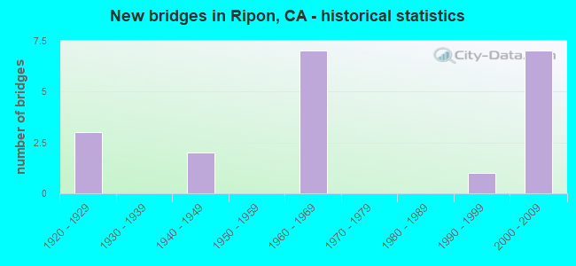
- New bridges - historical statistics
- 31920-1929
- 21940-1949
- 71960-1969
- 11990-1999
- 72000-2009


- Bridge Condition - Deck
- 90.9%Good
- 9.1%Fair

- Bridge Condition - Superstructure
- 81.8%Good
- 18.2%Fair

- Bridge Condition - Substructure
- 63.6%Good
- 9.1%Satisfactory
- 27.3%Fair

- Bridge Condition - Channel
- 33.3%Excellent
- 16.7%Very good
- 33.3%Good
- 16.7%Poor
Find on map >> Show street view
Structure Number: 29 006, Location: 10-SJ-088-6.10 (Lat: 38.051903, Lng: -121.188000), Route carried "on" structure: State highway 88, Year Built: 1947, Status: Open, Structure Length: 2.26m (7.41ft), Average Daily Traffic: 6,700 (year 2009), Average Future Daily Traffic: 23,417 (year 2039), Design Load: HS 20, Features Intersected: CALAVERAS RIVER
Minimum Vertical Clearance: 30+ m (98+ ft), Kilometerpoint: 6.100, Lanes on structure: 2, Base Highway Network: Yes (, Subroute: 1), Owner: State Highway Agency, Approaching Roadway Width: 7.9m (25.9ft), Material/Design: Steel, Design/Construction: Girder and Floorbeam System, Number Of Spans In Main Unit: 1, Length of Maximum Span: 20.8m (68.2ft), Curb or Sidewalk Widths: Left: 0.6m (2.0ft), Right: 0.6m (2.0ft), Curb-To-Curb Width: 7.9m (25.9ft), Out-to-Out Width: 9.2m (30.2ft)
Condition: Deck: Good, Superstructure: Fair, Substructure: Good, Channel: Poor, Operating Rating: 44.7 metric tons, Method Used To Determine Operating Rating: Load Factor (LF), Inventory Rating: 26.6 metric tons, Method Used To Determine Inventory Rating: Load Factor (LF), Structural Evaluation: Somewhat better than minimum adequacy, Deck Geometry: High priority of replacement, Waterway Adequacy: Better than present minimum criteria, Approach Roadway Alignment: Equal to present minimum criteria, Designated Inspection Frequency: Every 24 months, Critical Feature Inspection Frequency: Every 24 months, Inspection Date: March 2021, Critical Feature Inspection Date: Febuary 2022, Deck Structure Type: Concrete Cast-file-Place, Wearing Surface/Protective System: Wearing Surface: Bituminous
Find on map >> Show street view
Structure Number: 29 0185, Location: 10-SJ-099-1.71 (Lat: 37.746153, Lng: -121.133636), Route carried "on" structure: County highway , Year Built: 1968, Status: Open, Structure Length: 10.05m (32.97ft), Average Daily Traffic: 950 (year 2016), Truck Traffic: 1%, Average Future Daily Traffic: 3,283 (year 2042), Design Load: HS 20+Mod, Features Intersected: MILGEO AVE, SR 99, UPRR, Facility Carried by Structure: FULTON AVE
Minimum Vertical Clearance: 30+ m (98+ ft), Kilometerpoint: 0.000, Lanes on structure: 2, Lanes under structure: 8, Owner: State Highway Agency, Approaching Roadway Width: 11.9m (39.0ft), Material/Design: Concrete continuous, Design/Construction: Box Beam or Girders - Multiple, Number Of Spans In Main Unit: 5, Length of Maximum Span: 22.7m (74.5ft), Curb or Sidewalk Widths: Left: 0.0m, Right: 1.2m (3.9ft), Curb-To-Curb Width: 10.0m (32.8ft), Out-to-Out Width: 11.9m (39.0ft)
Condition: Deck: Fair, Superstructure: Fair, Substructure: Good, Operating Rating: 33.0 metric tons, Method Used To Determine Operating Rating: Load and Resistance Factor Rating (LRFR) rating reported by rating factor(RF) method using HL-93 loadings, Inventory Rating: 25.6 metric tons, Method Used To Determine Inventory Rating: Load and Resistance Factor Rating (LRFR) rating reported by rating factor(RF) method using HL-93 loadings, Structural Evaluation: Somewhat better than minimum adequacy, Deck Geometry: Equal to present minimum criteria, Underclear: Equal to present minimum criteria, Approach Roadway Alignment: Equal to present desirable criteria, Designated Inspection Frequency: Every 24 months, Inspection Date: October 2020, Deck Structure Type: Concrete Cast-file-Place
Find on map >> Show street view
Structure Number: 29 0201, Location: 10-SJ-099-0.89-RIP (Lat: 37.739417, Lng: -121.121353), Route carried "on" structure: Business City street , Year Built: 1967, Status: Open, Structure Length: 7.80m (25.59ft), Average Daily Traffic: 12,000 (year 2016), Truck Traffic: 7%, Average Future Daily Traffic: 15,014 (year 2038), Design Load: HS 20+Mod, Features Intersected: STATE RTE 99,FRONTAGE RD, Facility Carried by Structure: MAIN STREET-2ND ST
Minimum Vertical Clearance: 30+ m (98+ ft), Kilometerpoint: 0.000, Lanes on structure: 5, Lanes under structure: 8, Owner: State Highway Agency, Approaching Roadway Width: 22.6m (74.1ft), Material/Design: Steel, Design/Construction: Stringer/Multi-beam, Number Of Spans In Main Unit: 3, Length of Maximum Span: 32.9m (107.9ft), Curb or Sidewalk Widths: Left: 1.5m (4.9ft), Right: 0.0m, Curb-To-Curb Width: 22.6m (74.1ft), Out-to-Out Width: 25.0m (82.0ft)
Condition: Deck: Good, Superstructure: Good, Substructure: Good, Operating Rating: 83.9 metric tons, Method Used To Determine Operating Rating: Load Factor (LF), Inventory Rating: 50.2 metric tons, Method Used To Determine Inventory Rating: Load Factor (LF), Structural Evaluation: Better than present minimum criteria, Deck Geometry: Equal to present minimum criteria, Underclear: High priority of corrective action, Approach Roadway Alignment: Equal to present desirable criteria, Designated Inspection Frequency: Every 24 months, Inspection Date: October 2020, Deck Structure Type: Concrete Cast-file-Place
Find on map >> Show street view
Structure Number: 29 0310G, Location: 10-SJ-004-R19.40-STKN (Lat: 37.961481, Lng: -121.242297), Route carried "on" structure: Ramp State highway 4, Year Built: 1993, Status: Open, Structure Length: 15.88m (52.10ft), Average Daily Traffic: 20,200 (year 2004), Truck Traffic: 11%, Average Future Daily Traffic: 31,957 (year 2040), Design Load: HS 20+Mod, Features Intersected: STATE ROUTE 99
Minimum Vertical Clearance: 5.08m (16.67ft), Kilometerpoint: 19.400, Lanes on structure: 2, Lanes under structure: 8, Base Highway Network: Yes (, Subroute: 1), Owner: State Highway Agency, Approaching Roadway Width: 12.2m (40.0ft), Material/Design: Prestressed concrete continuous, Design/Construction: Box Beam or Girders - Multiple, Number Of Spans In Main Unit: 5, Number Of Approach Spans: 2, Length of Maximum Span: 45.3m (148.6ft), Curb-To-Curb Width: 11.9m (39.0ft), Out-to-Out Width: 13.0m (42.7ft)
Condition: Deck: Good, Superstructure: Good, Substructure: Good, Operating Rating: 54.1 metric tons, Method Used To Determine Operating Rating: Assigned rating based on Load Factor Design (LFD) reported in metric tons, Inventory Rating: 32.4 metric tons, Method Used To Determine Inventory Rating: Assigned rating based on Load Factor Design (LFD) reported in metric tons, Structural Evaluation: Better than present minimum criteria, Deck Geometry: Better than present minimum criteria, Underclear: Equal to present minimum criteria, Approach Roadway Alignment: Equal to present minimum criteria, Designated Inspection Frequency: Every 24 months, Inspection Date: June 2020, Deck Structure Type: Concrete Cast-file-Place
Find on map >> Show street view
Structure Number: 29 0314K, Location: 10-SJ-099-2.33-RIP (Lat: 37.752119, Lng: -121.142269), Route carried "on" structure: Ramp State highway 99, Year Built: 2001, Status: Open, Structure Length: 3.40m (11.15ft), Average Daily Traffic: 5,000 (year 2016), Truck Traffic: 5%, Average Future Daily Traffic: 7,507 (year 2038), Design Load: HS 20+Mod, Features Intersected: ONRAMP JACKTONE RD-SB 99
Minimum Vertical Clearance: 30+ m (98+ ft), Kilometerpoint: 2.330, Lanes on structure: 3, Lanes under structure: 1, Base Highway Network: Yes, Owner: State Highway Agency, Approaching Roadway Width: 15.4m (50.5ft), Skew: 2 degrees, Material/Design: Prestressed concrete, Design/Construction: Box Beam or Girders - Single/Spread, Number Of Spans In Main Unit: 1, Length of Maximum Span: 34.0m (111.5ft), Curb-To-Curb Width: 15.4m (50.5ft), Out-to-Out Width: 15.5m (50.9ft)
Condition: Deck: Good, Superstructure: Good, Substructure: Good, Operating Rating: 54.1 metric tons, Method Used To Determine Operating Rating: Assigned rating based on Load Factor Design (LFD) reported in metric tons, Inventory Rating: 32.4 metric tons, Method Used To Determine Inventory Rating: Assigned rating based on Load Factor Design (LFD) reported in metric tons, Structural Evaluation: Better than present minimum criteria, Deck Geometry: Superior to present desirable criteria, Underclear: Meets minimum limits, Approach Roadway Alignment: Equal to present desirable criteria, Designated Inspection Frequency: Every 24 months, Inspection Date: October 2020, Deck Structure Type: Concrete Cast-file-Place
Find on map >> Show street view
Structure Number: 29 0315K, Location: 10-SJ-099-2.36-RIP (Lat: 37.752794, Lng: -121.142611), Route carried "on" structure: Ramp State highway 99, Year Built: 2001, Status: Open, Structure Length: 6.72m (22.05ft), Average Daily Traffic: 5,000 (year 2016), Truck Traffic: 10%, Average Future Daily Traffic: 7,507 (year 2038), Design Load: HS 20+Mod, Features Intersected: STATE ROUTE 99
Minimum Vertical Clearance: 30+ m (98+ ft), Kilometerpoint: 2.360, Lanes on structure: 1, Lanes under structure: 7, Base Highway Network: Yes, Owner: State Highway Agency, Approaching Roadway Width: 7.2m (23.6ft), Material/Design: Prestressed concrete continuous, Design/Construction: Box Beam or Girders - Multiple, Number Of Spans In Main Unit: 2, Length of Maximum Span: 34.1m (111.9ft), Curb-To-Curb Width: 7.2m (23.6ft), Out-to-Out Width: 8.3m (27.2ft)
Condition: Deck: Good, Superstructure: Good, Substructure: Good, Operating Rating: 54.1 metric tons, Method Used To Determine Operating Rating: Assigned rating based on Load Factor Design (LFD) reported in metric tons, Inventory Rating: 32.4 metric tons, Method Used To Determine Inventory Rating: Assigned rating based on Load Factor Design (LFD) reported in metric tons, Structural Evaluation: Better than present minimum criteria, Deck Geometry: Equal to present minimum criteria, Underclear: High priority of corrective action, Approach Roadway Alignment: Equal to present desirable criteria, Designated Inspection Frequency: Every 24 months, Inspection Date: October 2020, Deck Structure Type: Concrete Cast-file-Place
Find on map >> Show street view
Structure Number: 29 0318, Location: 10-SJ-099-2.32-RIP (Lat: 37.750603, Lng: -121.141881), Route carried "on" structure: County highway W813, Year Built: 2001, Status: Open, Structure Length: 12.75m (41.83ft), Average Daily Traffic: 5,000 (year 2002), Truck Traffic: 3%, Average Future Daily Traffic: 6,564 (year 2042), Design Load: HS 20+Mod, Features Intersected: UPRR,SB99 ONRP,KAMPS WY, Facility Carried by Structure: JACK TONE ROAD
Minimum Vertical Clearance: 30+ m (98+ ft), Kilometerpoint: 0.000, Lanes on structure: 4, Lanes under structure: 3, Base Highway Network: Yes, Owner: State Highway Agency, Approaching Roadway Width: 18.0m (59.1ft), Skew: 33 degrees, Material/Design: Prestressed concrete continuous, Design/Construction: Box Beam or Girders - Multiple, Number Of Spans In Main Unit: 3, Length of Maximum Span: 47.6m (156.2ft), Curb or Sidewalk Widths: Left: 0.0m, Right: 3.4m (11.2ft), Curb-To-Curb Width: 18.0m (59.1ft), Out-to-Out Width: 23.5m (77.1ft)
Condition: Deck: Good, Superstructure: Good, Substructure: Satisfactory, Channel: Very good, Operating Rating: 54.1 metric tons, Method Used To Determine Operating Rating: Assigned rating based on Load Factor Design (LFD) reported in metric tons, Inventory Rating: 32.4 metric tons, Method Used To Determine Inventory Rating: Assigned rating based on Load Factor Design (LFD) reported in metric tons, Structural Evaluation: Equal to present minimum criteria, Deck Geometry: Somewhat better than minimum adequacy, Underclear: Meets minimum limits, Waterway Adequacy: Equal to present desirable criteria, Approach Roadway Alignment: Equal to present desirable criteria, Designated Inspection Frequency: Every 24 months, Inspection Date: October 2020, Deck Structure Type: Concrete Cast-file-Place
Find on map >> Show street view
Structure Number: 29C0321, Location: .01 MI N OF RIVER RD (Lat: 37.761531, Lng: -121.087522), Route carried "on" structure: County highway , Year Built: 1928, Status: Open, Structure Length: 1.01m (3.31ft), Average Daily Traffic: 328 (year 2008), Truck Traffic: 5%, Average Future Daily Traffic: 544 (year 2040), Features Intersected: SSJID CANAL, Facility Carried by Structure: WAGNER RD
Minimum Vertical Clearance: 30+ m (98+ ft), Kilometerpoint: 0.000, Lanes on structure: 2, Owner: County Highway Agency, Approaching Roadway Width: 5.2m (17.1ft), Skew: 1 degrees, Material/Design: Concrete continuous, Design/Construction: Slab, Number Of Spans In Main Unit: 2, Length of Maximum Span: 4.8m (15.7ft), Curb-To-Curb Width: 6.6m (21.7ft), Out-to-Out Width: 7.2m (23.6ft)
Condition: Deck: Good, Superstructure: Good, Substructure: Good, Channel: Good, Operating Rating: 26.9 metric tons, Method Used To Determine Operating Rating: Field evaluation and documented engineering judgment, Inventory Rating: 16.2 metric tons, Method Used To Determine Inventory Rating: Field evaluation and documented engineering judgment, Structural Evaluation: Somewhat better than minimum adequacy, Deck Geometry: Meets minimum limits, Waterway Adequacy: Equal to present desirable criteria, Approach Roadway Alignment: Equal to present minimum criteria, Designated Inspection Frequency: Every 24 months, Inspection Date: November 2020, Deck Structure Type: Concrete Cast-file-Place, Wearing Surface/Protective System: Wearing Surface: Bituminous
Find on map >> Show street view
Structure Number: 29C0358, Location: 0.2 MI N OF RIVER RD (Lat: 37.761639, Lng: -121.069289), Route carried "on" structure: County highway , Year Built: 1940, Year Reconstructed: 1978, Status: Open, Structure Length: 1.01m (3.31ft), Average Daily Traffic: 545 (year 2013), Truck Traffic: 2%, Average Future Daily Traffic: 687 (year 2040), Features Intersected: SSJID CANAL, Facility Carried by Structure: CARROLTON ROAD
Minimum Vertical Clearance: 30+ m (98+ ft), Kilometerpoint: 0.000, Lanes on structure: 2, Owner: County Highway Agency, Approaching Roadway Width: 7.0m (23.0ft), Material/Design: Concrete continuous, Design/Construction: Slab, Number Of Spans In Main Unit: 2, Length of Maximum Span: 4.9m (16.1ft), Curb-To-Curb Width: 9.8m (32.2ft), Out-to-Out Width: 10.2m (33.5ft)
Condition: Deck: Good, Superstructure: Good, Substructure: Fair, Channel: Good, Operating Rating: 26.9 metric tons, Method Used To Determine Operating Rating: Field evaluation and documented engineering judgment, Inventory Rating: 16.2 metric tons, Method Used To Determine Inventory Rating: Field evaluation and documented engineering judgment, Structural Evaluation: Meets minimum limits, Deck Geometry: Equal to present minimum criteria, Waterway Adequacy: Superior to present desirable criteria, Approach Roadway Alignment: Equal to present desirable criteria, Designated Inspection Frequency: Every 24 months, Inspection Date: November 2020, Deck Structure Type: Concrete Cast-file-Place, Wearing Surface/Protective System: Wearing Surface: Bituminous
Find on map >> Show street view
Structure Number: 38C0309, Location: 0.2 MI N/O COVERT RD (Lat: 37.705356, Lng: -121.132353), Route carried "on" structure: County highway , Year Built: 1925, Status: Open, Structure Length: 0.85m (2.79ft), Average Daily Traffic: 154 (year 2019), Truck Traffic: 22%, Average Future Daily Traffic: 370 (year 2042), Features Intersected: M.I.D. LATERAL #6, Facility Carried by Structure: JACKSON ROAD
Minimum Vertical Clearance: 30+ m (98+ ft), Kilometerpoint: 0.000, Lanes on structure: 2, Owner: County Highway Agency, Approaching Roadway Width: 6.8m (22.3ft), Skew: 3 degrees, Material/Design: Concrete continuous, Design/Construction: Slab, Number Of Spans In Main Unit: 2, Length of Maximum Span: 4.3m (14.1ft), Curb-To-Curb Width: 6.8m (22.3ft), Out-to-Out Width: 7.0m (23.0ft)
Condition: Deck: Good, Superstructure: Good, Substructure: Fair, Channel: Excellent, Operating Rating: 26.9 metric tons, Method Used To Determine Operating Rating: Field evaluation and documented engineering judgment, Inventory Rating: 16.2 metric tons, Method Used To Determine Inventory Rating: Field evaluation and documented engineering judgment, Structural Evaluation: Somewhat better than minimum adequacy, Deck Geometry: Meets minimum limits, Waterway Adequacy: Superior to present desirable criteria, Approach Roadway Alignment: Equal to present desirable criteria, Designated Inspection Frequency: Every 24 months, Inspection Date: Febuary 2022, Deck Structure Type: Concrete Cast-file-Place, Wearing Surface/Protective System: Wearing Surface: Bituminous
Find on map >> Show street view
Structure Number: 38C031, Location: 0.6 MI N/O BACON RD (Lat: 37.703883, Lng: -121.141522), Route carried "on" structure: County highway , Year Built: 1925, Status: Open, Structure Length: 0.70m (2.30ft), Average Daily Traffic: 159 (year 2019), Truck Traffic: 28%, Average Future Daily Traffic: 205 (year 2042), Features Intersected: M.I.D. LATERAL #6, Facility Carried by Structure: DUNN ROAD
Minimum Vertical Clearance: 30+ m (98+ ft), Kilometerpoint: 0.000, Lanes on structure: 2, Owner: County Highway Agency, Approaching Roadway Width: 6.8m (22.3ft), Material/Design: Concrete continuous, Design/Construction: Slab, Number Of Spans In Main Unit: 2, Length of Maximum Span: 3.4m (11.2ft), Curb-To-Curb Width: 6.8m (22.3ft), Out-to-Out Width: 6.8m (22.3ft)
Condition: Deck: Good, Superstructure: Good, Substructure: Fair, Channel: Excellent, Operating Rating: 26.9 metric tons, Method Used To Determine Operating Rating: Field evaluation and documented engineering judgment, Inventory Rating: 16.2 metric tons, Method Used To Determine Inventory Rating: Field evaluation and documented engineering judgment, Structural Evaluation: Somewhat better than minimum adequacy, Deck Geometry: Meets minimum limits, Waterway Adequacy: Superior to present desirable criteria, Approach Roadway Alignment: Equal to present desirable criteria, Designated Inspection Frequency: Every 24 months, Inspection Date: Febuary 2022, Deck Structure Type: Concrete Cast-file-Place, Wearing Surface/Protective System: Wearing Surface: Bituminous
Find on map >> Show street view
Structure Number: 29 0067, Location: 10-SJ-099-1.31-RIP (Lat: 37.743064, Lng: -121.128319), Route carried "under" structure: State highway 99, Year Built: 1967, Structure Length: 0. m, Average Daily Traffic: 107,000 (year 2009), Truck Traffic: 20%, Features Intersected: STATE ROUTE 99, Facility Carried by Structure: ACACIA AVENUE POC
Minimum Vertical Clearance: 5.38m (17.65ft), Kilometerpoint: 1.310, Lanes under structure: 6, Material/Design: Prestressed concrete continuous, Design/Construction: Slab, Length of Maximum Span: 27.4m (89.9ft)
Find on map >> Show street view
Structure Number: 29 0185, Location: 10-SJ-099-1.71 (Lat: 37.746153, Lng: -121.133636), Route carried "under" structure: State highway 99, Year Built: 1968, Structure Length: 0. m, Average Daily Traffic: 113,000 (year 2009), Truck Traffic: 14%, Features Intersected: MILGEO AVE, SR 99, UPRR, Facility Carried by Structure: FULTON AVE
Minimum Vertical Clearance: 6.17m (20.24ft), Kilometerpoint: 1.710, Lanes on structure: 2, Lanes under structure: 6, Material/Design: Concrete continuous, Design/Construction: Box Beam or Girders - Multiple, Length of Maximum Span: 22.7m (74.5ft)
Find on map >> Show street view
Structure Number: 29 0201, Location: 10-SJ-099-0.89-RIP (Lat: 37.739417, Lng: -121.121353), Route carried "under" structure: State highway 99, Year Built: 1967, Structure Length: 0. m, Average Daily Traffic: 107,000 (year 2016), Truck Traffic: 20%, Features Intersected: STATE RTE 99,FRONTAGE RD, Facility Carried by Structure: MAIN STREET-2ND ST
Minimum Vertical Clearance: 4.67m (15.32ft), Kilometerpoint: 0.890, Lanes on structure: 5, Lanes under structure: 6, Material/Design: Steel, Design/Construction: Stringer/Multi-beam, Length of Maximum Span: 32.9m (107.9ft)
Find on map >> Show street view
Structure Number: 29 0201, Location: 10-SJ-099-0.89-RIP (Lat: 37.739417, Lng: -121.121353), Route carried "under" structure: City street , Year Built: 1967, Structure Length: 0. m, Average Daily Traffic: 5,000 (year 2016), Truck Traffic: 1%, Features Intersected: STATE RTE 99,FRONTAGE RD, Facility Carried by Structure: MAIN STREET-2ND ST
Minimum Vertical Clearance: 4.67m (15.32ft), Kilometerpoint: 0.000, Lanes on structure: 5, Lanes under structure: 2, Material/Design: Steel, Design/Construction: Stringer/Multi-beam, Length of Maximum Span: 32.9m (107.9ft)
Find on map >> Show street view
Structure Number: 29 0314K, Location: 10-SJ-099-2.33-RIP (Lat: 37.752119, Lng: -121.142269), Route carried "under" structure: Ramp State highway 99, Year Built: 2001, Structure Length: 0. m, Average Daily Traffic: 107,000 (year 2016), Truck Traffic: 3%, Features Intersected: ONRAMP JACKTONE RD-SB 99
Minimum Vertical Clearance: 5.47m (17.95ft), Kilometerpoint: 2.330, Lanes on structure: 3, Lanes under structure: 1, Material/Design: Prestressed concrete, Design/Construction: Box Beam or Girders - Single/Spread, Length of Maximum Span: 34.0m (111.5ft)
Find on map >> Show street view
Structure Number: 29 0315K, Location: 10-SJ-099-2.36-RIP (Lat: 37.752794, Lng: -121.142611), Route carried "under" structure: State highway 99, Year Built: 2001, Structure Length: 0. m, Average Daily Traffic: 113,000 (year 2016), Truck Traffic: 14%, Features Intersected: STATE ROUTE 99
Minimum Vertical Clearance: 5.89m (19.32ft), Kilometerpoint: 2.360, Lanes on structure: 1, Lanes under structure: 7, Material/Design: Prestressed concrete continuous, Design/Construction: Box Beam or Girders - Multiple, Length of Maximum Span: 34.1m (111.9ft)
Find on map >> Show street view
Structure Number: 29 0318, Location: 10-SJ-099-2.32-RIP (Lat: 37.750603, Lng: -121.141881), Route carried "under" structure: Ramp State highway 99, Year Built: 2001, Structure Length: 0. m, Average Daily Traffic: 10,000 (year 2002), Truck Traffic: 20%, Features Intersected: UPRR,SB99 ONRP,KAMPS WY, Facility Carried by Structure: JACK TONE ROAD
Minimum Vertical Clearance: 7.39m (24.25ft), Kilometerpoint: 2.320, Lanes on structure: 4, Lanes under structure: 1, Material/Design: Prestressed concrete continuous, Design/Construction: Box Beam or Girders - Multiple, Length of Maximum Span: 47.6m (156.2ft)
Find on map >> Show street view
Structure Number: 29 032, Location: 10-SJ-099-2.34-RIP (Lat: 37.752364, Lng: -121.141967), Route carried "under" structure: State highway 99, Year Built: 2001, Structure Length: 0. m, Average Daily Traffic: 113,000 (year 2009), Truck Traffic: 14%, Features Intersected: STATE ROUTE 99, Facility Carried by Structure: JACK TONE ROAD
Minimum Vertical Clearance: 7.16m (23.49ft), Kilometerpoint: 2.340, Lanes on structure: 4, Lanes under structure: 7, Material/Design: Prestressed concrete continuous, Design/Construction: Box Beam or Girders - Single/Spread, Length of Maximum Span: 48.7m (159.8ft)
Find on map >> Show street view
Structure Number: 29C0006, Location: 0.07 MI S/W OF S.H. 99 (Lat: 37.738672, Lng: -121.122167), Route carried "under" structure: City street , Year Built: 1967, Structure Length: 0. m, Average Daily Traffic: 1,150 (year 2010), Truck Traffic: 5%, Features Intersected: UP RR, Facility Carried by Structure: MAIN ST
Minimum Vertical Clearance: 7.06m (23.16ft), Kilometerpoint: 0.000, Lanes on structure: 4, Lanes under structure: 2, Material/Design: Concrete continuous, Design/Construction: Box Beam or Girders - Multiple, Length of Maximum Span: 22.9m (75.1ft)