Bridge Statistics for Rifle, Colorado (CO)
Condition, Traffic, Stress, Structural Evaluation, Project Costs
- National Bridge Inventory (NBI) Statistics
- 37Number of bridges
- 446ft / 136mTotal length
- $11,945,000Total costs
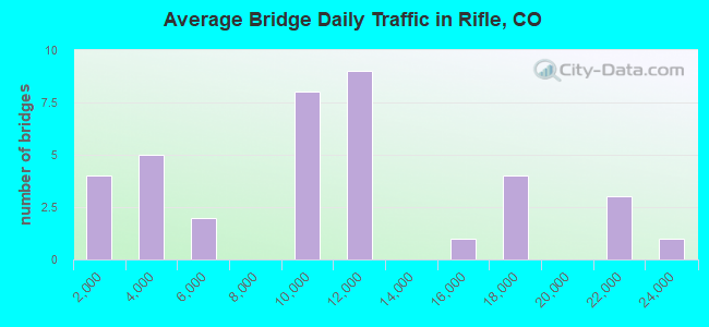
- 358,470Total average daily traffic
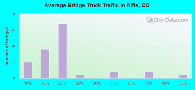
- 44,835Total average daily truck traffic
- National Bridge Inventory (NBI) Registered Bridges for Rifle
- No street view available for this location
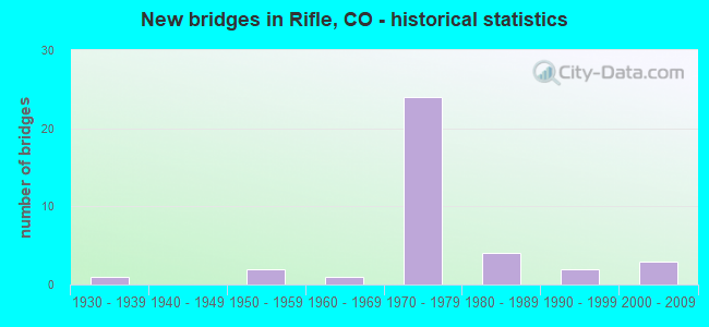
- New bridges - historical statistics
- 11930-1939
- 21950-1959
- 11960-1969
- 241970-1979
- 41980-1989
- 21990-1999
- 32000-2009
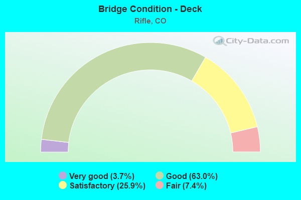
- Bridge Condition - Deck
- 3.7%Very good
- 63.0%Good
- 25.9%Satisfactory
- 7.4%Fair
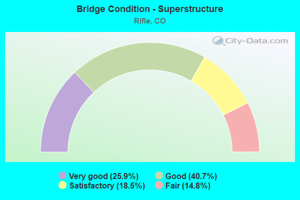
- Bridge Condition - Superstructure
- 25.9%Very good
- 40.7%Good
- 18.5%Satisfactory
- 14.8%Fair
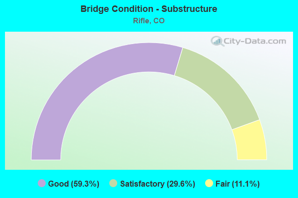
- Bridge Condition - Substructure
- 59.3%Good
- 29.6%Satisfactory
- 11.1%Fair
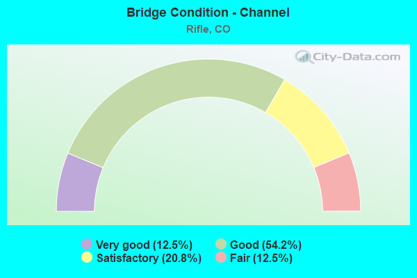
- Bridge Condition - Channel
- 12.5%Very good
- 54.2%Good
- 20.8%Satisfactory
- 12.5%Fair
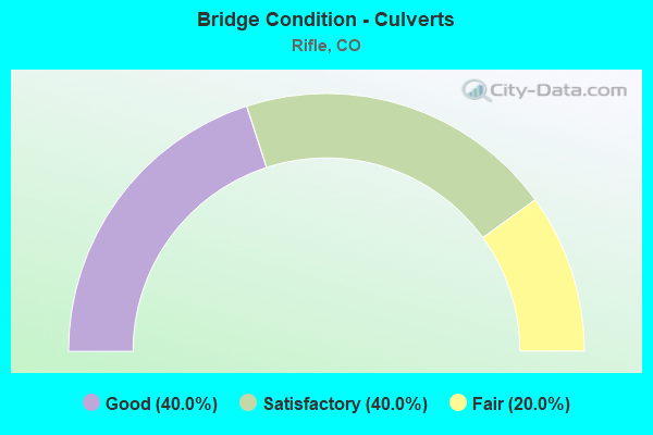
- Bridge Condition - Culverts
- 40.0%Good
- 40.0%Satisfactory
- 20.0%Fair
Find on map >> Show street view
Structure Number: 403-4, Location: Highway 325 Marker 4 (Lat: 39.627222, Lng: -107.757222), Route carried "on" structure: ServiceState highway 325, Year Built: 1965, Status: Posted for load, Structure Length: 0.83m (2.72ft), Average Daily Traffic: 510 (year 2018), Truck Traffic: 40%, Average Future Daily Traffic: 718 (year 2040), Design Load: HS 20, Features Intersected: Dam Spillway
Minimum Vertical Clearance: 30+ m (98+ ft), Kilometerpoint: 0.000, Lanes on structure: 2, Owner: Bureau of Reclamation, Maintenance Responsibility: State Highway Agency, Approaching Roadway Width: 8.5m (27.9ft), Skew: 1 degrees, Material/Design: Concrete, Design/Construction: Stringer/Multi-beam, Number Of Spans In Main Unit: 1, Length of Maximum Span: 7.6m (24.9ft), Curb or Sidewalk Widths: Left: 0.6m (2.0ft), Right: 0.6m (2.0ft), Curb-To-Curb Width: 7.3m (24.0ft), Out-to-Out Width: 8.5m (27.9ft)
Condition: Deck: Good, Superstructure: Good, Substructure: Good, Channel: Very good, Operating Rating: 38.6 metric tons, Method Used To Determine Operating Rating: Load and Resistance Factor Rating (LRFR) rating reported by rating factor(RF) method using HL-93 loadings, Inventory Rating: 29.8 metric tons, Method Used To Determine Inventory Rating: Load and Resistance Factor Rating (LRFR) rating reported by rating factor(RF) method using HL-93 loadings, Structural Evaluation: Better than present minimum criteria, Deck Geometry: Meets minimum limits, Waterway Adequacy: Superior to present desirable criteria, Approach Roadway Alignment: Equal to present minimum criteria, Designated Inspection Frequency: Every 24 months, Inspection Date: June 2020, Deck Structure Type: Concrete Cast-file-Place, Wearing Surface/Protective System: Wearing Surface: Gravel
Find on map >> Show street view
Structure Number: 16TH ST BRIDGE, Location: 0.3 Mi E, of RR Ave Rifle (Lat: 39.544183, Lng: -107.781653), Route carried "on" structure: City street , Year Built: 2000, Status: Open, Structure Length: 1.89m (6.20ft), Average Daily Traffic: 3,199 (year 2020), Truck Traffic: 16%, Average Future Daily Traffic: 4,063 (year 2040), Design Load: HS 20, Features Intersected: Rifle Creek, Facility Carried by Structure: 16th Street
Minimum Vertical Clearance: 30+ m (98+ ft), Kilometerpoint: 0.486, Lanes on structure: 2, Owner: City or Municipal Highway Agency, Approaching Roadway Width: 11.0m (36.1ft), Skew: 2 degrees, Material/Design: Steel, Design/Construction: Stringer/Multi-beam, Number Of Spans In Main Unit: 1, Length of Maximum Span: 17.5m (57.4ft), Curb or Sidewalk Widths: Left: 1.5m (4.9ft), Right: 1.5m (4.9ft), Curb-To-Curb Width: 9.8m (32.2ft), Out-to-Out Width: 13.7m (44.9ft)
Condition: Deck: Satisfactory, Superstructure: Satisfactory, Substructure: Good, Channel: Good, Operating Rating: 45.4 metric tons, Method Used To Determine Operating Rating: Load Factor (LF), Inventory Rating: 27.2 metric tons, Method Used To Determine Inventory Rating: Load Factor (LF), Structural Evaluation: Equal to present minimum criteria, Deck Geometry: Meets minimum limits, Waterway Adequacy: Better than present minimum criteria, Approach Roadway Alignment: Equal to present desirable criteria, Designated Inspection Frequency: Every 24 months, Inspection Date: September 2021, Deck Structure Type: Corrugated Steel, Wearing Surface/Protective System: Wearing Surface: Bituminous
Find on map >> Show street view
Structure Number: 3RD ST BRIDGE, Location: 2 Blocks W of RR Ave. (Lat: 39.531506, Lng: -107.785928), Route carried "on" structure: City street , Year Built: 1931, Year Reconstructed: 2008, Status: Open, Structure Length: 3.72m (12.20ft), Average Daily Traffic: 9,332 (year 2021), Truck Traffic: 16%, Average Future Daily Traffic: 11,852 (year 2041), Design Load: HS 20, Features Intersected: Rifle Creek, Facility Carried by Structure: Third Street
Minimum Vertical Clearance: 30+ m (98+ ft), Kilometerpoint: 0.220, Lanes on structure: 2, Owner: City or Municipal Highway Agency, Approaching Roadway Width: 18.3m (60.0ft), Material/Design: Steel, Design/Construction: Stringer/Multi-beam, Number Of Spans In Main Unit: 2, Length of Maximum Span: 17.5m (57.4ft), Curb or Sidewalk Widths: Left: 1.6m (5.2ft), Right: 1.5m (4.9ft), Curb-To-Curb Width: 8.6m (28.2ft), Out-to-Out Width: 12.8m (42.0ft)
Condition: Deck: Fair, Superstructure: Fair, Substructure: Satisfactory, Channel: Good, Operating Rating: 30.5 metric tons, Method Used To Determine Operating Rating: Load Factor (LF), Inventory Rating: 18.2 metric tons, Method Used To Determine Inventory Rating: Load Factor (LF), Structural Evaluation: Meets minimum limits, Deck Geometry: High priority of replacement, Waterway Adequacy: Better than present minimum criteria, Approach Roadway Alignment: Equal to present desirable criteria, Designated Inspection Frequency: Every 24 months, Inspection Date: September 2021, Deck Structure Type: Concrete Cast-file-Place, Wearing Surface/Protective System: Wearing Surface: Bituminous
Find on map >> Show street view
Structure Number: CREEKSIDE BRG, Location: 0.3 Mi E of RR Ave Rifle (Lat: 39.554461, Lng: -107.771044), Route carried "on" structure: City street , Year Built: 2006, Status: Open, Structure Length: 1.85m (6.07ft), Average Daily Traffic: 74 (year 2020), Truck Traffic: 16%, Average Future Daily Traffic: 94 (year 2040), Features Intersected: Rifle Creek, Facility Carried by Structure: Creekside Drive
Minimum Vertical Clearance: 30.45m (99.90ft), Kilometerpoint: 0.014, Lanes on structure: 2, Owner: City or Municipal Highway Agency, Approaching Roadway Width: 8.7m (28.5ft), Material/Design: Steel, Design/Construction: Stringer/Multi-beam, Number Of Spans In Main Unit: 1, Length of Maximum Span: 17.8m (58.4ft), Curb or Sidewalk Widths: Left: 2.8m (9.2ft), Right: 0.0m, Curb-To-Curb Width: 8.8m (28.9ft), Out-to-Out Width: 12.0m (39.4ft)
Condition: Deck: Good, Superstructure: Satisfactory, Substructure: Good, Channel: Satisfactory, Operating Rating: 41.5 metric tons, Method Used To Determine Operating Rating: Load Factor (LF), Inventory Rating: 24.9 metric tons, Method Used To Determine Inventory Rating: Load Factor (LF), Structural Evaluation: Equal to present minimum criteria, Deck Geometry: Better than present minimum criteria, Waterway Adequacy: Better than present minimum criteria, Approach Roadway Alignment: Equal to present minimum criteria, Designated Inspection Frequency: Every 24 months, Inspection Date: September 2021, Deck Structure Type: Corrugated Steel, Wearing Surface/Protective System: Wearing Surface: Bituminous
Find on map >> Show street view
Structure Number: F-05-AA, Location: 1.4 MI N OF JCT SH 6 (Lat: 39.546039, Lng: -107.792467), Route carried "on" structure: State highway 13A, Year Built: 1980, Status: Open, Structure Length: 0.76m (2.49ft), Average Daily Traffic: 5,700 (year 2020), Truck Traffic: 16%, Average Future Daily Traffic: 8,607 (year 2040), Design Load: HS 20, Features Intersected: HUBBARD GULCH, Facility Carried by Structure: SH 13 ML
Minimum Vertical Clearance: 30+ m (98+ ft), Kilometerpoint: 2.287, Lanes on structure: 2, Base Highway Network: Yes, Owner: State Highway Agency, Approaching Roadway Width: 11.6m (38.1ft), Material/Design: Concrete, Design/Construction: Culvert, Number Of Spans In Main Unit: 2, Length of Maximum Span: 3.7m (12.1ft), Out-to-Out Width: 21.9m (71.9ft)
Condition: Channel: Good, Culverts: Satisfactory, Operating Rating: 36.3 metric tons, Method Used To Determine Operating Rating: Field evaluation and documented engineering judgment, Inventory Rating: 32.7 metric tons, Method Used To Determine Inventory Rating: Field evaluation and documented engineering judgment, Structural Evaluation: Equal to present minimum criteria, Waterway Adequacy: Equal to present desirable criteria, Approach Roadway Alignment: Equal to present desirable criteria, Designated Inspection Frequency: Every 48 months, Inspection Date: June 2018
Find on map >> Show street view
Structure Number: F-05-AC, Location: 1.3 MI N OF JCT US 6-RIFL (Lat: 39.551608, Lng: -107.779242), Route carried "on" structure: State highway 13A, Year Built: 1987, Status: Open, Structure Length: 1.09m (3.58ft), Average Daily Traffic: 8,800 (year 2020), Truck Traffic: 7%, Average Future Daily Traffic: 11,352 (year 2040), Features Intersected: GOVERNMENT CREEK, Facility Carried by Structure: SH 13 ML
Minimum Vertical Clearance: 30+ m (98+ ft), Kilometerpoint: 3.700, Lanes on structure: 5, Base Highway Network: Yes, Owner: State Highway Agency, Approaching Roadway Width: 20.7m (67.9ft), Skew: 3 degrees, Material/Design: Steel, Design/Construction: Culvert, Number Of Spans In Main Unit: 2, Length of Maximum Span: 4.9m (16.1ft), Curb or Sidewalk Widths: Left: 0.0m, Right: 1.2m (3.9ft), Out-to-Out Width: 43.8m (143.7ft)
Condition: Channel: Satisfactory, Culverts: Good, Operating Rating: 96.9 metric tons, Method Used To Determine Operating Rating: Load and Resistance Factor Rating (LRFR) rating reported by rating factor(RF) method using HL-93 loadings, Inventory Rating: 96.9 metric tons, Method Used To Determine Inventory Rating: Load and Resistance Factor Rating (LRFR) rating reported by rating factor(RF) method using HL-93 loadings, Structural Evaluation: Better than present minimum criteria, Waterway Adequacy: Equal to present minimum criteria, Approach Roadway Alignment: Equal to present desirable criteria, Designated Inspection Frequency: Every 24 months, Inspection Date: July 2020
Find on map >> Show street view
Structure Number: F-05-C, Location: .4 MI WEST OF RR AVE (Lat: 39.528767, Lng: -107.789911), Route carried "on" structure: State highway , Year Built: 1954, Status: Open, Structure Length: 4.86m (15.94ft), Average Daily Traffic: 4,900 (year 2020), Truck Traffic: 33%, Average Future Daily Traffic: 6,223 (year 2040), Design Load: HS 20, Features Intersected: RIFLE CREEK, Facility Carried by Structure: CENTENNIAL PARKWAY
Minimum Vertical Clearance: 30+ m (98+ ft), Kilometerpoint: 0.590, Lanes on structure: 2, Base Highway Network: Yes, Owner: City or Municipal Highway Agency, Approaching Roadway Width: 9.1m (29.9ft), Skew: 3 degrees, Material/Design: Steel continuous, Design/Construction: Stringer/Multi-beam, Number Of Spans In Main Unit: 3, Length of Maximum Span: 18.0m (59.1ft), Curb-To-Curb Width: 9.8m (32.2ft), Out-to-Out Width: 10.7m (35.1ft)
Condition: Deck: Very good, Superstructure: Fair, Substructure: Good, Channel: Good, Operating Rating: 32.7 metric tons, Method Used To Determine Operating Rating: Load and Resistance Factor Rating (LRFR) rating reported by rating factor(RF) method using HL-93 loadings, Inventory Rating: 24.9 metric tons, Method Used To Determine Inventory Rating: Load and Resistance Factor Rating (LRFR) rating reported by rating factor(RF) method using HL-93 loadings, Structural Evaluation: Somewhat better than minimum adequacy, Deck Geometry: Meets minimum limits, Waterway Adequacy: Better than present minimum criteria, Approach Roadway Alignment: Equal to present desirable criteria, Length Of Structure Improvement: 1.01m (3.31ft), Designated Inspection Frequency: Every 24 months, Inspection Date: September 2021, Bridge Improvement Cost: $745,000, Roadway Improvement Cost: $75,000, Total Project Cost: $820,000 ( Estimate for 2017), Deck Structure Type: Concrete Cast-file-Place, Wearing Surface/Protective System: Wearing Surface: Epoxy Overlay
Find on map >> Show street view
Structure Number: F-05-D, Location: 36.2 MI E OF JCT SH 65 (Lat: 39.501753, Lng: -107.901606), Route carried "on" structure: ServiceInterstate 70A, Year Built: 1954, Status: Open, Structure Length: 1.34m (4.40ft), Average Daily Traffic: 20,000 (year 2020), Truck Traffic: 15%, Average Future Daily Traffic: 26,400 (year 2040), Design Load: HS 20, Features Intersected: DRAW SR, Facility Carried by Structure: I 70 SERVICE RD
Minimum Vertical Clearance: 30+ m (98+ ft), Kilometerpoint: 0.665, Lanes on structure: 2, Base Highway Network: Yes, Owner: State Highway Agency, Approaching Roadway Width: 7.9m (25.9ft), Material/Design: Concrete, Design/Construction: Culvert, Number Of Spans In Main Unit: 3, Length of Maximum Span: 4.9m (16.1ft), Out-to-Out Width: 13.7m (44.9ft)
Condition: Channel: Satisfactory, Culverts: Fair, Operating Rating: 36.3 metric tons, Method Used To Determine Operating Rating: Field evaluation and documented engineering judgment, Inventory Rating: 32.7 metric tons, Method Used To Determine Inventory Rating: Field evaluation and documented engineering judgment, Structural Evaluation: Somewhat better than minimum adequacy, Waterway Adequacy: Meets minimum limits, Approach Roadway Alignment: Equal to present desirable criteria, Designated Inspection Frequency: Every 24 months, Inspection Date: March 2020
Find on map >> Show street view
Structure Number: F-05-I, Location: 0.5 MI E of JCT 6 - RIFLE (Lat: 39.520081, Lng: -107.838347), Route carried "on" structure: Interstate 70A, Year Built: 1975, Status: Open, Structure Length: 6.29m (20.64ft), Average Daily Traffic: 8,500 (year 2020), Truck Traffic: 15%, Average Future Daily Traffic: 11,645 (year 2040), Design Load: HS 20+Mod, Features Intersected: UP RR, Facility Carried by Structure: I 70 ML EBND
Minimum Vertical Clearance: 30+ m (98+ ft), Kilometerpoint: 140.446, Lanes on structure: 3, Base Highway Network: Yes, Owner: State Highway Agency, Approaching Roadway Width: 19.2m (63.0ft), Skew: 15 degrees, Material/Design: Steel continuous, Design/Construction: Stringer/Multi-beam, Number Of Spans In Main Unit: 3, Length of Maximum Span: 24.4m (80.1ft), Curb-To-Curb Width: 15.8m (51.8ft), Out-to-Out Width: 16.6m (54.5ft)
Condition: Deck: Satisfactory, Superstructure: Good, Substructure: Good, Operating Rating: 54.3 metric tons, Method Used To Determine Operating Rating: Load Factor (LF), Inventory Rating: 32.5 metric tons, Method Used To Determine Inventory Rating: Load Factor (LF), Structural Evaluation: Better than present minimum criteria, Deck Geometry: Somewhat better than minimum adequacy, Underclear: Equal to present minimum criteria, Approach Roadway Alignment: Equal to present desirable criteria, Designated Inspection Frequency: Every 24 months, Inspection Date: July 2020, Deck Structure Type: Concrete Cast-file-Place, Wearing Surface/Protective System: Wearing Surface: Other, Membrane: Other
Find on map >> Show street view
Structure Number: F-05-J, Location: 3.3 MI W OF JCT SH 13 (RI (Lat: 39.520469, Lng: -107.837708), Route carried "on" structure: Interstate 70A, Year Built: 1975, Status: Open, Structure Length: 6.29m (20.64ft), Average Daily Traffic: 8,500 (year 2020), Truck Traffic: 15%, Average Future Daily Traffic: 11,645 (year 2040), Design Load: HS 20+Mod, Features Intersected: UP RR, Facility Carried by Structure: I 70 ML WBND
Minimum Vertical Clearance: 30+ m (98+ ft), Kilometerpoint: 140.501, Lanes on structure: 2, Base Highway Network: Yes, Owner: State Highway Agency, Approaching Roadway Width: 11.6m (38.1ft), Skew: 15 degrees, Material/Design: Steel continuous, Design/Construction: Stringer/Multi-beam, Number Of Spans In Main Unit: 3, Length of Maximum Span: 24.4m (80.1ft), Curb-To-Curb Width: 12.8m (42.0ft), Out-to-Out Width: 13.6m (44.6ft)
Condition: Deck: Satisfactory, Superstructure: Good, Substructure: Satisfactory, Operating Rating: 58.6 metric tons, Method Used To Determine Operating Rating: Load Factor (LF), Inventory Rating: 35.1 metric tons, Method Used To Determine Inventory Rating: Load Factor (LF), Structural Evaluation: Equal to present minimum criteria, Deck Geometry: Equal to present desirable criteria, Underclear: Equal to present minimum criteria, Approach Roadway Alignment: Equal to present desirable criteria, Designated Inspection Frequency: Every 24 months, Inspection Date: July 2020, Deck Structure Type: Concrete Cast-file-Place, Wearing Surface/Protective System: Wearing Surface: Other, Membrane: Other
Find on map >> Show street view
Structure Number: F-05-K, Location: 2 MI W OF JCT SH 13/RIFLE (Lat: 39.519958, Lng: -107.811594), Route carried "on" structure: Interstate 70A, Year Built: 1975, Status: Open, Structure Length: 15.38m (50.46ft), Average Daily Traffic: 8,500 (year 2020), Truck Traffic: 15%, Average Future Daily Traffic: 11,645 (year 2040), Design Load: HS 20+Mod, Features Intersected: COLORADO RIVER, Facility Carried by Structure: I 70 ML EBND
Minimum Vertical Clearance: 30+ m (98+ ft), Kilometerpoint: 142.746, Lanes on structure: 2, Base Highway Network: Yes, Owner: State Highway Agency, Approaching Roadway Width: 11.6m (38.1ft), Skew: 13 degrees, Material/Design: Steel continuous, Design/Construction: Stringer/Multi-beam, Number Of Spans In Main Unit: 5, Length of Maximum Span: 33.5m (109.9ft), Curb-To-Curb Width: 12.8m (42.0ft), Out-to-Out Width: 13.5m (44.3ft)
Condition: Deck: Satisfactory, Superstructure: Fair, Substructure: Satisfactory, Channel: Fair, Operating Rating: 56.9 metric tons, Method Used To Determine Operating Rating: Load Factor (LF), Inventory Rating: 34.1 metric tons, Method Used To Determine Inventory Rating: Load Factor (LF), Structural Evaluation: Somewhat better than minimum adequacy, Deck Geometry: Equal to present desirable criteria, Waterway Adequacy: Equal to present desirable criteria, Approach Roadway Alignment: Equal to present desirable criteria, Designated Inspection Frequency: Every 24 months, Underwater Inspection Frequency: Every 60 months, Inspection Date: October 2020, Underwater Inspection Date: September 2020, Deck Structure Type: Concrete Cast-file-Place, Wearing Surface/Protective System: Wearing Surface: Latex Concrete
Find on map >> Show street view
Structure Number: F-05-L, Location: 1.9 MI W OF JCT SH 13 (RI (Lat: 39.520319, Lng: -107.811272), Route carried "on" structure: Interstate 70A, Year Built: 1975, Status: Open, Structure Length: 15.39m (50.49ft), Average Daily Traffic: 8,500 (year 2020), Truck Traffic: 15%, Average Future Daily Traffic: 11,645 (year 2040), Design Load: HS 20+Mod, Features Intersected: COLORADO RIVER, Facility Carried by Structure: I 70 ML WBND
Minimum Vertical Clearance: 30+ m (98+ ft), Kilometerpoint: 142.773, Lanes on structure: 2, Base Highway Network: Yes, Owner: State Highway Agency, Approaching Roadway Width: 12.2m (40.0ft), Skew: 13 degrees, Material/Design: Steel continuous, Design/Construction: Stringer/Multi-beam, Number Of Spans In Main Unit: 5, Length of Maximum Span: 33.5m (109.9ft), Curb-To-Curb Width: 12.8m (42.0ft), Out-to-Out Width: 13.6m (44.6ft)
Condition: Deck: Fair, Superstructure: Fair, Substructure: Fair, Channel: Fair, Operating Rating: 44.4 metric tons, Method Used To Determine Operating Rating: Load Factor (LF), Inventory Rating: 26.6 metric tons, Method Used To Determine Inventory Rating: Load Factor (LF), Structural Evaluation: Somewhat better than minimum adequacy, Deck Geometry: Equal to present desirable criteria, Waterway Adequacy: Equal to present minimum criteria, Approach Roadway Alignment: Equal to present desirable criteria, Length Of Structure Improvement: 18.44m (60.50ft), Designated Inspection Frequency: Every 24 months, Underwater Inspection Frequency: Every 60 months, Inspection Date: October 2020, Underwater Inspection Date: September 2020, Bridge Improvement Cost: $7,417,000, Roadway Improvement Cost: $742,000, Total Project Cost: $11,125,000 ( Estimate for 2016), Deck Structure Type: Concrete Cast-file-Place, Wearing Surface/Protective System: Wearing Surface: Monolithic Concrete
Find on map >> Show street view
Structure Number: F-05-M, Location: 3.6 MI W OF JCT SH 13 (RI (Lat: 39.520494, Lng: -107.843886), Route carried "on" structure: Interstate 70A, Year Built: 1975, Status: Open, Structure Length: 4.22m (13.85ft), Average Daily Traffic: 10,000 (year 2020), Truck Traffic: 15%, Average Future Daily Traffic: 13,200 (year 2040), Design Load: HS 20+Mod, Features Intersected: US 6 ML, Facility Carried by Structure: I 70 ML WBND
Minimum Vertical Clearance: 30+ m (98+ ft), Kilometerpoint: 139.969, Lanes on structure: 2, Lanes under structure: 2, Base Highway Network: Yes, Owner: State Highway Agency, Approaching Roadway Width: 11.6m (38.1ft), Skew: 10 degrees, Material/Design: Concrete continuous, Design/Construction: Tee Beam, Number Of Spans In Main Unit: 3, Length of Maximum Span: 17.1m (56.1ft), Curb-To-Curb Width: 12.8m (42.0ft), Out-to-Out Width: 13.6m (44.6ft)
Condition: Deck: Satisfactory, Superstructure: Satisfactory, Substructure: Satisfactory, Operating Rating: 97.7 metric tons, Method Used To Determine Operating Rating: Load Factor (LF), Inventory Rating: 58.5 metric tons, Method Used To Determine Inventory Rating: Load Factor (LF), Structural Evaluation: Equal to present minimum criteria, Deck Geometry: Equal to present desirable criteria, Underclear: Superior to present desirable criteria, Approach Roadway Alignment: Equal to present desirable criteria, Designated Inspection Frequency: Every 48 months, Inspection Date: June 2018, Deck Structure Type: Concrete Cast-file-Place, Wearing Surface/Protective System: Wearing Surface: Other, Membrane: Other
Find on map >> Show street view
Structure Number: F-05-N, Location: 3.6 mi W of SH13, RIFLE (Lat: 39.520136, Lng: -107.843856), Route carried "on" structure: Interstate 70A, Year Built: 1975, Status: Open, Structure Length: 4.22m (13.85ft), Average Daily Traffic: 10,000 (year 2020), Truck Traffic: 15%, Average Future Daily Traffic: 13,200 (year 2040), Design Load: HS 20+Mod, Features Intersected: US 6 ML, Facility Carried by Structure: I 70 ML EBND
Minimum Vertical Clearance: 5.16m (16.93ft), Kilometerpoint: 139.973, Lanes on structure: 2, Lanes under structure: 2, Base Highway Network: Yes, Owner: State Highway Agency, Approaching Roadway Width: 11.6m (38.1ft), Skew: 10 degrees, Material/Design: Concrete continuous, Design/Construction: Tee Beam, Number Of Spans In Main Unit: 3, Length of Maximum Span: 17.1m (56.1ft), Curb-To-Curb Width: 12.8m (42.0ft), Out-to-Out Width: 13.6m (44.6ft)
Condition: Deck: Good, Superstructure: Good, Substructure: Good, Operating Rating: 98.1 metric tons, Method Used To Determine Operating Rating: Load Factor (LF), Inventory Rating: 58.7 metric tons, Method Used To Determine Inventory Rating: Load Factor (LF), Structural Evaluation: Better than present minimum criteria, Deck Geometry: Equal to present desirable criteria, Underclear: Equal to present desirable criteria, Approach Roadway Alignment: Equal to present desirable criteria, Designated Inspection Frequency: Every 24 months, Inspection Date: July 2020, Deck Structure Type: Concrete Cast-file-Place, Wearing Surface/Protective System: Wearing Surface: Other, Membrane: Other
Find on map >> Show street view
Structure Number: F-05-O, Location: 4.6 MI W OF JCT SILT SPUR (Lat: 39.524047, Lng: -107.777808), Route carried "on" structure: Interstate 70A, Year Built: 1975, Status: Open, Structure Length: 5.75m (18.86ft), Average Daily Traffic: 8,500 (year 2020), Truck Traffic: 15%, Average Future Daily Traffic: 11,645 (year 2040), Design Load: HS 20+Mod, Features Intersected: SH 13 ML, Facility Carried by Structure: I 70 ML WBND
Minimum Vertical Clearance: 30+ m (98+ ft), Kilometerpoint: 145.733, Lanes on structure: 2, Lanes under structure: 4, Base Highway Network: Yes, Owner: State Highway Agency, Approaching Roadway Width: 11.6m (38.1ft), Material/Design: Prestressed concrete continuous, Design/Construction: Stringer/Multi-beam, Number Of Spans In Main Unit: 2, Length of Maximum Span: 28.0m (91.9ft), Curb-To-Curb Width: 12.8m (42.0ft), Out-to-Out Width: 13.6m (44.6ft)
Condition: Deck: Good, Superstructure: Good, Substructure: Good, Operating Rating: 45.4 metric tons, Method Used To Determine Operating Rating: Load Factor (LF), Inventory Rating: 26.3 metric tons, Method Used To Determine Inventory Rating: Load Factor (LF), Structural Evaluation: Equal to present minimum criteria, Deck Geometry: Equal to present desirable criteria, Underclear: Better than present minimum criteria, Approach Roadway Alignment: Equal to present desirable criteria, Designated Inspection Frequency: Every 24 months, Inspection Date: July 2020, Deck Structure Type: Concrete Cast-file-Place, Wearing Surface/Protective System: Wearing Surface: Other, Membrane: Other
Find on map >> Show street view
Structure Number: F-05-P, Location: RIFLE INTERCHANGE (Lat: 39.523711, Lng: -107.777647), Route carried "on" structure: Interstate 70A, Year Built: 1975, Status: Open, Structure Length: 5.75m (18.86ft), Average Daily Traffic: 8,500 (year 2020), Truck Traffic: 15%, Average Future Daily Traffic: 11,645 (year 2040), Design Load: HS 20+Mod, Features Intersected: SH 13 ML, Facility Carried by Structure: I 70 ML EBND
Minimum Vertical Clearance: 30+ m (98+ ft), Kilometerpoint: 145.733, Lanes on structure: 2, Lanes under structure: 4, Base Highway Network: Yes, Owner: State Highway Agency, Approaching Roadway Width: 11.6m (38.1ft), Material/Design: Prestressed concrete continuous, Design/Construction: Stringer/Multi-beam, Number Of Spans In Main Unit: 2, Length of Maximum Span: 28.0m (91.9ft), Curb-To-Curb Width: 12.8m (42.0ft), Out-to-Out Width: 13.6m (44.6ft)
Condition: Deck: Satisfactory, Superstructure: Good, Substructure: Satisfactory, Operating Rating: 43.5 metric tons, Method Used To Determine Operating Rating: Load Factor (LF), Inventory Rating: 26.1 metric tons, Method Used To Determine Inventory Rating: Load Factor (LF), Structural Evaluation: Equal to present minimum criteria, Deck Geometry: Equal to present desirable criteria, Underclear: Better than present minimum criteria, Approach Roadway Alignment: Equal to present desirable criteria, Designated Inspection Frequency: Every 24 months, Inspection Date: July 2020, Deck Structure Type: Concrete Cast-file-Place, Wearing Surface/Protective System: Wearing Surface: Other, Membrane: Other
Find on map >> Show street view
Structure Number: F-05-Q, Location: 0.3 MI N OF JCT I70 (Lat: 39.528333, Lng: -107.779700), Route carried "on" structure: State highway 13A, Year Built: 1976, Status: Open, Structure Length: 7.29m (23.92ft), Average Daily Traffic: 17,000 (year 2018), Truck Traffic: 6%, Average Future Daily Traffic: 21,590 (year 2038), Design Load: HS 20+Mod, Features Intersected: UP RR, Facility Carried by Structure: SH 13 ML
Minimum Vertical Clearance: 30+ m (98+ ft), Kilometerpoint: 0.351, Lanes on structure: 5, Base Highway Network: Yes, Owner: State Highway Agency, Approaching Roadway Width: 22.6m (74.1ft), Skew: 23 degrees, Material/Design: Steel continuous, Design/Construction: Stringer/Multi-beam, Number Of Spans In Main Unit: 3, Length of Maximum Span: 27.1m (88.9ft), Curb or Sidewalk Widths: Left: 2.4m (7.9ft), Right: 0.0m, Curb-To-Curb Width: 22.6m (74.1ft), Out-to-Out Width: 25.8m (84.6ft)
Condition: Deck: Good, Superstructure: Good, Substructure: Good, Operating Rating: 52.6 metric tons, Method Used To Determine Operating Rating: Load Factor (LF), Inventory Rating: 31.8 metric tons, Method Used To Determine Inventory Rating: Load Factor (LF), Structural Evaluation: Better than present minimum criteria, Deck Geometry: Equal to present minimum criteria, Underclear: Equal to present minimum criteria, Approach Roadway Alignment: Better than present minimum criteria, Designated Inspection Frequency: Every 48 months, Inspection Date: June 2018, Deck Structure Type: Concrete Cast-file-Place, Wearing Surface/Protective System: Wearing Surface: Bituminous
Find on map >> Show street view
Structure Number: F-05-R, Location: 0.2 MI N OF JCT I70 (Lat: 39.525714, Lng: -107.778075), Route carried "on" structure: State highway 13A, Year Built: 1976, Status: Open, Structure Length: 13.57m (44.52ft), Average Daily Traffic: 17,000 (year 2018), Truck Traffic: 6%, Average Future Daily Traffic: 21,590 (year 2038), Design Load: HS 20, Features Intersected: COLORADO RIVER, Facility Carried by Structure: SH 13 ML
Minimum Vertical Clearance: 30+ m (98+ ft), Kilometerpoint: 0.030, Lanes on structure: 4, Owner: State Highway Agency, Approaching Roadway Width: 22.3m (73.2ft), Skew: 22 degrees, Material/Design: Prestressed concrete continuous, Design/Construction: Stringer/Multi-beam, Number Of Spans In Main Unit: 5, Length of Maximum Span: 27.4m (89.9ft), Curb or Sidewalk Widths: Left: 2.4m (7.9ft), Right: 0.0m, Curb-To-Curb Width: 20.7m (67.9ft), Out-to-Out Width: 25.0m (82.0ft)
Condition: Deck: Satisfactory, Superstructure: Satisfactory, Substructure: Fair, Channel: Fair, Operating Rating: 60.4 metric tons, Method Used To Determine Operating Rating: Load Factor (LF), Inventory Rating: 36.2 metric tons, Method Used To Determine Inventory Rating: Load Factor (LF), Structural Evaluation: Somewhat better than minimum adequacy, Deck Geometry: Superior to present desirable criteria, Waterway Adequacy: Equal to present desirable criteria, Approach Roadway Alignment: Equal to present desirable criteria, Designated Inspection Frequency: Every 24 months, Underwater Inspection Frequency: Every 60 months, Inspection Date: October 2020, Underwater Inspection Date: September 2020, Deck Structure Type: Concrete Cast-file-Place, Wearing Surface/Protective System: Wearing Surface: Bituminous
Find on map >> Show street view
Structure Number: F-05-T, Location: 34.4 MI E OF JCT SH 65 (Lat: 39.502572, Lng: -107.901536), Route carried "on" structure: Interstate 70A, Year Built: 1977, Status: Open, Structure Length: 0.68m (2.23ft), Average Daily Traffic: 10,000 (year 2020), Truck Traffic: 15%, Average Future Daily Traffic: 13,200 (year 2040), Design Load: HS 20, Features Intersected: DRAW, Facility Carried by Structure: I 70 ML EBND
Minimum Vertical Clearance: 30+ m (98+ ft), Kilometerpoint: 134.593, Lanes on structure: 2, Base Highway Network: Yes, Owner: State Highway Agency, Approaching Roadway Width: 11.6m (38.1ft), Skew: 12 degrees, Material/Design: Concrete, Design/Construction: Culvert, Number Of Spans In Main Unit: 2, Length of Maximum Span: 3.2m (10.5ft), Out-to-Out Width: 40.7m (133.5ft)
Condition: Channel: Good, Culverts: Good, Operating Rating: 36.3 metric tons, Method Used To Determine Operating Rating: Field evaluation and documented engineering judgment, Inventory Rating: 32.7 metric tons, Method Used To Determine Inventory Rating: Field evaluation and documented engineering judgment, Structural Evaluation: Better than present minimum criteria, Waterway Adequacy: Equal to present minimum criteria, Approach Roadway Alignment: Equal to present desirable criteria, Designated Inspection Frequency: Every 48 months, Inspection Date: March 2018
Find on map >> Show street view
Structure Number: F-05-U, Location: 7.0 MI W OF JCT SH 13 (Lat: 39.503672, Lng: -107.901519), Route carried "on" structure: Interstate 70A, Year Built: 1977, Status: Open, Structure Length: 0.69m (2.26ft), Average Daily Traffic: 10,000 (year 2020), Truck Traffic: 15%, Average Future Daily Traffic: 13,200 (year 2040), Design Load: HS 20, Features Intersected: DRAW, Facility Carried by Structure: I 70 ML WBND
Minimum Vertical Clearance: 30+ m (98+ ft), Kilometerpoint: 134.638, Lanes on structure: 4, Base Highway Network: Yes, Owner: State Highway Agency, Approaching Roadway Width: 11.6m (38.1ft), Skew: 12 degrees, Material/Design: Concrete, Design/Construction: Culvert, Number Of Spans In Main Unit: 2, Length of Maximum Span: 3.3m (10.8ft), Out-to-Out Width: 61.6m (202.1ft)
Condition: Channel: Good, Culverts: Satisfactory, Operating Rating: 81.6 metric tons, Method Used To Determine Operating Rating: Field evaluation and documented engineering judgment, Inventory Rating: 72.7 metric tons, Method Used To Determine Inventory Rating: Field evaluation and documented engineering judgment, Structural Evaluation: Equal to present minimum criteria, Waterway Adequacy: Equal to present desirable criteria, Approach Roadway Alignment: Equal to present desirable criteria, Designated Inspection Frequency: Every 48 months, Inspection Date: March 2018
Find on map >> Show street view
Structure Number: F-06-AA, Location: 2.5 Mi E of RIFLE (Lat: 39.527089, Lng: -107.746525), Route carried "on" structure: Interstate 70A, Year Built: 1975, Status: Open, Structure Length: 2.51m (8.23ft), Average Daily Traffic: 10,500 (year 2020), Truck Traffic: 11%, Average Future Daily Traffic: 13,965 (year 2040), Design Load: HS 20+Mod, Features Intersected: DRY CREEK, Facility Carried by Structure: I 70 ML EBND
Minimum Vertical Clearance: 30+ m (98+ ft), Kilometerpoint: 148.510, Lanes on structure: 2, Base Highway Network: Yes, Owner: State Highway Agency, Approaching Roadway Width: 11.6m (38.1ft), Skew: 10 degrees, Material/Design: Prestressed concrete, Design/Construction: Stringer/Multi-beam, Number Of Spans In Main Unit: 1, Length of Maximum Span: 24.4m (80.1ft), Curb-To-Curb Width: 12.8m (42.0ft), Out-to-Out Width: 13.6m (44.6ft)
Condition: Deck: Good, Superstructure: Good, Substructure: Good, Channel: Good, Operating Rating: 42.2 metric tons, Method Used To Determine Operating Rating: Load Factor (LF), Inventory Rating: 25.2 metric tons, Method Used To Determine Inventory Rating: Load Factor (LF), Structural Evaluation: Equal to present minimum criteria, Deck Geometry: Equal to present desirable criteria, Waterway Adequacy: Equal to present desirable criteria, Approach Roadway Alignment: Equal to present desirable criteria, Designated Inspection Frequency: Every 24 months, Inspection Date: July 2020, Deck Structure Type: Concrete Cast-file-Place, Wearing Surface/Protective System: Wearing Surface: Other, Membrane: Other
Find on map >> Show street view
Structure Number: F-06-AB, Location: 2.5 MI E of RIFLE (Lat: 39.527414, Lng: -107.746717), Route carried "on" structure: Interstate 70A, Year Built: 1975, Status: Open, Structure Length: 2.51m (8.23ft), Average Daily Traffic: 10,500 (year 2020), Truck Traffic: 11%, Average Future Daily Traffic: 13,965 (year 2040), Design Load: HS 20+Mod, Features Intersected: DRY CREEK, Facility Carried by Structure: I 70 ML WBND
Minimum Vertical Clearance: 30+ m (98+ ft), Kilometerpoint: 148.510, Lanes on structure: 2, Base Highway Network: Yes, Owner: State Highway Agency, Approaching Roadway Width: 11.6m (38.1ft), Skew: 10 degrees, Material/Design: Prestressed concrete, Design/Construction: Stringer/Multi-beam, Number Of Spans In Main Unit: 1, Length of Maximum Span: 24.4m (80.1ft), Curb-To-Curb Width: 12.8m (42.0ft), Out-to-Out Width: 13.6m (44.6ft)
Condition: Deck: Good, Superstructure: Very good, Substructure: Good, Channel: Very good, Operating Rating: 42.2 metric tons, Method Used To Determine Operating Rating: Load Factor (LF), Inventory Rating: 25.2 metric tons, Method Used To Determine Inventory Rating: Load Factor (LF), Structural Evaluation: Equal to present minimum criteria, Deck Geometry: Equal to present desirable criteria, Waterway Adequacy: Equal to present desirable criteria, Approach Roadway Alignment: Equal to present desirable criteria, Designated Inspection Frequency: Every 24 months, Inspection Date: July 2020, Deck Structure Type: Concrete Cast-file-Place, Wearing Surface/Protective System: Wearing Surface: Other, Membrane: Other
Find on map >> Show street view
Structure Number: F-06-AC, Location: 2.5 MI OF RIFLE (Lat: 39.527692, Lng: -107.746889), Route carried "on" structure: ServiceInterstate 70A, Year Built: 1975, Status: Open, Structure Length: 2.06m (6.76ft), Average Daily Traffic: 21,000 (year 2020), Truck Traffic: 11%, Average Future Daily Traffic: 27,930 (year 2040), Design Load: HS 20+Mod, Features Intersected: DRY CREEK SR, Facility Carried by Structure: I 70 FRONTAGE RD
Minimum Vertical Clearance: 30+ m (98+ ft), Kilometerpoint: 0.562, Lanes on structure: 2, Base Highway Network: Yes, Owner: State Highway Agency, Approaching Roadway Width: 7.3m (24.0ft), Skew: 10 degrees, Material/Design: Prestressed concrete, Design/Construction: Stringer/Multi-beam, Number Of Spans In Main Unit: 1, Length of Maximum Span: 19.8m (65.0ft), Curb-To-Curb Width: 8.5m (27.9ft), Out-to-Out Width: 9.3m (30.5ft)
Condition: Deck: Good, Superstructure: Very good, Substructure: Good, Channel: Satisfactory, Operating Rating: 66.0 metric tons, Method Used To Determine Operating Rating: Load Factor (LF), Inventory Rating: 37.1 metric tons, Method Used To Determine Inventory Rating: Load Factor (LF), Structural Evaluation: Better than present minimum criteria, Deck Geometry: High priority of replacement, Waterway Adequacy: Equal to present desirable criteria, Approach Roadway Alignment: Equal to present desirable criteria, Designated Inspection Frequency: Every 24 months, Inspection Date: July 2020, Deck Structure Type: Concrete Cast-file-Place, Wearing Surface/Protective System: Wearing Surface: Bituminous
Find on map >> Show street view
Structure Number: F-06-AD, Location: 4.5MI E OF RIFLE (Lat: 39.531772, Lng: -107.714033), Route carried "on" structure: Interstate 70A, Year Built: 1977, Status: Open, Structure Length: 2.15m (7.05ft), Average Daily Traffic: 10,500 (year 2020), Truck Traffic: 11%, Average Future Daily Traffic: 13,965 (year 2040), Design Load: HS 20+Mod, Features Intersected: MAMM CREEK, Facility Carried by Structure: I 70 ML EBND
Minimum Vertical Clearance: 30+ m (98+ ft), Kilometerpoint: 151.383, Lanes on structure: 2, Base Highway Network: Yes, Owner: State Highway Agency, Approaching Roadway Width: 11.6m (38.1ft), Skew: 10 degrees, Material/Design: Prestressed concrete, Design/Construction: Stringer/Multi-beam, Number Of Spans In Main Unit: 1, Length of Maximum Span: 20.0m (65.6ft), Curb-To-Curb Width: 13.0m (42.7ft), Out-to-Out Width: 13.6m (44.6ft)
Condition: Deck: Good, Superstructure: Very good, Substructure: Good, Channel: Good, Operating Rating: 60.4 metric tons, Method Used To Determine Operating Rating: Load Factor (LF), Inventory Rating: 30.0 metric tons, Method Used To Determine Inventory Rating: Load Factor (LF), Structural Evaluation: Better than present minimum criteria, Deck Geometry: Superior to present desirable criteria, Waterway Adequacy: Equal to present desirable criteria, Approach Roadway Alignment: Equal to present desirable criteria, Designated Inspection Frequency: Every 48 months, Inspection Date: July 2020, Deck Structure Type: Concrete Cast-file-Place, Wearing Surface/Protective System: Wearing Surface: Other, Membrane: Other
Find on map >> Show street view
Structure Number: F-06-AE, Location: 4.5MI E OF RIFLE (Lat: 39.532122, Lng: -107.714036), Route carried "on" structure: Interstate 70A, Year Built: 1977, Status: Open, Structure Length: 2.16m (7.09ft), Average Daily Traffic: 10,500 (year 2020), Truck Traffic: 11%, Average Future Daily Traffic: 13,965 (year 2040), Design Load: HS 20, Features Intersected: MAMM CREEK, Facility Carried by Structure: I 70 ML WBND
Minimum Vertical Clearance: 30+ m (98+ ft), Kilometerpoint: 151.383, Lanes on structure: 2, Base Highway Network: Yes, Owner: State Highway Agency, Approaching Roadway Width: 11.6m (38.1ft), Skew: 10 degrees, Material/Design: Prestressed concrete, Design/Construction: Stringer/Multi-beam, Number Of Spans In Main Unit: 1, Length of Maximum Span: 21.0m (68.9ft), Curb-To-Curb Width: 12.8m (42.0ft), Out-to-Out Width: 13.6m (44.6ft)
Condition: Deck: Good, Superstructure: Very good, Substructure: Good, Channel: Very good, Operating Rating: 60.4 metric tons, Method Used To Determine Operating Rating: Load Factor (LF), Inventory Rating: 30.0 metric tons, Method Used To Determine Inventory Rating: Load Factor (LF), Structural Evaluation: Better than present minimum criteria, Deck Geometry: Equal to present desirable criteria, Waterway Adequacy: Equal to present desirable criteria, Approach Roadway Alignment: Equal to present desirable criteria, Designated Inspection Frequency: Every 48 months, Inspection Date: July 2020, Deck Structure Type: Concrete Cast-file-Place, Wearing Surface/Protective System: Wearing Surface: Other, Membrane: Other
Find on map >> Show street view
Structure Number: F-06-AF, Location: 4.5MI E OF RIFLE (Lat: 39.532747, Lng: -107.714394), Route carried "on" structure: Ramp Interstate 70A, Year Built: 1977, Status: Open, Structure Length: 3.12m (10.24ft), Average Daily Traffic: 10,500 (year 2020), Truck Traffic: 11%, Average Future Daily Traffic: 13,965 (year 2040), Design Load: HS 20+Mod, Features Intersected: MAMM CREEK, Facility Carried by Structure: RAMP TO I 70 WBND
Minimum Vertical Clearance: 30+ m (98+ ft), Kilometerpoint: 0.129, Lanes on structure: 1, Base Highway Network: Yes, Owner: State Highway Agency, Approaching Roadway Width: 7.3m (24.0ft), Skew: 2 degrees, Material/Design: Prestressed concrete, Design/Construction: Stringer/Multi-beam, Number Of Spans In Main Unit: 1, Length of Maximum Span: 30.2m (99.1ft), Curb-To-Curb Width: 8.5m (27.9ft), Out-to-Out Width: 9.3m (30.5ft)
Condition: Deck: Good, Superstructure: Very good, Substructure: Good, Channel: Good, Operating Rating: 71.2 metric tons, Method Used To Determine Operating Rating: Load Factor (LF), Inventory Rating: 38.4 metric tons, Method Used To Determine Inventory Rating: Load Factor (LF), Structural Evaluation: Better than present minimum criteria, Deck Geometry: Superior to present desirable criteria, Waterway Adequacy: Equal to present desirable criteria, Approach Roadway Alignment: Equal to present desirable criteria, Designated Inspection Frequency: Every 24 months, Inspection Date: July 2020, Deck Structure Type: Concrete Cast-file-Place, Wearing Surface/Protective System: Wearing Surface: Bituminous, Membrane: Built-up
Find on map >> Show street view
Structure Number: F-06-AG, Location: 4.5MI E OF RIFLE (Lat: 39.531600, Lng: -107.712883), Route carried "on" structure: County highway , Year Built: 1977, Status: Open, Structure Length: 8.43m (27.66ft), Average Daily Traffic: 3,105 (year 2008), Truck Traffic: 50%, Average Future Daily Traffic: 6,521 (year 2028), Design Load: HS 20, Features Intersected: I 70 ML, Facility Carried by Structure: COUNTY ROAD
Minimum Vertical Clearance: 30+ m (98+ ft), Kilometerpoint: 0.101, Lanes on structure: 2, Lanes under structure: 4, Owner: State Highway Agency, Approaching Roadway Width: 11.0m (36.1ft), Material/Design: Prestressed concrete continuous, Design/Construction: Box Beam or Girders - Single/Spread, Number Of Spans In Main Unit: 2, Length of Maximum Span: 41.8m (137.1ft), Curb-To-Curb Width: 11.0m (36.1ft), Out-to-Out Width: 11.7m (38.4ft)
Condition: Deck: Good, Superstructure: Satisfactory, Substructure: Satisfactory, Operating Rating: 64.8 metric tons, Method Used To Determine Operating Rating: Load and Resistance Factor Rating (LRFR) rating reported by rating factor(RF) method using HL-93 loadings, Inventory Rating: 48.6 metric tons, Method Used To Determine Inventory Rating: Load and Resistance Factor Rating (LRFR) rating reported by rating factor(RF) method using HL-93 loadings, Structural Evaluation: Equal to present minimum criteria, Deck Geometry: Somewhat better than minimum adequacy, Underclear: Better than present minimum criteria, Approach Roadway Alignment: Equal to present desirable criteria, Designated Inspection Frequency: Every 24 months, Inspection Date: July 2020, Deck Structure Type: Concrete Cast-file-Place, Wearing Surface/Protective System: Wearing Surface: Bituminous
Find on map >> Show street view
Structure Number: F-06-AH, Location: 3.4 M E OF RIFLE CITY LIM (Lat: 39.531361, Lng: -107.714067), Route carried "on" structure: Ramp Interstate 70A, Year Built: 1984, Status: Open, Structure Length: 3.40m (11.15ft), Average Daily Traffic: 21,000 (year 2020), Truck Traffic: 11%, Average Future Daily Traffic: 27,930 (year 2040), Design Load: HS 20+Mod, Features Intersected: MAMM CREEK R, Facility Carried by Structure: RMP TO FRONTAGE RD
Minimum Vertical Clearance: 30+ m (98+ ft), Kilometerpoint: 0.399, Lanes on structure: 1, Base Highway Network: Yes, Owner: State Highway Agency, Approaching Roadway Width: 7.9m (25.9ft), Skew: 12 degrees, Material/Design: Prestressed concrete, Design/Construction: Stringer/Multi-beam, Number Of Spans In Main Unit: 1, Length of Maximum Span: 33.2m (108.9ft), Curb-To-Curb Width: 7.6m (24.9ft), Out-to-Out Width: 8.4m (27.6ft)
Condition: Deck: Good, Superstructure: Very good, Substructure: Satisfactory, Channel: Good, Operating Rating: 69.8 metric tons, Method Used To Determine Operating Rating: Load Factor (LF), Inventory Rating: 32.1 metric tons, Method Used To Determine Inventory Rating: Load Factor (LF), Structural Evaluation: Equal to present minimum criteria, Deck Geometry: Better than present minimum criteria, Waterway Adequacy: Equal to present desirable criteria, Approach Roadway Alignment: Equal to present desirable criteria, Designated Inspection Frequency: Every 24 months, Inspection Date: July 2020, Deck Structure Type: Concrete Cast-file-Place, Wearing Surface/Protective System: Wearing Surface: Bituminous, Membrane: Preformed Fabric
Find on map >> Show street view
Structure Number: GAR315-07.20-A, Location: 5.2 Mi South of I-70 (Lat: 39.468056, Lng: -107.688056), Route carried "on" structure: County highway , Year Built: 1993, Status: Open, Structure Length: 0.81m (2.66ft), Average Daily Traffic: 148 (year 2020), Truck Traffic: 41%, Average Future Daily Traffic: 188 (year 2040), Design Load: HS 20, Features Intersected: Mamm Creek, Facility Carried by Structure: County Road 315
Minimum Vertical Clearance: 30+ m (98+ ft), Kilometerpoint: 8.196, Lanes on structure: 2, Owner: County Highway Agency, Approaching Roadway Width: 7.6m (24.9ft), Skew: 1 degrees, Material/Design: Concrete, Design/Construction: Slab, Number Of Spans In Main Unit: 1, Length of Maximum Span: 7.6m (24.9ft), Curb-To-Curb Width: 8.9m (29.2ft), Out-to-Out Width: 9.8m (32.2ft)
Condition: Deck: Good, Superstructure: Good, Substructure: Fair, Channel: Satisfactory, Operating Rating: 71.8 metric tons, Method Used To Determine Operating Rating: Load Factor (LF), Inventory Rating: 43.1 metric tons, Method Used To Determine Inventory Rating: Load Factor (LF), Structural Evaluation: Somewhat better than minimum adequacy, Deck Geometry: Equal to present minimum criteria, Waterway Adequacy: Better than present minimum criteria, Approach Roadway Alignment: Equal to present minimum criteria, Designated Inspection Frequency: Every 24 months, Inspection Date: September 2021, Deck Structure Type: Concrete Cast-file-Place, Wearing Surface/Protective System: Wearing Surface: Bituminous
Find on map >> Show street view
Structure Number: GAR346-03.10-A, Location: 300 Ft. South of I-70 (Lat: 39.530556, Lng: -107.713611), Route carried "on" structure: County highway , Year Built: 1999, Status: Open, Structure Length: 0.91m (2.99ft), Average Daily Traffic: 1,379 (year 2020), Truck Traffic: 31%, Average Future Daily Traffic: 1,751 (year 2040), Design Load: HS 20, Features Intersected: Mamm Creek, Facility Carried by Structure: County Road 346
Minimum Vertical Clearance: 30+ m (98+ ft), Kilometerpoint: 3.143, Lanes on structure: 2, Owner: County Highway Agency, Approaching Roadway Width: 7.3m (24.0ft), Material/Design: Wood or Timber, Design/Construction: Slab, Number Of Spans In Main Unit: 1, Length of Maximum Span: 8.5m (27.9ft), Curb-To-Curb Width: 8.6m (28.2ft), Out-to-Out Width: 9.2m (30.2ft)
Condition: Deck: Good, Superstructure: Good, Substructure: Satisfactory, Channel: Good, Operating Rating: 39.9 metric tons, Method Used To Determine Operating Rating: Allowable Stress (AS), Inventory Rating: 26.0 metric tons, Method Used To Determine Inventory Rating: Allowable Stress (AS), Structural Evaluation: Equal to present minimum criteria, Deck Geometry: Somewhat better than minimum adequacy, Waterway Adequacy: Equal to present desirable criteria, Approach Roadway Alignment: Equal to present desirable criteria, Designated Inspection Frequency: Every 24 months, Inspection Date: September 2021, Deck Structure Type: Wood or Timber, Wearing Surface/Protective System: Wearing Surface: Bituminous, Deck Protection: Internally Sealed
Find on map >> Show street view
Structure Number: RAILROAD BRG-A, Location: 100' N of 9th St (Rif (Lat: 39.538056, Lng: -107.783361), Route carried "on" structure: City street , Year Built: 1989, Status: Open, Structure Length: 4.45m (14.60ft), Average Daily Traffic: 15,113 (year 2020), Truck Traffic: 11%, Average Future Daily Traffic: 19,194 (year 2040), Design Load: HS 20, Features Intersected: Rifle Creek, Facility Carried by Structure: Railroad Avenue
Minimum Vertical Clearance: 30+ m (98+ ft), Kilometerpoint: 0.937, Lanes on structure: 3, Owner: City or Municipal Highway Agency, Approaching Roadway Width: 14.3m (46.9ft), Material/Design: Prestressed concrete, Design/Construction: Tee Beam, Number Of Spans In Main Unit: 2, Length of Maximum Span: 20.8m (68.2ft), Curb or Sidewalk Widths: Left: 2.3m (7.5ft), Right: 1.3m (4.3ft), Curb-To-Curb Width: 14.7m (48.2ft), Out-to-Out Width: 19.0m (62.3ft)
Condition: Deck: Good, Superstructure: Good, Substructure: Good, Channel: Good, Operating Rating: 44.0 metric tons, Method Used To Determine Operating Rating: Load Factor (LF), Inventory Rating: 23.7 metric tons, Method Used To Determine Inventory Rating: Load Factor (LF), Structural Evaluation: Somewhat better than minimum adequacy, Deck Geometry: Somewhat better than minimum adequacy, Waterway Adequacy: Equal to present desirable criteria, Approach Roadway Alignment: Equal to present desirable criteria, Designated Inspection Frequency: Every 24 months, Inspection Date: September 2021, Deck Structure Type: Other, Wearing Surface/Protective System: Wearing Surface: Bituminous, Deck Protection: Epoxy Coated Reinforcing
Find on map >> Show street view
Structure Number: WHITERIVER AVE, Location: 100 Ft N of 16th Street (Lat: 39.544889, Lng: -107.780944), Route carried "on" structure: City street , Year Built: 2004, Status: Open, Structure Length: 1.96m (6.43ft), Average Daily Traffic: 3,310 (year 2020), Truck Traffic: 21%, Average Future Daily Traffic: 4,204 (year 2040), Design Load: HS 20, Features Intersected: Rifle Creek, Facility Carried by Structure: Whiteriver Avenue
Minimum Vertical Clearance: 30+ m (98+ ft), Kilometerpoint: 1.746, Lanes on structure: 2, Owner: City or Municipal Highway Agency, Approaching Roadway Width: 8.2m (26.9ft), Skew: 4 degrees, Material/Design: Prestressed concrete, Design/Construction: Slab, Number Of Spans In Main Unit: 1, Length of Maximum Span: 18.3m (60.0ft), Curb or Sidewalk Widths: Left: 1.7m (5.6ft), Right: 1.7m (5.6ft), Curb-To-Curb Width: 10.9m (35.8ft), Out-to-Out Width: 14.3m (46.9ft)
Condition: Deck: Good, Superstructure: Very good, Substructure: Good, Channel: Good, Operating Rating: 75.0 metric tons, Method Used To Determine Operating Rating: Load Factor (LF), Inventory Rating: 39.3 metric tons, Method Used To Determine Inventory Rating: Load Factor (LF), Structural Evaluation: Better than present minimum criteria, Deck Geometry: Somewhat better than minimum adequacy, Waterway Adequacy: Equal to present desirable criteria, Approach Roadway Alignment: Equal to present desirable criteria, Designated Inspection Frequency: Every 24 months, Inspection Date: September 2021, Deck Structure Type: Other, Wearing Surface/Protective System: Wearing Surface: Bituminous, Membrane: Built-up
Find on map >> Show street view
Structure Number: F-05-M, Location: 3.6 MI W OF JCT SH 13 (RI (Lat: 39.520494, Lng: -107.843886), Route carried "under" structure: US 6L, Year Built: 1975, Structure Length: 0. m, Average Daily Traffic: 3,200 (year 2005), Truck Traffic: 15%, Features Intersected: US 6 ML, Facility Carried by Structure: I 70 ML WBND
Minimum Vertical Clearance: 5.16m (16.93ft), Kilometerpoint: 142.573, Lanes on structure: 2, Lanes under structure: 2, Material/Design: Concrete continuous, Design/Construction: Tee Beam, Length of Maximum Span: 17.1m (56.1ft)
Find on map >> Show street view
Structure Number: F-05-N, Location: 3.6 mi W of SH13, RIFLE (Lat: 39.520136, Lng: -107.843856), Route carried "under" structure: US 6L, Year Built: 1975, Structure Length: 0. m, Average Daily Traffic: 3,200 (year 2005), Truck Traffic: 15%, Features Intersected: US 6 ML, Facility Carried by Structure: I 70 ML EBND
Minimum Vertical Clearance: 5.23m (17.16ft), Kilometerpoint: 142.572, Lanes on structure: 2, Lanes under structure: 2, Material/Design: Concrete continuous, Design/Construction: Tee Beam, Length of Maximum Span: 17.1m (56.1ft)
Find on map >> Show street view
Structure Number: F-05-O, Location: 4.6 MI W OF JCT SILT SPUR (Lat: 39.524047, Lng: -107.777808), Route carried "under" structure: State highway 13A, Year Built: 1975, Structure Length: 0. m, Average Daily Traffic: 17,000 (year 2011), Truck Traffic: 6%, Features Intersected: SH 13 ML, Facility Carried by Structure: I 70 ML WBND
Minimum Vertical Clearance: 5.23m (17.16ft), Kilometerpoint: 0.037, Lanes on structure: 2, Lanes under structure: 4, Material/Design: Prestressed concrete continuous, Design/Construction: Stringer/Multi-beam, Length of Maximum Span: 28.0m (91.9ft)
Find on map >> Show street view
Structure Number: F-05-P, Location: RIFLE INTERCHANGE (Lat: 39.523711, Lng: -107.777647), Route carried "under" structure: State highway 13A, Year Built: 1975, Structure Length: 0. m, Average Daily Traffic: 17,000 (year 2011), Truck Traffic: 6%, Features Intersected: SH 13 ML, Facility Carried by Structure: I 70 ML EBND
Minimum Vertical Clearance: 5.31m (17.42ft), Kilometerpoint: 0.002, Lanes on structure: 2, Lanes under structure: 4, Material/Design: Prestressed concrete continuous, Design/Construction: Stringer/Multi-beam, Length of Maximum Span: 28.0m (91.9ft)
Find on map >> Show street view
Structure Number: F-06-AG, Location: 4.5MI E OF RIFLE (Lat: 39.531600, Lng: -107.712883), Route carried "under" structure: Interstate 70A, Year Built: 1977, Structure Length: 0. m, Average Daily Traffic: 23,000 (year 2018), Truck Traffic: 13%, Features Intersected: I 70 ML, Facility Carried by Structure: COUNTY ROAD
Minimum Vertical Clearance: 5.59m (18.34ft), Kilometerpoint: 0.100, Lanes on structure: 2, Lanes under structure: 4, Material/Design: Prestressed concrete continuous, Design/Construction: Box Beam or Girders - Single/Spread, Length of Maximum Span: 41.8m (137.1ft)