Bridge Statistics for Ridgefield Park, New Jersey (NJ)
Condition, Traffic, Stress, Structural Evaluation, Project Costs
- National Bridge Inventory (NBI) Statistics
- 28Number of bridges
- 308ft / 93.8mTotal length
- $137,000Total costs
- 1,280,052Total average daily traffic
- 98,767Total average daily truck traffic
- National Bridge Inventory (NBI) Registered Bridges for Ridgefield Park
- No street view available for this location
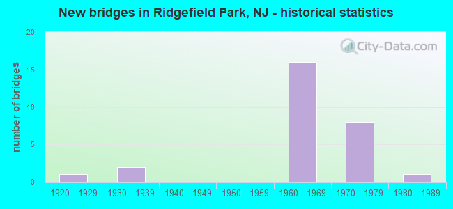
- New bridges - historical statistics
- 11920-1929
- 21930-1939
- 161960-1969
- 81970-1979
- 11980-1989

- Reconstructed bridges - Historical Statistics
- 11980-1989
- 01990-1999
- 12000-2009


- Bridge Condition - Deck
- 54.5%Good
- 27.3%Satisfactory
- 18.2%Fair

- Bridge Condition - Superstructure
- 27.3%Good
- 63.6%Satisfactory
- 9.1%Fair

- Bridge Condition - Substructure
- 81.8%Satisfactory
- 18.2%Fair
Find on map >> Show street view
Structure Number: 20050A, Location: 0.12 Mile E. of I-95 NJTP (Lat: 40.853339, Lng: -74.011650), Route carried "on" structure: City street , Year Built: 1985, Status: Open, Structure Length: 1.43m (4.69ft), Average Daily Traffic: 604 (year 2020), Truck Traffic: 1%, Average Future Daily Traffic: 725 (year 2040), Design Load: HS 20+Mod, Features Intersected: TEANECK CREEK, Facility Carried by Structure: CHALLENGER ROAD
Minimum Vertical Clearance: 30+ m (98+ ft), Kilometerpoint: 0.000, Lanes on structure: 2, Owner: County Highway Agency, Approaching Roadway Width: 14.0m (45.9ft), Material/Design: Concrete, Design/Construction: Culvert, Number Of Spans In Main Unit: 2, Length of Maximum Span: 7.0m (23.0ft), Curb or Sidewalk Widths: Left: 0.0m, Right: 1.4m (4.6ft)
Condition: Channel: Good, Culverts: Good, Operating Rating: 85.3 metric tons, Method Used To Determine Operating Rating: Load Factor (LF), Inventory Rating: 50.8 metric tons, Method Used To Determine Inventory Rating: Load Factor (LF), Structural Evaluation: Better than present minimum criteria, Waterway Adequacy: Superior to present desirable criteria, Approach Roadway Alignment: Equal to present desirable criteria, Designated Inspection Frequency: Every 24 months, Inspection Date: April 2020
Find on map >> Show street view
Structure Number: 221156, Location: 0.3 MILES WEST OF RT I-95 (Lat: 40.848450, Lng: -74.021889), Route carried "on" structure: US 46, Year Built: 1934, Status: Open, Structure Length: 1.40m (4.59ft), Average Daily Traffic: 42,587 (year 2021), Truck Traffic: 4%, Average Future Daily Traffic: 51,104 (year 2041), Design Load: H 20, Features Intersected: CR 39 (TEANECK ROAD)
Minimum Vertical Clearance: 30+ m (98+ ft), Kilometerpoint: 113.748, Lanes on structure: 4, Lanes under structure: 2, Base Highway Network: Yes, Owner: State Highway Agency, Approaching Roadway Width: 15.2m (49.9ft), Skew: 1 degrees, Material/Design: Steel, Design/Construction: Stringer/Multi-beam, Number Of Spans In Main Unit: 1, Length of Maximum Span: 13.7m (44.9ft), Curb or Sidewalk Widths: Left: 2.0m (6.6ft), Right: 2.0m (6.6ft), Curb-To-Curb Width: 15.2m (49.9ft), Out-to-Out Width: 19.8m (65.0ft)
Condition: Deck: Fair, Superstructure: Satisfactory, Substructure: Fair, Operating Rating: 62.6 metric tons, Method Used To Determine Operating Rating: Load Factor (LF), Inventory Rating: 37.2 metric tons, Method Used To Determine Inventory Rating: Load Factor (LF), Structural Evaluation: Somewhat better than minimum adequacy, Deck Geometry: High priority of corrective action, Underclear: High priority of corrective action, Approach Roadway Alignment: Better than present minimum criteria, Length Of Structure Improvement: 1.40m (4.59ft), Designated Inspection Frequency: Every 24 months, Inspection Date: March 2021, Roadway Improvement Cost: $111,000, Total Project Cost: $137,000 ( Estimate for 2021), Deck Structure Type: Concrete Cast-file-Place, Wearing Surface/Protective System: Wearing Surface: Bituminous, Membrane: Other
Find on map >> Show street view
Structure Number: 22215, Location: 0.2MI E OF I95&US46 JCT (Lat: 40.844389, Lng: -74.012061), Route carried "on" structure: US 46, Year Built: 1928, Year Reconstructed: 2006, Status: Open, Structure Length: 15.73m (51.61ft), Average Daily Traffic: 43,554 (year 2021), Truck Traffic: 4%, Average Future Daily Traffic: 53,144 (year 2041), Design Load: HS 20+Mod, Features Intersected: OVERPECK CREEK
Minimum Vertical Clearance: 30+ m (98+ ft), Kilometerpoint: 114.762, Lanes on structure: 7, Base Highway Network: Yes, Owner: State Highway Agency, Approaching Roadway Width: 26.5m (86.9ft), Skew: 30 degrees, Navigation Control: Yes ( Vertical Clearance: 4.9m (16.1ft), Horizontal Clearance: 21.3m (69.9ft)), Material/Design: Steel, Design/Construction: Stringer/Multi-beam, Number Of Spans In Main Unit: 6, Length of Maximum Span: 28.7m (94.2ft), Curb or Sidewalk Widths: Left: 1.8m (5.9ft), Right: 2.0m (6.6ft), Curb-To-Curb Width: 26.5m (86.9ft), Out-to-Out Width: 33.2m (108.9ft)
Condition: Deck: Satisfactory, Superstructure: Fair, Substructure: Satisfactory, Channel: Good, Operating Rating: 76.2 metric tons, Method Used To Determine Operating Rating: Load Factor (LF), Inventory Rating: 45.4 metric tons, Method Used To Determine Inventory Rating: Load Factor (LF), Structural Evaluation: Somewhat better than minimum adequacy, Deck Geometry: Meets minimum limits, Waterway Adequacy: Superior to present desirable criteria, Approach Roadway Alignment: Equal to present desirable criteria, Designated Inspection Frequency: Every 24 months, Underwater Inspection Frequency: Every 48 months, Inspection Date: March 2021, Underwater Inspection Date: May 2021, Deck Structure Type: Concrete Cast-file-Place, Wearing Surface/Protective System: Wearing Surface: Monolithic Concrete, Deck Protection: Epoxy Coated Reinforcing
Find on map >> Show street view
Structure Number: 226165, Location: 0.8MI W.OF I-80/I-95 JCT. (Lat: 40.866769, Lng: -74.029739), Route carried "on" structure: City street , Year Built: 1963, Status: Open, Structure Length: 6.86m (22.51ft), Average Daily Traffic: 11,742 (year 2020), Truck Traffic: 3%, Average Future Daily Traffic: 14,091 (year 2040), Design Load: HS 20, Features Intersected: ROUTE I-80, Facility Carried by Structure: SECOND ST
Minimum Vertical Clearance: 30+ m (98+ ft), Kilometerpoint: 0.338, Lanes on structure: 2, Lanes under structure: 10, Owner: State Highway Agency, Approaching Roadway Width: 11.6m (38.1ft), Skew: 1 degrees, Material/Design: Steel, Design/Construction: Stringer/Multi-beam, Number Of Spans In Main Unit: 3, Length of Maximum Span: 28.3m (92.8ft), Curb or Sidewalk Widths: Left: 1.8m (5.9ft), Right: 1.8m (5.9ft), Curb-To-Curb Width: 11.6m (38.1ft), Out-to-Out Width: 15.8m (51.8ft)
Condition: Deck: Good, Superstructure: Good, Substructure: Fair, Operating Rating: 50.8 metric tons, Method Used To Determine Operating Rating: Load Factor (LF), Inventory Rating: 34.5 metric tons, Method Used To Determine Inventory Rating: Load Factor (LF), Structural Evaluation: Somewhat better than minimum adequacy, Deck Geometry: Somewhat better than minimum adequacy, Underclear: Meets minimum limits, Approach Roadway Alignment: Equal to present desirable criteria, Designated Inspection Frequency: Every 24 months, Inspection Date: October 2020, Deck Structure Type: Concrete Cast-file-Place, Wearing Surface/Protective System: Wearing Surface: Monolithic Concrete
Find on map >> Show street view
Structure Number: 22916, Location: 1.2 MI SOUTH OF I-80 JCT (Lat: 40.847961, Lng: -74.019400), Route carried "on" structure: Ramp Interstate 95, Year Built: 1973, Status: Open, Structure Length: 8.99m (29.49ft), Average Daily Traffic: 9,260 (year 2020), Truck Traffic: 9%, Average Future Daily Traffic: 11,100 (year 2040), Design Load: HS 20+Mod, Features Intersected: US 46
Minimum Vertical Clearance: 30+ m (98+ ft), Kilometerpoint: 116.388, Lanes on structure: 1, Lanes under structure: 4, Owner: State Highway Agency, Approaching Roadway Width: 7.3m (24.0ft), Skew: 9 degrees, Material/Design: Steel continuous, Design/Construction: Stringer/Multi-beam, Number Of Spans In Main Unit: 4, Length of Maximum Span: 27.1m (88.9ft), Curb or Sidewalk Widths: Left: 0.8m (2.6ft), Right: 0.5m (1.6ft), Curb-To-Curb Width: 7.3m (24.0ft), Out-to-Out Width: 9.2m (30.2ft)
Condition: Deck: Fair, Superstructure: Satisfactory, Substructure: Satisfactory, Operating Rating: 59.0 metric tons, Method Used To Determine Operating Rating: Load Factor (LF), Inventory Rating: 35.4 metric tons, Method Used To Determine Inventory Rating: Load Factor (LF), Structural Evaluation: Equal to present minimum criteria, Deck Geometry: Better than present minimum criteria, Underclear: Equal to present minimum criteria, Approach Roadway Alignment: Equal to present minimum criteria, Designated Inspection Frequency: Every 24 months, Inspection Date: July 2020, Deck Structure Type: Concrete Cast-file-Place, Wearing Surface/Protective System: Wearing Surface: Monolithic Concrete
Find on map >> Show street view
Structure Number: M11727, Location: 1.6 NI N HACKENSACK RIVER (Lat: 40.840989, Lng: -74.018669), Route carried "on" structure: County highway 124, Year Built: 1968, Status: Open, Structure Length: 10.06m (33.01ft), Average Daily Traffic: 17,170 (year 2021), Truck Traffic: 15%, Average Future Daily Traffic: 20,950 (year 2041), Design Load: HS 20, Features Intersected: NJTPK SN80&95, NS80&95, Facility Carried by Structure: BERGEN TURNPIKE
Minimum Vertical Clearance: 30+ m (98+ ft), Kilometerpoint: 1.448, Lanes on structure: 2, Lanes under structure: 12, Owner: State Toll Authority, Approaching Roadway Width: 10.1m (33.1ft), Skew: 1 degrees, Material/Design: Steel, Design/Construction: Stringer/Multi-beam, Number Of Spans In Main Unit: 4, Length of Maximum Span: 27.7m (90.9ft), Curb or Sidewalk Widths: Left: 0.6m (2.0ft), Right: 1.8m (5.9ft), Curb-To-Curb Width: 10.1m (33.1ft), Out-to-Out Width: 13.1m (43.0ft)
Condition: Deck: Good, Superstructure: Satisfactory, Substructure: Satisfactory, Operating Rating: 51.5 metric tons, Method Used To Determine Operating Rating: Load and Resistance Factor Rating (LRFR) rating reported by rating factor(RF) method using HL-93 loadings, Inventory Rating: 39.9 metric tons, Method Used To Determine Inventory Rating: Load and Resistance Factor Rating (LRFR) rating reported by rating factor(RF) method using HL-93 loadings, Structural Evaluation: Equal to present minimum criteria, Deck Geometry: Meets minimum limits, Underclear: Meets minimum limits, Approach Roadway Alignment: Equal to present minimum criteria, Designated Inspection Frequency: Every 24 months, Inspection Date: April 2021, Deck Structure Type: Concrete Cast-file-Place, Wearing Surface/Protective System: Wearing Surface: Bituminous, Membrane: Other
Find on map >> Show street view
Structure Number: M11763C, Location: 1.9 MI N HACKENSACK RIVER (Lat: 40.846544, Lng: -74.018914), Route carried "on" structure: Ramp Interstate 95, Year Built: 1970, Status: Open, Structure Length: 3.38m (11.09ft), Average Daily Traffic: 9,573 (year 2021), Truck Traffic: 15%, Average Future Daily Traffic: 11,680 (year 2041), Design Load: HS 20, Features Intersected: RAMP L, Facility Carried by Structure: NJ TPK RAMP WT
Minimum Vertical Clearance: 30+ m (98+ ft), Kilometerpoint: 116.388, Lanes on structure: 1, Lanes under structure: 1, Owner: State Toll Authority, Approaching Roadway Width: 7.3m (24.0ft), Skew: 3 degrees, Material/Design: Steel, Design/Construction: Stringer/Multi-beam, Number Of Spans In Main Unit: 1, Length of Maximum Span: 32.9m (107.9ft), Curb or Sidewalk Widths: Left: 0.6m (2.0ft), Right: 0.6m (2.0ft), Curb-To-Curb Width: 7.3m (24.0ft), Out-to-Out Width: 9.1m (29.9ft)
Condition: Deck: Good, Superstructure: Good, Substructure: Satisfactory, Operating Rating: 74.5 metric tons, Method Used To Determine Operating Rating: Load and Resistance Factor Rating (LRFR) rating reported by rating factor(RF) method using HL-93 loadings, Inventory Rating: 57.7 metric tons, Method Used To Determine Inventory Rating: Load and Resistance Factor Rating (LRFR) rating reported by rating factor(RF) method using HL-93 loadings, Structural Evaluation: Equal to present minimum criteria, Deck Geometry: Better than present minimum criteria, Underclear: Meets minimum limits, Approach Roadway Alignment: Equal to present desirable criteria, Designated Inspection Frequency: Every 24 months, Inspection Date: April 2021, Deck Structure Type: Concrete Cast-file-Place, Wearing Surface/Protective System: Wearing Surface: Bituminous, Membrane: Other
Find on map >> Show street view
Structure Number: M11767I, Location: 1.9 MI N HACKENSACK RIVER (Lat: 40.846494, Lng: -74.017483), Route carried "on" structure: Interstate 95, Year Built: 1968, Status: Open, Structure Length: 7.25m (23.79ft), Average Daily Traffic: 84,423 (year 2021), Truck Traffic: 15%, Average Future Daily Traffic: 102,996 (year 2041), Design Load: HS 20, Features Intersected: US RT 46 & RAMPS L & ET, Facility Carried by Structure: NJ TPK SN-80
Minimum Vertical Clearance: 30+ m (98+ ft), Kilometerpoint: 116.388, Lanes on structure: 2, Lanes under structure: 7, Base Highway Network: Yes, Owner: State Toll Authority, Approaching Roadway Width: 14.3m (46.9ft), Skew: 1 degrees, Material/Design: Steel continuous, Design/Construction: Stringer/Multi-beam, Number Of Spans In Main Unit: 2, Length of Maximum Span: 36.0m (118.1ft), Curb or Sidewalk Widths: Left: 0.0m, Right: 0.6m (2.0ft), Curb-To-Curb Width: 14.5m (47.6ft), Out-to-Out Width: 15.8m (51.8ft)
Condition: Deck: Good, Superstructure: Satisfactory, Substructure: Satisfactory, Operating Rating: 32.7 metric tons, Method Used To Determine Operating Rating: Load and Resistance Factor Rating (LRFR) rating reported by rating factor(RF) method using HL-93 loadings, Inventory Rating: 25.3 metric tons, Method Used To Determine Inventory Rating: Load and Resistance Factor Rating (LRFR) rating reported by rating factor(RF) method using HL-93 loadings, Structural Evaluation: Equal to present minimum criteria, Deck Geometry: Superior to present desirable criteria, Underclear: Somewhat better than minimum adequacy, Approach Roadway Alignment: Equal to present desirable criteria, Designated Inspection Frequency: Every 24 months, Inspection Date: April 2021, Deck Structure Type: Concrete Cast-file-Place, Wearing Surface/Protective System: Wearing Surface: Bituminous, Membrane: Other
Find on map >> Show street view
Structure Number: M11767N, Location: 1.9 MI N HACKENSACK RIVER (Lat: 40.846356, Lng: -74.017086), Route carried "on" structure: Interstate 95, Year Built: 1968, Status: Open, Structure Length: 9.75m (31.99ft), Average Daily Traffic: 82,768 (year 2021), Truck Traffic: 15%, Average Future Daily Traffic: 100,978 (year 2041), Design Load: HS 20, Features Intersected: US 46&RAMPS L,N,ET,& E
Minimum Vertical Clearance: 30+ m (98+ ft), Kilometerpoint: 116.388, Lanes on structure: 3, Lanes under structure: 8, Base Highway Network: Yes, Owner: State Toll Authority, Approaching Roadway Width: 16.2m (53.1ft), Skew: 9 degrees, Material/Design: Steel, Design/Construction: Stringer/Multi-beam, Number Of Spans In Main Unit: 3, Length of Maximum Span: 34.7m (113.8ft), Curb or Sidewalk Widths: Left: 0.6m (2.0ft), Right: 0.6m (2.0ft), Curb-To-Curb Width: 16.2m (53.1ft), Out-to-Out Width: 18.0m (59.1ft)
Condition: Deck: Satisfactory, Superstructure: Satisfactory, Substructure: Satisfactory, Operating Rating: 48.6 metric tons, Method Used To Determine Operating Rating: Load and Resistance Factor Rating (LRFR) rating reported by rating factor(RF) method using HL-93 loadings, Inventory Rating: 37.3 metric tons, Method Used To Determine Inventory Rating: Load and Resistance Factor Rating (LRFR) rating reported by rating factor(RF) method using HL-93 loadings, Structural Evaluation: Equal to present minimum criteria, Deck Geometry: Equal to present minimum criteria, Underclear: Equal to present minimum criteria, Approach Roadway Alignment: Equal to present desirable criteria, Designated Inspection Frequency: Every 24 months, Inspection Date: April 2021, Deck Structure Type: Concrete Cast-file-Place, Wearing Surface/Protective System: Wearing Surface: Bituminous, Membrane: Other
Find on map >> Show street view
Structure Number: M11767O, Location: 1.9 MI N HACKENSACK RIVER (Lat: 40.846578, Lng: -74.017947), Route carried "on" structure: Interstate 95, Year Built: 1968, Status: Open, Structure Length: 7.77m (25.49ft), Average Daily Traffic: 82,768 (year 2021), Truck Traffic: 10%, Average Future Daily Traffic: 100,978 (year 2041), Design Load: H 20, Features Intersected: US RT 46, RAMPS L, N, ET, Facility Carried by Structure: NJTPK NS80
Minimum Vertical Clearance: 30+ m (98+ ft), Kilometerpoint: 116.388, Lanes on structure: 3, Lanes under structure: 8, Base Highway Network: Yes, Owner: State Toll Authority, Approaching Roadway Width: 18.0m (59.1ft), Skew: 1 degrees, Material/Design: Steel continuous, Design/Construction: Stringer/Multi-beam, Number Of Spans In Main Unit: 2, Length of Maximum Span: 40.5m (132.9ft), Curb or Sidewalk Widths: Left: 0.6m (2.0ft), Right: 0.0m, Curb-To-Curb Width: 18.0m (59.1ft), Out-to-Out Width: 19.5m (64.0ft)
Condition: Deck: Good, Superstructure: Satisfactory, Substructure: Satisfactory, Operating Rating: 27.9 metric tons, Method Used To Determine Operating Rating: Load and Resistance Factor Rating (LRFR) rating reported by rating factor(RF) method using HL-93 loadings, Inventory Rating: 21.7 metric tons, Method Used To Determine Inventory Rating: Load and Resistance Factor Rating (LRFR) rating reported by rating factor(RF) method using HL-93 loadings, Structural Evaluation: Somewhat better than minimum adequacy, Deck Geometry: Better than present minimum criteria, Underclear: Meets minimum limits, Approach Roadway Alignment: Equal to present desirable criteria, Designated Inspection Frequency: Every 24 months, Inspection Date: April 2021, Deck Structure Type: Concrete Cast-file-Place, Wearing Surface/Protective System: Wearing Surface: Bituminous, Membrane: Other
Find on map >> Show street view
Structure Number: M11767S, Location: 1.9 MI N HACKENSACK RIVER (Lat: 40.846556, Lng: -74.017697), Route carried "on" structure: Interstate 95, Year Built: 1968, Status: Open, Structure Length: 7.25m (23.79ft), Average Daily Traffic: 82,777 (year 2021), Truck Traffic: 10%, Average Future Daily Traffic: 100,987 (year 2041), Design Load: H 20, Features Intersected: US RT 46&RAMPS L, ET & N
Minimum Vertical Clearance: 30+ m (98+ ft), Kilometerpoint: 116.388, Lanes on structure: 3, Lanes under structure: 7, Base Highway Network: Yes, Owner: State Toll Authority, Approaching Roadway Width: 20.4m (66.9ft), Skew: 1 degrees, Material/Design: Steel continuous, Design/Construction: Stringer/Multi-beam, Number Of Spans In Main Unit: 2, Length of Maximum Span: 36.0m (118.1ft), Curb-To-Curb Width: 20.4m (66.9ft), Out-to-Out Width: 21.0m (68.9ft)
Condition: Deck: Good, Superstructure: Satisfactory, Substructure: Satisfactory, Operating Rating: 31.4 metric tons, Method Used To Determine Operating Rating: Load and Resistance Factor Rating (LRFR) rating reported by rating factor(RF) method using HL-93 loadings, Inventory Rating: 24.3 metric tons, Method Used To Determine Inventory Rating: Load and Resistance Factor Rating (LRFR) rating reported by rating factor(RF) method using HL-93 loadings, Structural Evaluation: Equal to present minimum criteria, Deck Geometry: Superior to present desirable criteria, Underclear: Equal to present minimum criteria, Approach Roadway Alignment: Equal to present desirable criteria, Designated Inspection Frequency: Every 24 months, Inspection Date: April 2021, Deck Structure Type: Concrete Cast-file-Place, Wearing Surface/Protective System: Wearing Surface: Bituminous, Membrane: Other
Find on map >> Show street view
Structure Number: M11783, Location: 1 MI SOUTH OF I-80 JCT (Lat: 40.849181, Lng: -74.017436), Route carried "on" structure: City street , Year Built: 1972, Year Reconstructed: 1993, Status: Open, Structure Length: 13.96m (45.80ft), Average Daily Traffic: 5,420 (year 2021), Truck Traffic: 2%, Average Future Daily Traffic: 6,610 (year 2041), Design Load: HS 20+Mod, Features Intersected: NJTP & I-80, Facility Carried by Structure: EMERSON STREET
Minimum Vertical Clearance: 30+ m (98+ ft), Kilometerpoint: 0.290, Lanes on structure: 2, Lanes under structure: 14, Owner: State Toll Authority, Approaching Roadway Width: 9.1m (29.9ft), Material/Design: Steel, Design/Construction: Stringer/Multi-beam, Number Of Spans In Main Unit: 5, Length of Maximum Span: 43.0m (141.1ft), Curb or Sidewalk Widths: Left: 1.8m (5.9ft), Right: 1.8m (5.9ft), Curb-To-Curb Width: 9.1m (29.9ft), Out-to-Out Width: 13.4m (44.0ft)
Condition: Deck: Satisfactory, Superstructure: Good, Substructure: Satisfactory, Operating Rating: 44.7 metric tons, Method Used To Determine Operating Rating: Load and Resistance Factor Rating (LRFR) rating reported by rating factor(RF) method using HL-93 loadings, Inventory Rating: 34.7 metric tons, Method Used To Determine Inventory Rating: Load and Resistance Factor Rating (LRFR) rating reported by rating factor(RF) method using HL-93 loadings, Structural Evaluation: Equal to present minimum criteria, Deck Geometry: Meets minimum limits, Underclear: Meets minimum limits, Approach Roadway Alignment: Equal to present desirable criteria, Designated Inspection Frequency: Every 24 months, Inspection Date: April 2021, Deck Structure Type: Concrete Cast-file-Place, Wearing Surface/Protective System: Wearing Surface: Bituminous, Membrane: Preformed Fabric, Deck Protection: Epoxy Coated Reinforcing
Find on map >> Show street view
Structure Number: 221156, Location: 0.3 MILES WEST OF RT I-95 (Lat: 40.848450, Lng: -74.021889), Route carried "under" structure: County highway 39, Year Built: 1934, Structure Length: 0. m, Average Daily Traffic: 7,034 (year 2021), Truck Traffic: 4%, Features Intersected: CR 39 (TEANECK ROAD), Facility Carried by Structure: ROUTE US 46
Minimum Vertical Clearance: 4.29m (14.07ft), Kilometerpoint: 0.644, Lanes on structure: 4, Lanes under structure: 2, Material/Design: Steel, Design/Construction: Stringer/Multi-beam, Length of Maximum Span: 13.7m (44.9ft)
Find on map >> Show street view
Structure Number: 226165, Location: 0.8MI W.OF I-80/I-95 JCT. (Lat: 40.866769, Lng: -74.029739), Route carried "under" structure: Interstate 80, Year Built: 1963, Structure Length: 0. m, Average Daily Traffic: 114,607 (year 2020), Truck Traffic: 2%, Features Intersected: ROUTE I-80, Facility Carried by Structure: SECOND ST
Minimum Vertical Clearance: 5.46m (17.91ft), Kilometerpoint: 108.180, Lanes on structure: 2, Lanes under structure: 10, Material/Design: Steel, Design/Construction: Stringer/Multi-beam, Length of Maximum Span: 28.3m (92.8ft)
Find on map >> Show street view
Structure Number: 22916, Location: 1.2 MI SOUTH OF I-80 JCT (Lat: 40.847961, Lng: -74.019400), Route carried "under" structure: US 46, Year Built: 1973, Structure Length: 0. m, Average Daily Traffic: 42,200 (year 2020), Truck Traffic: 4%, Features Intersected: US 46, Facility Carried by Structure: I-95 RAMP "N"
Minimum Vertical Clearance: 5.21m (17.09ft), Kilometerpoint: 114.022, Lanes on structure: 1, Lanes under structure: 4, Material/Design: Steel continuous, Design/Construction: Stringer/Multi-beam, Length of Maximum Span: 27.1m (88.9ft)
Find on map >> Show street view
Structure Number: M11727, Location: 1.6 NI N HACKENSACK RIVER (Lat: 40.840989, Lng: -74.018669), Route carried "under" structure: Interstate 95, Year Built: 1968, Structure Length: 0. m, Average Daily Traffic: 324,767 (year 2021), Truck Traffic: 7%, Features Intersected: NJTPK SN80&95, NS80&95, Facility Carried by Structure: BERGEN TURNPIKE
Minimum Vertical Clearance: 5.56m (18.24ft), Kilometerpoint: 115.760, Lanes on structure: 2, Lanes under structure: 12, Material/Design: Steel, Design/Construction: Stringer/Multi-beam, Length of Maximum Span: 27.7m (90.9ft)
Find on map >> Show street view
Structure Number: M11763C, Location: 1.9 MI N HACKENSACK RIVER (Lat: 40.846544, Lng: -74.018914), Route carried "under" structure: Ramp Interstate 46, Year Built: 1970, Structure Length: 0. m, Average Daily Traffic: 7,767 (year 2021), Truck Traffic: 1%, Features Intersected: RAMP L, Facility Carried by Structure: NJ TPK RAMP WT
Minimum Vertical Clearance: 4.80m (15.75ft), Kilometerpoint: 114.022, Lanes on structure: 1, Lanes under structure: 1, Material/Design: Steel, Design/Construction: Stringer/Multi-beam, Length of Maximum Span: 32.9m (107.9ft)
Find on map >> Show street view
Structure Number: M11767I, Location: 1.9 MI N HACKENSACK RIVER (Lat: 40.846494, Lng: -74.017483), Route carried "under" structure: Ramp Interstate 95, Year Built: 1968, Structure Length: 0. m, Average Daily Traffic: 1,090 (year 2021), Truck Traffic: 12%, Features Intersected: US RT 46 & RAMPS L & ET, Facility Carried by Structure: NJ TPK SN-80
Minimum Vertical Clearance: 4.93m (16.17ft), Kilometerpoint: 116.388, Lanes on structure: 2, Lanes under structure: 1, Toll: On toll road, Material/Design: Steel continuous, Design/Construction: Stringer/Multi-beam, Length of Maximum Span: 36.0m (118.1ft)
Find on map >> Show street view
Structure Number: M11767I, Location: 1.9 MI N HACKENSACK RIVER (Lat: 40.846494, Lng: -74.017483), Route carried "under" structure: US 46, Year Built: 1968, Structure Length: 0. m, Average Daily Traffic: 46,055 (year 2021), Truck Traffic: 14%, Features Intersected: US RT 46 & RAMPS L & ET, Facility Carried by Structure: NJ TPK SN-80
Minimum Vertical Clearance: 5.18m (16.99ft), Kilometerpoint: 114.280, Lanes on structure: 2, Lanes under structure: 6, Material/Design: Steel continuous, Design/Construction: Stringer/Multi-beam, Length of Maximum Span: 36.0m (118.1ft)
Find on map >> Show street view
Structure Number: M11767N, Location: 1.9 MI N HACKENSACK RIVER (Lat: 40.846356, Lng: -74.017086), Route carried "under" structure: US 46, Year Built: 1968, Structure Length: 0. m, Average Daily Traffic: 46,055 (year 2021), Features Intersected: US 46&RAMPS L,N,ET,& E, Facility Carried by Structure: NJ TPK SN-95
Minimum Vertical Clearance: 5.31m (17.42ft), Kilometerpoint: 114.280, Lanes on structure: 3, Lanes under structure: 6, Material/Design: Steel, Design/Construction: Stringer/Multi-beam, Length of Maximum Span: 34.7m (113.8ft)
Find on map >> Show street view
Structure Number: M11767N, Location: 1.9 MI N HACKENSACK RIVER (Lat: 40.846356, Lng: -74.017086), Route carried "under" structure: Ramp Interstate 95, Year Built: 1968, Structure Length: 0. m, Average Daily Traffic: 2,181 (year 2021), Truck Traffic: 12%, Features Intersected: US 46&RAMPS L,N,ET,& E
Minimum Vertical Clearance: 5.11m (16.77ft), Kilometerpoint: 116.388, Lanes on structure: 3, Lanes under structure: 2, Material/Design: Steel, Design/Construction: Stringer/Multi-beam, Length of Maximum Span: 34.7m (113.8ft)
Find on map >> Show street view
Structure Number: M11767O, Location: 1.9 MI N HACKENSACK RIVER (Lat: 40.846578, Lng: -74.017947), Route carried "under" structure: Ramp Interstate 95, Year Built: 1968, Structure Length: 0. m, Average Daily Traffic: 1,090 (year 2021), Truck Traffic: 12%, Features Intersected: US RT 46, RAMPS L, N, ET, Facility Carried by Structure: NJTPK NS80
Minimum Vertical Clearance: 5.08m (16.67ft), Kilometerpoint: 116.388, Lanes on structure: 3, Lanes under structure: 1, Material/Design: Steel continuous, Design/Construction: Stringer/Multi-beam, Length of Maximum Span: 40.5m (132.9ft)
Find on map >> Show street view
Structure Number: M11767O, Location: 1.9 MI N HACKENSACK RIVER (Lat: 40.846578, Lng: -74.017947), Route carried "under" structure: US 46, Year Built: 1968, Structure Length: 0. m, Average Daily Traffic: 46,055 (year 2021), Truck Traffic: 5%, Features Intersected: US RT 46, RAMPS L, N, ET, Facility Carried by Structure: NJTPK NS80
Minimum Vertical Clearance: 5.46m (17.91ft), Kilometerpoint: 114.280, Lanes on structure: 3, Lanes under structure: 7, Material/Design: Steel continuous, Design/Construction: Stringer/Multi-beam, Length of Maximum Span: 40.5m (132.9ft)
Find on map >> Show street view
Structure Number: M11767S, Location: 1.9 MI N HACKENSACK RIVER (Lat: 40.846556, Lng: -74.017697), Route carried "under" structure: US 46, Year Built: 1968, Structure Length: 0. m, Average Daily Traffic: 46,055 (year 2021), Truck Traffic: 5%, Features Intersected: US RT 46&RAMPS L, ET & N, Facility Carried by Structure: NJTPK NS 95
Minimum Vertical Clearance: 5.33m (17.49ft), Kilometerpoint: 114.280, Lanes on structure: 3, Lanes under structure: 6, Toll: On toll road, Material/Design: Steel continuous, Design/Construction: Stringer/Multi-beam, Length of Maximum Span: 36.0m (118.1ft)
Find on map >> Show street view
Structure Number: M11767S, Location: 1.9 MI N HACKENSACK RIVER (Lat: 40.846556, Lng: -74.017697), Route carried "under" structure: Ramp Interstate 95, Year Built: 1968, Structure Length: 0. m, Average Daily Traffic: 1,090 (year 2021), Truck Traffic: 12%, Features Intersected: US RT 46&RAMPS L, ET & N
Minimum Vertical Clearance: 5.05m (16.57ft), Kilometerpoint: 116.388, Lanes on structure: 3, Lanes under structure: 1, Material/Design: Steel continuous, Design/Construction: Stringer/Multi-beam, Length of Maximum Span: 36.0m (118.1ft)
Find on map >> Show street view
Structure Number: M11783, Location: 1 MI SOUTH OF I-80 JCT (Lat: 40.849181, Lng: -74.017436), Route carried "under" structure: Ramp US 46, Year Built: 1972, Structure Length: 0. m, Average Daily Traffic: 40,265 (year 2021), Truck Traffic: 4%, Features Intersected: NJTP & I-80, Facility Carried by Structure: EMERSON STREET
Minimum Vertical Clearance: 5.36m (17.59ft), Kilometerpoint: 116.645, Lanes on structure: 2, Lanes under structure: 2, Material/Design: Steel, Design/Construction: Stringer/Multi-beam, Length of Maximum Span: 43.0m (141.1ft)
Find on map >> Show street view
Structure Number: M11783, Location: 1 MI SOUTH OF I-80 JCT (Lat: 40.849181, Lng: -74.017436), Route carried "under" structure: Ramp City street , Year Built: 1972, Structure Length: 0. m, Average Daily Traffic: 1,217 (year 2021), Truck Traffic: 1%, Features Intersected: NJTP & I-80, Facility Carried by Structure: EMERSON STREET
Minimum Vertical Clearance: 5.33m (17.49ft), Kilometerpoint: 0.000, Lanes on structure: 2, Lanes under structure: 1, Material/Design: Steel, Design/Construction: Stringer/Multi-beam, Length of Maximum Span: 43.0m (141.1ft)
Find on map >> Show street view
Structure Number: M11783, Location: 1 MI SOUTH OF I-80 JCT (Lat: 40.849181, Lng: -74.017436), Route carried "under" structure: Interstate 95, Year Built: 1972, Structure Length: 0. m, Average Daily Traffic: 79,878 (year 2021), Truck Traffic: 10%, Features Intersected: NJTP & I-80, Facility Carried by Structure: EMERSON STREET
Minimum Vertical Clearance: 6.04m (19.82ft), Kilometerpoint: 116.645, Lanes on structure: 2, Lanes under structure: 11, Material/Design: Steel, Design/Construction: Stringer/Multi-beam, Length of Maximum Span: 43.0m (141.1ft)