Bridge Statistics for Reisterstown, Maryland (MD)
Condition, Traffic, Stress, Structural Evaluation, Project Costs
- National Bridge Inventory (NBI) Statistics
- 30Number of bridges
- 299ft / 91.2mTotal length
- $1,396,000Total costs
- 405,079Total average daily traffic
- 14,538Total average daily truck traffic
- National Bridge Inventory (NBI) Registered Bridges for Reisterstown
- No street view available for this location
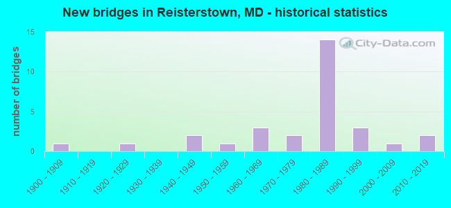
- New bridges - historical statistics
- 11900-1909
- 11920-1929
- 21940-1949
- 11950-1959
- 31960-1969
- 21970-1979
- 141980-1989
- 31990-1999
- 12000-2009
- 22010-2019

- Reconstructed bridges - Historical Statistics
- 21980-1989
- 11990-1999
- 02000-2009
- 12010-2019


- Bridge Condition - Deck
- 60.0%Good
- 13.3%Satisfactory
- 20.0%Fair
- 6.7%Serious

- Bridge Condition - Superstructure
- 6.7%Very good
- 33.3%Good
- 53.3%Satisfactory
- 6.7%Fair

- Bridge Condition - Substructure
- 53.3%Good
- 33.3%Satisfactory
- 6.7%Fair
- 6.7%Poor

- Bridge Condition - Channel
- 6.7%Very good
- 40.0%Good
- 40.0%Satisfactory
- 13.3%Fair

- Bridge Condition - Culverts
- 50.0%Good
- 50.0%Satisfactory
Find on map >> Show street view
Structure Number: 10000003008301, Location: ON CARROLL CO LINE (Lat: 39.489056, Lng: -76.869144), Route carried "on" structure: State highway 140, Year Built: 1946, Year Reconstructed: 2016, Status: Open, Structure Length: 6.32m (20.73ft), Average Daily Traffic: 53,100 (year 2010), Truck Traffic: 8%, Average Future Daily Traffic: 79,000 (year 2030), Features Intersected: N BRANCH OF PATAPSCO RIV
Minimum Vertical Clearance: 30+ m (98+ ft), Kilometerpoint: 20.064, Lanes on structure: 4, Base Highway Network: Yes, Owner: State Highway Agency, Approaching Roadway Width: 19.5m (64.0ft), Material/Design: Steel continuous, Design/Construction: Stringer/Multi-beam, Number Of Spans In Main Unit: 3, Length of Maximum Span: 24.1m (79.1ft), Curb or Sidewalk Widths: Left: 0.9m (3.0ft), Right: 0.9m (3.0ft), Curb-To-Curb Width: 21.3m (69.9ft), Out-to-Out Width: 22.3m (73.2ft)
Condition: Deck: Good, Superstructure: Very good, Substructure: Good, Channel: Good, Operating Rating: 58.0 metric tons, Method Used To Determine Operating Rating: Load and Resistance Factor Rating (LRFR) rating reported by rating factor(RF) method using HL-93 loadings, Inventory Rating: 44.7 metric tons, Method Used To Determine Inventory Rating: Load and Resistance Factor Rating (LRFR) rating reported by rating factor(RF) method using HL-93 loadings, Structural Evaluation: Better than present minimum criteria, Deck Geometry: Superior to present desirable criteria, Waterway Adequacy: Equal to present desirable criteria, Approach Roadway Alignment: Equal to present desirable criteria, Designated Inspection Frequency: Every 24 months, Underwater Inspection Frequency: Every 48 months, Inspection Date: April 2021, Underwater Inspection Date: August 2019, Deck Structure Type: Concrete Cast-file-Place, Wearing Surface/Protective System: Wearing Surface: Monolithic Concrete, Deck Protection: Epoxy Coated Reinforcing
Find on map >> Show street view
Structure Number: 10000003033501, Location: 0.43 MI W OF MD 140 (Lat: 39.451578, Lng: -76.830378), Route carried "on" structure: County highway 503, Year Built: 1985, Status: Open, Structure Length: 6.77m (22.21ft), Average Daily Traffic: 3,054 (year 2009), Truck Traffic: 5%, Average Future Daily Traffic: 3,623 (year 2025), Design Load: HS 20, Features Intersected: IS 795, Facility Carried by Structure: BERRYMANS LANE
Minimum Vertical Clearance: 30+ m (98+ ft), Kilometerpoint: 0.708, Lanes on structure: 2, Lanes under structure: 4, Owner: State Highway Agency, Approaching Roadway Width: 13.4m (44.0ft), Material/Design: Steel continuous, Design/Construction: Stringer/Multi-beam, Number Of Spans In Main Unit: 2, Length of Maximum Span: 33.8m (110.9ft), Curb-To-Curb Width: 12.2m (40.0ft), Out-to-Out Width: 13.4m (44.0ft)
Condition: Deck: Good, Superstructure: Satisfactory, Substructure: Good, Operating Rating: 82.1 metric tons, Method Used To Determine Operating Rating: Load Factor (LF), Inventory Rating: 49.4 metric tons, Method Used To Determine Inventory Rating: Load Factor (LF), Structural Evaluation: Equal to present minimum criteria, Deck Geometry: Equal to present minimum criteria, Underclear: Somewhat better than minimum adequacy, Approach Roadway Alignment: Equal to present desirable criteria, Designated Inspection Frequency: Every 24 months, Inspection Date: Febuary 2021, Deck Structure Type: Concrete Cast-file-Place, Wearing Surface/Protective System: Wearing Surface: Monolithic Concrete, Deck Protection: Epoxy Coated Reinforcing
Find on map >> Show street view
Structure Number: 10000003033601, Location: 0.39 MI W OF MD 140 (Lat: 39.458708, Lng: -76.834831), Route carried "on" structure: County highway 504, Year Built: 1985, Status: Open, Structure Length: 7.10m (23.29ft), Average Daily Traffic: 299 (year 1994), Truck Traffic: 5%, Average Future Daily Traffic: 362 (year 2012), Design Load: HS 20, Features Intersected: IS 795, Facility Carried by Structure: STOCKSDALE AVENUE
Minimum Vertical Clearance: 30+ m (98+ ft), Kilometerpoint: 0.965, Lanes on structure: 2, Lanes under structure: 4, Owner: State Highway Agency, Approaching Roadway Width: 13.4m (44.0ft), Skew: 1 degrees, Material/Design: Steel continuous, Design/Construction: Stringer/Multi-beam, Number Of Spans In Main Unit: 2, Length of Maximum Span: 35.7m (117.1ft), Curb-To-Curb Width: 12.2m (40.0ft), Out-to-Out Width: 13.4m (44.0ft)
Condition: Deck: Good, Superstructure: Good, Substructure: Good, Operating Rating: 76.2 metric tons, Method Used To Determine Operating Rating: Load Factor (LF), Inventory Rating: 45.4 metric tons, Method Used To Determine Inventory Rating: Load Factor (LF), Structural Evaluation: Better than present minimum criteria, Deck Geometry: Superior to present desirable criteria, Underclear: Somewhat better than minimum adequacy, Approach Roadway Alignment: Equal to present desirable criteria, Designated Inspection Frequency: Every 24 months, Inspection Date: March 2021, Deck Structure Type: Concrete Cast-file-Place, Wearing Surface/Protective System: Wearing Surface: Monolithic Concrete, Deck Protection: Epoxy Coated Reinforcing
Find on map >> Show street view
Structure Number: 10000003033801, Location: @ MD 140 (Lat: 39.471486, Lng: -76.837133), Route carried "on" structure: Interstate 795, Year Built: 1985, Status: Open, Structure Length: 3.93m (12.89ft), Average Daily Traffic: 55,810 (year 2009), Truck Traffic: 8%, Average Future Daily Traffic: 80,570 (year 2029), Design Load: HS 20, Features Intersected: IS 795 RAMP '1'
Minimum Vertical Clearance: 30+ m (98+ ft), Kilometerpoint: 14.288, Lanes on structure: 4, Lanes under structure: 2, Base Highway Network: Yes, Owner: State Highway Agency, Approaching Roadway Width: 20.7m (67.9ft), Skew: 4 degrees, Material/Design: Steel, Design/Construction: Stringer/Multi-beam, Number Of Spans In Main Unit: 1, Length of Maximum Span: 37.8m (124.0ft), Curb-To-Curb Width: 16.2m (53.1ft), Out-to-Out Width: 17.4m (57.1ft)
Condition: Deck: Good, Superstructure: Satisfactory, Substructure: Good, Operating Rating: 77.5 metric tons, Method Used To Determine Operating Rating: Load Factor (LF), Inventory Rating: 46.3 metric tons, Method Used To Determine Inventory Rating: Load Factor (LF), Structural Evaluation: Equal to present minimum criteria, Deck Geometry: High priority of replacement, Underclear: Equal to present desirable criteria, Approach Roadway Alignment: Equal to present desirable criteria, Length Of Structure Improvement: 3.93m (12.89ft), Designated Inspection Frequency: Every 24 months, Inspection Date: March 2021, Bridge Improvement Cost: $442,000, Roadway Improvement Cost: $44,000, Total Project Cost: $486,000, Deck Structure Type: Concrete Cast-file-Place, Wearing Surface/Protective System: Wearing Surface: Monolithic Concrete, Deck Protection: Epoxy Coated Reinforcing
Find on map >> Show street view
Structure Number: 10000003033901, Location: 0.17 MILE NORTH OF MD 795 (Lat: 39.473972, Lng: -76.839011), Route carried "on" structure: State highway 140, Year Built: 1985, Status: Open, Structure Length: 8.29m (27.20ft), Average Daily Traffic: 18,840 (year 2009), Truck Traffic: 8%, Average Future Daily Traffic: 33,062 (year 2026), Design Load: HS 20, Features Intersected: IS 795 RAMPS '1' & '6'
Minimum Vertical Clearance: 30+ m (98+ ft), Kilometerpoint: 16.975, Lanes on structure: 2, Lanes under structure: 4, Base Highway Network: Yes, Owner: State Highway Agency, Approaching Roadway Width: 11.6m (38.1ft), Skew: 4 degrees, Material/Design: Steel continuous, Design/Construction: Stringer/Multi-beam, Number Of Spans In Main Unit: 2, Length of Maximum Span: 40.2m (131.9ft), Curb-To-Curb Width: 11.6m (38.1ft), Out-to-Out Width: 12.8m (42.0ft)
Condition: Deck: Good, Superstructure: Good, Substructure: Good, Inventory Rating: 59.4 metric tons, Method Used To Determine Inventory Rating: Load Factor (LF), Structural Evaluation: Better than present minimum criteria, Deck Geometry: Better than present minimum criteria, Underclear: Equal to present minimum criteria, Approach Roadway Alignment: Equal to present desirable criteria, Designated Inspection Frequency: Every 24 months, Inspection Date: March 2021, Deck Structure Type: Concrete Cast-file-Place, Wearing Surface/Protective System: Wearing Surface: Monolithic Concrete, Deck Protection: Epoxy Coated Reinforcing
Find on map >> Show street view
Structure Number: 10000006002001, Location: .04 MILE NORTH OF MD 879D (Lat: 39.499842, Lng: -76.882686), Route carried "on" structure: State highway 91, Year Built: 1965, Status: Open, Structure Length: 5.33m (17.49ft), Average Daily Traffic: 5,640 (year 2009), Truck Traffic: 8%, Average Future Daily Traffic: 8,460 (year 2029), Design Load: HS 20, Features Intersected: NORTH BRANCH PATAPSCO RI
Minimum Vertical Clearance: 30+ m (98+ ft), Kilometerpoint: 6.082, Lanes on structure: 2, Owner: State Highway Agency, Approaching Roadway Width: 13.4m (44.0ft), Skew: 1 degrees, Material/Design: Steel, Design/Construction: Stringer/Multi-beam, Number Of Spans In Main Unit: 3, Length of Maximum Span: 17.7m (58.1ft), Curb-To-Curb Width: 9.1m (29.9ft), Out-to-Out Width: 10.7m (35.1ft)
Condition: Deck: Fair, Superstructure: Satisfactory, Substructure: Satisfactory, Channel: Good, Inventory Rating: 57.6 metric tons, Method Used To Determine Inventory Rating: Load Factor (LF), Structural Evaluation: Equal to present minimum criteria, Deck Geometry: High priority of corrective action, Waterway Adequacy: Superior to present desirable criteria, Approach Roadway Alignment: Equal to present desirable criteria, Designated Inspection Frequency: Every 24 months, Inspection Date: January 2021, Deck Structure Type: Concrete Cast-file-Place, Wearing Surface/Protective System: Wearing Surface: Bituminous, Membrane: Other
Find on map >> Show street view
Structure Number: 10000006004701, Location: .14 MILE SOUTH OF MD 879E (Lat: 39.500414, Lng: -76.881406), Route carried "on" structure: State highway 91, Year Built: 1965, Status: Open, Structure Length: 4.18m (13.71ft), Average Daily Traffic: 5,640 (year 2009), Truck Traffic: 8%, Average Future Daily Traffic: 6,964 (year 2026), Design Load: HS 20, Features Intersected: MARYLAND MIDLAND RR
Minimum Vertical Clearance: 30+ m (98+ ft), Kilometerpoint: 6.211, Lanes on structure: 2, Owner: State Highway Agency, Approaching Roadway Width: 13.4m (44.0ft), Material/Design: Steel, Design/Construction: Stringer/Multi-beam, Number Of Spans In Main Unit: 3, Length of Maximum Span: 14.9m (48.9ft), Curb-To-Curb Width: 9.1m (29.9ft), Out-to-Out Width: 10.7m (35.1ft)
Condition: Deck: Fair, Superstructure: Satisfactory, Substructure: Satisfactory, Inventory Rating: 60.3 metric tons, Method Used To Determine Inventory Rating: Load Factor (LF), Structural Evaluation: Equal to present minimum criteria, Deck Geometry: High priority of corrective action, Underclear: Somewhat better than minimum adequacy, Approach Roadway Alignment: Equal to present desirable criteria, Designated Inspection Frequency: Every 24 months, Inspection Date: January 2021, Deck Structure Type: Concrete Cast-file-Place, Wearing Surface/Protective System: Wearing Surface: Bituminous, Membrane: Other
Find on map >> Show street view
Structure Number: 200000B-014001, Location: 0.1 MI SE OF OLD HANOVER (Lat: 39.518072, Lng: -76.819864), Route carried "on" structure: County highway 180, Year Built: 1907, Year Reconstructed: 2001, Status: Posted for load, Structure Length: 1.40m (4.59ft), Average Daily Traffic: 540 (year 2021), Truck Traffic: 5%, Average Future Daily Traffic: 660 (year 2041), Features Intersected: CSX RAILROAD, Facility Carried by Structure: PINEY GROVE ROAD
Minimum Vertical Clearance: 30+ m (98+ ft), Kilometerpoint: 0.177, Lanes on structure: 1, Owner: County Highway Agency, Approaching Roadway Width: 4.0m (13.1ft), Material/Design: Wood or Timber, Design/Construction: Stringer/Multi-beam, Number Of Spans In Main Unit: 3, Length of Maximum Span: 5.2m (17.1ft), Curb-To-Curb Width: 4.8m (15.7ft), Out-to-Out Width: 5.5m (18.0ft)
Condition: Deck: Fair, Superstructure: Satisfactory, Substructure: Poor, Operating Rating: 18.6 metric tons, Method Used To Determine Operating Rating: Allowable Stress (AS), Inventory Rating: 14.1 metric tons, Method Used To Determine Inventory Rating: Allowable Stress (AS), Structural Evaluation: Meets minimum limits, Deck Geometry: High priority of corrective action, Underclear: High priority of replacement, Approach Roadway Alignment: Equal to present minimum criteria, Bridge Posting: Required (Relationship of Operating Rating to Maximum Legal Load: > 39.9% below), Length Of Structure Improvement: 1.40m (4.59ft), Designated Inspection Frequency: Every 12 months, Inspection Date: January 2021, Bridge Improvement Cost: $155,000, Roadway Improvement Cost: $5,000, Total Project Cost: $160,000, Deck Structure Type: Wood or Timber, Wearing Surface/Protective System: Wearing Surface: Wood or Timber
Find on map >> Show street view
Structure Number: 200000B-015201, Location: ON CARROLL COUNTY LINE (Lat: 39.493706, Lng: -76.868108), Route carried "on" structure: County highway 473, Year Built: 2008, Status: Open, Structure Length: 1.55m (5.09ft), Average Daily Traffic: 214 (year 2022), Truck Traffic: 5%, Average Future Daily Traffic: 261 (year 2042), Design Load: HS 20, Features Intersected: TRIBUTARY OF PATAPSCO RI, Facility Carried by Structure: GLEN FALLS RD
Minimum Vertical Clearance: 30+ m (98+ ft), Kilometerpoint: 3.588, Lanes on structure: 2, Owner: County Highway Agency, Approaching Roadway Width: 6.1m (20.0ft), Material/Design: Steel, Design/Construction: Truss - Thru, Number Of Spans In Main Unit: 1, Length of Maximum Span: 15.2m (49.9ft), Curb-To-Curb Width: 7.3m (24.0ft), Out-to-Out Width: 9.3m (30.5ft)
Condition: Deck: Satisfactory, Superstructure: Satisfactory, Substructure: Satisfactory, Channel: Satisfactory, Operating Rating: 68.9 metric tons, Method Used To Determine Operating Rating: Load Factor (LF), Inventory Rating: 41.3 metric tons, Method Used To Determine Inventory Rating: Load Factor (LF), Structural Evaluation: Equal to present minimum criteria, Deck Geometry: Somewhat better than minimum adequacy, Waterway Adequacy: Better than present minimum criteria, Approach Roadway Alignment: Equal to present desirable criteria, Designated Inspection Frequency: Every 24 months, Critical Feature Inspection Frequency: Every 24 months, Inspection Date: January 2022, Critical Feature Inspection Date: January 2022, Deck Structure Type: Steel plate, Wearing Surface/Protective System: Wearing Surface: Other
Find on map >> Show street view
Structure Number: 200000B-015301, Location: 1.28 MILES NW OF MD 30 (Lat: 39.523772, Lng: -76.850233), Route carried "on" structure: County highway 187, Year Built: 1975, Status: Posted for load, Structure Length: 1.74m (5.71ft), Average Daily Traffic: 300 (year 2016), Truck Traffic: 5%, Average Future Daily Traffic: 455 (year 2037), Design Load: HS 20, Features Intersected: GLEN FALLS, Facility Carried by Structure: MOUNT GILEAD RD
Minimum Vertical Clearance: 30+ m (98+ ft), Kilometerpoint: 2.060, Lanes on structure: 2, Owner: County Highway Agency, Approaching Roadway Width: 5.2m (17.1ft), Material/Design: Steel, Design/Construction: Truss - Thru, Number Of Spans In Main Unit: 1, Length of Maximum Span: 15.5m (50.9ft), Curb-To-Curb Width: 7.2m (23.6ft), Out-to-Out Width: 7.6m (24.9ft)
Condition: Deck: Serious, Superstructure: Satisfactory, Substructure: Good, Channel: Good, Operating Rating: 27.7 metric tons, Method Used To Determine Operating Rating: Load Factor (LF), Inventory Rating: 16.3 metric tons, Method Used To Determine Inventory Rating: Load Factor (LF), Structural Evaluation: Somewhat better than minimum adequacy, Deck Geometry: Meets minimum limits, Waterway Adequacy: Better than present minimum criteria, Approach Roadway Alignment: Equal to present minimum criteria, Bridge Posting: Required (Relationship of Operating Rating to Maximum Legal Load: 10.0 - 19.9% below), Designated Inspection Frequency: Every 24 months, Critical Feature Inspection Frequency: Every 24 months, Other Special Inspection Frequency: Every 12 months, Inspection Date: May 2021, Critical Feature Inspection Date: May 2021, Other Special Inspection Date: May 2021, Deck Structure Type: Steel plate, Wearing Surface/Protective System: Wearing Surface: Other
Find on map >> Show street view
Structure Number: 200000B-016301, Location: 0.74 MI N OF MD 128 (Lat: 39.495439, Lng: -76.795128), Route carried "on" structure: County highway 445, Year Built: 1920, Year Reconstructed: 1988, Status: Open, Structure Length: 0.82m (2.69ft), Average Daily Traffic: 306 (year 2021), Truck Traffic: 5%, Average Future Daily Traffic: 404 (year 2041), Features Intersected: SLADE RUN, Facility Carried by Structure: LONGNECKER ROAD
Minimum Vertical Clearance: 30+ m (98+ ft), Kilometerpoint: 1.191, Lanes on structure: 2, Owner: County Highway Agency, Approaching Roadway Width: 4.9m (16.1ft), Skew: 1 degrees, Material/Design: Prestressed concrete, Design/Construction: Box Beam or Girders - Multiple, Number Of Spans In Main Unit: 1, Length of Maximum Span: 7.6m (24.9ft), Curb or Sidewalk Widths: Left: 0.3m (1.0ft), Right: 0.3m (1.0ft), Curb-To-Curb Width: 6.2m (20.3ft), Out-to-Out Width: 6.8m (22.3ft)
Condition: Deck: Satisfactory, Superstructure: Satisfactory, Substructure: Satisfactory, Channel: Satisfactory, Inventory Rating: 70.7 metric tons, Method Used To Determine Inventory Rating: Load Factor (LF), Structural Evaluation: Equal to present minimum criteria, Deck Geometry: Meets minimum limits, Waterway Adequacy: Equal to present minimum criteria, Approach Roadway Alignment: Equal to present desirable criteria, Designated Inspection Frequency: Every 24 months, Inspection Date: September 2021, Deck Structure Type: Concrete Cast-file-Place, Wearing Surface/Protective System: Wearing Surface: Integral Concrete
Find on map >> Show street view
Structure Number: 200000B-017201, Location: 1.04 MILES E OF MD 140 (Lat: 39.443100, Lng: -76.783500), Route carried "on" structure: County highway 587, Year Built: 1992, Status: Open, Structure Length: 1.25m (4.10ft), Average Daily Traffic: 9,800 (year 2019), Truck Traffic: 5%, Average Future Daily Traffic: 14,700 (year 2039), Features Intersected: GWYNNS FALLS, Facility Carried by Structure: GWYNNBROOK AVENUE
Minimum Vertical Clearance: 30+ m (98+ ft), Kilometerpoint: 1.673, Lanes on structure: 2, Owner: County Highway Agency, Approaching Roadway Width: 9.1m (29.9ft), Skew: 3 degrees, Material/Design: Concrete, Design/Construction: Culvert, Length of Maximum Span: 3.4m (11.2ft), Curb-To-Curb Width: 9.1m (29.9ft), Out-to-Out Width: 9.8m (32.2ft)
Condition: Channel: Satisfactory, Culverts: Good, Inventory Rating: 61.2 metric tons, Method Used To Determine Inventory Rating: Load Factor (LF), Structural Evaluation: Better than present minimum criteria, Deck Geometry: High priority of corrective action, Waterway Adequacy: Better than present minimum criteria, Approach Roadway Alignment: Equal to present minimum criteria, Designated Inspection Frequency: Every 24 months, Inspection Date: April 2021, Deck Structure Type: Concrete Cast-file-Place, Wearing Surface/Protective System: Wearing Surface: Bituminous
Find on map >> Show street view
Structure Number: 200000B-017801, Location: 0.59 MI S OF MD 128 (Lat: 39.494194, Lng: -76.777194), Route carried "on" structure: County highway 442, Year Built: 1940, Status: Posted for load, Structure Length: 1.62m (5.31ft), Average Daily Traffic: 900 (year 2013), Truck Traffic: 5%, Average Future Daily Traffic: 1,970 (year 2040), Features Intersected: DELAWARE RUN, Facility Carried by Structure: BELMONT AVENUE
Minimum Vertical Clearance: 30+ m (98+ ft), Kilometerpoint: 0.949, Lanes on structure: 2, Owner: County Highway Agency, Approaching Roadway Width: 6.1m (20.0ft), Skew: 4 degrees, Material/Design: Steel, Design/Construction: Stringer/Multi-beam, Number Of Spans In Main Unit: 2, Length of Maximum Span: 7.3m (24.0ft), Curb-To-Curb Width: 6.2m (20.3ft), Out-to-Out Width: 6.8m (22.3ft)
Condition: Deck: Good, Superstructure: Fair, Substructure: Fair, Channel: Fair, Operating Rating: 68.0 metric tons, Method Used To Determine Operating Rating: Load Factor (LF), Inventory Rating: 40.8 metric tons, Method Used To Determine Inventory Rating: Load Factor (LF), Structural Evaluation: Somewhat better than minimum adequacy, Deck Geometry: High priority of corrective action, Waterway Adequacy: Equal to present minimum criteria, Approach Roadway Alignment: Equal to present minimum criteria, Length Of Structure Improvement: 1.83m (6.00ft), Designated Inspection Frequency: Every 24 months, Inspection Date: June 2021, Bridge Improvement Cost: $740,000, Roadway Improvement Cost: $10,000, Total Project Cost: $750,000, Deck Structure Type: Concrete Cast-file-Place, Wearing Surface/Protective System: Wearing Surface: Bituminous
Find on map >> Show street view
Structure Number: 200000B-029903, Location: 0.24 MI SE OF MD 140 (Lat: 39.444497, Lng: -76.817197), Route carried "on" structure: County highway 6781, Year Built: 1974, Year Reconstructed: 1986, Status: Open, Structure Length: 1.07m (3.51ft), Average Daily Traffic: 20,695 (year 2014), Truck Traffic: 5%, Average Future Daily Traffic: 24,000 (year 2034), Features Intersected: ROACHES RUN, Facility Carried by Structure: FRANKLIN BOULEVARD
Minimum Vertical Clearance: 30+ m (98+ ft), Kilometerpoint: 1.496, Lanes on structure: 4, Base Highway Network: Yes, Owner: County Highway Agency, Approaching Roadway Width: 16.8m (55.1ft), Skew: 1 degrees, Material/Design: Steel, Design/Construction: Culvert, Length of Maximum Span: 3.0m (9.8ft), Curb or Sidewalk Widths: Left: 1.2m (3.9ft), Right: 1.2m (3.9ft)
Condition: Channel: Good, Culverts: Good, Structural Evaluation: Better than present minimum criteria, Waterway Adequacy: Better than present minimum criteria, Approach Roadway Alignment: Equal to present desirable criteria, Designated Inspection Frequency: Every 24 months, Inspection Date: April 2021
Find on map >> Show street view
Structure Number: 200000B-037202, Location: HAMMERSHIRE RD 0.11 (Lat: 39.443600, Lng: -76.806797), Route carried "on" structure: County highway 602, Year Built: 1984, Status: Open, Structure Length: 1.59m (5.22ft), Average Daily Traffic: 5,500 (year 2009), Truck Traffic: 5%, Average Future Daily Traffic: 6,000 (year 2029), Design Load: HS 20, Features Intersected: ROACHES RUN, Facility Carried by Structure: HAMMERSHIRE ROAD
Minimum Vertical Clearance: 30+ m (98+ ft), Kilometerpoint: 0.177, Lanes on structure: 2, Owner: County Highway Agency, Approaching Roadway Width: 12.2m (40.0ft), Skew: 6 degrees, Material/Design: Concrete, Design/Construction: Culvert, Length of Maximum Span: 4.9m (16.1ft), Curb-To-Curb Width: 12.2m (40.0ft), Out-to-Out Width: 18.3m (60.0ft)
Condition: Channel: Good, Culverts: Satisfactory, Operating Rating: 86.2 metric tons, Method Used To Determine Operating Rating: Load Factor (LF), Inventory Rating: 51.7 metric tons, Method Used To Determine Inventory Rating: Load Factor (LF), Structural Evaluation: Equal to present minimum criteria, Deck Geometry: Somewhat better than minimum adequacy, Waterway Adequacy: Better than present minimum criteria, Approach Roadway Alignment: Equal to present desirable criteria, Designated Inspection Frequency: Every 24 months, Inspection Date: April 2021, Deck Structure Type: Concrete Cast-file-Place, Wearing Surface/Protective System: Wearing Surface: Bituminous, Deck Protection: Epoxy Coated Reinforcing
Find on map >> Show street view
Structure Number: 200000B-039303, Location: 0.41 MI N OF MD 140 (Lat: 39.443100, Lng: -76.801697), Route carried "on" structure: County highway 611, Year Built: 1967, Status: Open, Structure Length: 0.91m (2.99ft), Average Daily Traffic: 9,000 (year 2017), Truck Traffic: 5%, Average Future Daily Traffic: 12,250 (year 2037), Design Load: H 20, Features Intersected: BRANCH OF GWYNNS FALLS, Facility Carried by Structure: HIGH FALCON ROAD
Minimum Vertical Clearance: 30+ m (98+ ft), Kilometerpoint: 0.965, Lanes on structure: 2, Owner: County Highway Agency, Approaching Roadway Width: 11.6m (38.1ft), Material/Design: Steel, Design/Construction: Culvert, Length of Maximum Span: 4.0m (13.1ft), Curb or Sidewalk Widths: Left: 1.2m (3.9ft), Right: 1.2m (3.9ft)
Condition: Channel: Fair, Culverts: Satisfactory, Structural Evaluation: Equal to present minimum criteria, Waterway Adequacy: Equal to present desirable criteria, Approach Roadway Alignment: Equal to present desirable criteria, Designated Inspection Frequency: Every 24 months, Inspection Date: April 2021
Find on map >> Show street view
Structure Number: 200000B-047201, Location: 0.6 MI SOUTH OF I-795 (Lat: 39.436806, Lng: -76.823750), Route carried "on" structure: County highway 6779, Year Built: 1997, Status: Open, Structure Length: 1.92m (6.30ft), Average Daily Traffic: 10,305 (year 2022), Truck Traffic: 5%, Average Future Daily Traffic: 12,578 (year 2042), Design Load: HS 25 or greater, Features Intersected: RED RUN, Facility Carried by Structure: RED RUN BOULEVARD
Minimum Vertical Clearance: 30+ m (98+ ft), Kilometerpoint: 0.225, Lanes on structure: 5, Owner: County Highway Agency, Approaching Roadway Width: 17.1m (56.1ft), Skew: 2 degrees, Material/Design: Steel, Design/Construction: Stringer/Multi-beam, Number Of Spans In Main Unit: 1, Length of Maximum Span: 17.7m (58.1ft), Curb or Sidewalk Widths: Left: 1.8m (5.9ft), Right: 1.8m (5.9ft), Curb-To-Curb Width: 17.0m (55.8ft), Out-to-Out Width: 21.3m (69.9ft)
Condition: Deck: Good, Superstructure: Good, Substructure: Satisfactory, Channel: Satisfactory, Inventory Rating: 77.5 metric tons, Method Used To Determine Inventory Rating: Load Factor (LF), Structural Evaluation: Equal to present minimum criteria, Deck Geometry: High priority of replacement, Waterway Adequacy: Better than present minimum criteria, Approach Roadway Alignment: Equal to present desirable criteria, Designated Inspection Frequency: Every 24 months, Inspection Date: January 2022, Deck Structure Type: Concrete Cast-file-Place, Wearing Surface/Protective System: Wearing Surface: Integral Concrete, Deck Protection: Epoxy Coated Reinforcing
Find on map >> Show street view
Structure Number: 200000B-048503, Location: 1.0 MI. E OF MD 140 (Lat: 39.458756, Lng: -76.806408), Route carried "on" structure: County highway , Year Built: 1996, Status: Open, Structure Length: 2.13m (6.99ft), Average Daily Traffic: 1,442 (year 2019), Truck Traffic: 5%, Average Future Daily Traffic: 2,143 (year 2039), Design Load: HS 20, Features Intersected: TRIBUTARY TO GWYNNS FALL, Facility Carried by Structure: GWYNNWEST ROAD
Minimum Vertical Clearance: 30+ m (98+ ft), Kilometerpoint: 0.000, Lanes on structure: 2, Owner: County Highway Agency, Approaching Roadway Width: 12.8m (42.0ft), Skew: 3 degrees, Material/Design: Steel, Design/Construction: Culvert, Length of Maximum Span: 2.7m (8.9ft), Curb or Sidewalk Widths: Left: 1.2m (3.9ft), Right: 1.2m (3.9ft)
Condition: Channel: Satisfactory, Culverts: Satisfactory, Structural Evaluation: Equal to present minimum criteria, Waterway Adequacy: Better than present minimum criteria, Approach Roadway Alignment: Better than present minimum criteria, Designated Inspection Frequency: Every 24 months, Inspection Date: October 2021
Find on map >> Show street view
Structure Number: 200000B-056301, Location: 1.1 MI E. OF MD 140 (Lat: 39.454583, Lng: -76.799044), Route carried "on" structure: County highway , Year Built: 2011, Status: Open, Structure Length: 15.64m (51.31ft), Average Daily Traffic: 8,084 (year 2022), Truck Traffic: 2%, Average Future Daily Traffic: 15,507 (year 2042), Design Load: HS 25 or greater, Features Intersected: CSX, GWYNN'S FALLS, Facility Carried by Structure: CHERRY HILL ROAD
Minimum Vertical Clearance: 30+ m (98+ ft), Kilometerpoint: 0.000, Lanes on structure: 2, Owner: County Highway Agency, Approaching Roadway Width: 9.1m (29.9ft), Material/Design: Steel continuous, Design/Construction: Stringer/Multi-beam, Number Of Spans In Main Unit: 3, Length of Maximum Span: 63.1m (207.0ft), Curb or Sidewalk Widths: Left: 1.7m (5.6ft), Right: 1.7m (5.6ft), Curb-To-Curb Width: 9.1m (29.9ft), Out-to-Out Width: 13.2m (43.3ft)
Condition: Deck: Good, Superstructure: Good, Substructure: Good, Channel: Very good, Operating Rating: 85.7 metric tons, Method Used To Determine Operating Rating: Load Factor (LF), Inventory Rating: 51.7 metric tons, Method Used To Determine Inventory Rating: Load Factor (LF), Structural Evaluation: Better than present minimum criteria, Deck Geometry: Meets minimum limits, Underclear: Equal to present desirable criteria, Waterway Adequacy: Superior to present desirable criteria, Approach Roadway Alignment: Equal to present desirable criteria, Designated Inspection Frequency: Every 24 months, Inspection Date: January 2022, Deck Structure Type: Concrete Cast-file-Place, Wearing Surface/Protective System: Wearing Surface: Integral Concrete, Deck Protection: Epoxy Coated Reinforcing
Find on map >> Show street view
Structure Number: 200000B-060203, Location: 1.0 MI W OF I-795 (Lat: 39.425194, Lng: -76.831833), Route carried "on" structure: County highway 6239, Year Built: 1950, Status: Open, Structure Length: 0.82m (2.69ft), Average Daily Traffic: 1,000 (year 2014), Truck Traffic: 1%, Average Future Daily Traffic: 1,240 (year 2036), Features Intersected: TRIBUTARY TO RED RUN, Facility Carried by Structure: SUNNYMEADOW LANE
Minimum Vertical Clearance: 30+ m (98+ ft), Kilometerpoint: 0.000, Lanes on structure: 2, Owner: County Highway Agency, Approaching Roadway Width: 7.0m (23.0ft), Skew: 4 degrees, Material/Design: Steel, Design/Construction: Culvert, Number Of Spans In Main Unit: 2, Length of Maximum Span: 3.4m (11.2ft)
Condition: Channel: Satisfactory, Culverts: Good, Structural Evaluation: Better than present minimum criteria, Waterway Adequacy: Better than present minimum criteria, Approach Roadway Alignment: Equal to present minimum criteria, Designated Inspection Frequency: Every 24 months, Inspection Date: April 2021
Find on map >> Show street view
Structure Number: 200000BC651301, Location: 0.4 MI W IVY MILL RD (Lat: 39.448878, Lng: -76.877822), Route carried "on" structure: City street 515, Year Built: 2011, Status: Open, Structure Length: 16.83m (55.22ft), Average Daily Traffic: 2,645 (year 2003), Truck Traffic: 5%, Average Future Daily Traffic: 3,300 (year 2025), Design Load: HS 25 or greater, Features Intersected: LIBERTY RESERVOIR, Facility Carried by Structure: NICODEMUS ROAD
Minimum Vertical Clearance: 30+ m (98+ ft), Kilometerpoint: 6.436, Lanes on structure: 2, Owner: City or Municipal Highway Agency, Approaching Roadway Width: 7.9m (25.9ft), Material/Design: Prestressed concrete, Design/Construction: Stringer/Multi-beam, Number Of Spans In Main Unit: 5, Length of Maximum Span: 33.2m (108.9ft), Curb or Sidewalk Widths: Left: 0.0m, Right: 1.7m (5.6ft), Curb-To-Curb Width: 9.4m (30.8ft), Out-to-Out Width: 12.5m (41.0ft)
Condition: Deck: Good, Superstructure: Good, Substructure: Good, Channel: Good, Operating Rating: 69.4 metric tons, Method Used To Determine Operating Rating: Load Factor (LF), Inventory Rating: 41.7 metric tons, Method Used To Determine Inventory Rating: Load Factor (LF), Structural Evaluation: Better than present minimum criteria, Deck Geometry: Meets minimum limits, Waterway Adequacy: Superior to present desirable criteria, Approach Roadway Alignment: Equal to present desirable criteria, Designated Inspection Frequency: Every 24 months, Underwater Inspection Frequency: Every 60 months, Inspection Date: March 2020, Underwater Inspection Date: November 2018, Deck Structure Type: Concrete Cast-file-Place, Wearing Surface/Protective System: Wearing Surface: Monolithic Concrete, Deck Protection: Epoxy Coated Reinforcing
Find on map >> Show street view
Structure Number: 100000030333012, Location: 0.06 M E OF RED RUN BLVD (Lat: 39.434650, Lng: -76.816289), Route carried "under" structure: County highway 8101, Year Built: 1985, Structure Length: 0. m, Average Daily Traffic: 1,600 (year 2005), Features Intersected: CHURCH ROAD, Facility Carried by Structure: IS 795 SBR
Minimum Vertical Clearance: 6.10m (20.01ft), Kilometerpoint: 0.097, Lanes on structure: 2, Lanes under structure: 2, Material/Design: Steel continuous, Design/Construction: Stringer/Multi-beam, Length of Maximum Span: 23.5m (77.1ft)
Find on map >> Show street view
Structure Number: 100000030334011, Location: 1.39 MI N OF MD 940B (Lat: 39.440769, Lng: -76.822500), Route carried "under" structure: County highway 6781, Year Built: 1985, Structure Length: 0. m, Average Daily Traffic: 6,724 (year 2008), Features Intersected: FRANKLIN BOULEVARD, Facility Carried by Structure: IS 795 NBR
Minimum Vertical Clearance: 4.57m (14.99ft), Kilometerpoint: 0.901, Lanes on structure: 3, Lanes under structure: 4, Material/Design: Steel continuous, Design/Construction: Stringer/Multi-beam, Length of Maximum Span: 27.4m (89.9ft)
Find on map >> Show street view
Structure Number: 100000030334012, Location: 1.39 MI N OF MD 940B (Lat: 39.440950, Lng: -76.823044), Route carried "under" structure: State highway 6781, Year Built: 1985, Structure Length: 0. m, Average Daily Traffic: 6,724 (year 2008), Features Intersected: FRANKLIN BOULEVARD, Facility Carried by Structure: IS 795 SBR
Minimum Vertical Clearance: 4.57m (14.99ft), Kilometerpoint: 0.869, Lanes on structure: 3, Lanes under structure: 4, Material/Design: Steel continuous, Design/Construction: Stringer/Multi-beam, Length of Maximum Span: 27.4m (89.9ft)
Find on map >> Show street view
Structure Number: 10000003033501, Location: 1.59 MILE SOUTH OF MD 140 (Lat: 39.451578, Lng: -76.830378), Route carried "under" structure: Interstate 795, Year Built: 1985, Structure Length: 0. m, Average Daily Traffic: 55,810 (year 2009), Features Intersected: IS 795, Facility Carried by Structure: BERRYMANS LANE
Minimum Vertical Clearance: 30+ m (98+ ft), Kilometerpoint: 11.907, Lanes on structure: 2, Lanes under structure: 4, Material/Design: Steel continuous, Design/Construction: Stringer/Multi-beam, Length of Maximum Span: 33.8m (110.9ft)
Find on map >> Show street view
Structure Number: 10000003033601, Location: 1.04 MILE SOUTH OF MD 140 (Lat: 39.458708, Lng: -76.834831), Route carried "under" structure: Interstate 795, Year Built: 1985, Structure Length: 0. m, Average Daily Traffic: 55,810 (year 2009), Features Intersected: IS 795, Facility Carried by Structure: STOCKSDALE AVENUE
Minimum Vertical Clearance: 4.88m (16.01ft), Kilometerpoint: 12.792, Lanes on structure: 2, Lanes under structure: 4, Material/Design: Steel continuous, Design/Construction: Stringer/Multi-beam, Length of Maximum Span: 35.7m (117.1ft)
Find on map >> Show street view
Structure Number: 100000030337011, Location: 0.64 MI S OF MD 140 (Lat: 39.463758, Lng: -76.837386), Route carried "under" structure: County highway 499, Year Built: 1985, Structure Length: 0. m, Average Daily Traffic: 2,099 (year 2007), Features Intersected: COCKEYS MILL ROAD, Facility Carried by Structure: IS 795 NBR
Minimum Vertical Clearance: 4.57m (14.99ft), Kilometerpoint: 0.724, Lanes on structure: 3, Lanes under structure: 2, Material/Design: Steel continuous, Design/Construction: Stringer/Multi-beam, Length of Maximum Span: 20.1m (65.9ft)
Find on map >> Show street view
Structure Number: 100000030337012, Location: 0.64 MI S OF MD 140 (Lat: 39.464161, Lng: -76.837778), Route carried "under" structure: County highway 499, Year Built: 1985, Structure Length: 0. m, Average Daily Traffic: 2,099 (year 2007), Features Intersected: COCKEYS MILL ROAD, Facility Carried by Structure: IS 795 SBR
Minimum Vertical Clearance: 4.57m (14.99ft), Kilometerpoint: 0.837, Lanes on structure: 3, Lanes under structure: 2, Material/Design: Steel continuous, Design/Construction: Stringer/Multi-beam, Length of Maximum Span: 20.1m (65.9ft)
Find on map >> Show street view
Structure Number: 10000003033801, Location: @ MD 140 (Lat: 39.471486, Lng: -76.837133), Route carried "under" structure: Ramp Interstate 795, Year Built: 1985, Structure Length: 0. m, Average Daily Traffic: 20,468 (year 2007), Features Intersected: IS 795 RAMP '1'
Minimum Vertical Clearance: 5.18m (16.99ft), Kilometerpoint: 0.467, Lanes on structure: 4, Lanes under structure: 2, Material/Design: Steel, Design/Construction: Stringer/Multi-beam, Length of Maximum Span: 37.8m (124.0ft)
Find on map >> Show street view
Structure Number: 10000003033901, Location: 0.64 MI N OF MD 940Q (Lat: 39.473972, Lng: -76.839011), Route carried "under" structure: Interstate 795, Year Built: 1985, Structure Length: 0. m, Average Daily Traffic: 40,631 (year 2007), Features Intersected: IS 795 RAMPS '1' & '6', Facility Carried by Structure: MD 140 SBR
Minimum Vertical Clearance: 5.18m (16.99ft), Kilometerpoint: 14.433, Lanes on structure: 2, Lanes under structure: 4, Material/Design: Steel continuous, Design/Construction: Stringer/Multi-beam, Length of Maximum Span: 40.2m (131.9ft)