Bridge Statistics for Redwood City, California (CA)
Condition, Traffic, Stress, Structural Evaluation, Project Costs
- National Bridge Inventory (NBI) Statistics
- 37Number of bridges
- 574ft / 175mTotal length
- $6,331,000Total costs
- 2,225,590Total average daily traffic
- 104,307Total average daily truck traffic
- National Bridge Inventory (NBI) Registered Bridges for Redwood City
- No street view available for this location
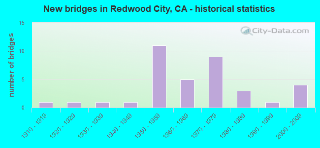
- New bridges - historical statistics
- 11910-1919
- 11920-1929
- 11930-1939
- 11940-1949
- 111950-1959
- 51960-1969
- 91970-1979
- 31980-1989
- 11990-1999
- 42000-2009

- Reconstructed bridges - Historical Statistics
- 51960-1969
- 11970-1979
- 11980-1989


- Bridge Condition - Deck
- 47.6%Good
- 14.3%Satisfactory
- 19.0%Fair
- 19.0%Poor

- Bridge Condition - Superstructure
- 52.4%Good
- 19.0%Satisfactory
- 28.6%Fair

- Bridge Condition - Substructure
- 85.7%Good
- 9.5%Fair
- 4.8%Poor

- Bridge Condition - Channel
- 7.1%Excellent
- 50.0%Very good
- 21.4%Good
- 14.3%Satisfactory
- 7.1%Fair

- Bridge Condition - Culverts
- 66.7%Good
- 16.7%Satisfactory
- 16.7%Poor
Find on map >> Show street view
Structure Number: 35 0019, Location: 04-SM-101-7.13-RDWC (Lat: 37.500292, Lng: -122.240336), Route carried "on" structure: US 101, Year Built: 1930, Year Reconstructed: 1971, Status: Open, Structure Length: 1.01m (3.31ft), Average Daily Traffic: 195,000 (year 2009), Truck Traffic: 5%, Average Future Daily Traffic: 256,126 (year 2039), Design Load: H 15, Features Intersected: CORDILLERAS CREEK
Minimum Vertical Clearance: 30+ m (98+ ft), Kilometerpoint: 7.130, Lanes on structure: 10, Base Highway Network: Yes (Inventory Route: 1, Subroute: 1), Owner: State Highway Agency, Approaching Roadway Width: 38.4m (126.0ft), Skew: 30 degrees, Material/Design: Concrete continuous, Design/Construction: Culvert, Number Of Spans In Main Unit: 3, Length of Maximum Span: 3.0m (9.8ft)
Condition: Channel: Fair, Culverts: Poor, Operating Rating: 40.5 metric tons, Method Used To Determine Operating Rating: Field evaluation and documented engineering judgment, Inventory Rating: 24.3 metric tons, Method Used To Determine Inventory Rating: Field evaluation and documented engineering judgment, Structural Evaluation: Meets minimum limits, Waterway Adequacy: Somewhat better than minimum adequacy, Approach Roadway Alignment: Equal to present desirable criteria, Length Of Structure Improvement: 1.01m (3.31ft), Designated Inspection Frequency: Every 24 months, Inspection Date: August 2021, Bridge Improvement Cost: $1,269,000, Roadway Improvement Cost: $253,000, Total Project Cost: $2,132,000 ( Estimate for 2017)
Find on map >> Show street view
Structure Number: 35 0052, Location: 04-SM-084-24.86-RDWC (Lat: 37.478889, Lng: -122.220442), Route carried "on" structure: State highway 84, Year Built: 1965, Status: Open, Structure Length: 8.06m (26.44ft), Average Daily Traffic: 43,000 (year 2009), Truck Traffic: 3%, Average Future Daily Traffic: 54,966 (year 2037), Design Load: HS 20, Features Intersected: CALTRAIN,UP RR,SHASTA ST
Minimum Vertical Clearance: 30+ m (98+ ft), Kilometerpoint: 24.860, Lanes on structure: 4, Lanes under structure: 2, Base Highway Network: Yes (, Subroute: 1), Owner: State Highway Agency, Approaching Roadway Width: 27.7m (90.9ft), Skew: 39 degrees, Material/Design: Steel, Design/Construction: Stringer/Multi-beam, Number Of Spans In Main Unit: 4, Length of Maximum Span: 35.4m (116.1ft), Curb or Sidewalk Widths: Left: 2.4m (7.9ft), Right: 0.6m (2.0ft), Curb-To-Curb Width: 22.0m (72.2ft), Out-to-Out Width: 28.7m (94.2ft)
Condition: Deck: Fair, Superstructure: Good, Substructure: Good, Operating Rating: 82.6 metric tons, Method Used To Determine Operating Rating: Load Factor (LF), Inventory Rating: 49.6 metric tons, Method Used To Determine Inventory Rating: Load Factor (LF), Structural Evaluation: Better than present minimum criteria, Deck Geometry: Better than present minimum criteria, Underclear: Meets minimum limits, Approach Roadway Alignment: Equal to present desirable criteria, Designated Inspection Frequency: Every 24 months, Other Special Inspection Frequency: Every 48 months, Inspection Date: May 2020, Other Special Inspection Date: March 2021, Deck Structure Type: Concrete Cast-file-Place
Find on map >> Show street view
Structure Number: 35 0065, Location: 04-SM-101-5.50-RDWC (Lat: 37.489717, Lng: -122.214192), Route carried "on" structure: US 101, Year Built: 1958, Year Reconstructed: 1972, Status: Open, Structure Length: 4.02m (13.19ft), Average Daily Traffic: 195,000 (year 2009), Truck Traffic: 5%, Average Future Daily Traffic: 256,126 (year 2039), Design Load: H 20, Features Intersected: UP RR SPUR
Minimum Vertical Clearance: 30+ m (98+ ft), Kilometerpoint: 5.500, Lanes on structure: 11, Base Highway Network: Yes (Inventory Route: 1, Subroute: 1), Owner: State Highway Agency, Approaching Roadway Width: 42.1m (138.1ft), Skew: 34 degrees, Material/Design: Concrete continuous, Design/Construction: Slab, Number Of Spans In Main Unit: 3, Length of Maximum Span: 13.4m (44.0ft), Curb-To-Curb Width: 59.4m (194.9ft), Out-to-Out Width: 65.8m (215.9ft)
Condition: Deck: Satisfactory, Superstructure: Satisfactory, Substructure: Good, Operating Rating: 59.6 metric tons, Method Used To Determine Operating Rating: Load and Resistance Factor Rating (LRFR) rating reported by rating factor(RF) method using HL-93 loadings, Inventory Rating: 46.0 metric tons, Method Used To Determine Inventory Rating: Load and Resistance Factor Rating (LRFR) rating reported by rating factor(RF) method using HL-93 loadings, Structural Evaluation: Equal to present minimum criteria, Deck Geometry: Superior to present desirable criteria, Underclear: Somewhat better than minimum adequacy, Approach Roadway Alignment: Equal to present desirable criteria, Designated Inspection Frequency: Every 48 months, Inspection Date: August 2021, Deck Structure Type: Concrete Cast-file-Place, Wearing Surface/Protective System: Wearing Surface: Bituminous
Find on map >> Show street view
Structure Number: 35 0065F, Location: 04-SM-101-5.50-RDWC (Lat: 37.488692, Lng: -122.214525), Route carried "on" structure: Ramp US 101, Year Built: 1972, Status: Open, Structure Length: 11.77m (38.62ft), Average Daily Traffic: 12,200 (year 1998), Truck Traffic: 2%, Average Future Daily Traffic: 27,323 (year 2043), Design Load: HS 20+Mod, Features Intersected: UP RR SPUR & VETERANS BL
Minimum Vertical Clearance: 30+ m (98+ ft), Kilometerpoint: 5.500, Lanes on structure: 1, Lanes under structure: 2, Base Highway Network: Yes, Owner: State Highway Agency, Approaching Roadway Width: 6.1m (20.0ft), Skew: 9 degrees, Material/Design: Concrete continuous, Design/Construction: Box Beam or Girders - Multiple, Number Of Spans In Main Unit: 5, Length of Maximum Span: 24.7m (81.0ft), Curb-To-Curb Width: 7.3m (24.0ft), Out-to-Out Width: 7.9m (25.9ft)
Condition: Deck: Good, Superstructure: Good, Substructure: Good, Operating Rating: 86.1 metric tons, Method Used To Determine Operating Rating: Load Factor (LF), Inventory Rating: 51.7 metric tons, Method Used To Determine Inventory Rating: Load Factor (LF), Structural Evaluation: Better than present minimum criteria, Deck Geometry: Better than present minimum criteria, Underclear: High priority of corrective action, Approach Roadway Alignment: Equal to present minimum criteria, Designated Inspection Frequency: Every 24 months, Inspection Date: August 2021, Deck Structure Type: Concrete Cast-file-Place
Find on map >> Show street view
Structure Number: 35 0083, Location: 04-SM-101-5.39-RDWC (Lat: 37.489067, Lng: -122.212325), Route carried "on" structure: US 101, Year Built: 1958, Year Reconstructed: 1972, Status: Open, Structure Length: 4.58m (15.03ft), Average Daily Traffic: 199,000 (year 2009), Truck Traffic: 4%, Average Future Daily Traffic: 251,547 (year 2039), Design Load: H 20, Features Intersected: SR 84 (WOODSIDE ROAD)
Minimum Vertical Clearance: 30+ m (98+ ft), Kilometerpoint: 5.390, Lanes on structure: 9, Lanes under structure: 5, Base Highway Network: Yes (Inventory Route: 1, Subroute: 1), Owner: State Highway Agency, Approaching Roadway Width: 56.1m (184.1ft), Skew: 32 degrees, Material/Design: Prestressed concrete, Design/Construction: Stringer/Multi-beam, Number Of Spans In Main Unit: 2, Length of Maximum Span: 22.9m (75.1ft), Curb-To-Curb Width: 55.5m (182.1ft), Out-to-Out Width: 63.4m (208.0ft)
Condition: Deck: Good, Superstructure: Good, Substructure: Good, Operating Rating: 54.4 metric tons, Method Used To Determine Operating Rating: Load Factor (LF), Inventory Rating: 32.4 metric tons, Method Used To Determine Inventory Rating: Load Factor (LF), Structural Evaluation: Better than present minimum criteria, Deck Geometry: Superior to present desirable criteria, Underclear: High priority of corrective action, Approach Roadway Alignment: Equal to present desirable criteria, Designated Inspection Frequency: Every 24 months, Inspection Date: August 2021, Deck Structure Type: Concrete Cast-file-Place, Wearing Surface/Protective System: Wearing Surface: Bituminous
Find on map >> Show street view
Structure Number: 35 0087, Location: 04-SM-101-5.88-RDWC (Lat: 37.491881, Lng: -122.220789), Route carried "on" structure: City street , Year Built: 1958, Status: Open, Structure Length: 5.27m (17.29ft), Average Daily Traffic: 5,960 (year 2004), Truck Traffic: 3%, Average Future Daily Traffic: 13,348 (year 2043), Design Load: HS 20, Features Intersected: US HIGHWAY 101, Facility Carried by Structure: MAPLE STREET
Minimum Vertical Clearance: 30+ m (98+ ft), Kilometerpoint: 0.000, Lanes on structure: 2, Lanes under structure: 8, Owner: State Highway Agency, Approaching Roadway Width: 7.9m (25.9ft), Material/Design: Prestressed concrete, Design/Construction: Tee Beam, Number Of Spans In Main Unit: 2, Length of Maximum Span: 25.4m (83.3ft), Curb or Sidewalk Widths: Left: 0.6m (2.0ft), Right: 1.6m (5.2ft), Curb-To-Curb Width: 8.4m (27.6ft), Out-to-Out Width: 10.6m (34.8ft)
Condition: Deck: Good, Superstructure: Good, Substructure: Good, Operating Rating: 53.8 metric tons, Method Used To Determine Operating Rating: Load Factor (LF), Inventory Rating: 32.4 metric tons, Method Used To Determine Inventory Rating: Load Factor (LF), Structural Evaluation: Better than present minimum criteria, Deck Geometry: High priority of replacement, Underclear: High priority of corrective action, Approach Roadway Alignment: Equal to present desirable criteria, Designated Inspection Frequency: Every 24 months, Inspection Date: August 2021, Deck Structure Type: Concrete Cast-file-Place, Wearing Surface/Protective System: Wearing Surface: Bituminous
Find on map >> Show street view
Structure Number: 35 0121, Location: 04-SM-101-21.80-SSF (Lat: 37.651456, Lng: -122.406619), Route carried "on" structure: US 101, Year Built: 1948, Year Reconstructed: 1969, Status: Open, Structure Length: 4.57m (14.99ft), Average Daily Traffic: 188,000 (year 2009), Truck Traffic: 4%, Average Future Daily Traffic: 267,887 (year 2039), Design Load: HS 20, Features Intersected: UP RR SPUR
Minimum Vertical Clearance: 30+ m (98+ ft), Kilometerpoint: 21.800, Lanes on structure: 9, Base Highway Network: Yes (Inventory Route: 1, Subroute: 1), Owner: State Highway Agency, Approaching Roadway Width: 43.3m (142.1ft), Skew: 30 degrees, Material/Design: Steel continuous, Design/Construction: Stringer/Multi-beam, Number Of Spans In Main Unit: 3, Length of Maximum Span: 16.5m (54.1ft), Curb-To-Curb Width: 42.7m (140.1ft), Out-to-Out Width: 43.9m (144.0ft)
Condition: Deck: Good, Superstructure: Good, Substructure: Good, Operating Rating: 64.2 metric tons, Method Used To Determine Operating Rating: Load Factor (LF), Inventory Rating: 38.6 metric tons, Method Used To Determine Inventory Rating: Load Factor (LF), Structural Evaluation: Better than present minimum criteria, Deck Geometry: Superior to present desirable criteria, Underclear: Somewhat better than minimum adequacy, Approach Roadway Alignment: Equal to present desirable criteria, Designated Inspection Frequency: Every 24 months, Inspection Date: April 2021, Deck Structure Type: Concrete Cast-file-Place, Wearing Surface/Protective System: Wearing Surface: Monolithic Concrete
Find on map >> Show street view
Structure Number: 35 0122, Location: 04-SM-101-6.62-RDWC (Lat: 37.496081, Lng: -122.233081), Route carried "on" structure: City street D052, Year Built: 1958, Year Reconstructed: 1984, Status: Open, Structure Length: 5.27m (17.29ft), Average Daily Traffic: 201,000 (year 2000), Truck Traffic: 7%, Average Future Daily Traffic: 399,464 (year 2041), Design Load: HS 20, Features Intersected: US HIGHWAY 101, Facility Carried by Structure: WHIPPLE AVENUE
Minimum Vertical Clearance: 30+ m (98+ ft), Kilometerpoint: 0.000, Lanes on structure: 4, Lanes under structure: 10, Owner: State Highway Agency, Approaching Roadway Width: 21.3m (69.9ft), Material/Design: Prestressed concrete, Design/Construction: Stringer/Multi-beam, Number Of Spans In Main Unit: 2, Length of Maximum Span: 25.3m (83.0ft), Curb or Sidewalk Widths: Left: 0.0m, Right: 1.5m (4.9ft), Curb-To-Curb Width: 21.3m (69.9ft), Out-to-Out Width: 23.6m (77.4ft)
Condition: Deck: Good, Superstructure: Good, Substructure: Good, Operating Rating: 40.2 metric tons, Method Used To Determine Operating Rating: Load and Resistance Factor Rating (LRFR) rating reported by rating factor(RF) method using HL-93 loadings, Inventory Rating: 23.0 metric tons, Method Used To Determine Inventory Rating: Load and Resistance Factor Rating (LRFR) rating reported by rating factor(RF) method using HL-93 loadings, Structural Evaluation: Somewhat better than minimum adequacy, Deck Geometry: Superior to present desirable criteria, Underclear: High priority of corrective action, Approach Roadway Alignment: Equal to present desirable criteria, Designated Inspection Frequency: Every 24 months, Inspection Date: August 2021, Deck Structure Type: Concrete Cast-file-Place, Wearing Surface/Protective System: Wearing Surface: Bituminous
Find on map >> Show street view
Structure Number: 35 014, Location: 04-SM-101-11.67-SM (Lat: 37.550767, Lng: -122.293450), Route carried "on" structure: US 101, Year Built: 1954, Year Reconstructed: 1985, Status: Open, Structure Length: 1.01m (3.31ft), Average Daily Traffic: 195,000 (year 2009), Truck Traffic: 5%, Average Future Daily Traffic: 265,675 (year 2043), Design Load: HS 20, Features Intersected: BOREL CREEK
Minimum Vertical Clearance: 30+ m (98+ ft), Kilometerpoint: 11.670, Lanes on structure: 11, Base Highway Network: Yes (Inventory Route: 1, Subroute: 1), Owner: State Highway Agency, Approaching Roadway Width: 78.6m (257.9ft), Skew: 30 degrees, Material/Design: Concrete continuous, Design/Construction: Slab, Number Of Spans In Main Unit: 2, Length of Maximum Span: 9.4m (30.8ft), Curb-To-Curb Width: 78.6m (257.9ft), Out-to-Out Width: 79.9m (262.1ft)
Condition: Deck: Good, Superstructure: Good, Substructure: Good, Channel: Very good, Operating Rating: 54.1 metric tons, Method Used To Determine Operating Rating: Assigned rating based on Load Factor Design (LFD) reported in metric tons, Inventory Rating: 32.4 metric tons, Method Used To Determine Inventory Rating: Assigned rating based on Load Factor Design (LFD) reported in metric tons, Structural Evaluation: Better than present minimum criteria, Deck Geometry: Superior to present desirable criteria, Waterway Adequacy: Equal to present desirable criteria, Approach Roadway Alignment: Equal to present desirable criteria, Designated Inspection Frequency: Every 24 months, Inspection Date: August 2021, Deck Structure Type: Concrete Cast-file-Place, Wearing Surface/Protective System: Wearing Surface: Bituminous
Find on map >> Show street view
Structure Number: 35 0145, Location: 04-SM-101-6.20-RDWC (Lat: 37.494347, Lng: -122.225519), Route carried "on" structure: US 101, Year Built: 1958, Year Reconstructed: 1972, Status: Open, Structure Length: 11.40m (37.40ft), Average Daily Traffic: 195,000 (year 2009), Truck Traffic: 5%, Average Future Daily Traffic: 256,126 (year 2039), Design Load: HS 20, Features Intersected: REDWOOD CREEK
Minimum Vertical Clearance: 30+ m (98+ ft), Kilometerpoint: 6.200, Lanes on structure: 10, Base Highway Network: Yes (Inventory Route: 1, Subroute: 1), Owner: State Highway Agency, Approaching Roadway Width: 48.6m (159.4ft), Skew: 32 degrees, Material/Design: Concrete continuous, Design/Construction: Slab, Number Of Spans In Main Unit: 11, Length of Maximum Span: 10.4m (34.1ft), Curb-To-Curb Width: 48.6m (159.4ft), Out-to-Out Width: 50.0m (164.0ft)
Condition: Deck: Satisfactory, Superstructure: Satisfactory, Substructure: Good, Channel: Good, Operating Rating: 38.9 metric tons, Method Used To Determine Operating Rating: Load and Resistance Factor Rating (LRFR) rating reported by rating factor(RF) method using HL-93 loadings, Inventory Rating: 30.1 metric tons, Method Used To Determine Inventory Rating: Load and Resistance Factor Rating (LRFR) rating reported by rating factor(RF) method using HL-93 loadings, Structural Evaluation: Equal to present minimum criteria, Deck Geometry: Superior to present desirable criteria, Waterway Adequacy: Equal to present desirable criteria, Approach Roadway Alignment: Equal to present desirable criteria, Designated Inspection Frequency: Every 24 months, Inspection Date: August 2021, Deck Structure Type: Concrete Cast-file-Place
Find on map >> Show street view
Structure Number: 35 0250R, Location: 04-SM-280-6.65 (Lat: 37.468414, Lng: -122.292014), Route carried "on" structure: Interstate 280, Year Built: 1973, Status: Open, Structure Length: 6.12m (20.08ft), Average Daily Traffic: 55,500 (year 2009), Truck Traffic: 3%, Average Future Daily Traffic: 169,818 (year 2038), Features Intersected: EDGEWOOD ROAD
Minimum Vertical Clearance: 30+ m (98+ ft), Kilometerpoint: 6.650, Lanes on structure: 4, Lanes under structure: 4, Base Highway Network: Yes (Inventory Route: 2, Subroute: 1), Owner: State Highway Agency, Approaching Roadway Width: 20.1m (65.9ft), Skew: 2 degrees, Material/Design: Concrete continuous, Design/Construction: Box Beam or Girders - Multiple, Number Of Spans In Main Unit: 2, Length of Maximum Span: 30.6m (100.4ft), Curb-To-Curb Width: 20.1m (65.9ft), Out-to-Out Width: 21.2m (69.6ft)
Condition: Deck: Satisfactory, Superstructure: Fair, Substructure: Fair, Operating Rating: 73.2 metric tons, Method Used To Determine Operating Rating: Load and Resistance Factor Rating (LRFR) rating reported by rating factor(RF) method using HL-93 loadings, Inventory Rating: 56.4 metric tons, Method Used To Determine Inventory Rating: Load and Resistance Factor Rating (LRFR) rating reported by rating factor(RF) method using HL-93 loadings, Structural Evaluation: Somewhat better than minimum adequacy, Deck Geometry: Equal to present minimum criteria, Underclear: Somewhat better than minimum adequacy, Approach Roadway Alignment: Equal to present desirable criteria, Designated Inspection Frequency: Every 24 months, Inspection Date: October 2021, Deck Structure Type: Concrete Cast-file-Place
Find on map >> Show street view
Structure Number: 35 0277L, Location: 04-SM-280-R6.99 (Lat: 37.465514, Lng: -122.291097), Route carried "on" structure: Interstate 280, Year Built: 1973, Status: Open, Structure Length: 3.49m (11.45ft), Average Daily Traffic: 50,000 (year 2009), Truck Traffic: 3%, Average Future Daily Traffic: 67,280 (year 2038), Design Load: HS 20, Features Intersected: SERVICE ROAD
Minimum Vertical Clearance: 30+ m (98+ ft), Kilometerpoint: 6.990, Lanes on structure: 4, Base Highway Network: Yes (Inventory Route: 2, Subroute: 1), Owner: State Highway Agency, Approaching Roadway Width: 20.1m (65.9ft), Material/Design: Prestressed concrete, Design/Construction: Box Beam or Girders - Multiple, Number Of Spans In Main Unit: 1, Length of Maximum Span: 34.1m (111.9ft), Curb-To-Curb Width: 20.1m (65.9ft), Out-to-Out Width: 21.2m (69.6ft)
Condition: Deck: Poor, Superstructure: Satisfactory, Substructure: Good, Operating Rating: 84.9 metric tons, Method Used To Determine Operating Rating: Load Factor (LF), Inventory Rating: 32.4 metric tons, Method Used To Determine Inventory Rating: Load Factor (LF), Structural Evaluation: Equal to present minimum criteria, Deck Geometry: Equal to present minimum criteria, Approach Roadway Alignment: Equal to present desirable criteria, Designated Inspection Frequency: Every 24 months, Inspection Date: October 2021, Deck Structure Type: Concrete Cast-file-Place
Find on map >> Show street view
Structure Number: 35 0277R, Location: 04-SM-280-R6.99 (Lat: 37.465569, Lng: -122.290775), Route carried "on" structure: Interstate 280, Year Built: 1973, Status: Open, Structure Length: 3.46m (11.35ft), Average Daily Traffic: 50,000 (year 2009), Truck Traffic: 3%, Average Future Daily Traffic: 80,658 (year 2038), Design Load: HS 20, Features Intersected: SERVICE ROAD
Minimum Vertical Clearance: 30+ m (98+ ft), Kilometerpoint: 6.990, Lanes on structure: 5, Base Highway Network: Yes (Inventory Route: 2, Subroute: 1), Owner: State Highway Agency, Approaching Roadway Width: 23.2m (76.1ft), Material/Design: Prestressed concrete, Design/Construction: Box Beam or Girders - Multiple, Number Of Spans In Main Unit: 1, Length of Maximum Span: 33.8m (110.9ft), Curb-To-Curb Width: 23.2m (76.1ft), Out-to-Out Width: 24.3m (79.7ft)
Condition: Deck: Poor, Superstructure: Satisfactory, Substructure: Good, Operating Rating: 83.6 metric tons, Method Used To Determine Operating Rating: Load Factor (LF), Inventory Rating: 32.4 metric tons, Method Used To Determine Inventory Rating: Load Factor (LF), Structural Evaluation: Equal to present minimum criteria, Deck Geometry: Somewhat better than minimum adequacy, Approach Roadway Alignment: Equal to present desirable criteria, Designated Inspection Frequency: Every 24 months, Inspection Date: October 2021, Deck Structure Type: Concrete Cast-file-Place
Find on map >> Show street view
Structure Number: 35 0331L, Location: 04-SM-001-R39.93-PFA (Lat: 37.582739, Lng: -122.509747), Route carried "on" structure: State highway 1, Year Built: 2009, Status: Open, Structure Length: 29.64m (97.24ft), Average Daily Traffic: 14,500 (year 2009), Truck Traffic: 1%, Average Future Daily Traffic: 40,738 (year 2037), Design Load: HS 20, Features Intersected: DEVIL SLIDE
Minimum Vertical Clearance: 30+ m (98+ ft), Kilometerpoint: 39.930, Lanes on structure: 1, Base Highway Network: Yes (, Subroute: 1), Owner: State Highway Agency, Approaching Roadway Width: 7.8m (25.6ft), Material/Design: Prestressed concrete, Design/Construction: Segmental Box Girder, Number Of Spans In Main Unit: 3, Length of Maximum Span: 135.0m (442.9ft), Curb-To-Curb Width: 7.8m (25.6ft), Out-to-Out Width: 8.9m (29.2ft)
Condition: Deck: Good, Superstructure: Good, Substructure: Good, Operating Rating: 54.1 metric tons, Method Used To Determine Operating Rating: Assigned rating based on Load Factor Design (LFD) reported in metric tons, Inventory Rating: 32.4 metric tons, Method Used To Determine Inventory Rating: Assigned rating based on Load Factor Design (LFD) reported in metric tons, Structural Evaluation: Better than present minimum criteria, Deck Geometry: High priority of replacement, Approach Roadway Alignment: Equal to present desirable criteria, Designated Inspection Frequency: Every 24 months, Inspection Date: October 2020, Deck Structure Type: Concrete Cast-file-Place
Find on map >> Show street view
Structure Number: 35 0337, Location: 04-SM-101-9.60-RDWC (Lat: 37.527697, Lng: -122.269378), Route carried "on" structure: Business City street , Year Built: 2004, Status: Open, Structure Length: 2.26m (7.41ft), Average Daily Traffic: 2,500 (year 2011), Truck Traffic: 3%, Average Future Daily Traffic: 3,217 (year 2043), Design Load: HS 20, Features Intersected: MARINE PKWY TO NB 101, Facility Carried by Structure: ISLAND PARKWAY
Minimum Vertical Clearance: 30+ m (98+ ft), Kilometerpoint: 0.000, Lanes on structure: 4, Lanes under structure: 3, Owner: State Highway Agency, Approaching Roadway Width: 25.1m (82.3ft), Skew: 20 degrees, Material/Design: Prestressed concrete, Design/Construction: Slab, Number Of Spans In Main Unit: 1, Length of Maximum Span: 22.6m (74.1ft), Curb or Sidewalk Widths: Left: 0.0m, Right: 1.5m (4.9ft), Curb-To-Curb Width: 22.6m (74.1ft), Out-to-Out Width: 25.1m (82.3ft)
Condition: Deck: Good, Superstructure: Good, Substructure: Good, Operating Rating: 54.1 metric tons, Method Used To Determine Operating Rating: Assigned rating based on Load Factor Design (LFD) reported in metric tons, Inventory Rating: 32.4 metric tons, Method Used To Determine Inventory Rating: Assigned rating based on Load Factor Design (LFD) reported in metric tons, Structural Evaluation: Better than present minimum criteria, Deck Geometry: Superior to present desirable criteria, Underclear: Equal to present desirable criteria, Approach Roadway Alignment: Equal to present desirable criteria, Designated Inspection Frequency: Every 48 months, Inspection Date: August 2021, Deck Structure Type: Concrete Cast-file-Place
Find on map >> Show street view
Structure Number: 35C0013, Location: BTWN MAIN ST & JEFFSN AVE (Lat: 37.488600, Lng: -122.227169), Route carried "on" structure: City street , Year Built: 1966, Status: Open, Structure Length: 0.97m (3.18ft), Average Daily Traffic: 2,000 (year 2015), Truck Traffic: 15%, Average Future Daily Traffic: 1,087 (year 2040), Design Load: H 20, Features Intersected: REDWOOD CREEK, Facility Carried by Structure: BRADFORD ST
Minimum Vertical Clearance: 30+ m (98+ ft), Kilometerpoint: 0.000, Lanes on structure: 2, Owner: City or Municipal Highway Agency, Approaching Roadway Width: 18.3m (60.0ft), Material/Design: Concrete continuous, Design/Construction: Culvert, Number Of Spans In Main Unit: 2, Length of Maximum Span: 4.6m (15.1ft), Curb or Sidewalk Widths: Left: 1.8m (5.9ft), Right: 1.8m (5.9ft), Curb-To-Curb Width: 18.3m (60.0ft), Out-to-Out Width: 22.0m (72.2ft)
Condition: Channel: Very good, Culverts: Satisfactory, Operating Rating: 54.1 metric tons, Method Used To Determine Operating Rating: Field evaluation and documented engineering judgment, Inventory Rating: 32.4 metric tons, Method Used To Determine Inventory Rating: Field evaluation and documented engineering judgment, Structural Evaluation: Equal to present minimum criteria, Deck Geometry: Superior to present desirable criteria, Waterway Adequacy: Superior to present desirable criteria, Approach Roadway Alignment: Equal to present desirable criteria, Designated Inspection Frequency: Every 24 months, Inspection Date: April 2020, Deck Structure Type: Concrete Cast-file-Place, Wearing Surface/Protective System: Wearing Surface: Bituminous
Find on map >> Show street view
Structure Number: 35C0033, Location: @ VETERANS BLVD (Lat: 37.489408, Lng: -122.226425), Route carried "on" structure: City street , Year Built: 1989, Status: Open, Structure Length: 1.95m (6.40ft), Average Daily Traffic: 9,000 (year 2018), Truck Traffic: 15%, Average Future Daily Traffic: 5,292 (year 2042), Design Load: HS 20+Mod, Features Intersected: REDWOOD CREEK, Facility Carried by Structure: MAIN ST
Minimum Vertical Clearance: 30+ m (98+ ft), Kilometerpoint: 0.000, Lanes on structure: 4, Base Highway Network: Yes, Owner: City or Municipal Highway Agency, Approaching Roadway Width: 17.6m (57.7ft), Skew: 1 degrees, Material/Design: Concrete continuous, Design/Construction: Slab, Number Of Spans In Main Unit: 2, Length of Maximum Span: 9.4m (30.8ft), Curb or Sidewalk Widths: Left: 1.5m (4.9ft), Right: 1.5m (4.9ft), Curb-To-Curb Width: 17.6m (57.7ft), Out-to-Out Width: 20.6m (67.6ft)
Condition: Deck: Fair, Superstructure: Fair, Substructure: Good, Channel: Very good, Operating Rating: 54.1 metric tons, Method Used To Determine Operating Rating: Assigned rating based on Load Factor Design (LFD) reported in metric tons, Inventory Rating: 32.4 metric tons, Method Used To Determine Inventory Rating: Assigned rating based on Load Factor Design (LFD) reported in metric tons, Structural Evaluation: Somewhat better than minimum adequacy, Deck Geometry: Somewhat better than minimum adequacy, Waterway Adequacy: Superior to present desirable criteria, Approach Roadway Alignment: Equal to present desirable criteria, Designated Inspection Frequency: Every 24 months, Inspection Date: April 2020, Deck Structure Type: Concrete Cast-file-Place
Find on map >> Show street view
Structure Number: 35C0034, Location: EAST OF MAIN ST (Lat: 37.489814, Lng: -122.226075), Route carried "on" structure: City street , Year Built: 1990, Status: Open, Structure Length: 3.63m (11.91ft), Average Daily Traffic: 26,000 (year 2018), Truck Traffic: 5%, Average Future Daily Traffic: 36,827 (year 2041), Design Load: HS 20+Mod, Features Intersected: REDWOOD CREEK, Facility Carried by Structure: VETERANS BLVD
Minimum Vertical Clearance: 30+ m (98+ ft), Kilometerpoint: 0.000, Lanes on structure: 7, Owner: City or Municipal Highway Agency, Approaching Roadway Width: 26.8m (87.9ft), Skew: 30 degrees, Material/Design: Prestressed concrete continuous, Design/Construction: Slab, Number Of Spans In Main Unit: 2, Length of Maximum Span: 18.6m (61.0ft), Curb or Sidewalk Widths: Left: 2.7m (8.9ft), Right: 1.5m (4.9ft), Curb-To-Curb Width: 31.7m (104.0ft), Out-to-Out Width: 31.7m (104.0ft)
Condition: Deck: Fair, Superstructure: Fair, Substructure: Good, Channel: Good, Operating Rating: 54.1 metric tons, Method Used To Determine Operating Rating: Assigned rating based on Load Factor Design (LFD) reported in metric tons, Inventory Rating: 32.4 metric tons, Method Used To Determine Inventory Rating: Assigned rating based on Load Factor Design (LFD) reported in metric tons, Structural Evaluation: Somewhat better than minimum adequacy, Deck Geometry: Superior to present desirable criteria, Waterway Adequacy: Equal to present desirable criteria, Approach Roadway Alignment: Equal to present minimum criteria, Designated Inspection Frequency: Every 24 months, Inspection Date: April 2020, Deck Structure Type: Concrete Cast-file-Place, Wearing Surface/Protective System: Deck Protection: Epoxy Coated Reinforcing
Find on map >> Show street view
Structure Number: 35C0073, Location: EAST OF S.H. 101 (Lat: 37.527714, Lng: -122.267878), Route carried "on" structure: City street , Year Built: 1968, Status: Open, Structure Length: 1.01m (3.31ft), Average Daily Traffic: 8,200 (year 2010), Truck Traffic: 10%, Average Future Daily Traffic: 10,688 (year 2040), Features Intersected: BELMONT SLOUGH, Facility Carried by Structure: MARINE PKWY
Minimum Vertical Clearance: 30+ m (98+ ft), Kilometerpoint: 0.000, Lanes on structure: 11, Owner: City or Municipal Highway Agency, Approaching Roadway Width: 34.4m (112.9ft), Skew: 20 degrees, Material/Design: Concrete continuous, Design/Construction: Culvert, Number Of Spans In Main Unit: 3, Length of Maximum Span: 3.4m (11.2ft), Curb-To-Curb Width: 34.4m (112.9ft), Out-to-Out Width: 34.4m (112.9ft)
Condition: Channel: Good, Culverts: Good, Operating Rating: 40.5 metric tons, Method Used To Determine Operating Rating: Field evaluation and documented engineering judgment, Inventory Rating: 24.3 metric tons, Method Used To Determine Inventory Rating: Field evaluation and documented engineering judgment, Structural Evaluation: Equal to present minimum criteria, Deck Geometry: High priority of replacement, Waterway Adequacy: Equal to present desirable criteria, Approach Roadway Alignment: Equal to present desirable criteria, Designated Inspection Frequency: Every 24 months, Inspection Date: April 2020
Find on map >> Show street view
Structure Number: 35C0074L, Location: EAST OF MARINE PKWY (Lat: 37.528878, Lng: -122.254350), Route carried "on" structure: City street , Year Built: 1971, Status: Open, Structure Length: 25.91m (85.01ft), Average Daily Traffic: 1,000 (year 2019), Truck Traffic: 10%, Average Future Daily Traffic: 1,332 (year 2040), Design Load: HS 20, Features Intersected: REDWOOD SHORES LAGOON, Facility Carried by Structure: BRIDGE DR PARKWAY
Minimum Vertical Clearance: 30+ m (98+ ft), Kilometerpoint: 0.000, Lanes on structure: 2, Owner: City or Municipal Highway Agency, Approaching Roadway Width: 8.2m (26.9ft), Skew: 20 degrees, Material/Design: Concrete continuous, Design/Construction: Box Beam or Girders - Multiple, Number Of Spans In Main Unit: 11, Number Of Approach Spans: 2, Length of Maximum Span: 24.4m (80.1ft), Curb or Sidewalk Widths: Left: 0.6m (2.0ft), Right: 0.6m (2.0ft), Curb-To-Curb Width: 7.9m (25.9ft), Out-to-Out Width: 9.1m (29.9ft)
Condition: Deck: Poor, Superstructure: Good, Substructure: Good, Channel: Satisfactory, Operating Rating: 46.3 metric tons, Method Used To Determine Operating Rating: Load and Resistance Factor Rating (LRFR) rating reported by rating factor(RF) method using HL-93 loadings, Inventory Rating: 33.0 metric tons, Method Used To Determine Inventory Rating: Load and Resistance Factor Rating (LRFR) rating reported by rating factor(RF) method using HL-93 loadings, Structural Evaluation: Better than present minimum criteria, Deck Geometry: High priority of replacement, Waterway Adequacy: Equal to present desirable criteria, Approach Roadway Alignment: Equal to present desirable criteria, Length Of Structure Improvement: 25.91m (85.01ft), Designated Inspection Frequency: Every 24 months, Underwater Inspection Frequency: Every 60 months, Inspection Date: April 2020, Underwater Inspection Date: July 2020, Bridge Improvement Cost: $2,369,000, Roadway Improvement Cost: $473,000, Total Project Cost: $3,979,000 ( Estimate for 2021), Deck Structure Type: Concrete Cast-file-Place
Find on map >> Show street view
Structure Number: 35C0074R, Location: EAST OF MARINE PKWY (Lat: 37.528961, Lng: -122.254250), Route carried "on" structure: City street , Year Built: 1971, Status: Open, Structure Length: 25.91m (85.01ft), Average Daily Traffic: 2,600 (year 2018), Truck Traffic: 10%, Average Future Daily Traffic: 5,632 (year 2042), Design Load: HS 20, Features Intersected: REDWOOD SHORES LAGOON, Facility Carried by Structure: BRIDGE DR PARKWAY
Minimum Vertical Clearance: 30+ m (98+ ft), Kilometerpoint: 0.000, Lanes on structure: 2, Owner: City or Municipal Highway Agency, Approaching Roadway Width: 8.2m (26.9ft), Material/Design: Concrete continuous, Design/Construction: Box Beam or Girders - Multiple, Number Of Spans In Main Unit: 11, Number Of Approach Spans: 2, Length of Maximum Span: 24.4m (80.1ft), Curb or Sidewalk Widths: Left: 0.3m (1.0ft), Right: 0.3m (1.0ft), Curb-To-Curb Width: 7.9m (25.9ft), Out-to-Out Width: 9.1m (29.9ft)
Condition: Deck: Poor, Superstructure: Good, Substructure: Fair, Channel: Satisfactory, Operating Rating: 46.3 metric tons, Method Used To Determine Operating Rating: Load and Resistance Factor Rating (LRFR) rating reported by rating factor(RF) method using HL-93 loadings, Inventory Rating: 33.4 metric tons, Method Used To Determine Inventory Rating: Load and Resistance Factor Rating (LRFR) rating reported by rating factor(RF) method using HL-93 loadings, Structural Evaluation: Somewhat better than minimum adequacy, Deck Geometry: High priority of replacement, Waterway Adequacy: Equal to present desirable criteria, Approach Roadway Alignment: Equal to present desirable criteria, Length Of Structure Improvement: 25.91m (85.01ft), Designated Inspection Frequency: Every 24 months, Underwater Inspection Frequency: Every 60 months, Inspection Date: April 2020, Underwater Inspection Date: July 2020, Bridge Improvement Cost: $5,448,000, Deck Structure Type: Concrete Cast-file-Place
Find on map >> Show street view
Structure Number: 35C0128, Location: NORTH LATHROP ST (Lat: 37.482119, Lng: -122.226344), Route carried "on" structure: City street , Year Built: 1919, Status: Open, Structure Length: 1.37m (4.49ft), Average Daily Traffic: 2,350 (year 2010), Truck Traffic: 10%, Average Future Daily Traffic: 1,087 (year 2040), Features Intersected: REDWOOD CREEK, Facility Carried by Structure: MAPLE ST
Minimum Vertical Clearance: 30+ m (98+ ft), Kilometerpoint: 0.000, Lanes on structure: 2, Owner: City or Municipal Highway Agency, Approaching Roadway Width: 9.1m (29.9ft), Skew: 6 degrees, Material/Design: Concrete, Design/Construction: Tee Beam, Number Of Spans In Main Unit: 1, Length of Maximum Span: 12.8m (42.0ft), Curb or Sidewalk Widths: Left: 2.7m (8.9ft), Right: 2.7m (8.9ft), Curb-To-Curb Width: 9.1m (29.9ft), Out-to-Out Width: 15.2m (49.9ft)
Condition: Deck: Good, Superstructure: Fair, Substructure: Good, Channel: Very good, Operating Rating: 41.8 metric tons, Method Used To Determine Operating Rating: Load Factor (LF), Inventory Rating: 24.9 metric tons, Method Used To Determine Inventory Rating: Load Factor (LF), Structural Evaluation: Somewhat better than minimum adequacy, Deck Geometry: Meets minimum limits, Waterway Adequacy: Equal to present desirable criteria, Approach Roadway Alignment: Equal to present desirable criteria, Designated Inspection Frequency: Every 24 months, Inspection Date: April 2020, Deck Structure Type: Concrete Cast-file-Place, Wearing Surface/Protective System: Wearing Surface: Bituminous
Find on map >> Show street view
Structure Number: 35C0129, Location: WEST OF MAPLE ST (Lat: 37.482672, Lng: -122.226353), Route carried "on" structure: City street , Year Built: 1989, Status: Open, Structure Length: 1.40m (4.59ft), Average Daily Traffic: 100 (year 2018), Average Future Daily Traffic: 261 (year 2042), Features Intersected: REDWOOD CREEK, Facility Carried by Structure: PENNSYLVANIA,UP RR
Minimum Vertical Clearance: 30+ m (98+ ft), Kilometerpoint: 0.000, Lanes on structure: 2, Owner: City or Municipal Highway Agency, Approaching Roadway Width: 4.6m (15.1ft), Skew: 6 degrees, Material/Design: Concrete continuous, Design/Construction: Culvert, Number Of Spans In Main Unit: 2, Length of Maximum Span: 7.0m (23.0ft), Curb-To-Curb Width: 6.5m (21.3ft), Out-to-Out Width: 6.5m (21.3ft)
Condition: Channel: Very good, Culverts: Good, Operating Rating: 54.1 metric tons, Method Used To Determine Operating Rating: Field evaluation and documented engineering judgment, Inventory Rating: 32.4 metric tons, Method Used To Determine Inventory Rating: Field evaluation and documented engineering judgment, Structural Evaluation: Better than present minimum criteria, Deck Geometry: Somewhat better than minimum adequacy, Waterway Adequacy: Equal to present desirable criteria, Approach Roadway Alignment: Equal to present minimum criteria, Designated Inspection Frequency: Every 48 months, Inspection Date: April 2020, Deck Structure Type: Concrete Cast-file-Place, Wearing Surface/Protective System: Wearing Surface: Bituminous
Find on map >> Show street view
Structure Number: 35C0153, Location: SOUTH OF MAPLE ST (Lat: 37.481381, Lng: -122.226097), Route carried "on" structure: City street , Year Built: 1955, Status: Open, Structure Length: 1.01m (3.31ft), Average Daily Traffic: 9,000 (year 2018), Truck Traffic: 10%, Average Future Daily Traffic: 10,688 (year 2040), Features Intersected: REDWOOD CREEK, Facility Carried by Structure: LATHROP ST
Minimum Vertical Clearance: 30+ m (98+ ft), Kilometerpoint: 0.000, Lanes on structure: 2, Owner: City or Municipal Highway Agency, Approaching Roadway Width: 8.5m (27.9ft), Skew: 4 degrees, Material/Design: Concrete continuous, Design/Construction: Culvert, Number Of Spans In Main Unit: 2, Length of Maximum Span: 4.6m (15.1ft), Curb or Sidewalk Widths: Left: 0.3m (1.0ft), Right: 0.3m (1.0ft), Curb-To-Curb Width: 8.5m (27.9ft), Out-to-Out Width: 9.1m (29.9ft)
Condition: Channel: Very good, Culverts: Good, Operating Rating: 40.5 metric tons, Method Used To Determine Operating Rating: Field evaluation and documented engineering judgment, Inventory Rating: 24.3 metric tons, Method Used To Determine Inventory Rating: Field evaluation and documented engineering judgment, Structural Evaluation: Equal to present minimum criteria, Deck Geometry: High priority of replacement, Waterway Adequacy: Equal to present desirable criteria, Approach Roadway Alignment: Equal to present desirable criteria, Designated Inspection Frequency: Every 24 months, Inspection Date: April 2020, Deck Structure Type: Concrete Cast-file-Place, Wearing Surface/Protective System: Wearing Surface: Bituminous
Find on map >> Show street view
Structure Number: 35C0169, Location: WEST OF MAPLE ST (Lat: 37.484092, Lng: -122.227022), Route carried "on" structure: City street , Year Built: 1989, Status: Open, Structure Length: 0.91m (2.99ft), Average Daily Traffic: 14,000 (year 2016), Truck Traffic: 2%, Average Future Daily Traffic: 17,811 (year 2042), Design Load: HS 20+Mod, Features Intersected: REDWOOD CREEK, Facility Carried by Structure: MIDDLEFIELD RD
Minimum Vertical Clearance: 30+ m (98+ ft), Kilometerpoint: 0.000, Lanes on structure: 4, Owner: City or Municipal Highway Agency, Approaching Roadway Width: 18.6m (61.0ft), Skew: 9 degrees, Material/Design: Concrete continuous, Design/Construction: Culvert, Number Of Spans In Main Unit: 2, Length of Maximum Span: 4.0m (13.1ft), Curb-To-Curb Width: 18.6m (61.0ft), Out-to-Out Width: 19.2m (63.0ft)
Condition: Channel: Very good, Culverts: Good, Operating Rating: 54.1 metric tons, Method Used To Determine Operating Rating: Field evaluation and documented engineering judgment, Inventory Rating: 32.4 metric tons, Method Used To Determine Inventory Rating: Field evaluation and documented engineering judgment, Structural Evaluation: Better than present minimum criteria, Deck Geometry: Equal to present minimum criteria, Waterway Adequacy: Equal to present desirable criteria, Approach Roadway Alignment: Equal to present desirable criteria, Designated Inspection Frequency: Every 48 months, Inspection Date: April 2020, Deck Structure Type: Concrete Cast-file-Place, Wearing Surface/Protective System: Wearing Surface: Bituminous
Find on map >> Show street view
Structure Number: 35C019, Location: 0.1 MI. W. OF PORTOLA RD (Lat: 37.395458, Lng: -122.247764), Route carried "on" structure: City street , Year Built: 1924, Status: Open, Structure Length: 0.90m (2.95ft), Average Daily Traffic: 120 (year 2016), Truck Traffic: 1%, Average Future Daily Traffic: 136 (year 2038), Features Intersected: DRAINAGE SWALE, Facility Carried by Structure: OLD LA HONDA ROAD
Minimum Vertical Clearance: 30+ m (98+ ft), Kilometerpoint: 0.000, Lanes on structure: 1, Owner: Town or Township Highway Agency, Approaching Roadway Width: 7.0m (23.0ft), Material/Design: Concrete, Design/Construction: Tee Beam, Number Of Spans In Main Unit: 1, Length of Maximum Span: 8.0m (26.2ft), Curb or Sidewalk Widths: Left: 0.3m (1.0ft), Right: 0.3m (1.0ft), Curb-To-Curb Width: 6.4m (21.0ft), Out-to-Out Width: 6.4m (21.0ft)
Condition: Deck: Good, Superstructure: Fair, Substructure: Poor, Channel: Excellent, Operating Rating: 27.2 metric tons, Method Used To Determine Operating Rating: Field evaluation and documented engineering judgment, Inventory Rating: 16.2 metric tons, Method Used To Determine Inventory Rating: Field evaluation and documented engineering judgment, Structural Evaluation: Meets minimum limits, Deck Geometry: Meets minimum limits, Waterway Adequacy: Meets minimum limits, Approach Roadway Alignment: Equal to present desirable criteria, Length Of Structure Improvement: 0.90m (2.95ft), Designated Inspection Frequency: Every 24 months, Inspection Date: April 2020, Bridge Improvement Cost: $131,000, Roadway Improvement Cost: $26,000, Total Project Cost: $220,000 ( Estimate for 2017), Deck Structure Type: Concrete Cast-file-Place, Wearing Surface/Protective System: Wearing Surface: Bituminous
Find on map >> Show street view
Structure Number: 35C0192, Location: 0.1 M. N. OF MARINE PKWY (Lat: 37.527697, Lng: -122.269375), Route carried "on" structure: Business City street , Year Built: 2004, Status: Open, Structure Length: 7.99m (26.21ft), Average Daily Traffic: 2,500 (year 2018), Truck Traffic: 3%, Average Future Daily Traffic: 3,081 (year 2042), Design Load: HS 20, Features Intersected: AUTOBAHN MOTORS, Facility Carried by Structure: ISLAND PARKWAY
Minimum Vertical Clearance: 30+ m (98+ ft), Kilometerpoint: 0.000, Lanes on structure: 4, Owner: City or Municipal Highway Agency, Approaching Roadway Width: 25.1m (82.3ft), Skew: 20 degrees, Material/Design: Concrete continuous, Design/Construction: Slab, Number Of Spans In Main Unit: 8, Length of Maximum Span: 12.2m (40.0ft), Curb or Sidewalk Widths: Left: 0.0m, Right: 1.5m (4.9ft), Curb-To-Curb Width: 25.1m (82.3ft), Out-to-Out Width: 25.1m (82.3ft)
Condition: Deck: Fair, Superstructure: Fair, Substructure: Good, Operating Rating: 54.1 metric tons, Method Used To Determine Operating Rating: Assigned rating based on Load Factor Design (LFD) reported in metric tons, Inventory Rating: 32.4 metric tons, Method Used To Determine Inventory Rating: Assigned rating based on Load Factor Design (LFD) reported in metric tons, Structural Evaluation: Somewhat better than minimum adequacy, Deck Geometry: Superior to present desirable criteria, Approach Roadway Alignment: Equal to present desirable criteria, Designated Inspection Frequency: Every 24 months, Inspection Date: April 2020, Deck Structure Type: Concrete Cast-file-Place
Find on map >> Show street view
Structure Number: 35 0065F, Location: 04-SM-101-5.50-RDWC (Lat: 37.488692, Lng: -122.214525), Route carried "under" structure: City street D001, Year Built: 1972, Structure Length: 0. m, Average Daily Traffic: 22,600 (year 2004), Truck Traffic: 2%, Features Intersected: UP RR SPUR & VETERANS BL, Facility Carried by Structure: S101-S84 CONNECTOR
Minimum Vertical Clearance: 4.70m (15.42ft), Kilometerpoint: 0.000, Lanes on structure: 1, Lanes under structure: 2, Material/Design: Concrete continuous, Design/Construction: Box Beam or Girders - Multiple, Length of Maximum Span: 24.7m (81.0ft)
Find on map >> Show street view
Structure Number: 35 0081G, Location: 04-SM-101-5.39-RDWC (Lat: 37.490100, Lng: -122.211608), Route carried "under" structure: City street D345, Year Built: 1958, Structure Length: 0. m, Average Daily Traffic: 1,210 (year 1998), Truck Traffic: 1%, Features Intersected: WOODSIDE ROAD, Facility Carried by Structure: N101-S84 CONNECTOR
Minimum Vertical Clearance: 4.57m (14.99ft), Kilometerpoint: 0.000, Lanes on structure: 1, Lanes under structure: 4, Material/Design: Concrete continuous, Design/Construction: Slab, Length of Maximum Span: 14.6m (47.9ft)
Find on map >> Show street view
Structure Number: 35 0083, Location: 04-SM-101-5.39-RDWC (Lat: 37.489067, Lng: -122.212325), Route carried "under" structure: State highway 84, Year Built: 1958, Structure Length: 0. m, Average Daily Traffic: 43,000 (year 2009), Truck Traffic: 3%, Features Intersected: SR 84 (WOODSIDE ROAD), Facility Carried by Structure: U.S. HIGHWAY 101
Minimum Vertical Clearance: 4.39m (14.40ft), Kilometerpoint: 25.710, Lanes on structure: 9, Lanes under structure: 5, Material/Design: Prestressed concrete, Design/Construction: Stringer/Multi-beam, Length of Maximum Span: 22.9m (75.1ft)
Find on map >> Show street view
Structure Number: 35 0087, Location: 04-SM-101-5.88-RDWC (Lat: 37.491881, Lng: -122.220789), Route carried "under" structure: US 101, Year Built: 1958, Structure Length: 0. m, Average Daily Traffic: 195,000 (year 2009), Truck Traffic: 5%, Features Intersected: US HIGHWAY 101, Facility Carried by Structure: MAPLE STREET
Minimum Vertical Clearance: 4.52m (14.83ft), Kilometerpoint: 5.880, Lanes on structure: 2, Lanes under structure: 8, Material/Design: Prestressed concrete, Design/Construction: Tee Beam, Length of Maximum Span: 25.4m (83.3ft)
Find on map >> Show street view
Structure Number: 35 0093, Location: 04-SM-084-24.68-RDWC (Lat: 37.476442, Lng: -122.221806), Route carried "under" structure: State highway 82, Year Built: 1965, Structure Length: 0. m, Average Daily Traffic: 35,250 (year 2009), Truck Traffic: 2%, Features Intersected: SR 82 - EL CAMINO REAL, Facility Carried by Structure: STATE ROUTE 84
Minimum Vertical Clearance: 4.70m (15.42ft), Kilometerpoint: 3.440, Lanes on structure: 6, Lanes under structure: 6, Material/Design: Prestressed concrete continuous, Design/Construction: Stringer/Multi-beam, Length of Maximum Span: 19.0m (62.3ft)
Find on map >> Show street view
Structure Number: 35 0122, Location: 04-SM-101-6.62-RDWC (Lat: 37.496081, Lng: -122.233081), Route carried "under" structure: US 101, Year Built: 1958, Structure Length: 0. m, Average Daily Traffic: 195,000 (year 2009), Truck Traffic: 5%, Features Intersected: US HIGHWAY 101, Facility Carried by Structure: WHIPPLE AVENUE
Minimum Vertical Clearance: 4.52m (14.83ft), Kilometerpoint: 6.620, Lanes on structure: 4, Lanes under structure: 10, Material/Design: Prestressed concrete, Design/Construction: Stringer/Multi-beam, Length of Maximum Span: 25.3m (83.0ft)
Find on map >> Show street view
Structure Number: 35 0250L, Location: 04-SM-280-6.65 (Lat: 37.468239, Lng: -122.292233), Route carried "under" structure: County highway D310, Year Built: 1973, Structure Length: 0. m, Average Daily Traffic: 3,500 (year 1998), Truck Traffic: 2%, Features Intersected: EDGEWOOD ROAD, Facility Carried by Structure: INTERSTATE 280 SB
Minimum Vertical Clearance: 5.56m (18.24ft), Kilometerpoint: 0.000, Lanes on structure: 5, Lanes under structure: 4, Material/Design: Concrete continuous, Design/Construction: Box Beam or Girders - Multiple, Length of Maximum Span: 30.4m (99.7ft)
Find on map >> Show street view
Structure Number: 35 0250R, Location: 04-SM-280-6.65 (Lat: 37.468414, Lng: -122.292014), Route carried "under" structure: County highway D310, Year Built: 1973, Structure Length: 0. m, Average Daily Traffic: 3,500 (year 2003), Truck Traffic: 2%, Features Intersected: EDGEWOOD ROAD, Facility Carried by Structure: INTERSTATE 280 NB
Minimum Vertical Clearance: 6.05m (19.85ft), Kilometerpoint: 0.000, Lanes on structure: 4, Lanes under structure: 4, Material/Design: Concrete continuous, Design/Construction: Box Beam or Girders - Multiple, Length of Maximum Span: 30.6m (100.4ft)
Find on map >> Show street view
Structure Number: 35 0251, Location: 04-SM-084-25.13-RDWC (Lat: 37.482028, Lng: -122.218442), Route carried "under" structure: State highway 84, Year Built: 1967, Structure Length: 0. m, Average Daily Traffic: 43,000 (year 2009), Truck Traffic: 3%, Features Intersected: STATE ROUTE 84, Facility Carried by Structure: PEDESTRIAN WALKWAY
Minimum Vertical Clearance: 5.21m (17.09ft), Kilometerpoint: 25.130, Lanes under structure: 4, Material/Design: Prestressed concrete, Design/Construction: Box Beam or Girders - Multiple, Length of Maximum Span: 65.8m (215.9ft)
Find on map >> Show street view
Structure Number: 35 0337, Location: 04-SM-101-9.60-RDWC (Lat: 37.527697, Lng: -122.269378), Route carried "under" structure: Ramp US 101, Year Built: 2004, Structure Length: 0. m, Average Daily Traffic: 5,000 (year 2011), Truck Traffic: 3%, Features Intersected: MARINE PKWY TO NB 101, Facility Carried by Structure: ISLAND PARKWAY
Minimum Vertical Clearance: 5.20m (17.06ft), Kilometerpoint: 9.600, Lanes on structure: 4, Lanes under structure: 3, Material/Design: Prestressed concrete, Design/Construction: Slab, Length of Maximum Span: 22.6m (74.1ft)