Bridge Statistics for Rahway, New Jersey (NJ)
Condition, Traffic, Stress, Structural Evaluation, Project Costs
- National Bridge Inventory (NBI) Statistics
- 26Number of bridges
- 312ft / 94.6mTotal length
- $2,567,000Total costs
- 304,125Total average daily traffic
- 10,546Total average daily truck traffic
- National Bridge Inventory (NBI) Registered Bridges for Rahway
- No street view available for this location
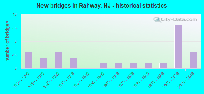
- New bridges - historical statistics
- 31900-1909
- 21910-1919
- 31920-1929
- 21930-1939
- 11950-1959
- 11960-1969
- 11970-1979
- 11980-1989
- 11990-1999
- 82000-2009
- 32010-2019


- Bridge Condition - Deck
- 5.9%Very good
- 47.1%Good
- 23.5%Satisfactory
- 23.5%Fair

- Bridge Condition - Superstructure
- 18.2%Very good
- 27.3%Good
- 18.2%Satisfactory
- 36.4%Fair

- Bridge Condition - Substructure
- 13.6%Very good
- 18.2%Good
- 50.0%Satisfactory
- 18.2%Fair

- Bridge Condition - Channel
- 9.1%Very good
- 36.4%Good
- 40.9%Satisfactory
- 13.6%Fair
Find on map >> Show street view
Structure Number: 200115, Location: 2.21 MI N OF 1+9-35 JCT (Lat: 40.598961, Lng: -74.271039), Route carried "on" structure: Ramp US 1, Year Built: 2009, Status: Open, Structure Length: 11.86m (38.91ft), Average Daily Traffic: 4,299 (year 2021), Truck Traffic: 4%, Average Future Daily Traffic: 5,246 (year 2041), Design Load: HL 93, Features Intersected: E HAZLEWOOD+RAHWAY RIVER
Minimum Vertical Clearance: 30+ m (98+ ft), Kilometerpoint: 62.443, Lanes on structure: 1, Lanes under structure: 2, Owner: State Highway Agency, Approaching Roadway Width: 7.9m (25.9ft), Navigation Control: Yes ( Vertical Clearance: 8.5m (27.9ft), Horizontal Clearance: 47.2m (154.9ft)), Material/Design: Steel continuous, Design/Construction: Stringer/Multi-beam, Number Of Spans In Main Unit: 3, Length of Maximum Span: 48.8m (160.1ft), Curb or Sidewalk Widths: Left: 1.8m (5.9ft), Right: 1.8m (5.9ft), Curb-To-Curb Width: 7.9m (25.9ft), Out-to-Out Width: 12.4m (40.7ft)
Condition: Deck: Good, Superstructure: Very good, Substructure: Very good, Channel: Satisfactory, Operating Rating: 58.6 metric tons, Method Used To Determine Operating Rating: Load and Resistance Factor Rating (LRFR) rating reported by rating factor(RF) method using HL-93 loadings, Inventory Rating: 45.0 metric tons, Method Used To Determine Inventory Rating: Load and Resistance Factor Rating (LRFR) rating reported by rating factor(RF) method using HL-93 loadings, Structural Evaluation: Equal to present desirable criteria, Deck Geometry: Equal to present desirable criteria, Underclear: Better than present minimum criteria, Waterway Adequacy: Equal to present desirable criteria, Approach Roadway Alignment: Equal to present minimum criteria, Designated Inspection Frequency: Every 24 months, Inspection Date: March 2021, Deck Structure Type: Concrete Cast-file-Place, Wearing Surface/Protective System: Deck Protection: Epoxy Coated Reinforcing
Find on map >> Show street view
Structure Number: 2001157, Location: 2.2 Mi N of 1+9 & 35 Jct. (Lat: 40.598819, Lng: -74.270469), Route carried "on" structure: US 1, Year Built: 2008, Status: Open, Structure Length: 32.58m (106.89ft), Average Daily Traffic: 69,274 (year 2020), Truck Traffic: 4%, Average Future Daily Traffic: 84,527 (year 2040), Design Load: HL 93, Features Intersected: RAHWYRV,CR514,CR621,RESR
Minimum Vertical Clearance: 30+ m (98+ ft), Kilometerpoint: 62.169, Lanes on structure: 6, Lanes under structure: 8, Base Highway Network: Yes, Owner: State Highway Agency, Approaching Roadway Width: 31.7m (104.0ft), Skew: 39 degrees, Navigation Control: Yes ( Vertical Clearance: 6.7m (22.0ft), Horizontal Clearance: 47.2m (154.9ft)), Material/Design: Steel continuous, Design/Construction: Stringer/Multi-beam, Number Of Spans In Main Unit: 7, Length of Maximum Span: 64.0m (210.0ft), Curb or Sidewalk Widths: Left: 1.8m (5.9ft), Right: 1.8m (5.9ft), Curb-To-Curb Width: 31.7m (104.0ft), Out-to-Out Width: 37.0m (121.4ft)
Condition: Deck: Good, Superstructure: Very good, Substructure: Good, Channel: Very good, Operating Rating: 50.5 metric tons, Method Used To Determine Operating Rating: Load and Resistance Factor Rating (LRFR) rating reported by rating factor(RF) method using HL-93 loadings, Inventory Rating: 38.9 metric tons, Method Used To Determine Inventory Rating: Load and Resistance Factor Rating (LRFR) rating reported by rating factor(RF) method using HL-93 loadings, Structural Evaluation: Better than present minimum criteria, Deck Geometry: Superior to present desirable criteria, Underclear: Meets minimum limits, Waterway Adequacy: Equal to present desirable criteria, Approach Roadway Alignment: Equal to present desirable criteria, Designated Inspection Frequency: Every 24 months, Inspection Date: March 2020, Deck Structure Type: Concrete Cast-file-Place, Wearing Surface/Protective System: Wearing Surface: Monolithic Concrete, Deck Protection: Epoxy Coated Reinforcing
Find on map >> Show street view
Structure Number: 2006152, Location: 2 MI NORTH OF 35 & 27 JCT (Lat: 40.618939, Lng: -74.282450), Route carried "on" structure: State highway 27, Year Built: 1914, Status: Open, Structure Length: 2.83m (9.28ft), Average Daily Traffic: 24,200 (year 2020), Truck Traffic: 4%, Average Future Daily Traffic: 29,500 (year 2040), Features Intersected: RAHWAY RIVER
Minimum Vertical Clearance: 30+ m (98+ ft), Kilometerpoint: 46.784, Lanes on structure: 4, Base Highway Network: Yes, Owner: State Highway Agency, Approaching Roadway Width: 20.1m (65.9ft), Skew: 3 degrees, Material/Design: Concrete, Design/Construction: Arch - Deck, Number Of Spans In Main Unit: 2, Length of Maximum Span: 13.1m (43.0ft), Curb or Sidewalk Widths: Left: 2.1m (6.9ft), Right: 2.1m (6.9ft), Curb-To-Curb Width: 20.1m (65.9ft), Out-to-Out Width: 25.0m (82.0ft)
Condition: Superstructure: Fair, Substructure: Fair, Channel: Fair, Structural Evaluation: Somewhat better than minimum adequacy, Deck Geometry: Better than present minimum criteria, Waterway Adequacy: Somewhat better than minimum adequacy, Approach Roadway Alignment: Better than present minimum criteria, Length Of Structure Improvement: 2.83m (9.28ft), Designated Inspection Frequency: Every 24 months, Inspection Date: March 2020, Bridge Improvement Cost: $614,000, Total Project Cost: $614,000 ( Estimate for 2020)
Find on map >> Show street view
Structure Number: 2013005, Location: 0.14 MI SW OF CR 613 (Lat: 40.609861, Lng: -74.275000), Route carried "on" structure: City street , Year Built: 1973, Status: Open, Structure Length: 3.11m (10.20ft), Average Daily Traffic: 9,098 (year 2020), Truck Traffic: 4%, Average Future Daily Traffic: 11,102 (year 2040), Design Load: HS 20, Features Intersected: RAHWAY RIVER, Facility Carried by Structure: ELIZABETH AVENUE
Minimum Vertical Clearance: 30+ m (98+ ft), Kilometerpoint: 0.145, Lanes on structure: 2, Owner: County Highway Agency, Approaching Roadway Width: 12.4m (40.7ft), Material/Design: Prestressed concrete, Design/Construction: Box Beam or Girders - Multiple, Number Of Spans In Main Unit: 2, Length of Maximum Span: 14.6m (47.9ft), Curb or Sidewalk Widths: Left: 3.3m (10.8ft), Right: 3.6m (11.8ft), Curb-To-Curb Width: 12.4m (40.7ft), Out-to-Out Width: 20.0m (65.6ft)
Condition: Deck: Fair, Superstructure: Satisfactory, Substructure: Satisfactory, Channel: Satisfactory, Operating Rating: 38.1 metric tons, Method Used To Determine Operating Rating: Load Factor (LF), Inventory Rating: 22.7 metric tons, Method Used To Determine Inventory Rating: Load Factor (LF), Structural Evaluation: Somewhat better than minimum adequacy, Deck Geometry: Somewhat better than minimum adequacy, Waterway Adequacy: Equal to present desirable criteria, Approach Roadway Alignment: Better than present minimum criteria, Designated Inspection Frequency: Every 24 months, Inspection Date: March 2020, Deck Structure Type: Concrete Cast-file-Place, Wearing Surface/Protective System: Wearing Surface: Monolithic Concrete
Find on map >> Show street view
Structure Number: 2013007, Location: 0.21 MI N OF CR 613 (Lat: 40.615900, Lng: -74.275539), Route carried "on" structure: City street , Year Built: 1925, Status: Open, Structure Length: 2.26m (7.41ft), Average Daily Traffic: 8,017 (year 2020), Truck Traffic: 3%, Average Future Daily Traffic: 9,782 (year 2040), Features Intersected: RAHWAY RIVER, Facility Carried by Structure: WHITTIER STREET
Minimum Vertical Clearance: 30+ m (98+ ft), Kilometerpoint: 0.338, Lanes on structure: 2, Owner: County Highway Agency, Approaching Roadway Width: 11.0m (36.1ft), Material/Design: Steel, Design/Construction: Stringer/Multi-beam, Number Of Spans In Main Unit: 2, Length of Maximum Span: 10.4m (34.1ft), Curb or Sidewalk Widths: Left: 2.3m (7.5ft), Right: 2.4m (7.9ft), Curb-To-Curb Width: 11.0m (36.1ft), Out-to-Out Width: 16.5m (54.1ft)
Condition: Deck: Fair, Superstructure: Fair, Substructure: Fair, Channel: Satisfactory, Operating Rating: 72.6 metric tons, Method Used To Determine Operating Rating: Load Factor (LF), Inventory Rating: 43.5 metric tons, Method Used To Determine Inventory Rating: Load Factor (LF), Structural Evaluation: Somewhat better than minimum adequacy, Deck Geometry: Meets minimum limits, Waterway Adequacy: Equal to present desirable criteria, Approach Roadway Alignment: Equal to present desirable criteria, Designated Inspection Frequency: Every 24 months, Inspection Date: March 2020, Deck Structure Type: Concrete Cast-file-Place, Wearing Surface/Protective System: Wearing Surface: Monolithic Concrete
Find on map >> Show street view
Structure Number: 2013008, Location: 0.58 MI N OF CR 602 (Lat: 40.608181, Lng: -74.290800), Route carried "on" structure: City street , Year Built: 2003, Status: Open, Structure Length: 1.92m (6.30ft), Average Daily Traffic: 9,690 (year 2020), Truck Traffic: 3%, Average Future Daily Traffic: 11,827 (year 2040), Design Load: HS 25 or greater, Features Intersected: ROBINSON BR OF RAHWAY RV, Facility Carried by Structure: JEFFERSON AVENUE
Minimum Vertical Clearance: 30+ m (98+ ft), Kilometerpoint: 1.545, Lanes on structure: 2, Owner: County Highway Agency, Approaching Roadway Width: 11.6m (38.1ft), Material/Design: Prestressed concrete, Design/Construction: Box Beam or Girders - Multiple, Number Of Spans In Main Unit: 2, Length of Maximum Span: 8.8m (28.9ft), Curb or Sidewalk Widths: Left: 1.5m (4.9ft), Right: 1.5m (4.9ft), Curb-To-Curb Width: 11.6m (38.1ft), Out-to-Out Width: 15.5m (50.9ft)
Condition: Deck: Good, Superstructure: Good, Substructure: Good, Channel: Satisfactory, Inventory Rating: 62.6 metric tons, Method Used To Determine Inventory Rating: Load Factor (LF), Structural Evaluation: Better than present minimum criteria, Deck Geometry: Somewhat better than minimum adequacy, Waterway Adequacy: Better than present minimum criteria, Approach Roadway Alignment: Equal to present desirable criteria, Designated Inspection Frequency: Every 24 months, Inspection Date: March 2020, Deck Structure Type: Concrete Cast-file-Place, Wearing Surface/Protective System: Wearing Surface: Epoxy Overlay, Deck Protection: Galvanized Reinforcing
Find on map >> Show street view
Structure Number: 2013009, Location: 0.22 MI NW OF US 1 & 9 (Lat: 40.600000, Lng: -74.274461), Route carried "on" structure: County highway 621, Year Built: 1921, Status: Open, Structure Length: 2.59m (8.50ft), Average Daily Traffic: 11,817 (year 2020), Truck Traffic: 3%, Average Future Daily Traffic: 14,180 (year 2040), Features Intersected: S. BR OF RAHWAY RIVER, Facility Carried by Structure: E. HAZELWOOD AVE
Minimum Vertical Clearance: 30+ m (98+ ft), Kilometerpoint: 1.400, Lanes on structure: 2, Owner: County Highway Agency, Approaching Roadway Width: 12.2m (40.0ft), Material/Design: Steel, Design/Construction: Stringer/Multi-beam, Number Of Spans In Main Unit: 2, Length of Maximum Span: 11.6m (38.1ft), Curb or Sidewalk Widths: Left: 2.7m (8.9ft), Right: 2.7m (8.9ft), Curb-To-Curb Width: 12.2m (40.0ft), Out-to-Out Width: 18.4m (60.4ft)
Condition: Deck: Satisfactory, Superstructure: Fair, Substructure: Fair, Channel: Very good, Operating Rating: 84.4 metric tons, Method Used To Determine Operating Rating: Load Factor (LF), Inventory Rating: 50.8 metric tons, Method Used To Determine Inventory Rating: Load Factor (LF), Structural Evaluation: Somewhat better than minimum adequacy, Deck Geometry: Somewhat better than minimum adequacy, Waterway Adequacy: Better than present minimum criteria, Approach Roadway Alignment: Equal to present desirable criteria, Length Of Structure Improvement: 9.75m (31.99ft), Designated Inspection Frequency: Every 24 months, Inspection Date: March 2020, Total Project Cost: $355,000 ( Estimate for 2020), Deck Structure Type: Concrete Cast-file-Place, Wearing Surface/Protective System: Wearing Surface: Bituminous
Find on map >> Show street view
Structure Number: 201301, Location: 0.13 MI S OF CR 613 (Lat: 40.611119, Lng: -74.276969), Route carried "on" structure: City street , Year Built: 1900, Status: Posted for load, Structure Length: 1.83m (6.00ft), Average Daily Traffic: 15,922 (year 2020), Truck Traffic: 3%, Average Future Daily Traffic: 18,730 (year 2040), Design Load: H 20, Features Intersected: ROBINSON BRANCH RAH RIV, Facility Carried by Structure: IRVING STREET
Minimum Vertical Clearance: 30+ m (98+ ft), Kilometerpoint: 0.209, Lanes on structure: 2, Owner: County Highway Agency, Approaching Roadway Width: 12.0m (39.4ft), Material/Design: Masonry, Design/Construction: Arch - Deck, Number Of Spans In Main Unit: 3, Length of Maximum Span: 5.5m (18.0ft), Curb or Sidewalk Widths: Left: 3.6m (11.8ft), Right: 3.6m (11.8ft), Curb-To-Curb Width: 12.0m (39.4ft), Out-to-Out Width: 20.1m (65.9ft)
Condition: Superstructure: Fair, Substructure: Fair, Channel: Satisfactory, Operating Rating: 46.3 metric tons, Method Used To Determine Operating Rating: Field evaluation and documented engineering judgment, Inventory Rating: 28.1 metric tons, Method Used To Determine Inventory Rating: Field evaluation and documented engineering judgment, Structural Evaluation: Somewhat better than minimum adequacy, Deck Geometry: Somewhat better than minimum adequacy, Waterway Adequacy: Superior to present desirable criteria, Approach Roadway Alignment: Equal to present desirable criteria, Designated Inspection Frequency: Every 24 months, Inspection Date: March 2020, Total Project Cost: $543,000 ( Estimate for 2020)
Find on map >> Show street view
Structure Number: 2013013, Location: NEAR MILL STREET (Lat: 40.595289, Lng: -74.282011), Route carried "on" structure: City street , Year Built: 2010, Status: Open, Structure Length: 1.68m (5.51ft), Average Daily Traffic: 5,962 (year 2020), Truck Traffic: 1%, Average Future Daily Traffic: 7,278 (year 2040), Design Load: HS 25 or greater, Features Intersected: SOUTH BR RAHWAY RIVER, Facility Carried by Structure: EAST INMAN AVENUE
Minimum Vertical Clearance: 30+ m (98+ ft), Kilometerpoint: 0.853, Lanes on structure: 2, Owner: County Highway Agency, Approaching Roadway Width: 12.2m (40.0ft), Material/Design: Prestressed concrete, Design/Construction: Box Beam or Girders - Multiple, Number Of Spans In Main Unit: 1, Length of Maximum Span: 14.9m (48.9ft), Curb or Sidewalk Widths: Left: 2.0m (6.6ft), Right: 2.0m (6.6ft), Curb-To-Curb Width: 12.2m (40.0ft), Out-to-Out Width: 17.1m (56.1ft)
Condition: Deck: Good, Superstructure: Good, Substructure: Good, Channel: Good, Inventory Rating: 60.8 metric tons, Method Used To Determine Inventory Rating: Load Factor (LF), Structural Evaluation: Better than present minimum criteria, Deck Geometry: Somewhat better than minimum adequacy, Waterway Adequacy: Better than present minimum criteria, Approach Roadway Alignment: Equal to present desirable criteria, Designated Inspection Frequency: Every 24 months, Inspection Date: April 2020, Deck Structure Type: Concrete Cast-file-Place, Wearing Surface/Protective System: Wearing Surface: Epoxy Overlay, Deck Protection: Galvanized Reinforcing
Find on map >> Show street view
Structure Number: 201302, Location: 0.05 MI W OF NJ 27 (Lat: 40.609681, Lng: -74.287650), Route carried "on" structure: City street , Year Built: 1921, Status: Open, Structure Length: 1.62m (5.31ft), Average Daily Traffic: 3,580 (year 2020), Truck Traffic: 1%, Average Future Daily Traffic: 4,366 (year 2040), Features Intersected: ROBINSONS BRANCH RAH RIV, Facility Carried by Structure: CENTRAL AVENUE
Minimum Vertical Clearance: 30+ m (98+ ft), Kilometerpoint: 0.000, Lanes on structure: 2, Owner: County Highway Agency, Approaching Roadway Width: 11.0m (36.1ft), Material/Design: Steel, Design/Construction: Stringer/Multi-beam, Number Of Spans In Main Unit: 2, Length of Maximum Span: 7.6m (24.9ft), Curb or Sidewalk Widths: Left: 2.8m (9.2ft), Right: 2.8m (9.2ft), Curb-To-Curb Width: 12.0m (39.4ft), Out-to-Out Width: 18.3m (60.0ft)
Condition: Deck: Fair, Superstructure: Fair, Substructure: Satisfactory, Channel: Good, Operating Rating: 52.6 metric tons, Method Used To Determine Operating Rating: Load Factor (LF), Inventory Rating: 31.8 metric tons, Method Used To Determine Inventory Rating: Load Factor (LF), Structural Evaluation: Somewhat better than minimum adequacy, Deck Geometry: Somewhat better than minimum adequacy, Waterway Adequacy: Better than present minimum criteria, Approach Roadway Alignment: Equal to present desirable criteria, Length Of Structure Improvement: 1.62m (5.31ft), Designated Inspection Frequency: Every 24 months, Inspection Date: March 2020, Total Project Cost: $482,000 ( Estimate for 2020), Deck Structure Type: Concrete Cast-file-Place, Wearing Surface/Protective System: Wearing Surface: Monolithic Concrete
Find on map >> Show street view
Structure Number: 2013021, Location: 0.15 MI W OF CR 514 (Lat: 40.604581, Lng: -74.271911), Route carried "on" structure: County highway 608, Year Built: 2002, Status: Open, Structure Length: 5.61m (18.41ft), Average Daily Traffic: 8,462 (year 2020), Truck Traffic: 3%, Average Future Daily Traffic: 10,154 (year 2040), Design Load: HS 20+Mod, Features Intersected: RAHWAY RIVER, Facility Carried by Structure: EAST MILTON AVENUE
Minimum Vertical Clearance: 30+ m (98+ ft), Kilometerpoint: 1.384, Lanes on structure: 2, Owner: County Highway Agency, Approaching Roadway Width: 11.0m (36.1ft), Material/Design: Prestressed concrete, Design/Construction: Box Beam or Girders - Multiple, Number Of Spans In Main Unit: 2, Length of Maximum Span: 27.1m (88.9ft), Curb or Sidewalk Widths: Left: 2.1m (6.9ft), Right: 2.1m (6.9ft), Curb-To-Curb Width: 11.0m (36.1ft), Out-to-Out Width: 15.9m (52.2ft)
Condition: Deck: Good, Superstructure: Good, Substructure: Satisfactory, Channel: Good, Operating Rating: 36.3 metric tons, Method Used To Determine Operating Rating: Load Factor (LF), Inventory Rating: 21.8 metric tons, Method Used To Determine Inventory Rating: Load Factor (LF), Structural Evaluation: Somewhat better than minimum adequacy, Deck Geometry: Meets minimum limits, Waterway Adequacy: Better than present minimum criteria, Approach Roadway Alignment: Better than present minimum criteria, Designated Inspection Frequency: Every 24 months, Inspection Date: March 2020, Deck Structure Type: Concrete Cast-file-Place, Wearing Surface/Protective System: Wearing Surface: Epoxy Overlay, Deck Protection: Bituminous
Find on map >> Show street view
Structure Number: 2013022, Location: 0.25 MI SW OF CR 613 (Lat: 40.611389, Lng: -74.282500), Route carried "on" structure: City street , Year Built: 1907, Status: Open, Structure Length: 1.86m (6.10ft), Average Daily Traffic: 1,443 (year 2020), Truck Traffic: 1%, Average Future Daily Traffic: 1,765 (year 2040), Features Intersected: ROBINSONS BRANCH RAH RIV, Facility Carried by Structure: NEW CHURCH STREET
Minimum Vertical Clearance: 30+ m (98+ ft), Kilometerpoint: 0.000, Lanes on structure: 2, Owner: County Highway Agency, Approaching Roadway Width: 9.1m (29.9ft), Skew: 1 degrees, Material/Design: Concrete, Design/Construction: Arch - Deck, Number Of Spans In Main Unit: 1, Length of Maximum Span: 18.6m (61.0ft), Curb or Sidewalk Widths: Left: 2.0m (6.6ft), Right: 2.0m (6.6ft), Curb-To-Curb Width: 9.1m (29.9ft), Out-to-Out Width: 14.0m (45.9ft)
Condition: Superstructure: Satisfactory, Substructure: Satisfactory, Channel: Satisfactory, Operating Rating: 38.1 metric tons, Method Used To Determine Operating Rating: Field evaluation and documented engineering judgment, Inventory Rating: 22.7 metric tons, Method Used To Determine Inventory Rating: Field evaluation and documented engineering judgment, Structural Evaluation: Equal to present minimum criteria, Deck Geometry: Somewhat better than minimum adequacy, Waterway Adequacy: Better than present minimum criteria, Approach Roadway Alignment: Equal to present desirable criteria, Designated Inspection Frequency: Every 24 months, Inspection Date: March 2020, Wearing Surface/Protective System: Wearing Surface: Bituminous
Find on map >> Show street view
Structure Number: 2013023, Location: 0.07 MILES WEST OF US 1 (Lat: 40.598850, Lng: -74.268750), Route carried "on" structure: County highway 514, Year Built: 1999, Status: Open, Structure Length: 8.02m (26.31ft), Average Daily Traffic: 11,246 (year 2020), Truck Traffic: 4%, Average Future Daily Traffic: 13,495 (year 2040), Design Load: HS 25 or greater, Features Intersected: RAHWAY RIVER
Minimum Vertical Clearance: 30+ m (98+ ft), Kilometerpoint: 61.445, Lanes on structure: 2, Owner: County Highway Agency, Approaching Roadway Width: 12.2m (40.0ft), Material/Design: Steel continuous, Design/Construction: Stringer/Multi-beam, Number Of Spans In Main Unit: 4, Length of Maximum Span: 19.5m (64.0ft), Curb or Sidewalk Widths: Left: 1.8m (5.9ft), Right: 1.8m (5.9ft), Curb-To-Curb Width: 12.2m (40.0ft), Out-to-Out Width: 16.5m (54.1ft)
Condition: Deck: Good, Superstructure: Good, Substructure: Satisfactory, Channel: Good, Operating Rating: 60.8 metric tons, Method Used To Determine Operating Rating: Load Factor (LF), Inventory Rating: 36.3 metric tons, Method Used To Determine Inventory Rating: Load Factor (LF), Structural Evaluation: Equal to present minimum criteria, Deck Geometry: Somewhat better than minimum adequacy, Waterway Adequacy: Equal to present desirable criteria, Approach Roadway Alignment: Equal to present desirable criteria, Designated Inspection Frequency: Every 24 months, Inspection Date: March 2020, Deck Structure Type: Concrete Cast-file-Place, Wearing Surface/Protective System: Wearing Surface: Monolithic Concrete, Deck Protection: Epoxy Coated Reinforcing
Find on map >> Show street view
Structure Number: 2013024, Location: 0.19 MI SW OF CR 514 (Lat: 40.607931, Lng: -74.273169), Route carried "on" structure: City street , Year Built: 2010, Status: Open, Structure Length: 3.35m (10.99ft), Average Daily Traffic: 4,870 (year 2020), Truck Traffic: 1%, Average Future Daily Traffic: 5,941 (year 2040), Design Load: HS 25 or greater, Features Intersected: Rahway River, Facility Carried by Structure: Monroe Street
Minimum Vertical Clearance: 30+ m (98+ ft), Kilometerpoint: 0.000, Lanes on structure: 2, Owner: County Highway Agency, Approaching Roadway Width: 11.0m (36.1ft), Material/Design: Steel continuous, Design/Construction: Stringer/Multi-beam, Number Of Spans In Main Unit: 2, Length of Maximum Span: 15.8m (51.8ft), Curb or Sidewalk Widths: Left: 3.1m (10.2ft), Right: 3.1m (10.2ft), Curb-To-Curb Width: 11.0m (36.1ft), Out-to-Out Width: 18.4m (60.4ft)
Condition: Deck: Good, Superstructure: Very good, Substructure: Very good, Channel: Good, Structural Evaluation: Equal to present desirable criteria, Deck Geometry: Somewhat better than minimum adequacy, Waterway Adequacy: Equal to present desirable criteria, Approach Roadway Alignment: Equal to present desirable criteria, Designated Inspection Frequency: Every 24 months, Inspection Date: April 2020, Deck Structure Type: Concrete Cast-file-Place, Wearing Surface/Protective System: Deck Protection: Galvanized Reinforcing
Find on map >> Show street view
Structure Number: 2013028, Location: 0.55 MI W OF CR 613 (Lat: 40.612211, Lng: -74.302819), Route carried "on" structure: County highway 604, Year Built: 2017, Status: Open, Structure Length: 1.74m (5.71ft), Average Daily Traffic: 8,266 (year 2020), Truck Traffic: 4%, Average Future Daily Traffic: 9,725 (year 2040), Design Load: HL 93, Features Intersected: ROBINSONS BR RAHWAY RIV, Facility Carried by Structure: MADISON HILL RD
Minimum Vertical Clearance: 30+ m (98+ ft), Kilometerpoint: 1.867, Lanes on structure: 2, Owner: County Highway Agency, Approaching Roadway Width: 12.7m (41.7ft), Material/Design: Prestressed concrete, Design/Construction: Box Beam or Girders - Multiple, Number Of Spans In Main Unit: 1, Length of Maximum Span: 16.2m (53.1ft), Curb or Sidewalk Widths: Left: 1.8m (5.9ft), Right: 1.8m (5.9ft), Curb-To-Curb Width: 12.7m (41.7ft), Out-to-Out Width: 17.5m (57.4ft)
Condition: Deck: Very good, Superstructure: Very good, Substructure: Very good, Channel: Satisfactory, Operating Rating: 92.0 metric tons, Method Used To Determine Operating Rating: Load and Resistance Factor Rating (LRFR) rating reported by rating factor(RF) method using HL-93 loadings, Inventory Rating: 60.3 metric tons, Method Used To Determine Inventory Rating: Load and Resistance Factor Rating (LRFR) rating reported by rating factor(RF) method using HL-93 loadings, Structural Evaluation: Equal to present desirable criteria, Deck Geometry: Somewhat better than minimum adequacy, Waterway Adequacy: Superior to present desirable criteria, Approach Roadway Alignment: Equal to present desirable criteria, Designated Inspection Frequency: Every 24 months, Inspection Date: March 2020, Deck Structure Type: Concrete Cast-file-Place, Wearing Surface/Protective System: Wearing Surface: Monolithic Concrete, Deck Protection: Galvanized Reinforcing
Find on map >> Show street view
Structure Number: 2013029, Location: 0.04 MI NW OF CENTRAL AVE (Lat: 40.610950, Lng: -74.277761), Route carried "on" structure: City street , Year Built: 1930, Status: Open, Structure Length: 2.04m (6.69ft), Average Daily Traffic: 2,601 (year 2020), Truck Traffic: 1%, Average Future Daily Traffic: 3,172 (year 2040), Features Intersected: ROBINSONS BRANCH RAH RIV, Facility Carried by Structure: HAMILTON STREET
Minimum Vertical Clearance: 30+ m (98+ ft), Kilometerpoint: 0.000, Lanes on structure: 2, Owner: County Highway Agency, Approaching Roadway Width: 12.3m (40.4ft), Skew: 2 degrees, Material/Design: Steel, Design/Construction: Stringer/Multi-beam, Number Of Spans In Main Unit: 2, Length of Maximum Span: 9.1m (29.9ft), Curb or Sidewalk Widths: Left: 3.5m (11.5ft), Right: 3.5m (11.5ft), Curb-To-Curb Width: 12.3m (40.4ft), Out-to-Out Width: 20.1m (65.9ft)
Condition: Deck: Satisfactory, Superstructure: Fair, Substructure: Satisfactory, Channel: Good, Operating Rating: 63.5 metric tons, Method Used To Determine Operating Rating: Load Factor (LF), Inventory Rating: 38.1 metric tons, Method Used To Determine Inventory Rating: Load Factor (LF), Structural Evaluation: Somewhat better than minimum adequacy, Deck Geometry: Equal to present minimum criteria, Waterway Adequacy: Superior to present desirable criteria, Approach Roadway Alignment: Equal to present desirable criteria, Length Of Structure Improvement: 1.58m (5.18ft), Designated Inspection Frequency: Every 24 months, Inspection Date: March 2020, Total Project Cost: $573,000 ( Estimate for 2020), Deck Structure Type: Concrete Cast-file-Place, Wearing Surface/Protective System: Wearing Surface: Monolithic Concrete
Find on map >> Show street view
Structure Number: 201303, Location: 0.05 MI W OF CR 514 (Lat: 40.611789, Lng: -74.274081), Route carried "on" structure: County highway 613, Year Built: 1917, Status: Open, Structure Length: 1.95m (6.40ft), Average Daily Traffic: 16,049 (year 2020), Truck Traffic: 4%, Average Future Daily Traffic: 19,258 (year 2040), Features Intersected: RAHWAY RIVER
Minimum Vertical Clearance: 30+ m (98+ ft), Kilometerpoint: 10.606, Lanes on structure: 2, Owner: County Highway Agency, Approaching Roadway Width: 12.0m (39.4ft), Material/Design: Concrete, Design/Construction: Arch - Deck, Number Of Spans In Main Unit: 1, Length of Maximum Span: 19.5m (64.0ft), Curb or Sidewalk Widths: Left: 2.7m (8.9ft), Right: 2.7m (8.9ft), Curb-To-Curb Width: 12.0m (39.4ft), Out-to-Out Width: 18.6m (61.0ft)
Condition: Superstructure: Fair, Substructure: Satisfactory, Channel: Fair, Operating Rating: 39.0 metric tons, Method Used To Determine Operating Rating: Field evaluation and documented engineering judgment, Inventory Rating: 23.6 metric tons, Method Used To Determine Inventory Rating: Field evaluation and documented engineering judgment, Structural Evaluation: Somewhat better than minimum adequacy, Deck Geometry: Somewhat better than minimum adequacy, Waterway Adequacy: Better than present minimum criteria, Approach Roadway Alignment: Equal to present minimum criteria, Designated Inspection Frequency: Every 24 months, Inspection Date: March 2020
Find on map >> Show street view
Structure Number: 201305, Location: 0.28 MI NE OF CR 613 (Lat: 40.617931, Lng: -74.278419), Route carried "on" structure: City street , Year Built: 1937, Status: Open, Structure Length: 2.53m (8.30ft), Average Daily Traffic: 1,520 (year 2020), Truck Traffic: 1%, Average Future Daily Traffic: 1,856 (year 2040), Features Intersected: RAHWAY RIVER, Facility Carried by Structure: CHURCH STREET
Minimum Vertical Clearance: 30+ m (98+ ft), Kilometerpoint: 0.000, Lanes on structure: 2, Owner: County Highway Agency, Approaching Roadway Width: 10.4m (34.1ft), Skew: 1 degrees, Material/Design: Steel, Design/Construction: Stringer/Multi-beam, Number Of Spans In Main Unit: 2, Length of Maximum Span: 11.6m (38.1ft), Curb or Sidewalk Widths: Left: 2.0m (6.6ft), Right: 2.0m (6.6ft), Curb-To-Curb Width: 10.4m (34.1ft), Out-to-Out Width: 15.1m (49.5ft)
Condition: Deck: Satisfactory, Superstructure: Satisfactory, Substructure: Satisfactory, Channel: Satisfactory, Inventory Rating: 70.8 metric tons, Method Used To Determine Inventory Rating: Load Factor (LF), Structural Evaluation: Equal to present minimum criteria, Deck Geometry: Equal to present minimum criteria, Waterway Adequacy: Better than present minimum criteria, Approach Roadway Alignment: Better than present minimum criteria, Designated Inspection Frequency: Every 24 months, Inspection Date: March 2020, Deck Structure Type: Concrete Cast-file-Place, Wearing Surface/Protective System: Wearing Surface: Monolithic Concrete
Find on map >> Show street view
Structure Number: 2013051, Location: 0.15 MI NORTH OF CR 613 (Lat: 40.615139, Lng: -74.276261), Route carried "on" structure: City street , Year Built: 1900, Status: Open, Structure Length: 0.70m (2.30ft), Average Daily Traffic: 8,011 (year 2020), Truck Traffic: 3%, Average Future Daily Traffic: 9,782 (year 2040), Design Load: H 20, Features Intersected: RAHWAY RIVER, Facility Carried by Structure: WHITTIER STREET
Minimum Vertical Clearance: 30+ m (98+ ft), Kilometerpoint: 0.225, Lanes on structure: 2, Owner: County Highway Agency, Approaching Roadway Width: 11.0m (36.1ft), Material/Design: Masonry, Design/Construction: Arch - Deck, Number Of Spans In Main Unit: 1, Length of Maximum Span: 7.0m (23.0ft), Curb or Sidewalk Widths: Left: 1.7m (5.6ft), Right: 2.0m (6.6ft), Curb-To-Curb Width: 11.0m (36.1ft), Out-to-Out Width: 18.4m (60.4ft)
Condition: Superstructure: Fair, Substructure: Satisfactory, Channel: Good, Operating Rating: 42.6 metric tons, Method Used To Determine Operating Rating: Field evaluation and documented engineering judgment, Inventory Rating: 25.4 metric tons, Method Used To Determine Inventory Rating: Field evaluation and documented engineering judgment, Structural Evaluation: Somewhat better than minimum adequacy, Deck Geometry: Meets minimum limits, Waterway Adequacy: Better than present minimum criteria, Approach Roadway Alignment: Equal to present desirable criteria, Designated Inspection Frequency: Every 24 months, Inspection Date: March 2020
Find on map >> Show street view
Structure Number: 2013058, Location: 0.26 MILES NORTH OF NJ 27 (Lat: 40.607281, Lng: -74.293789), Route carried "on" structure: City street , Year Built: 1958, Year Reconstructed: 1994, Status: Open, Structure Length: 2.13m (6.99ft), Average Daily Traffic: 14,790 (year 2020), Truck Traffic: 3%, Average Future Daily Traffic: 18,049 (year 2040), Design Load: HS 25 or greater, Features Intersected: ROBINSONS BRNCH RHWY RIV, Facility Carried by Structure: MAPLE AVENUE
Minimum Vertical Clearance: 30+ m (98+ ft), Kilometerpoint: 0.451, Lanes on structure: 2, Owner: County Highway Agency, Approaching Roadway Width: 13.3m (43.6ft), Skew: 3 degrees, Material/Design: Prestressed concrete, Design/Construction: Box Beam or Girders - Multiple, Number Of Spans In Main Unit: 1, Length of Maximum Span: 19.8m (65.0ft), Curb or Sidewalk Widths: Left: 1.8m (5.9ft), Right: 1.8m (5.9ft), Curb-To-Curb Width: 13.3m (43.6ft), Out-to-Out Width: 17.5m (57.4ft)
Condition: Deck: Good, Superstructure: Good, Substructure: Satisfactory, Channel: Satisfactory, Operating Rating: 83.5 metric tons, Method Used To Determine Operating Rating: Load Factor (LF), Inventory Rating: 49.9 metric tons, Method Used To Determine Inventory Rating: Load Factor (LF), Structural Evaluation: Equal to present minimum criteria, Deck Geometry: Somewhat better than minimum adequacy, Waterway Adequacy: Equal to present desirable criteria, Approach Roadway Alignment: Equal to present minimum criteria, Designated Inspection Frequency: Every 24 months, Inspection Date: March 2020, Deck Structure Type: Concrete Cast-file-Place, Wearing Surface/Protective System: Wearing Surface: Latex Concrete, Deck Protection: Epoxy Coated Reinforcing
Find on map >> Show street view
Structure Number: 2013064, Location: 0.05 MI NW OF NJ 27 (Lat: 40.598361, Lng: -74.291389), Route carried "on" structure: City street , Year Built: 1986, Status: Open, Structure Length: 0.73m (2.40ft), Average Daily Traffic: 510 (year 2020), Truck Traffic: 1%, Average Future Daily Traffic: 622 (year 2040), Design Load: HS 20+Mod, Features Intersected: STREAM 10-6-2, Facility Carried by Structure: PLAINFIELD AVENUE
Minimum Vertical Clearance: 30+ m (98+ ft), Kilometerpoint: 0.000, Lanes on structure: 2, Owner: County Highway Agency, Approaching Roadway Width: 11.0m (36.1ft), Skew: 2 degrees, Material/Design: Concrete, Design/Construction: Slab, Number Of Spans In Main Unit: 1, Length of Maximum Span: 7.3m (24.0ft), Curb or Sidewalk Widths: Left: 1.2m (3.9ft), Right: 3.3m (10.8ft), Curb-To-Curb Width: 11.0m (36.1ft), Out-to-Out Width: 16.2m (53.1ft)
Condition: Deck: Satisfactory, Superstructure: Good, Substructure: Good, Channel: Good, Operating Rating: 60.8 metric tons, Method Used To Determine Operating Rating: Load Factor (LF), Inventory Rating: 36.3 metric tons, Method Used To Determine Inventory Rating: Load Factor (LF), Structural Evaluation: Better than present minimum criteria, Deck Geometry: Better than present minimum criteria, Waterway Adequacy: Equal to present desirable criteria, Approach Roadway Alignment: Equal to present desirable criteria, Designated Inspection Frequency: Every 24 months, Inspection Date: March 2020, Deck Structure Type: Concrete Cast-file-Place, Wearing Surface/Protective System: Wearing Surface: Monolithic Concrete, Deck Protection: Epoxy Coated Reinforcing
Find on map >> Show street view
Structure Number: 202215, Location: 0.14 MI S OF RT 27 JCT (Lat: 40.592211, Lng: -74.290739), Route carried "on" structure: State highway 35, Year Built: 1968, Status: Open, Structure Length: 1.65m (5.41ft), Average Daily Traffic: 32,100 (year 2020), Truck Traffic: 4%, Average Future Daily Traffic: 38,500 (year 2040), Design Load: HS 20+Mod, Features Intersected: S BR RAHWAY RIVER
Minimum Vertical Clearance: 30+ m (98+ ft), Kilometerpoint: 93.245, Lanes on structure: 5, Base Highway Network: Yes, Owner: State Highway Agency, Approaching Roadway Width: 19.5m (64.0ft), Skew: 2 degrees, Material/Design: Prestressed concrete, Design/Construction: Box Beam or Girders - Multiple, Number Of Spans In Main Unit: 1, Length of Maximum Span: 15.8m (51.8ft), Curb or Sidewalk Widths: Left: 2.0m (6.6ft), Right: 1.8m (5.9ft), Curb-To-Curb Width: 19.3m (63.3ft), Out-to-Out Width: 23.9m (78.4ft)
Condition: Deck: Fair, Superstructure: Satisfactory, Substructure: Satisfactory, Channel: Fair, Operating Rating: 56.2 metric tons, Method Used To Determine Operating Rating: Load Factor (LF), Inventory Rating: 33.6 metric tons, Method Used To Determine Inventory Rating: Load Factor (LF), Structural Evaluation: Equal to present minimum criteria, Deck Geometry: Meets minimum limits, Waterway Adequacy: Equal to present minimum criteria, Approach Roadway Alignment: Equal to present desirable criteria, Designated Inspection Frequency: Every 24 months, Inspection Date: June 2020, Deck Structure Type: Concrete Cast-file-Place
Find on map >> Show street view
Structure Number: 200115, Location: 2.21 MI N OF 1+9-35 JCT (Lat: 40.598961, Lng: -74.271039), Route carried "under" structure: County highway 621, Year Built: 2009, Structure Length: 0. m, Average Daily Traffic: 8,417 (year 2021), Truck Traffic: 3%, Features Intersected: E HAZLEWOOD+RAHWAY RIVER, Facility Carried by Structure: US 1+9 RAMP C
Minimum Vertical Clearance: 4.85m (15.91ft), Kilometerpoint: 1.658, Lanes on structure: 1, Lanes under structure: 2, Material/Design: Steel continuous, Design/Construction: Stringer/Multi-beam, Length of Maximum Span: 48.8m (160.1ft)
Find on map >> Show street view
Structure Number: 2001157, Location: 2.2 Mi N of 1+9 & 35 Jct. (Lat: 40.598819, Lng: -74.270469), Route carried "under" structure: County highway 514, Year Built: 2008, Structure Length: 0. m, Average Daily Traffic: 10,053 (year 2020), Truck Traffic: 4%, Features Intersected: RAHWYRV,CR514,CR621,RESR, Facility Carried by Structure: US 1&9
Minimum Vertical Clearance: 5.46m (17.91ft), Kilometerpoint: 61.493, Lanes on structure: 6, Lanes under structure: 4, Material/Design: Steel continuous, Design/Construction: Stringer/Multi-beam, Length of Maximum Span: 64.0m (210.0ft)
Find on map >> Show street view
Structure Number: 2001157, Location: 2.2 Mi N of 1+9 & 35 Jct. (Lat: 40.598819, Lng: -74.270469), Route carried "under" structure: County highway 621, Year Built: 2008, Structure Length: 0. m, Average Daily Traffic: 13,814 (year 2020), Truck Traffic: 3%, Features Intersected: RAHWYRV,CR514,CR621,RESR, Facility Carried by Structure: US 1&9
Minimum Vertical Clearance: 4.95m (16.24ft), Kilometerpoint: 1.658, Lanes on structure: 6, Lanes under structure: 2, Material/Design: Steel continuous, Design/Construction: Stringer/Multi-beam, Length of Maximum Span: 64.0m (210.0ft)
Find on map >> Show street view
Structure Number: 2001157, Location: 2.2 Mi N of 1+9 & 35 Jct. (Lat: 40.598819, Lng: -74.270469), Route carried "under" structure: Other road , Year Built: 2008, Structure Length: 0. m, Average Daily Traffic: 114 (year 2020), Truck Traffic: 3%, Features Intersected: RAHWYRV,CR514,CR621,RESR, Facility Carried by Structure: US 1&9
Minimum Vertical Clearance: 4.72m (15.49ft), Kilometerpoint: 0.000, Lanes on structure: 6, Lanes under structure: 2, Material/Design: Steel continuous, Design/Construction: Stringer/Multi-beam, Length of Maximum Span: 64.0m (210.0ft)