Bridge Statistics for Progress, Pennsylvania (PA)
Condition, Traffic, Stress, Structural Evaluation, Project Costs
- National Bridge Inventory (NBI) Statistics
- 25Number of bridges
- 131ft / 40.0mTotal length
- $1,774,000Total costs
- 754,442Total average daily traffic
- 101,315Total average daily truck traffic
- National Bridge Inventory (NBI) Registered Bridges for Progress
- No street view available for this location
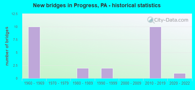
- New bridges - historical statistics
- 101960-1969
- 21980-1989
- 21990-1999
- 102010-2019
- 12020-2022


- Bridge Condition - Deck
- 9.1%Excellent
- 9.1%Very good
- 72.7%Good
- 9.1%Satisfactory

- Bridge Condition - Superstructure
- 9.1%Excellent
- 54.5%Very good
- 27.3%Good
- 9.1%Poor

- Bridge Condition - Substructure
- 9.1%Excellent
- 9.1%Very good
- 27.3%Good
- 54.5%Satisfactory

- Bridge Condition - Channel
- 33.3%Very good
- 66.7%Fair
Find on map >> Show street view
Structure Number: 14224, Location: 1.5 MI.N.OF PROGRESS (Lat: 40.301417, Lng: -76.857417), Route carried "on" structure: Interstate 81, Year Built: 1969, Year Reconstructed: 2003, Status: Open, Structure Length: 1.40m (4.59ft), Average Daily Traffic: 48,452 (year 2022), Truck Traffic: 18%, Average Future Daily Traffic: 57,541 (year 2032), Design Load: HS 20, Features Intersected: TWP RD 318; KOHN RD
Minimum Vertical Clearance: 30+ m (98+ ft), Kilometerpoint: 5.171, Lanes on structure: 3, Lanes under structure: 2, Base Highway Network: Yes, Owner: State Highway Agency, Approaching Roadway Width: 194.5m (638.1ft), Skew: 12 degrees, Material/Design: Prestressed concrete, Design/Construction: Box Beam or Girders - Single/Spread, Number Of Spans In Main Unit: 1, Length of Maximum Span: 12.8m (42.0ft), Curb or Sidewalk Widths: Left: 0.2m (0.7ft), Right: 0.2m (0.7ft), Curb-To-Curb Width: 19.4m (63.6ft), Out-to-Out Width: 20.3m (66.6ft)
Condition: Deck: Good, Superstructure: Very good, Substructure: Good, Operating Rating: 65.3 metric tons, Method Used To Determine Operating Rating: Load Factor (LF), Inventory Rating: 37.2 metric tons, Method Used To Determine Inventory Rating: Load Factor (LF), Structural Evaluation: Better than present minimum criteria, Deck Geometry: Superior to present desirable criteria, Underclear: Equal to present minimum criteria, Approach Roadway Alignment: Equal to present desirable criteria, Length Of Structure Improvement: 2.00m (6.56ft), Designated Inspection Frequency: Every 24 months, Inspection Date: October 2020, Deck Structure Type: Concrete Cast-file-Place, Wearing Surface/Protective System: Wearing Surface: Monolithic Concrete, Deck Protection: Epoxy Coated Reinforcing
Find on map >> Show street view
Structure Number: 14225, Location: 1.5 MI.N. PROGRESS (Lat: 40.301833, Lng: -76.857417), Route carried "on" structure: Interstate 81, Year Built: 1969, Status: Open, Structure Length: 1.25m (4.10ft), Average Daily Traffic: 45,355 (year 2022), Truck Traffic: 18%, Average Future Daily Traffic: 53,865 (year 2032), Design Load: HS 20, Features Intersected: TWP RD 318; KOHN RD
Minimum Vertical Clearance: 30+ m (98+ ft), Kilometerpoint: 5.150, Lanes on structure: 4, Lanes under structure: 2, Base Highway Network: Yes, Owner: State Highway Agency, Approaching Roadway Width: 18.9m (62.0ft), Skew: 10 degrees, Material/Design: Prestressed concrete, Design/Construction: Box Beam or Girders - Single/Spread, Number Of Spans In Main Unit: 1, Length of Maximum Span: 11.3m (37.1ft), Curb or Sidewalk Widths: Left: 0.2m (0.7ft), Right: 0.2m (0.7ft), Curb-To-Curb Width: 15.7m (51.5ft), Out-to-Out Width: 16.9m (55.4ft)
Condition: Deck: Good, Superstructure: Very good, Substructure: Satisfactory, Operating Rating: 70.8 metric tons, Method Used To Determine Operating Rating: Load Factor (LF), Inventory Rating: 43.5 metric tons, Method Used To Determine Inventory Rating: Load Factor (LF), Structural Evaluation: Equal to present minimum criteria, Deck Geometry: High priority of replacement, Underclear: High priority of corrective action, Approach Roadway Alignment: Equal to present desirable criteria, Length Of Structure Improvement: 1.90m (6.23ft), Designated Inspection Frequency: Every 24 months, Inspection Date: October 2020, Deck Structure Type: Concrete Cast-file-Place, Wearing Surface/Protective System: Wearing Surface: Latex Concrete
Find on map >> Show street view
Structure Number: 14226, Location: 1 MI.N.OF PROGRESS (Lat: 40.303278, Lng: -76.850017), Route carried "on" structure: Interstate 81, Year Built: 1969, Year Reconstructed: 2003, Status: Open, Structure Length: 5.64m (18.50ft), Average Daily Traffic: 54,013 (year 2022), Truck Traffic: 18%, Average Future Daily Traffic: 64,147 (year 2032), Design Load: HS 20, Features Intersected: SR 3015
Minimum Vertical Clearance: 30+ m (98+ ft), Kilometerpoint: 5.971, Lanes on structure: 4, Lanes under structure: 8, Base Highway Network: Yes, Owner: State Highway Agency, Approaching Roadway Width: 24.4m (80.1ft), Skew: 10 degrees, Material/Design: Prestressed concrete, Design/Construction: Box Beam or Girders - Single/Spread, Number Of Spans In Main Unit: 4, Length of Maximum Span: 18.3m (60.0ft), Curb or Sidewalk Widths: Left: 0.2m (0.7ft), Right: 0.2m (0.7ft), Curb-To-Curb Width: 22.3m (73.2ft), Out-to-Out Width: 24.1m (79.1ft)
Condition: Deck: Good, Superstructure: Good, Substructure: Satisfactory, Operating Rating: 64.4 metric tons, Method Used To Determine Operating Rating: Load Factor (LF), Inventory Rating: 38.1 metric tons, Method Used To Determine Inventory Rating: Load Factor (LF), Structural Evaluation: Equal to present minimum criteria, Deck Geometry: Superior to present desirable criteria, Underclear: Somewhat better than minimum adequacy, Approach Roadway Alignment: Equal to present desirable criteria, Length Of Structure Improvement: 6.60m (21.65ft), Designated Inspection Frequency: Every 24 months, Inspection Date: December 2020, Bridge Improvement Cost: $102,000, Roadway Improvement Cost: $299,000, Total Project Cost: $1,371,000, Deck Structure Type: Concrete Cast-file-Place, Wearing Surface/Protective System: Wearing Surface: Monolithic Concrete, Deck Protection: Epoxy Coated Reinforcing
Find on map >> Show street view
Structure Number: 14227, Location: 1 MI. N. PROGRESS (Lat: 40.303778, Lng: -76.850122), Route carried "on" structure: Interstate 81, Year Built: 1969, Year Reconstructed: 2003, Status: Open, Structure Length: 5.64m (18.50ft), Average Daily Traffic: 51,690 (year 2022), Truck Traffic: 19%, Average Future Daily Traffic: 61,389 (year 2032), Design Load: HS 20, Features Intersected: SR 3015
Minimum Vertical Clearance: 30+ m (98+ ft), Kilometerpoint: 5.932, Lanes on structure: 4, Lanes under structure: 10, Base Highway Network: Yes, Owner: State Highway Agency, Approaching Roadway Width: 18.9m (62.0ft), Skew: 10 degrees, Material/Design: Prestressed concrete, Design/Construction: Box Beam or Girders - Single/Spread, Number Of Spans In Main Unit: 4, Length of Maximum Span: 18.0m (59.1ft), Curb or Sidewalk Widths: Left: 0.2m (0.7ft), Right: 0.2m (0.7ft), Curb-To-Curb Width: 19.4m (63.6ft), Out-to-Out Width: 20.1m (65.9ft)
Condition: Deck: Good, Superstructure: Good, Substructure: Satisfactory, Operating Rating: 66.2 metric tons, Method Used To Determine Operating Rating: Load Factor (LF), Inventory Rating: 35.4 metric tons, Method Used To Determine Inventory Rating: Load Factor (LF), Structural Evaluation: Equal to present minimum criteria, Deck Geometry: Somewhat better than minimum adequacy, Underclear: Superior to present desirable criteria, Approach Roadway Alignment: Equal to present desirable criteria, Length Of Structure Improvement: 6.60m (21.65ft), Designated Inspection Frequency: Every 24 months, Inspection Date: October 2020, Bridge Improvement Cost: $30,000, Roadway Improvement Cost: $88,000, Total Project Cost: $403,000, Deck Structure Type: Concrete Cast-file-Place, Wearing Surface/Protective System: Wearing Surface: Monolithic Concrete, Deck Protection: Epoxy Coated Reinforcing
Find on map >> Show street view
Structure Number: 14281, Location: S. OF UNION DEPOSIT (Lat: 40.272442, Lng: -76.816019), Route carried "on" structure: Interstate 83, Year Built: 1994, Status: Open, Structure Length: 1.86m (6.10ft), Average Daily Traffic: 124,398 (year 2022), Truck Traffic: 10%, Average Future Daily Traffic: 147,737 (year 2032), Design Load: HS 20, Features Intersected: TWP RD 392,PEIFFER LANE
Minimum Vertical Clearance: 30+ m (98+ ft), Kilometerpoint: 8.839, Lanes on structure: 6, Lanes under structure: 2, Base Highway Network: Yes, Owner: State Highway Agency, Approaching Roadway Width: 30.5m (100.1ft), Skew: 32 degrees, Material/Design: Prestressed concrete, Design/Construction: Box Beam or Girders - Single/Spread, Number Of Spans In Main Unit: 1, Length of Maximum Span: 18.0m (59.1ft), Curb or Sidewalk Widths: Left: 0.2m (0.7ft), Right: 0.2m (0.7ft), Curb-To-Curb Width: 37.5m (123.0ft), Out-to-Out Width: 39.5m (129.6ft)
Condition: Deck: Good, Superstructure: Very good, Substructure: Satisfactory, Operating Rating: 75.3 metric tons, Method Used To Determine Operating Rating: Load Factor (LF), Inventory Rating: 43.5 metric tons, Method Used To Determine Inventory Rating: Load Factor (LF), Structural Evaluation: Equal to present minimum criteria, Deck Geometry: Superior to present desirable criteria, Underclear: Equal to present minimum criteria, Approach Roadway Alignment: Equal to present desirable criteria, Length Of Structure Improvement: 2.50m (8.20ft), Designated Inspection Frequency: Every 24 months, Inspection Date: November 2020, Deck Structure Type: Concrete Cast-file-Place, Wearing Surface/Protective System: Wearing Surface: Monolithic Concrete, Deck Protection: Epoxy Coated Reinforcing
Find on map >> Show street view
Structure Number: 14628, Location: WITF STUDIO PAXTON CRK (Lat: 40.289614, Lng: -76.861406), Route carried "on" structure: City street , Year Built: 1987, Status: Open, Structure Length: 1.34m (4.40ft), Average Daily Traffic: 750 (year 2019), Truck Traffic: 1%, Average Future Daily Traffic: 175 (year 2039), Design Load: HS 20, Features Intersected: TRIB TO PAXTON CREEK, Facility Carried by Structure: STATE FARM RD T318
Minimum Vertical Clearance: 30+ m (98+ ft), Kilometerpoint: 0.000, Lanes on structure: 2, Owner: Town or Township Highway Agency, Approaching Roadway Width: 9.8m (32.2ft), Skew: 6 degrees, Material/Design: Concrete, Design/Construction: Slab, Number Of Spans In Main Unit: 1, Length of Maximum Span: 12.8m (42.0ft), Curb or Sidewalk Widths: Left: 0.2m (0.7ft), Right: 0.2m (0.7ft), Curb-To-Curb Width: 9.6m (31.5ft), Out-to-Out Width: 10.7m (35.1ft)
Condition: Deck: Good, Superstructure: Good, Substructure: Satisfactory, Channel: Fair, Operating Rating: 73.5 metric tons, Method Used To Determine Operating Rating: Load Factor (LF), Inventory Rating: 43.5 metric tons, Method Used To Determine Inventory Rating: Load Factor (LF), Structural Evaluation: Equal to present minimum criteria, Deck Geometry: Equal to present minimum criteria, Waterway Adequacy: Better than present minimum criteria, Approach Roadway Alignment: Somewhat better than minimum adequacy, Length Of Structure Improvement: 1.70m (5.58ft), Designated Inspection Frequency: Every 24 months, Inspection Date: May 2021, Deck Structure Type: Concrete Cast-file-Place, Wearing Surface/Protective System: Wearing Surface: Monolithic Concrete, Deck Protection: Epoxy Coated Reinforcing
Find on map >> Show street view
Structure Number: 14631, Location: .6 NW 81 &PROG.AVE PXTCRK (Lat: 40.306072, Lng: -76.855614), Route carried "on" structure: City street , Year Built: 1987, Status: Open, Structure Length: 1.58m (5.18ft), Average Daily Traffic: 450 (year 2021), Truck Traffic: 4%, Average Future Daily Traffic: 490 (year 2041), Features Intersected: PAXTON CREEK, Facility Carried by Structure: KOHN ROAD, T-431
Minimum Vertical Clearance: 30+ m (98+ ft), Kilometerpoint: 0.000, Lanes on structure: 2, Owner: Town or Township Highway Agency, Approaching Roadway Width: 9.8m (32.2ft), Skew: 3 degrees, Material/Design: Prestressed concrete, Design/Construction: Box Beam or Girders - Single/Spread, Number Of Spans In Main Unit: 1, Length of Maximum Span: 15.2m (49.9ft), Curb or Sidewalk Widths: Left: 0.2m (0.7ft), Right: 0.2m (0.7ft), Curb-To-Curb Width: 9.8m (32.2ft), Out-to-Out Width: 10.8m (35.4ft)
Condition: Deck: Satisfactory, Superstructure: Poor, Substructure: Satisfactory, Channel: Fair, Operating Rating: 52.6 metric tons, Method Used To Determine Operating Rating: Load Factor (LF), Inventory Rating: 31.8 metric tons, Method Used To Determine Inventory Rating: Load Factor (LF), Structural Evaluation: Meets minimum limits, Deck Geometry: Equal to present minimum criteria, Waterway Adequacy: Superior to present desirable criteria, Approach Roadway Alignment: Equal to present desirable criteria, Length Of Structure Improvement: 2.20m (7.22ft), Designated Inspection Frequency: Every 24 months, Other Special Inspection Frequency: Every 12 months, Inspection Date: May 2021, Other Special Inspection Date: May 2021, Deck Structure Type: Concrete Cast-file-Place, Wearing Surface/Protective System: Wearing Surface: Monolithic Concrete, Deck Protection: Epoxy Coated Reinforcing
Find on map >> Show street view
Structure Number: 48278, Location: 0.3 Mi Ea I-83 Slotznick (Lat: 40.282136, Lng: -76.825908), Route carried "on" structure: City street , Year Built: 2013, Status: Open, Structure Length: 0.67m (2.20ft), Average Daily Traffic: 3,547 (year 2019), Truck Traffic: 3%, Average Future Daily Traffic: 4,119 (year 2039), Design Load: HL 93, Features Intersected: Slotznick Run, Facility Carried by Structure: Schoolhouse Lane
Minimum Vertical Clearance: 30+ m (98+ ft), Kilometerpoint: 0.000, Lanes on structure: 2, Toll: Toll bridge, Owner: Town or Township Highway Agency, Approaching Roadway Width: 9.1m (29.9ft), Skew: 1 degrees, Material/Design: Concrete, Design/Construction: Culvert, Number Of Spans In Main Unit: 1, Length of Maximum Span: 6.1m (20.0ft), Curb or Sidewalk Widths: Left: 1.7m (5.6ft), Right: 2.0m (6.6ft), Curb-To-Curb Width: 9.1m (29.9ft), Out-to-Out Width: 14.0m (45.9ft)
Condition: Channel: Very good, Culverts: Good, Operating Rating: 61.9 metric tons, Method Used To Determine Operating Rating: Assigned ratings based on Load and Resistance Factor Design (LRFD) reported by rating factor (RF) using HL93 loadings, Inventory Rating: 47.6 metric tons, Method Used To Determine Inventory Rating: Assigned ratings based on Load and Resistance Factor Design (LRFD) reported by rating factor (RF) using HL93 loadings, Structural Evaluation: Better than present minimum criteria, Deck Geometry: Meets minimum limits, Waterway Adequacy: Equal to present desirable criteria, Approach Roadway Alignment: Equal to present desirable criteria, Designated Inspection Frequency: Every 24 months, Inspection Date: May 2021
Find on map >> Show street view
Structure Number: 53649, Location: 0.2 Mi N of Ex 50 (US-22) (Lat: 40.298878, Lng: -76.826608), Route carried "on" structure: State highway , Year Built: 2016, Status: Open, Structure Length: 5.12m (16.80ft), Average Daily Traffic: 3,917 (year 2021), Truck Traffic: 2%, Average Future Daily Traffic: 5,291 (year 2032), Design Load: HL 93, Features Intersected: I-83; SR 0083 NB/SB, Facility Carried by Structure: SR3026;Elmerton Av
Minimum Vertical Clearance: 30+ m (98+ ft), Kilometerpoint: 4.701, Lanes on structure: 2, Lanes under structure: 8, Owner: State Highway Agency, Approaching Roadway Width: 11.6m (38.1ft), Skew: 1 degrees, Material/Design: Prestressed concrete continuous, Design/Construction: Box Beam or Girders - Single/Spread, Number Of Spans In Main Unit: 2, Length of Maximum Span: 26.2m (86.0ft), Curb or Sidewalk Widths: Left: 0.2m (0.7ft), Right: 0.2m (0.7ft), Curb-To-Curb Width: 11.6m (38.1ft), Out-to-Out Width: 12.7m (41.7ft)
Condition: Deck: Very good, Superstructure: Very good, Substructure: Very good, Operating Rating: 49.2 metric tons, Method Used To Determine Operating Rating: Assigned ratings based on Load and Resistance Factor Design (LRFD) reported by rating factor (RF) using HL93 loadings, Inventory Rating: 37.9 metric tons, Method Used To Determine Inventory Rating: Assigned ratings based on Load and Resistance Factor Design (LRFD) reported by rating factor (RF) using HL93 loadings, Structural Evaluation: Equal to present desirable criteria, Deck Geometry: Somewhat better than minimum adequacy, Underclear: Equal to present minimum criteria, Approach Roadway Alignment: Better than present minimum criteria, Designated Inspection Frequency: Every 24 months, Inspection Date: December 2020, Deck Structure Type: Concrete Cast-file-Place, Wearing Surface/Protective System: Wearing Surface: Monolithic Concrete, Deck Protection: Epoxy Coated Reinforcing
Find on map >> Show street view
Structure Number: 54636, Location: 1.5MI E OF HARRISBURG (Lat: 40.278736, Lng: -76.818961), Route carried "on" structure: State highway , Year Built: 2017, Status: Open, Structure Length: 4.66m (15.29ft), Average Daily Traffic: 32,144 (year 2022), Truck Traffic: 2%, Average Future Daily Traffic: 37,805 (year 2032), Design Load: HL 93, Features Intersected: I 83; SR 0083, Facility Carried by Structure: SR 3020
Minimum Vertical Clearance: 30+ m (98+ ft), Kilometerpoint: 3.199, Lanes on structure: 6, Lanes under structure: 6, Owner: State Highway Agency, Approaching Roadway Width: 29.3m (96.1ft), Skew: 1 degrees, Material/Design: Prestressed concrete continuous, Design/Construction: Stringer/Multi-beam, Number Of Spans In Main Unit: 2, Length of Maximum Span: 23.2m (76.1ft), Curb or Sidewalk Widths: Left: 2.5m (8.2ft), Right: 2.5m (8.2ft), Curb-To-Curb Width: 29.3m (96.1ft), Out-to-Out Width: 35.0m (114.8ft)
Condition: Deck: Good, Superstructure: Very good, Substructure: Good, Operating Rating: 42.8 metric tons, Method Used To Determine Operating Rating: Assigned ratings based on Load and Resistance Factor Design (LRFD) reported by rating factor (RF) using HL93 loadings, Inventory Rating: 33.4 metric tons, Method Used To Determine Inventory Rating: Assigned ratings based on Load and Resistance Factor Design (LRFD) reported by rating factor (RF) using HL93 loadings, Structural Evaluation: Better than present minimum criteria, Deck Geometry: Superior to present desirable criteria, Underclear: Equal to present minimum criteria, Approach Roadway Alignment: Equal to present desirable criteria, Designated Inspection Frequency: Every 24 months, Inspection Date: December 2020, Deck Structure Type: Concrete Cast-file-Place, Wearing Surface/Protective System: Wearing Surface: Latex Concrete, Deck Protection: Epoxy Coated Reinforcing
Find on map >> Show street view
Structure Number: 56025, Location: COLONIAL PARK (Lat: 40.296389, Lng: -76.825472), Route carried "on" structure: US 22, Year Built: 2018, Status: Open, Structure Length: 4.91m (16.11ft), Average Daily Traffic: 28,921 (year 2022), Truck Traffic: 3%, Average Future Daily Traffic: 31,398 (year 2039), Design Load: HL 93, Features Intersected: I-83; SR 0083
Minimum Vertical Clearance: 30+ m (98+ ft), Kilometerpoint: 29.749, Lanes on structure: 5, Lanes under structure: 4, Base Highway Network: Yes, Owner: State Highway Agency, Approaching Roadway Width: 14.3m (46.9ft), Skew: 2 degrees, Material/Design: Prestressed concrete continuous, Design/Construction: Stringer/Multi-beam, Number Of Spans In Main Unit: 2, Length of Maximum Span: 25.9m (85.0ft), Curb or Sidewalk Widths: Left: 1.6m (5.2ft), Right: 1.6m (5.2ft), Curb-To-Curb Width: 14.5m (47.6ft), Out-to-Out Width: 34.6m (113.5ft)
Condition: Deck: Good, Superstructure: Very good, Substructure: Good, Operating Rating: 47.3 metric tons, Method Used To Determine Operating Rating: Assigned ratings based on Load and Resistance Factor Design (LRFD) reported by rating factor (RF) using HL93 loadings, Inventory Rating: 36.6 metric tons, Method Used To Determine Inventory Rating: Assigned ratings based on Load and Resistance Factor Design (LRFD) reported by rating factor (RF) using HL93 loadings, Structural Evaluation: Better than present minimum criteria, Deck Geometry: High priority of replacement, Underclear: Equal to present minimum criteria, Approach Roadway Alignment: Equal to present desirable criteria, Designated Inspection Frequency: Every 24 months, Inspection Date: November 2020, Deck Structure Type: Concrete Precast Panels, Wearing Surface/Protective System: Wearing Surface: Latex Concrete, Deck Protection: Epoxy Coated Reinforcing
Find on map >> Show street view
Structure Number: 67835, Location: 1 MI.N.E. OF PROGRESS (Lat: 40.303950, Lng: -76.830222), Route carried "on" structure: Interstate 83, Year Built: 2020, Status: Open, Structure Length: 5.91m (19.39ft), Average Daily Traffic: 38,711 (year 2022), Truck Traffic: 18%, Average Future Daily Traffic: 49,799 (year 2032), Design Load: HL 93, Features Intersected: T-431, Valley Road
Minimum Vertical Clearance: 30+ m (98+ ft), Kilometerpoint: 11.962, Lanes on structure: 4, Lanes under structure: 2, Base Highway Network: Yes, Owner: State Highway Agency, Approaching Roadway Width: 25.0m (82.0ft), Skew: 13 degrees, Material/Design: Prestressed concrete, Design/Construction: Stringer/Multi-beam, Number Of Spans In Main Unit: 1, Length of Maximum Span: 42.7m (140.1ft), Curb or Sidewalk Widths: Left: 0.1m (0.3ft), Right: 0.1m (0.3ft), Curb-To-Curb Width: 24.1m (79.1ft), Out-to-Out Width: 25.1m (82.3ft)
Condition: Deck: Excellent, Superstructure: Excellent, Substructure: Excellent, Operating Rating: 56.1 metric tons, Method Used To Determine Operating Rating: Assigned ratings based on Load and Resistance Factor Design (LRFD) reported by rating factor (RF) using HL93 loadings, Inventory Rating: 40.2 metric tons, Method Used To Determine Inventory Rating: Assigned ratings based on Load and Resistance Factor Design (LRFD) reported by rating factor (RF) using HL93 loadings, Structural Evaluation: Superior to present desirable criteria, Deck Geometry: Superior to present desirable criteria, Underclear: Superior to present desirable criteria, Approach Roadway Alignment: Better than present minimum criteria, Designated Inspection Frequency: Every 24 months, Inspection Date: November 2020, Deck Structure Type: Concrete Cast-file-Place, Wearing Surface/Protective System: Wearing Surface: Monolithic Concrete, Deck Protection: Epoxy Coated Reinforcing
Find on map >> Show street view
Structure Number: 14224, Location: 1.5 MI.N.OF PROGRESS (Lat: 40.301417, Lng: -76.857417), Route carried "under" structure: City street , Year Built: 1969, Structure Length: 0. m, Average Daily Traffic: 1 (year 2005), Features Intersected: TWP RD 318; KOHN RD, Facility Carried by Structure: I-81 NB; SR 0081
Minimum Vertical Clearance: 4.65m (15.26ft), Kilometerpoint: 0.000, Lanes on structure: 3, Lanes under structure: 2, Material/Design: Prestressed concrete, Design/Construction: Box Beam or Girders - Single/Spread, Length of Maximum Span: 12.8m (42.0ft)
Find on map >> Show street view
Structure Number: 14225, Location: 1.5 MI.N. PROGRESS (Lat: 40.301833, Lng: -76.857417), Route carried "under" structure: City street , Year Built: 1969, Structure Length: 0. m, Average Daily Traffic: 28,443 (year 1988), Features Intersected: TWP RD 318; KOHN RD, Facility Carried by Structure: I-81 SB; SR 0081
Minimum Vertical Clearance: 4.50m (14.76ft), Kilometerpoint: 0.000, Lanes on structure: 4, Lanes under structure: 2, Material/Design: Prestressed concrete, Design/Construction: Box Beam or Girders - Single/Spread, Length of Maximum Span: 11.3m (37.1ft)
Find on map >> Show street view
Structure Number: 14226, Location: 1 MI.N.OF PROGRESS (Lat: 40.303278, Lng: -76.850017), Route carried "under" structure: State highway , Year Built: 1969, Structure Length: 0. m, Average Daily Traffic: 6,368 (year 2022), Truck Traffic: 3%, Features Intersected: SR 3015, Facility Carried by Structure: I-81 NB; SR 0081
Minimum Vertical Clearance: 5.38m (17.65ft), Kilometerpoint: 4.939, Lanes on structure: 4, Lanes under structure: 4, Material/Design: Prestressed concrete, Design/Construction: Box Beam or Girders - Single/Spread, Length of Maximum Span: 18.3m (60.0ft)
Find on map >> Show street view
Structure Number: 14226, Location: 1 MI.N.OF PROGRESS (Lat: 40.303278, Lng: -76.850017), Route carried "under" structure: State highway , Year Built: 1969, Structure Length: 0. m, Average Daily Traffic: 6,368 (year 2022), Truck Traffic: 3%, Features Intersected: SR 3015, Facility Carried by Structure: I-81 NB; SR 0081
Minimum Vertical Clearance: 5.31m (17.42ft), Kilometerpoint: 4.939, Lanes on structure: 4, Lanes under structure: 4, Material/Design: Prestressed concrete, Design/Construction: Box Beam or Girders - Single/Spread, Length of Maximum Span: 18.3m (60.0ft)
Find on map >> Show street view
Structure Number: 14227, Location: 1 MI. N. PROGRESS (Lat: 40.303778, Lng: -76.850122), Route carried "under" structure: State highway , Year Built: 1969, Structure Length: 0. m, Average Daily Traffic: 6,368 (year 2022), Truck Traffic: 3%, Features Intersected: SR 3015, Facility Carried by Structure: I-81 SB; SR 0081
Minimum Vertical Clearance: 5.46m (17.91ft), Kilometerpoint: 4.939, Lanes on structure: 4, Lanes under structure: 5, Material/Design: Prestressed concrete, Design/Construction: Box Beam or Girders - Single/Spread, Length of Maximum Span: 18.0m (59.1ft)
Find on map >> Show street view
Structure Number: 14227, Location: 1 MI. N. PROGRESS (Lat: 40.303778, Lng: -76.850122), Route carried "under" structure: State highway , Year Built: 1969, Structure Length: 0. m, Average Daily Traffic: 6,368 (year 2022), Truck Traffic: 3%, Features Intersected: SR 3015, Facility Carried by Structure: I-81 SB; SR 0081
Minimum Vertical Clearance: 5.39m (17.68ft), Kilometerpoint: 4.939, Lanes on structure: 4, Lanes under structure: 5, Material/Design: Prestressed concrete, Design/Construction: Box Beam or Girders - Single/Spread, Length of Maximum Span: 18.0m (59.1ft)
Find on map >> Show street view
Structure Number: 14281, Location: S. OF UNION DEPOSIT (Lat: 40.272442, Lng: -76.816019), Route carried "under" structure: City street , Year Built: 1994, Structure Length: 0. m, Average Daily Traffic: 1 (year 2005), Features Intersected: TWP RD 392,PEIFFER LANE, Facility Carried by Structure: I-83; SR 0083
Minimum Vertical Clearance: 4.45m (14.60ft), Kilometerpoint: 0.000, Lanes on structure: 6, Lanes under structure: 2, Material/Design: Prestressed concrete, Design/Construction: Box Beam or Girders - Single/Spread, Length of Maximum Span: 18.0m (59.1ft)
Find on map >> Show street view
Structure Number: 53649, Location: 0.2 Mi N of Ex 50 (US-22) (Lat: 40.298878, Lng: -76.826608), Route carried "under" structure: Interstate 83, Year Built: 2016, Structure Length: 0. m, Average Daily Traffic: 38,711 (year 2022), Truck Traffic: 18%, Features Intersected: I-83; SR 0083 NB/SB, Facility Carried by Structure: SR3026;Elmerton Av
Minimum Vertical Clearance: 5.52m (18.11ft), Kilometerpoint: 11.141, Lanes on structure: 2, Lanes under structure: 4, Material/Design: Prestressed concrete continuous, Design/Construction: Box Beam or Girders - Single/Spread, Length of Maximum Span: 26.2m (86.0ft)
Find on map >> Show street view
Structure Number: 53649, Location: 0.2 Mi N of Ex 50 (US-22) (Lat: 40.298878, Lng: -76.826608), Route carried "under" structure: Interstate 83, Year Built: 2016, Structure Length: 0. m, Average Daily Traffic: 47,691 (year 2022), Truck Traffic: 16%, Features Intersected: I-83; SR 0083 NB/SB, Facility Carried by Structure: SR3026;Elmerton Av
Minimum Vertical Clearance: 5.52m (18.11ft), Kilometerpoint: 11.188, Lanes on structure: 2, Lanes under structure: 4, Material/Design: Prestressed concrete continuous, Design/Construction: Box Beam or Girders - Single/Spread, Length of Maximum Span: 26.2m (86.0ft)
Find on map >> Show street view
Structure Number: 54636, Location: 1.5MI E OF HARRISBURG (Lat: 40.278736, Lng: -76.818961), Route carried "under" structure: Interstate 83, Year Built: 2017, Structure Length: 0. m, Average Daily Traffic: 49,958 (year 2022), Truck Traffic: 14%, Features Intersected: I 83; SR 0083, Facility Carried by Structure: SR 3020
Minimum Vertical Clearance: 5.13m (16.83ft), Kilometerpoint: 8.795, Lanes on structure: 6, Lanes under structure: 6, Material/Design: Prestressed concrete continuous, Design/Construction: Stringer/Multi-beam, Length of Maximum Span: 23.2m (76.1ft)
Find on map >> Show street view
Structure Number: 54636, Location: 1.5MI E OF HARRISBURG (Lat: 40.278736, Lng: -76.818961), Route carried "under" structure: Interstate 83, Year Built: 2017, Structure Length: 0. m, Average Daily Traffic: 45,415 (year 2022), Truck Traffic: 15%, Features Intersected: I 83; SR 0083, Facility Carried by Structure: SR 3020
Minimum Vertical Clearance: 5.13m (16.83ft), Kilometerpoint: 8.839, Lanes on structure: 6, Lanes under structure: 6, Material/Design: Prestressed concrete continuous, Design/Construction: Stringer/Multi-beam, Length of Maximum Span: 23.2m (76.1ft)
Find on map >> Show street view
Structure Number: 56025, Location: COLONIAL PARK (Lat: 40.296389, Lng: -76.825472), Route carried "under" structure: Interstate 83, Year Built: 2018, Structure Length: 0. m, Average Daily Traffic: 47,691 (year 2022), Truck Traffic: 16%, Features Intersected: I-83; SR 0083, Facility Carried by Structure: US 22; SR 0022
Minimum Vertical Clearance: 5.03m (16.50ft), Kilometerpoint: 11.188, Lanes on structure: 5, Lanes under structure: 4, Material/Design: Prestressed concrete continuous, Design/Construction: Stringer/Multi-beam, Length of Maximum Span: 25.9m (85.0ft)
Find on map >> Show street view
Structure Number: 56025, Location: COLONIAL PARK (Lat: 40.296389, Lng: -76.825472), Route carried "under" structure: Interstate 83, Year Built: 2018, Structure Length: 0. m, Average Daily Traffic: 38,711 (year 2022), Truck Traffic: 18%, Features Intersected: I-83; SR 0083, Facility Carried by Structure: US 22; SR 0022
Minimum Vertical Clearance: 5.03m (16.50ft), Kilometerpoint: 11.141, Lanes on structure: 5, Lanes under structure: 4, Material/Design: Prestressed concrete continuous, Design/Construction: Stringer/Multi-beam, Length of Maximum Span: 25.9m (85.0ft)