Bridge Statistics for Port Wentworth, Georgia (GA)
Condition, Traffic, Stress, Structural Evaluation, Project Costs
- National Bridge Inventory (NBI) Statistics
- 42Number of bridges
- 1,752ft / 534mTotal length
- $201,583,000Total costs
- 1,183,869Total average daily traffic
- 90,210Total average daily truck traffic
- National Bridge Inventory (NBI) Registered Bridges for Port Wentworth
- No street view available for this location
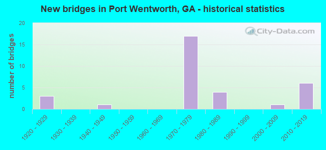
- New bridges - historical statistics
- 31920-1929
- 11940-1949
- 171970-1979
- 41980-1989
- 12000-2009
- 62010-2019

- Reconstructed bridges - Historical Statistics
- 31940-1949
- 01950-1959
- 01960-1969
- 01970-1979
- 11980-1989
- 121990-1999


- Bridge Condition - Deck
- 50.0%Very good
- 43.3%Good
- 6.7%Fair

- Bridge Condition - Superstructure
- 46.7%Very good
- 43.3%Good
- 3.3%Satisfactory
- 6.7%Poor

- Bridge Condition - Substructure
- 13.3%Very good
- 70.0%Good
- 10.0%Satisfactory
- 3.3%Fair
- 3.3%Poor

- Bridge Condition - Channel
- 62.5%Very good
- 31.3%Good
- 6.3%Satisfactory
Find on map >> Show street view
Structure Number: 510032, Location: IN PORT WENTWORTH CITY L (Lat: 32.172650, Lng: -81.187100), Route carried "on" structure: State highway 21, Year Built: 1980, Status: Open, Structure Length: 3.66m (12.01ft), Average Daily Traffic: 25,320 (year 2011), Truck Traffic: 1%, Average Future Daily Traffic: 37,980 (year 2031), Design Load: HS 20+Mod, Features Intersected: SAINT AUGUSTINE CREEK
Minimum Vertical Clearance: 30+ m (98+ ft), Kilometerpoint: 20.921, Lanes on structure: 2, Base Highway Network: Yes, Owner: State Highway Agency, Approaching Roadway Width: 11.3m (37.1ft), Skew: 10 degrees, Material/Design: Concrete, Design/Construction: Tee Beam, Number Of Spans In Main Unit: 3, Length of Maximum Span: 12.2m (40.0ft), Curb-To-Curb Width: 12.4m (40.7ft), Out-to-Out Width: 13.4m (44.0ft)
Condition: Deck: Good, Superstructure: Good, Substructure: Good, Channel: Very good, Operating Rating: 40.8 metric tons, Method Used To Determine Operating Rating: Load Factor (LF), Inventory Rating: 24.4 metric tons, Method Used To Determine Inventory Rating: Load Factor (LF), Structural Evaluation: Equal to present minimum criteria, Deck Geometry: Better than present minimum criteria, Waterway Adequacy: Equal to present desirable criteria, Approach Roadway Alignment: Equal to present desirable criteria, Designated Inspection Frequency: Every 24 months, Underwater Inspection Frequency: Every 60 months, Inspection Date: July 2020, Underwater Inspection Date: July 2019, Bridge Improvement Cost: $469,000, Roadway Improvement Cost: $47,000, Total Project Cost: $703,000, Deck Structure Type: Concrete Cast-file-Place
Find on map >> Show street view
Structure Number: 510033, Location: IN PORT WENTWORTH CITY L (Lat: 32.172647, Lng: -81.187308), Route carried "on" structure: State highway 21, Year Built: 1980, Status: Open, Structure Length: 3.66m (12.01ft), Average Daily Traffic: 25,320 (year 2011), Truck Traffic: 1%, Average Future Daily Traffic: 37,980 (year 2031), Design Load: HS 20+Mod, Features Intersected: SAINT AUGUSTINE CREEK
Minimum Vertical Clearance: 30+ m (98+ ft), Kilometerpoint: 20.921, Lanes on structure: 2, Base Highway Network: Yes, Owner: State Highway Agency, Approaching Roadway Width: 11.6m (38.1ft), Skew: 10 degrees, Material/Design: Concrete, Design/Construction: Tee Beam, Number Of Spans In Main Unit: 3, Length of Maximum Span: 12.2m (40.0ft), Curb-To-Curb Width: 12.4m (40.7ft), Out-to-Out Width: 13.4m (44.0ft)
Condition: Deck: Good, Superstructure: Good, Substructure: Good, Channel: Very good, Operating Rating: 40.8 metric tons, Method Used To Determine Operating Rating: Load Factor (LF), Inventory Rating: 24.4 metric tons, Method Used To Determine Inventory Rating: Load Factor (LF), Structural Evaluation: Equal to present minimum criteria, Deck Geometry: Better than present minimum criteria, Waterway Adequacy: Equal to present desirable criteria, Approach Roadway Alignment: Equal to present desirable criteria, Designated Inspection Frequency: Every 24 months, Underwater Inspection Frequency: Every 60 months, Inspection Date: July 2020, Underwater Inspection Date: July 2019, Bridge Improvement Cost: $469,000, Roadway Improvement Cost: $47,000, Total Project Cost: $703,000, Deck Structure Type: Concrete Cast-file-Place
Find on map >> Show street view
Structure Number: 510034, Location: 1 MI N OF PORT WENTWORTH (Lat: 32.183478, Lng: -81.190519), Route carried "on" structure: State highway 21, Year Built: 1980, Status: Open, Structure Length: 6.74m (22.11ft), Average Daily Traffic: 25,320 (year 2011), Truck Traffic: 1%, Average Future Daily Traffic: 37,980 (year 2031), Design Load: HS 20+Mod, Features Intersected: CSX RAILROAD
Minimum Vertical Clearance: 30+ m (98+ ft), Kilometerpoint: 22.531, Lanes on structure: 2, Base Highway Network: Yes, Owner: State Highway Agency, Approaching Roadway Width: 11.6m (38.1ft), Skew: 14 degrees, Material/Design: Prestressed concrete, Design/Construction: Stringer/Multi-beam, Number Of Spans In Main Unit: 3, Length of Maximum Span: 22.9m (75.1ft), Curb-To-Curb Width: 12.4m (40.7ft), Out-to-Out Width: 13.3m (43.6ft)
Condition: Deck: Good, Superstructure: Very good, Substructure: Good, Operating Rating: 66.2 metric tons, Method Used To Determine Operating Rating: Load Factor (LF), Inventory Rating: 37.1 metric tons, Method Used To Determine Inventory Rating: Load Factor (LF), Structural Evaluation: Better than present minimum criteria, Deck Geometry: Better than present minimum criteria, Underclear: Equal to present minimum criteria, Approach Roadway Alignment: Equal to present desirable criteria, Designated Inspection Frequency: Every 24 months, Inspection Date: July 2020, Bridge Improvement Cost: $863,000, Roadway Improvement Cost: $86,000, Total Project Cost: $1,295,000, Deck Structure Type: Concrete Cast-file-Place
Find on map >> Show street view
Structure Number: 510035, Location: 1 MI N OF PORT WENTWORTH (Lat: 32.183219, Lng: -81.190519), Route carried "on" structure: State highway 21, Year Built: 1980, Status: Open, Structure Length: 6.74m (22.11ft), Average Daily Traffic: 25,320 (year 2011), Truck Traffic: 1%, Average Future Daily Traffic: 37,980 (year 2031), Design Load: HS 20+Mod, Features Intersected: CSX RAILROAD
Minimum Vertical Clearance: 30+ m (98+ ft), Kilometerpoint: 22.531, Lanes on structure: 2, Base Highway Network: Yes, Owner: State Highway Agency, Approaching Roadway Width: 11.3m (37.1ft), Skew: 14 degrees, Material/Design: Prestressed concrete, Design/Construction: Stringer/Multi-beam, Number Of Spans In Main Unit: 3, Length of Maximum Span: 22.9m (75.1ft), Curb-To-Curb Width: 12.4m (40.7ft), Out-to-Out Width: 13.3m (43.6ft)
Condition: Deck: Good, Superstructure: Good, Substructure: Good, Operating Rating: 66.2 metric tons, Method Used To Determine Operating Rating: Load Factor (LF), Inventory Rating: 37.1 metric tons, Method Used To Determine Inventory Rating: Load Factor (LF), Structural Evaluation: Better than present minimum criteria, Deck Geometry: Better than present minimum criteria, Underclear: Equal to present minimum criteria, Approach Roadway Alignment: Equal to present desirable criteria, Designated Inspection Frequency: Every 24 months, Inspection Date: July 2020, Bridge Improvement Cost: $863,000, Roadway Improvement Cost: $86,000, Total Project Cost: $1,295,000, Deck Structure Type: Concrete Cast-file-Place
Find on map >> Show street view
Structure Number: 510036, Location: 3 MI N OF PORT WENTWORTH (Lat: 32.217867, Lng: -81.197556), Route carried "on" structure: State highway 21, Year Built: 1947, Year Reconstructed: 1989, Status: Open, Structure Length: 0.64m (2.10ft), Average Daily Traffic: 29,800 (year 2011), Truck Traffic: 8%, Average Future Daily Traffic: 44,700 (year 2031), Design Load: H 15, Features Intersected: BLACK CREEK
Minimum Vertical Clearance: 30+ m (98+ ft), Kilometerpoint: 25.750, Lanes on structure: 2, Base Highway Network: Yes, Owner: State Highway Agency, Approaching Roadway Width: 19.2m (63.0ft), Skew: 10 degrees, Material/Design: Concrete, Design/Construction: Culvert, Number Of Spans In Main Unit: 2, Length of Maximum Span: 3.0m (9.8ft)
Condition: Channel: Good, Culverts: Good, Operating Rating: 41.7 metric tons, Method Used To Determine Operating Rating: Field evaluation and documented engineering judgment, Inventory Rating: 24.4 metric tons, Method Used To Determine Inventory Rating: Field evaluation and documented engineering judgment, Structural Evaluation: Equal to present minimum criteria, Waterway Adequacy: Equal to present desirable criteria, Approach Roadway Alignment: Equal to present desirable criteria, Designated Inspection Frequency: Every 24 months, Inspection Date: July 2020, Bridge Improvement Cost: $82,000, Roadway Improvement Cost: $8,000, Total Project Cost: $123,000
Find on map >> Show street view
Structure Number: 510054, Location: 1 MI NE PORT WENTWORTH (Lat: 32.165397, Lng: -81.154528), Route carried "on" structure: State highway 25, Year Built: 1922, Year Reconstructed: 1954, Status: Posted for load, Structure Length: 44.65m (146.49ft), Average Daily Traffic: 3,570 (year 2012), Truck Traffic: 35%, Average Future Daily Traffic: 5,355 (year 2032), Design Load: HS 15, Features Intersected: SAVANNAH RIVER, Facility Carried by Structure: HOULIHAN BRIDGE
Minimum Vertical Clearance: 5.51m (18.08ft), Kilometerpoint: 32.187, Lanes on structure: 2, Base Highway Network: Yes, Owner: State Highway Agency, Approaching Roadway Width: 7.0m (23.0ft), Navigation Control: Yes ( Vertical Clearance: 4.5m (14.8ft), Horizontal Clearance: 27.4m (89.9ft)), Material/Design: Steel continuous, Design/Construction: Movable - Swing, Number Of Spans In Main Unit: 2, Number Of Approach Spans: 49, Length of Maximum Span: 36.6m (120.1ft), Curb or Sidewalk Widths: Left: 0.5m (1.6ft), Right: 0.5m (1.6ft), Curb-To-Curb Width: 8.5m (27.9ft), Out-to-Out Width: 10.2m (33.5ft)
Condition: Deck: Fair, Superstructure: Poor, Substructure: Poor, Channel: Satisfactory, Operating Rating: 34.4 metric tons, Method Used To Determine Operating Rating: Allowable Stress (AS), Inventory Rating: 20.8 metric tons, Method Used To Determine Inventory Rating: Allowable Stress (AS), Structural Evaluation: Meets minimum limits, Deck Geometry: Meets minimum limits, Waterway Adequacy: Equal to present desirable criteria, Approach Roadway Alignment: Equal to present desirable criteria, Length Of Structure Improvement: 84.92m (278.61ft), Designated Inspection Frequency: Every 24 months, Critical Feature Inspection Frequency: Every 12 months, Underwater Inspection Frequency: Every 60 months, Inspection Date: March 2020, Critical Feature Inspection Date: March 2021, Underwater Inspection Date: September 2019, Other Special Inspection Date: October 2020, Bridge Improvement Cost: $5,724,000, Roadway Improvement Cost: $572,000, Total Project Cost: $8,586,000, Deck Structure Type: Concrete Cast-file-Place, Wearing Surface/Protective System: Wearing Surface: Bituminous
Find on map >> Show street view
Structure Number: 510055, Location: 1 MI NE PORT WENTWORTH (Lat: 32.165739, Lng: -81.136547), Route carried "on" structure: State highway 25, Year Built: 1922, Year Reconstructed: 1953, Status: Open, Structure Length: 55.44m (181.89ft), Average Daily Traffic: 5,740 (year 2011), Truck Traffic: 1%, Average Future Daily Traffic: 8,610 (year 2031), Design Load: HS 15, Features Intersected: MIDDLE RIVER, Facility Carried by Structure: OCEAN HIGHWAY
Minimum Vertical Clearance: 30+ m (98+ ft), Kilometerpoint: 33.796, Lanes on structure: 2, Base Highway Network: Yes, Owner: State Highway Agency, Approaching Roadway Width: 7.0m (23.0ft), Material/Design: Concrete, Design/Construction: Tee Beam, Number Of Spans In Main Unit: 69, Length of Maximum Span: 11.0m (36.1ft), Curb or Sidewalk Widths: Left: 0.5m (1.6ft), Right: 0.5m (1.6ft), Curb-To-Curb Width: 8.5m (27.9ft), Out-to-Out Width: 10.2m (33.5ft)
Condition: Deck: Fair, Superstructure: Poor, Substructure: Satisfactory, Channel: Good, Operating Rating: 39.0 metric tons, Method Used To Determine Operating Rating: Allowable Stress (AS), Inventory Rating: 24.4 metric tons, Method Used To Determine Inventory Rating: Allowable Stress (AS), Structural Evaluation: Meets minimum limits, Deck Geometry: Meets minimum limits, Waterway Adequacy: Equal to present desirable criteria, Approach Roadway Alignment: Equal to present desirable criteria, Designated Inspection Frequency: Every 24 months, Underwater Inspection Frequency: Every 60 months, Inspection Date: August 2020, Underwater Inspection Date: September 2019, Bridge Improvement Cost: $7,107,000, Roadway Improvement Cost: $711,000, Total Project Cost: $10,661,000, Deck Structure Type: Concrete Cast-file-Place, Wearing Surface/Protective System: Wearing Surface: Bituminous
Find on map >> Show street view
Structure Number: 510069, Location: 1.5 MI W INT I-95 & SR 21 (Lat: 32.194278, Lng: -81.218769), Route carried "on" structure: State highway 30, Year Built: 1976, Status: Open, Structure Length: 8.29m (27.20ft), Average Daily Traffic: 8,190 (year 2011), Truck Traffic: 1%, Average Future Daily Traffic: 12,285 (year 2031), Design Load: HS 20+Mod, Features Intersected: CSX RAILROAD
Minimum Vertical Clearance: 30+ m (98+ ft), Kilometerpoint: 3.219, Lanes on structure: 2, Base Highway Network: Yes, Owner: State Highway Agency, Approaching Roadway Width: 12.8m (42.0ft), Material/Design: Steel, Design/Construction: Stringer/Multi-beam, Number Of Spans In Main Unit: 4, Length of Maximum Span: 23.8m (78.1ft), Curb-To-Curb Width: 13.0m (42.7ft), Out-to-Out Width: 14.0m (45.9ft)
Condition: Deck: Good, Superstructure: Good, Substructure: Good, Operating Rating: 47.1 metric tons, Method Used To Determine Operating Rating: Load Factor (LF), Inventory Rating: 28.1 metric tons, Method Used To Determine Inventory Rating: Load Factor (LF), Structural Evaluation: Better than present minimum criteria, Deck Geometry: Somewhat better than minimum adequacy, Underclear: Better than present minimum criteria, Approach Roadway Alignment: Equal to present desirable criteria, Designated Inspection Frequency: Every 24 months, Inspection Date: September 2020, Bridge Improvement Cost: $1,063,000, Roadway Improvement Cost: $106,000, Total Project Cost: $1,594,000, Deck Structure Type: Concrete Cast-file-Place
Find on map >> Show street view
Structure Number: 51012, Location: 1.6 MI S OF JCT SR 21 (Lat: 32.173289, Lng: -81.209858), Route carried "on" structure: Interstate 95, Year Built: 1976, Year Reconstructed: 1997, Status: Open, Structure Length: 5.30m (17.39ft), Average Daily Traffic: 61,760 (year 2011), Truck Traffic: 1%, Average Future Daily Traffic: 92,640 (year 2031), Design Load: HS 20+Mod, Features Intersected: AUGUSTINE CREEK
Minimum Vertical Clearance: 30+ m (98+ ft), Kilometerpoint: 172.200, Lanes on structure: 3, Base Highway Network: Yes, Owner: State Highway Agency, Approaching Roadway Width: 18.3m (60.0ft), Skew: 10 degrees, Material/Design: Steel, Design/Construction: Stringer/Multi-beam, Number Of Spans In Main Unit: 3, Length of Maximum Span: 17.7m (58.1ft), Curb-To-Curb Width: 19.2m (63.0ft), Out-to-Out Width: 24.1m (79.1ft)
Condition: Deck: Very good, Superstructure: Very good, Substructure: Good, Channel: Good, Operating Rating: 89.8 metric tons, Method Used To Determine Operating Rating: Load Factor (LF), Inventory Rating: 49.8 metric tons, Method Used To Determine Inventory Rating: Load Factor (LF), Structural Evaluation: Better than present minimum criteria, Deck Geometry: Superior to present desirable criteria, Waterway Adequacy: Equal to present desirable criteria, Approach Roadway Alignment: Equal to present desirable criteria, Designated Inspection Frequency: Every 24 months, Inspection Date: July 2020, Bridge Improvement Cost: $865,000, Roadway Improvement Cost: $87,000, Total Project Cost: $1,298,000, Deck Structure Type: Concrete Cast-file-Place, Wearing Surface/Protective System: Wearing Surface: Epoxy Overlay
Find on map >> Show street view
Structure Number: 510121, Location: 1.4 MI S OF JCT SR 21 (Lat: 32.174528, Lng: -81.208528), Route carried "on" structure: Interstate 95, Year Built: 1976, Year Reconstructed: 1997, Status: Open, Structure Length: 5.49m (18.01ft), Average Daily Traffic: 61,760 (year 2011), Truck Traffic: 1%, Average Future Daily Traffic: 92,640 (year 2031), Design Load: HS 20+Mod, Features Intersected: CSX RAILROAD
Minimum Vertical Clearance: 30+ m (98+ ft), Kilometerpoint: 172.200, Lanes on structure: 3, Base Highway Network: Yes, Owner: State Highway Agency, Approaching Roadway Width: 18.3m (60.0ft), Skew: 13 degrees, Material/Design: Steel, Design/Construction: Stringer/Multi-beam, Number Of Spans In Main Unit: 3, Length of Maximum Span: 18.3m (60.0ft), Curb-To-Curb Width: 23.2m (76.1ft), Out-to-Out Width: 24.1m (79.1ft)
Condition: Deck: Very good, Superstructure: Very good, Substructure: Good, Operating Rating: 44.4 metric tons, Method Used To Determine Operating Rating: Load Factor (LF), Inventory Rating: 26.3 metric tons, Method Used To Determine Inventory Rating: Load Factor (LF), Structural Evaluation: Equal to present minimum criteria, Deck Geometry: Superior to present desirable criteria, Underclear: Superior to present desirable criteria, Approach Roadway Alignment: Equal to present desirable criteria, Designated Inspection Frequency: Every 24 months, Inspection Date: August 2020, Bridge Improvement Cost: $895,000, Roadway Improvement Cost: $90,000, Total Project Cost: $1,343,000, Deck Structure Type: Concrete Cast-file-Place, Wearing Surface/Protective System: Wearing Surface: Epoxy Overlay
Find on map >> Show street view
Structure Number: 510122, Location: 1.4 MI S OF JCT SR 21 (Lat: 32.174678, Lng: -81.208697), Route carried "on" structure: Interstate 95, Year Built: 1976, Year Reconstructed: 1997, Status: Open, Structure Length: 5.49m (18.01ft), Average Daily Traffic: 61,760 (year 2011), Truck Traffic: 1%, Average Future Daily Traffic: 92,640 (year 2031), Design Load: HS 20+Mod, Features Intersected: CSX RAILROAD
Minimum Vertical Clearance: 30+ m (98+ ft), Kilometerpoint: 172.200, Lanes on structure: 3, Base Highway Network: Yes, Owner: State Highway Agency, Approaching Roadway Width: 18.3m (60.0ft), Skew: 13 degrees, Material/Design: Steel, Design/Construction: Stringer/Multi-beam, Number Of Spans In Main Unit: 3, Length of Maximum Span: 18.3m (60.0ft), Curb-To-Curb Width: 23.2m (76.1ft), Out-to-Out Width: 24.1m (79.1ft)
Condition: Deck: Very good, Superstructure: Very good, Substructure: Good, Operating Rating: 46.2 metric tons, Method Used To Determine Operating Rating: Load Factor (LF), Inventory Rating: 27.2 metric tons, Method Used To Determine Inventory Rating: Load Factor (LF), Structural Evaluation: Equal to present minimum criteria, Deck Geometry: Superior to present desirable criteria, Underclear: Superior to present desirable criteria, Approach Roadway Alignment: Equal to present desirable criteria, Designated Inspection Frequency: Every 24 months, Inspection Date: August 2020, Bridge Improvement Cost: $895,000, Roadway Improvement Cost: $90,000, Total Project Cost: $1,343,000, Deck Structure Type: Concrete Cast-file-Place, Wearing Surface/Protective System: Wearing Surface: Epoxy Overlay
Find on map >> Show street view
Structure Number: 510123, Location: 1.3 MI S OF JCT SR 21 (Lat: 32.175778, Lng: -81.207489), Route carried "on" structure: Interstate 95, Year Built: 1976, Year Reconstructed: 1997, Status: Open, Structure Length: 5.55m (18.21ft), Average Daily Traffic: 61,760 (year 2011), Truck Traffic: 1%, Average Future Daily Traffic: 92,640 (year 2031), Design Load: HS 20+Mod, Features Intersected: CSX RAILROAD
Minimum Vertical Clearance: 30+ m (98+ ft), Kilometerpoint: 172.200, Lanes on structure: 3, Base Highway Network: Yes, Owner: State Highway Agency, Approaching Roadway Width: 18.3m (60.0ft), Skew: 12 degrees, Material/Design: Steel, Design/Construction: Stringer/Multi-beam, Number Of Spans In Main Unit: 3, Length of Maximum Span: 18.6m (61.0ft), Curb-To-Curb Width: 23.2m (76.1ft), Out-to-Out Width: 24.1m (79.1ft)
Condition: Deck: Very good, Superstructure: Very good, Substructure: Good, Operating Rating: 47.1 metric tons, Method Used To Determine Operating Rating: Load Factor (LF), Inventory Rating: 28.1 metric tons, Method Used To Determine Inventory Rating: Load Factor (LF), Structural Evaluation: Better than present minimum criteria, Deck Geometry: Superior to present desirable criteria, Underclear: Superior to present desirable criteria, Approach Roadway Alignment: Equal to present desirable criteria, Designated Inspection Frequency: Every 24 months, Inspection Date: August 2020, Bridge Improvement Cost: $905,000, Roadway Improvement Cost: $91,000, Total Project Cost: $1,358,000, Deck Structure Type: Concrete Cast-file-Place, Wearing Surface/Protective System: Wearing Surface: Epoxy Overlay
Find on map >> Show street view
Structure Number: 510124, Location: 1.3 MI S OF JCT SR 21 (Lat: 32.175919, Lng: -81.207669), Route carried "on" structure: Interstate 95, Year Built: 1976, Year Reconstructed: 1997, Status: Open, Structure Length: 5.55m (18.21ft), Average Daily Traffic: 61,760 (year 2011), Truck Traffic: 1%, Average Future Daily Traffic: 92,640 (year 2031), Design Load: HS 20+Mod, Features Intersected: CSX RAILROAD
Minimum Vertical Clearance: 30+ m (98+ ft), Kilometerpoint: 172.200, Lanes on structure: 3, Base Highway Network: Yes, Owner: State Highway Agency, Approaching Roadway Width: 17.7m (58.1ft), Skew: 12 degrees, Material/Design: Steel, Design/Construction: Stringer/Multi-beam, Number Of Spans In Main Unit: 3, Length of Maximum Span: 18.6m (61.0ft), Curb-To-Curb Width: 19.6m (64.3ft), Out-to-Out Width: 24.1m (79.1ft)
Condition: Deck: Very good, Superstructure: Very good, Substructure: Good, Operating Rating: 47.1 metric tons, Method Used To Determine Operating Rating: Load Factor (LF), Inventory Rating: 28.1 metric tons, Method Used To Determine Inventory Rating: Load Factor (LF), Structural Evaluation: Better than present minimum criteria, Deck Geometry: Superior to present desirable criteria, Underclear: Superior to present desirable criteria, Approach Roadway Alignment: Equal to present desirable criteria, Designated Inspection Frequency: Every 24 months, Inspection Date: August 2020, Bridge Improvement Cost: $905,000, Roadway Improvement Cost: $91,000, Total Project Cost: $1,358,000, Deck Structure Type: Concrete Cast-file-Place, Wearing Surface/Protective System: Wearing Surface: Epoxy Overlay
Find on map >> Show street view
Structure Number: 510125, Location: INT I-95 & SR 21 (Lat: 32.191089, Lng: -81.194706), Route carried "on" structure: Interstate 95, Year Built: 1976, Year Reconstructed: 1995, Status: Open, Structure Length: 9.85m (32.32ft), Average Daily Traffic: 45,740 (year 2011), Truck Traffic: 20%, Average Future Daily Traffic: 68,610 (year 2031), Design Load: HS 20+Mod, Features Intersected: SR 21
Minimum Vertical Clearance: 30+ m (98+ ft), Kilometerpoint: 175.419, Lanes on structure: 3, Lanes under structure: 6, Base Highway Network: Yes, Owner: State Highway Agency, Approaching Roadway Width: 18.3m (60.0ft), Skew: 13 degrees, Material/Design: Steel continuous, Design/Construction: Stringer/Multi-beam, Number Of Spans In Main Unit: 4, Length of Maximum Span: 33.2m (108.9ft), Curb-To-Curb Width: 19.5m (64.0ft), Out-to-Out Width: 24.1m (79.1ft)
Condition: Deck: Very good, Superstructure: Very good, Substructure: Good, Operating Rating: 48.9 metric tons, Method Used To Determine Operating Rating: Load Factor (LF), Inventory Rating: 29.0 metric tons, Method Used To Determine Inventory Rating: Load Factor (LF), Structural Evaluation: Better than present minimum criteria, Deck Geometry: Superior to present desirable criteria, Underclear: Better than present minimum criteria, Approach Roadway Alignment: Equal to present desirable criteria, Designated Inspection Frequency: Every 24 months, Inspection Date: July 2020, Bridge Improvement Cost: $1,606,000, Roadway Improvement Cost: $161,000, Total Project Cost: $2,409,000, Deck Structure Type: Concrete Cast-file-Place, Wearing Surface/Protective System: Wearing Surface: Epoxy Overlay
Find on map >> Show street view
Structure Number: 510126, Location: INT I-95 & SR 21 (Lat: 32.191417, Lng: -81.194767), Route carried "on" structure: Interstate 95, Year Built: 1976, Year Reconstructed: 1995, Status: Open, Structure Length: 9.85m (32.32ft), Average Daily Traffic: 45,740 (year 2011), Truck Traffic: 20%, Average Future Daily Traffic: 68,610 (year 2031), Design Load: HS 20+Mod, Features Intersected: SR 21
Minimum Vertical Clearance: 30+ m (98+ ft), Kilometerpoint: 175.419, Lanes on structure: 3, Lanes under structure: 6, Base Highway Network: Yes, Owner: State Highway Agency, Approaching Roadway Width: 17.7m (58.1ft), Skew: 13 degrees, Material/Design: Steel continuous, Design/Construction: Stringer/Multi-beam, Number Of Spans In Main Unit: 4, Length of Maximum Span: 33.2m (108.9ft), Curb-To-Curb Width: 19.7m (64.6ft), Out-to-Out Width: 24.1m (79.1ft)
Condition: Deck: Very good, Superstructure: Good, Substructure: Good, Operating Rating: 48.9 metric tons, Method Used To Determine Operating Rating: Load Factor (LF), Inventory Rating: 29.0 metric tons, Method Used To Determine Inventory Rating: Load Factor (LF), Structural Evaluation: Better than present minimum criteria, Deck Geometry: Superior to present desirable criteria, Underclear: Better than present minimum criteria, Approach Roadway Alignment: Equal to present desirable criteria, Designated Inspection Frequency: Every 24 months, Inspection Date: July 2020, Bridge Improvement Cost: $1,606,000, Roadway Improvement Cost: $161,000, Total Project Cost: $2,409,000, Deck Structure Type: Concrete Cast-file-Place, Wearing Surface/Protective System: Wearing Surface: Epoxy Overlay
Find on map >> Show street view
Structure Number: 510127, Location: 0.7 MI N OF JCT SR 21 (Lat: 32.198989, Lng: -81.188119), Route carried "on" structure: Interstate 95, Year Built: 1976, Year Reconstructed: 1996, Status: Open, Structure Length: 4.15m (13.62ft), Average Daily Traffic: 45,740 (year 2011), Truck Traffic: 20%, Average Future Daily Traffic: 68,610 (year 2031), Design Load: HS 20+Mod, Features Intersected: BLACK CREEK
Minimum Vertical Clearance: 30+ m (98+ ft), Kilometerpoint: 175.419, Lanes on structure: 3, Base Highway Network: Yes, Owner: State Highway Agency, Approaching Roadway Width: 22.9m (75.1ft), Skew: 10 degrees, Material/Design: Concrete, Design/Construction: Tee Beam, Number Of Spans In Main Unit: 4, Length of Maximum Span: 10.4m (34.1ft), Curb-To-Curb Width: 23.2m (76.1ft), Out-to-Out Width: 24.3m (79.7ft)
Condition: Deck: Very good, Superstructure: Good, Substructure: Good, Channel: Very good, Operating Rating: 39.9 metric tons, Method Used To Determine Operating Rating: Load Factor (LF), Inventory Rating: 23.5 metric tons, Method Used To Determine Inventory Rating: Load Factor (LF), Structural Evaluation: Somewhat better than minimum adequacy, Deck Geometry: Superior to present desirable criteria, Waterway Adequacy: Equal to present desirable criteria, Approach Roadway Alignment: Equal to present desirable criteria, Designated Inspection Frequency: Every 24 months, Inspection Date: July 2020, Bridge Improvement Cost: $676,000, Roadway Improvement Cost: $68,000, Total Project Cost: $1,014,000, Deck Structure Type: Concrete Cast-file-Place, Wearing Surface/Protective System: Wearing Surface: Epoxy Overlay
Find on map >> Show street view
Structure Number: 510128, Location: 0.7 MI N OF JCT SR 21 (Lat: 32.199108, Lng: -81.188308), Route carried "on" structure: Interstate 95, Year Built: 1976, Year Reconstructed: 1996, Status: Open, Structure Length: 4.15m (13.62ft), Average Daily Traffic: 45,740 (year 2011), Truck Traffic: 20%, Average Future Daily Traffic: 68,610 (year 2031), Design Load: HS 20+Mod, Features Intersected: BLACK CREEK
Minimum Vertical Clearance: 30+ m (98+ ft), Kilometerpoint: 175.419, Lanes on structure: 3, Base Highway Network: Yes, Owner: State Highway Agency, Approaching Roadway Width: 18.9m (62.0ft), Skew: 10 degrees, Material/Design: Concrete, Design/Construction: Tee Beam, Number Of Spans In Main Unit: 4, Length of Maximum Span: 10.4m (34.1ft), Curb-To-Curb Width: 20.0m (65.6ft), Out-to-Out Width: 24.3m (79.7ft)
Condition: Deck: Very good, Superstructure: Good, Substructure: Good, Channel: Very good, Operating Rating: 39.9 metric tons, Method Used To Determine Operating Rating: Load Factor (LF), Inventory Rating: 23.5 metric tons, Method Used To Determine Inventory Rating: Load Factor (LF), Structural Evaluation: Somewhat better than minimum adequacy, Deck Geometry: Superior to present desirable criteria, Waterway Adequacy: Equal to present desirable criteria, Approach Roadway Alignment: Equal to present desirable criteria, Designated Inspection Frequency: Every 24 months, Inspection Date: July 2020, Bridge Improvement Cost: $676,000, Roadway Improvement Cost: $68,000, Total Project Cost: $1,014,000, Deck Structure Type: Concrete Cast-file-Place, Wearing Surface/Protective System: Wearing Surface: Epoxy Overlay
Find on map >> Show street view
Structure Number: 510129, Location: 3.7 MI N OF JCT SR 21 (Lat: 32.229078, Lng: -81.160228), Route carried "on" structure: Interstate 95, Year Built: 1976, Year Reconstructed: 1996, Status: Open, Structure Length: 33.74m (110.70ft), Average Daily Traffic: 45,740 (year 2011), Truck Traffic: 20%, Average Future Daily Traffic: 68,610 (year 2031), Design Load: HS 20+Mod, Features Intersected: KNOXBORO CREEK
Minimum Vertical Clearance: 30+ m (98+ ft), Kilometerpoint: 180.247, Lanes on structure: 3, Base Highway Network: Yes, Owner: State Highway Agency, Approaching Roadway Width: 22.9m (75.1ft), Skew: 10 degrees, Material/Design: Concrete, Design/Construction: Tee Beam, Number Of Spans In Main Unit: 27, Length of Maximum Span: 12.5m (41.0ft), Curb-To-Curb Width: 23.2m (76.1ft), Out-to-Out Width: 24.1m (79.1ft)
Condition: Deck: Very good, Superstructure: Good, Substructure: Good, Channel: Very good, Operating Rating: 40.8 metric tons, Method Used To Determine Operating Rating: Load Factor (LF), Inventory Rating: 24.4 metric tons, Method Used To Determine Inventory Rating: Load Factor (LF), Structural Evaluation: Equal to present minimum criteria, Deck Geometry: Superior to present desirable criteria, Waterway Adequacy: Equal to present desirable criteria, Approach Roadway Alignment: Equal to present desirable criteria, Designated Inspection Frequency: Every 24 months, Underwater Inspection Frequency: Every 60 months, Inspection Date: July 2020, Underwater Inspection Date: September 2019, Bridge Improvement Cost: $5,505,000, Roadway Improvement Cost: $550,000, Total Project Cost: $8,257,000, Deck Structure Type: Concrete Cast-file-Place, Wearing Surface/Protective System: Wearing Surface: Epoxy Overlay
Find on map >> Show street view
Structure Number: 51013, Location: 3.7 MI N OF JCT SR 21 (Lat: 32.229419, Lng: -81.160200), Route carried "on" structure: Interstate 95, Year Built: 1976, Year Reconstructed: 1996, Status: Open, Structure Length: 33.74m (110.70ft), Average Daily Traffic: 45,740 (year 2011), Truck Traffic: 20%, Average Future Daily Traffic: 68,610 (year 2031), Design Load: HS 20+Mod, Features Intersected: KNOXBORO CREEK
Minimum Vertical Clearance: 30+ m (98+ ft), Kilometerpoint: 180.247, Lanes on structure: 3, Base Highway Network: Yes, Owner: State Highway Agency, Approaching Roadway Width: 23.5m (77.1ft), Skew: 10 degrees, Material/Design: Concrete, Design/Construction: Tee Beam, Number Of Spans In Main Unit: 27, Length of Maximum Span: 12.5m (41.0ft), Curb-To-Curb Width: 11.0m (36.1ft), Out-to-Out Width: 23.5m (77.1ft)
Condition: Deck: Very good, Superstructure: Good, Substructure: Good, Channel: Very good, Operating Rating: 40.8 metric tons, Method Used To Determine Operating Rating: Load Factor (LF), Inventory Rating: 24.4 metric tons, Method Used To Determine Inventory Rating: Load Factor (LF), Structural Evaluation: Equal to present minimum criteria, Deck Geometry: High priority of replacement, Waterway Adequacy: Equal to present desirable criteria, Approach Roadway Alignment: Equal to present desirable criteria, Designated Inspection Frequency: Every 24 months, Underwater Inspection Frequency: Every 60 months, Inspection Date: July 2020, Underwater Inspection Date: September 2019, Bridge Improvement Cost: $5,505,000, Roadway Improvement Cost: $550,000, Total Project Cost: $8,257,000, Deck Structure Type: Concrete Cast-file-Place, Wearing Surface/Protective System: Wearing Surface: Epoxy Overlay
Find on map >> Show street view
Structure Number: 510138, Location: 1 MI S INT I-95 & SR 21 (Lat: 32.180239, Lng: -81.203950), Route carried "on" structure: City street 4070, Year Built: 1975, Status: Open, Structure Length: 9.33m (30.61ft), Average Daily Traffic: 940 (year 2011), Truck Traffic: 1%, Average Future Daily Traffic: 1,410 (year 2031), Design Load: HS 15, Features Intersected: I-95 (SR 405), Facility Carried by Structure: MONTEITH ROAD
Minimum Vertical Clearance: 30+ m (98+ ft), Kilometerpoint: 4.828, Lanes on structure: 2, Lanes under structure: 6, Base Highway Network: Yes, Owner: State Highway Agency, Approaching Roadway Width: 6.7m (22.0ft), Skew: 3 degrees, Material/Design: Steel continuous, Design/Construction: Stringer/Multi-beam, Number Of Spans In Main Unit: 4, Length of Maximum Span: 32.3m (106.0ft), Curb or Sidewalk Widths: Left: 0.2m (0.7ft), Right: 0.2m (0.7ft), Curb-To-Curb Width: 9.4m (30.8ft), Out-to-Out Width: 10.5m (34.4ft)
Condition: Deck: Very good, Superstructure: Very good, Substructure: Good, Operating Rating: 28.1 metric tons, Method Used To Determine Operating Rating: Load Factor (LF), Inventory Rating: 17.2 metric tons, Method Used To Determine Inventory Rating: Load Factor (LF), Structural Evaluation: Meets minimum limits, Deck Geometry: Equal to present minimum criteria, Underclear: Better than present minimum criteria, Approach Roadway Alignment: Equal to present desirable criteria, Designated Inspection Frequency: Every 24 months, Inspection Date: July 2020, Bridge Improvement Cost: $1,196,000, Roadway Improvement Cost: $120,000, Total Project Cost: $1,793,000, Deck Structure Type: Concrete Cast-file-Place, Wearing Surface/Protective System: Wearing Surface: Epoxy Overlay
Find on map >> Show street view
Structure Number: 510158, Location: 0.5 MI N OF JCT SR 21 (Lat: 32.196756, Lng: -81.189942), Route carried "on" structure: Interstate 95, Year Built: 1976, Year Reconstructed: 1995, Status: Open, Structure Length: 1.04m (3.41ft), Average Daily Traffic: 45,740 (year 2011), Truck Traffic: 20%, Average Future Daily Traffic: 68,610 (year 2031), Design Load: HS 20+Mod, Features Intersected: CHATHAM CO WATER LINES
Minimum Vertical Clearance: 30+ m (98+ ft), Kilometerpoint: 175.419, Lanes on structure: 6, Base Highway Network: Yes, Owner: State Highway Agency, Approaching Roadway Width: 39.6m (129.9ft), Skew: 16 degrees, Material/Design: Concrete, Design/Construction: Culvert, Number Of Spans In Main Unit: 1, Length of Maximum Span: 10.4m (34.1ft)
Condition: Channel: Very good, Culverts: Good, Operating Rating: 55.3 metric tons, Method Used To Determine Operating Rating: Field evaluation and documented engineering judgment, Inventory Rating: 32.6 metric tons, Method Used To Determine Inventory Rating: Field evaluation and documented engineering judgment, Structural Evaluation: Better than present minimum criteria, Waterway Adequacy: Equal to present desirable criteria, Approach Roadway Alignment: Equal to present desirable criteria, Designated Inspection Frequency: Every 24 months, Inspection Date: July 2020, Bridge Improvement Cost: $278,000, Roadway Improvement Cost: $28,000, Total Project Cost: $417,000
Find on map >> Show street view
Structure Number: 515001, Location: 4 MI N OF PORT WENTWORTH (Lat: 32.198658, Lng: -81.187539), Route carried "on" structure: County highway 4, Year Built: 1976, Status: Posted for load, Structure Length: 3.29m (10.79ft), Average Daily Traffic: 1,140 (year 2011), Truck Traffic: 1%, Average Future Daily Traffic: 1,710 (year 2031), Design Load: HS 15, Features Intersected: BLACK CREEK, Facility Carried by Structure: OLEARY ROAD
Minimum Vertical Clearance: 30+ m (98+ ft), Kilometerpoint: 1.609, Lanes on structure: 2, Base Highway Network: Yes, Owner: County Highway Agency, Approaching Roadway Width: 6.7m (22.0ft), Material/Design: Concrete, Design/Construction: Tee Beam, Number Of Spans In Main Unit: 3, Length of Maximum Span: 11.0m (36.1ft), Curb or Sidewalk Widths: Left: 0.2m (0.7ft), Right: 0.2m (0.7ft), Curb-To-Curb Width: 8.7m (28.5ft), Out-to-Out Width: 10.0m (32.8ft)
Condition: Deck: Good, Superstructure: Good, Substructure: Good, Channel: Good, Operating Rating: 31.7 metric tons, Method Used To Determine Operating Rating: Load Factor (LF), Inventory Rating: 19.0 metric tons, Method Used To Determine Inventory Rating: Load Factor (LF), Structural Evaluation: Somewhat better than minimum adequacy, Deck Geometry: Somewhat better than minimum adequacy, Waterway Adequacy: Equal to present desirable criteria, Approach Roadway Alignment: Equal to present desirable criteria, Bridge Posting: Required (Relationship of Operating Rating to Maximum Legal Load: 0.1 - 9.9% below), Designated Inspection Frequency: Every 24 months, Inspection Date: July 2020, Bridge Improvement Cost: $422,000, Roadway Improvement Cost: $42,000, Total Project Cost: $633,000, Deck Structure Type: Concrete Cast-file-Place
Find on map >> Show street view
Structure Number: 51506, Location: PORT WENWORTH C L (Lat: 32.163553, Lng: -81.184592), Route carried "on" structure: Business County highway 984, Year Built: 2001, Status: Open, Structure Length: 8.32m (27.30ft), Average Daily Traffic: 5,530 (year 2011), Truck Traffic: 1%, Average Future Daily Traffic: 8,295 (year 2031), Design Load: HS 20+Mod, Features Intersected: SR 21, NORFORK SOUTHERN, Facility Carried by Structure: JIMMY DELOACH PKY
Minimum Vertical Clearance: 30+ m (98+ ft), Kilometerpoint: 12.875, Lanes on structure: 4, Lanes under structure: 4, Base Highway Network: Yes, Owner: State Highway Agency, Approaching Roadway Width: 22.3m (73.2ft), Skew: 20 degrees, Material/Design: Prestressed concrete, Design/Construction: Stringer/Multi-beam, Number Of Spans In Main Unit: 3, Length of Maximum Span: 33.5m (109.9ft), Curb-To-Curb Width: 21.6m (70.9ft), Out-to-Out Width: 25.2m (82.7ft)
Condition: Deck: Good, Superstructure: Good, Substructure: Good, Operating Rating: 39.0 metric tons, Method Used To Determine Operating Rating: Allowable Stress (AS), Inventory Rating: 24.4 metric tons, Method Used To Determine Inventory Rating: Allowable Stress (AS), Structural Evaluation: Equal to present minimum criteria, Deck Geometry: Superior to present desirable criteria, Underclear: Superior to present desirable criteria, Approach Roadway Alignment: Equal to present desirable criteria, Designated Inspection Frequency: Every 24 months, Inspection Date: June 2021, Bridge Improvement Cost: $1,648,000, Roadway Improvement Cost: $165,000, Total Project Cost: $2,473,000, Deck Structure Type: Concrete Cast-file-Place
Find on map >> Show street view
Structure Number: 515098, Location: PORT WENTWORTH CITY LIMIT (Lat: 32.163231, Lng: -81.179517), Route carried "on" structure: County highway 984, Year Built: 2015, Status: Open, Structure Length: 3.78m (12.40ft), Average Daily Traffic: 5,530 (year 2011), Truck Traffic: 1%, Average Future Daily Traffic: 8,295 (year 2031), Design Load: HS 20+Mod, Features Intersected: SONNY DIXON INTERCHANGE, Facility Carried by Structure: JIMMY DELOACH PARK
Minimum Vertical Clearance: 30+ m (98+ ft), Kilometerpoint: 14.484, Lanes on structure: 4, Lanes under structure: 4, Base Highway Network: Yes, Owner: State Highway Agency, Approaching Roadway Width: 23.9m (78.4ft), Skew: 30 degrees, Material/Design: Prestressed concrete, Design/Construction: Stringer/Multi-beam, Number Of Spans In Main Unit: 1, Length of Maximum Span: 37.8m (124.0ft), Curb-To-Curb Width: 21.6m (70.9ft), Out-to-Out Width: 24.4m (80.1ft)
Condition: Deck: Good, Superstructure: Very good, Substructure: Very good, Operating Rating: 86.1 metric tons, Method Used To Determine Operating Rating: Load Factor (LF), Inventory Rating: 51.7 metric tons, Method Used To Determine Inventory Rating: Load Factor (LF), Structural Evaluation: Equal to present desirable criteria, Deck Geometry: Superior to present desirable criteria, Underclear: Superior to present desirable criteria, Approach Roadway Alignment: Equal to present desirable criteria, Length Of Structure Improvement: 4.54m (14.90ft), Designated Inspection Frequency: Every 24 months, Inspection Date: September 2020, Bridge Improvement Cost: $11,026,000, Roadway Improvement Cost: $1,103,000, Total Project Cost: $16,539,000 ( Estimate for 2016), Deck Structure Type: Concrete Cast-file-Place
Find on map >> Show street view
Structure Number: 515099, Location: PORT WENTWORTH CITY LIMIT (Lat: 32.160531, Lng: -81.177667), Route carried "on" structure: County highway 984, Year Built: 2015, Status: Open, Structure Length: 7.77m (25.49ft), Average Daily Traffic: 3,170 (year 2011), Truck Traffic: 1%, Average Future Daily Traffic: 4,755 (year 2031), Design Load: HS 20+Mod, Features Intersected: ST. AUGUSTINE CREEK TRIB, Facility Carried by Structure: JIMMY DELOACH CONN
Minimum Vertical Clearance: 30+ m (98+ ft), Kilometerpoint: 14.484, Lanes on structure: 5, Base Highway Network: Yes, Owner: County Highway Agency, Approaching Roadway Width: 14.9m (48.9ft), Material/Design: Prestressed concrete, Design/Construction: Stringer/Multi-beam, Number Of Spans In Main Unit: 3, Length of Maximum Span: 26.2m (86.0ft), Curb-To-Curb Width: 11.0m (36.1ft), Out-to-Out Width: 27.4m (89.9ft)
Condition: Deck: Good, Superstructure: Very good, Substructure: Good, Channel: Very good, Operating Rating: 86.1 metric tons, Method Used To Determine Operating Rating: Load Factor (LF), Inventory Rating: 39.9 metric tons, Method Used To Determine Inventory Rating: Load Factor (LF), Structural Evaluation: Better than present minimum criteria, Deck Geometry: High priority of replacement, Waterway Adequacy: Equal to present desirable criteria, Approach Roadway Alignment: Equal to present desirable criteria, Length Of Structure Improvement: 9.33m (30.61ft), Designated Inspection Frequency: Every 24 months, Inspection Date: October 2020, Bridge Improvement Cost: $22,644,000, Roadway Improvement Cost: $2,264,000, Total Project Cost: $33,966,000 ( Estimate for 2016), Deck Structure Type: Concrete Cast-file-Place
Find on map >> Show street view
Structure Number: 5151, Location: PORT WENTWORTH CITY LIMIT (Lat: 32.155250, Lng: -81.176400), Route carried "on" structure: County highway 984, Year Built: 2015, Status: Open, Structure Length: 2.96m (9.71ft), Average Daily Traffic: 5,530 (year 2011), Truck Traffic: 1%, Average Future Daily Traffic: 8,295 (year 2031), Design Load: HS 20+Mod, Features Intersected: SR-30 (BONNY BRIDGE ROAD, Facility Carried by Structure: JIMMY DELOACH PARK
Minimum Vertical Clearance: 30+ m (98+ ft), Kilometerpoint: 14.484, Lanes on structure: 4, Lanes under structure: 4, Base Highway Network: Yes, Owner: State Highway Agency, Approaching Roadway Width: 24.2m (79.4ft), Skew: 30 degrees, Material/Design: Prestressed concrete, Design/Construction: Stringer/Multi-beam, Number Of Spans In Main Unit: 1, Length of Maximum Span: 29.6m (97.1ft), Curb-To-Curb Width: 11.0m (36.1ft), Out-to-Out Width: 24.4m (80.1ft)
Condition: Deck: Good, Superstructure: Very good, Substructure: Very good, Operating Rating: 83.4 metric tons, Method Used To Determine Operating Rating: Load Factor (LF), Inventory Rating: 48.9 metric tons, Method Used To Determine Inventory Rating: Load Factor (LF), Structural Evaluation: Equal to present desirable criteria, Deck Geometry: High priority of replacement, Underclear: Superior to present desirable criteria, Approach Roadway Alignment: Equal to present desirable criteria, Length Of Structure Improvement: 3.54m (11.61ft), Designated Inspection Frequency: Every 24 months, Inspection Date: October 2020, Bridge Improvement Cost: $8,584,000, Roadway Improvement Cost: $858,000, Total Project Cost: $12,876,000 ( Estimate for 2016), Deck Structure Type: Concrete Cast-file-Place
Find on map >> Show street view
Structure Number: 515101, Location: PORT WENTWORTH CITY LIMIT (Lat: 32.153867, Lng: -81.176181), Route carried "on" structure: County highway 984, Year Built: 2015, Status: Open, Structure Length: 3.66m (12.01ft), Average Daily Traffic: 5,530 (year 2011), Truck Traffic: 1%, Average Future Daily Traffic: 8,295 (year 2031), Design Load: HS 20+Mod, Features Intersected: NORFOLK SOUTHERN RAILROA, Facility Carried by Structure: JIMMY DELOACH PARK
Minimum Vertical Clearance: 30+ m (98+ ft), Kilometerpoint: 14.484, Lanes on structure: 4, Base Highway Network: Yes, Owner: State Highway Agency, Approaching Roadway Width: 23.9m (78.4ft), Skew: 30 degrees, Material/Design: Prestressed concrete, Design/Construction: Stringer/Multi-beam, Number Of Spans In Main Unit: 1, Length of Maximum Span: 36.6m (120.1ft), Curb-To-Curb Width: 21.9m (71.9ft), Out-to-Out Width: 24.4m (80.1ft)
Condition: Deck: Very good, Superstructure: Very good, Substructure: Good, Operating Rating: 84.3 metric tons, Method Used To Determine Operating Rating: Load Factor (LF), Inventory Rating: 50.8 metric tons, Method Used To Determine Inventory Rating: Load Factor (LF), Structural Evaluation: Better than present minimum criteria, Deck Geometry: Superior to present desirable criteria, Underclear: Superior to present desirable criteria, Approach Roadway Alignment: Equal to present desirable criteria, Length Of Structure Improvement: 4.39m (14.40ft), Designated Inspection Frequency: Every 24 months, Inspection Date: October 2020, Bridge Improvement Cost: $10,656,000, Roadway Improvement Cost: $1,066,000, Total Project Cost: $15,984,000 ( Estimate for 2016), Deck Structure Type: Concrete Cast-file-Place
Find on map >> Show street view
Structure Number: 515102, Location: PORT WENTWORTH CITY LIMIT (Lat: 32.147317, Lng: -81.173467), Route carried "on" structure: County highway 984, Year Built: 2015, Status: Open, Structure Length: 3.11m (10.20ft), Average Daily Traffic: 8,380 (year 2017), Truck Traffic: 1%, Design Load: HS 20+Mod, Features Intersected: CROSSGATE ROAD, Facility Carried by Structure: JIMMY DELOACH PARK
Minimum Vertical Clearance: 30+ m (98+ ft), Kilometerpoint: 16.093, Lanes on structure: 4, Lanes under structure: 2, Owner: County Highway Agency, Approaching Roadway Width: 24.2m (79.4ft), Skew: 30 degrees, Material/Design: Prestressed concrete, Design/Construction: Stringer/Multi-beam, Number Of Spans In Main Unit: 1, Length of Maximum Span: 31.1m (102.0ft), Curb-To-Curb Width: 11.0m (36.1ft), Out-to-Out Width: 24.4m (80.1ft)
Condition: Deck: Very good, Superstructure: Very good, Substructure: Very good, Operating Rating: 82.5 metric tons, Method Used To Determine Operating Rating: Load Factor (LF), Inventory Rating: 48.9 metric tons, Method Used To Determine Inventory Rating: Load Factor (LF), Structural Evaluation: Equal to present desirable criteria, Deck Geometry: High priority of replacement, Underclear: Superior to present desirable criteria, Approach Roadway Alignment: Equal to present desirable criteria, Length Of Structure Improvement: 3.72m (12.20ft), Designated Inspection Frequency: Every 24 months, Inspection Date: October 2020, Bridge Improvement Cost: $9,028,000, Roadway Improvement Cost: $903,000, Total Project Cost: $13,542,000 ( Estimate for 2016), Deck Structure Type: Concrete Cast-file-Place
Find on map >> Show street view
Structure Number: 515103, Location: PORT WENTWORTH CITY LIMIT (Lat: 32.136831, Lng: -81.166367), Route carried "on" structure: County highway 984, Year Built: 2015, Status: Open, Structure Length: 3.41m (11.19ft), Average Daily Traffic: 5,530 (year 2011), Truck Traffic: 1%, Average Future Daily Traffic: 8,295 (year 2031), Design Load: HS 20+Mod, Features Intersected: GRANGE ROAD, Facility Carried by Structure: JIMMY DELOACH PARK
Minimum Vertical Clearance: 30+ m (98+ ft), Kilometerpoint: 16.093, Lanes on structure: 4, Lanes under structure: 4, Base Highway Network: Yes, Owner: State Highway Agency, Approaching Roadway Width: 24.2m (79.4ft), Skew: 30 degrees, Material/Design: Prestressed concrete, Design/Construction: Stringer/Multi-beam, Number Of Spans In Main Unit: 1, Length of Maximum Span: 34.1m (111.9ft), Curb-To-Curb Width: 11.0m (36.1ft), Out-to-Out Width: 24.4m (80.1ft)
Condition: Deck: Very good, Superstructure: Very good, Substructure: Very good, Operating Rating: 78.0 metric tons, Method Used To Determine Operating Rating: Load Factor (LF), Inventory Rating: 47.1 metric tons, Method Used To Determine Inventory Rating: Load Factor (LF), Structural Evaluation: Equal to present desirable criteria, Deck Geometry: High priority of replacement, Underclear: Better than present minimum criteria, Approach Roadway Alignment: Equal to present desirable criteria, Length Of Structure Improvement: 4.08m (13.39ft), Designated Inspection Frequency: Every 24 months, Inspection Date: October 2020, Bridge Improvement Cost: $9,916,000, Roadway Improvement Cost: $992,000, Total Project Cost: $14,874,000 ( Estimate for 2016), Deck Structure Type: Concrete Cast-file-Place
Find on map >> Show street view
Structure Number: 519001, Location: GA/SC LN (Lat: 32.165861, Lng: -81.129606), Route carried "on" structure: State highway 170, Year Built: 1925, Year Reconstructed: 1953, Status: Open, Structure Length: 60.56m (198.69ft), Average Daily Traffic: 3,600 (year 2020), Truck Traffic: 30%, Average Future Daily Traffic: 4,464 (year 2040), Design Load: H 15, Features Intersected: LITTLE BACK RIVER
Minimum Vertical Clearance: 30+ m (98+ ft), Kilometerpoint: 0.000, Lanes on structure: 2, Base Highway Network: Yes, Owner: State Highway Agency, Approaching Roadway Width: 7.0m (23.0ft), Material/Design: Steel, Design/Construction: Stringer/Multi-beam, Number Of Spans In Main Unit: 1, Number Of Approach Spans: 76, Length of Maximum Span: 14.9m (48.9ft), Curb or Sidewalk Widths: Left: 0.5m (1.6ft), Right: 0.5m (1.6ft), Curb-To-Curb Width: 8.5m (27.9ft), Out-to-Out Width: 9.6m (31.5ft)
Condition: Deck: Good, Superstructure: Satisfactory, Substructure: Fair, Channel: Good, Operating Rating: 28.8 metric tons, Method Used To Determine Operating Rating: Load and Resistance Factor Rating (LRFR) rating reported by rating factor(RF) method using HL-93 loadings, Inventory Rating: 22.4 metric tons, Method Used To Determine Inventory Rating: Load and Resistance Factor Rating (LRFR) rating reported by rating factor(RF) method using HL-93 loadings, Structural Evaluation: Somewhat better than minimum adequacy, Deck Geometry: Meets minimum limits, Waterway Adequacy: Equal to present minimum criteria, Approach Roadway Alignment: Equal to present desirable criteria, Bridge Posting: Required (Relationship of Operating Rating to Maximum Legal Load: 0.1 - 9.9% below), Length Of Structure Improvement: 60.56m (198.69ft), Designated Inspection Frequency: Every 24 months, Underwater Inspection Frequency: Every 60 months, Inspection Date: November 2021, Underwater Inspection Date: April 2021, Deck Structure Type: Concrete Precast Panels, Wearing Surface/Protective System: Wearing Surface: Bituminous
Find on map >> Show street view
Structure Number: 1030025, Location: 4 MI N OF JCT SR 21 (Lat: 32.236008, Lng: -81.150597), Route carried "on" structure: Interstate 95, Year Built: 1976, Status: Open, Structure Length: 87.02m (285.50ft), Average Daily Traffic: 46,330 (year 2012), Truck Traffic: 1%, Average Future Daily Traffic: 69,495 (year 2032), Design Load: HS 20+Mod, Features Intersected: SAVANNAH RIVER
Minimum Vertical Clearance: 30+ m (98+ ft), Kilometerpoint: 180.247, Lanes on structure: 2, Base Highway Network: Yes, Owner: State Highway Agency, Approaching Roadway Width: 12.8m (42.0ft), Skew: 10 degrees, Navigation Control: Yes ( Vertical Clearance: 16.7m (54.8ft), Horizontal Clearance: 45.7m (149.9ft)), Material/Design: Steel continuous, Design/Construction: Stringer/Multi-beam, Number Of Spans In Main Unit: 3, Number Of Approach Spans: 25, Length of Maximum Span: 67.1m (220.1ft), Curb-To-Curb Width: 12.4m (40.7ft), Out-to-Out Width: 13.5m (44.3ft)
Condition: Deck: Good, Superstructure: Good, Substructure: Satisfactory, Channel: Very good, Operating Rating: 52.6 metric tons, Method Used To Determine Operating Rating: Load Factor (LF), Inventory Rating: 31.7 metric tons, Method Used To Determine Inventory Rating: Load Factor (LF), Structural Evaluation: Equal to present minimum criteria, Deck Geometry: Better than present minimum criteria, Waterway Adequacy: Equal to present desirable criteria, Approach Roadway Alignment: Equal to present desirable criteria, Designated Inspection Frequency: Every 24 months, Underwater Inspection Frequency: Every 60 months, Other Special Inspection Frequency: Every 24 months, Inspection Date: April 2020, Underwater Inspection Date: November 2019, Other Special Inspection Date: April 2021, Bridge Improvement Cost: $11,155,000, Roadway Improvement Cost: $1,116,000, Total Project Cost: $16,733,000, Deck Structure Type: Concrete Cast-file-Place, Wearing Surface/Protective System: Membrane: Epoxy, Deck Protection: Epoxy Coated Reinforcing
Find on map >> Show street view
Structure Number: 1030026, Location: 4 MI N OF JCT SR 21 (Lat: 32.236228, Lng: -81.150769), Route carried "on" structure: Interstate 95, Year Built: 1976, Status: Open, Structure Length: 87.02m (285.50ft), Average Daily Traffic: 46,330 (year 2012), Truck Traffic: 1%, Average Future Daily Traffic: 69,495 (year 2032), Design Load: HS 20+Mod, Features Intersected: SAVANNAH RIVER
Minimum Vertical Clearance: 30+ m (98+ ft), Kilometerpoint: 180.247, Lanes on structure: 2, Base Highway Network: Yes, Owner: State Highway Agency, Approaching Roadway Width: 14.6m (47.9ft), Skew: 10 degrees, Navigation Control: Yes ( Vertical Clearance: 16.7m (54.8ft), Horizontal Clearance: 45.7m (149.9ft)), Material/Design: Steel continuous, Design/Construction: Stringer/Multi-beam, Number Of Spans In Main Unit: 3, Number Of Approach Spans: 25, Length of Maximum Span: 67.1m (220.1ft), Curb-To-Curb Width: 12.4m (40.7ft), Out-to-Out Width: 13.5m (44.3ft)
Condition: Deck: Good, Superstructure: Good, Substructure: Satisfactory, Channel: Very good, Operating Rating: 52.6 metric tons, Method Used To Determine Operating Rating: Load Factor (LF), Inventory Rating: 31.7 metric tons, Method Used To Determine Inventory Rating: Load Factor (LF), Structural Evaluation: Equal to present minimum criteria, Deck Geometry: Better than present minimum criteria, Waterway Adequacy: Equal to present desirable criteria, Approach Roadway Alignment: Equal to present desirable criteria, Designated Inspection Frequency: Every 24 months, Underwater Inspection Frequency: Every 60 months, Other Special Inspection Frequency: Every 24 months, Inspection Date: April 2020, Underwater Inspection Date: November 2019, Other Special Inspection Date: April 2021, Bridge Improvement Cost: $11,155,000, Roadway Improvement Cost: $1,116,000, Total Project Cost: $16,733,000, Deck Structure Type: Concrete Cast-file-Place, Wearing Surface/Protective System: Membrane: Epoxy, Deck Protection: Epoxy Coated Reinforcing
Find on map >> Show street view
Structure Number: 510125, Location: INT I-95 & SR 21 (Lat: 32.191089, Lng: -81.194706), Route carried "under" structure: State highway 21, Structure Length: 0. m, Average Daily Traffic: 24,700 (year 1999), Truck Traffic: 1%, Features Intersected: I-95 NBL (SR 405), Facility Carried by Structure: I-95 (NBL)
Minimum Vertical Clearance: 5.28m (17.32ft), Kilometerpoint: 24.140, Lanes on structure: 3, Length of Maximum Span: 0.0m
Find on map >> Show street view
Structure Number: 510126, Location: INT I-95 & SR 21 (Lat: 32.191417, Lng: -81.194767), Route carried "under" structure: State highway 21, Structure Length: 0. m, Average Daily Traffic: 18,099 (year 1999), Truck Traffic: 1%, Features Intersected: I-95 SBL (SR 405), Facility Carried by Structure: I-95 (SBL)
Minimum Vertical Clearance: 5.30m (17.39ft), Kilometerpoint: 24.140, Lanes on structure: 3, Length of Maximum Span: 0.0m
Find on map >> Show street view
Structure Number: 510138, Location: 1 MI S INT I-95 & SR 21 (Lat: 32.180239, Lng: -81.203950), Route carried "under" structure: Interstate 95, Structure Length: 0. m, Average Daily Traffic: 43,600 (year 1999), Truck Traffic: 1%, Features Intersected: M-4070 MONTEITH ROAD, Facility Carried by Structure: MONTEITH ROAD
Minimum Vertical Clearance: 5.51m (18.08ft), Kilometerpoint: 173.809, Lanes on structure: 2, Length of Maximum Span: 0.0m
Find on map >> Show street view
Structure Number: 510153, Location: PORT WENTWORTH - W SECT. (Lat: 32.153328, Lng: -81.180519), Route carried "under" structure: State highway 21, Structure Length: 0. m, Average Daily Traffic: 35,650 (year 2011), Truck Traffic: 1%, Features Intersected: SR 21, Facility Carried by Structure: CSX RAILROAD
Minimum Vertical Clearance: 4.95m (16.24ft), Kilometerpoint: 19.312, Length of Maximum Span: 0.0m
Find on map >> Show street view
Structure Number: 51506, Location: PORT WENWORTH C L (Lat: 32.163553, Lng: -81.184592), Route carried "under" structure: State highway 21, Structure Length: 0. m, Average Daily Traffic: 36,680 (year 2010), Truck Traffic: 10%, Features Intersected: CR984/JIMMY DELOACH PWY, Facility Carried by Structure: JIMMY DELOACH PKY
Minimum Vertical Clearance: 7.89m (25.89ft), Kilometerpoint: 19.312, Lanes on structure: 4, Length of Maximum Span: 0.0m
Find on map >> Show street view
Structure Number: 515098, Location: PORT WENTWORTH CITY LIMIT (Lat: 32.163231, Lng: -81.179517), Route carried "under" structure: County highway 99999, Structure Length: 0. m, Average Daily Traffic: 36,680 (year 2010), Truck Traffic: 10%, Features Intersected: CR984/JIMMY DELOACH PWY, Facility Carried by Structure: JIMMY DELOACH PARK
Minimum Vertical Clearance: 5.41m (17.75ft), Kilometerpoint: 0.000, Lanes on structure: 4, Length of Maximum Span: 0.0m
Find on map >> Show street view
Structure Number: 5151, Location: PORT WENTWORTH CITY LIMIT (Lat: 32.155250, Lng: -81.176400), Route carried "under" structure: State highway 30, Structure Length: 0. m, Average Daily Traffic: 36,680 (year 2010), Truck Traffic: 10%, Features Intersected: CR984 (JIMMY DELOACH PWY, Facility Carried by Structure: JIMMY DELOACH PARK
Minimum Vertical Clearance: 8.07m (26.48ft), Kilometerpoint: 11.265, Lanes on structure: 2, Length of Maximum Span: 0.0m
Find on map >> Show street view
Structure Number: 515102, Location: PORT WENTWORTH CITY LIMIT (Lat: 32.147317, Lng: -81.173467), Route carried "under" structure: County highway , Structure Length: 0. m, Features Intersected: CR984 (JIMMY DELOACH PWY, Facility Carried by Structure: JIMMY DELOACH PARK
Minimum Vertical Clearance: 5.15m (16.90ft), Kilometerpoint: 0.000, Lanes on structure: 2, Length of Maximum Span: 0.0m
Find on map >> Show street view
Structure Number: 515103, Location: PORT WENTWORTH CITY LIMIT (Lat: 32.136831, Lng: -81.166367), Route carried "under" structure: State highway , Structure Length: 0. m, Average Daily Traffic: 36,680 (year 2010), Truck Traffic: 10%, Features Intersected: CR984 (JIMMY DELOACH PWY, Facility Carried by Structure: JIMMY DELOACH PARK
Minimum Vertical Clearance: 5.28m (17.32ft), Kilometerpoint: 0.000, Lanes on structure: 4, Length of Maximum Span: 0.0m
Find on map >> Show street view
Structure Number: 515112, Location: PORT WENTWORTH JUNCTION (Lat: 32.142150, Lng: -81.203231), Route carried "under" structure: City street 651, Structure Length: 0. m, Truck Traffic: 1%, Features Intersected: CS00651, Facility Carried by Structure: AIRPORT RUNWAY
Minimum Vertical Clearance: 4.95m (16.24ft), Kilometerpoint: 2.478, Length of Maximum Span: 0.0m