Bridge Statistics for Plainfield, Connecticut (CT)
Condition, Traffic, Stress, Structural Evaluation, Project Costs
- National Bridge Inventory (NBI) Statistics
- 29Number of bridges
- 253ft / 77.1mTotal length
- $15,200,000Total costs
- 339,779Total average daily traffic
- 34,746Total average daily truck traffic
- National Bridge Inventory (NBI) Registered Bridges for Plainfield
- No street view available for this location
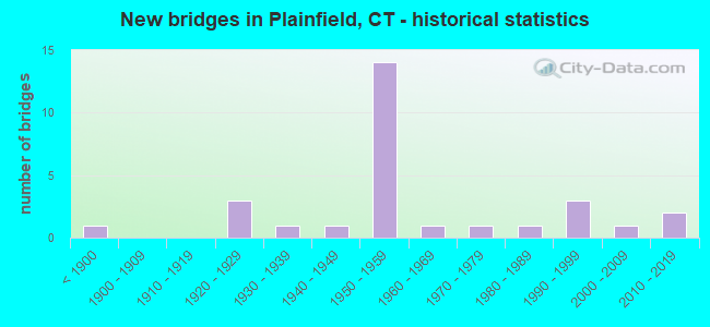
- New bridges - historical statistics
- 1Before 1900
- 31920-1929
- 11930-1939
- 11940-1949
- 141950-1959
- 11960-1969
- 11970-1979
- 11980-1989
- 31990-1999
- 12000-2009
- 22010-2019

- Reconstructed bridges - Historical Statistics
- 11960-1969
- 01970-1979
- 61980-1989
- 31990-1999
- 22000-2009
- 12010-2019


- Bridge Condition - Deck
- 14.3%Very good
- 52.4%Good
- 19.0%Satisfactory
- 9.5%Fair
- 4.8%Poor

- Bridge Condition - Superstructure
- 13.6%Very good
- 40.9%Good
- 27.3%Satisfactory
- 13.6%Fair
- 4.5%Poor

- Bridge Condition - Substructure
- 18.2%Very good
- 45.5%Good
- 36.4%Satisfactory

- Bridge Condition - Channel
- 17.6%Very good
- 58.8%Good
- 23.5%Satisfactory

- Bridge Condition - Culverts
- 33.3%Very good
- 66.7%Good
Find on map >> Show street view
Structure Number: 295, Location: 3 MILES NORTH OF ROUTE201 (Lat: 41.656228, Lng: -71.923986), Route carried "on" structure: Interstate 395, Year Built: 1958, Year Reconstructed: 1987, Status: Open, Structure Length: 3.77m (12.37ft), Average Daily Traffic: 30,000 (year 2020), Truck Traffic: 16%, Average Future Daily Traffic: 44,577 (year 2040), Design Load: HS 20, Features Intersected: KATE DOWNING ROAD
Minimum Vertical Clearance: 30+ m (98+ ft), Kilometerpoint: 44.176, Lanes on structure: 4, Lanes under structure: 2, Base Highway Network: Yes, Owner: State Highway Agency, Approaching Roadway Width: 23.1m (75.8ft), Skew: 1 degrees, Material/Design: Steel, Design/Construction: Stringer/Multi-beam, Number Of Spans In Main Unit: 3, Length of Maximum Span: 16.2m (53.1ft), Curb-To-Curb Width: 23.1m (75.8ft), Out-to-Out Width: 31.6m (103.7ft)
Condition: Deck: Good, Superstructure: Satisfactory, Substructure: Good, Operating Rating: 61.2 metric tons, Method Used To Determine Operating Rating: Load and Resistance Factor Rating (LRFR) rating reported by rating factor(RF) method using HL-93 loadings, Inventory Rating: 47.3 metric tons, Method Used To Determine Inventory Rating: Load and Resistance Factor Rating (LRFR) rating reported by rating factor(RF) method using HL-93 loadings, Structural Evaluation: Equal to present minimum criteria, Deck Geometry: Superior to present desirable criteria, Underclear: Meets minimum limits, Approach Roadway Alignment: Equal to present desirable criteria, Designated Inspection Frequency: Every 24 months, Inspection Date: Febuary 2022, Deck Structure Type: Concrete Cast-file-Place, Wearing Surface/Protective System: Wearing Surface: Bituminous, Membrane: Preformed Fabric, Deck Protection: Epoxy Coated Reinforcing
Find on map >> Show street view
Structure Number: 296, Location: 4 MILE NORTH OF ROUTE 201 (Lat: 41.662050, Lng: -71.917778), Route carried "on" structure: Interstate 395, Year Built: 1958, Status: Open, Structure Length: 0.64m (2.10ft), Average Daily Traffic: 30,700 (year 2008), Truck Traffic: 10%, Average Future Daily Traffic: 45,617 (year 2028), Design Load: H 20, Features Intersected: MILL BROOK
Minimum Vertical Clearance: 30+ m (98+ ft), Kilometerpoint: 45.013, Lanes on structure: 4, Base Highway Network: Yes, Owner: State Highway Agency, Approaching Roadway Width: 30.8m (101.0ft), Material/Design: Concrete continuous, Design/Construction: Culvert, Number Of Spans In Main Unit: 2, Length of Maximum Span: 3.0m (9.8ft)
Condition: Channel: Good, Culverts: Good, Structural Evaluation: Better than present minimum criteria, Waterway Adequacy: Equal to present desirable criteria, Approach Roadway Alignment: Equal to present desirable criteria, Designated Inspection Frequency: Every 48 months, Inspection Date: December 2018
Find on map >> Show street view
Structure Number: 298, Location: 1 MI SOUTH OF ROUTE 14A (Lat: 41.669314, Lng: -71.910811), Route carried "on" structure: Interstate 395, Year Built: 1958, Year Reconstructed: 2001, Status: Open, Structure Length: 3.84m (12.60ft), Average Daily Traffic: 28,600 (year 2020), Truck Traffic: 10%, Average Future Daily Traffic: 42,497 (year 2040), Design Load: HS 20, Features Intersected: DOW ROAD
Minimum Vertical Clearance: 30+ m (98+ ft), Kilometerpoint: 45.995, Lanes on structure: 4, Lanes under structure: 2, Base Highway Network: Yes, Owner: State Highway Agency, Approaching Roadway Width: 23.5m (77.1ft), Skew: 32 degrees, Material/Design: Steel, Design/Construction: Stringer/Multi-beam, Number Of Spans In Main Unit: 3, Length of Maximum Span: 13.7m (44.9ft), Curb-To-Curb Width: 30.2m (99.1ft), Out-to-Out Width: 31.6m (103.7ft)
Condition: Deck: Good, Superstructure: Satisfactory, Substructure: Satisfactory, Operating Rating: 76.5 metric tons, Method Used To Determine Operating Rating: Load and Resistance Factor Rating (LRFR) rating reported by rating factor(RF) method using HL-93 loadings, Inventory Rating: 59.0 metric tons, Method Used To Determine Inventory Rating: Load and Resistance Factor Rating (LRFR) rating reported by rating factor(RF) method using HL-93 loadings, Structural Evaluation: Equal to present minimum criteria, Deck Geometry: Superior to present desirable criteria, Underclear: Meets minimum limits, Approach Roadway Alignment: Equal to present desirable criteria, Designated Inspection Frequency: Every 24 months, Inspection Date: Febuary 2022, Deck Structure Type: Concrete Cast-file-Place, Wearing Surface/Protective System: Wearing Surface: Bituminous, Membrane: Built-up, Deck Protection: Epoxy Coated Reinforcing
Find on map >> Show street view
Structure Number: 3, Location: .5 MI SOUTH JCT ROUTE 14 (Lat: 41.709183, Lng: -71.897883), Route carried "on" structure: Interstate 395, Year Built: 1958, Status: Open, Structure Length: 1.25m (4.10ft), Average Daily Traffic: 30,000 (year 2017), Truck Traffic: 10%, Average Future Daily Traffic: 44,577 (year 2037), Design Load: HS 20, Features Intersected: ABANDONED RAILROAD
Minimum Vertical Clearance: 30+ m (98+ ft), Kilometerpoint: 50.614, Lanes on structure: 4, Base Highway Network: Yes, Owner: State Highway Agency, Approaching Roadway Width: 30.5m (100.1ft), Skew: 24 degrees, Material/Design: Steel, Design/Construction: Stringer/Multi-beam, Number Of Spans In Main Unit: 1, Length of Maximum Span: 11.0m (36.1ft), Curb-To-Curb Width: 30.5m (100.1ft), Out-to-Out Width: 31.6m (103.7ft)
Condition: Deck: Good, Superstructure: Good, Substructure: Good, Operating Rating: 59.8 metric tons, Method Used To Determine Operating Rating: Load Factor (LF), Inventory Rating: 35.8 metric tons, Method Used To Determine Inventory Rating: Load Factor (LF), Structural Evaluation: Better than present minimum criteria, Deck Geometry: Superior to present desirable criteria, Approach Roadway Alignment: Equal to present desirable criteria, Designated Inspection Frequency: Every 24 months, Inspection Date: April 2021, Deck Structure Type: Concrete Cast-file-Place, Wearing Surface/Protective System: Wearing Surface: Bituminous, Membrane: Built-up
Find on map >> Show street view
Structure Number: 301, Location: .5 MI SOUTH OF ROUTE 14 (Lat: 41.710183, Lng: -71.897414), Route carried "on" structure: Interstate 395, Year Built: 1958, Year Reconstructed: 1985, Status: Open, Structure Length: 3.70m (12.14ft), Average Daily Traffic: 30,000 (year 2017), Truck Traffic: 16%, Average Future Daily Traffic: 44,577 (year 2037), Design Load: HS 20, Features Intersected: PLAINFIELD ROAD
Minimum Vertical Clearance: 30+ m (98+ ft), Kilometerpoint: 50.710, Lanes on structure: 4, Lanes under structure: 2, Base Highway Network: Yes, Owner: State Highway Agency, Approaching Roadway Width: 22.9m (75.1ft), Skew: 30 degrees, Material/Design: Steel, Design/Construction: Stringer/Multi-beam, Number Of Spans In Main Unit: 3, Length of Maximum Span: 13.4m (44.0ft), Curb-To-Curb Width: 23.1m (75.8ft), Out-to-Out Width: 31.6m (103.7ft)
Condition: Deck: Satisfactory, Superstructure: Satisfactory, Substructure: Satisfactory, Operating Rating: 41.5 metric tons, Method Used To Determine Operating Rating: Load and Resistance Factor Rating (LRFR) rating reported by rating factor(RF) method using HL-93 loadings, Inventory Rating: 31.8 metric tons, Method Used To Determine Inventory Rating: Load and Resistance Factor Rating (LRFR) rating reported by rating factor(RF) method using HL-93 loadings, Structural Evaluation: Equal to present minimum criteria, Deck Geometry: Superior to present desirable criteria, Underclear: Meets minimum limits, Approach Roadway Alignment: Equal to present desirable criteria, Designated Inspection Frequency: Every 24 months, Inspection Date: June 2021, Deck Structure Type: Concrete Cast-file-Place, Wearing Surface/Protective System: Wearing Surface: Bituminous, Membrane: Preformed Fabric
Find on map >> Show street view
Structure Number: 302, Location: 2.4 MI NORTH OF ROUTE 14A (Lat: 41.717592, Lng: -71.894822), Route carried "on" structure: Interstate 395, Year Built: 1958, Year Reconstructed: 1988, Status: Open, Structure Length: 11.34m (37.20ft), Average Daily Traffic: 30,400 (year 2017), Truck Traffic: 14%, Average Future Daily Traffic: 45,171 (year 2037), Design Load: HS 20, Features Intersected: MOOSUP RIVER & ROUTE 14
Minimum Vertical Clearance: 30+ m (98+ ft), Kilometerpoint: 51.515, Lanes on structure: 4, Lanes under structure: 4, Base Highway Network: Yes, Owner: State Highway Agency, Approaching Roadway Width: 22.9m (75.1ft), Skew: 24 degrees, Material/Design: Steel, Design/Construction: Stringer/Multi-beam, Number Of Spans In Main Unit: 4, Length of Maximum Span: 27.4m (89.9ft), Curb-To-Curb Width: 22.8m (74.8ft), Out-to-Out Width: 31.6m (103.7ft)
Condition: Deck: Poor, Superstructure: Fair, Substructure: Satisfactory, Channel: Satisfactory, Operating Rating: 14.3 metric tons, Method Used To Determine Operating Rating: Load and Resistance Factor Rating (LRFR) rating reported by rating factor(RF) method using HL-93 loadings, Inventory Rating: 8.7 metric tons, Method Used To Determine Inventory Rating: Load and Resistance Factor Rating (LRFR) rating reported by rating factor(RF) method using HL-93 loadings, Structural Evaluation: High priority of corrective action, Deck Geometry: Superior to present desirable criteria, Underclear: High priority of corrective action, Waterway Adequacy: Equal to present desirable criteria, Approach Roadway Alignment: Equal to present desirable criteria, Designated Inspection Frequency: Every 24 months, Inspection Date: January 2020, Total Project Cost: $11,400,000 ( Estimate for 2015), Deck Structure Type: Concrete Cast-file-Place, Wearing Surface/Protective System: Wearing Surface: Bituminous, Membrane: Preformed Fabric, Deck Protection: Epoxy Coated Reinforcing
Find on map >> Show street view
Structure Number: 303, Location: 1.3 M NORTH OF ROUTE 14 (Lat: 41.734772, Lng: -71.883608), Route carried "on" structure: City street , Year Built: 1958, Year Reconstructed: 2013, Status: Open, Structure Length: 5.00m (16.40ft), Average Daily Traffic: 1,700 (year 2019), Truck Traffic: 7%, Average Future Daily Traffic: 2,526 (year 2039), Design Load: HS 20, Features Intersected: INTERSTATE-395, Facility Carried by Structure: MOOSUP POND ROAD
Minimum Vertical Clearance: 30+ m (98+ ft), Kilometerpoint: 53.720, Lanes on structure: 2, Lanes under structure: 4, Owner: State Highway Agency, Approaching Roadway Width: 12.8m (42.0ft), Skew: 1 degrees, Material/Design: Steel, Design/Construction: Stringer/Multi-beam, Number Of Spans In Main Unit: 2, Length of Maximum Span: 24.1m (79.1ft), Curb-To-Curb Width: 12.8m (42.0ft), Out-to-Out Width: 13.9m (45.6ft)
Condition: Deck: Satisfactory, Superstructure: Satisfactory, Substructure: Satisfactory, Operating Rating: 61.2 metric tons, Method Used To Determine Operating Rating: Load and Resistance Factor Rating (LRFR) rating reported by rating factor(RF) method using HL-93 loadings, Inventory Rating: 47.3 metric tons, Method Used To Determine Inventory Rating: Load and Resistance Factor Rating (LRFR) rating reported by rating factor(RF) method using HL-93 loadings, Structural Evaluation: Equal to present minimum criteria, Deck Geometry: Better than present minimum criteria, Underclear: High priority of corrective action, Approach Roadway Alignment: Equal to present minimum criteria, Designated Inspection Frequency: Every 24 months, Inspection Date: November 2021, Deck Structure Type: Concrete Cast-file-Place, Wearing Surface/Protective System: Wearing Surface: Bituminous, Membrane: Preformed Fabric
Find on map >> Show street view
Structure Number: 304, Location: 2 MILES NORTH OF ROUTE 14 (Lat: 41.744581, Lng: -71.879461), Route carried "on" structure: Interstate 395, Year Built: 1958, Year Reconstructed: 1987, Status: Open, Structure Length: 3.69m (12.11ft), Average Daily Traffic: 29,100 (year 2017), Truck Traffic: 10%, Average Future Daily Traffic: 43,240 (year 2037), Design Load: HS 20, Features Intersected: ROPER ROAD
Minimum Vertical Clearance: 30+ m (98+ ft), Kilometerpoint: 54.879, Lanes on structure: 4, Lanes under structure: 2, Base Highway Network: Yes, Owner: State Highway Agency, Approaching Roadway Width: 22.8m (74.8ft), Skew: 20 degrees, Material/Design: Steel, Design/Construction: Stringer/Multi-beam, Number Of Spans In Main Unit: 3, Length of Maximum Span: 12.9m (42.3ft), Curb-To-Curb Width: 30.1m (98.8ft), Out-to-Out Width: 31.6m (103.7ft)
Condition: Deck: Good, Superstructure: Satisfactory, Substructure: Satisfactory, Operating Rating: 60.3 metric tons, Method Used To Determine Operating Rating: Load and Resistance Factor Rating (LRFR) rating reported by rating factor(RF) method using HL-93 loadings, Inventory Rating: 46.3 metric tons, Method Used To Determine Inventory Rating: Load and Resistance Factor Rating (LRFR) rating reported by rating factor(RF) method using HL-93 loadings, Structural Evaluation: Equal to present minimum criteria, Deck Geometry: Superior to present desirable criteria, Underclear: Meets minimum limits, Approach Roadway Alignment: Equal to present desirable criteria, Designated Inspection Frequency: Every 24 months, Inspection Date: December 2020, Deck Structure Type: Concrete Cast-file-Place, Wearing Surface/Protective System: Wearing Surface: Bituminous, Membrane: Preformed Fabric, Deck Protection: Epoxy Coated Reinforcing
Find on map >> Show street view
Structure Number: 668, Location: 1.6 MI S OF ROUTE 14A EB (Lat: 41.664242, Lng: -71.919875), Route carried "on" structure: State highway 12, Year Built: 1920, Year Reconstructed: 2018, Status: Open, Structure Length: 0.85m (2.79ft), Average Daily Traffic: 6,000 (year 2016), Truck Traffic: 3%, Average Future Daily Traffic: 8,915 (year 2036), Design Load: HL 93, Features Intersected: MILL BROOK
Minimum Vertical Clearance: 30+ m (98+ ft), Kilometerpoint: 42.310, Lanes on structure: 2, Owner: State Highway Agency, Approaching Roadway Width: 8.2m (26.9ft), Skew: 3 degrees, Material/Design: Concrete, Design/Construction: Slab, Number Of Spans In Main Unit: 1, Length of Maximum Span: 7.3m (24.0ft), Curb-To-Curb Width: 16.8m (55.1ft), Out-to-Out Width: 20.2m (66.3ft)
Condition: Deck: Very good, Superstructure: Very good, Substructure: Good, Channel: Satisfactory, Operating Rating: 97.2 metric tons, Method Used To Determine Operating Rating: Load and Resistance Factor Rating (LRFR) rating reported by rating factor(RF) method using HL-93 loadings, Inventory Rating: 97.2 metric tons, Method Used To Determine Inventory Rating: Load and Resistance Factor Rating (LRFR) rating reported by rating factor(RF) method using HL-93 loadings, Structural Evaluation: Better than present minimum criteria, Deck Geometry: Superior to present desirable criteria, Waterway Adequacy: Equal to present minimum criteria, Approach Roadway Alignment: Equal to present desirable criteria, Designated Inspection Frequency: Every 24 months, Inspection Date: October 2020, Deck Structure Type: Concrete Cast-file-Place, Wearing Surface/Protective System: Wearing Surface: Bituminous, Membrane: Other, Deck Protection: Epoxy Coated Reinforcing
Find on map >> Show street view
Structure Number: 685, Location: 0.5 MI WEST OF ROUTE 12 (Lat: 41.720372, Lng: -71.915808), Route carried "on" structure: State highway 14, Year Built: 1962, Year Reconstructed: 1992, Status: Open, Structure Length: 2.59m (8.50ft), Average Daily Traffic: 3,700 (year 2016), Truck Traffic: 2%, Average Future Daily Traffic: 5,498 (year 2036), Design Load: HS 20, Features Intersected: MOOSUP RIVER
Minimum Vertical Clearance: 30+ m (98+ ft), Kilometerpoint: 26.490, Lanes on structure: 2, Owner: State Highway Agency, Approaching Roadway Width: 12.8m (42.0ft), Material/Design: Steel, Design/Construction: Stringer/Multi-beam, Number Of Spans In Main Unit: 1, Length of Maximum Span: 24.4m (80.1ft), Curb-To-Curb Width: 12.8m (42.0ft), Out-to-Out Width: 13.9m (45.6ft)
Condition: Deck: Good, Superstructure: Good, Substructure: Good, Channel: Satisfactory, Operating Rating: 72.6 metric tons, Method Used To Determine Operating Rating: Load and Resistance Factor Rating (LRFR) rating reported by rating factor(RF) method using HL-93 loadings, Inventory Rating: 55.7 metric tons, Method Used To Determine Inventory Rating: Load and Resistance Factor Rating (LRFR) rating reported by rating factor(RF) method using HL-93 loadings, Structural Evaluation: Better than present minimum criteria, Deck Geometry: Equal to present minimum criteria, Waterway Adequacy: Equal to present minimum criteria, Approach Roadway Alignment: Equal to present desirable criteria, Designated Inspection Frequency: Every 24 months, Inspection Date: April 2021, Deck Structure Type: Concrete Cast-file-Place, Wearing Surface/Protective System: Wearing Surface: Bituminous, Membrane: Preformed Fabric, Deck Protection: Epoxy Coated Reinforcing
Find on map >> Show street view
Structure Number: 686, Location: 0.1 MI WEST OF GOSHEN RD (Lat: 41.719431, Lng: -71.859178), Route carried "on" structure: State highway 14, Year Built: 1940, Year Reconstructed: 1988, Status: Open, Structure Length: 14.78m (48.49ft), Average Daily Traffic: 2,700 (year 2016), Truck Traffic: 15%, Average Future Daily Traffic: 4,012 (year 2036), Design Load: HS 20, Features Intersected: MOOSUP RIVER
Minimum Vertical Clearance: 30+ m (98+ ft), Kilometerpoint: 32.187, Lanes on structure: 2, Base Highway Network: Yes, Owner: State Highway Agency, Approaching Roadway Width: 9.1m (29.9ft), Material/Design: Steel continuous, Design/Construction: Stringer/Multi-beam, Number Of Spans In Main Unit: 4, Length of Maximum Span: 48.8m (160.1ft), Curb or Sidewalk Widths: Left: 0.2m (0.7ft), Right: 0.2m (0.7ft), Curb-To-Curb Width: 9.1m (29.9ft), Out-to-Out Width: 10.9m (35.8ft)
Condition: Deck: Fair, Superstructure: Fair, Substructure: Satisfactory, Channel: Good, Operating Rating: 15.9 metric tons, Method Used To Determine Operating Rating: Load and Resistance Factor Rating (LRFR) rating reported by rating factor(RF) method using HL-93 loadings, Inventory Rating: 12.3 metric tons, Method Used To Determine Inventory Rating: Load and Resistance Factor Rating (LRFR) rating reported by rating factor(RF) method using HL-93 loadings, Structural Evaluation: High priority of corrective action, Deck Geometry: Meets minimum limits, Waterway Adequacy: Better than present minimum criteria, Approach Roadway Alignment: Equal to present desirable criteria, Designated Inspection Frequency: Every 24 months, Inspection Date: May 2020, Deck Structure Type: Concrete Cast-file-Place, Wearing Surface/Protective System: Wearing Surface: Bituminous, Membrane: Preformed Fabric
Find on map >> Show street view
Structure Number: 1647, Location: 3 MI NORTH OF ROUTE 14 (Lat: 41.759044, Lng: -71.850747), Route carried "on" structure: Alternate State highway 664, Year Built: 1925, Year Reconstructed: 1972, Status: Open, Structure Length: 0.85m (2.79ft), Average Daily Traffic: 600 (year 2016), Truck Traffic: 2%, Average Future Daily Traffic: 892 (year 2036), Design Load: HS 20, Features Intersected: SNAKE MEADOW BROOK
Minimum Vertical Clearance: 30+ m (98+ ft), Kilometerpoint: 5.263, Lanes on structure: 2, Owner: State Highway Agency, Approaching Roadway Width: 5.8m (19.0ft), Skew: 2 degrees, Material/Design: Steel, Design/Construction: Stringer/Multi-beam, Number Of Spans In Main Unit: 1, Length of Maximum Span: 6.4m (21.0ft), Curb-To-Curb Width: 5.9m (19.4ft), Out-to-Out Width: 6.1m (20.0ft)
Condition: Deck: Satisfactory, Superstructure: Poor, Substructure: Satisfactory, Channel: Good, Operating Rating: 94.4 metric tons, Method Used To Determine Operating Rating: Load Factor (LF), Inventory Rating: 56.6 metric tons, Method Used To Determine Inventory Rating: Load Factor (LF), Structural Evaluation: Meets minimum limits, Deck Geometry: High priority of replacement, Waterway Adequacy: Equal to present minimum criteria, Approach Roadway Alignment: Equal to present desirable criteria, Designated Inspection Frequency: Every 24 months, Inspection Date: April 2021, Total Project Cost: $3,800,000, Deck Structure Type: Corrugated Steel, Wearing Surface/Protective System: Wearing Surface: Bituminous
Find on map >> Show street view
Structure Number: 2986, Location: .1 MI S OF LATHROP RD (Lat: 41.663433, Lng: -71.916228), Route carried "on" structure: Interstate 395, Year Built: 1958, Status: Open, Structure Length: 0.64m (2.10ft), Average Daily Traffic: 27,900 (year 2017), Truck Traffic: 10%, Average Future Daily Traffic: 41,457 (year 2037), Design Load: H 20, Features Intersected: LATHROP BROOK
Minimum Vertical Clearance: 30+ m (98+ ft), Kilometerpoint: 45.062, Lanes on structure: 6, Base Highway Network: Yes, Owner: State Highway Agency, Approaching Roadway Width: 29.9m (98.1ft), Skew: 4 degrees, Material/Design: Concrete continuous, Design/Construction: Culvert, Number Of Spans In Main Unit: 2, Length of Maximum Span: 3.0m (9.8ft)
Condition: Channel: Satisfactory, Culverts: Good, Structural Evaluation: Better than present minimum criteria, Waterway Adequacy: Equal to present minimum criteria, Approach Roadway Alignment: Equal to present desirable criteria, Designated Inspection Frequency: Every 24 months, Inspection Date: December 2020
Find on map >> Show street view
Structure Number: 4076, Location: 3.8 MILES N OF ROUTE 201 (Lat: 41.647606, Lng: -71.935764), Route carried "on" structure: State highway 12, Year Built: 1977, Status: Open, Structure Length: 1.31m (4.30ft), Average Daily Traffic: 3,600 (year 2016), Truck Traffic: 3%, Average Future Daily Traffic: 5,349 (year 2036), Design Load: HS 20, Features Intersected: PROV & WORC RAILROAD
Minimum Vertical Clearance: 30+ m (98+ ft), Kilometerpoint: 39.976, Lanes on structure: 2, Owner: State Highway Agency, Approaching Roadway Width: 13.4m (44.0ft), Material/Design: Prestressed concrete, Design/Construction: Arch - Deck, Number Of Spans In Main Unit: 1, Length of Maximum Span: 13.1m (43.0ft), Curb-To-Curb Width: 13.4m (44.0ft), Out-to-Out Width: 71.3m (233.9ft)
Condition: Superstructure: Good, Substructure: Good, Inventory Rating: 72.5 metric tons, Method Used To Determine Inventory Rating: Load Factor (LF), Structural Evaluation: Better than present minimum criteria, Deck Geometry: Better than present minimum criteria, Underclear: Better than present minimum criteria, Approach Roadway Alignment: Equal to present desirable criteria, Designated Inspection Frequency: Every 48 months, Inspection Date: January 2022, Wearing Surface/Protective System: Wearing Surface: Bituminous
Find on map >> Show street view
Structure Number: 4403, Location: 300' E. of Rt. 14 (Lat: 41.714761, Lng: -71.879286), Route carried "on" structure: City street , Year Built: 2001, Status: Open, Structure Length: 3.34m (10.96ft), Average Daily Traffic: 3,100 (year 2020), Truck Traffic: 7%, Average Future Daily Traffic: 4,606 (year 2040), Design Load: HS 20, Features Intersected: MOOSUP RIVER, Facility Carried by Structure: RIVER STREET NO 1
Minimum Vertical Clearance: 30+ m (98+ ft), Kilometerpoint: 0.000, Lanes on structure: 2, Owner: Town or Township Highway Agency, Approaching Roadway Width: 7.0m (23.0ft), Material/Design: Steel, Design/Construction: Stringer/Multi-beam, Number Of Spans In Main Unit: 1, Length of Maximum Span: 32.0m (105.0ft), Curb or Sidewalk Widths: Left: 0.0m, Right: 1.5m (4.9ft), Curb-To-Curb Width: 7.2m (23.6ft), Out-to-Out Width: 9.5m (31.2ft)
Condition: Deck: Good, Superstructure: Good, Substructure: Good, Channel: Very good, Operating Rating: 90.0 metric tons, Method Used To Determine Operating Rating: Load Factor (LF), Inventory Rating: 54.0 metric tons, Method Used To Determine Inventory Rating: Load Factor (LF), Structural Evaluation: Better than present minimum criteria, Waterway Adequacy: Equal to present desirable criteria, Approach Roadway Alignment: High priority of corrective action, Designated Inspection Frequency: Every 24 months, Inspection Date: May 2020, Deck Structure Type: Concrete Cast-file-Place, Wearing Surface/Protective System: Wearing Surface: Bituminous, Membrane: Preformed Fabric, Deck Protection: Epoxy Coated Reinforcing
Find on map >> Show street view
Structure Number: 4405, Location: 0.1 MI SOUTH OF ROUTE 14 (Lat: 41.721400, Lng: -71.907978), Route carried "on" structure: City street , Year Built: 1997, Status: Open, Structure Length: 2.62m (8.60ft), Average Daily Traffic: 1,491 (year 2014), Truck Traffic: 7%, Average Future Daily Traffic: 2,215 (year 2034), Design Load: HS 20, Features Intersected: MOOSUP RIVER, Facility Carried by Structure: WATER STREET
Minimum Vertical Clearance: 30+ m (98+ ft), Kilometerpoint: 0.016, Lanes on structure: 2, Owner: Town or Township Highway Agency, Approaching Roadway Width: 7.3m (24.0ft), Skew: 2 degrees, Material/Design: Prestressed concrete, Design/Construction: Box Beam or Girders - Multiple, Number Of Spans In Main Unit: 1, Length of Maximum Span: 24.7m (81.0ft), Curb or Sidewalk Widths: Left: 0.0m, Right: 1.8m (5.9ft), Curb-To-Curb Width: 7.3m (24.0ft), Out-to-Out Width: 10.2m (33.5ft)
Condition: Deck: Good, Superstructure: Good, Substructure: Good, Channel: Good, Operating Rating: 65.2 metric tons, Method Used To Determine Operating Rating: Load Factor (LF), Inventory Rating: 33.6 metric tons, Method Used To Determine Inventory Rating: Load Factor (LF), Structural Evaluation: Better than present minimum criteria, Deck Geometry: Meets minimum limits, Waterway Adequacy: Equal to present desirable criteria, Approach Roadway Alignment: Equal to present minimum criteria, Designated Inspection Frequency: Every 24 months, Inspection Date: May 2020, Deck Structure Type: Other, Wearing Surface/Protective System: Wearing Surface: Bituminous, Membrane: Built-up, Deck Protection: Epoxy Coated Reinforcing
Find on map >> Show street view
Structure Number: 475, Location: 2000' WEST OF ROUTE 14 (Lat: 41.708892, Lng: -71.884808), Route carried "on" structure: City street , Year Built: 1997, Status: Open, Structure Length: 2.26m (7.41ft), Average Daily Traffic: 2,433 (year 2020), Truck Traffic: 2%, Average Future Daily Traffic: 3,615 (year 2040), Design Load: HS 20, Features Intersected: MOOSUP RIVER, Facility Carried by Structure: SOUTH MAIN STREET
Minimum Vertical Clearance: 30+ m (98+ ft), Kilometerpoint: 0.097, Lanes on structure: 2, Owner: Town or Township Highway Agency, Approaching Roadway Width: 8.5m (27.9ft), Skew: 1 degrees, Material/Design: Prestressed concrete, Design/Construction: Box Beam or Girders - Multiple, Number Of Spans In Main Unit: 1, Length of Maximum Span: 21.0m (68.9ft), Curb or Sidewalk Widths: Left: 1.8m (5.9ft), Right: 0.0m, Curb-To-Curb Width: 8.5m (27.9ft), Out-to-Out Width: 11.4m (37.4ft)
Condition: Deck: Good, Superstructure: Good, Substructure: Very good, Channel: Good, Operating Rating: 59.9 metric tons, Method Used To Determine Operating Rating: Load Factor (LF), Inventory Rating: 35.4 metric tons, Method Used To Determine Inventory Rating: Load Factor (LF), Structural Evaluation: Better than present minimum criteria, Deck Geometry: Meets minimum limits, Waterway Adequacy: Better than present minimum criteria, Approach Roadway Alignment: Equal to present minimum criteria, Designated Inspection Frequency: Every 24 months, Inspection Date: May 2020, Deck Structure Type: Other, Wearing Surface/Protective System: Wearing Surface: Bituminous, Membrane: Built-up, Deck Protection: Epoxy Coated Reinforcing
Find on map >> Show street view
Structure Number: 4751, Location: 575 FT EAST OF GENDRON RD (Lat: 41.707142, Lng: -71.877439), Route carried "on" structure: City street , Year Built: 2012, Status: Open, Structure Length: 1.43m (4.69ft), Average Daily Traffic: 1,331 (year 2020), Truck Traffic: 7%, Average Future Daily Traffic: 1,978 (year 2040), Design Load: HL 93, Features Intersected: EKONK BROOK, Facility Carried by Structure: STERLING HILL ROAD
Minimum Vertical Clearance: 30+ m (98+ ft), Kilometerpoint: 2.269, Lanes on structure: 2, Owner: Town or Township Highway Agency, Approaching Roadway Width: 7.3m (24.0ft), Skew: 2 degrees, Material/Design: Concrete, Design/Construction: Frame, Number Of Spans In Main Unit: 1, Length of Maximum Span: 13.1m (43.0ft), Curb-To-Curb Width: 7.3m (24.0ft), Out-to-Out Width: 8.4m (27.6ft)
Condition: Deck: Satisfactory, Superstructure: Satisfactory, Substructure: Very good, Channel: Good, Operating Rating: 57.0 metric tons, Method Used To Determine Operating Rating: Load and Resistance Factor Rating (LRFR) rating reported by rating factor(RF) method using HL-93 loadings, Inventory Rating: 44.1 metric tons, Method Used To Determine Inventory Rating: Load and Resistance Factor Rating (LRFR) rating reported by rating factor(RF) method using HL-93 loadings, Structural Evaluation: Equal to present minimum criteria, Deck Geometry: Meets minimum limits, Waterway Adequacy: Superior to present desirable criteria, Approach Roadway Alignment: Equal to present desirable criteria, Designated Inspection Frequency: Every 24 months, Inspection Date: May 2020, Deck Structure Type: Other, Wearing Surface/Protective System: Wearing Surface: Bituminous, Membrane: Built-up, Deck Protection: Epoxy Coated Reinforcing
Find on map >> Show street view
Structure Number: 4754, Location: 1.5 MI SOUTH OF ROUTE 14A (Lat: 41.667136, Lng: -71.948358), Route carried "on" structure: City street , Year Built: 1850, Year Reconstructed: 2003, Status: Open, Structure Length: 1.89m (6.20ft), Average Daily Traffic: 994 (year 2014), Truck Traffic: 7%, Average Future Daily Traffic: 1,477 (year 2034), Design Load: HS 20, Features Intersected: MILL BROOK, Facility Carried by Structure: PACKERVILLE ROAD
Minimum Vertical Clearance: 30+ m (98+ ft), Kilometerpoint: 2.559, Lanes on structure: 2, Owner: Town or Township Highway Agency, Approaching Roadway Width: 7.3m (24.0ft), Material/Design: Prestressed concrete, Design/Construction: Box Beam or Girders - Multiple, Number Of Spans In Main Unit: 1, Length of Maximum Span: 17.7m (58.1ft), Curb or Sidewalk Widths: Left: 0.0m, Right: 1.5m (4.9ft), Curb-To-Curb Width: 7.3m (24.0ft), Out-to-Out Width: 10.1m (33.1ft)
Condition: Deck: Very good, Superstructure: Very good, Substructure: Very good, Channel: Good, Operating Rating: 99.5 metric tons, Method Used To Determine Operating Rating: Load Factor (LF), Inventory Rating: 59.6 metric tons, Method Used To Determine Inventory Rating: Load Factor (LF), Structural Evaluation: Equal to present desirable criteria, Deck Geometry: Meets minimum limits, Waterway Adequacy: Equal to present minimum criteria, Approach Roadway Alignment: High priority of corrective action, Designated Inspection Frequency: Every 48 months, Inspection Date: May 2018, Deck Structure Type: Other, Wearing Surface/Protective System: Wearing Surface: Bituminous, Membrane: Built-up, Deck Protection: Epoxy Coated Reinforcing
Find on map >> Show street view
Structure Number: 4756, Location: 1000 FT SOUTH OF ROUTE 14 (Lat: 41.710011, Lng: -71.881789), Route carried "on" structure: City street , Year Built: 1950, Status: Open, Structure Length: 1.89m (6.20ft), Average Daily Traffic: 5,564 (year 2018), Truck Traffic: 2%, Average Future Daily Traffic: 8,268 (year 2038), Features Intersected: CANAL, Facility Carried by Structure: SOUTH MAIN STREET
Minimum Vertical Clearance: 30+ m (98+ ft), Kilometerpoint: 2.060, Lanes on structure: 2, Owner: Town or Township Highway Agency, Approaching Roadway Width: 7.3m (24.0ft), Skew: 3 degrees, Material/Design: Steel, Design/Construction: Stringer/Multi-beam, Number Of Spans In Main Unit: 2, Length of Maximum Span: 7.3m (24.0ft), Curb-To-Curb Width: 7.4m (24.3ft), Out-to-Out Width: 8.3m (27.2ft)
Condition: Deck: Fair, Superstructure: Fair, Substructure: Satisfactory, Channel: Good, Operating Rating: 51.2 metric tons, Method Used To Determine Operating Rating: Load and Resistance Factor Rating (LRFR) rating reported by rating factor(RF) method using HL-93 loadings, Inventory Rating: 39.5 metric tons, Method Used To Determine Inventory Rating: Load and Resistance Factor Rating (LRFR) rating reported by rating factor(RF) method using HL-93 loadings, Structural Evaluation: Somewhat better than minimum adequacy, Deck Geometry: High priority of replacement, Waterway Adequacy: Better than present minimum criteria, Approach Roadway Alignment: Somewhat better than minimum adequacy, Designated Inspection Frequency: Every 24 months, Underwater Inspection Frequency: Every 24 months, Inspection Date: May 2020, Underwater Inspection Date: May 2020, Deck Structure Type: Concrete Cast-file-Place, Wearing Surface/Protective System: Wearing Surface: Bituminous
Find on map >> Show street view
Structure Number: 4757, Location: 300 FT SOUTH OF ROUTE 14 (Lat: 41.717511, Lng: -71.868689), Route carried "on" structure: City street , Year Built: 1930, Year Reconstructed: 2001, Status: Open, Structure Length: 2.50m (8.20ft), Average Daily Traffic: 387 (year 2018), Truck Traffic: 7%, Average Future Daily Traffic: 575 (year 2038), Design Load: HS 20, Features Intersected: MOOSUP RIVER, Facility Carried by Structure: BARBER HILL ROAD
Minimum Vertical Clearance: 30+ m (98+ ft), Kilometerpoint: 3.444, Lanes on structure: 2, Owner: Town or Township Highway Agency, Approaching Roadway Width: 7.3m (24.0ft), Material/Design: Steel, Design/Construction: Stringer/Multi-beam, Number Of Spans In Main Unit: 1, Length of Maximum Span: 22.3m (73.2ft), Curb or Sidewalk Widths: Left: 1.5m (4.9ft), Right: 0.0m, Curb-To-Curb Width: 7.2m (23.6ft), Out-to-Out Width: 9.5m (31.2ft)
Condition: Deck: Very good, Superstructure: Very good, Substructure: Very good, Channel: Very good, Inventory Rating: 72.7 metric tons, Method Used To Determine Inventory Rating: Load Factor (LF), Structural Evaluation: Equal to present desirable criteria, Waterway Adequacy: Equal to present desirable criteria, Approach Roadway Alignment: Equal to present desirable criteria, Designated Inspection Frequency: Every 48 months, Inspection Date: May 2018, Deck Structure Type: Concrete Cast-file-Place, Wearing Surface/Protective System: Wearing Surface: Bituminous, Membrane: Preformed Fabric, Deck Protection: Epoxy Coated Reinforcing
Find on map >> Show street view
Structure Number: 4988, Location: 0.4 MI SOUTH OF ROUTE 14 (Lat: 41.708928, Lng: -71.882356), Route carried "on" structure: City street , Year Built: 1982, Status: Open, Structure Length: 2.50m (8.20ft), Average Daily Traffic: 3,370 (year 2018), Truck Traffic: 7%, Average Future Daily Traffic: 5,007 (year 2038), Features Intersected: MOOSUP RIVER, Facility Carried by Structure: POND STREET #1
Minimum Vertical Clearance: 30+ m (98+ ft), Kilometerpoint: 0.113, Lanes on structure: 2, Owner: Town or Township Highway Agency, Approaching Roadway Width: 9.1m (29.9ft), Material/Design: Prestressed concrete, Design/Construction: Box Beam or Girders - Multiple, Number Of Spans In Main Unit: 1, Length of Maximum Span: 23.8m (78.1ft), Curb or Sidewalk Widths: Left: 0.0m, Right: 1.7m (5.6ft), Curb-To-Curb Width: 9.2m (30.2ft), Out-to-Out Width: 11.8m (38.7ft)
Condition: Deck: Good, Superstructure: Good, Substructure: Good, Channel: Very good, Operating Rating: 42.6 metric tons, Method Used To Determine Operating Rating: Field evaluation and documented engineering judgment, Inventory Rating: 32.7 metric tons, Method Used To Determine Inventory Rating: Field evaluation and documented engineering judgment, Structural Evaluation: Better than present minimum criteria, Deck Geometry: Meets minimum limits, Waterway Adequacy: Better than present minimum criteria, Approach Roadway Alignment: Meets minimum limits, Designated Inspection Frequency: Every 48 months, Inspection Date: May 2018, Deck Structure Type: Other, Wearing Surface/Protective System: Wearing Surface: Bituminous, Membrane: Preformed Fabric
Find on map >> Show street view
Structure Number: 5665, Location: 0.1MI SO OF I-395 (Lat: 41.663664, Lng: -71.912839), Route carried "on" structure: City street , Year Built: 2017, Status: Open, Structure Length: 0.74m (2.43ft), Average Daily Traffic: 1,940 (year 2018), Truck Traffic: 3%, Average Future Daily Traffic: 2,883 (year 2038), Design Load: HL 93, Features Intersected: LATHROP BROOK, Facility Carried by Structure: LATHROP ROAD
Minimum Vertical Clearance: 30+ m (98+ ft), Kilometerpoint: 13.551, Lanes on structure: 4, Owner: Town or Township Highway Agency, Approaching Roadway Width: 16.2m (53.1ft), Material/Design: Concrete, Design/Construction: Culvert, Number Of Spans In Main Unit: 2, Length of Maximum Span: 3.7m (12.1ft)
Condition: Channel: Good, Culverts: Very good, Operating Rating: 46.7 metric tons, Method Used To Determine Operating Rating: Load and Resistance Factor Rating (LRFR) rating reported by rating factor(RF) method using HL-93 loadings, Inventory Rating: 36.0 metric tons, Method Used To Determine Inventory Rating: Load and Resistance Factor Rating (LRFR) rating reported by rating factor(RF) method using HL-93 loadings, Structural Evaluation: Equal to present desirable criteria, Waterway Adequacy: Somewhat better than minimum adequacy, Approach Roadway Alignment: Better than present minimum criteria, Designated Inspection Frequency: Every 24 months, Inspection Date: May 2020
Find on map >> Show street view
Structure Number: 6253, Location: .2 MILE SOUTH OF ROUTE 14 (Lat: 41.717556, Lng: -71.903278), Route carried "on" structure: State highway 12, Year Built: 1993, Status: Open, Structure Length: 2.59m (8.50ft), Average Daily Traffic: 6,300 (year 2016), Truck Traffic: 3%, Average Future Daily Traffic: 9,361 (year 2036), Design Load: H 15, Features Intersected: MOOSUP RIVER
Minimum Vertical Clearance: 30+ m (98+ ft), Kilometerpoint: 48.554, Lanes on structure: 2, Owner: State Highway Agency, Approaching Roadway Width: 9.1m (29.9ft), Skew: 3 degrees, Material/Design: Prestressed concrete, Design/Construction: Box Beam or Girders - Multiple, Number Of Spans In Main Unit: 1, Length of Maximum Span: 24.4m (80.1ft), Curb or Sidewalk Widths: Left: 0.0m, Right: 1.7m (5.6ft), Curb-To-Curb Width: 10.7m (35.1ft), Out-to-Out Width: 13.3m (43.6ft)
Condition: Deck: Good, Superstructure: Good, Substructure: Good, Channel: Good, Operating Rating: 76.2 metric tons, Method Used To Determine Operating Rating: Load Factor (LF), Inventory Rating: 37.2 metric tons, Method Used To Determine Inventory Rating: Load Factor (LF), Structural Evaluation: Better than present minimum criteria, Deck Geometry: Meets minimum limits, Waterway Adequacy: Equal to present desirable criteria, Approach Roadway Alignment: Equal to present desirable criteria, Designated Inspection Frequency: Every 48 months, Inspection Date: May 2021, Deck Structure Type: Other, Wearing Surface/Protective System: Wearing Surface: Bituminous, Membrane: Preformed Fabric, Deck Protection: Epoxy Coated Reinforcing
Find on map >> Show street view
Structure Number: 6553, Location: 0.1 MILE EAST OF RTE.14 (Lat: 41.714900, Lng: -71.879653), Route carried "on" structure: City street , Year Built: 1920, Year Reconstructed: 2000, Status: Open, Structure Length: 1.13m (3.71ft), Average Daily Traffic: 3,169 (year 2020), Average Future Daily Traffic: 4,709 (year 2040), Design Load: HS 20, Features Intersected: FACTORY TUNNEL, Facility Carried by Structure: RIVER STREET
Minimum Vertical Clearance: 30+ m (98+ ft), Kilometerpoint: 0.000, Lanes on structure: 2, Owner: Town or Township Highway Agency, Approaching Roadway Width: 6.7m (22.0ft), Material/Design: Prestressed concrete, Design/Construction: Stringer/Multi-beam, Number Of Spans In Main Unit: 1, Length of Maximum Span: 10.1m (33.1ft), Curb-To-Curb Width: 6.7m (22.0ft), Out-to-Out Width: 6.7m (22.0ft)
Condition: Deck: Good, Superstructure: Good, Substructure: Good, Operating Rating: 35.6 metric tons, Method Used To Determine Operating Rating: Load and Resistance Factor Rating (LRFR) rating reported by rating factor(RF) method using HL-93 loadings, Inventory Rating: 27.5 metric tons, Method Used To Determine Inventory Rating: Load and Resistance Factor Rating (LRFR) rating reported by rating factor(RF) method using HL-93 loadings, Structural Evaluation: Equal to present minimum criteria, Deck Geometry: High priority of replacement, Approach Roadway Alignment: Equal to present desirable criteria, Designated Inspection Frequency: Every 24 months, Inspection Date: May 2020, Deck Structure Type: Other, Wearing Surface/Protective System: Wearing Surface: Bituminous, Membrane: Preformed Fabric, Deck Protection: Epoxy Coated Reinforcing
Find on map >> Show street view
Structure Number: 297, Location: 3.7 MI NORTH OF ROUTE 201 (Lat: 41.665119, Lng: -71.914447), Route carried "under" structure: Alternate State highway 647, Year Built: 1958, Structure Length: 0. m, Average Daily Traffic: 9,700 (year 2016), Truck Traffic: 7%, Features Intersected: SR 647 (LATHROP ROAD), Facility Carried by Structure: INTERSTATE-395
Minimum Vertical Clearance: 4.55m (14.93ft), Kilometerpoint: 0.080, Lanes on structure: 4, Lanes under structure: 5, Material/Design: Steel, Design/Construction: Stringer/Multi-beam, Length of Maximum Span: 20.2m (66.3ft)
Find on map >> Show street view
Structure Number: 299, Location: OVER ROUTE 14A (Lat: 41.684558, Lng: -71.907922), Route carried "under" structure: State highway 14A, Year Built: 1958, Structure Length: 0. m, Average Daily Traffic: 6,900 (year 2019), Truck Traffic: 2%, Features Intersected: ROUTE 14A, Facility Carried by Structure: INTERSTATE-395
Minimum Vertical Clearance: 4.52m (14.83ft), Kilometerpoint: 5.826, Lanes on structure: 4, Lanes under structure: 2, Material/Design: Steel, Design/Construction: Stringer/Multi-beam, Length of Maximum Span: 13.7m (44.9ft)
Find on map >> Show street view
Structure Number: 302, Location: 2.4 MI NORTH OF ROUTE 14A (Lat: 41.717592, Lng: -71.894822), Route carried "under" structure: State highway 14, Year Built: 1958, Structure Length: 0. m, Average Daily Traffic: 10,400 (year 2016), Truck Traffic: 6%, Features Intersected: MOOSUP RIVER & ROUTE 14, Facility Carried by Structure: INTERSTATE-395
Minimum Vertical Clearance: 4.52m (14.83ft), Kilometerpoint: 28.598, Lanes on structure: 4, Lanes under structure: 4, Material/Design: Steel, Design/Construction: Stringer/Multi-beam, Length of Maximum Span: 27.4m (89.9ft)
Find on map >> Show street view
Structure Number: 303, Location: 1.3 M NORTH OF ROUTE 14 (Lat: 41.734772, Lng: -71.883608), Route carried "under" structure: Interstate 395, Year Built: 1958, Structure Length: 0. m, Average Daily Traffic: 27,700 (year 2020), Truck Traffic: 10%, Features Intersected: INTERSTATE-395, Facility Carried by Structure: MOOSUP POND ROAD
Minimum Vertical Clearance: 5.61m (18.41ft), Kilometerpoint: 53.720, Lanes on structure: 2, Lanes under structure: 4, Material/Design: Steel, Design/Construction: Stringer/Multi-beam, Length of Maximum Span: 24.1m (79.1ft)