Bridge Statistics for Penn Hills, Pennsylvania (PA)
Condition, Traffic, Stress, Structural Evaluation, Project Costs
- National Bridge Inventory (NBI) Statistics
- 10Number of bridges
- 92ft / 27.7mTotal length
- $4,587,000Total costs
- 219,097Total average daily traffic
- 15,885Total average daily truck traffic
- National Bridge Inventory (NBI) Registered Bridges for Penn Hills
- No street view available for this location
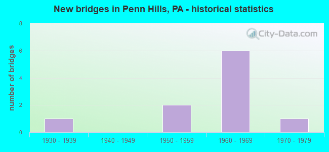
- New bridges - historical statistics
- 11930-1939
- 21950-1959
- 61960-1969
- 11970-1979


- Bridge Condition - Deck
- 66.7%Good
- 33.3%Satisfactory

- Bridge Condition - Superstructure
- 33.3%Good
- 66.7%Satisfactory

- Bridge Condition - Substructure
- 66.7%Good
- 33.3%Satisfactory

- Bridge Condition - Channel
- 40.0%Satisfactory
- 20.0%Fair
- 40.0%Poor

- Bridge Condition - Culverts
- 66.7%Satisfactory
- 33.3%Fair
Find on map >> Show street view
Structure Number: 948, Location: 200' NORTH OF SR 2058 (Lat: 40.476189, Lng: -79.848381), Route carried "on" structure: State highway 130, Year Built: 1950, Status: Open, Structure Length: 0.76m (2.49ft), Average Daily Traffic: 13,372 (year 2022), Truck Traffic: 3%, Average Future Daily Traffic: 16,468 (year 2032), Design Load: HS 20, Features Intersected: SANDY CREEK, Facility Carried by Structure: SANDY CREEK ROAD
Minimum Vertical Clearance: 30+ m (98+ ft), Kilometerpoint: 5.086, Lanes on structure: 4, Base Highway Network: Yes, Owner: State Highway Agency, Approaching Roadway Width: 16.5m (54.1ft), Skew: 1 degrees, Material/Design: Concrete, Design/Construction: Culvert, Number Of Spans In Main Unit: 1, Length of Maximum Span: 7.6m (24.9ft), Curb-To-Curb Width: 14.3m (46.9ft), Out-to-Out Width: 18.0m (59.1ft)
Condition: Channel: Poor, Culverts: Satisfactory, Operating Rating: 49.0 metric tons, Method Used To Determine Operating Rating: Field evaluation and documented engineering judgment, Inventory Rating: 32.7 metric tons, Method Used To Determine Inventory Rating: Field evaluation and documented engineering judgment, Structural Evaluation: Equal to present minimum criteria, Deck Geometry: High priority of replacement, Waterway Adequacy: Equal to present minimum criteria, Approach Roadway Alignment: Equal to present desirable criteria, Length Of Structure Improvement: 0.80m (2.62ft), Designated Inspection Frequency: Every 24 months, Inspection Date: September 2021
Find on map >> Show street view
Structure Number: 12, Location: 1 MI E OF RODI RD INTER (Lat: 40.442378, Lng: -79.819367), Route carried "on" structure: Interstate 376, Year Built: 1962, Year Reconstructed: 2010, Status: Open, Structure Length: 16.64m (54.59ft), Average Daily Traffic: 92,300 (year 2022), Truck Traffic: 8%, Average Future Daily Traffic: 64,685 (year 2032), Design Load: HS 20, Features Intersected: SUNSET DRIVE
Minimum Vertical Clearance: 30+ m (98+ ft), Kilometerpoint: 50.422, Lanes on structure: 6, Lanes under structure: 8, Base Highway Network: Yes, Owner: State Highway Agency, Approaching Roadway Width: 31.1m (102.0ft), Skew: 30 degrees, Material/Design: Steel continuous, Design/Construction: Girder and Floorbeam System, Number Of Spans In Main Unit: 3, Number Of Approach Spans: 2, Length of Maximum Span: 47.5m (155.8ft), Curb or Sidewalk Widths: Left: 0.2m (0.7ft), Right: 0.2m (0.7ft), Curb-To-Curb Width: 29.3m (96.1ft), Out-to-Out Width: 30.5m (100.1ft)
Condition: Deck: Good, Superstructure: Satisfactory, Substructure: Satisfactory, Channel: Satisfactory, Operating Rating: 49.0 metric tons, Method Used To Determine Operating Rating: Load Factor (LF), Inventory Rating: 29.0 metric tons, Method Used To Determine Inventory Rating: Load Factor (LF), Structural Evaluation: Equal to present minimum criteria, Deck Geometry: Better than present minimum criteria, Underclear: Superior to present desirable criteria, Waterway Adequacy: Superior to present desirable criteria, Approach Roadway Alignment: Equal to present desirable criteria, Length Of Structure Improvement: 17.50m (57.41ft), Designated Inspection Frequency: Every 24 months, Critical Feature Inspection Frequency: Every 24 months, Inspection Date: July 2021, Critical Feature Inspection Date: July 2021, Bridge Improvement Cost: $211,000, Roadway Improvement Cost: $622,000, Total Project Cost: $2,850,000, Deck Structure Type: Concrete Cast-file-Place, Wearing Surface/Protective System: Wearing Surface: Latex Concrete, Deck Protection: Epoxy Coated Reinforcing
Find on map >> Show street view
Structure Number: 1201, Location: JEFFERSON HTS.RD.O/I376 (Lat: 40.442850, Lng: -79.813789), Route carried "on" structure: State highway , Year Built: 1962, Year Reconstructed: 2010, Status: Open, Structure Length: 7.62m (25.00ft), Average Daily Traffic: 2,169 (year 2021), Truck Traffic: 5%, Average Future Daily Traffic: 3,752 (year 2032), Design Load: HS 20, Features Intersected: LR 187 PAR-I 376, Facility Carried by Structure: JEFFERSON-HTS RD
Minimum Vertical Clearance: 30+ m (98+ ft), Kilometerpoint: 0.000, Lanes on structure: 2, Lanes under structure: 12, Owner: State Highway Agency, Approaching Roadway Width: 9.8m (32.2ft), Material/Design: Steel, Design/Construction: Stringer/Multi-beam, Number Of Spans In Main Unit: 1, Number Of Approach Spans: 2, Length of Maximum Span: 34.1m (111.9ft), Curb or Sidewalk Widths: Left: 1.6m (5.2ft), Right: 0.0m, Curb-To-Curb Width: 9.8m (32.2ft), Out-to-Out Width: 12.5m (41.0ft)
Condition: Deck: Good, Superstructure: Good, Substructure: Good, Operating Rating: 89.8 metric tons, Method Used To Determine Operating Rating: Load Factor (LF), Inventory Rating: 53.5 metric tons, Method Used To Determine Inventory Rating: Load Factor (LF), Structural Evaluation: Better than present minimum criteria, Deck Geometry: Meets minimum limits, Underclear: Meets minimum limits, Approach Roadway Alignment: Better than present minimum criteria, Length Of Structure Improvement: 7.60m (24.93ft), Designated Inspection Frequency: Every 24 months, Inspection Date: July 2021, Bridge Improvement Cost: $105,000, Roadway Improvement Cost: $309,000, Total Project Cost: $1,416,000, Deck Structure Type: Concrete Cast-file-Place, Wearing Surface/Protective System: Wearing Surface: Monolithic Concrete, Deck Protection: Epoxy Coated Reinforcing
Find on map >> Show street view
Structure Number: 159, Location: @ INTER. W/ SR 0130 (Lat: 40.475444, Lng: -79.848656), Route carried "on" structure: State highway , Year Built: 1974, Status: Open, Structure Length: 0.79m (2.59ft), Average Daily Traffic: 5,291 (year 2022), Truck Traffic: 5%, Average Future Daily Traffic: 12,646 (year 2032), Design Load: HS 20, Features Intersected: SANDY CREEK, Facility Carried by Structure: VERONA RD
Minimum Vertical Clearance: 30+ m (98+ ft), Kilometerpoint: 5.193, Lanes on structure: 4, Owner: State Highway Agency, Approaching Roadway Width: 14.6m (47.9ft), Skew: 23 degrees, Material/Design: Concrete, Design/Construction: Slab, Number Of Spans In Main Unit: 1, Length of Maximum Span: 7.3m (24.0ft), Curb-To-Curb Width: 14.0m (45.9ft), Out-to-Out Width: 22.9m (75.1ft)
Condition: Deck: Satisfactory, Superstructure: Satisfactory, Substructure: Good, Channel: Poor, Operating Rating: 60.8 metric tons, Method Used To Determine Operating Rating: Load Factor (LF), Inventory Rating: 36.3 metric tons, Method Used To Determine Inventory Rating: Load Factor (LF), Structural Evaluation: Equal to present minimum criteria, Deck Geometry: High priority of replacement, Waterway Adequacy: Somewhat better than minimum adequacy, Approach Roadway Alignment: Equal to present desirable criteria, Length Of Structure Improvement: 0.80m (2.62ft), Designated Inspection Frequency: Every 24 months, Inspection Date: March 2020, Bridge Improvement Cost: $3,000, Roadway Improvement Cost: $10,000, Total Project Cost: $42,000, Deck Structure Type: Concrete Cast-file-Place, Wearing Surface/Protective System: Wearing Surface: Monolithic Concrete
Find on map >> Show street view
Structure Number: 1612, Location: 300' NORTHEAST OF SR 0130 (Lat: 40.485639, Lng: -79.856028), Route carried "on" structure: State highway , Year Built: 1931, Status: Open, Structure Length: 0.98m (3.22ft), Average Daily Traffic: 10,480 (year 2020), Truck Traffic: 3%, Average Future Daily Traffic: 15,928 (year 2032), Design Load: H 20, Features Intersected: SANDY CREEK, Facility Carried by Structure: ALLEGHENY RIVER BL
Minimum Vertical Clearance: 30+ m (98+ ft), Kilometerpoint: 0.000, Lanes on structure: 2, Base Highway Network: Yes, Owner: State Highway Agency, Approaching Roadway Width: 9.1m (29.9ft), Skew: 3 degrees, Material/Design: Concrete, Design/Construction: Culvert, Number Of Spans In Main Unit: 1, Length of Maximum Span: 9.8m (32.2ft)
Condition: Channel: Satisfactory, Culverts: Satisfactory, Operating Rating: 49.0 metric tons, Method Used To Determine Operating Rating: Field evaluation and documented engineering judgment, Inventory Rating: 32.7 metric tons, Method Used To Determine Inventory Rating: Field evaluation and documented engineering judgment, Structural Evaluation: Equal to present minimum criteria, Waterway Adequacy: Superior to present desirable criteria, Approach Roadway Alignment: Equal to present desirable criteria, Length Of Structure Improvement: 1.00m (3.28ft), Designated Inspection Frequency: Every 24 months, Inspection Date: March 2020, Bridge Improvement Cost: $21,000, Roadway Improvement Cost: $61,000, Total Project Cost: $279,000
Find on map >> Show street view
Structure Number: 49128, Location: 300' W OF THOMPSON RUN RD (Lat: 40.441100, Lng: -79.800364), Route carried "on" structure: City street , Year Built: 1950, Status: Open, Structure Length: 0.94m (3.08ft), Average Daily Traffic: 75 (year 2021), Truck Traffic: 1%, Average Future Daily Traffic: 100 (year 2041), Design Load: HS 20, Features Intersected: Thompson Run, Facility Carried by Structure: South McCully Road
Minimum Vertical Clearance: 30+ m (98+ ft), Kilometerpoint: 0.000, Lanes on structure: 2, Owner: Town or Township Highway Agency, Approaching Roadway Width: 5.8m (19.0ft), Skew: 2 degrees, Material/Design: Concrete, Design/Construction: Culvert, Number Of Spans In Main Unit: 1, Length of Maximum Span: 8.8m (28.9ft)
Condition: Channel: Fair, Culverts: Fair, Operating Rating: 49.0 metric tons, Method Used To Determine Operating Rating: Field evaluation and documented engineering judgment, Inventory Rating: 32.7 metric tons, Method Used To Determine Inventory Rating: Field evaluation and documented engineering judgment, Structural Evaluation: Somewhat better than minimum adequacy, Waterway Adequacy: Superior to present desirable criteria, Approach Roadway Alignment: Equal to present desirable criteria, Designated Inspection Frequency: Every 24 months, Inspection Date: November 2019
Find on map >> Show street view
Structure Number: 12, Location: 1 MI E OF RODI RD INTER (Lat: 40.442378, Lng: -79.819367), Route carried "under" structure: City street , Year Built: 1962, Structure Length: 0. m, Average Daily Traffic: 3,000 (year 2002), Truck Traffic: 1%, Features Intersected: SUNSET DRIVE, Facility Carried by Structure: I-376
Minimum Vertical Clearance: 6.10m (20.01ft), Kilometerpoint: 0.000, Lanes on structure: 6, Lanes under structure: 4, Material/Design: Steel continuous, Design/Construction: Girder and Floorbeam System, Length of Maximum Span: 47.5m (155.8ft)
Find on map >> Show street view
Structure Number: 12, Location: 1 MI E OF RODI RD INTER (Lat: 40.442378, Lng: -79.819367), Route carried "under" structure: City street , Year Built: 1962, Structure Length: 0. m, Average Daily Traffic: 110 (year 2002), Truck Traffic: 1%, Features Intersected: SUNSET DRIVE, Facility Carried by Structure: I-376
Minimum Vertical Clearance: 9.14m (29.99ft), Kilometerpoint: 0.000, Lanes on structure: 6, Lanes under structure: 4, Material/Design: Steel continuous, Design/Construction: Girder and Floorbeam System, Length of Maximum Span: 47.5m (155.8ft)
Find on map >> Show street view
Structure Number: 1201, Location: JEFFERSON HTS.RD.O/I376 (Lat: 40.442850, Lng: -79.813789), Route carried "under" structure: Interstate 376, Year Built: 1962, Structure Length: 0. m, Average Daily Traffic: 48,654 (year 2022), Truck Traffic: 8%, Features Intersected: LR 187 PAR-I 376, Facility Carried by Structure: JEFFERSON-HTS RD
Minimum Vertical Clearance: 7.85m (25.75ft), Kilometerpoint: 51.201, Lanes on structure: 2, Lanes under structure: 6, Material/Design: Steel, Design/Construction: Stringer/Multi-beam, Length of Maximum Span: 34.1m (111.9ft)
Find on map >> Show street view
Structure Number: 1201, Location: JEFFERSON HTS.RD.O/I376 (Lat: 40.442850, Lng: -79.813789), Route carried "under" structure: Interstate 376, Year Built: 1962, Structure Length: 0. m, Average Daily Traffic: 43,646 (year 2022), Truck Traffic: 8%, Features Intersected: LR 187 PAR-I 376, Facility Carried by Structure: JEFFERSON-HTS RD
Minimum Vertical Clearance: 7.85m (25.75ft), Kilometerpoint: 51.135, Lanes on structure: 2, Lanes under structure: 6, Material/Design: Steel, Design/Construction: Stringer/Multi-beam, Length of Maximum Span: 34.1m (111.9ft)