Bridge Statistics for Pendleton, Oregon (OR)
Condition, Traffic, Stress, Structural Evaluation, Project Costs
- National Bridge Inventory (NBI) Statistics
- 44Number of bridges
- 791ft / 241mTotal length
- $10,955,000Total costs
- 306,601Total average daily traffic
- 53,367Total average daily truck traffic
- National Bridge Inventory (NBI) Registered Bridges for Pendleton
- No street view available for this location
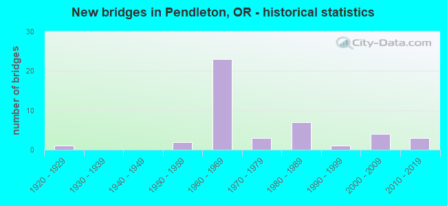
- New bridges - historical statistics
- 11920-1929
- 21950-1959
- 231960-1969
- 31970-1979
- 71980-1989
- 11990-1999
- 42000-2009
- 32010-2019


- Bridge Condition - Deck
- 16.7%Very good
- 36.7%Good
- 33.3%Satisfactory
- 10.0%Fair
- 3.3%Poor

- Bridge Condition - Superstructure
- 22.6%Very good
- 25.8%Good
- 48.4%Satisfactory
- 3.2%Fair

- Bridge Condition - Substructure
- 29.0%Very good
- 48.4%Good
- 12.9%Satisfactory
- 9.7%Fair

- Bridge Condition - Channel
- 10.0%Very good
- 30.0%Good
- 40.0%Satisfactory
- 20.0%Fair
Find on map >> Show street view
Structure Number: 4697A008 00018, Location: 35.1 S. WASH. STATE LINE (Lat: 45.674442, Lng: -118.759394), Route carried "on" structure: State highway 11, Year Built: 1986, Status: Open, Structure Length: 7.43m (24.38ft), Average Daily Traffic: 4,280 (year 2020), Truck Traffic: 16%, Average Future Daily Traffic: 5,300 (year 2040), Design Load: HS 25 or greater, Features Intersected: UMATILLA R (RIVERSIDE)
Minimum Vertical Clearance: 30+ m (98+ ft), Kilometerpoint: 0.290, Lanes on structure: 3, Base Highway Network: Yes, Owner: State Highway Agency, Approaching Roadway Width: 20.7m (67.9ft), Material/Design: Prestressed concrete, Design/Construction: Stringer/Multi-beam, Number Of Spans In Main Unit: 2, Length of Maximum Span: 36.9m (121.1ft), Curb or Sidewalk Widths: Left: 2.4m (7.9ft), Right: 2.4m (7.9ft), Curb-To-Curb Width: 20.7m (67.9ft), Out-to-Out Width: 26.6m (87.3ft)
Condition: Deck: Good, Superstructure: Good, Substructure: Good, Channel: Good, Operating Rating: 27.2 metric tons, Method Used To Determine Operating Rating: Load and Resistance Factor Rating (LRFR) rating reported by rating factor(RF) method using HL-93 loadings, Inventory Rating: 20.7 metric tons, Method Used To Determine Inventory Rating: Load and Resistance Factor Rating (LRFR) rating reported by rating factor(RF) method using HL-93 loadings, Structural Evaluation: Somewhat better than minimum adequacy, Deck Geometry: Superior to present desirable criteria, Waterway Adequacy: Equal to present desirable criteria, Approach Roadway Alignment: Equal to present desirable criteria, Designated Inspection Frequency: Every 24 months, Inspection Date: July 2021, Deck Structure Type: Concrete Cast-file-Place, Wearing Surface/Protective System: Wearing Surface: Monolithic Concrete, Deck Protection: Epoxy Coated Reinforcing
Find on map >> Show street view
Structure Number: 9520 006 2079, Location: 004 MI E JCT US 30 (Lat: 45.673428, Lng: -118.837447), Route carried "on" structure: Interstate 84, Year Built: 1969, Status: Open, Structure Length: 13.44m (44.09ft), Average Daily Traffic: 8,282 (year 2020), Truck Traffic: 33%, Average Future Daily Traffic: 9,100 (year 2040), Design Load: HS 20, Features Intersected: UPRR & REITH HWY
Minimum Vertical Clearance: 30+ m (98+ ft), Kilometerpoint: 334.550, Lanes on structure: 2, Lanes under structure: 2, Base Highway Network: Yes, Owner: State Highway Agency, Approaching Roadway Width: 12.2m (40.0ft), Skew: 14 degrees, Material/Design: Steel continuous, Design/Construction: Stringer/Multi-beam, Number Of Spans In Main Unit: 4, Length of Maximum Span: 39.6m (129.9ft), Curb-To-Curb Width: 13.0m (42.7ft), Out-to-Out Width: 13.0m (42.7ft)
Condition: Deck: Satisfactory, Superstructure: Good, Substructure: Very good, Operating Rating: 10.7 metric tons, Method Used To Determine Operating Rating: Load and Resistance Factor Rating (LRFR) rating reported by rating factor(RF) method using HL-93 loadings, Inventory Rating: 8.4 metric tons, Method Used To Determine Inventory Rating: Load and Resistance Factor Rating (LRFR) rating reported by rating factor(RF) method using HL-93 loadings, Structural Evaluation: High priority of corrective action, Deck Geometry: Superior to present desirable criteria, Underclear: Meets minimum limits, Approach Roadway Alignment: Equal to present desirable criteria, Length Of Structure Improvement: 13.60m (44.62ft), Designated Inspection Frequency: Every 24 months, Inspection Date: April 2020, Bridge Improvement Cost: $1,431,000, Roadway Improvement Cost: $143,000, Total Project Cost: $2,290,000, Deck Structure Type: Concrete Cast-file-Place, Wearing Surface/Protective System: Wearing Surface: Monolithic Concrete
Find on map >> Show street view
Structure Number: 9520A006 20788, Location: 004 MI E JCT US 30 (Lat: 45.673211, Lng: -118.837944), Route carried "on" structure: Interstate 84, Year Built: 1969, Status: Open, Structure Length: 13.44m (44.09ft), Average Daily Traffic: 8,282 (year 2020), Truck Traffic: 33%, Average Future Daily Traffic: 9,100 (year 2040), Design Load: HS 20, Features Intersected: UPRR & RIETH HWY
Minimum Vertical Clearance: 30+ m (98+ ft), Kilometerpoint: 334.550, Lanes on structure: 2, Lanes under structure: 2, Base Highway Network: Yes, Owner: State Highway Agency, Approaching Roadway Width: 12.2m (40.0ft), Skew: 14 degrees, Material/Design: Steel continuous, Design/Construction: Stringer/Multi-beam, Number Of Spans In Main Unit: 4, Length of Maximum Span: 39.6m (129.9ft), Curb-To-Curb Width: 12.3m (40.4ft), Out-to-Out Width: 13.0m (42.7ft)
Condition: Deck: Satisfactory, Superstructure: Good, Substructure: Very good, Operating Rating: 15.2 metric tons, Method Used To Determine Operating Rating: Load and Resistance Factor Rating (LRFR) rating reported by rating factor(RF) method using HL-93 loadings, Inventory Rating: 11.7 metric tons, Method Used To Determine Inventory Rating: Load and Resistance Factor Rating (LRFR) rating reported by rating factor(RF) method using HL-93 loadings, Structural Evaluation: High priority of corrective action, Deck Geometry: Better than present minimum criteria, Underclear: Somewhat better than minimum adequacy, Approach Roadway Alignment: Equal to present desirable criteria, Length Of Structure Improvement: 13.60m (44.62ft), Designated Inspection Frequency: Every 24 months, Inspection Date: April 2020, Bridge Improvement Cost: $1,431,000, Roadway Improvement Cost: $143,000, Total Project Cost: $2,290,000, Deck Structure Type: Concrete Cast-file-Place, Wearing Surface/Protective System: Wearing Surface: Monolithic Concrete
Find on map >> Show street view
Structure Number: 9521 006 20896, Location: 018 MI E JCT US 30 (Lat: 45.666533, Lng: -118.816528), Route carried "on" structure: Interstate 84, Year Built: 1969, Status: Open, Structure Length: 16.06m (52.69ft), Average Daily Traffic: 7,613 (year 2020), Truck Traffic: 33%, Average Future Daily Traffic: 8,850 (year 2040), Design Load: HS 20, Features Intersected: UMATILLA R(PENDLETON) WB
Minimum Vertical Clearance: 30+ m (98+ ft), Kilometerpoint: 336.289, Lanes on structure: 2, Base Highway Network: Yes, Owner: State Highway Agency, Approaching Roadway Width: 12.2m (40.0ft), Skew: 12 degrees, Material/Design: Prestressed concrete continuous, Design/Construction: Stringer/Multi-beam, Number Of Spans In Main Unit: 5, Length of Maximum Span: 33.5m (109.9ft), Curb-To-Curb Width: 12.3m (40.4ft), Out-to-Out Width: 13.0m (42.7ft)
Condition: Deck: Fair, Superstructure: Satisfactory, Substructure: Good, Channel: Satisfactory, Operating Rating: 19.8 metric tons, Method Used To Determine Operating Rating: Load and Resistance Factor Rating (LRFR) rating reported by rating factor(RF) method using HL-93 loadings, Inventory Rating: 15.2 metric tons, Method Used To Determine Inventory Rating: Load and Resistance Factor Rating (LRFR) rating reported by rating factor(RF) method using HL-93 loadings, Structural Evaluation: High priority of corrective action, Deck Geometry: Better than present minimum criteria, Waterway Adequacy: Equal to present desirable criteria, Approach Roadway Alignment: Equal to present desirable criteria, Length Of Structure Improvement: 16.10m (52.82ft), Designated Inspection Frequency: Every 24 months, Inspection Date: April 2020, Bridge Improvement Cost: $1,691,000, Roadway Improvement Cost: $169,000, Total Project Cost: $2,705,000, Deck Structure Type: Concrete Cast-file-Place, Wearing Surface/Protective System: Wearing Surface: Monolithic Concrete
Find on map >> Show street view
Structure Number: 9521A006 20894, Location: 018 MI W JCT ORE 11 (Lat: 45.666425, Lng: -118.817289), Route carried "on" structure: Interstate 84, Year Built: 1969, Status: Open, Structure Length: 20.21m (66.31ft), Average Daily Traffic: 7,613 (year 2020), Truck Traffic: 33%, Average Future Daily Traffic: 8,850 (year 2040), Design Load: HS 20, Features Intersected: UMATILLA R(PENDLETON) EB
Minimum Vertical Clearance: 30+ m (98+ ft), Kilometerpoint: 336.305, Lanes on structure: 2, Base Highway Network: Yes, Owner: State Highway Agency, Approaching Roadway Width: 12.2m (40.0ft), Skew: 13 degrees, Material/Design: Prestressed concrete continuous, Design/Construction: Stringer/Multi-beam, Number Of Spans In Main Unit: 6, Length of Maximum Span: 35.1m (115.2ft), Curb-To-Curb Width: 12.2m (40.0ft), Out-to-Out Width: 13.0m (42.7ft)
Condition: Deck: Fair, Superstructure: Satisfactory, Substructure: Good, Channel: Satisfactory, Operating Rating: 26.6 metric tons, Method Used To Determine Operating Rating: Load and Resistance Factor Rating (LRFR) rating reported by rating factor(RF) method using HL-93 loadings, Inventory Rating: 20.4 metric tons, Method Used To Determine Inventory Rating: Load and Resistance Factor Rating (LRFR) rating reported by rating factor(RF) method using HL-93 loadings, Structural Evaluation: Somewhat better than minimum adequacy, Deck Geometry: Better than present minimum criteria, Waterway Adequacy: Equal to present desirable criteria, Approach Roadway Alignment: Equal to present desirable criteria, Designated Inspection Frequency: Every 24 months, Inspection Date: April 2020, Deck Structure Type: Concrete Cast-file-Place, Wearing Surface/Protective System: Wearing Surface: Monolithic Concrete
Find on map >> Show street view
Structure Number: 9522 006 20954, Location: CITY OF PENDLETON (Lat: 45.663142, Lng: -118.806278), Route carried "on" structure: Interstate 84, Year Built: 1969, Status: Open, Structure Length: 6.68m (21.92ft), Average Daily Traffic: 7,613 (year 2020), Truck Traffic: 33%, Average Future Daily Traffic: 8,850 (year 2040), Design Load: HS 20, Features Intersected: US 395 (HWY 028)
Minimum Vertical Clearance: 30+ m (98+ ft), Kilometerpoint: 337.222, Lanes on structure: 2, Lanes under structure: 5, Base Highway Network: Yes, Owner: State Highway Agency, Approaching Roadway Width: 12.2m (40.0ft), Skew: 10 degrees, Material/Design: Concrete continuous, Design/Construction: Box Beam or Girders - Multiple, Number Of Spans In Main Unit: 3, Length of Maximum Span: 36.6m (120.1ft), Curb-To-Curb Width: 12.2m (40.0ft), Out-to-Out Width: 13.0m (42.7ft)
Condition: Deck: Satisfactory, Superstructure: Satisfactory, Substructure: Good, Operating Rating: 33.4 metric tons, Method Used To Determine Operating Rating: Load and Resistance Factor Rating (LRFR) rating reported by rating factor(RF) method using HL-93 loadings, Inventory Rating: 25.6 metric tons, Method Used To Determine Inventory Rating: Load and Resistance Factor Rating (LRFR) rating reported by rating factor(RF) method using HL-93 loadings, Structural Evaluation: Equal to present minimum criteria, Deck Geometry: Better than present minimum criteria, Underclear: Somewhat better than minimum adequacy, Approach Roadway Alignment: Equal to present desirable criteria, Designated Inspection Frequency: Every 24 months, Inspection Date: Febuary 2021, Deck Structure Type: Concrete Cast-file-Place, Wearing Surface/Protective System: Wearing Surface: Monolithic Concrete
Find on map >> Show street view
Structure Number: 9522A006 20954, Location: CITY OF PENDLETON (Lat: 45.662897, Lng: -118.806458), Route carried "on" structure: Interstate 84, Year Built: 1969, Status: Open, Structure Length: 6.16m (20.21ft), Average Daily Traffic: 7,613 (year 2020), Truck Traffic: 33%, Average Future Daily Traffic: 8,850 (year 2040), Design Load: HS 20, Features Intersected: US 395 (HWY 028)
Minimum Vertical Clearance: 30+ m (98+ ft), Kilometerpoint: 337.222, Lanes on structure: 2, Lanes under structure: 5, Base Highway Network: Yes, Owner: State Highway Agency, Approaching Roadway Width: 12.2m (40.0ft), Skew: 10 degrees, Material/Design: Concrete continuous, Design/Construction: Box Beam or Girders - Multiple, Number Of Spans In Main Unit: 3, Length of Maximum Span: 36.6m (120.1ft), Curb-To-Curb Width: 12.2m (40.0ft), Out-to-Out Width: 13.0m (42.7ft)
Condition: Deck: Satisfactory, Superstructure: Satisfactory, Substructure: Very good, Operating Rating: 33.0 metric tons, Method Used To Determine Operating Rating: Load and Resistance Factor Rating (LRFR) rating reported by rating factor(RF) method using HL-93 loadings, Inventory Rating: 25.6 metric tons, Method Used To Determine Inventory Rating: Load and Resistance Factor Rating (LRFR) rating reported by rating factor(RF) method using HL-93 loadings, Structural Evaluation: Equal to present minimum criteria, Deck Geometry: Better than present minimum criteria, Underclear: Somewhat better than minimum adequacy, Approach Roadway Alignment: Equal to present desirable criteria, Designated Inspection Frequency: Every 24 months, Inspection Date: Febuary 2021, Deck Structure Type: Concrete Cast-file-Place, Wearing Surface/Protective System: Wearing Surface: Monolithic Concrete
Find on map >> Show street view
Structure Number: 9522B028 00174, Location: 00.1 MI S JCT I80N (Lat: 45.662033, Lng: -118.806867), Route carried "on" structure: US 395, Year Built: 1969, Status: Open, Structure Length: 1.04m (3.41ft), Average Daily Traffic: 22,517 (year 2020), Truck Traffic: 4%, Average Future Daily Traffic: 26,100 (year 2040), Design Load: HS 20, Features Intersected: TUTUILLA CREEK
Minimum Vertical Clearance: 30+ m (98+ ft), Kilometerpoint: 2.800, Lanes on structure: 5, Base Highway Network: Yes, Owner: State Highway Agency, Approaching Roadway Width: 26.2m (86.0ft), Skew: 10 degrees, Material/Design: Prestressed concrete, Design/Construction: Box Beam or Girders - Multiple, Number Of Spans In Main Unit: 1, Length of Maximum Span: 9.8m (32.2ft), Curb-To-Curb Width: 26.3m (86.3ft), Out-to-Out Width: 58.5m (191.9ft)
Condition: Superstructure: Satisfactory, Substructure: Satisfactory, Channel: Fair, Operating Rating: 89.7 metric tons, Method Used To Determine Operating Rating: Load and Resistance Factor Rating (LRFR) rating reported by rating factor(RF) method using HL-93 loadings, Inventory Rating: 69.0 metric tons, Method Used To Determine Inventory Rating: Load and Resistance Factor Rating (LRFR) rating reported by rating factor(RF) method using HL-93 loadings, Structural Evaluation: Equal to present minimum criteria, Deck Geometry: Superior to present desirable criteria, Waterway Adequacy: Equal to present desirable criteria, Approach Roadway Alignment: Equal to present desirable criteria, Designated Inspection Frequency: Every 24 months, Inspection Date: August 2020, Deck Structure Type: Concrete Precast Panels
Find on map >> Show street view
Structure Number: 9523 006 21096, Location: 01.4 MI E JCT US 395 (Lat: 45.663539, Lng: -118.778000), Route carried "on" structure: Interstate 84, Year Built: 1969, Status: Open, Structure Length: 5.94m (19.49ft), Average Daily Traffic: 6,868 (year 2020), Truck Traffic: 34%, Average Future Daily Traffic: 7,900 (year 2040), Design Load: HS 20, Features Intersected: OR 11 (HWY 8)
Minimum Vertical Clearance: 30+ m (98+ ft), Kilometerpoint: 339.507, Lanes on structure: 2, Lanes under structure: 3, Base Highway Network: Yes, Owner: State Highway Agency, Approaching Roadway Width: 12.2m (40.0ft), Skew: 10 degrees, Material/Design: Concrete continuous, Design/Construction: Box Beam or Girders - Multiple, Number Of Spans In Main Unit: 3, Length of Maximum Span: 26.8m (87.9ft), Curb-To-Curb Width: 12.2m (40.0ft), Out-to-Out Width: 13.0m (42.7ft)
Condition: Deck: Good, Superstructure: Satisfactory, Substructure: Good, Operating Rating: 28.8 metric tons, Method Used To Determine Operating Rating: Load and Resistance Factor Rating (LRFR) rating reported by rating factor(RF) method using HL-93 loadings, Inventory Rating: 22.4 metric tons, Method Used To Determine Inventory Rating: Load and Resistance Factor Rating (LRFR) rating reported by rating factor(RF) method using HL-93 loadings, Structural Evaluation: Somewhat better than minimum adequacy, Deck Geometry: Better than present minimum criteria, Underclear: Equal to present minimum criteria, Approach Roadway Alignment: Equal to present desirable criteria, Designated Inspection Frequency: Every 24 months, Inspection Date: April 2020, Deck Structure Type: Concrete Cast-file-Place, Wearing Surface/Protective System: Wearing Surface: Epoxy Overlay
Find on map >> Show street view
Structure Number: 9523A006 21096, Location: 01.4 MI E JCT US 395 (Lat: 45.663189, Lng: -118.777864), Route carried "on" structure: Interstate 84, Year Built: 1969, Status: Open, Structure Length: 5.94m (19.49ft), Average Daily Traffic: 6,868 (year 2020), Truck Traffic: 34%, Average Future Daily Traffic: 7,900 (year 2040), Design Load: HS 20, Features Intersected: OR 11 (HWY 8)
Minimum Vertical Clearance: 30+ m (98+ ft), Kilometerpoint: 339.507, Lanes on structure: 2, Lanes under structure: 3, Base Highway Network: Yes, Owner: State Highway Agency, Approaching Roadway Width: 12.2m (40.0ft), Skew: 10 degrees, Material/Design: Concrete continuous, Design/Construction: Box Beam or Girders - Multiple, Number Of Spans In Main Unit: 3, Length of Maximum Span: 26.8m (87.9ft), Curb-To-Curb Width: 12.2m (40.0ft), Out-to-Out Width: 13.0m (42.7ft)
Condition: Deck: Good, Superstructure: Satisfactory, Substructure: Good, Operating Rating: 28.8 metric tons, Method Used To Determine Operating Rating: Load and Resistance Factor Rating (LRFR) rating reported by rating factor(RF) method using HL-93 loadings, Inventory Rating: 22.4 metric tons, Method Used To Determine Inventory Rating: Load and Resistance Factor Rating (LRFR) rating reported by rating factor(RF) method using HL-93 loadings, Structural Evaluation: Somewhat better than minimum adequacy, Deck Geometry: Better than present minimum criteria, Underclear: Equal to present minimum criteria, Approach Roadway Alignment: Equal to present desirable criteria, Designated Inspection Frequency: Every 24 months, Inspection Date: April 2020, Deck Structure Type: Concrete Cast-file-Place, Wearing Surface/Protective System: Wearing Surface: Epoxy Overlay
Find on map >> Show street view
Structure Number: 9524 006 21206, Location: 025 MI E JCT 395 (Lat: 45.663361, Lng: -118.755711), Route carried "on" structure: County highway , Year Built: 1969, Status: Open, Structure Length: 8.11m (26.61ft), Average Daily Traffic: 13,736 (year 2020), Truck Traffic: 34%, Average Future Daily Traffic: 15,800 (year 2040), Design Load: HS 20, Features Intersected: I-84 (HWY 006), Facility Carried by Structure: GOAD RD
Minimum Vertical Clearance: 30+ m (98+ ft), Kilometerpoint: 341.277, Lanes on structure: 2, Lanes under structure: 4, Owner: State Highway Agency, Approaching Roadway Width: 9.8m (32.2ft), Material/Design: Steel continuous, Design/Construction: Stringer/Multi-beam, Number Of Spans In Main Unit: 2, Length of Maximum Span: 40.2m (131.9ft), Curb-To-Curb Width: 9.8m (32.2ft), Out-to-Out Width: 10.6m (34.8ft)
Condition: Deck: Good, Superstructure: Good, Substructure: Good, Operating Rating: 45.4 metric tons, Method Used To Determine Operating Rating: Load and Resistance Factor Rating (LRFR) rating reported by rating factor(RF) method using HL-93 loadings, Inventory Rating: 35.0 metric tons, Method Used To Determine Inventory Rating: Load and Resistance Factor Rating (LRFR) rating reported by rating factor(RF) method using HL-93 loadings, Structural Evaluation: Better than present minimum criteria, Deck Geometry: Meets minimum limits, Underclear: Equal to present minimum criteria, Approach Roadway Alignment: Equal to present desirable criteria, Designated Inspection Frequency: Every 24 months, Critical Feature Inspection Frequency: Every 24 months, Inspection Date: Febuary 2021, Critical Feature Inspection Date: March 2021, Deck Structure Type: Concrete Cast-file-Place, Wearing Surface/Protective System: Wearing Surface: Monolithic Concrete
Find on map >> Show street view
Structure Number: 9535 008X00093, Location: 00.6 MI N JCT FAI-84 (Lat: 45.671331, Lng: -118.779700), Route carried "on" structure: State highway 11, Year Built: 1970, Status: Open, Structure Length: 20.44m (67.06ft), Average Daily Traffic: 5,527 (year 2020), Truck Traffic: 16%, Average Future Daily Traffic: 5,800 (year 2040), Design Load: HS 20, Features Intersected: UPRR & FRAZER AVE
Minimum Vertical Clearance: 30+ m (98+ ft), Kilometerpoint: 1.497, Lanes on structure: 4, Lanes under structure: 4, Base Highway Network: Yes, Owner: State Highway Agency, Approaching Roadway Width: 17.7m (58.1ft), Material/Design: Prestressed concrete continuous, Design/Construction: Box Beam or Girders - Multiple, Number Of Spans In Main Unit: 5, Number Of Approach Spans: 1, Length of Maximum Span: 53.3m (174.9ft), Curb-To-Curb Width: 17.7m (58.1ft), Out-to-Out Width: 18.7m (61.4ft)
Condition: Deck: Fair, Superstructure: Satisfactory, Substructure: Good, Operating Rating: 38.2 metric tons, Method Used To Determine Operating Rating: Load and Resistance Factor Rating (LRFR) rating reported by rating factor(RF) method using HL-93 loadings, Inventory Rating: 29.5 metric tons, Method Used To Determine Inventory Rating: Load and Resistance Factor Rating (LRFR) rating reported by rating factor(RF) method using HL-93 loadings, Structural Evaluation: Equal to present minimum criteria, Deck Geometry: Somewhat better than minimum adequacy, Underclear: Somewhat better than minimum adequacy, Approach Roadway Alignment: Equal to present desirable criteria, Designated Inspection Frequency: Every 24 months, Inspection Date: July 2021, Deck Structure Type: Concrete Cast-file-Place, Wearing Surface/Protective System: Wearing Surface: Monolithic Concrete
Find on map >> Show street view
Structure Number: 9584 006C20287, Location: 081 MI W JCT ORE 11 (Lat: 45.692283, Lng: -118.933411), Route carried "on" structure: Ramp Interstate 84, Year Built: 1968, Status: Open, Structure Length: 10.00m (32.81ft), Average Daily Traffic: 202 (year 2020), Truck Traffic: 32%, Average Future Daily Traffic: 160 (year 2030), Design Load: HS 20, Features Intersected: I-84 (HWY 006), Facility Carried by Structure: BARNHART RD
Minimum Vertical Clearance: 30+ m (98+ ft), Kilometerpoint: 326.488, Lanes on structure: 2, Lanes under structure: 4, Owner: State Highway Agency, Approaching Roadway Width: 10.4m (34.1ft), Material/Design: Steel continuous, Design/Construction: Stringer/Multi-beam, Number Of Spans In Main Unit: 2, Number Of Approach Spans: 2, Length of Maximum Span: 44.5m (146.0ft), Curb-To-Curb Width: 9.8m (32.2ft), Out-to-Out Width: 10.5m (34.4ft)
Condition: Deck: Satisfactory, Superstructure: Good, Substructure: Good, Operating Rating: 29.5 metric tons, Method Used To Determine Operating Rating: Load and Resistance Factor Rating (LRFR) rating reported by rating factor(RF) method using HL-93 loadings, Inventory Rating: 22.7 metric tons, Method Used To Determine Inventory Rating: Load and Resistance Factor Rating (LRFR) rating reported by rating factor(RF) method using HL-93 loadings, Structural Evaluation: Equal to present minimum criteria, Deck Geometry: Equal to present minimum criteria, Underclear: Equal to present minimum criteria, Approach Roadway Alignment: Equal to present desirable criteria, Designated Inspection Frequency: Every 24 months, Critical Feature Inspection Frequency: Every 24 months, Inspection Date: Febuary 2021, Critical Feature Inspection Date: March 2021, Deck Structure Type: Concrete Cast-file-Place, Wearing Surface/Protective System: Wearing Surface: Monolithic Concrete
Find on map >> Show street view
Structure Number: 9636 067 00041, Location: 1.7 MI. W. JCT. OR 37 (Lat: 45.675669, Lng: -118.845150), Route carried "on" structure: US 30, Year Built: 1969, Status: Open, Structure Length: 11.92m (39.11ft), Average Daily Traffic: 4,331 (year 2020), Truck Traffic: 5%, Average Future Daily Traffic: 12,700 (year 2040), Design Load: HS 20, Features Intersected: I-84 (HWY 6)
Minimum Vertical Clearance: 30+ m (98+ ft), Kilometerpoint: 0.660, Lanes on structure: 2, Lanes under structure: 6, Owner: State Highway Agency, Approaching Roadway Width: 12.2m (40.0ft), Skew: 3 degrees, Material/Design: Concrete continuous, Design/Construction: Box Beam or Girders - Multiple, Number Of Spans In Main Unit: 4, Length of Maximum Span: 39.6m (129.9ft), Curb-To-Curb Width: 12.2m (40.0ft), Out-to-Out Width: 12.9m (42.3ft)
Condition: Deck: Satisfactory, Superstructure: Satisfactory, Substructure: Good, Operating Rating: 20.1 metric tons, Method Used To Determine Operating Rating: Load and Resistance Factor Rating (LRFR) rating reported by rating factor(RF) method using HL-93 loadings, Inventory Rating: 15.6 metric tons, Method Used To Determine Inventory Rating: Load and Resistance Factor Rating (LRFR) rating reported by rating factor(RF) method using HL-93 loadings, Structural Evaluation: Meets minimum limits, Deck Geometry: Equal to present minimum criteria, Underclear: Superior to present desirable criteria, Approach Roadway Alignment: Equal to present desirable criteria, Designated Inspection Frequency: Every 24 months, Inspection Date: August 2020, Deck Structure Type: Concrete Cast-file-Place, Wearing Surface/Protective System: Wearing Surface: Monolithic Concrete
Find on map >> Show street view
Structure Number: 9778 885100008, Location: 0.1 MI E TUTUILLA CR. RD. (Lat: 45.661400, Lng: -118.804339), Route carried "on" structure: City street , Year Built: 1967, Status: Open, Structure Length: 2.19m (7.19ft), Average Daily Traffic: 63 (year 2020), Average Future Daily Traffic: 73 (year 2025), Design Load: HS 20, Features Intersected: TUTUILLA CREEK, Facility Carried by Structure: SW HAILEY AVENUE
Minimum Vertical Clearance: 30+ m (98+ ft), Kilometerpoint: 0.129, Lanes on structure: 2, Owner: City or Municipal Highway Agency, Approaching Roadway Width: 10.1m (33.1ft), Material/Design: Concrete continuous, Design/Construction: Slab, Number Of Spans In Main Unit: 3, Length of Maximum Span: 8.5m (27.9ft), Curb or Sidewalk Widths: Left: 0.0m, Right: 1.6m (5.2ft), Curb-To-Curb Width: 9.8m (32.2ft), Out-to-Out Width: 12.6m (41.3ft)
Condition: Deck: Satisfactory, Superstructure: Good, Substructure: Good, Channel: Satisfactory, Operating Rating: 64.4 metric tons, Method Used To Determine Operating Rating: Load Factor (LF), Inventory Rating: 39.0 metric tons, Method Used To Determine Inventory Rating: Load Factor (LF), Structural Evaluation: Better than present minimum criteria, Deck Geometry: Equal to present desirable criteria, Waterway Adequacy: Equal to present desirable criteria, Approach Roadway Alignment: Equal to present minimum criteria, Designated Inspection Frequency: Every 24 months, Inspection Date: July 2020, Deck Structure Type: Concrete Cast-file-Place, Wearing Surface/Protective System: Wearing Surface: Monolithic Concrete
Find on map >> Show street view
Structure Number: 10542A353000055, Location: 0.1 MI N OF HWY 30 (Lat: 45.674081, Lng: -118.788528), Route carried "on" structure: City street , Year Built: 1980, Status: Open, Structure Length: 6.16m (20.21ft), Average Daily Traffic: 8,232 (year 2020), Truck Traffic: 10%, Average Future Daily Traffic: 14,454 (year 2025), Design Load: HS 20, Features Intersected: UMATILLA RIVER, Facility Carried by Structure: MAIN STREET
Minimum Vertical Clearance: 30+ m (98+ ft), Kilometerpoint: 0.885, Lanes on structure: 2, Owner: City or Municipal Highway Agency, Approaching Roadway Width: 14.6m (47.9ft), Material/Design: Prestressed concrete, Design/Construction: Box Beam or Girders - Multiple, Number Of Spans In Main Unit: 2, Length of Maximum Span: 29.9m (98.1ft), Curb or Sidewalk Widths: Left: 2.1m (6.9ft), Right: 2.1m (6.9ft), Curb-To-Curb Width: 14.7m (48.2ft), Out-to-Out Width: 19.7m (64.6ft)
Condition: Deck: Good, Superstructure: Satisfactory, Substructure: Satisfactory, Channel: Good, Operating Rating: 66.7 metric tons, Method Used To Determine Operating Rating: Load and Resistance Factor Rating (LRFR) rating reported by rating factor(RF) method using HL-93 loadings, Inventory Rating: 51.5 metric tons, Method Used To Determine Inventory Rating: Load and Resistance Factor Rating (LRFR) rating reported by rating factor(RF) method using HL-93 loadings, Structural Evaluation: Equal to present minimum criteria, Deck Geometry: Superior to present desirable criteria, Waterway Adequacy: Equal to present desirable criteria, Approach Roadway Alignment: Equal to present desirable criteria, Length Of Structure Improvement: 6.20m (20.34ft), Designated Inspection Frequency: Every 24 months, Underwater Inspection Frequency: Every 60 months, Inspection Date: July 2020, Underwater Inspection Date: July 2019, Bridge Improvement Cost: $647,000, Roadway Improvement Cost: $65,000, Total Project Cost: $1,035,000, Wearing Surface/Protective System: Wearing Surface: Bituminous
Find on map >> Show street view
Structure Number: 18661 067 00406, Location: 00.6 MI NW JCT FAI-84 (Lat: 45.673431, Lng: -118.774619), Route carried "on" structure: US 30, Year Built: 2002, Status: Open, Structure Length: 22.49m (73.79ft), Average Daily Traffic: 8,490 (year 2020), Truck Traffic: 15%, Average Future Daily Traffic: 12,600 (year 2040), Design Load: HL 93, Features Intersected: UPRR (EASTGATE)
Minimum Vertical Clearance: 30+ m (98+ ft), Kilometerpoint: 6.534, Lanes on structure: 2, Lanes under structure: 2, Base Highway Network: Yes, Owner: State Highway Agency, Approaching Roadway Width: 14.6m (47.9ft), Skew: 4 degrees, Material/Design: Prestressed concrete continuous, Design/Construction: Stringer/Multi-beam, Number Of Spans In Main Unit: 8, Length of Maximum Span: 28.0m (91.9ft), Curb or Sidewalk Widths: Left: 2.1m (6.9ft), Right: 2.1m (6.9ft), Curb-To-Curb Width: 15.0m (49.2ft), Out-to-Out Width: 20.0m (65.6ft)
Condition: Deck: Good, Superstructure: Very good, Substructure: Very good, Operating Rating: 29.2 metric tons, Method Used To Determine Operating Rating: Load and Resistance Factor Rating (LRFR) rating reported by rating factor(RF) method using HL-93 loadings, Inventory Rating: 22.7 metric tons, Method Used To Determine Inventory Rating: Load and Resistance Factor Rating (LRFR) rating reported by rating factor(RF) method using HL-93 loadings, Structural Evaluation: Somewhat better than minimum adequacy, Deck Geometry: Superior to present desirable criteria, Underclear: Better than present minimum criteria, Approach Roadway Alignment: Equal to present desirable criteria, Designated Inspection Frequency: Every 24 months, Inspection Date: August 2020, Deck Structure Type: Concrete Cast-file-Place, Wearing Surface/Protective System: Wearing Surface: Monolithic Concrete, Deck Protection: Epoxy Coated Reinforcing
Find on map >> Show street view
Structure Number: 18714, Location: .05 MI S TUTUILLA ROAD (Lat: 45.654464, Lng: -118.795044), Route carried "on" structure: City street , Year Built: 1998, Status: Open, Structure Length: 1.34m (4.40ft), Average Daily Traffic: 99 (year 2020), Average Future Daily Traffic: 119 (year 2025), Design Load: HS 20, Features Intersected: TUTUILLA CREEK, Facility Carried by Structure: SW NYE AVE
Minimum Vertical Clearance: 30+ m (98+ ft), Kilometerpoint: 0.000, Lanes on structure: 2, Owner: City or Municipal Highway Agency, Approaching Roadway Width: 13.4m (44.0ft), Material/Design: Concrete continuous, Design/Construction: Culvert, Number Of Spans In Main Unit: 2, Length of Maximum Span: 7.3m (24.0ft), Curb or Sidewalk Widths: Left: 2.7m (8.9ft), Right: 2.7m (8.9ft), Curb-To-Curb Width: 13.4m (44.0ft), Out-to-Out Width: 19.5m (64.0ft)
Condition: Channel: Satisfactory, Culverts: Very good, Operating Rating: 45.0 metric tons, Method Used To Determine Operating Rating: Load and Resistance Factor Rating (LRFR) rating reported by rating factor(RF) method using HL-93 loadings, Inventory Rating: 34.7 metric tons, Method Used To Determine Inventory Rating: Load and Resistance Factor Rating (LRFR) rating reported by rating factor(RF) method using HL-93 loadings, Structural Evaluation: Equal to present desirable criteria, Deck Geometry: Superior to present desirable criteria, Waterway Adequacy: Better than present minimum criteria, Approach Roadway Alignment: Equal to present desirable criteria, Designated Inspection Frequency: Every 24 months, Inspection Date: July 2020, Deck Structure Type: Concrete Cast-file-Place, Wearing Surface/Protective System: Wearing Surface: Bituminous
Find on map >> Show street view
Structure Number: 19092 067 00216, Location: 2.2 MI. E. JCT. I-84 (Lat: 45.671319, Lng: -118.810569), Route carried "on" structure: US 30, Year Built: 2005, Status: Open, Structure Length: 14.48m (47.51ft), Average Daily Traffic: 9,525 (year 2020), Truck Traffic: 5%, Average Future Daily Traffic: 14,300 (year 2040), Design Load: HL 93, Features Intersected: UMATILLA RIVER
Minimum Vertical Clearance: 30+ m (98+ ft), Kilometerpoint: 3.476, Lanes on structure: 4, Base Highway Network: Yes, Owner: State Highway Agency, Approaching Roadway Width: 19.2m (63.0ft), Skew: 3 degrees, Material/Design: Prestressed concrete, Design/Construction: Stringer/Multi-beam, Number Of Spans In Main Unit: 3, Length of Maximum Span: 48.0m (157.5ft), Curb or Sidewalk Widths: Left: 2.1m (6.9ft), Right: 2.1m (6.9ft), Curb-To-Curb Width: 19.2m (63.0ft), Out-to-Out Width: 24.1m (79.1ft)
Condition: Deck: Good, Superstructure: Very good, Substructure: Very good, Channel: Good, Operating Rating: 64.8 metric tons, Method Used To Determine Operating Rating: Load and Resistance Factor Rating (LRFR) rating reported by rating factor(RF) method using HL-93 loadings, Inventory Rating: 49.9 metric tons, Method Used To Determine Inventory Rating: Load and Resistance Factor Rating (LRFR) rating reported by rating factor(RF) method using HL-93 loadings, Structural Evaluation: Equal to present desirable criteria, Deck Geometry: Equal to present minimum criteria, Waterway Adequacy: Equal to present desirable criteria, Approach Roadway Alignment: Equal to present desirable criteria, Designated Inspection Frequency: Every 24 months, Inspection Date: August 2020, Deck Structure Type: Concrete Cast-file-Place, Wearing Surface/Protective System: Wearing Surface: Monolithic Concrete, Deck Protection: Epoxy Coated Reinforcing
Find on map >> Show street view
Structure Number: 19093 067 00217, Location: 2.2 MI E OF I-84 JCT. (Lat: 45.670469, Lng: -118.809819), Route carried "on" structure: City street 30, Year Built: 2005, Status: Open, Structure Length: 3.32m (10.89ft), Average Daily Traffic: 9,525 (year 2020), Truck Traffic: 5%, Average Future Daily Traffic: 14,300 (year 2040), Design Load: HL 93, Features Intersected: UPRR, Facility Carried by Structure: HWY 67 CONN
Minimum Vertical Clearance: 30+ m (98+ ft), Kilometerpoint: 3.492, Lanes on structure: 3, Owner: State Highway Agency, Approaching Roadway Width: 14.9m (48.9ft), Material/Design: Prestressed concrete, Design/Construction: Box Beam or Girders - Multiple, Number Of Spans In Main Unit: 1, Length of Maximum Span: 32.6m (107.0ft), Curb or Sidewalk Widths: Left: 2.1m (6.9ft), Right: 2.1m (6.9ft), Curb-To-Curb Width: 15.0m (49.2ft), Out-to-Out Width: 19.9m (65.3ft)
Condition: Deck: Very good, Superstructure: Very good, Substructure: Very good, Operating Rating: 89.7 metric tons, Method Used To Determine Operating Rating: Load and Resistance Factor Rating (LRFR) rating reported by rating factor(RF) method using HL-93 loadings, Inventory Rating: 69.0 metric tons, Method Used To Determine Inventory Rating: Load and Resistance Factor Rating (LRFR) rating reported by rating factor(RF) method using HL-93 loadings, Structural Evaluation: Equal to present desirable criteria, Deck Geometry: Equal to present minimum criteria, Underclear: Superior to present desirable criteria, Approach Roadway Alignment: Equal to present desirable criteria, Designated Inspection Frequency: Every 24 months, Inspection Date: August 2020, Deck Structure Type: Concrete Cast-file-Place, Wearing Surface/Protective System: Wearing Surface: Monolithic Concrete, Deck Protection: Epoxy Coated Reinforcing
Find on map >> Show street view
Structure Number: 20869 028 00577, Location: 04.1 MI S JCT I-84 (Lat: 45.609486, Lng: -118.801933), Route carried "on" structure: US 395, Year Built: 2010, Status: Open, Structure Length: 3.66m (12.01ft), Average Daily Traffic: 3,949 (year 2020), Truck Traffic: 20%, Average Future Daily Traffic: 5,000 (year 2040), Design Load: HL 93, Features Intersected: MCKAY CREEK
Minimum Vertical Clearance: 30+ m (98+ ft), Kilometerpoint: 9.286, Lanes on structure: 3, Base Highway Network: Yes, Owner: State Highway Agency, Approaching Roadway Width: 15.8m (51.8ft), Skew: 1 degrees, Material/Design: Prestressed concrete, Design/Construction: Stringer/Multi-beam, Number Of Spans In Main Unit: 1, Length of Maximum Span: 36.6m (120.1ft), Curb-To-Curb Width: 17.1m (56.1ft), Out-to-Out Width: 18.0m (59.1ft)
Condition: Deck: Very good, Superstructure: Very good, Substructure: Very good, Channel: Very good, Operating Rating: 65.4 metric tons, Method Used To Determine Operating Rating: Load and Resistance Factor Rating (LRFR) rating reported by rating factor(RF) method using HL-93 loadings, Inventory Rating: 50.5 metric tons, Method Used To Determine Inventory Rating: Load and Resistance Factor Rating (LRFR) rating reported by rating factor(RF) method using HL-93 loadings, Structural Evaluation: Equal to present desirable criteria, Deck Geometry: Superior to present desirable criteria, Waterway Adequacy: Equal to present desirable criteria, Approach Roadway Alignment: Equal to present desirable criteria, Designated Inspection Frequency: Every 24 months, Inspection Date: August 2020, Deck Structure Type: Concrete Cast-file-Place, Wearing Surface/Protective System: Wearing Surface: Monolithic Concrete, Deck Protection: Epoxy Coated Reinforcing
Find on map >> Show street view
Structure Number: 211920130700008, Location: 0.1 MI W OF CO RD 1303 (Lat: 45.645522, Lng: -118.822778), Route carried "on" structure: County highway , Year Built: 2010, Status: Open, Structure Length: 2.87m (9.42ft), Average Daily Traffic: 4,501 (year 2020), Truck Traffic: 25%, Average Future Daily Traffic: 4,876 (year 2025), Design Load: HL 93, Features Intersected: MCKAY CREEK, Facility Carried by Structure: SW QUINNEY AVENUE
Minimum Vertical Clearance: 30+ m (98+ ft), Kilometerpoint: 0.129, Lanes on structure: 2, Owner: City or Municipal Highway Agency, Approaching Roadway Width: 10.7m (35.1ft), Skew: 4 degrees, Material/Design: Prestressed concrete, Design/Construction: Box Beam or Girders - Multiple, Number Of Spans In Main Unit: 1, Length of Maximum Span: 26.8m (87.9ft), Curb or Sidewalk Widths: Left: 2.0m (6.6ft), Right: 2.0m (6.6ft), Curb-To-Curb Width: 10.7m (35.1ft), Out-to-Out Width: 15.2m (49.9ft)
Condition: Deck: Very good, Superstructure: Very good, Substructure: Very good, Channel: Very good, Operating Rating: 39.5 metric tons, Method Used To Determine Operating Rating: Load and Resistance Factor Rating (LRFR) rating reported by rating factor(RF) method using HL-93 loadings, Inventory Rating: 30.5 metric tons, Method Used To Determine Inventory Rating: Load and Resistance Factor Rating (LRFR) rating reported by rating factor(RF) method using HL-93 loadings, Structural Evaluation: Better than present minimum criteria, Deck Geometry: Somewhat better than minimum adequacy, Waterway Adequacy: Equal to present desirable criteria, Approach Roadway Alignment: Equal to present desirable criteria, Designated Inspection Frequency: Every 24 months, Inspection Date: July 2020, Deck Structure Type: Concrete Cast-file-Place, Wearing Surface/Protective System: Wearing Surface: Bituminous, Membrane: Preformed Fabric, Deck Protection: Epoxy Coated Reinforcing
Find on map >> Show street view
Structure Number: 22577 983 00001, Location: 0.1 MI N OF COURT AVENUE (Lat: 45.676353, Lng: -118.779689), Route carried "on" structure: County highway , Year Built: 2019, Status: Open, Structure Length: 8.23m (27.00ft), Average Daily Traffic: 551 (year 2010), Truck Traffic: 10%, Average Future Daily Traffic: 675 (year 2030), Design Load: HL 93, Features Intersected: UMATILLA RIVER, Facility Carried by Structure: 8th Street
Minimum Vertical Clearance: 30+ m (98+ ft), Kilometerpoint: 0.016, Lanes on structure: 2, Owner: City or Municipal Highway Agency, Approaching Roadway Width: 7.9m (25.9ft), Material/Design: Steel, Design/Construction: Truss - Thru, Number Of Spans In Main Unit: 1, Number Of Approach Spans: 2, Length of Maximum Span: 58.5m (191.9ft), Curb or Sidewalk Widths: Left: 0.0m, Right: 2.4m (7.9ft), Curb-To-Curb Width: 10.4m (34.1ft), Out-to-Out Width: 13.6m (44.6ft)
Condition: Deck: Good, Superstructure: Very good, Substructure: Very good, Channel: Good, Operating Rating: 36.3 metric tons, Method Used To Determine Operating Rating: Load and Resistance Factor Rating (LRFR) rating reported by rating factor(RF) method using HL-93 loadings, Inventory Rating: 28.2 metric tons, Method Used To Determine Inventory Rating: Load and Resistance Factor Rating (LRFR) rating reported by rating factor(RF) method using HL-93 loadings, Structural Evaluation: Better than present minimum criteria, Deck Geometry: Equal to present minimum criteria, Waterway Adequacy: Equal to present desirable criteria, Approach Roadway Alignment: Equal to present desirable criteria, Designated Inspection Frequency: Every 24 months, Critical Feature Inspection Frequency: Every 24 months, Inspection Date: May 2021, Critical Feature Inspection Date: May 2021, Deck Structure Type: Concrete Cast-file-Place, Wearing Surface/Protective System: Wearing Surface: Monolithic Concrete, Deck Protection: Epoxy Coated Reinforcing
Find on map >> Show street view
Structure Number: 24T03, Location: 0.1 MI N OF COURT AVENUE (Lat: 45.670675, Lng: -118.797286), Route carried "on" structure: City street , Year Built: 1987, Status: Open, Structure Length: 6.71m (22.01ft), Average Daily Traffic: 8,728 (year 2020), Truck Traffic: 2%, Average Future Daily Traffic: 15,519 (year 2025), Features Intersected: UMATILLA RIVER, Facility Carried by Structure: SW 10TH STREET
Minimum Vertical Clearance: 30+ m (98+ ft), Kilometerpoint: 0.322, Lanes on structure: 2, Owner: City or Municipal Highway Agency, Approaching Roadway Width: 11.0m (36.1ft), Material/Design: Concrete continuous, Design/Construction: Box Beam or Girders - Single/Spread, Number Of Spans In Main Unit: 3, Length of Maximum Span: 24.4m (80.1ft), Curb or Sidewalk Widths: Left: 1.8m (5.9ft), Right: 1.8m (5.9ft), Curb-To-Curb Width: 11.0m (36.1ft), Out-to-Out Width: 15.5m (50.9ft)
Condition: Deck: Satisfactory, Superstructure: Fair, Substructure: Fair, Channel: Fair, Operating Rating: 40.8 metric tons, Method Used To Determine Operating Rating: Load and Resistance Factor Rating (LRFR) rating reported by rating factor(RF) method using HL-93 loadings, Inventory Rating: 31.4 metric tons, Method Used To Determine Inventory Rating: Load and Resistance Factor Rating (LRFR) rating reported by rating factor(RF) method using HL-93 loadings, Structural Evaluation: Somewhat better than minimum adequacy, Deck Geometry: Meets minimum limits, Waterway Adequacy: Equal to present desirable criteria, Approach Roadway Alignment: Equal to present desirable criteria, Designated Inspection Frequency: Every 24 months, Underwater Inspection Frequency: Every 60 months, Inspection Date: July 2021, Underwater Inspection Date: July 2019, Deck Structure Type: Concrete Cast-file-Place, Wearing Surface/Protective System: Wearing Surface: Monolithic Concrete
Find on map >> Show street view
Structure Number: 59C002130700241, Location: 0.05 MI N OF BIRCH CR.RD. (Lat: 45.622100, Lng: -118.839353), Route carried "on" structure: County highway , Year Built: 1968, Status: Open, Structure Length: 1.86m (6.10ft), Average Daily Traffic: 135 (year 2020), Truck Traffic: 25%, Average Future Daily Traffic: 150 (year 2025), Design Load: HS 20, Features Intersected: BIRCH CREEK, Facility Carried by Structure: KORVOLA ROAD
Minimum Vertical Clearance: 30+ m (98+ ft), Kilometerpoint: 3.879, Lanes on structure: 2, Owner: County Highway Agency, Approaching Roadway Width: 5.5m (18.0ft), Material/Design: Steel, Design/Construction: Stringer/Multi-beam, Number Of Spans In Main Unit: 1, Length of Maximum Span: 18.0m (59.1ft), Curb-To-Curb Width: 7.3m (24.0ft), Out-to-Out Width: 7.3m (24.0ft)
Condition: Deck: Good, Superstructure: Satisfactory, Substructure: Good, Channel: Good, Operating Rating: 53.5 metric tons, Method Used To Determine Operating Rating: Load Factor (LF), Inventory Rating: 32.7 metric tons, Method Used To Determine Inventory Rating: Load Factor (LF), Structural Evaluation: Equal to present minimum criteria, Deck Geometry: Somewhat better than minimum adequacy, Waterway Adequacy: Equal to present desirable criteria, Approach Roadway Alignment: Equal to present desirable criteria, Designated Inspection Frequency: Every 24 months, Inspection Date: July 2020, Deck Structure Type: Corrugated Steel, Wearing Surface/Protective System: Wearing Surface: Bituminous
Find on map >> Show street view
Structure Number: 59C00513500197, Location: 0.8 MI W OF HWY 395 (Lat: 45.596700, Lng: -118.813639), Route carried "on" structure: County highway , Year Built: 1980, Status: Open, Structure Length: 2.32m (7.61ft), Average Daily Traffic: 169 (year 2020), Truck Traffic: 20%, Average Future Daily Traffic: 196 (year 2025), Design Load: HS 20, Features Intersected: BIRCH CREEK, Facility Carried by Structure: COOMBS CANYON RD
Minimum Vertical Clearance: 30+ m (98+ ft), Kilometerpoint: 31.704, Lanes on structure: 2, Owner: County Highway Agency, Approaching Roadway Width: 7.0m (23.0ft), Material/Design: Prestressed concrete, Design/Construction: Box Beam or Girders - Multiple, Number Of Spans In Main Unit: 1, Length of Maximum Span: 22.9m (75.1ft), Curb-To-Curb Width: 8.4m (27.6ft), Out-to-Out Width: 8.5m (27.9ft)
Condition: Deck: Very good, Superstructure: Very good, Substructure: Good, Channel: Satisfactory, Operating Rating: 56.2 metric tons, Method Used To Determine Operating Rating: Allowable Stress (AS), Inventory Rating: 33.6 metric tons, Method Used To Determine Inventory Rating: Allowable Stress (AS), Structural Evaluation: Better than present minimum criteria, Deck Geometry: Somewhat better than minimum adequacy, Waterway Adequacy: Equal to present desirable criteria, Approach Roadway Alignment: Equal to present desirable criteria, Designated Inspection Frequency: Every 24 months, Inspection Date: July 2020, Deck Structure Type: Concrete Cast-file-Place, Wearing Surface/Protective System: Wearing Surface: Bituminous
Find on map >> Show street view
Structure Number: 59C006130800011, Location: 0.1 MI W OF SW 37TH ST (Lat: 45.654261, Lng: -118.824050), Route carried "on" structure: County highway , Year Built: 1988, Status: Open, Structure Length: 1.25m (4.10ft), Average Daily Traffic: 450 (year 2020), Truck Traffic: 5%, Average Future Daily Traffic: 485 (year 2025), Design Load: HS 20, Features Intersected: MCKAY CREEK, Facility Carried by Structure: SW KIRK STREET
Minimum Vertical Clearance: 30+ m (98+ ft), Kilometerpoint: 0.177, Lanes on structure: 1, Owner: City or Municipal Highway Agency, Approaching Roadway Width: 6.4m (21.0ft), Material/Design: Steel, Design/Construction: Stringer/Multi-beam, Number Of Spans In Main Unit: 1, Length of Maximum Span: 11.9m (39.0ft), Curb or Sidewalk Widths: Left: 0.0m, Right: 0.9m (3.0ft), Curb-To-Curb Width: 3.4m (11.2ft), Out-to-Out Width: 4.7m (15.4ft)
Condition: Deck: Satisfactory, Superstructure: Satisfactory, Substructure: Good, Channel: Good, Operating Rating: 57.2 metric tons, Method Used To Determine Operating Rating: Load Factor (LF), Inventory Rating: 34.5 metric tons, Method Used To Determine Inventory Rating: Load Factor (LF), Structural Evaluation: Equal to present minimum criteria, Deck Geometry: High priority of replacement, Waterway Adequacy: Equal to present minimum criteria, Approach Roadway Alignment: High priority of corrective action, Length Of Structure Improvement: 1.20m (3.94ft), Designated Inspection Frequency: Every 24 months, Underwater Inspection Frequency: Every 60 months, Inspection Date: July 2020, Underwater Inspection Date: March 2020, Bridge Improvement Cost: $131,000, Roadway Improvement Cost: $13,000, Total Project Cost: $210,000, Deck Structure Type: Concrete Cast-file-Place, Wearing Surface/Protective System: Wearing Surface: Monolithic Concrete
Find on map >> Show street view
Structure Number: 59C052345500032, Location: 0.3 MI E OF HWY 395 (Lat: 45.659442, Lng: -118.798925), Route carried "on" structure: City street , Year Built: 1988, Status: Open, Structure Length: 1.10m (3.61ft), Average Daily Traffic: 4,062 (year 2020), Truck Traffic: 5%, Average Future Daily Traffic: 4,714 (year 2025), Design Load: HS 20, Features Intersected: TUTUILLA CREEK, Facility Carried by Structure: TUTUILLA CR. ROAD
Minimum Vertical Clearance: 30+ m (98+ ft), Kilometerpoint: 0.515, Lanes on structure: 2, Owner: City or Municipal Highway Agency, Approaching Roadway Width: 13.4m (44.0ft), Material/Design: Prestressed concrete, Design/Construction: Slab, Number Of Spans In Main Unit: 1, Length of Maximum Span: 10.7m (35.1ft), Curb or Sidewalk Widths: Left: 1.8m (5.9ft), Right: 1.8m (5.9ft), Curb-To-Curb Width: 13.4m (44.0ft), Out-to-Out Width: 18.1m (59.4ft)
Condition: Deck: Very good, Superstructure: Good, Substructure: Satisfactory, Channel: Satisfactory, Operating Rating: 73.5 metric tons, Method Used To Determine Operating Rating: Allowable Stress (AS), Inventory Rating: 44.5 metric tons, Method Used To Determine Inventory Rating: Allowable Stress (AS), Structural Evaluation: Equal to present minimum criteria, Deck Geometry: Better than present minimum criteria, Waterway Adequacy: Equal to present desirable criteria, Approach Roadway Alignment: Equal to present desirable criteria, Designated Inspection Frequency: Every 24 months, Inspection Date: July 2020, Wearing Surface/Protective System: Wearing Surface: Bituminous
Find on map >> Show street view
Structure Number: 59C053345500089, Location: 0.9 MI E OF HWY 395 (Lat: 45.654144, Lng: -118.793747), Route carried "on" structure: City street , Year Built: 1988, Status: Open, Structure Length: 0.98m (3.22ft), Average Daily Traffic: 4,480 (year 2020), Truck Traffic: 5%, Average Future Daily Traffic: 6,398 (year 2025), Design Load: HS 20, Features Intersected: PATAWA CREEK, Facility Carried by Structure: TUTUILLA CR. ROAD
Minimum Vertical Clearance: 30+ m (98+ ft), Kilometerpoint: 1.432, Lanes on structure: 2, Owner: City or Municipal Highway Agency, Approaching Roadway Width: 13.4m (44.0ft), Skew: 2 degrees, Material/Design: Prestressed concrete, Design/Construction: Slab, Number Of Spans In Main Unit: 1, Length of Maximum Span: 9.4m (30.8ft), Curb or Sidewalk Widths: Left: 1.8m (5.9ft), Right: 1.8m (5.9ft), Curb-To-Curb Width: 13.4m (44.0ft), Out-to-Out Width: 18.0m (59.1ft)
Condition: Deck: Good, Superstructure: Good, Substructure: Good, Channel: Satisfactory, Operating Rating: 84.4 metric tons, Method Used To Determine Operating Rating: Allowable Stress (AS), Inventory Rating: 50.8 metric tons, Method Used To Determine Inventory Rating: Allowable Stress (AS), Structural Evaluation: Better than present minimum criteria, Deck Geometry: Better than present minimum criteria, Waterway Adequacy: Equal to present desirable criteria, Approach Roadway Alignment: Equal to present desirable criteria, Designated Inspection Frequency: Every 24 months, Inspection Date: July 2020, Deck Structure Type: Other, Wearing Surface/Protective System: Wearing Surface: Bituminous
Find on map >> Show street view
Structure Number: 59C054131100041, Location: 0.4 MI SW OF HWY 395 (Lat: 45.617294, Lng: -118.808064), Route carried "on" structure: County highway , Year Built: 1923, Status: Open, Structure Length: 6.22m (20.41ft), Average Daily Traffic: 298 (year 2020), Truck Traffic: 5%, Average Future Daily Traffic: 308 (year 2025), Design Load: HS 20, Features Intersected: MCKAY CREEK, Facility Carried by Structure: SCHROEDER ROAD
Minimum Vertical Clearance: 30+ m (98+ ft), Kilometerpoint: 0.660, Lanes on structure: 2, Owner: County Highway Agency, Approaching Roadway Width: 6.1m (20.0ft), Skew: 3 degrees, Material/Design: Concrete continuous, Design/Construction: Tee Beam, Number Of Spans In Main Unit: 2, Number Of Approach Spans: 2, Length of Maximum Span: 15.2m (49.9ft), Curb-To-Curb Width: 5.9m (19.4ft), Out-to-Out Width: 6.9m (22.6ft)
Condition: Deck: Good, Superstructure: Satisfactory, Substructure: Fair, Channel: Fair, Operating Rating: 56.2 metric tons, Method Used To Determine Operating Rating: Load Factor (LF), Inventory Rating: 33.6 metric tons, Method Used To Determine Inventory Rating: Load Factor (LF), Structural Evaluation: Somewhat better than minimum adequacy, Deck Geometry: High priority of corrective action, Waterway Adequacy: Equal to present desirable criteria, Approach Roadway Alignment: Equal to present desirable criteria, Length Of Structure Improvement: 6.20m (20.34ft), Designated Inspection Frequency: Every 24 months, Underwater Inspection Frequency: Every 36 months, Inspection Date: July 2020, Underwater Inspection Date: March 2020, Bridge Improvement Cost: $653,000, Roadway Improvement Cost: $65,000, Total Project Cost: $1,045,000, Deck Structure Type: Concrete Cast-file-Place, Wearing Surface/Protective System: Wearing Surface: Bituminous
Find on map >> Show street view
Structure Number: 59C069130100041, Location: 0.4 MI S OF RIETH ROAD (Lat: 45.657506, Lng: -118.876672), Route carried "on" structure: County highway , Year Built: 1953, Status: Posted for load, Structure Length: 7.47m (24.51ft), Average Daily Traffic: 281 (year 2020), Truck Traffic: 25%, Average Future Daily Traffic: 326 (year 2025), Design Load: HS 20, Features Intersected: UMATILLA RIVER, Facility Carried by Structure: BIRCH CREEK ROAD
Minimum Vertical Clearance: 30+ m (98+ ft), Kilometerpoint: 0.660, Lanes on structure: 2, Owner: County Highway Agency, Approaching Roadway Width: 7.9m (25.9ft), Material/Design: Steel, Design/Construction: Girder and Floorbeam System, Number Of Spans In Main Unit: 1, Number Of Approach Spans: 3, Length of Maximum Span: 30.5m (100.1ft), Curb-To-Curb Width: 6.1m (20.0ft), Out-to-Out Width: 6.1m (20.0ft)
Condition: Deck: Poor, Superstructure: Satisfactory, Substructure: Fair, Channel: Satisfactory, Operating Rating: 6.8 metric tons, Method Used To Determine Operating Rating: Load and Resistance Factor Rating (LRFR) rating reported by rating factor(RF) method using HL-93 loadings, Inventory Rating: 5.2 metric tons, Method Used To Determine Inventory Rating: Load and Resistance Factor Rating (LRFR) rating reported by rating factor(RF) method using HL-93 loadings, Structural Evaluation: High priority of replacement, Deck Geometry: Meets minimum limits, Waterway Adequacy: Equal to present desirable criteria, Approach Roadway Alignment: Equal to present minimum criteria, Bridge Posting: Required (Relationship of Operating Rating to Maximum Legal Load: > 39.9% below), Length Of Structure Improvement: 8.20m (26.90ft), Designated Inspection Frequency: Every 12 months, Inspection Date: July 2021, Bridge Improvement Cost: $863,000, Roadway Improvement Cost: $86,000, Total Project Cost: $1,380,000, Deck Structure Type: Corrugated Steel, Wearing Surface/Protective System: Wearing Surface: Bituminous
Find on map >> Show street view
Structure Number: 59C07113010013, Location: 1.3 MI S OF RIETH ROAD (Lat: 45.646694, Lng: -118.872503), Route carried "on" structure: County highway , Year Built: 1959, Status: Open, Structure Length: 1.25m (4.10ft), Average Daily Traffic: 168 (year 2020), Truck Traffic: 25%, Average Future Daily Traffic: 198 (year 2025), Design Load: HS 20, Features Intersected: BIRCH CREEK, Facility Carried by Structure: BIRCH CREEK ROAD
Minimum Vertical Clearance: 30+ m (98+ ft), Kilometerpoint: 2.092, Lanes on structure: 2, Owner: County Highway Agency, Approaching Roadway Width: 7.3m (24.0ft), Material/Design: Steel, Design/Construction: Stringer/Multi-beam, Number Of Spans In Main Unit: 1, Length of Maximum Span: 11.9m (39.0ft), Curb-To-Curb Width: 7.3m (24.0ft), Out-to-Out Width: 7.3m (24.0ft)
Condition: Deck: Satisfactory, Superstructure: Satisfactory, Substructure: Satisfactory, Channel: Fair, Operating Rating: 28.8 metric tons, Method Used To Determine Operating Rating: Load and Resistance Factor Rating (LRFR) rating reported by rating factor(RF) method using HL-93 loadings, Inventory Rating: 22.4 metric tons, Method Used To Determine Inventory Rating: Load and Resistance Factor Rating (LRFR) rating reported by rating factor(RF) method using HL-93 loadings, Structural Evaluation: Equal to present minimum criteria, Deck Geometry: Somewhat better than minimum adequacy, Waterway Adequacy: Equal to present desirable criteria, Approach Roadway Alignment: Equal to present desirable criteria, Designated Inspection Frequency: Every 24 months, Inspection Date: July 2020, Deck Structure Type: Corrugated Steel, Wearing Surface/Protective System: Wearing Surface: Bituminous
Find on map >> Show street view
Structure Number: 9520 006 2079, Location: 004 MI E JCT US 30 (Lat: 45.673428, Lng: -118.837447), Route carried "under" structure: County highway , Year Built: 1969, Structure Length: 0. m, Average Daily Traffic: 1,600 (year 2010), Truck Traffic: 7%, Features Intersected: UPRR & REITH HWY, Facility Carried by Structure: I-84 (HWY 006) WB
Minimum Vertical Clearance: 5.82m (19.09ft), Kilometerpoint: 0.000, Lanes on structure: 2, Lanes under structure: 2, Material/Design: Steel continuous, Design/Construction: Stringer/Multi-beam, Length of Maximum Span: 39.6m (129.9ft)
Find on map >> Show street view
Structure Number: 9520A006 20788, Location: 004 MI E JCT US 30 (Lat: 45.673211, Lng: -118.837944), Route carried "under" structure: County highway , Year Built: 1969, Structure Length: 0. m, Average Daily Traffic: 1,600 (year 2010), Truck Traffic: 7%, Features Intersected: UPRR & RIETH HWY, Facility Carried by Structure: I-84 (HWY 006) EB
Minimum Vertical Clearance: 6.32m (20.73ft), Kilometerpoint: 0.000, Lanes on structure: 2, Lanes under structure: 2, Material/Design: Steel continuous, Design/Construction: Stringer/Multi-beam, Length of Maximum Span: 39.6m (129.9ft)
Find on map >> Show street view
Structure Number: 9522 006 20954, Location: CITY OF PENDLETON (Lat: 45.663142, Lng: -118.806278), Route carried "under" structure: US 395, Year Built: 1969, Structure Length: 0. m, Average Daily Traffic: 27,270 (year 2020), Truck Traffic: 4%, Features Intersected: US 395 (HWY 028), Facility Carried by Structure: I-84 (HWY 006) WB
Minimum Vertical Clearance: 7.16m (23.49ft), Kilometerpoint: 2.704, Lanes on structure: 2, Lanes under structure: 5, Material/Design: Concrete continuous, Design/Construction: Box Beam or Girders - Multiple, Length of Maximum Span: 36.6m (120.1ft)
Find on map >> Show street view
Structure Number: 9522A006 20954, Location: CITY OF PENDLETON (Lat: 45.662897, Lng: -118.806458), Route carried "under" structure: US 395, Year Built: 1969, Structure Length: 0. m, Average Daily Traffic: 27,270 (year 2020), Truck Traffic: 4%, Features Intersected: US 395 (HWY 028), Facility Carried by Structure: I-84 (HWY 006) EB
Minimum Vertical Clearance: 5.21m (17.09ft), Kilometerpoint: 2.704, Lanes on structure: 2, Lanes under structure: 5, Material/Design: Concrete continuous, Design/Construction: Box Beam or Girders - Multiple, Length of Maximum Span: 36.6m (120.1ft)
Find on map >> Show street view
Structure Number: 9523 006 21096, Location: 01.4 MI E JCT US 395 (Lat: 45.663539, Lng: -118.778000), Route carried "under" structure: State highway 11, Year Built: 1969, Structure Length: 0. m, Average Daily Traffic: 13,175 (year 2020), Truck Traffic: 7%, Features Intersected: OR 11 (HWY 8), Facility Carried by Structure: I-84 (HWY 006) WB
Minimum Vertical Clearance: 6.00m (19.69ft), Kilometerpoint: 339.507, Lanes on structure: 2, Lanes under structure: 3, Material/Design: Concrete continuous, Design/Construction: Box Beam or Girders - Multiple, Length of Maximum Span: 26.8m (87.9ft)
Find on map >> Show street view
Structure Number: 9523A006 21096, Location: 01.4 MI E JCT US 395 (Lat: 45.663189, Lng: -118.777864), Route carried "under" structure: State highway 11, Year Built: 1969, Structure Length: 0. m, Average Daily Traffic: 3,133 (year 2020), Truck Traffic: 16%, Features Intersected: OR 11 (HWY 8), Facility Carried by Structure: I-84 (HWY 006) EB
Minimum Vertical Clearance: 5.26m (17.26ft), Kilometerpoint: 2.849, Lanes on structure: 2, Lanes under structure: 3, Material/Design: Concrete continuous, Design/Construction: Box Beam or Girders - Multiple, Length of Maximum Span: 26.8m (87.9ft)
Find on map >> Show street view
Structure Number: 9524 006 21206, Location: 025 MI E JCT 395 (Lat: 45.663361, Lng: -118.755711), Route carried "under" structure: Interstate 84, Year Built: 1969, Structure Length: 0. m, Average Daily Traffic: 13,736 (year 2020), Truck Traffic: 34%, Features Intersected: I-84 (HWY 006), Facility Carried by Structure: GOAD RD
Minimum Vertical Clearance: 5.51m (18.08ft), Kilometerpoint: 341.277, Lanes on structure: 2, Lanes under structure: 4, Material/Design: Steel continuous, Design/Construction: Stringer/Multi-beam, Length of Maximum Span: 40.2m (131.9ft)
Find on map >> Show street view
Structure Number: 9535 008X00093, Location: 00.6 MI N JCT FAI-84 (Lat: 45.671331, Lng: -118.779700), Route carried "under" structure: City street , Year Built: 1970, Structure Length: 0. m, Average Daily Traffic: 200 (year 2010), Truck Traffic: 1%, Features Intersected: UPRR & FRAZER AVE, Facility Carried by Structure: OR 11 (HWY 008)
Minimum Vertical Clearance: 5.30m (17.39ft), Kilometerpoint: 1.497, Lanes on structure: 4, Lanes under structure: 2, Material/Design: Prestressed concrete continuous, Design/Construction: Box Beam or Girders - Multiple, Length of Maximum Span: 53.3m (174.9ft)
Find on map >> Show street view
Structure Number: 9535 008X00093, Location: 00.6 MI N JCT FAI-84 (Lat: 45.671331, Lng: -118.779700), Route carried "under" structure: State highway 395, Year Built: 1970, Structure Length: 0. m, Average Daily Traffic: 907 (year 2020), Truck Traffic: 5%, Features Intersected: UPRR & FRAZER AVE, Facility Carried by Structure: OR 11 (HWY 008)
Minimum Vertical Clearance: 7.32m (24.02ft), Kilometerpoint: 1.497, Lanes on structure: 4, Lanes under structure: 2, Material/Design: Prestressed concrete continuous, Design/Construction: Box Beam or Girders - Multiple, Length of Maximum Span: 53.3m (174.9ft)
Find on map >> Show street view
Structure Number: 9584 006C20287, Location: 081 MI W JCT ORE 11 (Lat: 45.692283, Lng: -118.933411), Route carried "under" structure: Interstate 84, Year Built: 1968, Structure Length: 0. m, Average Daily Traffic: 16,495 (year 2020), Truck Traffic: 33%, Features Intersected: I-84 (HWY 006), Facility Carried by Structure: BARNHART RD
Minimum Vertical Clearance: 5.39m (17.68ft), Kilometerpoint: 326.488, Lanes on structure: 2, Lanes under structure: 4, Material/Design: Steel continuous, Design/Construction: Stringer/Multi-beam, Length of Maximum Span: 44.5m (146.0ft)
Find on map >> Show street view
Structure Number: 9636 067 00041, Location: 1.7 MI. W. JCT. OR 37 (Lat: 45.675669, Lng: -118.845150), Route carried "under" structure: Interstate 84, Year Built: 1969, Structure Length: 0. m, Average Daily Traffic: 16,564 (year 2020), Truck Traffic: 33%, Features Intersected: I-84 (HWY 6), Facility Carried by Structure: US 30 (HWY 067)
Minimum Vertical Clearance: 6.71m (22.01ft), Kilometerpoint: 333.891, Lanes on structure: 2, Lanes under structure: 6, Material/Design: Concrete continuous, Design/Construction: Box Beam or Girders - Multiple, Length of Maximum Span: 39.6m (129.9ft)
Find on map >> Show street view
Structure Number: 18661 067 00406, Location: 00.6 MI NW JCT FAI-84 (Lat: 45.673431, Lng: -118.774619), Route carried "under" structure: City street , Year Built: 2002, Structure Length: 0. m, Average Daily Traffic: 9,600 (year 2010), Truck Traffic: 5%, Features Intersected: UPRR (EASTGATE), Facility Carried by Structure: US 30 (HWY 067)
Minimum Vertical Clearance: 11.19m (36.71ft), Kilometerpoint: 0.000, Lanes on structure: 2, Lanes under structure: 2, Material/Design: Prestressed concrete continuous, Design/Construction: Stringer/Multi-beam, Length of Maximum Span: 28.0m (91.9ft)