Bridge Statistics for Pearl, Mississippi (MS)
Condition, Traffic, Stress, Structural Evaluation, Project Costs
- National Bridge Inventory (NBI) Statistics
- 48Number of bridges
- 502ft / 153mTotal length
- $6,117,753,000Total costs
- 556,570Total average daily traffic
- 50,702Total average daily truck traffic
- National Bridge Inventory (NBI) Registered Bridges for Pearl
- No street view available for this location
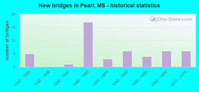
- New bridges - historical statistics
- 51930-1939
- 11950-1959
- 171960-1969
- 31970-1979
- 61980-1989
- 41990-1999
- 62000-2009
- 62010-2019


- Bridge Condition - Deck
- 20.0%Very good
- 40.0%Good
- 12.0%Satisfactory
- 24.0%Fair
- 4.0%Poor

- Bridge Condition - Superstructure
- 32.0%Very good
- 32.0%Good
- 8.0%Satisfactory
- 20.0%Fair
- 8.0%Poor

- Bridge Condition - Substructure
- 56.0%Very good
- 16.0%Good
- 16.0%Satisfactory
- 8.0%Fair
- 4.0%Poor

- Bridge Condition - Channel
- 51.9%Very good
- 37.0%Good
- 11.1%Satisfactory

- Bridge Condition - Culverts
- 63.6%Very good
- 36.4%Good
Find on map >> Show street view
Structure Number: 11000200610494A, Location: I 20 OVER SR 468 (Lat: 32.266364, Lng: -90.133939), Route carried "on" structure: Interstate 20, Year Built: 1967, Year Reconstructed: 2012, Status: Open, Structure Length: 6.77m (22.21ft), Average Daily Traffic: 33,500 (year 2020), Truck Traffic: 16%, Average Future Daily Traffic: 39,000 (year 2040), Design Load: HS 20, Features Intersected: SR 468
Minimum Vertical Clearance: 30+ m (98+ ft), Kilometerpoint: 39.292, Lanes on structure: 3, Lanes under structure: 6, Base Highway Network: Yes (Inventory Route: 2, Subroute: 1), Owner: State Highway Agency, Approaching Roadway Width: 18.3m (60.0ft), Material/Design: Prestressed concrete, Design/Construction: Stringer/Multi-beam, Number Of Spans In Main Unit: 4, Length of Maximum Span: 18.3m (60.0ft), Curb-To-Curb Width: 18.3m (60.0ft), Out-to-Out Width: 18.9m (62.0ft)
Condition: Deck: Good, Superstructure: Very good, Substructure: Very good, Operating Rating: 52.2 metric tons, Method Used To Determine Operating Rating: Load Factor (LF), Inventory Rating: 31.2 metric tons, Method Used To Determine Inventory Rating: Load Factor (LF), Structural Evaluation: Better than present minimum criteria, Deck Geometry: Better than present minimum criteria, Underclear: Somewhat better than minimum adequacy, Approach Roadway Alignment: Equal to present desirable criteria, Designated Inspection Frequency: Every 24 months, Inspection Date: November 2020, Deck Structure Type: Concrete Cast-file-Place
Find on map >> Show street view
Structure Number: 11000200610494B, Location: I 20 OVER SR 468 (Lat: 32.266061, Lng: -90.134572), Route carried "on" structure: Interstate 20, Year Built: 1967, Year Reconstructed: 2012, Status: Open, Structure Length: 6.77m (22.21ft), Average Daily Traffic: 33,500 (year 2020), Truck Traffic: 16%, Average Future Daily Traffic: 39,000 (year 2040), Design Load: HS 20, Features Intersected: SR 468
Minimum Vertical Clearance: 30+ m (98+ ft), Kilometerpoint: 4.377, Lanes on structure: 2, Lanes under structure: 6, Base Highway Network: Yes (Inventory Route: 2, Subroute: 1), Owner: State Highway Agency, Approaching Roadway Width: 13.4m (44.0ft), Material/Design: Prestressed concrete, Design/Construction: Stringer/Multi-beam, Number Of Spans In Main Unit: 4, Length of Maximum Span: 18.3m (60.0ft), Curb or Sidewalk Widths: Left: 0.2m (0.7ft), Right: 0.2m (0.7ft), Curb-To-Curb Width: 11.9m (39.0ft), Out-to-Out Width: 12.7m (41.7ft)
Condition: Deck: Very good, Superstructure: Good, Substructure: Very good, Operating Rating: 52.2 metric tons, Method Used To Determine Operating Rating: Load Factor (LF), Inventory Rating: 31.2 metric tons, Method Used To Determine Inventory Rating: Load Factor (LF), Structural Evaluation: Better than present minimum criteria, Deck Geometry: Equal to present minimum criteria, Underclear: Somewhat better than minimum adequacy, Approach Roadway Alignment: Equal to present desirable criteria, Designated Inspection Frequency: Every 24 months, Inspection Date: November 2020, Deck Structure Type: Concrete Cast-file-Place
Find on map >> Show street view
Structure Number: 21000800610469, Location: 0.2 MI E HINDS CL (Lat: 32.280678, Lng: -90.173511), Route carried "on" structure: US 80, Year Built: 1938, Status: Open, Structure Length: 10.97m (35.99ft), Average Daily Traffic: 16,000 (year 2020), Truck Traffic: 7%, Average Future Daily Traffic: 16,000 (year 2040), Design Load: H 15, Features Intersected: PEARL RIVER RELIEF
Minimum Vertical Clearance: 4.97m (16.31ft), Kilometerpoint: 0.394, Lanes on structure: 4, Base Highway Network: Yes (Inventory Route: 8, Subroute: 1), Owner: State Highway Agency, Approaching Roadway Width: 18.3m (60.0ft), Material/Design: Concrete, Design/Construction: Tee Beam, Number Of Spans In Main Unit: 9, Length of Maximum Span: 12.2m (40.0ft), Curb or Sidewalk Widths: Left: 0.2m (0.7ft), Right: 0.2m (0.7ft), Curb-To-Curb Width: 13.4m (44.0ft), Out-to-Out Width: 17.1m (56.1ft)
Condition: Deck: Satisfactory, Superstructure: Satisfactory, Substructure: Fair, Channel: Very good, Operating Rating: 38.5 metric tons, Method Used To Determine Operating Rating: Load Factor (LF), Inventory Rating: 23.1 metric tons, Method Used To Determine Inventory Rating: Load Factor (LF), Structural Evaluation: Somewhat better than minimum adequacy, Deck Geometry: High priority of replacement, Waterway Adequacy: Equal to present desirable criteria, Approach Roadway Alignment: Equal to present desirable criteria, Length Of Structure Improvement: 13.89m (45.57ft), Designated Inspection Frequency: Every 24 months, Inspection Date: November 2020, Bridge Improvement Cost: $999,999,000, Roadway Improvement Cost: $143,000,000, Total Project Cost: $999,999,000, Deck Structure Type: Concrete Cast-file-Place
Find on map >> Show street view
Structure Number: 21000800610472, Location: 0.5 MI E HINDS CL (Lat: 32.279672, Lng: -90.167750), Route carried "on" structure: US 80, Year Built: 1938, Status: Open, Structure Length: 12.50m (41.01ft), Average Daily Traffic: 17,000 (year 2020), Truck Traffic: 15%, Average Future Daily Traffic: 17,000 (year 2040), Design Load: H 15, Features Intersected: OVER OLD US 49, KCS RR
Minimum Vertical Clearance: 30+ m (98+ ft), Kilometerpoint: 0.948, Lanes on structure: 4, Lanes under structure: 2, Base Highway Network: Yes (Inventory Route: 8, Subroute: 1), Owner: State Highway Agency, Approaching Roadway Width: 18.3m (60.0ft), Material/Design: Steel, Design/Construction: Stringer/Multi-beam, Number Of Spans In Main Unit: 1, Number Of Approach Spans: 8, Length of Maximum Span: 27.4m (89.9ft), Curb or Sidewalk Widths: Left: 1.5m (4.9ft), Right: 1.5m (4.9ft), Curb-To-Curb Width: 13.4m (44.0ft), Out-to-Out Width: 17.1m (56.1ft)
Condition: Deck: Good, Superstructure: Good, Substructure: Satisfactory, Operating Rating: 38.5 metric tons, Method Used To Determine Operating Rating: Load Factor (LF), Inventory Rating: 23.1 metric tons, Method Used To Determine Inventory Rating: Load Factor (LF), Structural Evaluation: Somewhat better than minimum adequacy, Deck Geometry: High priority of replacement, Underclear: Superior to present desirable criteria, Approach Roadway Alignment: Equal to present desirable criteria, Length Of Structure Improvement: 15.74m (51.64ft), Designated Inspection Frequency: Every 24 months, Inspection Date: November 2020, Bridge Improvement Cost: $999,999,000, Roadway Improvement Cost: $163,000,000, Total Project Cost: $999,999,000, Deck Structure Type: Concrete Cast-file-Place
Find on map >> Show street view
Structure Number: 21000800610474, Location: 0.6 MI E HINDS CL (Lat: 32.279089, Lng: -90.164367), Route carried "on" structure: US 80, Year Built: 1938, Status: Open, Structure Length: 1.31m (4.30ft), Average Daily Traffic: 17,000 (year 2020), Truck Traffic: 15%, Average Future Daily Traffic: 17,000 (year 2040), Design Load: H 15, Features Intersected: DITCH
Minimum Vertical Clearance: 30+ m (98+ ft), Kilometerpoint: 1.275, Lanes on structure: 4, Base Highway Network: Yes (Inventory Route: 8, Subroute: 1), Owner: State Highway Agency, Approaching Roadway Width: 13.4m (44.0ft), Material/Design: Concrete, Design/Construction: Culvert, Number Of Spans In Main Unit: 4, Length of Maximum Span: 3.0m (9.8ft)
Condition: Channel: Very good, Culverts: Very good, Operating Rating: 73.4 metric tons, Method Used To Determine Operating Rating: Load Factor (LF), Inventory Rating: 44.0 metric tons, Method Used To Determine Inventory Rating: Load Factor (LF), Structural Evaluation: Equal to present desirable criteria, Waterway Adequacy: Equal to present desirable criteria, Approach Roadway Alignment: Equal to present desirable criteria, Length Of Structure Improvement: 1.31m (4.30ft), Designated Inspection Frequency: Every 24 months, Inspection Date: November 2020, Bridge Improvement Cost: $98,000,000, Roadway Improvement Cost: $200,000,000, Total Project Cost: $345,000,000
Find on map >> Show street view
Structure Number: 21000800610481, Location: 0.2 MI E JCT US 80 468 W (Lat: 32.277989, Lng: -90.153603), Route carried "on" structure: US 80, Year Built: 1938, Status: Open, Structure Length: 1.37m (4.49ft), Average Daily Traffic: 26,000 (year 2020), Truck Traffic: 7%, Average Future Daily Traffic: 26,000 (year 2040), Design Load: H 15, Features Intersected: DITCH
Minimum Vertical Clearance: 30+ m (98+ ft), Kilometerpoint: 2.300, Lanes on structure: 6, Base Highway Network: Yes (Inventory Route: 8, Subroute: 1), Owner: State Highway Agency, Approaching Roadway Width: 9.1m (29.9ft), Material/Design: Concrete, Design/Construction: Culvert, Number Of Spans In Main Unit: 3, Length of Maximum Span: 4.3m (14.1ft)
Condition: Channel: Very good, Culverts: Very good, Operating Rating: 74.8 metric tons, Method Used To Determine Operating Rating: Load Factor (LF), Inventory Rating: 44.9 metric tons, Method Used To Determine Inventory Rating: Load Factor (LF), Structural Evaluation: Equal to present desirable criteria, Waterway Adequacy: Equal to present desirable criteria, Approach Roadway Alignment: Equal to present desirable criteria, Length Of Structure Improvement: 1.37m (4.49ft), Designated Inspection Frequency: Every 24 months, Inspection Date: November 2020, Bridge Improvement Cost: $102,000,000, Roadway Improvement Cost: $200,000,000, Total Project Cost: $351,000,000, Deck Structure Type: Concrete Cast-file-Place
Find on map >> Show street view
Structure Number: 21000800610486, Location: 0.1 MI S US 80 @ JCT 468S (Lat: 32.277858, Lng: -90.144472), Route carried "on" structure: City street , Year Built: 1977, Status: Posted for load, Structure Length: 1.77m (5.81ft), Average Daily Traffic: 3,200 (year 2020), Truck Traffic: 6%, Average Future Daily Traffic: 3,200 (year 2040), Design Load: H 15, Features Intersected: CONWAY SLOUGH, Facility Carried by Structure: OLD BRANDON RD
Minimum Vertical Clearance: 30+ m (98+ ft), Kilometerpoint: 0.105, Lanes on structure: 2, Owner: State Highway Agency, Approaching Roadway Width: 9.1m (29.9ft), Material/Design: Concrete, Design/Construction: Channel Beam, Number Of Spans In Main Unit: 3, Length of Maximum Span: 5.8m (19.0ft), Curb-To-Curb Width: 7.0m (23.0ft), Out-to-Out Width: 7.5m (24.6ft)
Condition: Deck: Fair, Superstructure: Fair, Substructure: Poor, Channel: Very good, Operating Rating: 18.3 metric tons, Method Used To Determine Operating Rating: Allowable Stress (AS), Inventory Rating: 13.7 metric tons, Method Used To Determine Inventory Rating: Allowable Stress (AS), Structural Evaluation: Meets minimum limits, Deck Geometry: High priority of replacement, Waterway Adequacy: Equal to present desirable criteria, Approach Roadway Alignment: Equal to present desirable criteria, Bridge Posting: Required (Relationship of Operating Rating to Maximum Legal Load: 30.0 - 39.9% below), Length Of Structure Improvement: 3.54m (11.61ft), Designated Inspection Frequency: Every 12 months, Inspection Date: December 2021, Bridge Improvement Cost: $264,000,000, Roadway Improvement Cost: $26,000,000, Total Project Cost: $794,000,000, Deck Structure Type: Concrete Precast Panels
Find on map >> Show street view
Structure Number: 21000800610487, Location: 0.1 MI W 468 S (Lat: 32.278733, Lng: -90.143822), Route carried "on" structure: US 80, Year Built: 1938, Status: Open, Structure Length: 1.04m (3.41ft), Average Daily Traffic: 12,000 (year 2020), Truck Traffic: 9%, Average Future Daily Traffic: 12,000 (year 2040), Design Load: H 15, Features Intersected: CONWAY SLOUGH
Minimum Vertical Clearance: 30+ m (98+ ft), Kilometerpoint: 3.228, Lanes on structure: 4, Base Highway Network: Yes (Inventory Route: 8, Subroute: 1), Owner: State Highway Agency, Approaching Roadway Width: 10.3m (33.8ft), Material/Design: Concrete, Design/Construction: Culvert, Number Of Spans In Main Unit: 2, Length of Maximum Span: 4.9m (16.1ft)
Condition: Channel: Good, Culverts: Good, Operating Rating: 36.5 metric tons, Method Used To Determine Operating Rating: Load Factor (LF), Inventory Rating: 21.9 metric tons, Method Used To Determine Inventory Rating: Load Factor (LF), Structural Evaluation: Somewhat better than minimum adequacy, Waterway Adequacy: Equal to present desirable criteria, Approach Roadway Alignment: Equal to present desirable criteria, Length Of Structure Improvement: 1.04m (3.41ft), Designated Inspection Frequency: Every 24 months, Inspection Date: November 2020, Bridge Improvement Cost: $77,000,000, Roadway Improvement Cost: $200,000,000, Total Project Cost: $321,000,000, Deck Structure Type: Concrete Cast-file-Place
Find on map >> Show street view
Structure Number: 21000800610498, Location: 0.7 MI E 468 S (Lat: 32.281517, Lng: -90.126486), Route carried "on" structure: US 80, Year Built: 1989, Status: Open, Structure Length: 1.62m (5.31ft), Average Daily Traffic: 20,000 (year 2020), Truck Traffic: 4%, Average Future Daily Traffic: 20,000 (year 2040), Design Load: HS 20, Features Intersected: NEELY CREEK
Minimum Vertical Clearance: 30+ m (98+ ft), Kilometerpoint: 4.892, Lanes on structure: 7, Base Highway Network: Yes (Inventory Route: 8, Subroute: 1), Owner: State Highway Agency, Approaching Roadway Width: 28.6m (93.8ft), Skew: 4 degrees, Material/Design: Concrete, Design/Construction: Culvert, Number Of Spans In Main Unit: 3, Length of Maximum Span: 3.7m (12.1ft)
Condition: Channel: Very good, Culverts: Very good, Operating Rating: 49.2 metric tons, Method Used To Determine Operating Rating: Load Factor (LF), Inventory Rating: 29.5 metric tons, Method Used To Determine Inventory Rating: Load Factor (LF), Structural Evaluation: Better than present minimum criteria, Waterway Adequacy: Equal to present desirable criteria, Approach Roadway Alignment: Equal to present desirable criteria, Designated Inspection Frequency: Every 24 months, Inspection Date: November 2020
Find on map >> Show street view
Structure Number: 31004680610069, Location: 2.6 MI S I 20 (Lat: 32.242939, Lng: -90.108117), Route carried "on" structure: State highway 468, Year Built: 1966, Status: Open, Structure Length: 0.82m (2.69ft), Average Daily Traffic: 5,700 (year 2020), Truck Traffic: 6%, Average Future Daily Traffic: 5,700 (year 2040), Design Load: HS 15, Features Intersected: DITCH
Minimum Vertical Clearance: 30+ m (98+ ft), Kilometerpoint: 15.147, Lanes on structure: 2, Owner: State Highway Agency, Approaching Roadway Width: 9.1m (29.9ft), Skew: 1 degrees, Material/Design: Concrete, Design/Construction: Culvert, Number Of Spans In Main Unit: 2, Length of Maximum Span: 3.7m (12.1ft)
Condition: Channel: Good, Culverts: Very good, Operating Rating: 40.7 metric tons, Method Used To Determine Operating Rating: Load Factor (LF), Inventory Rating: 23.6 metric tons, Method Used To Determine Inventory Rating: Load Factor (LF), Structural Evaluation: Somewhat better than minimum adequacy, Waterway Adequacy: Equal to present desirable criteria, Approach Roadway Alignment: Equal to present desirable criteria, Designated Inspection Frequency: Every 24 months, Inspection Date: October 2020
Find on map >> Show street view
Structure Number: 3100468061009, Location: 4.3 MI S I 20 (Lat: 32.236875, Lng: -90.079672), Route carried "on" structure: State highway 468, Year Built: 1966, Status: Open, Structure Length: 0.91m (2.99ft), Average Daily Traffic: 5,700 (year 2020), Truck Traffic: 6%, Average Future Daily Traffic: 5,700 (year 2040), Design Load: HS 15, Features Intersected: DITCH
Minimum Vertical Clearance: 30+ m (98+ ft), Kilometerpoint: 17.968, Lanes on structure: 2, Owner: State Highway Agency, Approaching Roadway Width: 8.5m (27.9ft), Skew: 3 degrees, Material/Design: Concrete, Design/Construction: Culvert, Number Of Spans In Main Unit: 2, Length of Maximum Span: 3.7m (12.1ft)
Condition: Channel: Good, Culverts: Very good, Operating Rating: 40.9 metric tons, Method Used To Determine Operating Rating: Load Factor (LF), Inventory Rating: 24.5 metric tons, Method Used To Determine Inventory Rating: Load Factor (LF), Structural Evaluation: Equal to present minimum criteria, Waterway Adequacy: Equal to present desirable criteria, Approach Roadway Alignment: Equal to present desirable criteria, Designated Inspection Frequency: Every 24 months, Inspection Date: October 2020
Find on map >> Show street view
Structure Number: 310046806101, Location: 0.7 MI E SR 475 (Lat: 32.234275, Lng: -90.066175), Route carried "on" structure: State highway 468, Year Built: 2012, Status: Open, Structure Length: 6.14m (20.14ft), Average Daily Traffic: 6,800 (year 2020), Truck Traffic: 6%, Average Future Daily Traffic: 6,800 (year 2040), Design Load: HL 93, Features Intersected: TERRAPIN SKIN CREEK
Minimum Vertical Clearance: 30+ m (98+ ft), Kilometerpoint: 19.405, Lanes on structure: 2, Owner: State Highway Agency, Approaching Roadway Width: 13.4m (44.0ft), Material/Design: Prestressed concrete continuous, Design/Construction: Stringer/Multi-beam, Number Of Spans In Main Unit: 5, Length of Maximum Span: 12.2m (40.0ft), Curb-To-Curb Width: 13.4m (44.0ft), Out-to-Out Width: 14.3m (46.9ft)
Condition: Deck: Very good, Superstructure: Very good, Substructure: Very good, Channel: Very good, Operating Rating: 51.4 metric tons, Method Used To Determine Operating Rating: Load and Resistance Factor (LRFR), Inventory Rating: 38.6 metric tons, Method Used To Determine Inventory Rating: Load and Resistance Factor (LRFR), Structural Evaluation: Equal to present desirable criteria, Deck Geometry: Equal to present minimum criteria, Waterway Adequacy: Equal to present desirable criteria, Approach Roadway Alignment: Equal to present desirable criteria, Designated Inspection Frequency: Every 24 months, Inspection Date: October 2020, Deck Structure Type: Concrete Cast-file-Place
Find on map >> Show street view
Structure Number: 31004690610292, Location: 1.5 MI S SR 468 (Lat: 32.207447, Lng: -90.053169), Route carried "on" structure: State highway 469, Year Built: 1986, Status: Open, Structure Length: 3.66m (12.01ft), Average Daily Traffic: 4,500 (year 2020), Truck Traffic: 6%, Average Future Daily Traffic: 4,500 (year 2040), Design Load: HS 20, Features Intersected: RELIEF
Minimum Vertical Clearance: 30+ m (98+ ft), Kilometerpoint: 23.150, Lanes on structure: 2, Owner: State Highway Agency, Approaching Roadway Width: 11.0m (36.1ft), Material/Design: Prestressed concrete, Design/Construction: Slab, Number Of Spans In Main Unit: 3, Length of Maximum Span: 12.2m (40.0ft), Curb-To-Curb Width: 11.0m (36.1ft), Out-to-Out Width: 11.8m (38.7ft)
Condition: Deck: Good, Superstructure: Good, Substructure: Very good, Channel: Very good, Operating Rating: 61.3 metric tons, Method Used To Determine Operating Rating: Load Factor (LF), Inventory Rating: 36.7 metric tons, Method Used To Determine Inventory Rating: Load Factor (LF), Structural Evaluation: Better than present minimum criteria, Deck Geometry: Somewhat better than minimum adequacy, Waterway Adequacy: Equal to present desirable criteria, Approach Roadway Alignment: Equal to present desirable criteria, Designated Inspection Frequency: Every 24 months, Inspection Date: October 2020, Deck Structure Type: Concrete Cast-file-Place
Find on map >> Show street view
Structure Number: 31004690610293, Location: 1.4 MI S SR 468 (Lat: 32.208650, Lng: -90.051558), Route carried "on" structure: State highway 469, Year Built: 1986, Status: Open, Structure Length: 3.66m (12.01ft), Average Daily Traffic: 4,500 (year 2020), Truck Traffic: 6%, Average Future Daily Traffic: 4,500 (year 2040), Design Load: HS 20, Features Intersected: RELIEF
Minimum Vertical Clearance: 30+ m (98+ ft), Kilometerpoint: 23.353, Lanes on structure: 2, Owner: State Highway Agency, Approaching Roadway Width: 11.0m (36.1ft), Material/Design: Prestressed concrete, Design/Construction: Slab, Number Of Spans In Main Unit: 3, Length of Maximum Span: 12.2m (40.0ft), Curb-To-Curb Width: 11.0m (36.1ft), Out-to-Out Width: 11.8m (38.7ft)
Condition: Deck: Good, Superstructure: Good, Substructure: Very good, Channel: Very good, Operating Rating: 61.3 metric tons, Method Used To Determine Operating Rating: Load Factor (LF), Inventory Rating: 36.7 metric tons, Method Used To Determine Inventory Rating: Load Factor (LF), Structural Evaluation: Better than present minimum criteria, Deck Geometry: Somewhat better than minimum adequacy, Waterway Adequacy: Equal to present desirable criteria, Approach Roadway Alignment: Equal to present desirable criteria, Designated Inspection Frequency: Every 24 months, Inspection Date: October 2020, Deck Structure Type: Concrete Cast-file-Place
Find on map >> Show street view
Structure Number: 31004690610295, Location: 1.2 MI S SR 468 (Lat: 32.210525, Lng: -90.049031), Route carried "on" structure: State highway 469, Year Built: 1986, Status: Open, Structure Length: 4.88m (16.01ft), Average Daily Traffic: 4,500 (year 2020), Truck Traffic: 6%, Average Future Daily Traffic: 4,500 (year 2040), Design Load: HS 20, Features Intersected: RELIEF
Minimum Vertical Clearance: 30+ m (98+ ft), Kilometerpoint: 23.669, Lanes on structure: 2, Owner: State Highway Agency, Approaching Roadway Width: 11.0m (36.1ft), Material/Design: Prestressed concrete, Design/Construction: Slab, Number Of Spans In Main Unit: 4, Length of Maximum Span: 12.2m (40.0ft), Curb-To-Curb Width: 11.0m (36.1ft), Out-to-Out Width: 11.8m (38.7ft)
Condition: Deck: Fair, Superstructure: Fair, Substructure: Satisfactory, Channel: Very good, Operating Rating: 61.3 metric tons, Method Used To Determine Operating Rating: Load Factor (LF), Inventory Rating: 36.7 metric tons, Method Used To Determine Inventory Rating: Load Factor (LF), Structural Evaluation: Somewhat better than minimum adequacy, Deck Geometry: Somewhat better than minimum adequacy, Waterway Adequacy: Equal to present desirable criteria, Approach Roadway Alignment: Equal to present desirable criteria, Designated Inspection Frequency: Every 24 months, Inspection Date: October 2020, Deck Structure Type: Concrete Cast-file-Place
Find on map >> Show street view
Structure Number: 31004690610298, Location: 0.8 MI S SR 468 (Lat: 32.214661, Lng: -90.045347), Route carried "on" structure: State highway 469, Year Built: 1986, Status: Open, Structure Length: 4.88m (16.01ft), Average Daily Traffic: 4,500 (year 2020), Truck Traffic: 6%, Average Future Daily Traffic: 4,500 (year 2040), Design Load: HS 20, Features Intersected: RELIEF
Minimum Vertical Clearance: 30+ m (98+ ft), Kilometerpoint: 24.248, Lanes on structure: 2, Owner: State Highway Agency, Approaching Roadway Width: 11.0m (36.1ft), Material/Design: Prestressed concrete, Design/Construction: Slab, Number Of Spans In Main Unit: 4, Length of Maximum Span: 12.2m (40.0ft), Curb-To-Curb Width: 11.0m (36.1ft), Out-to-Out Width: 11.8m (38.7ft)
Condition: Deck: Fair, Superstructure: Fair, Substructure: Fair, Channel: Very good, Operating Rating: 61.3 metric tons, Method Used To Determine Operating Rating: Load Factor (LF), Inventory Rating: 36.7 metric tons, Method Used To Determine Inventory Rating: Load Factor (LF), Structural Evaluation: Somewhat better than minimum adequacy, Deck Geometry: Somewhat better than minimum adequacy, Waterway Adequacy: Equal to present desirable criteria, Approach Roadway Alignment: Equal to present desirable criteria, Designated Inspection Frequency: Every 24 months, Inspection Date: October 2020, Deck Structure Type: Concrete Cast-file-Place
Find on map >> Show street view
Structure Number: 31004710610006, Location: SR 471 OVER I 20 (Lat: 32.278733, Lng: -89.993553), Route carried "on" structure: State highway 471, Year Built: 2016, Status: Open, Structure Length: 11.53m (37.83ft), Average Daily Traffic: 13,000 (year 2020), Truck Traffic: 9%, Average Future Daily Traffic: 13,000 (year 2040), Design Load: HL 93, Features Intersected: I 20
Minimum Vertical Clearance: 30+ m (98+ ft), Kilometerpoint: 0.526, Lanes on structure: 5, Lanes under structure: 4, Base Highway Network: Yes (Inventory Route: 47, Subroute: 1), Owner: State Highway Agency, Approaching Roadway Width: 24.4m (80.1ft), Material/Design: Prestressed concrete continuous, Design/Construction: Stringer/Multi-beam, Number Of Spans In Main Unit: 2, Number Of Approach Spans: 2, Length of Maximum Span: 31.1m (102.0ft), Curb-To-Curb Width: 24.4m (80.1ft), Out-to-Out Width: 25.3m (83.0ft)
Condition: Deck: Very good, Superstructure: Very good, Substructure: Very good, Operating Rating: 60.0 metric tons, Method Used To Determine Operating Rating: Load and Resistance Factor (LRFR), Inventory Rating: 45.3 metric tons, Method Used To Determine Inventory Rating: Load and Resistance Factor (LRFR), Structural Evaluation: Equal to present desirable criteria, Deck Geometry: Superior to present desirable criteria, Underclear: Equal to present minimum criteria, Approach Roadway Alignment: Equal to present desirable criteria, Designated Inspection Frequency: Every 24 months, Inspection Date: October 2020, Deck Structure Type: Concrete Cast-file-Place
Find on map >> Show street view
Structure Number: 31004750610004, Location: 0.4 MI N SR 468 (Lat: 32.242608, Lng: -90.078125), Route carried "on" structure: State highway 475, Year Built: 1979, Status: Open, Structure Length: 0.94m (3.08ft), Average Daily Traffic: 11,000 (year 2020), Truck Traffic: 6%, Average Future Daily Traffic: 11,000 (year 2040), Design Load: HS 20, Features Intersected: DITCH
Minimum Vertical Clearance: 30+ m (98+ ft), Kilometerpoint: 0.607, Lanes on structure: 2, Owner: State Highway Agency, Approaching Roadway Width: 12.8m (42.0ft), Skew: 4 degrees, Material/Design: Concrete, Design/Construction: Culvert, Number Of Spans In Main Unit: 2, Length of Maximum Span: 3.0m (9.8ft)
Condition: Channel: Very good, Culverts: Very good, Operating Rating: 43.9 metric tons, Method Used To Determine Operating Rating: Load Factor (LF), Inventory Rating: 26.2 metric tons, Method Used To Determine Inventory Rating: Load Factor (LF), Structural Evaluation: Equal to present minimum criteria, Waterway Adequacy: Equal to present desirable criteria, Approach Roadway Alignment: Equal to present desirable criteria, Designated Inspection Frequency: Every 24 months, Inspection Date: October 2020
Find on map >> Show street view
Structure Number: 31004750610007, Location: 0.7 MI N SR 468 (Lat: 32.246856, Lng: -90.079964), Route carried "on" structure: State highway 475, Year Built: 1979, Status: Open, Structure Length: 1.13m (3.71ft), Average Daily Traffic: 11,000 (year 2020), Truck Traffic: 6%, Average Future Daily Traffic: 11,000 (year 2040), Design Load: HS 20, Features Intersected: DITCH
Minimum Vertical Clearance: 30+ m (98+ ft), Kilometerpoint: 1.107, Lanes on structure: 2, Owner: State Highway Agency, Approaching Roadway Width: 12.8m (42.0ft), Skew: 4 degrees, Material/Design: Concrete, Design/Construction: Culvert, Number Of Spans In Main Unit: 2, Length of Maximum Span: 3.7m (12.1ft)
Condition: Channel: Very good, Culverts: Very good, Operating Rating: 46.3 metric tons, Method Used To Determine Operating Rating: Load Factor (LF), Inventory Rating: 27.7 metric tons, Method Used To Determine Inventory Rating: Load Factor (LF), Structural Evaluation: Equal to present minimum criteria, Waterway Adequacy: Equal to present desirable criteria, Approach Roadway Alignment: Equal to present desirable criteria, Designated Inspection Frequency: Every 24 months, Inspection Date: October 2020
Find on map >> Show street view
Structure Number: 31004750610025A, Location: SR 475 OVER I 20 (Lat: 32.271836, Lng: -90.073253), Route carried "on" structure: State highway 475, Year Built: 1967, Status: Open, Structure Length: 9.51m (31.20ft), Average Daily Traffic: 5,500 (year 2020), Truck Traffic: 6%, Average Future Daily Traffic: 5,500 (year 2040), Design Load: HS 20, Features Intersected: I 20
Minimum Vertical Clearance: 30+ m (98+ ft), Kilometerpoint: 7.506, Lanes on structure: 2, Lanes under structure: 4, Base Highway Network: Yes (Inventory Route: 47, Subroute: 2), Owner: State Highway Agency, Approaching Roadway Width: 12.5m (41.0ft), Skew: 3 degrees, Material/Design: Concrete continuous, Design/Construction: Box Beam or Girders - Single/Spread, Number Of Spans In Main Unit: 4, Length of Maximum Span: 27.4m (89.9ft), Curb or Sidewalk Widths: Left: 0.5m (1.6ft), Right: 0.5m (1.6ft), Curb-To-Curb Width: 8.5m (27.9ft), Out-to-Out Width: 9.8m (32.2ft)
Condition: Deck: Fair, Superstructure: Fair, Substructure: Very good, Inventory Rating: 65.1 metric tons, Method Used To Determine Inventory Rating: Load Factor (LF), Structural Evaluation: Somewhat better than minimum adequacy, Deck Geometry: High priority of corrective action, Underclear: Equal to present minimum criteria, Approach Roadway Alignment: Equal to present desirable criteria, Length Of Structure Improvement: 10.50m (34.45ft), Designated Inspection Frequency: Every 24 months, Inspection Date: October 2020, Bridge Improvement Cost: $941,000,000, Roadway Improvement Cost: $94,000,000, Total Project Cost: $999,999,000, Deck Structure Type: Concrete Cast-file-Place
Find on map >> Show street view
Structure Number: 31004750610025B, Location: SR 475 OVER I 20 (Lat: 32.271058, Lng: -90.073350), Route carried "on" structure: State highway 475, Year Built: 1967, Status: Open, Structure Length: 9.51m (31.20ft), Average Daily Traffic: 6,000 (year 2020), Truck Traffic: 4%, Average Future Daily Traffic: 6,000 (year 2040), Design Load: HS 20, Features Intersected: I 20
Minimum Vertical Clearance: 30+ m (98+ ft), Kilometerpoint: 3.998, Lanes on structure: 2, Lanes under structure: 4, Base Highway Network: Yes (Inventory Route: 47, Subroute: 1), Owner: State Highway Agency, Approaching Roadway Width: 12.5m (41.0ft), Skew: 3 degrees, Material/Design: Concrete continuous, Design/Construction: Box Beam or Girders - Single/Spread, Number Of Spans In Main Unit: 4, Length of Maximum Span: 0.0m, Curb or Sidewalk Widths: Left: 0.5m (1.6ft), Right: 0.5m (1.6ft), Curb-To-Curb Width: 8.5m (27.9ft), Out-to-Out Width: 10.0m (32.8ft)
Condition: Deck: Fair, Superstructure: Fair, Substructure: Very good, Inventory Rating: 65.1 metric tons, Method Used To Determine Inventory Rating: Load Factor (LF), Structural Evaluation: Somewhat better than minimum adequacy, Deck Geometry: High priority of corrective action, Underclear: Somewhat better than minimum adequacy, Approach Roadway Alignment: Equal to present desirable criteria, Length Of Structure Improvement: 9.51m (31.20ft), Designated Inspection Frequency: Every 24 months, Inspection Date: October 2020, Bridge Improvement Cost: $506,000,000, Roadway Improvement Cost: $200,000,000, Total Project Cost: $847,000,000, Deck Structure Type: Concrete Cast-file-Place
Find on map >> Show street view
Structure Number: 31004750610038A, Location: 0.5 MI N US 80 (Lat: 32.291067, Lng: -90.076267), Route carried "on" structure: State highway 475, Year Built: 2013, Status: Open, Structure Length: 9.78m (32.09ft), Average Daily Traffic: 9,500 (year 2020), Truck Traffic: 8%, Average Future Daily Traffic: 9,500 (year 2040), Design Load: HL 93, Features Intersected: OLD BRANDON ROAD
Minimum Vertical Clearance: 30+ m (98+ ft), Kilometerpoint: 5.601, Lanes on structure: 2, Lanes under structure: 2, Base Highway Network: Yes (Inventory Route: 47, Subroute: 1), Owner: State Highway Agency, Approaching Roadway Width: 12.8m (42.0ft), Material/Design: Prestressed concrete, Design/Construction: Stringer/Multi-beam, Number Of Spans In Main Unit: 1, Number Of Approach Spans: 3, Length of Maximum Span: 28.3m (92.8ft), Curb-To-Curb Width: 12.8m (42.0ft), Out-to-Out Width: 13.7m (44.9ft)
Condition: Deck: Very good, Superstructure: Very good, Substructure: Very good, Operating Rating: 54.8 metric tons, Method Used To Determine Operating Rating: Load and Resistance Factor (LRFR), Inventory Rating: 42.3 metric tons, Method Used To Determine Inventory Rating: Load and Resistance Factor (LRFR), Structural Evaluation: Equal to present desirable criteria, Deck Geometry: Equal to present desirable criteria, Underclear: Superior to present desirable criteria, Approach Roadway Alignment: Equal to present desirable criteria, Designated Inspection Frequency: Every 24 months, Inspection Date: October 2020, Deck Structure Type: Concrete Cast-file-Place
Find on map >> Show street view
Structure Number: 31004750610038B, Location: 0.5 MI N US 80 (Lat: 32.290250, Lng: -90.075447), Route carried "on" structure: State highway 475, Year Built: 2013, Status: Open, Structure Length: 10.07m (33.04ft), Average Daily Traffic: 9,500 (year 2020), Truck Traffic: 8%, Average Future Daily Traffic: 9,500 (year 2040), Design Load: HL 93, Features Intersected: OLD BRANDON ROAD
Minimum Vertical Clearance: 30+ m (98+ ft), Kilometerpoint: 6.202, Lanes on structure: 2, Lanes under structure: 2, Base Highway Network: Yes (Inventory Route: 47, Subroute: 1), Owner: State Highway Agency, Approaching Roadway Width: 12.8m (42.0ft), Material/Design: Prestressed concrete, Design/Construction: Stringer/Multi-beam, Number Of Spans In Main Unit: 2, Number Of Approach Spans: 2, Length of Maximum Span: 27.1m (88.9ft), Curb-To-Curb Width: 12.8m (42.0ft), Out-to-Out Width: 13.7m (44.9ft)
Condition: Deck: Very good, Superstructure: Very good, Substructure: Very good, Operating Rating: 53.5 metric tons, Method Used To Determine Operating Rating: Load and Resistance Factor (LRFR), Inventory Rating: 41.3 metric tons, Method Used To Determine Inventory Rating: Load and Resistance Factor (LRFR), Structural Evaluation: Equal to present desirable criteria, Deck Geometry: Equal to present desirable criteria, Underclear: Superior to present desirable criteria, Approach Roadway Alignment: Equal to present desirable criteria, Designated Inspection Frequency: Every 24 months, Inspection Date: October 2020, Deck Structure Type: Concrete Cast-file-Place
Find on map >> Show street view
Structure Number: 41000200610486, Location: 0.8 MI E US 49 (Lat: 32.266489, Lng: -90.147175), Route carried "on" structure: County highway , Year Built: 1967, Status: Open, Structure Length: 8.72m (28.61ft), Average Daily Traffic: 2,300 (year 2020), Truck Traffic: 5%, Average Future Daily Traffic: 2,300 (year 2040), Design Load: HS 15, Features Intersected: I 20, Facility Carried by Structure: CHILDRE ROAD
Minimum Vertical Clearance: 30+ m (98+ ft), Kilometerpoint: 1.049, Lanes on structure: 2, Lanes under structure: 6, Owner: State Highway Agency, Approaching Roadway Width: 8.5m (27.9ft), Skew: 2 degrees, Material/Design: Concrete continuous, Design/Construction: Box Beam or Girders - Single/Spread, Number Of Spans In Main Unit: 4, Length of Maximum Span: 25.0m (82.0ft), Curb or Sidewalk Widths: Left: 0.5m (1.6ft), Right: 0.5m (1.6ft), Curb-To-Curb Width: 7.3m (24.0ft), Out-to-Out Width: 8.8m (28.9ft)
Condition: Deck: Satisfactory, Superstructure: Satisfactory, Substructure: Very good, Operating Rating: 90.4 metric tons, Method Used To Determine Operating Rating: Load Factor (LF), Inventory Rating: 54.4 metric tons, Method Used To Determine Inventory Rating: Load Factor (LF), Structural Evaluation: Equal to present minimum criteria, Deck Geometry: High priority of replacement, Underclear: Somewhat better than minimum adequacy, Approach Roadway Alignment: Equal to present desirable criteria, Length Of Structure Improvement: 8.72m (28.61ft), Designated Inspection Frequency: Every 24 months, Inspection Date: November 2020, Bridge Improvement Cost: $195,000,000, Roadway Improvement Cost: $200,000,000, Total Project Cost: $458,000,000, Deck Structure Type: Concrete Cast-file-Place
Find on map >> Show street view
Structure Number: SA6100000000081, Location: SEC 7 T 5N R 2E (Lat: 32.284972, Lng: -90.129222), Route carried "on" structure: City street 2135, Year Built: 2003, Status: Open, Structure Length: 2.10m (6.89ft), Average Daily Traffic: 180 (year 2020), Truck Traffic: 20%, Average Future Daily Traffic: 270 (year 2040), Design Load: HS 20, Features Intersected: NEELY CREEK, Facility Carried by Structure: PREISTER DRIVE
Minimum Vertical Clearance: 30+ m (98+ ft), Kilometerpoint: 0.160, Lanes on structure: 2, Owner: City or Municipal Highway Agency, Approaching Roadway Width: 7.3m (24.0ft), Material/Design: Concrete, Design/Construction: Channel Beam, Number Of Spans In Main Unit: 3, Length of Maximum Span: 9.4m (30.8ft), Curb or Sidewalk Widths: Left: 0.5m (1.6ft), Right: 0.5m (1.6ft), Curb-To-Curb Width: 8.5m (27.9ft), Out-to-Out Width: 9.5m (31.2ft)
Condition: Deck: Good, Superstructure: Very good, Substructure: Very good, Channel: Good, Operating Rating: 63.1 metric tons, Method Used To Determine Operating Rating: Load Factor (LF), Inventory Rating: 37.9 metric tons, Method Used To Determine Inventory Rating: Load Factor (LF), Structural Evaluation: Equal to present desirable criteria, Deck Geometry: Equal to present minimum criteria, Waterway Adequacy: Equal to present desirable criteria, Approach Roadway Alignment: Equal to present desirable criteria, Designated Inspection Frequency: Every 24 months, Inspection Date: November 2020, Deck Structure Type: Concrete Precast Panels, Wearing Surface/Protective System: Wearing Surface: Monolithic Concrete
Find on map >> Show street view
Structure Number: SA6100000000082, Location: SEC 8 T 5N R 2E (Lat: 32.286333, Lng: -90.112528), Route carried "on" structure: City street 1140, Year Built: 1958, Status: Posted for load, Structure Length: 0.77m (2.53ft), Average Daily Traffic: 3,400 (year 2021), Truck Traffic: 8%, Average Future Daily Traffic: 5,100 (year 2041), Design Load: H 15, Features Intersected: DITCH, Facility Carried by Structure: BARNETT STREET
Minimum Vertical Clearance: 30+ m (98+ ft), Kilometerpoint: 0.482, Lanes on structure: 2, Owner: City or Municipal Highway Agency, Approaching Roadway Width: 8.2m (26.9ft), Material/Design: Concrete, Design/Construction: Tee Beam, Number Of Spans In Main Unit: 2, Length of Maximum Span: 3.9m (12.8ft), Curb or Sidewalk Widths: Left: 0.2m (0.7ft), Right: 0.2m (0.7ft), Curb-To-Curb Width: 9.0m (29.5ft), Out-to-Out Width: 9.4m (30.8ft)
Condition: Deck: Fair, Superstructure: Poor, Substructure: Satisfactory, Channel: Satisfactory, Operating Rating: 22.3 metric tons, Method Used To Determine Operating Rating: Load Factor (LF), Inventory Rating: 13.4 metric tons, Method Used To Determine Inventory Rating: Load Factor (LF), Structural Evaluation: Meets minimum limits, Deck Geometry: Meets minimum limits, Waterway Adequacy: Better than present minimum criteria, Approach Roadway Alignment: Equal to present desirable criteria, Bridge Posting: Required (Relationship of Operating Rating to Maximum Legal Load: 30.0 - 39.9% below), Length Of Structure Improvement: 1.74m (5.71ft), Designated Inspection Frequency: Every 12 months, Inspection Date: November 2021, Bridge Improvement Cost: $103,000, Roadway Improvement Cost: $10,000, Total Project Cost: $127,000 ( Estimate for 2021), Deck Structure Type: Concrete Cast-file-Place, Wearing Surface/Protective System: Wearing Surface: Bituminous
Find on map >> Show street view
Structure Number: SA6100000000083, Location: SEC 9 T 5N R 2E (Lat: 32.294639, Lng: -90.104556), Route carried "on" structure: City street 1123, Year Built: 2000, Status: Posted for load, Structure Length: 0.71m (2.33ft), Average Daily Traffic: 1,500 (year 2020), Truck Traffic: 20%, Average Future Daily Traffic: 2,250 (year 2040), Design Load: HS 20, Features Intersected: NEELY CREEK, Facility Carried by Structure: HARLE ST
Minimum Vertical Clearance: 30+ m (98+ ft), Kilometerpoint: 1.287, Lanes on structure: 2, Owner: City or Municipal Highway Agency, Approaching Roadway Width: 6.7m (22.0ft), Material/Design: Concrete, Design/Construction: Culvert, Number Of Spans In Main Unit: 2, Length of Maximum Span: 3.0m (9.8ft)
Condition: Channel: Good, Culverts: Good, Operating Rating: 69.9 metric tons, Method Used To Determine Operating Rating: Load Factor (LF), Inventory Rating: 41.8 metric tons, Method Used To Determine Inventory Rating: Load Factor (LF), Structural Evaluation: Better than present minimum criteria, Waterway Adequacy: Equal to present minimum criteria, Approach Roadway Alignment: Equal to present desirable criteria, Designated Inspection Frequency: Every 24 months, Inspection Date: November 2020
Find on map >> Show street view
Structure Number: SA6100000000084, Location: SEC 10 T 5N R 2E (Lat: 32.298250, Lng: -90.091611), Route carried "on" structure: City street 7336, Year Built: 2004, Status: Open, Structure Length: 1.74m (5.71ft), Average Daily Traffic: 2,300 (year 2021), Truck Traffic: 8%, Average Future Daily Traffic: 3,450 (year 2041), Design Load: H 15, Features Intersected: NEELY CREEK, Facility Carried by Structure: FOX HALL ROAD
Minimum Vertical Clearance: 30+ m (98+ ft), Kilometerpoint: 3.218, Lanes on structure: 2, Owner: City or Municipal Highway Agency, Approaching Roadway Width: 6.4m (21.0ft), Material/Design: Concrete, Design/Construction: Channel Beam, Number Of Spans In Main Unit: 3, Length of Maximum Span: 5.8m (19.0ft), Curb or Sidewalk Widths: Left: 0.2m (0.7ft), Right: 0.2m (0.7ft), Curb-To-Curb Width: 8.1m (26.6ft), Out-to-Out Width: 8.5m (27.9ft)
Condition: Deck: Poor, Superstructure: Poor, Substructure: Satisfactory, Channel: Satisfactory, Operating Rating: 40.0 metric tons, Method Used To Determine Operating Rating: Load Factor (LF), Inventory Rating: 18.3 metric tons, Method Used To Determine Inventory Rating: Load Factor (LF), Structural Evaluation: Meets minimum limits, Deck Geometry: High priority of corrective action, Waterway Adequacy: Better than present minimum criteria, Approach Roadway Alignment: Equal to present desirable criteria, Length Of Structure Improvement: 2.38m (7.81ft), Designated Inspection Frequency: Every 12 months, Inspection Date: November 2021, Bridge Improvement Cost: $142,000, Roadway Improvement Cost: $15,000, Total Project Cost: $175,000 ( Estimate for 2021), Deck Structure Type: Concrete Precast Panels, Wearing Surface/Protective System: Wearing Surface: Monolithic Concrete
Find on map >> Show street view
Structure Number: SA6100000000085, Location: SEC 10 T 5N R 2E (Lat: 32.292500, Lng: -90.091667), Route carried "on" structure: City street 7336, Year Built: 1983, Status: Open, Structure Length: 0.79m (2.59ft), Average Daily Traffic: 2,300 (year 2020), Truck Traffic: 25%, Average Future Daily Traffic: 3,450 (year 2040), Design Load: HS 20, Features Intersected: BARRELL CREEK, Facility Carried by Structure: FOX-HALL RD
Minimum Vertical Clearance: 30+ m (98+ ft), Kilometerpoint: 1.609, Lanes on structure: 2, Owner: City or Municipal Highway Agency, Approaching Roadway Width: 7.3m (24.0ft), Material/Design: Concrete, Design/Construction: Culvert, Number Of Spans In Main Unit: 2, Length of Maximum Span: 3.7m (12.1ft)
Condition: Channel: Satisfactory, Culverts: Good, Operating Rating: 49.7 metric tons, Method Used To Determine Operating Rating: Load Factor (LF), Inventory Rating: 29.8 metric tons, Method Used To Determine Inventory Rating: Load Factor (LF), Structural Evaluation: Better than present minimum criteria, Waterway Adequacy: Equal to present minimum criteria, Approach Roadway Alignment: Equal to present desirable criteria, Designated Inspection Frequency: Every 24 months, Inspection Date: November 2020
Find on map >> Show street view
Structure Number: SA6100000000086, Location: SEC 17 T 5N R 2E B (Lat: 32.279389, Lng: -90.120278), Route carried "on" structure: City street 262, Year Built: 1993, Status: Open, Structure Length: 0.67m (2.20ft), Average Daily Traffic: 6,600 (year 2020), Truck Traffic: 15%, Average Future Daily Traffic: 9,900 (year 2040), Design Load: HS 20, Features Intersected: BCH NEELY CREEK, Facility Carried by Structure: OLD BRANDON RD.
Minimum Vertical Clearance: 30+ m (98+ ft), Kilometerpoint: 5.954, Lanes on structure: 3, Owner: City or Municipal Highway Agency, Approaching Roadway Width: 9.1m (29.9ft), Material/Design: Aluminum, Iron, Design/Construction: Culvert, Number Of Spans In Main Unit: 1, Length of Maximum Span: 6.7m (22.0ft)
Condition: Channel: Good, Culverts: Good, Operating Rating: 33.6 metric tons, Method Used To Determine Operating Rating: Load Factor (LF), Inventory Rating: 20.2 metric tons, Method Used To Determine Inventory Rating: Load Factor (LF), Structural Evaluation: Somewhat better than minimum adequacy, Waterway Adequacy: Equal to present minimum criteria, Approach Roadway Alignment: Equal to present desirable criteria, Designated Inspection Frequency: Every 24 months, Inspection Date: November 2020
Find on map >> Show street view
Structure Number: SA6100000000088, Location: SEC 30 T 5N R 2E B (Lat: 32.243739, Lng: -90.131958), Route carried "on" structure: County highway 252, Year Built: 2001, Status: Open, Structure Length: 5.10m (16.73ft), Average Daily Traffic: 8,700 (year 2020), Truck Traffic: 8%, Average Future Daily Traffic: 13,050 (year 2040), Design Load: HS 20, Features Intersected: RICHLAND CREEK, Facility Carried by Structure: SOUTH PEARSON RD.
Minimum Vertical Clearance: 30+ m (98+ ft), Kilometerpoint: 5.632, Lanes on structure: 2, Owner: County Highway Agency, Approaching Roadway Width: 8.0m (26.2ft), Material/Design: Prestressed concrete, Design/Construction: Stringer/Multi-beam, Number Of Spans In Main Unit: 3, Length of Maximum Span: 17.0m (55.8ft), Curb or Sidewalk Widths: Left: 0.5m (1.6ft), Right: 0.5m (1.6ft), Curb-To-Curb Width: 12.0m (39.4ft), Out-to-Out Width: 13.0m (42.7ft)
Condition: Deck: Good, Superstructure: Good, Substructure: Good, Channel: Good, Operating Rating: 59.5 metric tons, Method Used To Determine Operating Rating: Load Factor (LF), Inventory Rating: 30.1 metric tons, Method Used To Determine Inventory Rating: Load Factor (LF), Structural Evaluation: Better than present minimum criteria, Deck Geometry: Somewhat better than minimum adequacy, Waterway Adequacy: Equal to present desirable criteria, Approach Roadway Alignment: Equal to present desirable criteria, Designated Inspection Frequency: Every 24 months, Inspection Date: November 2020, Deck Structure Type: Concrete Cast-file-Place, Wearing Surface/Protective System: Wearing Surface: Monolithic Concrete
Find on map >> Show street view
Structure Number: SA6100000000116, Location: SEC 36 T 6N R 2E (Lat: 32.321944, Lng: -90.047250), Route carried "on" structure: County highway 202, Year Built: 1994, Status: Open, Structure Length: 1.16m (3.81ft), Average Daily Traffic: 670 (year 2021), Truck Traffic: 8%, Average Future Daily Traffic: 1,005 (year 2041), Design Load: H 15, Features Intersected: BRANCH OF HOG CREEK, Facility Carried by Structure: HENDERSON ROAD
Minimum Vertical Clearance: 30+ m (98+ ft), Kilometerpoint: 2.414, Lanes on structure: 2, Owner: County Highway Agency, Approaching Roadway Width: 7.0m (23.0ft), Material/Design: Concrete, Design/Construction: Channel Beam, Number Of Spans In Main Unit: 2, Length of Maximum Span: 5.8m (19.0ft), Curb or Sidewalk Widths: Left: 0.2m (0.7ft), Right: 0.2m (0.7ft), Curb-To-Curb Width: 7.1m (23.3ft), Out-to-Out Width: 7.6m (24.9ft)
Condition: Deck: Good, Superstructure: Good, Substructure: Good, Channel: Good, Operating Rating: 59.5 metric tons, Method Used To Determine Operating Rating: Load Factor (LF), Inventory Rating: 35.6 metric tons, Method Used To Determine Inventory Rating: Load Factor (LF), Structural Evaluation: Better than present minimum criteria, Deck Geometry: Meets minimum limits, Waterway Adequacy: Equal to present desirable criteria, Approach Roadway Alignment: Equal to present minimum criteria, Length Of Structure Improvement: 1.74m (5.71ft), Designated Inspection Frequency: Every 24 months, Inspection Date: November 2021, Bridge Improvement Cost: $103,000, Roadway Improvement Cost: $10,000, Total Project Cost: $127,000 ( Estimate for 2021), Deck Structure Type: Concrete Precast Panels, Wearing Surface/Protective System: Wearing Surface: Bituminous
Find on map >> Show street view
Structure Number: SA6100000000117, Location: SEC 36 T 6N R 2E (Lat: 32.322000, Lng: -90.048500), Route carried "on" structure: County highway 202, Year Built: 2000, Status: Open, Structure Length: 1.74m (5.71ft), Average Daily Traffic: 670 (year 2021), Truck Traffic: 8%, Average Future Daily Traffic: 1,005 (year 2041), Design Load: HS 20, Features Intersected: DITCH, Facility Carried by Structure: HENDERSON RD
Minimum Vertical Clearance: 30+ m (98+ ft), Kilometerpoint: 2.414, Lanes on structure: 2, Owner: County Highway Agency, Approaching Roadway Width: 7.3m (24.0ft), Material/Design: Concrete, Design/Construction: Channel Beam, Number Of Spans In Main Unit: 3, Length of Maximum Span: 5.8m (19.0ft), Curb or Sidewalk Widths: Left: 0.2m (0.7ft), Right: 0.2m (0.7ft), Curb-To-Curb Width: 8.1m (26.6ft), Out-to-Out Width: 8.5m (27.9ft)
Condition: Deck: Good, Superstructure: Good, Substructure: Good, Channel: Good, Operating Rating: 90.2 metric tons, Method Used To Determine Operating Rating: Load Factor (LF), Inventory Rating: 53.9 metric tons, Method Used To Determine Inventory Rating: Load Factor (LF), Structural Evaluation: Better than present minimum criteria, Deck Geometry: Somewhat better than minimum adequacy, Waterway Adequacy: Equal to present desirable criteria, Approach Roadway Alignment: Equal to present desirable criteria, Designated Inspection Frequency: Every 24 months, Inspection Date: November 2021, Deck Structure Type: Concrete Precast Panels, Wearing Surface/Protective System: Wearing Surface: Bituminous
Find on map >> Show street view
Structure Number: SA6100000000194, Location: SEC 13 T 5N R 1E (Lat: 32.276833, Lng: -90.146500), Route carried "on" structure: City street 8294, Year Built: 1999, Status: Open, Structure Length: 3.05m (10.01ft), Average Daily Traffic: 3,200 (year 2021), Truck Traffic: 8%, Average Future Daily Traffic: 4,800 (year 2041), Design Load: HS 20, Features Intersected: CONWAY SLOUGH, Facility Carried by Structure: CHILDRE STREET
Minimum Vertical Clearance: 30+ m (98+ ft), Kilometerpoint: 0.161, Lanes on structure: 2, Owner: City or Municipal Highway Agency, Approaching Roadway Width: 19.8m (65.0ft), Material/Design: Prestressed concrete, Design/Construction: Stringer/Multi-beam, Number Of Spans In Main Unit: 1, Length of Maximum Span: 30.5m (100.1ft), Curb or Sidewalk Widths: Left: 0.5m (1.6ft), Right: 0.5m (1.6ft), Curb-To-Curb Width: 19.8m (65.0ft), Out-to-Out Width: 20.8m (68.2ft)
Condition: Deck: Satisfactory, Superstructure: Very good, Substructure: Very good, Channel: Very good, Operating Rating: 74.2 metric tons, Method Used To Determine Operating Rating: Load Factor (LF), Inventory Rating: 19.6 metric tons, Method Used To Determine Inventory Rating: Load Factor (LF), Structural Evaluation: Somewhat better than minimum adequacy, Deck Geometry: Superior to present desirable criteria, Waterway Adequacy: Equal to present desirable criteria, Approach Roadway Alignment: Equal to present desirable criteria, Length Of Structure Improvement: 4.88m (16.01ft), Designated Inspection Frequency: Every 24 months, Inspection Date: November 2021, Bridge Improvement Cost: $720,000, Roadway Improvement Cost: $30,000, Total Project Cost: $840,000 ( Estimate for 2021), Deck Structure Type: Concrete Cast-file-Place, Wearing Surface/Protective System: Wearing Surface: Monolithic Concrete
Find on map >> Show street view
Structure Number: SA6100000000195, Location: SEC 30 T 5N R 2E (Lat: 32.245500, Lng: -90.129694), Route carried "on" structure: County highway 2011, Year Built: 1999, Status: Open, Structure Length: 2.83m (9.28ft), Average Daily Traffic: 300 (year 2021), Truck Traffic: 8%, Average Future Daily Traffic: 450 (year 2041), Design Load: HS 20, Features Intersected: BCH OF RICHLAND CREEK, Facility Carried by Structure: ST. AUGUSTINE DR.
Minimum Vertical Clearance: 30+ m (98+ ft), Kilometerpoint: 0.241, Lanes on structure: 2, Owner: County Highway Agency, Approaching Roadway Width: 6.1m (20.0ft), Material/Design: Prestressed concrete, Design/Construction: Stringer/Multi-beam, Number Of Spans In Main Unit: 3, Length of Maximum Span: 9.4m (30.8ft), Curb or Sidewalk Widths: Left: 0.2m (0.7ft), Right: 0.2m (0.7ft), Curb-To-Curb Width: 7.9m (25.9ft), Out-to-Out Width: 8.3m (27.2ft)
Condition: Deck: Good, Superstructure: Very good, Substructure: Very good, Channel: Very good, Operating Rating: 76.1 metric tons, Method Used To Determine Operating Rating: Load Factor (LF), Inventory Rating: 15.4 metric tons, Method Used To Determine Inventory Rating: Load Factor (LF), Structural Evaluation: Meets minimum limits, Deck Geometry: Somewhat better than minimum adequacy, Waterway Adequacy: Equal to present desirable criteria, Approach Roadway Alignment: Equal to present desirable criteria, Length Of Structure Improvement: 3.78m (12.40ft), Designated Inspection Frequency: Every 24 months, Inspection Date: November 2021, Bridge Improvement Cost: $226,000, Roadway Improvement Cost: $23,000, Total Project Cost: $279,000 ( Estimate for 2021), Deck Structure Type: Concrete Cast-file-Place, Wearing Surface/Protective System: Wearing Surface: Monolithic Concrete
Find on map >> Show street view
Structure Number: SA610000000021, Location: SEC 10 T 5N R 2E (Lat: 32.295833, Lng: -90.091389), Route carried "on" structure: City street 7336, Year Built: 2008, Status: Open, Structure Length: 2.10m (6.89ft), Average Daily Traffic: 2,300 (year 2021), Truck Traffic: 8%, Average Future Daily Traffic: 3,450 (year 2041), Design Load: HS 20, Features Intersected: BCH OF NEELY CREEK, Facility Carried by Structure: FOX HALL ROAD
Minimum Vertical Clearance: 30+ m (98+ ft), Kilometerpoint: 2.896, Lanes on structure: 2, Owner: City or Municipal Highway Agency, Approaching Roadway Width: 6.1m (20.0ft), Material/Design: Concrete, Design/Construction: Channel Beam, Number Of Spans In Main Unit: 3, Length of Maximum Span: 9.4m (30.8ft), Curb or Sidewalk Widths: Left: 0.2m (0.7ft), Right: 0.2m (0.7ft), Curb-To-Curb Width: 7.1m (23.3ft), Out-to-Out Width: 7.5m (24.6ft)
Condition: Deck: Good, Superstructure: Good, Substructure: Good, Channel: Good, Operating Rating: 79.7 metric tons, Method Used To Determine Operating Rating: Load Factor (LF), Inventory Rating: 47.7 metric tons, Method Used To Determine Inventory Rating: Load Factor (LF), Structural Evaluation: Better than present minimum criteria, Deck Geometry: High priority of replacement, Waterway Adequacy: Equal to present desirable criteria, Approach Roadway Alignment: Equal to present desirable criteria, Length Of Structure Improvement: 2.83m (9.28ft), Designated Inspection Frequency: Every 24 months, Inspection Date: November 2021, Bridge Improvement Cost: $169,000, Roadway Improvement Cost: $17,000, Total Project Cost: $208,000 ( Estimate for 2021), Deck Structure Type: Concrete Precast Panels, Wearing Surface/Protective System: Wearing Surface: Monolithic Concrete
Find on map >> Show street view
Structure Number: 11000200610494A, Location: I 20 OVER SR 468 (Lat: 32.266339, Lng: -90.134189), Route carried "under" structure: State highway 468, Year Built: 1967, Structure Length: 0. m, Average Daily Traffic: 11,000 (year 2017), Truck Traffic: 8%, Features Intersected: SR 468, Facility Carried by Structure: I 20
Minimum Vertical Clearance: 4.92m (16.14ft), Kilometerpoint: 0.280, Lanes on structure: 3, Lanes under structure: 6, Material/Design: Prestressed concrete, Design/Construction: Stringer/Multi-beam, Length of Maximum Span: 18.3m (60.0ft)
Find on map >> Show street view
Structure Number: 11000200610494A, Location: I 20 OVER SR 468 (Lat: 32.266319, Lng: -90.134389), Route carried "under" structure: State highway 468, Year Built: 1967, Structure Length: 0. m, Average Daily Traffic: 11,000 (year 2017), Truck Traffic: 8%, Features Intersected: SR 468, Facility Carried by Structure: I 20
Minimum Vertical Clearance: 4.92m (16.14ft), Kilometerpoint: 10.966, Lanes on structure: 3, Lanes under structure: 6, Material/Design: Prestressed concrete, Design/Construction: Stringer/Multi-beam, Length of Maximum Span: 18.3m (60.0ft)
Find on map >> Show street view
Structure Number: 11000200610494B, Location: I 20 OVER SR 468 (Lat: 32.266089, Lng: -90.134319), Route carried "under" structure: State highway 468, Year Built: 1967, Structure Length: 0. m, Average Daily Traffic: 8,500 (year 2017), Truck Traffic: 8%, Features Intersected: SR 468, Facility Carried by Structure: I 20
Minimum Vertical Clearance: 4.79m (15.72ft), Kilometerpoint: 10.993, Lanes on structure: 2, Lanes under structure: 6, Material/Design: Prestressed concrete, Design/Construction: Stringer/Multi-beam, Length of Maximum Span: 18.3m (60.0ft)
Find on map >> Show street view
Structure Number: 11000200610494B, Location: I 20 OVER SR 468 (Lat: 32.266111, Lng: -90.134111), Route carried "under" structure: State highway 468, Year Built: 1967, Structure Length: 0. m, Average Daily Traffic: 8,500 (year 2017), Truck Traffic: 8%, Features Intersected: SR 468, Facility Carried by Structure: I 20
Minimum Vertical Clearance: 4.76m (15.62ft), Kilometerpoint: 0.253, Lanes on structure: 2, Lanes under structure: 6, Material/Design: Prestressed concrete, Design/Construction: Stringer/Multi-beam, Length of Maximum Span: 18.3m (60.0ft)
Find on map >> Show street view
Structure Number: 31004750610025A, Location: SR 475 OVER I 20 (Lat: 32.271581, Lng: -90.073361), Route carried "under" structure: Interstate 20, Year Built: 1967, Structure Length: 0. m, Average Daily Traffic: 28,000 (year 2017), Truck Traffic: 8%, Features Intersected: I 20, Facility Carried by Structure: SR 475
Minimum Vertical Clearance: 5.35m (17.55ft), Kilometerpoint: 33.532, Lanes on structure: 2, Lanes under structure: 3, Material/Design: Concrete continuous, Design/Construction: Box Beam or Girders - Single/Spread, Length of Maximum Span: 27.4m (89.9ft)
Find on map >> Show street view
Structure Number: 31004750610025A, Location: SR 475 OVER I 20 (Lat: 32.271300, Lng: -90.073469), Route carried "under" structure: Interstate 20, Year Built: 1967, Structure Length: 0. m, Average Daily Traffic: 28,000 (year 2017), Truck Traffic: 8%, Features Intersected: I 20, Facility Carried by Structure: SR 475
Minimum Vertical Clearance: 5.46m (17.91ft), Kilometerpoint: 10.208, Lanes on structure: 2, Lanes under structure: 3, Material/Design: Concrete continuous, Design/Construction: Box Beam or Girders - Single/Spread, Length of Maximum Span: 27.4m (89.9ft)
Find on map >> Show street view
Structure Number: 31004750610025B, Location: SR 475 OVER I 20 (Lat: 32.271611, Lng: -90.073131), Route carried "under" structure: Interstate 20, Year Built: 1967, Structure Length: 0. m, Average Daily Traffic: 28,000 (year 2017), Truck Traffic: 8%, Features Intersected: I 20, Facility Carried by Structure: SR 475
Minimum Vertical Clearance: 4.82m (15.81ft), Kilometerpoint: 33.510, Lanes on structure: 2, Lanes under structure: 4, Material/Design: Concrete continuous, Design/Construction: Box Beam or Girders - Single/Spread, Length of Maximum Span: 0.0m
Find on map >> Show street view
Structure Number: 31004750610025B, Location: SR 475 OVER I 20 (Lat: 32.271339, Lng: -90.073239), Route carried "under" structure: Interstate 20, Year Built: 1967, Structure Length: 0. m, Average Daily Traffic: 28,000 (year 2017), Truck Traffic: 8%, Features Intersected: I 20, Facility Carried by Structure: SR 475
Minimum Vertical Clearance: 5.04m (16.54ft), Kilometerpoint: 10.231, Lanes on structure: 2, Lanes under structure: 4, Material/Design: Concrete continuous, Design/Construction: Box Beam or Girders - Single/Spread, Length of Maximum Span: 0.0m
Find on map >> Show street view
Structure Number: 31004750610038A, Location: 0.5 MI N US 80 (Lat: 32.291067, Lng: -90.076261), Route carried "under" structure: City street , Year Built: 2013, Structure Length: 0. m, Average Daily Traffic: 9,500 (year 2017), Truck Traffic: 8%, Features Intersected: OLD BRANDON ROAD, Facility Carried by Structure: SR 475
Minimum Vertical Clearance: 5.65m (18.54ft), Kilometerpoint: 7.250, Lanes on structure: 2, Lanes under structure: 2, Material/Design: Prestressed concrete, Design/Construction: Stringer/Multi-beam, Length of Maximum Span: 28.3m (92.8ft)
Find on map >> Show street view
Structure Number: 31004750610038B, Location: 0.5 MI N US 80 (Lat: 32.290250, Lng: -90.075439), Route carried "under" structure: City street , Year Built: 2013, Structure Length: 0. m, Average Daily Traffic: 4,750 (year 2017), Truck Traffic: 8%, Features Intersected: OLD BRANDON ROAD, Facility Carried by Structure: SR 475
Minimum Vertical Clearance: 5.54m (18.18ft), Kilometerpoint: 7.250, Lanes on structure: 2, Lanes under structure: 2, Material/Design: Prestressed concrete, Design/Construction: Stringer/Multi-beam, Length of Maximum Span: 27.1m (88.9ft)
Find on map >> Show street view
Structure Number: 41000200610486, Location: 0.8 MI E US 49 (Lat: 32.266789, Lng: -90.147111), Route carried "under" structure: Interstate 20, Year Built: 1967, Structure Length: 0. m, Average Daily Traffic: 38,500 (year 2017), Truck Traffic: 8%, Features Intersected: I 20, Facility Carried by Structure: CHILDRE ROAD
Minimum Vertical Clearance: 4.95m (16.24ft), Kilometerpoint: 3.164, Lanes on structure: 2, Lanes under structure: 6, Material/Design: Concrete continuous, Design/Construction: Box Beam or Girders - Single/Spread, Length of Maximum Span: 25.0m (82.0ft)
Find on map >> Show street view
Structure Number: 41000200610486, Location: 0.8 MI E US 49 (Lat: 32.267019, Lng: -90.147069), Route carried "under" structure: Interstate 20, Year Built: 1967, Structure Length: 0. m, Average Daily Traffic: 38,500 (year 2017), Truck Traffic: 8%, Features Intersected: I 20, Facility Carried by Structure: CHILDRE ROAD
Minimum Vertical Clearance: 5.41m (17.75ft), Kilometerpoint: 40.564, Lanes on structure: 2, Lanes under structure: 6, Material/Design: Concrete continuous, Design/Construction: Box Beam or Girders - Single/Spread, Length of Maximum Span: 25.0m (82.0ft)