Bridge Statistics for Panthersville, Georgia (GA)
Condition, Traffic, Stress, Structural Evaluation, Project Costs
- National Bridge Inventory (NBI) Statistics
- 48Number of bridges
- 528ft / 161mTotal length
- $85,029,000Total costs
- 3,253,238Total average daily traffic
- 42,442Total average daily truck traffic
- National Bridge Inventory (NBI) Registered Bridges for Panthersville
- No street view available for this location
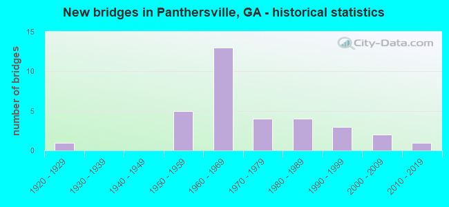
- New bridges - historical statistics
- 11920-1929
- 51950-1959
- 131960-1969
- 41970-1979
- 41980-1989
- 31990-1999
- 22000-2009
- 12010-2019

- Reconstructed bridges - Historical Statistics
- 71970-1979
- 01980-1989
- 21990-1999


- Bridge Condition - Deck
- 19.2%Very good
- 69.2%Good
- 11.5%Satisfactory

- Bridge Condition - Superstructure
- 38.5%Very good
- 57.7%Good
- 3.8%Satisfactory

- Bridge Condition - Substructure
- 7.7%Very good
- 73.1%Good
- 15.4%Satisfactory
- 3.8%Fair

- Bridge Condition - Channel
- 36.8%Very good
- 42.1%Good
- 10.5%Satisfactory
- 10.5%Fair

- Bridge Condition - Culverts
- 71.4%Good
- 14.3%Satisfactory
- 14.3%Fair
Find on map >> Show street view
Structure Number: 890041, Location: 6.5 MI SE OF DECATUR (Lat: 33.683725, Lng: -84.248811), Route carried "on" structure: State highway 155, Year Built: 1984, Status: Open, Structure Length: 6.10m (20.01ft), Average Daily Traffic: 33,500 (year 2011), Truck Traffic: 1%, Average Future Daily Traffic: 50,250 (year 2031), Design Load: HS 20+Mod, Features Intersected: COBBS CREEK, Facility Carried by Structure: FLAT SHOALS ROAD
Minimum Vertical Clearance: 30+ m (98+ ft), Kilometerpoint: 9.656, Lanes on structure: 5, Base Highway Network: Yes, Owner: State Highway Agency, Approaching Roadway Width: 20.1m (65.9ft), Skew: 4 degrees, Material/Design: Prestressed concrete, Design/Construction: Stringer/Multi-beam, Number Of Spans In Main Unit: 5, Length of Maximum Span: 12.2m (40.0ft), Curb or Sidewalk Widths: Left: 1.8m (5.9ft), Right: 1.8m (5.9ft), Curb-To-Curb Width: 20.1m (65.9ft), Out-to-Out Width: 25.6m (84.0ft)
Condition: Deck: Good, Superstructure: Very good, Substructure: Satisfactory, Channel: Fair, Operating Rating: 46.2 metric tons, Method Used To Determine Operating Rating: Allowable Stress (AS), Inventory Rating: 32.6 metric tons, Method Used To Determine Inventory Rating: Allowable Stress (AS), Structural Evaluation: Equal to present minimum criteria, Deck Geometry: Somewhat better than minimum adequacy, Waterway Adequacy: Equal to present desirable criteria, Approach Roadway Alignment: Equal to present desirable criteria, Designated Inspection Frequency: Every 24 months, Inspection Date: March 2020, Bridge Improvement Cost: $1,421,000, Roadway Improvement Cost: $142,000, Total Project Cost: $2,131,000, Deck Structure Type: Concrete Cast-file-Place
Find on map >> Show street view
Structure Number: 890055, Location: 3.5 MI S OF DECATUR (Lat: 33.714819, Lng: -84.297939), Route carried "on" structure: Interstate 20, Year Built: 1959, Year Reconstructed: 1995, Status: Open, Structure Length: 0.91m (2.99ft), Average Daily Traffic: 131,680 (year 2011), Truck Traffic: 1%, Average Future Daily Traffic: 197,520 (year 2031), Design Load: HS 20+Mod, Features Intersected: DOOLITTLE CREEK
Minimum Vertical Clearance: 30+ m (98+ ft), Kilometerpoint: 102.998, Lanes on structure: 10, Base Highway Network: Yes, Owner: State Highway Agency, Approaching Roadway Width: 51.2m (168.0ft), Skew: 39 degrees, Material/Design: Concrete, Design/Construction: Culvert, Number Of Spans In Main Unit: 2, Length of Maximum Span: 3.0m (9.8ft)
Condition: Channel: Good, Culverts: Satisfactory, Structural Evaluation: Equal to present minimum criteria, Waterway Adequacy: Equal to present desirable criteria, Approach Roadway Alignment: Equal to present desirable criteria, Designated Inspection Frequency: Every 24 months, Inspection Date: April 2020, Bridge Improvement Cost: $373,000, Roadway Improvement Cost: $37,000, Total Project Cost: $559,000
Find on map >> Show street view
Structure Number: 890056, Location: 7 MI SE OF DECATUR (Lat: 33.715039, Lng: -84.264319), Route carried "on" structure: Interstate 20, Year Built: 1959, Status: Open, Structure Length: 1.49m (4.89ft), Average Daily Traffic: 132,090 (year 2011), Truck Traffic: 1%, Average Future Daily Traffic: 198,135 (year 2031), Design Load: HS 20+Mod, Features Intersected: SHOAL CREEK
Minimum Vertical Clearance: 30+ m (98+ ft), Kilometerpoint: 106.217, Lanes on structure: 10, Base Highway Network: Yes, Owner: State Highway Agency, Approaching Roadway Width: 51.2m (168.0ft), Skew: 39 degrees, Material/Design: Concrete, Design/Construction: Culvert, Number Of Spans In Main Unit: 4, Length of Maximum Span: 3.4m (11.2ft)
Condition: Channel: Good, Culverts: Fair, Structural Evaluation: Somewhat better than minimum adequacy, Waterway Adequacy: Superior to present desirable criteria, Approach Roadway Alignment: Equal to present desirable criteria, Designated Inspection Frequency: Every 24 months, Inspection Date: April 2020, Bridge Improvement Cost: $609,000, Roadway Improvement Cost: $61,000, Total Project Cost: $914,000
Find on map >> Show street view
Structure Number: 890096, Location: 5.8 MI SE OF DECATUR (Lat: 33.714625, Lng: -84.240919), Route carried "on" structure: Interstate 285, Year Built: 1965, Year Reconstructed: 1984, Status: Open, Structure Length: 7.47m (24.51ft), Average Daily Traffic: 150,790 (year 2011), Truck Traffic: 1%, Average Future Daily Traffic: 226,185 (year 2031), Design Load: HS 20+Mod, Features Intersected: I-20
Minimum Vertical Clearance: 30+ m (98+ ft), Kilometerpoint: 74.030, Lanes on structure: 7, Lanes under structure: 7, Base Highway Network: Yes, Owner: State Highway Agency, Approaching Roadway Width: 34.1m (111.9ft), Skew: 33 degrees, Material/Design: Steel continuous, Design/Construction: Stringer/Multi-beam, Number Of Spans In Main Unit: 4, Length of Maximum Span: 25.0m (82.0ft), Curb-To-Curb Width: 40.0m (131.2ft), Out-to-Out Width: 41.9m (137.5ft)
Condition: Deck: Satisfactory, Superstructure: Good, Substructure: Satisfactory, Operating Rating: 55.3 metric tons, Method Used To Determine Operating Rating: Allowable Stress (AS), Inventory Rating: 32.6 metric tons, Method Used To Determine Inventory Rating: Allowable Stress (AS), Structural Evaluation: Equal to present minimum criteria, Deck Geometry: Superior to present desirable criteria, Underclear: Meets minimum limits, Approach Roadway Alignment: Equal to present desirable criteria, Designated Inspection Frequency: Every 24 months, Inspection Date: April 2020, Bridge Improvement Cost: $2,263,000, Roadway Improvement Cost: $226,000, Total Project Cost: $3,394,000, Deck Structure Type: Concrete Cast-file-Place
Find on map >> Show street view
Structure Number: 890097, Location: INTERSECTION I-20 & I-285 (Lat: 33.714911, Lng: -84.243164), Route carried "on" structure: Ramp Interstate 285, Year Built: 1965, Year Reconstructed: 2004, Status: Open, Structure Length: 7.13m (23.39ft), Average Daily Traffic: 48,800 (year 2011), Truck Traffic: 1%, Average Future Daily Traffic: 73,200 (year 2031), Design Load: HS 20+Mod, Features Intersected: I-20
Minimum Vertical Clearance: 30+ m (98+ ft), Kilometerpoint: 74.030, Lanes on structure: 3, Lanes under structure: 7, Base Highway Network: Yes, Owner: State Highway Agency, Approaching Roadway Width: 30.5m (100.1ft), Skew: 32 degrees, Material/Design: Steel continuous, Design/Construction: Stringer/Multi-beam, Number Of Spans In Main Unit: 4, Length of Maximum Span: 23.8m (78.1ft), Curb-To-Curb Width: 22.7m (74.5ft), Out-to-Out Width: 31.7m (104.0ft)
Condition: Deck: Good, Superstructure: Good, Substructure: Good, Operating Rating: 46.2 metric tons, Method Used To Determine Operating Rating: Load Factor (LF), Inventory Rating: 32.6 metric tons, Method Used To Determine Inventory Rating: Load Factor (LF), Structural Evaluation: Better than present minimum criteria, Deck Geometry: Superior to present desirable criteria, Underclear: High priority of corrective action, Approach Roadway Alignment: Equal to present desirable criteria, Length Of Structure Improvement: 13.66m (44.82ft), Designated Inspection Frequency: Every 24 months, Inspection Date: April 2020, Bridge Improvement Cost: $1,164,000, Roadway Improvement Cost: $116,000, Total Project Cost: $1,745,000, Deck Structure Type: Concrete Cast-file-Place, Wearing Surface/Protective System: Wearing Surface: Epoxy Overlay
Find on map >> Show street view
Structure Number: 890098, Location: 8.5 MI SE OF DECATUR (Lat: 33.698983, Lng: -84.257944), Route carried "on" structure: Interstate 285, Year Built: 1966, Year Reconstructed: 1979, Status: Open, Structure Length: 6.16m (20.21ft), Average Daily Traffic: 150,790 (year 2011), Truck Traffic: 1%, Average Future Daily Traffic: 226,185 (year 2031), Design Load: HS 20+Mod, Features Intersected: SHOAL CREEK
Minimum Vertical Clearance: 30+ m (98+ ft), Kilometerpoint: 77.249, Lanes on structure: 8, Base Highway Network: Yes, Owner: State Highway Agency, Approaching Roadway Width: 39.0m (128.0ft), Skew: 33 degrees, Material/Design: Steel, Design/Construction: Stringer/Multi-beam, Number Of Spans In Main Unit: 3, Length of Maximum Span: 20.7m (67.9ft), Curb-To-Curb Width: 39.2m (128.6ft), Out-to-Out Width: 40.9m (134.2ft)
Condition: Deck: Good, Superstructure: Good, Substructure: Good, Channel: Satisfactory, Operating Rating: 38.1 metric tons, Method Used To Determine Operating Rating: Load Factor (LF), Inventory Rating: 22.6 metric tons, Method Used To Determine Inventory Rating: Load Factor (LF), Structural Evaluation: Somewhat better than minimum adequacy, Deck Geometry: Superior to present desirable criteria, Waterway Adequacy: Superior to present desirable criteria, Approach Roadway Alignment: Equal to present desirable criteria, Designated Inspection Frequency: Every 24 months, Inspection Date: April 2020, Bridge Improvement Cost: $2,081,000, Roadway Improvement Cost: $208,000, Total Project Cost: $3,121,000, Deck Structure Type: Concrete Cast-file-Place, Wearing Surface/Protective System: Wearing Surface: Bituminous, Membrane: Built-up
Find on map >> Show street view
Structure Number: 890099, Location: 8 MI S OF DECATUR (Lat: 33.696197, Lng: -84.285728), Route carried "on" structure: Interstate 285, Year Built: 1967, Year Reconstructed: 1979, Status: Open, Structure Length: 5.24m (17.19ft), Average Daily Traffic: 145,890 (year 2011), Truck Traffic: 1%, Average Future Daily Traffic: 218,835 (year 2031), Design Load: HS 20+Mod, Features Intersected: DOOLITTLE CREEK
Minimum Vertical Clearance: 30+ m (98+ ft), Kilometerpoint: 78.858, Lanes on structure: 8, Base Highway Network: Yes, Owner: State Highway Agency, Approaching Roadway Width: 39.0m (128.0ft), Skew: 33 degrees, Material/Design: Concrete, Design/Construction: Tee Beam, Number Of Spans In Main Unit: 5, Length of Maximum Span: 11.0m (36.1ft), Curb-To-Curb Width: 39.2m (128.6ft), Out-to-Out Width: 40.9m (134.2ft)
Condition: Deck: Good, Superstructure: Good, Substructure: Good, Channel: Satisfactory, Operating Rating: 41.7 metric tons, Method Used To Determine Operating Rating: Load Factor (LF), Inventory Rating: 25.4 metric tons, Method Used To Determine Inventory Rating: Load Factor (LF), Structural Evaluation: Equal to present minimum criteria, Deck Geometry: Superior to present desirable criteria, Waterway Adequacy: Equal to present desirable criteria, Approach Roadway Alignment: Equal to present desirable criteria, Designated Inspection Frequency: Every 24 months, Inspection Date: April 2020, Bridge Improvement Cost: $1,772,000, Roadway Improvement Cost: $177,000, Total Project Cost: $2,658,000, Deck Structure Type: Concrete Cast-file-Place, Wearing Surface/Protective System: Wearing Surface: Bituminous, Membrane: Built-up
Find on map >> Show street view
Structure Number: 8901, Location: 8 MI S OF DECATUR (Lat: 33.690328, Lng: -84.299989), Route carried "on" structure: Interstate 285, Year Built: 1966, Year Reconstructed: 1979, Status: Open, Structure Length: 3.47m (11.38ft), Average Daily Traffic: 145,890 (year 2011), Truck Traffic: 1%, Average Future Daily Traffic: 218,835 (year 2031), Design Load: HS 20+Mod, Features Intersected: SUGAR CREEK
Minimum Vertical Clearance: 30+ m (98+ ft), Kilometerpoint: 80.467, Lanes on structure: 8, Base Highway Network: Yes, Owner: State Highway Agency, Approaching Roadway Width: 39.0m (128.0ft), Skew: 30 degrees, Material/Design: Concrete, Design/Construction: Tee Beam, Number Of Spans In Main Unit: 3, Length of Maximum Span: 11.6m (38.1ft), Curb-To-Curb Width: 39.2m (128.6ft), Out-to-Out Width: 40.9m (134.2ft)
Condition: Deck: Good, Superstructure: Good, Substructure: Good, Channel: Good, Operating Rating: 39.9 metric tons, Method Used To Determine Operating Rating: Load Factor (LF), Inventory Rating: 23.5 metric tons, Method Used To Determine Inventory Rating: Load Factor (LF), Structural Evaluation: Somewhat better than minimum adequacy, Deck Geometry: Superior to present desirable criteria, Waterway Adequacy: Equal to present desirable criteria, Approach Roadway Alignment: Equal to present desirable criteria, Designated Inspection Frequency: Every 24 months, Inspection Date: March 2020, Bridge Improvement Cost: $1,174,000, Roadway Improvement Cost: $117,000, Total Project Cost: $1,761,000, Deck Structure Type: Concrete Cast-file-Place, Wearing Surface/Protective System: Wearing Surface: Bituminous, Membrane: Built-up
Find on map >> Show street view
Structure Number: 890101, Location: 8 MI S OF DECATUR (Lat: 33.689808, Lng: -84.301358), Route carried "on" structure: Interstate 285, Year Built: 1966, Year Reconstructed: 1979, Status: Open, Structure Length: 3.47m (11.38ft), Average Daily Traffic: 145,890 (year 2011), Truck Traffic: 1%, Average Future Daily Traffic: 218,835 (year 2031), Design Load: HS 20+Mod, Features Intersected: SUGAR CREEK OVERFLOW
Minimum Vertical Clearance: 30+ m (98+ ft), Kilometerpoint: 80.467, Lanes on structure: 8, Base Highway Network: Yes, Owner: State Highway Agency, Approaching Roadway Width: 39.0m (128.0ft), Skew: 31 degrees, Material/Design: Concrete, Design/Construction: Tee Beam, Number Of Spans In Main Unit: 3, Length of Maximum Span: 11.6m (38.1ft), Curb-To-Curb Width: 39.2m (128.6ft), Out-to-Out Width: 40.9m (134.2ft)
Condition: Deck: Good, Superstructure: Good, Substructure: Good, Operating Rating: 36.2 metric tons, Method Used To Determine Operating Rating: Load Factor (LF), Inventory Rating: 21.7 metric tons, Method Used To Determine Inventory Rating: Load Factor (LF), Structural Evaluation: Somewhat better than minimum adequacy, Deck Geometry: Superior to present desirable criteria, Approach Roadway Alignment: Equal to present desirable criteria, Designated Inspection Frequency: Every 24 months, Inspection Date: March 2020, Bridge Improvement Cost: $1,174,000, Roadway Improvement Cost: $117,000, Total Project Cost: $1,761,000, Deck Structure Type: Concrete Cast-file-Place, Wearing Surface/Protective System: Wearing Surface: Bituminous, Membrane: Built-up
Find on map >> Show street view
Structure Number: 89012, Location: 7.5 MI S OF DECATUR (Lat: 33.656453, Lng: -84.286244), Route carried "on" structure: City street 9394, Year Built: 1958, Status: Open, Structure Length: 1.89m (6.20ft), Average Daily Traffic: 6,080 (year 2011), Truck Traffic: 1%, Average Future Daily Traffic: 9,120 (year 2031), Design Load: H 15, Features Intersected: CONLEY CREEK, Facility Carried by Structure: BOULDERCREST RD
Minimum Vertical Clearance: 30+ m (98+ ft), Kilometerpoint: 3.219, Lanes on structure: 2, Base Highway Network: Yes, Owner: County Highway Agency, Approaching Roadway Width: 6.1m (20.0ft), Skew: 3 degrees, Material/Design: Concrete, Design/Construction: Culvert, Number Of Spans In Main Unit: 4, Length of Maximum Span: 3.7m (12.1ft)
Condition: Channel: Very good, Culverts: Good, Operating Rating: 43.5 metric tons, Method Used To Determine Operating Rating: Field evaluation and documented engineering judgment, Inventory Rating: 24.4 metric tons, Method Used To Determine Inventory Rating: Field evaluation and documented engineering judgment, Structural Evaluation: Equal to present minimum criteria, Waterway Adequacy: Superior to present desirable criteria, Approach Roadway Alignment: Equal to present desirable criteria, Designated Inspection Frequency: Every 24 months, Inspection Date: March 2020, Bridge Improvement Cost: $242,000, Roadway Improvement Cost: $24,000, Total Project Cost: $363,000
Find on map >> Show street view
Structure Number: 890145, Location: 6 MI SE OF DECATUR (Lat: 33.684528, Lng: -84.272608), Route carried "on" structure: City street 9091, Year Built: 1962, Status: Open, Structure Length: 4.39m (14.40ft), Average Daily Traffic: 19,230 (year 2011), Truck Traffic: 5%, Average Future Daily Traffic: 28,845 (year 2031), Design Load: H 15, Features Intersected: SOUTH RIVER, Facility Carried by Structure: PANTHERVILLE ROAD
Minimum Vertical Clearance: 30+ m (98+ ft), Kilometerpoint: 8.047, Lanes on structure: 2, Base Highway Network: Yes, Owner: County Highway Agency, Approaching Roadway Width: 8.5m (27.9ft), Skew: 1 degrees, Material/Design: Concrete, Design/Construction: Tee Beam, Number Of Spans In Main Unit: 4, Length of Maximum Span: 11.0m (36.1ft), Curb or Sidewalk Widths: Left: 0.6m (2.0ft), Right: 0.6m (2.0ft), Curb-To-Curb Width: 8.5m (27.9ft), Out-to-Out Width: 10.4m (34.1ft)
Condition: Deck: Satisfactory, Superstructure: Good, Substructure: Good, Channel: Good, Operating Rating: 37.1 metric tons, Method Used To Determine Operating Rating: Allowable Stress (AS), Inventory Rating: 21.7 metric tons, Method Used To Determine Inventory Rating: Allowable Stress (AS), Structural Evaluation: Somewhat better than minimum adequacy, Deck Geometry: High priority of replacement, Waterway Adequacy: Equal to present desirable criteria, Approach Roadway Alignment: Equal to present desirable criteria, Length Of Structure Improvement: 10.82m (35.50ft), Designated Inspection Frequency: Every 24 months, Inspection Date: March 2020, Bridge Improvement Cost: $563,000, Roadway Improvement Cost: $56,000, Total Project Cost: $844,000, Deck Structure Type: Concrete Cast-file-Place
Find on map >> Show street view
Structure Number: 890146, Location: 7.5 MI SE OF DECATUR (Lat: 33.699008, Lng: -84.270869), Route carried "on" structure: City street 9091, Year Built: 1967, Year Reconstructed: 1984, Status: Open, Structure Length: 7.68m (25.20ft), Average Daily Traffic: 19,230 (year 2011), Truck Traffic: 5%, Average Future Daily Traffic: 28,845 (year 2031), Design Load: HS 20+Mod, Features Intersected: I-285 (SR 407), Facility Carried by Structure: PANTHERSVILLE RD
Minimum Vertical Clearance: 30+ m (98+ ft), Kilometerpoint: 9.656, Lanes on structure: 4, Lanes under structure: 9, Base Highway Network: Yes, Owner: State Highway Agency, Approaching Roadway Width: 14.6m (47.9ft), Skew: 1 degrees, Material/Design: Steel continuous, Design/Construction: Stringer/Multi-beam, Number Of Spans In Main Unit: 4, Length of Maximum Span: 25.0m (82.0ft), Curb or Sidewalk Widths: Left: 1.8m (5.9ft), Right: 1.8m (5.9ft), Curb-To-Curb Width: 15.8m (51.8ft), Out-to-Out Width: 20.2m (66.3ft)
Condition: Deck: Good, Superstructure: Good, Substructure: Good, Operating Rating: 46.2 metric tons, Method Used To Determine Operating Rating: Allowable Stress (AS), Inventory Rating: 32.6 metric tons, Method Used To Determine Inventory Rating: Allowable Stress (AS), Structural Evaluation: Better than present minimum criteria, Deck Geometry: Meets minimum limits, Underclear: Equal to present minimum criteria, Approach Roadway Alignment: Equal to present desirable criteria, Designated Inspection Frequency: Every 24 months, Inspection Date: April 2020, Bridge Improvement Cost: $1,522,000, Roadway Improvement Cost: $152,000, Total Project Cost: $2,283,000, Deck Structure Type: Concrete Cast-file-Place, Wearing Surface/Protective System: Wearing Surface: Bituminous, Membrane: Built-up
Find on map >> Show street view
Structure Number: 890152, Location: 8.5 MI S OF DECATUR (Lat: 33.692964, Lng: -84.293572), Route carried "on" structure: City street 9121, Year Built: 1967, Status: Open, Structure Length: 7.68m (25.20ft), Average Daily Traffic: 8,910 (year 2011), Truck Traffic: 1%, Average Future Daily Traffic: 13,365 (year 2031), Design Load: HS 20+Mod, Features Intersected: I-285 (SR 407), Facility Carried by Structure: CLIFTON SPRING RD
Minimum Vertical Clearance: 30+ m (98+ ft), Kilometerpoint: 1.609, Lanes on structure: 2, Lanes under structure: 8, Base Highway Network: Yes, Owner: State Highway Agency, Approaching Roadway Width: 7.3m (24.0ft), Material/Design: Steel continuous, Design/Construction: Stringer/Multi-beam, Number Of Spans In Main Unit: 4, Length of Maximum Span: 22.9m (75.1ft), Curb or Sidewalk Widths: Left: 1.2m (3.9ft), Right: 0.6m (2.0ft), Curb-To-Curb Width: 7.9m (25.9ft), Out-to-Out Width: 10.7m (35.1ft)
Condition: Deck: Good, Superstructure: Good, Substructure: Good, Operating Rating: 46.2 metric tons, Method Used To Determine Operating Rating: Allowable Stress (AS), Inventory Rating: 32.6 metric tons, Method Used To Determine Inventory Rating: Allowable Stress (AS), Structural Evaluation: Better than present minimum criteria, Deck Geometry: High priority of corrective action, Underclear: Somewhat better than minimum adequacy, Approach Roadway Alignment: Equal to present desirable criteria, Length Of Structure Improvement: 14.17m (46.49ft), Designated Inspection Frequency: Every 24 months, Inspection Date: April 2020, Bridge Improvement Cost: $985,000, Roadway Improvement Cost: $98,000, Total Project Cost: $1,477,000, Deck Structure Type: Concrete Cast-file-Place
Find on map >> Show street view
Structure Number: 890153, Location: 5.5 MI S OF DECATUR (Lat: 33.690439, Lng: -84.278639), Route carried "on" structure: County highway 9121, Year Built: 1970, Status: Open, Structure Length: 0.98m (3.22ft), Average Daily Traffic: 11,080 (year 2011), Truck Traffic: 1%, Average Future Daily Traffic: 16,620 (year 2031), Design Load: HS 20+Mod, Features Intersected: DOOLITTLE CREEK, Facility Carried by Structure: CLIFTON SPRINGS RD
Minimum Vertical Clearance: 30+ m (98+ ft), Kilometerpoint: 3.219, Lanes on structure: 3, Base Highway Network: Yes, Owner: County Highway Agency, Approaching Roadway Width: 9.4m (30.8ft), Material/Design: Concrete, Design/Construction: Culvert, Number Of Spans In Main Unit: 3, Length of Maximum Span: 3.0m (9.8ft), Curb or Sidewalk Widths: Left: 0.0m, Right: 1.5m (4.9ft)
Condition: Channel: Very good, Culverts: Good, Operating Rating: 55.3 metric tons, Method Used To Determine Operating Rating: Field evaluation and documented engineering judgment, Inventory Rating: 32.6 metric tons, Method Used To Determine Inventory Rating: Field evaluation and documented engineering judgment, Structural Evaluation: Better than present minimum criteria, Waterway Adequacy: Superior to present desirable criteria, Approach Roadway Alignment: Equal to present desirable criteria, Designated Inspection Frequency: Every 24 months, Inspection Date: March 2020, Bridge Improvement Cost: $159,000, Roadway Improvement Cost: $16,000, Total Project Cost: $239,000
Find on map >> Show street view
Structure Number: 890154, Location: 8.5 MI SE OF DECATUR (Lat: 33.701739, Lng: -84.252169), Route carried "on" structure: County highway 9121, Year Built: 1967, Status: Open, Structure Length: 9.14m (29.99ft), Average Daily Traffic: 10,670 (year 2011), Truck Traffic: 4%, Average Future Daily Traffic: 16,005 (year 2031), Design Load: HS 20+Mod, Features Intersected: I-285 (SR 407), Facility Carried by Structure: COLUMBIA DRIVE
Minimum Vertical Clearance: 30+ m (98+ ft), Kilometerpoint: 6.437, Lanes on structure: 2, Lanes under structure: 8, Base Highway Network: Yes, Owner: State Highway Agency, Approaching Roadway Width: 7.3m (24.0ft), Skew: 3 degrees, Material/Design: Steel continuous, Design/Construction: Stringer/Multi-beam, Number Of Spans In Main Unit: 4, Length of Maximum Span: 25.3m (83.0ft), Curb or Sidewalk Widths: Left: 1.2m (3.9ft), Right: 1.5m (4.9ft), Curb-To-Curb Width: 7.0m (23.0ft), Out-to-Out Width: 10.5m (34.4ft)
Condition: Deck: Good, Superstructure: Good, Substructure: Good, Operating Rating: 39.9 metric tons, Method Used To Determine Operating Rating: Load Factor (LF), Inventory Rating: 23.5 metric tons, Method Used To Determine Inventory Rating: Load Factor (LF), Structural Evaluation: Somewhat better than minimum adequacy, Deck Geometry: High priority of replacement, Underclear: Meets minimum limits, Approach Roadway Alignment: Equal to present minimum criteria, Length Of Structure Improvement: 49.38m (162.01ft), Designated Inspection Frequency: Every 24 months, Inspection Date: March 2020, Bridge Improvement Cost: $1,172,000, Roadway Improvement Cost: $117,000, Total Project Cost: $1,758,000, Deck Structure Type: Concrete Cast-file-Place
Find on map >> Show street view
Structure Number: 89016, Location: 4.5 MI SE OF DECATUR (Lat: 33.709728, Lng: -84.265908), Route carried "on" structure: County highway 9122, Year Built: 1925, Status: Open, Structure Length: 1.13m (3.71ft), Average Daily Traffic: 8,740 (year 2011), Truck Traffic: 3%, Average Future Daily Traffic: 13,110 (year 2031), Design Load: H 15, Features Intersected: SHOAL CREEK, Facility Carried by Structure: RAINBOW DRIVE
Minimum Vertical Clearance: 30+ m (98+ ft), Kilometerpoint: 8.047, Lanes on structure: 2, Base Highway Network: Yes, Owner: County Highway Agency, Approaching Roadway Width: 7.3m (24.0ft), Skew: 2 degrees, Material/Design: Concrete, Design/Construction: Culvert, Number Of Spans In Main Unit: 3, Length of Maximum Span: 3.7m (12.1ft)
Condition: Channel: Good, Culverts: Good, Structural Evaluation: Better than present minimum criteria, Waterway Adequacy: Superior to present desirable criteria, Approach Roadway Alignment: Equal to present desirable criteria, Designated Inspection Frequency: Every 24 months, Inspection Date: March 2020, Bridge Improvement Cost: $145,000, Roadway Improvement Cost: $14,000, Total Project Cost: $217,000
Find on map >> Show street view
Structure Number: 890161, Location: 8.2 MI SE OF DECATUR (Lat: 33.709539, Lng: -84.246269), Route carried "on" structure: County highway 9122, Year Built: 1967, Year Reconstructed: 1982, Status: Open, Structure Length: 10.21m (33.50ft), Average Daily Traffic: 14,520 (year 2011), Truck Traffic: 1%, Average Future Daily Traffic: 21,780 (year 2031), Design Load: HS 20+Mod, Features Intersected: I-285- I-20 RAMP, Facility Carried by Structure: RAINBOW DRIVE
Minimum Vertical Clearance: 30+ m (98+ ft), Kilometerpoint: 9.656, Lanes on structure: 2, Lanes under structure: 8, Base Highway Network: Yes, Owner: State Highway Agency, Approaching Roadway Width: 8.2m (26.9ft), Skew: 1 degrees, Material/Design: Steel, Design/Construction: Stringer/Multi-beam, Number Of Spans In Main Unit: 5, Length of Maximum Span: 27.4m (89.9ft), Curb or Sidewalk Widths: Left: 1.8m (5.9ft), Right: 1.5m (4.9ft), Curb-To-Curb Width: 8.5m (27.9ft), Out-to-Out Width: 12.7m (41.7ft)
Condition: Deck: Good, Superstructure: Good, Substructure: Good, Operating Rating: 29.0 metric tons, Method Used To Determine Operating Rating: Load Factor (LF), Inventory Rating: 17.2 metric tons, Method Used To Determine Inventory Rating: Load Factor (LF), Structural Evaluation: Meets minimum limits, Deck Geometry: Meets minimum limits, Underclear: High priority of corrective action, Approach Roadway Alignment: Better than present minimum criteria, Length Of Structure Improvement: 16.64m (54.59ft), Designated Inspection Frequency: Every 24 months, Inspection Date: April 2020, Bridge Improvement Cost: $1,309,000, Roadway Improvement Cost: $131,000, Total Project Cost: $1,963,000, Deck Structure Type: Concrete Cast-file-Place
Find on map >> Show street view
Structure Number: 890162, Location: 5.4 MI SE OF DECATUR (Lat: 33.709536, Lng: -84.239475), Route carried "on" structure: County highway 9122, Year Built: 1973, Status: Open, Structure Length: 1.58m (5.18ft), Average Daily Traffic: 14,520 (year 2011), Truck Traffic: 1%, Average Future Daily Traffic: 21,780 (year 2031), Design Load: H 20, Features Intersected: COBB CREEK, Facility Carried by Structure: RAINBOW DRIVE
Minimum Vertical Clearance: 30+ m (98+ ft), Kilometerpoint: 9.656, Lanes on structure: 2, Base Highway Network: Yes, Owner: County Highway Agency, Approaching Roadway Width: 7.6m (24.9ft), Material/Design: Steel, Design/Construction: Stringer/Multi-beam, Number Of Spans In Main Unit: 2, Length of Maximum Span: 7.9m (25.9ft), Curb or Sidewalk Widths: Left: 1.6m (5.2ft), Right: 1.0m (3.3ft), Curb-To-Curb Width: 8.5m (27.9ft), Out-to-Out Width: 11.8m (38.7ft)
Condition: Deck: Very good, Superstructure: Satisfactory, Substructure: Satisfactory, Channel: Very good, Operating Rating: 48.9 metric tons, Method Used To Determine Operating Rating: Load Factor (LF), Inventory Rating: 29.0 metric tons, Method Used To Determine Inventory Rating: Load Factor (LF), Structural Evaluation: Equal to present minimum criteria, Deck Geometry: High priority of replacement, Waterway Adequacy: Superior to present desirable criteria, Approach Roadway Alignment: Equal to present minimum criteria, Length Of Structure Improvement: 41.79m (137.11ft), Designated Inspection Frequency: Every 24 months, Inspection Date: March 2020, Bridge Improvement Cost: $203,000, Roadway Improvement Cost: $20,000, Total Project Cost: $305,000, Deck Structure Type: Concrete Cast-file-Place, Wearing Surface/Protective System: Wearing Surface: Bituminous
Find on map >> Show street view
Structure Number: 890248, Location: 5.8 MI SE OF DECATUR (Lat: 33.693164, Lng: -84.253775), Route carried "on" structure: County highway 9121, Year Built: 1977, Status: Open, Structure Length: 4.88m (16.01ft), Average Daily Traffic: 10,670 (year 2011), Truck Traffic: 4%, Average Future Daily Traffic: 16,005 (year 2031), Design Load: HS 20, Features Intersected: SHOAL CREEK, Facility Carried by Structure: COLUMBIA DRIVE
Minimum Vertical Clearance: 30+ m (98+ ft), Kilometerpoint: 4.828, Lanes on structure: 2, Base Highway Network: Yes, Owner: County Highway Agency, Approaching Roadway Width: 8.2m (26.9ft), Material/Design: Concrete, Design/Construction: Tee Beam, Number Of Spans In Main Unit: 4, Length of Maximum Span: 12.2m (40.0ft), Curb or Sidewalk Widths: Left: 1.8m (5.9ft), Right: 0.0m, Curb-To-Curb Width: 12.5m (41.0ft), Out-to-Out Width: 18.3m (60.0ft)
Condition: Deck: Good, Superstructure: Good, Substructure: Good, Channel: Fair, Operating Rating: 46.2 metric tons, Method Used To Determine Operating Rating: Allowable Stress (AS), Inventory Rating: 32.6 metric tons, Method Used To Determine Inventory Rating: Allowable Stress (AS), Structural Evaluation: Better than present minimum criteria, Deck Geometry: Somewhat better than minimum adequacy, Waterway Adequacy: Superior to present desirable criteria, Approach Roadway Alignment: Equal to present desirable criteria, Designated Inspection Frequency: Every 24 months, Inspection Date: March 2020, Bridge Improvement Cost: $625,000, Roadway Improvement Cost: $63,000, Total Project Cost: $938,000, Deck Structure Type: Concrete Cast-file-Place
Find on map >> Show street view
Structure Number: 890258, Location: 5.8 MI SE OF DECATUR (Lat: 33.713561, Lng: -84.242244), Route carried "on" structure: Interstate 285, Year Built: 1983, Status: Open, Structure Length: 2.56m (8.40ft), Average Daily Traffic: 150,790 (year 2011), Truck Traffic: 1%, Average Future Daily Traffic: 226,185 (year 2031), Design Load: HS 20+Mod, Features Intersected: I-20 RAMP
Minimum Vertical Clearance: 30+ m (98+ ft), Kilometerpoint: 74.030, Lanes on structure: 6, Lanes under structure: 2, Base Highway Network: Yes, Owner: State Highway Agency, Approaching Roadway Width: 34.1m (111.9ft), Skew: 32 degrees, Material/Design: Prestressed concrete, Design/Construction: Stringer/Multi-beam, Number Of Spans In Main Unit: 1, Length of Maximum Span: 25.6m (84.0ft), Curb-To-Curb Width: 34.1m (111.9ft), Out-to-Out Width: 37.1m (121.7ft)
Condition: Deck: Good, Superstructure: Very good, Substructure: Good, Operating Rating: 68.9 metric tons, Method Used To Determine Operating Rating: Load Factor (LF), Inventory Rating: 35.3 metric tons, Method Used To Determine Inventory Rating: Load Factor (LF), Structural Evaluation: Better than present minimum criteria, Deck Geometry: Superior to present desirable criteria, Underclear: Equal to present minimum criteria, Approach Roadway Alignment: Equal to present desirable criteria, Designated Inspection Frequency: Every 24 months, Inspection Date: April 2020, Bridge Improvement Cost: $686,000, Roadway Improvement Cost: $69,000, Total Project Cost: $1,029,000, Deck Structure Type: Concrete Cast-file-Place, Wearing Surface/Protective System: Deck Protection: Epoxy Coated Reinforcing
Find on map >> Show street view
Structure Number: 890259, Location: I-285 & I-20 INT. (Lat: 33.714089, Lng: -84.243875), Route carried "on" structure: Ramp Interstate 285, Year Built: 1985, Status: Open, Structure Length: 2.32m (7.61ft), Average Daily Traffic: 22,560 (year 2011), Truck Traffic: 1%, Average Future Daily Traffic: 33,840 (year 2031), Design Load: HS 20+Mod, Features Intersected: I-20 RAMP
Minimum Vertical Clearance: 30+ m (98+ ft), Kilometerpoint: 74.030, Lanes on structure: 3, Lanes under structure: 2, Base Highway Network: Yes, Owner: State Highway Agency, Approaching Roadway Width: 12.5m (41.0ft), Material/Design: Prestressed concrete, Design/Construction: Stringer/Multi-beam, Number Of Spans In Main Unit: 1, Length of Maximum Span: 23.2m (76.1ft), Curb-To-Curb Width: 12.9m (42.3ft), Out-to-Out Width: 28.5m (93.5ft)
Condition: Deck: Good, Superstructure: Very good, Substructure: Good, Operating Rating: 64.4 metric tons, Method Used To Determine Operating Rating: Load Factor (LF), Inventory Rating: 34.4 metric tons, Method Used To Determine Inventory Rating: Load Factor (LF), Structural Evaluation: Better than present minimum criteria, Deck Geometry: Somewhat better than minimum adequacy, Underclear: Superior to present desirable criteria, Approach Roadway Alignment: Equal to present desirable criteria, Designated Inspection Frequency: Every 24 months, Inspection Date: March 2020, Bridge Improvement Cost: $378,000, Roadway Improvement Cost: $38,000, Total Project Cost: $567,000, Deck Structure Type: Concrete Cast-file-Place, Wearing Surface/Protective System: Deck Protection: Epoxy Coated Reinforcing
Find on map >> Show street view
Structure Number: 89026, Location: 5.8 MI SE OF DECATUR (Lat: 33.712814, Lng: -84.243164), Route carried "on" structure: Ramp Interstate 285, Year Built: 1982, Status: Open, Structure Length: 8.05m (26.41ft), Average Daily Traffic: 48,800 (year 2011), Truck Traffic: 1%, Average Future Daily Traffic: 73,200 (year 2031), Design Load: HS 20+Mod, Features Intersected: I-285 (SR 407)
Minimum Vertical Clearance: 30+ m (98+ ft), Kilometerpoint: 74.030, Lanes on structure: 2, Lanes under structure: 6, Base Highway Network: Yes, Owner: State Highway Agency, Approaching Roadway Width: 12.2m (40.0ft), Material/Design: Steel continuous, Design/Construction: Stringer/Multi-beam, Number Of Spans In Main Unit: 4, Length of Maximum Span: 25.3m (83.0ft), Curb-To-Curb Width: 12.2m (40.0ft), Out-to-Out Width: 13.2m (43.3ft)
Condition: Deck: Good, Superstructure: Very good, Substructure: Good, Operating Rating: 84.3 metric tons, Method Used To Determine Operating Rating: Load Factor (LF), Inventory Rating: 50.8 metric tons, Method Used To Determine Inventory Rating: Load Factor (LF), Structural Evaluation: Better than present minimum criteria, Deck Geometry: Superior to present desirable criteria, Underclear: Better than present minimum criteria, Approach Roadway Alignment: Equal to present desirable criteria, Designated Inspection Frequency: Every 24 months, Inspection Date: March 2020, Bridge Improvement Cost: $1,032,000, Roadway Improvement Cost: $103,000, Total Project Cost: $1,547,000, Deck Structure Type: Concrete Cast-file-Place, Wearing Surface/Protective System: Wearing Surface: Epoxy Overlay, Deck Protection: Epoxy Coated Reinforcing
Find on map >> Show street view
Structure Number: 890309, Location: 1.5 MI S OF DECATUR (Lat: 33.713581, Lng: -84.272272), Route carried "on" structure: State highway 155, Year Built: 1992, Status: Open, Structure Length: 5.76m (18.90ft), Average Daily Traffic: 23,540 (year 2011), Truck Traffic: 3%, Average Future Daily Traffic: 35,310 (year 2031), Design Load: HS 20+Mod, Features Intersected: I-20, Facility Carried by Structure: CANDLER ROAD
Minimum Vertical Clearance: 30+ m (98+ ft), Kilometerpoint: 14.484, Lanes on structure: 7, Lanes under structure: 10, Base Highway Network: Yes, Owner: State Highway Agency, Approaching Roadway Width: 18.3m (60.0ft), Skew: 1 degrees, Material/Design: Prestressed concrete, Design/Construction: Stringer/Multi-beam, Number Of Spans In Main Unit: 2, Length of Maximum Span: 29.0m (95.1ft), Curb or Sidewalk Widths: Left: 1.8m (5.9ft), Right: 1.8m (5.9ft), Curb-To-Curb Width: 26.8m (87.9ft), Out-to-Out Width: 31.2m (102.4ft)
Condition: Deck: Good, Superstructure: Very good, Substructure: Good, Operating Rating: 42.6 metric tons, Method Used To Determine Operating Rating: Load Factor (LF), Inventory Rating: 25.4 metric tons, Method Used To Determine Inventory Rating: Load Factor (LF), Structural Evaluation: Equal to present minimum criteria, Deck Geometry: Somewhat better than minimum adequacy, Underclear: Somewhat better than minimum adequacy, Approach Roadway Alignment: Equal to present desirable criteria, Designated Inspection Frequency: Every 24 months, Inspection Date: March 2020, Bridge Improvement Cost: $1,745,000, Roadway Improvement Cost: $175,000, Total Project Cost: $2,618,000, Deck Structure Type: Concrete Cast-file-Place
Find on map >> Show street view
Structure Number: 890313, Location: 7 MI SE OF DECATUR (Lat: 33.716147, Lng: -84.252378), Route carried "on" structure: City street 9121, Year Built: 1992, Status: Open, Structure Length: 5.67m (18.60ft), Average Daily Traffic: 20,870 (year 2011), Truck Traffic: 1%, Average Future Daily Traffic: 31,305 (year 2031), Design Load: HS 20+Mod, Features Intersected: I-20, Facility Carried by Structure: COLUMBIA DRIVE
Minimum Vertical Clearance: 30+ m (98+ ft), Kilometerpoint: 8.047, Lanes on structure: 5, Lanes under structure: 10, Base Highway Network: Yes, Owner: State Highway Agency, Approaching Roadway Width: 19.5m (64.0ft), Skew: 1 degrees, Material/Design: Prestressed concrete, Design/Construction: Stringer/Multi-beam, Number Of Spans In Main Unit: 2, Length of Maximum Span: 28.3m (92.8ft), Curb or Sidewalk Widths: Left: 1.8m (5.9ft), Right: 1.8m (5.9ft), Curb-To-Curb Width: 19.5m (64.0ft), Out-to-Out Width: 23.9m (78.4ft)
Condition: Deck: Good, Superstructure: Very good, Substructure: Good, Operating Rating: 44.4 metric tons, Method Used To Determine Operating Rating: Load Factor (LF), Inventory Rating: 26.3 metric tons, Method Used To Determine Inventory Rating: Load Factor (LF), Structural Evaluation: Equal to present minimum criteria, Deck Geometry: Meets minimum limits, Underclear: Meets minimum limits, Approach Roadway Alignment: Equal to present desirable criteria, Designated Inspection Frequency: Every 24 months, Inspection Date: May 2020, Bridge Improvement Cost: $1,321,000, Roadway Improvement Cost: $132,000, Total Project Cost: $1,982,000, Deck Structure Type: Concrete Cast-file-Place
Find on map >> Show street view
Structure Number: 890319, Location: 3 MI S OF DECATUR (Lat: 33.712258, Lng: -84.285719), Route carried "on" structure: County highway 168, Year Built: 1992, Status: Open, Structure Length: 6.10m (20.01ft), Average Daily Traffic: 2,202 (year 2011), Truck Traffic: 1%, Average Future Daily Traffic: 3,303 (year 2031), Design Load: HS 20+Mod, Features Intersected: I-20, Facility Carried by Structure: LLOYD ROAD
Minimum Vertical Clearance: 30+ m (98+ ft), Kilometerpoint: 3.219, Lanes on structure: 2, Lanes under structure: 10, Base Highway Network: Yes, Owner: State Highway Agency, Approaching Roadway Width: 8.5m (27.9ft), Skew: 1 degrees, Material/Design: Prestressed concrete, Design/Construction: Stringer/Multi-beam, Number Of Spans In Main Unit: 2, Length of Maximum Span: 30.5m (100.1ft), Curb or Sidewalk Widths: Left: 1.8m (5.9ft), Right: 1.8m (5.9ft), Curb-To-Curb Width: 8.5m (27.9ft), Out-to-Out Width: 12.9m (42.3ft)
Condition: Deck: Good, Superstructure: Very good, Substructure: Good, Operating Rating: 46.2 metric tons, Method Used To Determine Operating Rating: Allowable Stress (AS), Inventory Rating: 32.6 metric tons, Method Used To Determine Inventory Rating: Allowable Stress (AS), Structural Evaluation: Better than present minimum criteria, Deck Geometry: Meets minimum limits, Underclear: Somewhat better than minimum adequacy, Approach Roadway Alignment: Equal to present desirable criteria, Designated Inspection Frequency: Every 24 months, Inspection Date: March 2020, Bridge Improvement Cost: $781,000, Roadway Improvement Cost: $78,000, Total Project Cost: $1,172,000, Deck Structure Type: Concrete Cast-file-Place
Find on map >> Show street view
Structure Number: 895002, Location: 3 MI S OF DECATUR (Lat: 33.708558, Lng: -84.295028), Route carried "on" structure: County highway 97, Year Built: 1962, Status: Open, Structure Length: 0.64m (2.10ft), Average Daily Traffic: 2,202 (year 2011), Truck Traffic: 1%, Average Future Daily Traffic: 3,303 (year 2031), Design Load: H 15, Features Intersected: DOOLITTLE CREEK, Facility Carried by Structure: WHITES MILL ROAD
Minimum Vertical Clearance: 30+ m (98+ ft), Kilometerpoint: 0.000, Lanes on structure: 2, Base Highway Network: Yes, Owner: County Highway Agency, Approaching Roadway Width: 7.0m (23.0ft), Material/Design: Concrete, Design/Construction: Culvert, Number Of Spans In Main Unit: 2, Length of Maximum Span: 3.0m (9.8ft), Curb or Sidewalk Widths: Left: 1.8m (5.9ft), Right: 0.0m
Condition: Channel: Good, Culverts: Good, Operating Rating: 43.5 metric tons, Method Used To Determine Operating Rating: Field evaluation and documented engineering judgment, Inventory Rating: 24.4 metric tons, Method Used To Determine Inventory Rating: Field evaluation and documented engineering judgment, Structural Evaluation: Equal to present minimum criteria, Waterway Adequacy: Superior to present desirable criteria, Approach Roadway Alignment: Better than present minimum criteria, Designated Inspection Frequency: Every 24 months, Inspection Date: March 2020, Bridge Improvement Cost: $82,000, Roadway Improvement Cost: $8,000, Total Project Cost: $123,000
Find on map >> Show street view
Structure Number: 895003, Location: 7.4 MI SE OF DECATUR (Lat: 33.670008, Lng: -84.247519), Route carried "on" structure: City street 9351, Year Built: 1958, Status: Open, Structure Length: 2.50m (8.20ft), Average Daily Traffic: 7,760 (year 2011), Truck Traffic: 1%, Average Future Daily Traffic: 11,640 (year 2031), Design Load: H 15, Features Intersected: CONLEY CREEK, Facility Carried by Structure: RIVER ROAD
Minimum Vertical Clearance: 30+ m (98+ ft), Kilometerpoint: 6.437, Lanes on structure: 2, Base Highway Network: Yes, Owner: County Highway Agency, Approaching Roadway Width: 7.3m (24.0ft), Material/Design: Concrete, Design/Construction: Tee Beam, Number Of Spans In Main Unit: 3, Length of Maximum Span: 8.2m (26.9ft), Curb or Sidewalk Widths: Left: 0.6m (2.0ft), Right: 0.6m (2.0ft), Curb-To-Curb Width: 7.3m (24.0ft), Out-to-Out Width: 9.2m (30.2ft)
Condition: Deck: Very good, Superstructure: Good, Substructure: Fair, Channel: Very good, Operating Rating: 44.4 metric tons, Method Used To Determine Operating Rating: Load Factor (LF), Inventory Rating: 26.3 metric tons, Method Used To Determine Inventory Rating: Load Factor (LF), Structural Evaluation: Somewhat better than minimum adequacy, Deck Geometry: High priority of replacement, Waterway Adequacy: Equal to present desirable criteria, Approach Roadway Alignment: Equal to present minimum criteria, Length Of Structure Improvement: 42.73m (140.19ft), Designated Inspection Frequency: Every 24 months, Inspection Date: March 2020, Bridge Improvement Cost: $320,000, Roadway Improvement Cost: $32,000, Total Project Cost: $481,000, Deck Structure Type: Concrete Cast-file-Place, Wearing Surface/Protective System: Wearing Surface: Bituminous
Find on map >> Show street view
Structure Number: 89501, Location: 5 MI SE OF DECATUR (Lat: 33.680700, Lng: -84.249519), Route carried "on" structure: County highway 566, Year Built: 1958, Status: Open, Structure Length: 5.43m (17.81ft), Average Daily Traffic: 7,300 (year 2011), Truck Traffic: 1%, Average Future Daily Traffic: 10,950 (year 2031), Design Load: H 15, Features Intersected: SOUTH RIVER, Facility Carried by Structure: WALDROP ROAD
Minimum Vertical Clearance: 30+ m (98+ ft), Kilometerpoint: 0.000, Lanes on structure: 2, Base Highway Network: Yes, Owner: County Highway Agency, Approaching Roadway Width: 7.3m (24.0ft), Material/Design: Steel continuous, Design/Construction: Stringer/Multi-beam, Number Of Spans In Main Unit: 5, Length of Maximum Span: 15.2m (49.9ft), Curb or Sidewalk Widths: Left: 0.5m (1.6ft), Right: 1.5m (4.9ft), Curb-To-Curb Width: 7.6m (24.9ft), Out-to-Out Width: 10.1m (33.1ft)
Condition: Deck: Very good, Superstructure: Good, Substructure: Good, Channel: Very good, Operating Rating: 47.1 metric tons, Method Used To Determine Operating Rating: Load Factor (LF), Inventory Rating: 28.1 metric tons, Method Used To Determine Inventory Rating: Load Factor (LF), Structural Evaluation: Better than present minimum criteria, Deck Geometry: High priority of replacement, Waterway Adequacy: Equal to present desirable criteria, Approach Roadway Alignment: Equal to present minimum criteria, Length Of Structure Improvement: 166.36m (545.80ft), Designated Inspection Frequency: Every 24 months, Inspection Date: March 2020, Bridge Improvement Cost: $695,000, Roadway Improvement Cost: $70,000, Total Project Cost: $1,043,000, Deck Structure Type: Concrete Cast-file-Place, Wearing Surface/Protective System: Wearing Surface: Epoxy Overlay
Find on map >> Show street view
Structure Number: 895011, Location: 6.2 MI S OF DECATUR (Lat: 33.681989, Lng: -84.272278), Route carried "on" structure: County highway 9428, Year Built: 1965, Status: Open, Structure Length: 0.98m (3.22ft), Average Daily Traffic: 7,370 (year 2011), Truck Traffic: 9%, Average Future Daily Traffic: 11,055 (year 2031), Design Load: H 15, Features Intersected: BLUE CREEK, Facility Carried by Structure: OAKVALE ROAD
Minimum Vertical Clearance: 30+ m (98+ ft), Kilometerpoint: 1.609, Lanes on structure: 3, Base Highway Network: Yes, Owner: County Highway Agency, Approaching Roadway Width: 8.5m (27.9ft), Material/Design: Concrete, Design/Construction: Culvert, Number Of Spans In Main Unit: 3, Length of Maximum Span: 3.0m (9.8ft), Curb or Sidewalk Widths: Left: 0.0m, Right: 1.5m (4.9ft)
Condition: Channel: Very good, Culverts: Good, Operating Rating: 55.3 metric tons, Method Used To Determine Operating Rating: Field evaluation and documented engineering judgment, Inventory Rating: 32.6 metric tons, Method Used To Determine Inventory Rating: Field evaluation and documented engineering judgment, Structural Evaluation: Better than present minimum criteria, Waterway Adequacy: Superior to present desirable criteria, Approach Roadway Alignment: Equal to present desirable criteria, Designated Inspection Frequency: Every 24 months, Inspection Date: March 2020, Bridge Improvement Cost: $159,000, Roadway Improvement Cost: $16,000, Total Project Cost: $239,000
Find on map >> Show street view
Structure Number: 895075, Location: 4 MI SE OF DECATUR (Lat: 33.683500, Lng: -84.254539), Route carried "on" structure: County highway 4617, Year Built: 1971, Status: Open, Structure Length: 5.03m (16.50ft), Average Daily Traffic: 2,202 (year 2011), Truck Traffic: 1%, Average Future Daily Traffic: 3,303 (year 2031), Design Load: HS 15, Features Intersected: SOUTH RIVER, Facility Carried by Structure: WARRIOR PATH ROAD
Minimum Vertical Clearance: 30+ m (98+ ft), Kilometerpoint: 0.000, Lanes on structure: 2, Base Highway Network: Yes, Owner: County Highway Agency, Approaching Roadway Width: 7.9m (25.9ft), Material/Design: Steel, Design/Construction: Stringer/Multi-beam, Number Of Spans In Main Unit: 1, Number Of Approach Spans: 4, Length of Maximum Span: 13.7m (44.9ft), Curb or Sidewalk Widths: Left: 1.2m (3.9ft), Right: 0.0m, Curb-To-Curb Width: 8.2m (26.9ft), Out-to-Out Width: 9.6m (31.5ft)
Condition: Deck: Satisfactory, Superstructure: Good, Substructure: Satisfactory, Channel: Very good, Operating Rating: 35.3 metric tons, Method Used To Determine Operating Rating: Allowable Stress (AS), Inventory Rating: 24.4 metric tons, Method Used To Determine Inventory Rating: Allowable Stress (AS), Structural Evaluation: Equal to present minimum criteria, Deck Geometry: High priority of corrective action, Waterway Adequacy: Equal to present desirable criteria, Approach Roadway Alignment: Equal to present minimum criteria, Designated Inspection Frequency: Every 24 months, Inspection Date: March 2020, Bridge Improvement Cost: $645,000, Roadway Improvement Cost: $64,000, Total Project Cost: $967,000, Deck Structure Type: Concrete Cast-file-Place
Find on map >> Show street view
Structure Number: 895148, Location: 4.3 MI S OF DECATUR (Lat: 33.705642, Lng: -84.292317), Route carried "on" structure: City street 9122, Year Built: 2005, Status: Open, Structure Length: 4.27m (14.01ft), Average Daily Traffic: 7,310 (year 2011), Truck Traffic: 1%, Average Future Daily Traffic: 10,965 (year 2031), Design Load: HS 20+Mod, Features Intersected: DOLITTLE CREEK, Facility Carried by Structure: FLAT SHOALS ROAD
Minimum Vertical Clearance: 30+ m (98+ ft), Kilometerpoint: 4.828, Lanes on structure: 2, Base Highway Network: Yes, Owner: County Highway Agency, Approaching Roadway Width: 8.8m (28.9ft), Skew: 3 degrees, Material/Design: Prestressed concrete, Design/Construction: Stringer/Multi-beam, Number Of Spans In Main Unit: 2, Length of Maximum Span: 30.5m (100.1ft), Curb or Sidewalk Widths: Left: 1.8m (5.9ft), Right: 1.8m (5.9ft), Curb-To-Curb Width: 11.0m (36.1ft), Out-to-Out Width: 12.3m (40.4ft)
Condition: Deck: Very good, Superstructure: Very good, Substructure: Good, Channel: Good, Operating Rating: 63.5 metric tons, Method Used To Determine Operating Rating: Load Factor (LF), Inventory Rating: 19.9 metric tons, Method Used To Determine Inventory Rating: Load Factor (LF), Structural Evaluation: Somewhat better than minimum adequacy, Deck Geometry: Meets minimum limits, Waterway Adequacy: Equal to present desirable criteria, Approach Roadway Alignment: Better than present minimum criteria, Designated Inspection Frequency: Every 24 months, Inspection Date: March 2020, Bridge Improvement Cost: $547,000, Roadway Improvement Cost: $55,000, Total Project Cost: $821,000, Deck Structure Type: Concrete Cast-file-Place
Find on map >> Show street view
Structure Number: 895167, Location: 8.25 MILES SE OF DECATUR (Lat: 33.665669, Lng: -84.224325), Route carried "on" structure: County highway 5186, Year Built: 2009, Status: Open, Structure Length: 10.67m (35.01ft), Average Daily Traffic: 13,260 (year 2011), Truck Traffic: 1%, Average Future Daily Traffic: 19,890 (year 2031), Design Load: HS 20+Mod, Features Intersected: SOUTH RIVER, Facility Carried by Structure: FLAKES MILL ROAD
Minimum Vertical Clearance: 30+ m (98+ ft), Kilometerpoint: 4.828, Lanes on structure: 2, Base Highway Network: Yes, Owner: County Highway Agency, Approaching Roadway Width: 14.6m (47.9ft), Skew: 2 degrees, Material/Design: Prestressed concrete, Design/Construction: Stringer/Multi-beam, Number Of Spans In Main Unit: 3, Length of Maximum Span: 38.4m (126.0ft), Curb or Sidewalk Widths: Left: 1.8m (5.9ft), Right: 1.8m (5.9ft), Curb-To-Curb Width: 14.6m (47.9ft), Out-to-Out Width: 19.0m (62.3ft)
Condition: Deck: Good, Superstructure: Very good, Substructure: Very good, Channel: Good, Operating Rating: 51.7 metric tons, Method Used To Determine Operating Rating: Load Factor (LF), Inventory Rating: 22.6 metric tons, Method Used To Determine Inventory Rating: Load Factor (LF), Structural Evaluation: Somewhat better than minimum adequacy, Deck Geometry: Superior to present desirable criteria, Waterway Adequacy: Superior to present desirable criteria, Approach Roadway Alignment: Better than present minimum criteria, Designated Inspection Frequency: Every 24 months, Inspection Date: April 2020, Bridge Improvement Cost: $1,368,000, Roadway Improvement Cost: $137,000, Total Project Cost: $2,051,000, Deck Structure Type: Concrete Cast-file-Place
Find on map >> Show street view
Structure Number: 895172, Location: 8.5 MI SE OF DECATUR (Lat: 33.698942, Lng: -84.266056), Route carried "on" structure: State highway 155, Year Built: 2018, Status: Open, Structure Length: 9.60m (31.50ft), Average Daily Traffic: 39,800 (year 2018), Truck Traffic: 5%, Average Future Daily Traffic: 55,200 (year 2038), Design Load: HS 20+Mod, Features Intersected: I-285 (SR 407), Facility Carried by Structure: FLAT SHOALS RD
Minimum Vertical Clearance: 30+ m (98+ ft), Kilometerpoint: 12.875, Lanes on structure: 7, Lanes under structure: 8, Base Highway Network: Yes, Owner: State Highway Agency, Approaching Roadway Width: 36.6m (120.1ft), Skew: 14 degrees, Material/Design: Prestressed concrete, Design/Construction: Stringer/Multi-beam, Number Of Spans In Main Unit: 2, Length of Maximum Span: 47.9m (157.2ft), Curb or Sidewalk Widths: Left: 1.7m (5.6ft), Right: 1.7m (5.6ft), Curb-To-Curb Width: 35.1m (115.2ft), Out-to-Out Width: 39.5m (129.6ft)
Condition: Deck: Very good, Superstructure: Very good, Substructure: Very good, Operating Rating: 54.4 metric tons, Method Used To Determine Operating Rating: Load Factor (LF), Inventory Rating: 32.6 metric tons, Method Used To Determine Inventory Rating: Load Factor (LF), Structural Evaluation: Equal to present desirable criteria, Deck Geometry: Superior to present desirable criteria, Underclear: Somewhat better than minimum adequacy, Approach Roadway Alignment: Equal to present desirable criteria, Length Of Structure Improvement: 11.52m (37.80ft), Designated Inspection Frequency: Every 24 months, Inspection Date: April 2020, Bridge Improvement Cost: $27,972,000, Roadway Improvement Cost: $2,797,000, Total Project Cost: $41,958,000 ( Estimate for 2018), Deck Structure Type: Concrete Cast-file-Place
Find on map >> Show street view
Structure Number: 890096, Location: 5.8 MI SE OF DECATUR (Lat: 33.714625, Lng: -84.240919), Route carried "under" structure: Interstate 20, Structure Length: 0. m, Average Daily Traffic: 184,800 (year 1999), Truck Traffic: 1%, Features Intersected: I-285 (SR 407), Facility Carried by Structure: I-285
Minimum Vertical Clearance: 5.10m (16.73ft), Kilometerpoint: 107.826, Lanes on structure: 7, Length of Maximum Span: 0.0m
Find on map >> Show street view
Structure Number: 890097, Location: INTERSECTION I-20 & I-285 (Lat: 33.714911, Lng: -84.243164), Route carried "under" structure: Interstate 20, Structure Length: 0. m, Average Daily Traffic: 123,000 (year 1999), Truck Traffic: 1%, Features Intersected: I-285 CBL RAMP (SR 407), Facility Carried by Structure: I-285 CBL RAMP
Minimum Vertical Clearance: 4.95m (16.24ft), Kilometerpoint: 107.826, Lanes on structure: 3, Length of Maximum Span: 0.0m
Find on map >> Show street view
Structure Number: 890146, Location: 7.5 MI SE OF DECATUR (Lat: 33.699008, Lng: -84.270869), Route carried "under" structure: Interstate 285, Structure Length: 0. m, Average Daily Traffic: 123,000 (year 1999), Truck Traffic: 1%, Features Intersected: M-9091 PANTHERSVILLE RD., Facility Carried by Structure: PANTHERSVILLE RD
Minimum Vertical Clearance: 5.53m (18.14ft), Kilometerpoint: 78.858, Lanes on structure: 4, Length of Maximum Span: 0.0m
Find on map >> Show street view
Structure Number: 890146, Location: 7.5 MI SE OF DECATUR (Lat: 33.699008, Lng: -84.270869), Route carried "under" structure: Ramp Interstate 285, Structure Length: 0. m, Average Daily Traffic: 53,000 (year 2013), Truck Traffic: 1%, Features Intersected: M-9091 PANTHERSVILLE RD, Facility Carried by Structure: PANTHERSVILLE RD
Minimum Vertical Clearance: 5.68m (18.64ft), Kilometerpoint: 78.858, Lanes on structure: 1, Length of Maximum Span: 0.0m
Find on map >> Show street view
Structure Number: 890152, Location: 8.5 MI S OF DECATUR (Lat: 33.692964, Lng: -84.293572), Route carried "under" structure: Interstate 285, Structure Length: 0. m, Average Daily Traffic: 123,000 (year 1999), Truck Traffic: 1%, Features Intersected: M9121 CLIFTON SPRINGS RD, Facility Carried by Structure: CLIFTON SPRING RD
Minimum Vertical Clearance: 5.30m (17.39ft), Kilometerpoint: 80.467, Lanes on structure: 2, Length of Maximum Span: 0.0m
Find on map >> Show street view
Structure Number: 890154, Location: 8.5 MI SE OF DECATUR (Lat: 33.701739, Lng: -84.252169), Route carried "under" structure: Interstate 285, Structure Length: 0. m, Average Daily Traffic: 130,700 (year 1999), Truck Traffic: 1%, Features Intersected: M-9121 COLUMBIA DRIVE, Facility Carried by Structure: COLUMBIA DRIVE
Minimum Vertical Clearance: 5.46m (17.91ft), Kilometerpoint: 75.639, Lanes on structure: 2, Length of Maximum Span: 0.0m
Find on map >> Show street view
Structure Number: 890161, Location: 8.2 MI SE OF DECATUR (Lat: 33.709539, Lng: -84.246269), Route carried "under" structure: Ramp Interstate 20, Structure Length: 0. m, Average Daily Traffic: 11,051 (year 1996), Truck Traffic: 1%, Features Intersected: M-9122 RAINBOW DRIVE, Facility Carried by Structure: RAINBOW DRIVE
Minimum Vertical Clearance: 4.74m (15.55ft), Kilometerpoint: 107.826, Lanes on structure: 2, Length of Maximum Span: 0.0m
Find on map >> Show street view
Structure Number: 890161, Location: 8.2 MI SE OF DECATUR (Lat: 33.709539, Lng: -84.246269), Route carried "under" structure: Interstate 285, Structure Length: 0. m, Average Daily Traffic: 130,700 (year 1999), Truck Traffic: 1%, Features Intersected: M-9122 RAINBOW DRIVE, Facility Carried by Structure: RAINBOW DRIVE
Minimum Vertical Clearance: 6.57m (21.56ft), Kilometerpoint: 75.639, Lanes on structure: 2, Length of Maximum Span: 0.0m
Find on map >> Show street view
Structure Number: 890258, Location: 5.8 MI SE OF DECATUR (Lat: 33.713561, Lng: -84.242244), Route carried "under" structure: Ramp Interstate 20, Structure Length: 0. m, Average Daily Traffic: 8,002 (year 1990), Truck Traffic: 1%, Features Intersected: I-285 (SR 407), Facility Carried by Structure: I-285
Minimum Vertical Clearance: 5.18m (16.99ft), Kilometerpoint: 107.826, Lanes on structure: 6, Length of Maximum Span: 0.0m
Find on map >> Show street view
Structure Number: 890259, Location: I-285 & I-20 INT. (Lat: 33.714089, Lng: -84.243875), Route carried "under" structure: Ramp Interstate 20, Structure Length: 0. m, Average Daily Traffic: 160,300 (year 1994), Truck Traffic: 1%, Features Intersected: I-285 RAMP (SR 407), Facility Carried by Structure: I-285 RAMP
Minimum Vertical Clearance: 6.68m (21.92ft), Kilometerpoint: 107.826, Lanes on structure: 3, Length of Maximum Span: 0.0m
Find on map >> Show street view
Structure Number: 89026, Location: 5.8 MI SE OF DECATUR (Lat: 33.712814, Lng: -84.243164), Route carried "under" structure: Interstate 285, Structure Length: 0. m, Average Daily Traffic: 124,049 (year 2009), Truck Traffic: 1%, Features Intersected: I-285 RAMP (SR 407)
Minimum Vertical Clearance: 6.68m (21.92ft), Kilometerpoint: 74.030, Lanes on structure: 2, Length of Maximum Span: 0.0m
Find on map >> Show street view
Structure Number: 890309, Location: 1.5 MI S OF DECATUR (Lat: 33.713581, Lng: -84.272272), Route carried "under" structure: Interstate 20, Structure Length: 0. m, Average Daily Traffic: 132,200 (year 1999), Truck Traffic: 1%, Features Intersected: SR 155 CANDLER ROAD, Facility Carried by Structure: CANDLER ROAD
Minimum Vertical Clearance: 5.51m (18.08ft), Kilometerpoint: 104.607, Lanes on structure: 7, Length of Maximum Span: 0.0m
Find on map >> Show street view
Structure Number: 890313, Location: 7 MI SE OF DECATUR (Lat: 33.716147, Lng: -84.252378), Route carried "under" structure: Interstate 20, Structure Length: 0. m, Average Daily Traffic: 123,000 (year 1999), Truck Traffic: 1%, Features Intersected: M-9121 COLUMBIA DRIVE, Facility Carried by Structure: COLUMBIA DRIVE
Minimum Vertical Clearance: 5.61m (18.41ft), Kilometerpoint: 106.217, Lanes on structure: 5, Length of Maximum Span: 0.0m
Find on map >> Show street view
Structure Number: 890319, Location: 3 MI S OF DECATUR (Lat: 33.712258, Lng: -84.285719), Route carried "under" structure: Interstate 20, Structure Length: 0. m, Average Daily Traffic: 138,500 (year 1999), Truck Traffic: 1%, Features Intersected: CR 168 LLOYD ROAD, Facility Carried by Structure: LLOYD ROAD
Minimum Vertical Clearance: 5.35m (17.55ft), Kilometerpoint: 102.998, Lanes on structure: 2, Length of Maximum Span: 0.0m
Find on map >> Show street view
Structure Number: 895172, Location: 8.5 MI SE OF DECATUR (Lat: 33.698942, Lng: -84.266056), Route carried "under" structure: Interstate 285, Structure Length: 0. m, Average Daily Traffic: 123,000 (year 2018), Truck Traffic: 5%, Features Intersected: SR 155 FLAT SHOALS RD, Facility Carried by Structure: FLAT SHOALS RD
Minimum Vertical Clearance: 5.25m (17.22ft), Kilometerpoint: 77.249, Lanes on structure: 7, Length of Maximum Span: 0.0m