Bridge Statistics for Palm Desert, California (CA)
Condition, Traffic, Stress, Structural Evaluation, Project Costs
- National Bridge Inventory (NBI) Statistics
- 24Number of bridges
- 443ft / 135mTotal length
- 693,452Total average daily traffic
- 118,205Total average daily truck traffic
- National Bridge Inventory (NBI) Registered Bridges for Palm Desert
- No street view available for this location
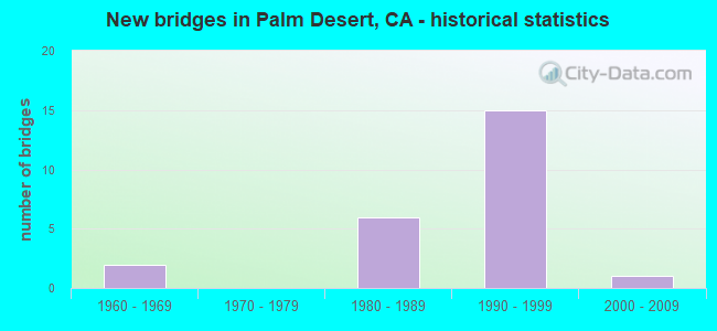
- New bridges - historical statistics
- 21960-1969
- 61980-1989
- 151990-1999
- 12000-2009

- Reconstructed bridges - Historical Statistics
- 11970-1979
- 11980-1989
- 01990-1999
- 12000-2009


- Bridge Condition - Deck
- 36.8%Good
- 63.2%Fair

- Bridge Condition - Superstructure
- 89.5%Good
- 10.5%Fair

- Bridge Condition - Substructure
- 89.5%Good
- 5.3%Satisfactory
- 5.3%Fair

- Bridge Condition - Channel
- 72.7%Excellent
- 18.2%Very good
- 9.1%Satisfactory
Find on map >> Show street view
Structure Number: 56 0780L, Location: 08-RIV-086-R11.94 (Lat: 33.583456, Lng: -116.096161), Route carried "on" structure: State highway 86, Year Built: 1998, Status: Open, Structure Length: 3.17m (10.40ft), Average Daily Traffic: 143,000 (year 2012), Truck Traffic: 20%, Average Future Daily Traffic: 177,936 (year 2038), Design Load: HS 20+Mod, Features Intersected: CVWD PIPELINE UC
Minimum Vertical Clearance: 30+ m (98+ ft), Kilometerpoint: 11.940, Lanes on structure: 2, Base Highway Network: Yes (Inventory Route: 8, Subroute: 1), Owner: State Highway Agency, Approaching Roadway Width: 11.9m (39.0ft), Skew: 4 degrees, Material/Design: Concrete, Design/Construction: Slab, Number Of Spans In Main Unit: 3, Length of Maximum Span: 10.9m (35.8ft), Curb-To-Curb Width: 11.9m (39.0ft), Out-to-Out Width: 11.9m (39.0ft)
Condition: Deck: Fair, Superstructure: Fair, Substructure: Good, Operating Rating: 54.1 metric tons, Method Used To Determine Operating Rating: Assigned rating based on Load Factor Design (LFD) reported in metric tons, Inventory Rating: 32.4 metric tons, Method Used To Determine Inventory Rating: Assigned rating based on Load Factor Design (LFD) reported in metric tons, Structural Evaluation: Somewhat better than minimum adequacy, Deck Geometry: Better than present minimum criteria, Approach Roadway Alignment: Equal to present desirable criteria, Designated Inspection Frequency: Every 24 months, Inspection Date: April 2021, Deck Structure Type: Concrete Cast-file-Place
Find on map >> Show street view
Structure Number: 56 0786S, Location: 08-RIV-010-46.80-PDST (Lat: 33.786369, Lng: -116.355950), Route carried "on" structure: Ramp Interstate 10, Year Built: 1998, Status: Open, Structure Length: 10.31m (33.83ft), Average Daily Traffic: 7,500 (year 2014), Truck Traffic: 8%, Average Future Daily Traffic: 12,242 (year 2040), Design Load: HS 20+Mod, Features Intersected: UNIMPROVED
Minimum Vertical Clearance: 30+ m (98+ ft), Kilometerpoint: 46.800, Lanes on structure: 3, Owner: State Highway Agency, Approaching Roadway Width: 14.5m (47.6ft), Material/Design: Prestressed concrete continuous, Design/Construction: Box Beam or Girders - Multiple, Number Of Spans In Main Unit: 4, Length of Maximum Span: 36.6m (120.1ft), Curb-To-Curb Width: 13.4m (44.0ft), Out-to-Out Width: 14.5m (47.6ft)
Condition: Deck: Fair, Superstructure: Good, Substructure: Good, Operating Rating: 54.1 metric tons, Method Used To Determine Operating Rating: Assigned rating based on Load Factor Design (LFD) reported in metric tons, Inventory Rating: 32.4 metric tons, Method Used To Determine Inventory Rating: Assigned rating based on Load Factor Design (LFD) reported in metric tons, Structural Evaluation: Better than present minimum criteria, Deck Geometry: Somewhat better than minimum adequacy, Approach Roadway Alignment: Equal to present desirable criteria, Designated Inspection Frequency: Every 24 months, Inspection Date: October 2021, Deck Structure Type: Concrete Cast-file-Place
Find on map >> Show street view
Structure Number: 56 0787, Location: 08-RIV-010-46.90-PDST (Lat: 33.786453, Lng: -116.354650), Route carried "on" structure: City street , Year Built: 1998, Status: Open, Structure Length: 7.80m (25.59ft), Average Daily Traffic: 6,500 (year 2014), Truck Traffic: 14%, Average Future Daily Traffic: 9,533 (year 2040), Design Load: HS 20+Mod, Features Intersected: INTERSTATE 10, Facility Carried by Structure: COOK STREET
Minimum Vertical Clearance: 30+ m (98+ ft), Kilometerpoint: 0.000, Lanes on structure: 7, Lanes under structure: 7, Owner: State Highway Agency, Approaching Roadway Width: 31.1m (102.0ft), Material/Design: Prestressed concrete continuous, Design/Construction: Box Beam or Girders - Multiple, Number Of Spans In Main Unit: 2, Length of Maximum Span: 41.1m (134.8ft), Curb or Sidewalk Widths: Left: 1.5m (4.9ft), Right: 0.0m, Curb-To-Curb Width: 31.1m (102.0ft), Out-to-Out Width: 33.5m (109.9ft)
Condition: Deck: Fair, Superstructure: Good, Substructure: Good, Operating Rating: 54.1 metric tons, Method Used To Determine Operating Rating: Assigned rating based on Load Factor Design (LFD) reported in metric tons, Inventory Rating: 32.4 metric tons, Method Used To Determine Inventory Rating: Assigned rating based on Load Factor Design (LFD) reported in metric tons, Structural Evaluation: Better than present minimum criteria, Deck Geometry: Better than present minimum criteria, Underclear: Equal to present minimum criteria, Approach Roadway Alignment: Equal to present desirable criteria, Designated Inspection Frequency: Every 24 months, Inspection Date: October 2021, Deck Structure Type: Concrete Cast-file-Place
Find on map >> Show street view
Structure Number: 56 0788S, Location: 08-RIV-010-47.00-PDST (Lat: 33.785583, Lng: -116.354778), Route carried "on" structure: Ramp Interstate 10, Year Built: 1998, Status: Open, Structure Length: 10.54m (34.58ft), Average Daily Traffic: 4,500 (year 2014), Truck Traffic: 32%, Average Future Daily Traffic: 7,651 (year 2040), Design Load: HS 20+Mod, Features Intersected: UNIMPROVED
Minimum Vertical Clearance: 30+ m (98+ ft), Kilometerpoint: 47.000, Lanes on structure: 1, Owner: State Highway Agency, Approaching Roadway Width: 9.7m (31.8ft), Material/Design: Prestressed concrete continuous, Design/Construction: Box Beam or Girders - Multiple, Number Of Spans In Main Unit: 4, Length of Maximum Span: 36.6m (120.1ft), Curb-To-Curb Width: 9.7m (31.8ft), Out-to-Out Width: 10.8m (35.4ft)
Condition: Deck: Fair, Superstructure: Good, Substructure: Good, Operating Rating: 54.1 metric tons, Method Used To Determine Operating Rating: Assigned rating based on Load Factor Design (LFD) reported in metric tons, Inventory Rating: 32.4 metric tons, Method Used To Determine Inventory Rating: Assigned rating based on Load Factor Design (LFD) reported in metric tons, Structural Evaluation: Better than present minimum criteria, Deck Geometry: Superior to present desirable criteria, Approach Roadway Alignment: Equal to present desirable criteria, Designated Inspection Frequency: Every 24 months, Inspection Date: October 2021, Deck Structure Type: Concrete Cast-file-Place
Find on map >> Show street view
Structure Number: 56 0793, Location: 08-RIV-010-44.54-PDST (Lat: 33.806761, Lng: -116.388356), Route carried "on" structure: County highway , Year Built: 1998, Status: Open, Structure Length: 7.50m (24.61ft), Average Daily Traffic: 10,560 (year 2014), Truck Traffic: 14%, Average Future Daily Traffic: 15,488 (year 2040), Design Load: HS 20+Mod, Features Intersected: INTERSTATE 10, Facility Carried by Structure: MONTEREY AVE
Minimum Vertical Clearance: 30+ m (98+ ft), Kilometerpoint: 0.000, Lanes on structure: 7, Lanes under structure: 6, Owner: State Highway Agency, Approaching Roadway Width: 30.5m (100.1ft), Skew: 2 degrees, Material/Design: Prestressed concrete continuous, Design/Construction: Box Beam or Girders - Multiple, Number Of Spans In Main Unit: 2, Length of Maximum Span: 39.2m (128.6ft), Curb or Sidewalk Widths: Left: 1.5m (4.9ft), Right: 0.0m, Curb-To-Curb Width: 30.5m (100.1ft), Out-to-Out Width: 32.8m (107.6ft)
Condition: Deck: Fair, Superstructure: Good, Substructure: Good, Operating Rating: 54.1 metric tons, Method Used To Determine Operating Rating: Assigned rating based on Load Factor Design (LFD) reported in metric tons, Inventory Rating: 32.4 metric tons, Method Used To Determine Inventory Rating: Assigned rating based on Load Factor Design (LFD) reported in metric tons, Structural Evaluation: Better than present minimum criteria, Deck Geometry: Better than present minimum criteria, Underclear: Equal to present minimum criteria, Approach Roadway Alignment: Equal to present desirable criteria, Designated Inspection Frequency: Every 24 months, Inspection Date: October 2021, Deck Structure Type: Concrete Cast-file-Place
Find on map >> Show street view
Structure Number: 56 0796, Location: 08-RIV-010-50.50-PDST (Lat: 33.760875, Lng: -116.301425), Route carried "on" structure: County highway , Year Built: 1998, Status: Open, Structure Length: 7.80m (25.59ft), Average Daily Traffic: 22,400 (year 2012), Truck Traffic: 14%, Average Future Daily Traffic: 45,908 (year 2038), Design Load: HS 20+Mod, Features Intersected: INTERSTATE 10, Facility Carried by Structure: WASHINGTON STREET
Minimum Vertical Clearance: 30+ m (98+ ft), Kilometerpoint: 0.000, Lanes on structure: 9, Lanes under structure: 7, Owner: State Highway Agency, Approaching Roadway Width: 38.4m (126.0ft), Material/Design: Prestressed concrete continuous, Design/Construction: Box Beam or Girders - Multiple, Number Of Spans In Main Unit: 2, Length of Maximum Span: 45.6m (149.6ft), Curb or Sidewalk Widths: Left: 1.8m (5.9ft), Right: 0.0m, Curb-To-Curb Width: 38.4m (126.0ft), Out-to-Out Width: 41.0m (134.5ft)
Condition: Deck: Fair, Superstructure: Good, Substructure: Good, Operating Rating: 54.1 metric tons, Method Used To Determine Operating Rating: Assigned rating based on Load Factor Design (LFD) reported in metric tons, Inventory Rating: 32.4 metric tons, Method Used To Determine Inventory Rating: Assigned rating based on Load Factor Design (LFD) reported in metric tons, Structural Evaluation: Better than present minimum criteria, Deck Geometry: Better than present minimum criteria, Underclear: Better than present minimum criteria, Approach Roadway Alignment: Equal to present desirable criteria, Designated Inspection Frequency: Every 24 months, Inspection Date: October 2021, Deck Structure Type: Concrete Cast-file-Place
Find on map >> Show street view
Structure Number: 56C0167, Location: 0.2 MI. E/O RTE. 111 HWY. (Lat: 33.728472, Lng: -116.399967), Route carried "on" structure: City street , Year Built: 1965, Year Reconstructed: 1984, Status: Open, Structure Length: 2.50m (8.20ft), Average Daily Traffic: 20,000 (year 2018), Truck Traffic: 1%, Average Future Daily Traffic: 41,216 (year 2037), Design Load: HS 20, Features Intersected: PALM VLY STRMWTR CHANNEL, Facility Carried by Structure: FRED WARING DRIVE
Minimum Vertical Clearance: 30+ m (98+ ft), Kilometerpoint: 0.000, Lanes on structure: 6, Owner: City or Municipal Highway Agency, Approaching Roadway Width: 24.0m (78.7ft), Skew: 20 degrees, Material/Design: Concrete continuous, Design/Construction: Slab, Number Of Spans In Main Unit: 2, Length of Maximum Span: 12.2m (40.0ft), Curb or Sidewalk Widths: Left: 2.0m (6.6ft), Right: 2.0m (6.6ft), Curb-To-Curb Width: 24.0m (78.7ft), Out-to-Out Width: 36.3m (119.1ft)
Condition: Deck: Good, Superstructure: Good, Substructure: Good, Channel: Excellent, Operating Rating: 83.6 metric tons, Method Used To Determine Operating Rating: Load Factor (LF), Inventory Rating: 50.2 metric tons, Method Used To Determine Inventory Rating: Load Factor (LF), Structural Evaluation: Better than present minimum criteria, Deck Geometry: Somewhat better than minimum adequacy, Waterway Adequacy: Superior to present desirable criteria, Approach Roadway Alignment: Equal to present desirable criteria, Designated Inspection Frequency: Every 48 months, Inspection Date: November 2018, Deck Structure Type: Concrete Cast-file-Place, Wearing Surface/Protective System: Wearing Surface: Bituminous
Find on map >> Show street view
Structure Number: 56C0321, Location: 0.3 MI. E/O JOY STREET (Lat: 33.883128, Lng: -117.555489), Route carried "on" structure: City street , Year Built: 1983, Status: Open, Structure Length: 4.21m (13.81ft), Average Daily Traffic: 3,000 (year 2012), Truck Traffic: 1%, Average Future Daily Traffic: 6,307 (year 2040), Design Load: HS 20, Features Intersected: TEMESCAL CREEK CHANNEL, Facility Carried by Structure: HARRISON STREET
Minimum Vertical Clearance: 30+ m (98+ ft), Kilometerpoint: 0.000, Lanes on structure: 2, Owner: City or Municipal Highway Agency, Approaching Roadway Width: 13.3m (43.6ft), Skew: 20 degrees, Material/Design: Prestressed concrete, Design/Construction: Stringer/Multi-beam, Number Of Spans In Main Unit: 3, Length of Maximum Span: 14.0m (45.9ft), Curb or Sidewalk Widths: Left: 1.2m (3.9ft), Right: 1.2m (3.9ft), Curb-To-Curb Width: 13.3m (43.6ft), Out-to-Out Width: 16.5m (54.1ft)
Condition: Deck: Fair, Superstructure: Good, Substructure: Fair, Channel: Excellent, Operating Rating: 81.0 metric tons, Method Used To Determine Operating Rating: Load Factor (LF), Inventory Rating: 32.4 metric tons, Method Used To Determine Inventory Rating: Load Factor (LF), Structural Evaluation: Somewhat better than minimum adequacy, Deck Geometry: Equal to present minimum criteria, Waterway Adequacy: Superior to present desirable criteria, Approach Roadway Alignment: Better than present minimum criteria, Designated Inspection Frequency: Every 24 months, Inspection Date: January 2021, Deck Structure Type: Concrete Cast-file-Place
Find on map >> Show street view
Structure Number: 56C0326, Location: 200' W/O EDGEHILL DRIVE (Lat: 33.714194, Lng: -116.399850), Route carried "on" structure: City street , Year Built: 1984, Status: Open, Structure Length: 2.56m (8.40ft), Average Daily Traffic: 300 (year 2017), Truck Traffic: 1%, Average Future Daily Traffic: 313 (year 2036), Design Load: HS 20, Features Intersected: PALM VLY STRMWTR CHANNEL, Facility Carried by Structure: TIERRA DEL ORO
Minimum Vertical Clearance: 30+ m (98+ ft), Kilometerpoint: 0.000, Lanes on structure: 2, Owner: City or Municipal Highway Agency, Approaching Roadway Width: 7.3m (24.0ft), Skew: 1 degrees, Material/Design: Prestressed concrete, Design/Construction: Stringer/Multi-beam, Number Of Spans In Main Unit: 1, Length of Maximum Span: 24.7m (81.0ft), Curb or Sidewalk Widths: Left: 0.0m, Right: 1.2m (3.9ft), Curb-To-Curb Width: 7.3m (24.0ft), Out-to-Out Width: 9.4m (30.8ft)
Condition: Deck: Good, Superstructure: Good, Substructure: Good, Channel: Excellent, Operating Rating: 54.1 metric tons, Method Used To Determine Operating Rating: Assigned rating based on Load Factor Design (LFD) reported in metric tons, Inventory Rating: 32.4 metric tons, Method Used To Determine Inventory Rating: Assigned rating based on Load Factor Design (LFD) reported in metric tons, Structural Evaluation: Better than present minimum criteria, Deck Geometry: Somewhat better than minimum adequacy, Waterway Adequacy: Equal to present desirable criteria, Approach Roadway Alignment: Equal to present minimum criteria, Designated Inspection Frequency: Every 48 months, Inspection Date: November 2018, Deck Structure Type: Concrete Cast-file-Place
Find on map >> Show street view
Structure Number: 56C0327, Location: 0.2 MI. W/O RTE. 74 HWY. (Lat: 33.706261, Lng: -116.398533), Route carried "on" structure: City street , Year Built: 1984, Status: Open, Structure Length: 2.56m (8.40ft), Average Daily Traffic: 200 (year 2018), Truck Traffic: 1%, Average Future Daily Traffic: 100 (year 2037), Design Load: HS 20, Features Intersected: PALM VLY STRMWTR CHANNEL, Facility Carried by Structure: THRUSH ROAD
Minimum Vertical Clearance: 30+ m (98+ ft), Kilometerpoint: 0.000, Lanes on structure: 2, Owner: City or Municipal Highway Agency, Approaching Roadway Width: 7.3m (24.0ft), Material/Design: Prestressed concrete, Design/Construction: Stringer/Multi-beam, Number Of Spans In Main Unit: 1, Length of Maximum Span: 24.7m (81.0ft), Curb or Sidewalk Widths: Left: 0.0m, Right: 1.2m (3.9ft), Curb-To-Curb Width: 7.3m (24.0ft), Out-to-Out Width: 9.4m (30.8ft)
Condition: Deck: Good, Superstructure: Good, Substructure: Good, Channel: Excellent, Operating Rating: 54.1 metric tons, Method Used To Determine Operating Rating: Assigned rating based on Load Factor Design (LFD) reported in metric tons, Inventory Rating: 32.4 metric tons, Method Used To Determine Inventory Rating: Assigned rating based on Load Factor Design (LFD) reported in metric tons, Structural Evaluation: Better than present minimum criteria, Deck Geometry: Somewhat better than minimum adequacy, Waterway Adequacy: Equal to present desirable criteria, Approach Roadway Alignment: High priority of corrective action, Designated Inspection Frequency: Every 48 months, Inspection Date: November 2018, Deck Structure Type: Concrete Cast-file-Place
Find on map >> Show street view
Structure Number: 56C0328, Location: AT CANYON ROAD (Lat: 33.688644, Lng: -116.408814), Route carried "on" structure: County highway , Year Built: 1984, Status: Open, Structure Length: 1.52m (4.99ft), Average Daily Traffic: 274 (year 2015), Truck Traffic: 1%, Average Future Daily Traffic: 1,076 (year 2044), Features Intersected: PALM VALY STORMWTR CHANN, Facility Carried by Structure: CHOLLA WAY
Minimum Vertical Clearance: 30+ m (98+ ft), Kilometerpoint: 0.000, Lanes on structure: 2, Owner: County Highway Agency, Approaching Roadway Width: 7.0m (23.0ft), Skew: 2 degrees, Material/Design: Prestressed concrete, Design/Construction: Stringer/Multi-beam, Number Of Spans In Main Unit: 1, Length of Maximum Span: 14.6m (47.9ft), Curb or Sidewalk Widths: Left: 0.0m, Right: 1.5m (4.9ft), Curb-To-Curb Width: 9.8m (32.2ft), Out-to-Out Width: 12.1m (39.7ft)
Condition: Deck: Fair, Superstructure: Good, Substructure: Good, Channel: Excellent, Operating Rating: 54.1 metric tons, Method Used To Determine Operating Rating: Field evaluation and documented engineering judgment, Inventory Rating: 32.4 metric tons, Method Used To Determine Inventory Rating: Field evaluation and documented engineering judgment, Structural Evaluation: Better than present minimum criteria, Deck Geometry: Better than present minimum criteria, Waterway Adequacy: Superior to present desirable criteria, Approach Roadway Alignment: Equal to present minimum criteria, Designated Inspection Frequency: Every 24 months, Inspection Date: Febuary 2022, Deck Structure Type: Concrete Cast-file-Place
Find on map >> Show street view
Structure Number: 56C0329, Location: 0.34 MI. E/O RTE. 111 HWY (Lat: 33.732144, Lng: -116.399922), Route carried "on" structure: City street , Year Built: 1984, Status: Open, Structure Length: 3.14m (10.30ft), Average Daily Traffic: 6,200 (year 2018), Truck Traffic: 2%, Average Future Daily Traffic: 10,338 (year 2037), Design Load: HS 20, Features Intersected: PALM VLY STRMWTR CHANNEL, Facility Carried by Structure: PARK VIEW DRIVE
Minimum Vertical Clearance: 30+ m (98+ ft), Kilometerpoint: 0.000, Lanes on structure: 3, Owner: City or Municipal Highway Agency, Approaching Roadway Width: 14.9m (48.9ft), Material/Design: Prestressed concrete, Design/Construction: Stringer/Multi-beam, Number Of Spans In Main Unit: 2, Length of Maximum Span: 15.2m (49.9ft), Curb or Sidewalk Widths: Left: 0.0m, Right: 1.5m (4.9ft), Curb-To-Curb Width: 15.5m (50.9ft), Out-to-Out Width: 18.0m (59.1ft)
Condition: Deck: Good, Superstructure: Good, Substructure: Good, Channel: Excellent, Operating Rating: 54.1 metric tons, Method Used To Determine Operating Rating: Assigned rating based on Load Factor Design (LFD) reported in metric tons, Inventory Rating: 32.4 metric tons, Method Used To Determine Inventory Rating: Assigned rating based on Load Factor Design (LFD) reported in metric tons, Structural Evaluation: Better than present minimum criteria, Deck Geometry: Equal to present minimum criteria, Waterway Adequacy: Equal to present desirable criteria, Approach Roadway Alignment: Equal to present desirable criteria, Designated Inspection Frequency: Every 48 months, Inspection Date: November 2018, Deck Structure Type: Concrete Cast-file-Place
Find on map >> Show street view
Structure Number: 56C034, Location: 0.0 MI. W/O ROUTE 215 FWY (Lat: 33.908478, Lng: -117.283772), Route carried "on" structure: County highway , Year Built: 1993, Year Reconstructed: 2008, Status: Open, Structure Length: 4.21m (13.81ft), Average Daily Traffic: 9,110 (year 2012), Truck Traffic: 1%, Average Future Daily Traffic: 5,222 (year 2040), Design Load: HS 20+Mod, Features Intersected: RCTC & BNSF RY, Facility Carried by Structure: CACTUS AVENUE
Minimum Vertical Clearance: 30+ m (98+ ft), Kilometerpoint: 0.000, Lanes on structure: 4, Owner: County Highway Agency, Approaching Roadway Width: 26.0m (85.3ft), Skew: 23 degrees, Material/Design: Prestressed concrete continuous, Design/Construction: Slab, Number Of Spans In Main Unit: 3, Length of Maximum Span: 15.8m (51.8ft), Curb-To-Curb Width: 26.0m (85.3ft), Out-to-Out Width: 35.5m (116.5ft)
Condition: Deck: Fair, Superstructure: Fair, Substructure: Good, Operating Rating: 54.1 metric tons, Method Used To Determine Operating Rating: Assigned rating based on Load Factor Design (LFD) reported in metric tons, Inventory Rating: 32.4 metric tons, Method Used To Determine Inventory Rating: Assigned rating based on Load Factor Design (LFD) reported in metric tons, Structural Evaluation: Somewhat better than minimum adequacy, Deck Geometry: Superior to present desirable criteria, Underclear: Equal to present minimum criteria, Approach Roadway Alignment: Equal to present desirable criteria, Designated Inspection Frequency: Every 24 months, Inspection Date: April 2020, Deck Structure Type: Concrete Cast-file-Place
Find on map >> Show street view
Structure Number: 56C0347, Location: 200' N/O HAYSTACK ROAD (Lat: 33.703361, Lng: -116.373817), Route carried "on" structure: City street , Year Built: 1984, Status: Open, Structure Length: 1.31m (4.30ft), Average Daily Traffic: 11,000 (year 2017), Truck Traffic: 1%, Average Future Daily Traffic: 22,670 (year 2036), Features Intersected: HAYSTACK CHANNEL, Facility Carried by Structure: PORTOLA AVENUE
Minimum Vertical Clearance: 30+ m (98+ ft), Kilometerpoint: 0.000, Lanes on structure: 3, Owner: City or Municipal Highway Agency, Approaching Roadway Width: 14.3m (46.9ft), Skew: 3 degrees, Material/Design: Concrete, Design/Construction: Culvert, Number Of Spans In Main Unit: 5, Length of Maximum Span: 2.3m (7.5ft), Curb or Sidewalk Widths: Left: 0.0m, Right: 2.6m (8.5ft), Curb-To-Curb Width: 14.9m (48.9ft), Out-to-Out Width: 18.5m (60.7ft)
Condition: Channel: Satisfactory, Culverts: Good, Operating Rating: 54.1 metric tons, Method Used To Determine Operating Rating: Field evaluation and documented engineering judgment, Inventory Rating: 32.4 metric tons, Method Used To Determine Inventory Rating: Field evaluation and documented engineering judgment, Structural Evaluation: Better than present minimum criteria, Deck Geometry: Equal to present minimum criteria, Waterway Adequacy: Better than present minimum criteria, Approach Roadway Alignment: Equal to present desirable criteria, Designated Inspection Frequency: Every 48 months, Inspection Date: November 2018
Find on map >> Show street view
Structure Number: 56C0448L, Location: 0.1 MI. S/O ROUTE 10 FWY. (Lat: 33.804792, Lng: -116.388214), Route carried "on" structure: County highway , Year Built: 1996, Status: Open, Structure Length: 9.62m (31.56ft), Average Daily Traffic: 12,000 (year 2019), Truck Traffic: 1%, Average Future Daily Traffic: 31,852 (year 2044), Design Load: HS 20+Mod, Features Intersected: UP RR & AMTRAK, Facility Carried by Structure: MONTEREY AVENUE SB
Minimum Vertical Clearance: 30+ m (98+ ft), Kilometerpoint: 0.000, Lanes on structure: 3, Owner: County Highway Agency, Approaching Roadway Width: 14.6m (47.9ft), Skew: 3 degrees, Material/Design: Prestressed concrete continuous, Design/Construction: Box Beam or Girders - Multiple, Number Of Spans In Main Unit: 3, Length of Maximum Span: 37.9m (124.3ft), Curb or Sidewalk Widths: Left: 1.5m (4.9ft), Right: 0.0m, Curb-To-Curb Width: 14.6m (47.9ft), Out-to-Out Width: 16.9m (55.4ft)
Condition: Deck: Fair, Superstructure: Good, Substructure: Good, Operating Rating: 54.1 metric tons, Method Used To Determine Operating Rating: Assigned rating based on Load Factor Design (LFD) reported in metric tons, Inventory Rating: 32.4 metric tons, Method Used To Determine Inventory Rating: Assigned rating based on Load Factor Design (LFD) reported in metric tons, Structural Evaluation: Better than present minimum criteria, Deck Geometry: Somewhat better than minimum adequacy, Underclear: Superior to present desirable criteria, Approach Roadway Alignment: Equal to present desirable criteria, Designated Inspection Frequency: Every 24 months, Inspection Date: Febuary 2022, Deck Structure Type: Concrete Cast-file-Place
Find on map >> Show street view
Structure Number: 56C0448R, Location: 0.1 MI. S/O ROUTE 10 FWY. (Lat: 33.804589, Lng: -116.387958), Route carried "on" structure: County highway , Year Built: 1996, Status: Open, Structure Length: 9.62m (31.56ft), Average Daily Traffic: 12,000 (year 2019), Truck Traffic: 1%, Average Future Daily Traffic: 31,852 (year 2044), Design Load: HS 20+Mod, Features Intersected: UP RR & AMTRAK, Facility Carried by Structure: MONTEREY AVENUE NB
Minimum Vertical Clearance: 30+ m (98+ ft), Kilometerpoint: 0.000, Lanes on structure: 4, Owner: County Highway Agency, Approaching Roadway Width: 18.4m (60.4ft), Skew: 3 degrees, Material/Design: Prestressed concrete continuous, Design/Construction: Box Beam or Girders - Multiple, Number Of Spans In Main Unit: 3, Length of Maximum Span: 37.9m (124.3ft), Curb-To-Curb Width: 18.4m (60.4ft), Out-to-Out Width: 19.4m (63.6ft)
Condition: Deck: Fair, Superstructure: Good, Substructure: Good, Operating Rating: 54.1 metric tons, Method Used To Determine Operating Rating: Assigned rating based on Load Factor Design (LFD) reported in metric tons, Inventory Rating: 32.4 metric tons, Method Used To Determine Inventory Rating: Assigned rating based on Load Factor Design (LFD) reported in metric tons, Structural Evaluation: Better than present minimum criteria, Deck Geometry: Somewhat better than minimum adequacy, Underclear: Superior to present desirable criteria, Approach Roadway Alignment: Equal to present desirable criteria, Designated Inspection Frequency: Every 24 months, Inspection Date: Febuary 2022, Deck Structure Type: Concrete Cast-file-Place
Find on map >> Show street view
Structure Number: 56C0467, Location: 0.9 MI N/O FRED WARING DR (Lat: 33.740661, Lng: -116.391053), Route carried "on" structure: City street , Year Built: 1996, Status: Open, Structure Length: 11.99m (39.34ft), Average Daily Traffic: 30,000 (year 2018), Truck Traffic: 1%, Average Future Daily Traffic: 61,824 (year 2037), Design Load: HS 20+Mod, Features Intersected: WHITEWATER RIVER, Facility Carried by Structure: MONTEREY AVENUE
Minimum Vertical Clearance: 30+ m (98+ ft), Kilometerpoint: 0.000, Lanes on structure: 5, Base Highway Network: Yes, Owner: City or Municipal Highway Agency, Approaching Roadway Width: 26.8m (87.9ft), Material/Design: Concrete continuous, Design/Construction: Stringer/Multi-beam, Number Of Spans In Main Unit: 4, Length of Maximum Span: 29.9m (98.1ft), Curb or Sidewalk Widths: Left: 1.5m (4.9ft), Right: 2.0m (6.6ft), Curb-To-Curb Width: 23.5m (77.1ft), Out-to-Out Width: 27.9m (91.5ft)
Condition: Deck: Good, Superstructure: Good, Substructure: Good, Channel: Excellent, Operating Rating: 54.1 metric tons, Method Used To Determine Operating Rating: Assigned rating based on Load Factor Design (LFD) reported in metric tons, Inventory Rating: 32.4 metric tons, Method Used To Determine Inventory Rating: Assigned rating based on Load Factor Design (LFD) reported in metric tons, Structural Evaluation: Better than present minimum criteria, Deck Geometry: Better than present minimum criteria, Waterway Adequacy: Equal to present desirable criteria, Approach Roadway Alignment: Equal to present desirable criteria, Designated Inspection Frequency: Every 48 months, Inspection Date: November 2018, Deck Structure Type: Concrete Cast-file-Place, Wearing Surface/Protective System: Wearing Surface: Bituminous
Find on map >> Show street view
Structure Number: 56C0486, Location: 0.1 MI. S/O ROUTE 10 FWY. (Lat: 33.785197, Lng: -116.355017), Route carried "on" structure: County highway , Year Built: 1997, Status: Open, Structure Length: 14.63m (48.00ft), Average Daily Traffic: 27,908 (year 2013), Truck Traffic: 1%, Average Future Daily Traffic: 42,470 (year 2044), Design Load: HS 20+Mod, Features Intersected: UP RR & AMTRAK, Facility Carried by Structure: COOK STREET
Minimum Vertical Clearance: 30+ m (98+ ft), Kilometerpoint: 0.000, Lanes on structure: 6, Owner: County Highway Agency, Approaching Roadway Width: 31.1m (102.0ft), Material/Design: Prestressed concrete continuous, Design/Construction: Box Beam or Girders - Multiple, Number Of Spans In Main Unit: 4, Length of Maximum Span: 36.6m (120.1ft), Curb or Sidewalk Widths: Left: 1.5m (4.9ft), Right: 0.0m, Curb-To-Curb Width: 31.1m (102.0ft), Out-to-Out Width: 33.5m (109.9ft)
Condition: Deck: Good, Superstructure: Good, Substructure: Satisfactory, Operating Rating: 54.1 metric tons, Method Used To Determine Operating Rating: Assigned rating based on Load Factor Design (LFD) reported in metric tons, Inventory Rating: 32.4 metric tons, Method Used To Determine Inventory Rating: Assigned rating based on Load Factor Design (LFD) reported in metric tons, Structural Evaluation: Equal to present minimum criteria, Deck Geometry: Superior to present desirable criteria, Underclear: Better than present minimum criteria, Approach Roadway Alignment: Equal to present desirable criteria, Designated Inspection Frequency: Every 24 months, Inspection Date: Febuary 2022, Deck Structure Type: Concrete Cast-file-Place
Find on map >> Show street view
Structure Number: 56C0494, Location: 0.4 MI N/O FRED WARING DR (Lat: 33.734158, Lng: -116.356069), Route carried "on" structure: City street , Year Built: 1993, Status: Open, Structure Length: 3.90m (12.80ft), Average Daily Traffic: 27,000 (year 2017), Truck Traffic: 1%, Average Future Daily Traffic: 57,143 (year 2042), Features Intersected: WHITEWATER RIVER, Facility Carried by Structure: COOK STREET
Minimum Vertical Clearance: 30+ m (98+ ft), Kilometerpoint: 0.000, Lanes on structure: 4, Base Highway Network: Yes, Owner: City or Municipal Highway Agency, Approaching Roadway Width: 20.7m (67.9ft), Skew: 1 degrees, Design/Construction: Culvert, Number Of Spans In Main Unit: 4, Length of Maximum Span: 9.1m (29.9ft), Curb or Sidewalk Widths: Left: 3.6m (11.8ft), Right: 0.0m, Curb-To-Curb Width: 20.7m (67.9ft), Out-to-Out Width: 24.4m (80.1ft)
Condition: Channel: Excellent, Culverts: Good, Operating Rating: 54.1 metric tons, Method Used To Determine Operating Rating: Field evaluation and documented engineering judgment, Inventory Rating: 32.4 metric tons, Method Used To Determine Inventory Rating: Field evaluation and documented engineering judgment, Structural Evaluation: Better than present minimum criteria, Deck Geometry: Superior to present desirable criteria, Waterway Adequacy: Equal to present desirable criteria, Approach Roadway Alignment: Equal to present desirable criteria, Designated Inspection Frequency: Every 24 months, Inspection Date: November 2020
Find on map >> Show street view
Structure Number: 56C0549, Location: 0.7 MI N/O FRED WARING DR (Lat: 33.737683, Lng: -116.373597), Route carried "on" structure: City street , Year Built: 2007, Status: Open, Structure Length: 13.32m (43.70ft), Average Daily Traffic: 21,000 (year 2017), Truck Traffic: 1%, Average Future Daily Traffic: 43,566 (year 2042), Design Load: HS 20, Features Intersected: WHITEWATER RIVER, Facility Carried by Structure: PORTOLA AVENUE
Minimum Vertical Clearance: 30+ m (98+ ft), Kilometerpoint: 0.000, Lanes on structure: 5, Owner: City or Municipal Highway Agency, Approaching Roadway Width: 20.8m (68.2ft), Skew: 1 degrees, Material/Design: Prestressed concrete continuous, Design/Construction: Stringer/Multi-beam, Number Of Spans In Main Unit: 4, Length of Maximum Span: 33.3m (109.3ft), Curb or Sidewalk Widths: Left: 2.6m (8.5ft), Right: 2.6m (8.5ft), Curb-To-Curb Width: 26.6m (87.3ft), Out-to-Out Width: 32.6m (107.0ft)
Condition: Deck: Fair, Superstructure: Good, Substructure: Good, Channel: Very good, Operating Rating: 54.1 metric tons, Method Used To Determine Operating Rating: Assigned rating based on Load Factor Design (LFD) reported in metric tons, Inventory Rating: 32.4 metric tons, Method Used To Determine Inventory Rating: Assigned rating based on Load Factor Design (LFD) reported in metric tons, Structural Evaluation: Better than present minimum criteria, Deck Geometry: Superior to present desirable criteria, Waterway Adequacy: Equal to present desirable criteria, Approach Roadway Alignment: Equal to present desirable criteria, Designated Inspection Frequency: Every 24 months, Inspection Date: November 2020, Deck Structure Type: Concrete Cast-file-Place, Wearing Surface/Protective System: Wearing Surface: Bituminous
Find on map >> Show street view
Structure Number: 56C0594, Location: 0.2 MI NW OF TOWN CENTER (Lat: 33.725664, Lng: -116.400589), Route carried "on" structure: City street , Year Built: 1964, Year Reconstructed: 1988, Status: Open, Structure Length: 2.75m (9.02ft), Average Daily Traffic: 31,000 (year 2018), Truck Traffic: 8%, Average Future Daily Traffic: 38,252 (year 2037), Design Load: HS 20, Features Intersected: PALM VALLEY CHANNEL, Facility Carried by Structure: PALM CANYON BLVD
Minimum Vertical Clearance: 30+ m (98+ ft), Kilometerpoint: 0.000, Lanes on structure: 6, Base Highway Network: Yes, Owner: City or Municipal Highway Agency, Approaching Roadway Width: 23.2m (76.1ft), Skew: 33 degrees, Material/Design: Concrete continuous, Design/Construction: Slab, Number Of Spans In Main Unit: 2, Length of Maximum Span: 13.4m (44.0ft), Curb or Sidewalk Widths: Left: 1.6m (5.2ft), Right: 1.6m (5.2ft), Curb-To-Curb Width: 23.2m (76.1ft), Out-to-Out Width: 30.5m (100.1ft)
Condition: Deck: Good, Superstructure: Good, Substructure: Good, Channel: Very good, Operating Rating: 71.0 metric tons, Method Used To Determine Operating Rating: Load Factor (LF), Inventory Rating: 42.8 metric tons, Method Used To Determine Inventory Rating: Load Factor (LF), Structural Evaluation: Better than present minimum criteria, Deck Geometry: Meets minimum limits, Waterway Adequacy: Equal to present desirable criteria, Approach Roadway Alignment: Equal to present desirable criteria, Designated Inspection Frequency: Every 48 months, Inspection Date: November 2018, Deck Structure Type: Concrete Cast-file-Place, Wearing Surface/Protective System: Wearing Surface: Bituminous
Find on map >> Show street view
Structure Number: 56 0787, Location: 08-RIV-010-46.90-PDST (Lat: 33.786453, Lng: -116.354650), Route carried "under" structure: Interstate 10, Year Built: 1998, Structure Length: 0. m, Average Daily Traffic: 102,000 (year 2014), Truck Traffic: 32%, Features Intersected: INTERSTATE 10, Facility Carried by Structure: COOK STREET
Minimum Vertical Clearance: 6.71m (22.01ft), Kilometerpoint: 46.900, Lanes on structure: 7, Lanes under structure: 7, Material/Design: Prestressed concrete continuous, Design/Construction: Box Beam or Girders - Multiple, Length of Maximum Span: 41.1m (134.8ft)
Find on map >> Show street view
Structure Number: 56 0793, Location: 08-RIV-010-44.54-PDST (Lat: 33.806761, Lng: -116.388356), Route carried "under" structure: Interstate 10, Year Built: 1998, Structure Length: 0. m, Average Daily Traffic: 96,000 (year 2014), Truck Traffic: 16%, Features Intersected: INTERSTATE 10, Facility Carried by Structure: MONTEREY AVE
Minimum Vertical Clearance: 5.69m (18.67ft), Kilometerpoint: 44.540, Lanes on structure: 7, Lanes under structure: 6, Material/Design: Prestressed concrete continuous, Design/Construction: Box Beam or Girders - Multiple, Length of Maximum Span: 39.2m (128.6ft)
Find on map >> Show street view
Structure Number: 56 0796, Location: 08-RIV-010-50.50-PDST (Lat: 33.760875, Lng: -116.301425), Route carried "under" structure: Interstate 10, Year Built: 1998, Structure Length: 0. m, Average Daily Traffic: 90,000 (year 2012), Truck Traffic: 33%, Features Intersected: INTERSTATE 10, Facility Carried by Structure: WASHINGTON STREET
Minimum Vertical Clearance: 7.16m (23.49ft), Kilometerpoint: 50.500, Lanes on structure: 9, Lanes under structure: 7, Material/Design: Prestressed concrete continuous, Design/Construction: Box Beam or Girders - Multiple, Length of Maximum Span: 45.6m (149.6ft)