Bridge Statistics for Owings Mills, Maryland (MD)
Condition, Traffic, Stress, Structural Evaluation, Project Costs
- National Bridge Inventory (NBI) Statistics
- 43Number of bridges
- 381ft / 116mTotal length
- $8,231,000Total costs
- 1,114,384Total average daily traffic
- 44,400Total average daily truck traffic
- National Bridge Inventory (NBI) Registered Bridges for Owings Mills
- No street view available for this location
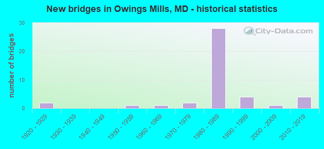
- New bridges - historical statistics
- 21920-1929
- 11950-1959
- 11960-1969
- 21970-1979
- 281980-1989
- 41990-1999
- 12000-2009
- 42010-2019

- Reconstructed bridges - Historical Statistics
- 11990-1999
- 02000-2009
- 22010-2019


- Bridge Condition - Deck
- 9.1%Very good
- 68.2%Good
- 18.2%Satisfactory
- 4.5%Fair

- Bridge Condition - Superstructure
- 18.2%Very good
- 40.9%Good
- 36.4%Satisfactory
- 4.5%Poor

- Bridge Condition - Substructure
- 13.6%Very good
- 50.0%Good
- 27.3%Satisfactory
- 4.5%Fair
- 4.5%Poor

- Bridge Condition - Channel
- 5.0%Very good
- 55.0%Good
- 25.0%Satisfactory
- 15.0%Fair

- Bridge Condition - Culverts
- 83.3%Good
- 16.7%Satisfactory
Find on map >> Show street view
Structure Number: 100000030317012, Location: 0.82 MI N OF MCDONOUGH RD (Lat: 39.402167, Lng: -76.765867), Route carried "on" structure: Interstate 795, Year Built: 1984, Status: Open, Structure Length: 9.88m (32.41ft), Average Daily Traffic: 110,982 (year 2009), Truck Traffic: 8%, Average Future Daily Traffic: 60,350 (year 2026), Design Load: HS 20, Features Intersected: CSX TRANSPORTATION
Minimum Vertical Clearance: 30+ m (98+ ft), Kilometerpoint: 3.791, Lanes on structure: 3, Base Highway Network: Yes, Owner: State Highway Agency, Approaching Roadway Width: 17.4m (57.1ft), Skew: 9 degrees, Material/Design: Steel continuous, Design/Construction: Stringer/Multi-beam, Number Of Spans In Main Unit: 3, Length of Maximum Span: 36.0m (118.1ft), Curb-To-Curb Width: 17.5m (57.4ft), Out-to-Out Width: 18.6m (61.0ft)
Condition: Deck: Good, Superstructure: Satisfactory, Substructure: Good, Inventory Rating: 57.1 metric tons, Method Used To Determine Inventory Rating: Load Factor (LF), Structural Evaluation: Equal to present minimum criteria, Deck Geometry: Better than present minimum criteria, Underclear: Better than present minimum criteria, Approach Roadway Alignment: Equal to present minimum criteria, Designated Inspection Frequency: Every 24 months, Inspection Date: September 2021, Deck Structure Type: Concrete Cast-file-Place, Wearing Surface/Protective System: Wearing Surface: Monolithic Concrete, Deck Protection: Epoxy Coated Reinforcing
Find on map >> Show street view
Structure Number: 10000003032101, Location: 0.43 MI S OF MD 940 (Lat: 39.409339, Lng: -76.782967), Route carried "on" structure: Ramp Interstate 795, Year Built: 1986, Status: Open, Structure Length: 3.78m (12.40ft), Average Daily Traffic: 15,802 (year 2008), Truck Traffic: 8%, Average Future Daily Traffic: 17,066 (year 2028), Design Load: HS 20, Features Intersected: IS 795 RAMP 'NB'(10)
Minimum Vertical Clearance: 30+ m (98+ ft), Kilometerpoint: 0.579, Lanes on structure: 2, Lanes under structure: 2, Base Highway Network: Yes, Owner: State Highway Agency, Approaching Roadway Width: 11.6m (38.1ft), Skew: 4 degrees, Material/Design: Steel, Design/Construction: Stringer/Multi-beam, Number Of Spans In Main Unit: 1, Length of Maximum Span: 35.4m (116.1ft), Curb-To-Curb Width: 11.6m (38.1ft), Out-to-Out Width: 12.8m (42.0ft)
Condition: Deck: Good, Superstructure: Satisfactory, Substructure: Satisfactory, Inventory Rating: 73.5 metric tons, Method Used To Determine Inventory Rating: Load Factor (LF), Structural Evaluation: Equal to present minimum criteria, Deck Geometry: Superior to present desirable criteria, Underclear: Equal to present desirable criteria, Approach Roadway Alignment: Equal to present desirable criteria, Designated Inspection Frequency: Every 24 months, Inspection Date: March 2021, Deck Structure Type: Concrete Cast-file-Place, Wearing Surface/Protective System: Wearing Surface: Monolithic Concrete, Deck Protection: Epoxy Coated Reinforcing
Find on map >> Show street view
Structure Number: 10000003032401, Location: 2.38 MI N OF MD 37 (Lat: 0.000108, Lng: -0.000019), Route carried "on" structure: Ramp Interstate 795, Year Built: 1985, Status: Open, Structure Length: 6.04m (19.82ft), Average Daily Traffic: 7,469 (year 2008), Truck Traffic: 8%, Average Future Daily Traffic: 8,067 (year 2028), Design Load: HS 20, Features Intersected: MD 940
Minimum Vertical Clearance: 30+ m (98+ ft), Kilometerpoint: 0.788, Lanes on structure: 2, Lanes under structure: 4, Base Highway Network: Yes, Owner: State Highway Agency, Approaching Roadway Width: 12.5m (41.0ft), Skew: 1 degrees, Material/Design: Steel continuous, Design/Construction: Stringer/Multi-beam, Number Of Spans In Main Unit: 2, Length of Maximum Span: 31.4m (103.0ft), Curb-To-Curb Width: 12.5m (41.0ft), Out-to-Out Width: 13.7m (44.9ft)
Condition: Deck: Good, Superstructure: Good, Substructure: Good, Operating Rating: 75.7 metric tons, Method Used To Determine Operating Rating: Load Factor (LF), Inventory Rating: 45.4 metric tons, Method Used To Determine Inventory Rating: Load Factor (LF), Structural Evaluation: Better than present minimum criteria, Deck Geometry: Superior to present desirable criteria, Underclear: Meets minimum limits, Approach Roadway Alignment: Equal to present desirable criteria, Length Of Structure Improvement: 6.04m (19.82ft), Designated Inspection Frequency: Every 24 months, Inspection Date: November 2020, Bridge Improvement Cost: $1,069,000, Roadway Improvement Cost: $107,000, Total Project Cost: $1,176,000, Deck Structure Type: Concrete Cast-file-Place, Wearing Surface/Protective System: Wearing Surface: Monolithic Concrete, Deck Protection: Epoxy Coated Reinforcing
Find on map >> Show street view
Structure Number: 10000003032901, Location: 0.28 MI S OF MD 940 (Lat: 39.409800, Lng: -76.788506), Route carried "on" structure: Ramp Interstate 795, Year Built: 1985, Status: Open, Structure Length: 10.27m (33.69ft), Average Daily Traffic: 7,469 (year 2008), Truck Traffic: 8%, Average Future Daily Traffic: 8,612 (year 2028), Design Load: HS 20, Features Intersected: MD 940 RAMP 7'F'
Minimum Vertical Clearance: 30+ m (98+ ft), Kilometerpoint: 1.207, Lanes on structure: 1, Lanes under structure: 2, Base Highway Network: Yes, Owner: State Highway Agency, Approaching Roadway Width: 8.8m (28.9ft), Skew: 2 degrees, Material/Design: Steel continuous, Design/Construction: Stringer/Multi-beam, Number Of Spans In Main Unit: 3, Length of Maximum Span: 41.5m (136.2ft), Curb-To-Curb Width: 8.8m (28.9ft), Out-to-Out Width: 10.1m (33.1ft)
Condition: Deck: Good, Superstructure: Good, Substructure: Good, Operating Rating: 89.3 metric tons, Method Used To Determine Operating Rating: Load Factor (LF), Inventory Rating: 52.6 metric tons, Method Used To Determine Inventory Rating: Load Factor (LF), Structural Evaluation: Better than present minimum criteria, Deck Geometry: Superior to present desirable criteria, Underclear: Equal to present desirable criteria, Approach Roadway Alignment: Equal to present desirable criteria, Designated Inspection Frequency: Every 24 months, Inspection Date: March 2021, Deck Structure Type: Concrete Cast-file-Place, Wearing Surface/Protective System: Wearing Surface: Monolithic Concrete, Deck Protection: Epoxy Coated Reinforcing
Find on map >> Show street view
Structure Number: 10000003033201, Location: 1.1 MI N OF MD 940 (Lat: 39.425925, Lng: -76.805839), Route carried "on" structure: County highway 562, Year Built: 1985, Status: Open, Structure Length: 8.29m (27.20ft), Average Daily Traffic: 3,435 (year 2008), Truck Traffic: 5%, Average Future Daily Traffic: 3,961 (year 2028), Design Load: HS 20, Features Intersected: IS 795, Facility Carried by Structure: DOLFIELD BOULEVARD
Minimum Vertical Clearance: 30+ m (98+ ft), Kilometerpoint: 1.352, Lanes on structure: 2, Lanes under structure: 4, Owner: State Highway Agency, Approaching Roadway Width: 12.2m (40.0ft), Skew: 5 degrees, Material/Design: Steel continuous, Design/Construction: Stringer/Multi-beam, Number Of Spans In Main Unit: 2, Length of Maximum Span: 40.8m (133.9ft), Curb-To-Curb Width: 12.2m (40.0ft), Out-to-Out Width: 13.4m (44.0ft)
Condition: Deck: Good, Superstructure: Good, Substructure: Good, Operating Rating: 79.8 metric tons, Method Used To Determine Operating Rating: Load Factor (LF), Inventory Rating: 48.1 metric tons, Method Used To Determine Inventory Rating: Load Factor (LF), Structural Evaluation: Better than present minimum criteria, Deck Geometry: Equal to present minimum criteria, Underclear: Better than present minimum criteria, Approach Roadway Alignment: Equal to present desirable criteria, Designated Inspection Frequency: Every 24 months, Inspection Date: March 2021, Deck Structure Type: Concrete Cast-file-Place, Wearing Surface/Protective System: Wearing Surface: Monolithic Concrete, Deck Protection: Epoxy Coated Reinforcing
Find on map >> Show street view
Structure Number: 10000003036002, Location: 0.62 MILE SOUTH OF MD 940 (Lat: 0.000108, Lng: -0.000019), Route carried "on" structure: Interstate 795, Year Built: 1983, Status: Open, Structure Length: 1.05m (3.44ft), Average Daily Traffic: 110,982 (year 2009), Truck Traffic: 11%, Average Future Daily Traffic: 120,701 (year 2026), Design Load: HS 20, Features Intersected: IS 795 RAMP '10'
Minimum Vertical Clearance: 30+ m (98+ ft), Kilometerpoint: 5.326, Lanes on structure: 7, Lanes under structure: 2, Base Highway Network: Yes, Owner: State Highway Agency, Approaching Roadway Width: 46.3m (151.9ft), Material/Design: Concrete, Design/Construction: Culvert, Length of Maximum Span: 10.4m (34.1ft)
Condition: Culverts: Satisfactory, Operating Rating: 81.6 metric tons, Method Used To Determine Operating Rating: Load Factor (LF), Inventory Rating: 49.0 metric tons, Method Used To Determine Inventory Rating: Load Factor (LF), Structural Evaluation: Equal to present minimum criteria, Underclear: High priority of corrective action, Approach Roadway Alignment: Equal to present desirable criteria, Designated Inspection Frequency: Every 24 months, Inspection Date: January 2021, Deck Structure Type: Concrete Cast-file-Place, Wearing Surface/Protective System: Wearing Surface: Monolithic Concrete, Membrane: Epoxy, Deck Protection: Epoxy Coated Reinforcing
Find on map >> Show street view
Structure Number: 200000B-010301, Location: 0.5 MI SW REISTERSTOWN RD (Lat: 39.411047, Lng: -76.778689), Route carried "on" structure: County highway 2251, Year Built: 1954, Year Reconstructed: 2015, Status: Open, Structure Length: 3.13m (10.27ft), Average Daily Traffic: 48,368 (year 2019), Truck Traffic: 5%, Average Future Daily Traffic: 66,310 (year 2039), Features Intersected: GWYNN FALLS, Facility Carried by Structure: PAINTERS MILL ROAD
Minimum Vertical Clearance: 30+ m (98+ ft), Kilometerpoint: 2.156, Lanes on structure: 4, Owner: County Highway Agency, Approaching Roadway Width: 16.8m (55.1ft), Skew: 3 degrees, Material/Design: Steel continuous, Design/Construction: Stringer/Multi-beam, Number Of Spans In Main Unit: 2, Length of Maximum Span: 14.6m (47.9ft), Curb or Sidewalk Widths: Left: 0.2m (0.7ft), Right: 0.2m (0.7ft), Curb-To-Curb Width: 16.8m (55.1ft), Out-to-Out Width: 20.4m (66.9ft)
Condition: Deck: Good, Superstructure: Very good, Substructure: Good, Channel: Satisfactory, Operating Rating: 48.6 metric tons, Method Used To Determine Operating Rating: Load and Resistance Factor Rating (LRFR) rating reported by rating factor(RF) method using HL-93 loadings, Inventory Rating: 37.6 metric tons, Method Used To Determine Inventory Rating: Load and Resistance Factor Rating (LRFR) rating reported by rating factor(RF) method using HL-93 loadings, Structural Evaluation: Better than present minimum criteria, Deck Geometry: Somewhat better than minimum adequacy, Waterway Adequacy: Meets minimum limits, Approach Roadway Alignment: Better than present minimum criteria, Length Of Structure Improvement: 3.08m (10.10ft), Designated Inspection Frequency: Every 24 months, Inspection Date: July 2021, Bridge Improvement Cost: $3,900,000, Roadway Improvement Cost: $390,000, Total Project Cost: $4,290,000, Deck Structure Type: Concrete Cast-file-Place, Wearing Surface/Protective System: Wearing Surface: Integral Concrete, Membrane: Epoxy, Deck Protection: Epoxy Coated Reinforcing
Find on map >> Show street view
Structure Number: 200000B-011801, Location: 0.3 M NW PAINTERS MILL RD (Lat: 39.413897, Lng: -76.782497), Route carried "on" structure: County highway 2254, Year Built: 1965, Status: Posted for load, Structure Length: 2.53m (8.30ft), Average Daily Traffic: 8,948 (year 2015), Truck Traffic: 5%, Average Future Daily Traffic: 15,000 (year 2035), Design Load: HS 20, Features Intersected: GWYNNS FALLS, Facility Carried by Structure: SOUTH DOLFIELD ROA
Minimum Vertical Clearance: 30+ m (98+ ft), Kilometerpoint: 0.660, Lanes on structure: 2, Owner: County Highway Agency, Approaching Roadway Width: 12.8m (42.0ft), Material/Design: Steel, Design/Construction: Stringer/Multi-beam, Number Of Spans In Main Unit: 1, Length of Maximum Span: 24.1m (79.1ft), Curb or Sidewalk Widths: Left: 1.5m (4.9ft), Right: 1.5m (4.9ft), Curb-To-Curb Width: 12.8m (42.0ft), Out-to-Out Width: 16.5m (54.1ft)
Condition: Deck: Good, Superstructure: Good, Substructure: Good, Channel: Satisfactory, Operating Rating: 76.2 metric tons, Method Used To Determine Operating Rating: Load Factor (LF), Inventory Rating: 45.8 metric tons, Method Used To Determine Inventory Rating: Load Factor (LF), Structural Evaluation: Better than present minimum criteria, Deck Geometry: Somewhat better than minimum adequacy, Waterway Adequacy: Better than present minimum criteria, Approach Roadway Alignment: Equal to present desirable criteria, Designated Inspection Frequency: Every 24 months, Inspection Date: June 2021, Deck Structure Type: Concrete Cast-file-Place, Wearing Surface/Protective System: Wearing Surface: Bituminous
Find on map >> Show street view
Structure Number: 200000B-015401, Location: 0.38 MI E OF MD 140 (Lat: 39.436197, Lng: -76.791300), Route carried "on" structure: County highway 587, Year Built: 1976, Status: Open, Structure Length: 1.98m (6.50ft), Average Daily Traffic: 5,000 (year 2022), Truck Traffic: 5%, Average Future Daily Traffic: 6,000 (year 2042), Features Intersected: ROACHES RUN, Facility Carried by Structure: GWYNNBROOK AVE
Minimum Vertical Clearance: 30+ m (98+ ft), Kilometerpoint: 0.611, Lanes on structure: 2, Owner: County Highway Agency, Approaching Roadway Width: 9.1m (29.9ft), Skew: 1 degrees, Material/Design: Prestressed concrete, Design/Construction: Box Beam or Girders - Multiple, Number Of Spans In Main Unit: 2, Length of Maximum Span: 9.4m (30.8ft), Curb or Sidewalk Widths: Left: 0.7m (2.3ft), Right: 0.7m (2.3ft), Curb-To-Curb Width: 9.8m (32.2ft), Out-to-Out Width: 11.2m (36.7ft)
Condition: Deck: Satisfactory, Superstructure: Satisfactory, Substructure: Good, Channel: Satisfactory, Operating Rating: 70.3 metric tons, Method Used To Determine Operating Rating: Load Factor (LF), Inventory Rating: 42.2 metric tons, Method Used To Determine Inventory Rating: Load Factor (LF), Structural Evaluation: Equal to present minimum criteria, Deck Geometry: Meets minimum limits, Waterway Adequacy: Equal to present minimum criteria, Approach Roadway Alignment: Equal to present minimum criteria, Designated Inspection Frequency: Every 24 months, Inspection Date: January 2022, Deck Structure Type: Concrete Precast Panels, Wearing Surface/Protective System: Wearing Surface: Bituminous
Find on map >> Show street view
Structure Number: 200000B-015501, Location: 0.81 MI W OF MD 25 (Lat: 39.469639, Lng: -76.718111), Route carried "on" structure: County highway 435, Year Built: 1975, Year Reconstructed: 2002, Status: Open, Structure Length: 2.36m (7.74ft), Average Daily Traffic: 2,906 (year 2017), Truck Traffic: 5%, Average Future Daily Traffic: 3,546 (year 2037), Design Load: HS 20, Features Intersected: BEAVERDAM RUN, Facility Carried by Structure: RIDGE ROAD
Minimum Vertical Clearance: 30+ m (98+ ft), Kilometerpoint: 1.303, Lanes on structure: 2, Owner: County Highway Agency, Approaching Roadway Width: 7.3m (24.0ft), Material/Design: Prestressed concrete, Design/Construction: Box Beam or Girders - Multiple, Number Of Spans In Main Unit: 1, Length of Maximum Span: 21.6m (70.9ft), Curb or Sidewalk Widths: Left: 0.3m (1.0ft), Right: 0.3m (1.0ft), Curb-To-Curb Width: 8.0m (26.2ft), Out-to-Out Width: 8.6m (28.2ft)
Condition: Deck: Good, Superstructure: Good, Substructure: Good, Channel: Fair, Operating Rating: 90.2 metric tons, Method Used To Determine Operating Rating: Load Factor (LF), Inventory Rating: 54.0 metric tons, Method Used To Determine Inventory Rating: Load Factor (LF), Structural Evaluation: Better than present minimum criteria, Deck Geometry: High priority of corrective action, Waterway Adequacy: Somewhat better than minimum adequacy, Approach Roadway Alignment: Equal to present desirable criteria, Designated Inspection Frequency: Every 24 months, Inspection Date: July 2021, Wearing Surface/Protective System: Wearing Surface: Bituminous, Membrane: Built-up
Find on map >> Show street view
Structure Number: 200000B-020001, Location: 0.06 MI S OF GWYNBRK AVE (Lat: 39.442900, Lng: -76.781597), Route carried "on" structure: County highway 447, Year Built: 2003, Status: Open, Structure Length: 1.18m (3.87ft), Average Daily Traffic: 10,900 (year 2013), Truck Traffic: 5%, Average Future Daily Traffic: 15,800 (year 2040), Features Intersected: TRIB OF GWYNNS FALLS, Facility Carried by Structure: OWINGS MILLS BLVD.
Minimum Vertical Clearance: 30+ m (98+ ft), Kilometerpoint: 4.682, Lanes on structure: 4, Owner: County Highway Agency, Approaching Roadway Width: 15.5m (50.9ft), Skew: 3 degrees, Material/Design: Prestressed concrete, Design/Construction: Box Beam or Girders - Multiple, Number Of Spans In Main Unit: 1, Length of Maximum Span: 10.7m (35.1ft), Curb or Sidewalk Widths: Left: 2.0m (6.6ft), Right: 1.9m (6.2ft), Curb-To-Curb Width: 15.7m (51.5ft), Out-to-Out Width: 20.3m (66.6ft)
Condition: Deck: Good, Superstructure: Good, Substructure: Good, Channel: Good, Inventory Rating: 68.9 metric tons, Method Used To Determine Inventory Rating: Load Factor (LF), Structural Evaluation: Better than present minimum criteria, Deck Geometry: Meets minimum limits, Waterway Adequacy: Equal to present minimum criteria, Approach Roadway Alignment: Equal to present desirable criteria, Designated Inspection Frequency: Every 24 months, Inspection Date: January 2020, Deck Structure Type: Concrete Cast-file-Place, Wearing Surface/Protective System: Wearing Surface: Monolithic Concrete, Deck Protection: Epoxy Coated Reinforcing
Find on map >> Show street view
Structure Number: 200000B-020201, Location: 0.09 MI E OWINGS MILLS BL (Lat: 39.443725, Lng: -76.780297), Route carried "on" structure: County highway 587, Year Built: 1920, Year Reconstructed: 2018, Status: Open, Structure Length: 1.74m (5.71ft), Average Daily Traffic: 7,300 (year 2014), Truck Traffic: 5%, Average Future Daily Traffic: 10,500 (year 2034), Design Load: HS 25 or greater, Features Intersected: TRIBUTARY OF GWYNNS FALL, Facility Carried by Structure: GWYNNBROOK AVENUE
Minimum Vertical Clearance: 30+ m (98+ ft), Kilometerpoint: 1.979, Lanes on structure: 2, Owner: County Highway Agency, Approaching Roadway Width: 5.8m (19.0ft), Skew: 4 degrees, Material/Design: Prestressed concrete, Design/Construction: Slab, Number Of Spans In Main Unit: 1, Length of Maximum Span: 15.2m (49.9ft), Curb or Sidewalk Widths: Left: 1.5m (4.9ft), Right: 1.5m (4.9ft), Curb-To-Curb Width: 12.6m (41.3ft), Out-to-Out Width: 16.3m (53.5ft)
Condition: Deck: Very good, Superstructure: Very good, Substructure: Very good, Channel: Good, Operating Rating: 64.4 metric tons, Method Used To Determine Operating Rating: Load Factor (LF), Inventory Rating: 38.5 metric tons, Method Used To Determine Inventory Rating: Load Factor (LF), Structural Evaluation: Equal to present desirable criteria, Deck Geometry: Somewhat better than minimum adequacy, Waterway Adequacy: Better than present minimum criteria, Approach Roadway Alignment: Equal to present desirable criteria, Designated Inspection Frequency: Every 24 months, Inspection Date: January 2020, Deck Structure Type: Concrete Cast-file-Place, Wearing Surface/Protective System: Wearing Surface: Integral Concrete, Deck Protection: Epoxy Coated Reinforcing
Find on map >> Show street view
Structure Number: 200000B-026501, Location: 2.63 MI. WEST MD 25 (Lat: 39.491464, Lng: -76.753169), Route carried "on" structure: County highway 441, Year Built: 1920, Status: Posted for load, Structure Length: 0.70m (2.30ft), Average Daily Traffic: 10,664 (year 2020), Truck Traffic: 5%, Average Future Daily Traffic: 20,215 (year 2042), Features Intersected: WATERSPOUT RUN, Facility Carried by Structure: TUFTON AVENUE
Minimum Vertical Clearance: 30+ m (98+ ft), Kilometerpoint: 2.043, Lanes on structure: 2, Owner: County Highway Agency, Approaching Roadway Width: 6.7m (22.0ft), Skew: 5 degrees, Material/Design: Steel, Design/Construction: Stringer/Multi-beam, Number Of Spans In Main Unit: 1, Length of Maximum Span: 6.4m (21.0ft), Curb-To-Curb Width: 8.2m (26.9ft), Out-to-Out Width: 8.8m (28.9ft)
Condition: Deck: Fair, Superstructure: Poor, Substructure: Poor, Channel: Fair, Operating Rating: 17.7 metric tons, Method Used To Determine Operating Rating: Load Factor (LF), Inventory Rating: 10.9 metric tons, Method Used To Determine Inventory Rating: Load Factor (LF), Structural Evaluation: High priority of replacement, Deck Geometry: High priority of replacement, Waterway Adequacy: Equal to present minimum criteria, Approach Roadway Alignment: Equal to present minimum criteria, Bridge Posting: Required (Relationship of Operating Rating to Maximum Legal Load: > 39.9% below), Length Of Structure Improvement: 1.40m (4.59ft), Designated Inspection Frequency: Every 24 months, Other Special Inspection Frequency: Every 12 months, Inspection Date: January 2020, Other Special Inspection Date: January 2021, Bridge Improvement Cost: $750,000, Roadway Improvement Cost: $75,000, Total Project Cost: $825,000, Deck Structure Type: Concrete Cast-file-Place, Wearing Surface/Protective System: Wearing Surface: Bituminous
Find on map >> Show street view
Structure Number: 200000B-041101, Location: 0.64 MI E OF MD 940 (Lat: 39.403017, Lng: -76.784028), Route carried "on" structure: County highway 6779, Year Built: 1985, Status: Open, Structure Length: 5.64m (18.50ft), Average Daily Traffic: 14,690 (year 2021), Truck Traffic: 5%, Average Future Daily Traffic: 21,828 (year 2041), Features Intersected: RED RUN, Facility Carried by Structure: RED RUN BLVD
Minimum Vertical Clearance: 30+ m (98+ ft), Kilometerpoint: 1.030, Lanes on structure: 4, Owner: County Highway Agency, Approaching Roadway Width: 14.6m (47.9ft), Material/Design: Steel continuous, Design/Construction: Stringer/Multi-beam, Number Of Spans In Main Unit: 3, Length of Maximum Span: 21.3m (69.9ft), Curb or Sidewalk Widths: Left: 1.6m (5.2ft), Right: 1.6m (5.2ft), Curb-To-Curb Width: 14.6m (47.9ft), Out-to-Out Width: 18.3m (60.0ft)
Condition: Deck: Good, Superstructure: Satisfactory, Substructure: Satisfactory, Channel: Good, Inventory Rating: 54.4 metric tons, Method Used To Determine Inventory Rating: Load Factor (LF), Structural Evaluation: Equal to present minimum criteria, Deck Geometry: High priority of replacement, Waterway Adequacy: Equal to present desirable criteria, Approach Roadway Alignment: Equal to present desirable criteria, Designated Inspection Frequency: Every 24 months, Inspection Date: December 2021, Deck Structure Type: Concrete Cast-file-Place, Wearing Surface/Protective System: Wearing Surface: Monolithic Concrete
Find on map >> Show street view
Structure Number: 200000B-041901, Location: 0.4 MI NW OF OWINGS MILLS (Lat: 39.418533, Lng: -76.779286), Route carried "on" structure: County highway 7297, Year Built: 1986, Status: Open, Structure Length: 4.02m (13.19ft), Average Daily Traffic: 10,900 (year 2021), Truck Traffic: 5%, Average Future Daily Traffic: 73,738 (year 2041), Features Intersected: REISTERSTOWN ROAD (MD 14, Facility Carried by Structure: OWINGS MILLS BLVD
Minimum Vertical Clearance: 30+ m (98+ ft), Kilometerpoint: 0.000, Lanes on structure: 4, Lanes under structure: 4, Owner: County Highway Agency, Approaching Roadway Width: 16.2m (53.1ft), Skew: 20 degrees, Material/Design: Steel, Design/Construction: Stringer/Multi-beam, Number Of Spans In Main Unit: 1, Length of Maximum Span: 38.7m (127.0ft), Curb or Sidewalk Widths: Left: 1.5m (4.9ft), Right: 0.0m, Curb-To-Curb Width: 16.2m (53.1ft), Out-to-Out Width: 23.6m (77.4ft)
Condition: Deck: Good, Superstructure: Satisfactory, Substructure: Fair, Operating Rating: 65.3 metric tons, Method Used To Determine Operating Rating: Load Factor (LF), Inventory Rating: 39.0 metric tons, Method Used To Determine Inventory Rating: Load Factor (LF), Structural Evaluation: Somewhat better than minimum adequacy, Deck Geometry: Meets minimum limits, Underclear: Better than present minimum criteria, Approach Roadway Alignment: Equal to present minimum criteria, Designated Inspection Frequency: Every 24 months, Inspection Date: November 2021, Deck Structure Type: Concrete Cast-file-Place, Wearing Surface/Protective System: Wearing Surface: Monolithic Concrete
Find on map >> Show street view
Structure Number: 200000B-042301, Location: 0.15 MI S OF I-795 (Lat: 39.404844, Lng: -76.779406), Route carried "on" structure: County highway 2251, Year Built: 1984, Status: Open, Structure Length: 3.41m (11.19ft), Average Daily Traffic: 49,918 (year 2021), Truck Traffic: 5%, Average Future Daily Traffic: 68,435 (year 2041), Design Load: HS 20, Features Intersected: RED RUN, Facility Carried by Structure: PAINTERS MILL ROAD
Minimum Vertical Clearance: 30+ m (98+ ft), Kilometerpoint: 1.448, Lanes on structure: 5, Owner: County Highway Agency, Approaching Roadway Width: 18.9m (62.0ft), Skew: 1 degrees, Material/Design: Steel continuous, Design/Construction: Stringer/Multi-beam, Number Of Spans In Main Unit: 2, Length of Maximum Span: 17.7m (58.1ft), Curb or Sidewalk Widths: Left: 1.5m (4.9ft), Right: 0.0m, Curb-To-Curb Width: 18.9m (62.0ft), Out-to-Out Width: 21.2m (69.6ft)
Condition: Deck: Satisfactory, Superstructure: Good, Substructure: Satisfactory, Channel: Fair, Inventory Rating: 54.9 metric tons, Method Used To Determine Inventory Rating: Load Factor (LF), Structural Evaluation: Equal to present minimum criteria, Deck Geometry: Meets minimum limits, Waterway Adequacy: Equal to present desirable criteria, Approach Roadway Alignment: Equal to present desirable criteria, Designated Inspection Frequency: Every 24 months, Inspection Date: June 2021, Deck Structure Type: Concrete Cast-file-Place, Wearing Surface/Protective System: Wearing Surface: Monolithic Concrete
Find on map >> Show street view
Structure Number: 200000B-042801, Location: 0.4 MI SW OF IS 795 (Lat: 39.404800, Lng: -76.796197), Route carried "on" structure: Ramp County highway 795, Year Built: 1986, Status: Open, Structure Length: 7.77m (25.49ft), Average Daily Traffic: 10,097 (year 2019), Truck Traffic: 5%, Average Future Daily Traffic: 20,209 (year 2039), Design Load: HS 20, Features Intersected: OWINGS MILLS BOULEVARD, Facility Carried by Structure: RAMP 'X'
Minimum Vertical Clearance: 30+ m (98+ ft), Kilometerpoint: 0.000, Lanes on structure: 1, Lanes under structure: 6, Owner: County Highway Agency, Approaching Roadway Width: 8.8m (28.9ft), Skew: 5 degrees, Material/Design: Steel continuous, Design/Construction: Stringer/Multi-beam, Number Of Spans In Main Unit: 2, Length of Maximum Span: 39.6m (129.9ft), Curb-To-Curb Width: 8.8m (28.9ft), Out-to-Out Width: 10.1m (33.1ft)
Condition: Deck: Satisfactory, Superstructure: Satisfactory, Substructure: Satisfactory, Operating Rating: 60.3 metric tons, Method Used To Determine Operating Rating: Load Factor (LF), Inventory Rating: 36.3 metric tons, Method Used To Determine Inventory Rating: Load Factor (LF), Structural Evaluation: Equal to present minimum criteria, Deck Geometry: Superior to present desirable criteria, Underclear: Equal to present minimum criteria, Approach Roadway Alignment: Equal to present minimum criteria, Designated Inspection Frequency: Every 24 months, Inspection Date: November 2021, Deck Structure Type: Concrete Cast-file-Place, Wearing Surface/Protective System: Wearing Surface: Monolithic Concrete
Find on map >> Show street view
Structure Number: 200000B-042901, Location: 1 MI N OF REISTERSTOWN RD (Lat: 39.423147, Lng: -76.778694), Route carried "on" structure: County highway 7297, Year Built: 1989, Status: Open, Structure Length: 2.44m (8.01ft), Average Daily Traffic: 30,191 (year 2019), Truck Traffic: 5%, Average Future Daily Traffic: 36,834 (year 2039), Features Intersected: GWYNNS FALLS, Facility Carried by Structure: OWINGS MILLS BLVD
Minimum Vertical Clearance: 30+ m (98+ ft), Kilometerpoint: 1.577, Lanes on structure: 4, Owner: County Highway Agency, Approaching Roadway Width: 18.9m (62.0ft), Skew: 1 degrees, Material/Design: Steel, Design/Construction: Stringer/Multi-beam, Number Of Spans In Main Unit: 1, Length of Maximum Span: 22.9m (75.1ft), Curb or Sidewalk Widths: Left: 1.8m (5.9ft), Right: 1.8m (5.9ft), Curb-To-Curb Width: 15.2m (49.9ft), Out-to-Out Width: 19.9m (65.3ft)
Condition: Deck: Good, Superstructure: Satisfactory, Substructure: Satisfactory, Channel: Good, Inventory Rating: 62.6 metric tons, Method Used To Determine Inventory Rating: Load Factor (LF), Structural Evaluation: Equal to present minimum criteria, Deck Geometry: High priority of corrective action, Waterway Adequacy: Equal to present desirable criteria, Approach Roadway Alignment: Equal to present desirable criteria, Designated Inspection Frequency: Every 24 months, Inspection Date: August 2021, Deck Structure Type: Concrete Cast-file-Place, Wearing Surface/Protective System: Wearing Surface: Monolithic Concrete
Find on map >> Show street view
Structure Number: 200000B-043001, Location: 1 MI N OF MD 140 (Lat: 39.431722, Lng: -76.780689), Route carried "on" structure: County highway 7297, Year Built: 1989, Status: Open, Structure Length: 3.83m (12.57ft), Average Daily Traffic: 25,212 (year 2020), Truck Traffic: 5%, Average Future Daily Traffic: 30,764 (year 2040), Features Intersected: GWYNNS FALLS, Facility Carried by Structure: OWINGS MILLS BLVD
Minimum Vertical Clearance: 30+ m (98+ ft), Kilometerpoint: 1.593, Lanes on structure: 4, Owner: County Highway Agency, Approaching Roadway Width: 14.9m (48.9ft), Skew: 3 degrees, Material/Design: Steel continuous, Design/Construction: Stringer/Multi-beam, Number Of Spans In Main Unit: 2, Length of Maximum Span: 18.3m (60.0ft), Curb or Sidewalk Widths: Left: 2.1m (6.9ft), Right: 2.4m (7.9ft), Curb-To-Curb Width: 15.1m (49.5ft), Out-to-Out Width: 20.2m (66.3ft)
Condition: Deck: Satisfactory, Superstructure: Satisfactory, Substructure: Satisfactory, Channel: Good, Operating Rating: 68.0 metric tons, Method Used To Determine Operating Rating: Load Factor (LF), Inventory Rating: 39.9 metric tons, Method Used To Determine Inventory Rating: Load Factor (LF), Structural Evaluation: Equal to present minimum criteria, Deck Geometry: High priority of corrective action, Waterway Adequacy: Better than present minimum criteria, Approach Roadway Alignment: Equal to present desirable criteria, Designated Inspection Frequency: Every 24 months, Inspection Date: August 2021, Deck Structure Type: Concrete Cast-file-Place, Wearing Surface/Protective System: Wearing Surface: Monolithic Concrete
Find on map >> Show street view
Structure Number: 200000B-043101, Location: 1 MI SOUTH OF IS 795 (Lat: 100.677775, Lng: -76.795211), Route carried "on" structure: County highway 7297, Year Built: 1990, Status: Open, Structure Length: 7.48m (24.54ft), Average Daily Traffic: 40,600 (year 2013), Truck Traffic: 5%, Average Future Daily Traffic: 73,705 (year 2039), Design Load: HS 20, Features Intersected: RED RUN, Facility Carried by Structure: OWINGS MILLS BLVD
Minimum Vertical Clearance: 30+ m (98+ ft), Kilometerpoint: 0.000, Lanes on structure: 6, Owner: County Highway Agency, Approaching Roadway Width: 21.3m (69.9ft), Skew: 2 degrees, Material/Design: Steel continuous, Design/Construction: Stringer/Multi-beam, Number Of Spans In Main Unit: 2, Length of Maximum Span: 36.6m (120.1ft), Curb or Sidewalk Widths: Left: 1.4m (4.6ft), Right: 1.4m (4.6ft), Curb-To-Curb Width: 21.3m (69.9ft), Out-to-Out Width: 24.8m (81.4ft)
Condition: Deck: Good, Superstructure: Good, Substructure: Good, Channel: Satisfactory, Operating Rating: 70.7 metric tons, Method Used To Determine Operating Rating: Load Factor (LF), Inventory Rating: 41.7 metric tons, Method Used To Determine Inventory Rating: Load Factor (LF), Structural Evaluation: Better than present minimum criteria, Deck Geometry: High priority of replacement, Waterway Adequacy: Equal to present desirable criteria, Approach Roadway Alignment: Equal to present desirable criteria, Length Of Structure Improvement: 7.47m (24.51ft), Designated Inspection Frequency: Every 24 months, Inspection Date: November 2021, Bridge Improvement Cost: $1,764,000, Roadway Improvement Cost: $176,000, Total Project Cost: $1,940,000, Deck Structure Type: Concrete Cast-file-Place, Wearing Surface/Protective System: Wearing Surface: Monolithic Concrete
Find on map >> Show street view
Structure Number: 200000B-045302, Location: 0.1 MI N OF LAKESIDE BLVD (Lat: 39.407497, Lng: -76.816100), Route carried "on" structure: County highway , Year Built: 1992, Status: Open, Structure Length: 1.37m (4.49ft), Average Daily Traffic: 3,600 (year 2014), Truck Traffic: 5%, Average Future Daily Traffic: 5,000 (year 2034), Design Load: HS 25 or greater, Features Intersected: TRIBUTARY TO RED RUN, Facility Carried by Structure: DOLFIELD BOULEVARD
Minimum Vertical Clearance: 30+ m (98+ ft), Kilometerpoint: 0.000, Lanes on structure: 5, Owner: County Highway Agency, Approaching Roadway Width: 25.6m (84.0ft), Skew: 24 degrees, Material/Design: Concrete, Design/Construction: Culvert, Length of Maximum Span: 4.0m (13.1ft)
Condition: Channel: Good, Culverts: Good, Structural Evaluation: Better than present minimum criteria, Waterway Adequacy: Superior to present desirable criteria, Approach Roadway Alignment: Equal to present desirable criteria, Designated Inspection Frequency: Every 24 months, Inspection Date: June 2021
Find on map >> Show street view
Structure Number: 200000B-047402, Location: 1.55 MI N. OF RT. 26 (Lat: 39.388197, Lng: -76.786697), Route carried "on" structure: County highway , Year Built: 1986, Status: Open, Structure Length: 0.94m (3.08ft), Average Daily Traffic: 34,198 (year 2021), Truck Traffic: 5%, Average Future Daily Traffic: 39,007 (year 2041), Design Load: HS 20, Features Intersected: HORSEHEAD BRANCH, Facility Carried by Structure: MCDONOGH ROAD
Minimum Vertical Clearance: 30+ m (98+ ft), Kilometerpoint: 2.494, Lanes on structure: 5, Owner: County Highway Agency, Approaching Roadway Width: 15.2m (49.9ft), Material/Design: Concrete, Design/Construction: Culvert, Length of Maximum Span: 4.6m (15.1ft), Curb or Sidewalk Widths: Left: 1.8m (5.9ft), Right: 1.8m (5.9ft), Curb-To-Curb Width: 15.2m (49.9ft), Out-to-Out Width: 19.6m (64.3ft)
Condition: Channel: Good, Culverts: Good, Operating Rating: 86.2 metric tons, Method Used To Determine Operating Rating: Load Factor (LF), Inventory Rating: 51.7 metric tons, Method Used To Determine Inventory Rating: Load Factor (LF), Structural Evaluation: Better than present minimum criteria, Deck Geometry: High priority of replacement, Waterway Adequacy: Better than present minimum criteria, Approach Roadway Alignment: Equal to present desirable criteria, Designated Inspection Frequency: Every 24 months, Inspection Date: April 2021
Find on map >> Show street view
Structure Number: 200000B-048601, Location: 0.9 MI S OF RED RUN BLVD (Lat: 39.413003, Lng: -76.813989), Route carried "on" structure: Alternate County highway 7367, Year Built: 2010, Status: Open, Structure Length: 12.95m (42.49ft), Average Daily Traffic: 22,984 (year 2020), Truck Traffic: 6%, Average Future Daily Traffic: 32,774 (year 2040), Design Load: HS 25 or greater, Features Intersected: RED RUN BRANCH, Facility Carried by Structure: DOLFIELD BOULEVARD
Minimum Vertical Clearance: 30+ m (98+ ft), Kilometerpoint: 0.000, Lanes on structure: 4, Owner: County Highway Agency, Approaching Roadway Width: 15.9m (52.2ft), Skew: 20 degrees, Material/Design: Steel continuous, Design/Construction: Stringer/Multi-beam, Number Of Spans In Main Unit: 3, Length of Maximum Span: 48.8m (160.1ft), Curb or Sidewalk Widths: Left: 1.8m (5.9ft), Right: 1.8m (5.9ft), Curb-To-Curb Width: 14.6m (47.9ft), Out-to-Out Width: 20.1m (65.9ft)
Condition: Deck: Good, Superstructure: Good, Substructure: Good, Channel: Good, Operating Rating: 84.4 metric tons, Method Used To Determine Operating Rating: Load Factor (LF), Inventory Rating: 49.9 metric tons, Method Used To Determine Inventory Rating: Load Factor (LF), Structural Evaluation: Better than present minimum criteria, Deck Geometry: High priority of replacement, Waterway Adequacy: Superior to present desirable criteria, Approach Roadway Alignment: Equal to present desirable criteria, Designated Inspection Frequency: Every 24 months, Inspection Date: August 2020, Deck Structure Type: Concrete Cast-file-Place, Wearing Surface/Protective System: Wearing Surface: Monolithic Concrete
Find on map >> Show street view
Structure Number: 200000B-052503, Location: 2.5 MI. NW OF JCT. SR 140 (Lat: 39.451242, Lng: -76.786703), Route carried "on" structure: Other road 7297, Year Built: 1996, Status: Open, Structure Length: 1.46m (4.79ft), Average Daily Traffic: 8,600 (year 2013), Truck Traffic: 5%, Average Future Daily Traffic: 11,500 (year 2040), Features Intersected: BRANCH OF GWYNNS FALLS, Facility Carried by Structure: OWINGS MILLS BLVD
Minimum Vertical Clearance: 30+ m (98+ ft), Kilometerpoint: 0.000, Lanes on structure: 5, Owner: County Highway Agency, Approaching Roadway Width: 168.3m (552.2ft), Skew: 3 degrees, Material/Design: Steel, Design/Construction: Culvert, Length of Maximum Span: 3.0m (9.8ft), Curb or Sidewalk Widths: Left: 1.2m (3.9ft), Right: 1.2m (3.9ft)
Condition: Channel: Good, Culverts: Good, Operating Rating: 54.4 metric tons, Method Used To Determine Operating Rating: Allowable Stress (AS), Inventory Rating: 32.7 metric tons, Method Used To Determine Inventory Rating: Allowable Stress (AS), Structural Evaluation: Better than present minimum criteria, Waterway Adequacy: Better than present minimum criteria, Approach Roadway Alignment: Equal to present desirable criteria, Designated Inspection Frequency: Every 24 months, Inspection Date: January 2020
Find on map >> Show street view
Structure Number: 200000B-052603, Location: 1.0 MI. SW. EXIT 4 I-795 (Lat: 39.400461, Lng: -76.799522), Route carried "on" structure: Other road 7709, Year Built: 1990, Status: Open, Structure Length: 0.98m (3.22ft), Average Daily Traffic: 5,000 (year 2003), Truck Traffic: 5%, Average Future Daily Traffic: 6,000 (year 2030), Features Intersected: RED RUN, Facility Carried by Structure: LAKESIDE BOULEVARD
Minimum Vertical Clearance: 30+ m (98+ ft), Kilometerpoint: 0.000, Lanes on structure: 5, Owner: County Highway Agency, Approaching Roadway Width: 17.1m (56.1ft), Material/Design: Steel, Design/Construction: Culvert, Length of Maximum Span: 4.3m (14.1ft), Curb or Sidewalk Widths: Left: 1.2m (3.9ft), Right: 1.2m (3.9ft)
Condition: Channel: Good, Culverts: Good, Structural Evaluation: Better than present minimum criteria, Waterway Adequacy: Better than present minimum criteria, Approach Roadway Alignment: Equal to present desirable criteria, Designated Inspection Frequency: Every 24 months, Inspection Date: January 2020
Find on map >> Show street view
Structure Number: 200000B-058601, Location: 2.7 MI SW OF MD 140 (Lat: 39.387089, Lng: -76.802331), Route carried "on" structure: County highway 7297, Year Built: 2012, Status: Open, Structure Length: 1.96m (6.43ft), Average Daily Traffic: 37,600 (year 2019), Truck Traffic: 5%, Average Future Daily Traffic: 60,900 (year 2040), Features Intersected: HORSEHEAD BRANCH, Facility Carried by Structure: OWINGS MILLS BLVD
Minimum Vertical Clearance: 30+ m (98+ ft), Kilometerpoint: 0.000, Lanes on structure: 4, Owner: County Highway Agency, Approaching Roadway Width: 16.8m (55.1ft), Skew: 33 degrees, Material/Design: Prestressed concrete, Design/Construction: Stringer/Multi-beam, Number Of Spans In Main Unit: 1, Length of Maximum Span: 17.7m (58.1ft), Curb or Sidewalk Widths: Left: 2.5m (8.2ft), Right: 1.6m (5.2ft), Curb-To-Curb Width: 14.6m (47.9ft), Out-to-Out Width: 21.6m (70.9ft)
Condition: Deck: Very good, Superstructure: Very good, Substructure: Very good, Channel: Very good, Operating Rating: 44.1 metric tons, Method Used To Determine Operating Rating: Load and Resistance Factor Rating (LRFR) rating reported by rating factor(RF) method using HL-93 loadings, Inventory Rating: 34.0 metric tons, Method Used To Determine Inventory Rating: Load and Resistance Factor Rating (LRFR) rating reported by rating factor(RF) method using HL-93 loadings, Structural Evaluation: Equal to present desirable criteria, Deck Geometry: High priority of replacement, Waterway Adequacy: Superior to present desirable criteria, Approach Roadway Alignment: Equal to present desirable criteria, Designated Inspection Frequency: Every 24 months, Inspection Date: September 2020, Deck Structure Type: Concrete Cast-file-Place, Wearing Surface/Protective System: Wearing Surface: Monolithic Concrete, Deck Protection: Epoxy Coated Reinforcing
Find on map >> Show street view
Structure Number: 200000B-072202, Location: AT LAMBORN RD INTERSECT (Lat: 39.390522, Lng: -76.780186), Route carried "on" structure: County highway , Year Built: 2012, Status: Open, Structure Length: 0.61m (2.00ft), Average Daily Traffic: 14,121 (year 2013), Truck Traffic: 5%, Average Future Daily Traffic: 22,650 (year 2040), Features Intersected: TRIB. TO HORSEHEAD BR., Facility Carried by Structure: MCDONOGH ROAD
Minimum Vertical Clearance: 30+ m (98+ ft), Kilometerpoint: 0.000, Lanes on structure: 3, Owner: County Highway Agency, Approaching Roadway Width: 12.2m (40.0ft), Skew: 3 degrees, Material/Design: Concrete, Design/Construction: Culvert, Length of Maximum Span: 6.1m (20.0ft), Curb or Sidewalk Widths: Left: 1.5m (4.9ft), Right: 0.0m
Condition: Channel: Satisfactory, Culverts: Good, Operating Rating: 35.6 metric tons, Method Used To Determine Operating Rating: Load and Resistance Factor Rating (LRFR) rating reported by rating factor(RF) method using HL-93 loadings, Inventory Rating: 27.2 metric tons, Method Used To Determine Inventory Rating: Load and Resistance Factor Rating (LRFR) rating reported by rating factor(RF) method using HL-93 loadings, Structural Evaluation: Equal to present minimum criteria, Waterway Adequacy: Equal to present desirable criteria, Approach Roadway Alignment: Equal to present minimum criteria, Designated Inspection Frequency: Every 24 months, Inspection Date: March 2020
Find on map >> Show street view
Structure Number: 200000B-074701, Location: 2.5 MI. S. OF IS 795 (Lat: 39.381889, Lng: -76.810083), Route carried "on" structure: County highway , Year Built: 2015, Status: Open, Structure Length: 7.80m (25.59ft), Average Daily Traffic: 7,431 (year 2020), Truck Traffic: 5%, Average Future Daily Traffic: 10,764 (year 2040), Features Intersected: SCOTTS LEVEL BRANCH, Facility Carried by Structure: OWINGS MILLS BOULE
Minimum Vertical Clearance: 30+ m (98+ ft), Kilometerpoint: 0.000, Lanes on structure: 4, Owner: County Highway Agency, Approaching Roadway Width: 14.6m (47.9ft), Skew: 23 degrees, Material/Design: Prestressed concrete continuous, Design/Construction: Stringer/Multi-beam, Number Of Spans In Main Unit: 2, Length of Maximum Span: 37.8m (124.0ft), Curb or Sidewalk Widths: Left: 2.5m (8.2ft), Right: 1.6m (5.2ft), Curb-To-Curb Width: 14.6m (47.9ft), Out-to-Out Width: 21.6m (70.9ft)
Condition: Deck: Good, Superstructure: Very good, Substructure: Very good, Channel: Good, Operating Rating: 52.5 metric tons, Method Used To Determine Operating Rating: Load and Resistance Factor Rating (LRFR) rating reported by rating factor(RF) method using HL-93 loadings, Inventory Rating: 40.5 metric tons, Method Used To Determine Inventory Rating: Load and Resistance Factor Rating (LRFR) rating reported by rating factor(RF) method using HL-93 loadings, Structural Evaluation: Equal to present desirable criteria, Deck Geometry: High priority of replacement, Waterway Adequacy: Superior to present desirable criteria, Approach Roadway Alignment: Equal to present desirable criteria, Designated Inspection Frequency: Every 24 months, Inspection Date: Febuary 2020, Deck Structure Type: Concrete Cast-file-Place, Wearing Surface/Protective System: Wearing Surface: Monolithic Concrete, Deck Protection: Epoxy Coated Reinforcing
Find on map >> Show street view
Structure Number: 100000030319011, Location: 0.64 MI S OF MD 140 (Lat: 39.406697, Lng: -76.777336), Route carried "under" structure: County highway 2251, Year Built: 1985, Structure Length: 0. m, Average Daily Traffic: 19,852 (year 2009), Features Intersected: PAINTERS MILL RD, GWYNNS, Facility Carried by Structure: IS 795 NBR,RAMP C
Minimum Vertical Clearance: 5.49m (18.01ft), Kilometerpoint: 1.770, Lanes on structure: 4, Lanes under structure: 4, Material/Design: Steel continuous, Design/Construction: Stringer/Multi-beam, Length of Maximum Span: 36.6m (120.1ft)
Find on map >> Show street view
Structure Number: 100000030319012, Location: 0.67 MI S OF MD 140 (Lat: 39.406844, Lng: -76.778917), Route carried "under" structure: County highway 2251, Year Built: 1985, Structure Length: 0. m, Average Daily Traffic: 19,852 (year 2009), Features Intersected: PAINTERS MILL RD, GWYNNS, Facility Carried by Structure: IS 795 SBR,RAMP C
Minimum Vertical Clearance: 5.49m (18.01ft), Kilometerpoint: 1.722, Lanes on structure: 3, Lanes under structure: 4, Material/Design: Steel continuous, Design/Construction: Stringer/Multi-beam, Length of Maximum Span: 36.6m (120.1ft)
Find on map >> Show street view
Structure Number: 10000003032101, Location: 0.43 MI S OF MD 940 (Lat: 39.409339, Lng: -76.782967), Route carried "under" structure: Ramp Interstate 795, Year Built: 1986, Structure Length: 0. m, Average Daily Traffic: 1,284 (year 2008), Features Intersected: IS 795 RAMP 'NB'(10)
Minimum Vertical Clearance: 5.18m (16.99ft), Kilometerpoint: 5.632, Lanes on structure: 2, Lanes under structure: 2, Material/Design: Steel, Design/Construction: Stringer/Multi-beam, Length of Maximum Span: 35.4m (116.1ft)
Find on map >> Show street view
Structure Number: 100000030323011, Location: 0.7 M N OF RED RUN BL'VD (Lat: 39.411933, Lng: -76.790869), Route carried "under" structure: State highway 940, Year Built: 1985, Structure Length: 0. m, Average Daily Traffic: 45,921 (year 2009), Features Intersected: MD 940, Facility Carried by Structure: IS 795 NBR
Minimum Vertical Clearance: 5.18m (16.99ft), Kilometerpoint: 1.126, Lanes on structure: 2, Lanes under structure: 4, Material/Design: Steel continuous, Design/Construction: Stringer/Multi-beam, Length of Maximum Span: 28.3m (92.8ft)
Find on map >> Show street view
Structure Number: 100000030323012, Location: 0.7 M N OF RED RUN BL'VD (Lat: 39.412039, Lng: -76.791744), Route carried "under" structure: State highway 940, Year Built: 1985, Structure Length: 0. m, Average Daily Traffic: 45,921 (year 2009), Features Intersected: MD 940, Facility Carried by Structure: IS 795 SBR
Minimum Vertical Clearance: 5.18m (16.99ft), Kilometerpoint: 1.126, Lanes on structure: 2, Lanes under structure: 4, Material/Design: Steel continuous, Design/Construction: Stringer/Multi-beam, Length of Maximum Span: 27.7m (90.9ft)
Find on map >> Show street view
Structure Number: 10000003032401, Location: 0.67 M N OF RED RUN BL'VD (Lat: 39.411881, Lng: -76.792111), Route carried "under" structure: State highway 940, Year Built: 1985, Structure Length: 0. m, Average Daily Traffic: 45,921 (year 2009), Features Intersected: MD 940, Facility Carried by Structure: IS 795 RAMP SB
Minimum Vertical Clearance: 6.71m (22.01ft), Kilometerpoint: 1.078, Lanes on structure: 2, Lanes under structure: 4, Material/Design: Steel continuous, Design/Construction: Stringer/Multi-beam, Length of Maximum Span: 31.4m (103.0ft)
Find on map >> Show street view
Structure Number: 10000003032501, Location: 0.17 MILE WEST OF IS 795 (Lat: 39.410814, Lng: -76.794075), Route carried "under" structure: State highway 940, Year Built: 1985, Structure Length: 0. m, Average Daily Traffic: 45,921 (year 2009), Features Intersected: MD 940, Facility Carried by Structure: IS 795 RAMP 'F'
Minimum Vertical Clearance: 5.49m (18.01ft), Kilometerpoint: 0.853, Lanes on structure: 1, Lanes under structure: 4, Material/Design: Steel continuous, Design/Construction: Stringer/Multi-beam, Length of Maximum Span: 21.9m (71.9ft)
Find on map >> Show street view
Structure Number: 10000003032601, Location: 0.15 MILE EAST OF IS 795 (Lat: 39.412975, Lng: -76.788719), Route carried "under" structure: State highway 940, Year Built: 1986, Structure Length: 0. m, Average Daily Traffic: 45,921 (year 2009), Features Intersected: MD 940, Facility Carried by Structure: IS 795 RAMP 'C'
Minimum Vertical Clearance: 11.28m (37.01ft), Kilometerpoint: 1.368, Lanes on structure: 1, Lanes under structure: 4, Material/Design: Steel continuous, Design/Construction: Stringer/Multi-beam, Length of Maximum Span: 46.3m (151.9ft)
Find on map >> Show street view
Structure Number: 100000030327011, Location: 0.13 MI N OF MD 940 (Lat: 39.413278, Lng: -76.792781), Route carried "under" structure: Ramp State highway 940, Year Built: 1985, Structure Length: 0. m, Average Daily Traffic: 14,324 (year 2008), Features Intersected: MD 940 RAMP 7'F', Facility Carried by Structure: IS 795 NBR
Minimum Vertical Clearance: 5.49m (18.01ft), Kilometerpoint: 0.563, Lanes on structure: 2, Lanes under structure: 1, Material/Design: Steel, Design/Construction: Stringer/Multi-beam, Length of Maximum Span: 40.2m (131.9ft)
Find on map >> Show street view
Structure Number: 100000030327012, Location: @ US 795 & MD 940 (Lat: 39.413311, Lng: -76.793422), Route carried "under" structure: Ramp State highway 940, Year Built: 1985, Structure Length: 0. m, Average Daily Traffic: 14,324 (year 2008), Features Intersected: MD 940 RAMP 7'F', Facility Carried by Structure: IS 795 SBR
Minimum Vertical Clearance: 5.49m (18.01ft), Kilometerpoint: 0.611, Lanes on structure: 2, Lanes under structure: 1, Material/Design: Steel, Design/Construction: Stringer/Multi-beam, Length of Maximum Span: 33.8m (110.9ft)
Find on map >> Show street view
Structure Number: 10000003032801, Location: @ IS 795 & MD 940 (Lat: 39.412903, Lng: -76.793411), Route carried "under" structure: Ramp State highway 940, Year Built: 1985, Structure Length: 0. m, Average Daily Traffic: 5,322 (year 2008), Features Intersected: MD 940 RAMP 7'F', Facility Carried by Structure: IS 795 RAMP 9 SB
Minimum Vertical Clearance: 4.88m (16.01ft), Kilometerpoint: 0.644, Lanes on structure: 1, Lanes under structure: 1, Material/Design: Steel, Design/Construction: Stringer/Multi-beam, Length of Maximum Span: 31.7m (104.0ft)
Find on map >> Show street view
Structure Number: 10000003032901, Location: 0.28 MI S OF MD 940 (Lat: 39.409800, Lng: -76.788506), Route carried "under" structure: Ramp State highway 940, Year Built: 1985, Structure Length: 0. m, Average Daily Traffic: 5,332 (year 2008), Features Intersected: MD 940 RAMP 7'F', Facility Carried by Structure: IS 795 RAMP 9 SB
Minimum Vertical Clearance: 5.18m (16.99ft), Kilometerpoint: 0.981, Lanes on structure: 1, Lanes under structure: 2, Material/Design: Steel continuous, Design/Construction: Stringer/Multi-beam, Length of Maximum Span: 41.5m (136.2ft)
Find on map >> Show street view
Structure Number: 10000003033001, Location: @ MD 940 (Lat: 39.413178, Lng: -76.792367), Route carried "under" structure: Interstate 795, Year Built: 1985, Structure Length: 0. m, Average Daily Traffic: 68,761 (year 2009), Features Intersected: IS 795, RAMP 7'F' &9
Minimum Vertical Clearance: 4.88m (16.01ft), Kilometerpoint: 6.500, Lanes on structure: 1, Lanes under structure: 6, Material/Design: Steel continuous, Design/Construction: Stringer/Multi-beam, Length of Maximum Span: 76.2m (250.0ft)
Find on map >> Show street view
Structure Number: 10000003033201, Location: 1.24 MI N OF MD 940 (Lat: 39.425925, Lng: -76.805839), Route carried "under" structure: Interstate 795, Year Built: 1985, Structure Length: 0. m, Average Daily Traffic: 68,761 (year 2009), Features Intersected: IS 795, Facility Carried by Structure: PLEASANT HILL ROAD
Minimum Vertical Clearance: 5.18m (16.99ft), Kilometerpoint: 8.319, Lanes on structure: 2, Lanes under structure: 4, Material/Design: Steel continuous, Design/Construction: Stringer/Multi-beam, Length of Maximum Span: 40.8m (133.9ft)
Find on map >> Show street view
Structure Number: 100000030333011, Location: 0.06 M E OF RED RUN BLVD (Lat: 39.434367, Lng: -76.815561), Route carried "under" structure: County highway 8101, Year Built: 1985, Structure Length: 0. m, Average Daily Traffic: 1,600 (year 2005), Features Intersected: CHURCH ROAD, Facility Carried by Structure: IS 795 NBR
Minimum Vertical Clearance: 6.10m (20.01ft), Kilometerpoint: 0.097, Lanes on structure: 2, Lanes under structure: 2, Material/Design: Steel continuous, Design/Construction: Stringer/Multi-beam, Length of Maximum Span: 23.5m (77.1ft)