Bridge Statistics for Overlea, Maryland (MD)
Condition, Traffic, Stress, Structural Evaluation, Project Costs
- National Bridge Inventory (NBI) Statistics
- 16Number of bridges
- 105ft / 32.5mTotal length
- $958,000Total costs
- 658,981Total average daily traffic
- 16,936Total average daily truck traffic
- National Bridge Inventory (NBI) Registered Bridges for Overlea
- No street view available for this location
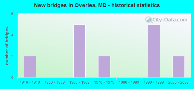
- New bridges - historical statistics
- 21940-1949
- 51960-1969
- 21970-1979
- 51990-1999
- 22000-2009
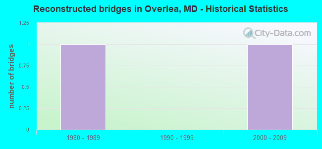
- Reconstructed bridges - Historical Statistics
- 11980-1989
- 01990-1999
- 12000-2009
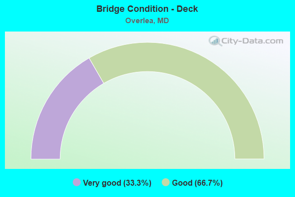
- Bridge Condition - Deck
- 33.3%Very good
- 66.7%Good
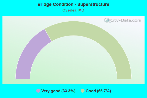
- Bridge Condition - Superstructure
- 33.3%Very good
- 66.7%Good

- Bridge Condition - Substructure
- 33.3%Very good
- 66.7%Good

- Bridge Condition - Channel
- 14.3%Good
- 42.9%Satisfactory
- 42.9%Fair
Find on map >> Show street view
Structure Number: 10000003000402, Location: 0.23 MILE SOUTH OF IS 695 (Lat: 39.367133, Lng: -76.516581), Route carried "on" structure: US 1, Year Built: 1960, Status: Open, Structure Length: 3.90m (12.80ft), Average Daily Traffic: 39,242 (year 2009), Truck Traffic: 8%, Average Future Daily Traffic: 45,719 (year 2026), Design Load: HS 20, Features Intersected: STEMMERS RUN
Minimum Vertical Clearance: 30+ m (98+ ft), Kilometerpoint: 27.009, Lanes on structure: 4, Base Highway Network: Yes, Owner: State Highway Agency, Approaching Roadway Width: 14.6m (47.9ft), Material/Design: Concrete, Design/Construction: Culvert, Length of Maximum Span: 3.7m (12.1ft)
Condition: Channel: Fair, Culverts: Satisfactory, Operating Rating: 32.7 metric tons, Method Used To Determine Operating Rating: Field evaluation and documented engineering judgment, Inventory Rating: 32.7 metric tons, Method Used To Determine Inventory Rating: Field evaluation and documented engineering judgment, Structural Evaluation: Equal to present minimum criteria, Waterway Adequacy: Equal to present minimum criteria, Approach Roadway Alignment: Equal to present desirable criteria, Designated Inspection Frequency: Every 24 months, Inspection Date: July 2020
Find on map >> Show street view
Structure Number: 10000003017501, Location: 3.0 MI N OF IS 95 (Lat: 39.369497, Lng: -76.513964), Route carried "on" structure: US 1, Year Built: 1995, Status: Open, Structure Length: 6.07m (19.91ft), Average Daily Traffic: 46,322 (year 2009), Truck Traffic: 8%, Average Future Daily Traffic: 53,940 (year 2026), Design Load: HS 25 or greater, Features Intersected: IS 695
Minimum Vertical Clearance: 30+ m (98+ ft), Kilometerpoint: 27.353, Lanes on structure: 6, Lanes under structure: 8, Base Highway Network: Yes, Owner: State Highway Agency, Approaching Roadway Width: 29.3m (96.1ft), Skew: 20 degrees, Material/Design: Steel continuous, Design/Construction: Stringer/Multi-beam, Number Of Spans In Main Unit: 2, Length of Maximum Span: 29.6m (97.1ft), Curb or Sidewalk Widths: Left: 1.6m (5.2ft), Right: 1.6m (5.2ft), Curb-To-Curb Width: 22.6m (74.1ft), Out-to-Out Width: 27.7m (90.9ft)
Condition: Deck: Good, Superstructure: Good, Substructure: Good, Inventory Rating: 71.7 metric tons, Method Used To Determine Inventory Rating: Load Factor (LF), Structural Evaluation: Better than present minimum criteria, Deck Geometry: Meets minimum limits, Underclear: Equal to present minimum criteria, Approach Roadway Alignment: Equal to present minimum criteria, Designated Inspection Frequency: Every 24 months, Inspection Date: May 2020, Deck Structure Type: Concrete Cast-file-Place, Wearing Surface/Protective System: Wearing Surface: Monolithic Concrete, Deck Protection: Epoxy Coated Reinforcing
Find on map >> Show street view
Structure Number: 10000003017601, Location: 0.62 MILE NORTH OF MD 588 (Lat: 39.360739, Lng: -76.505942), Route carried "on" structure: County highway 4457, Year Built: 2008, Status: Open, Structure Length: 9.94m (32.61ft), Average Daily Traffic: 13,000 (year 2008), Truck Traffic: 2%, Average Future Daily Traffic: 21,000 (year 2030), Design Load: HS 25 or greater, Features Intersected: IS 695, Facility Carried by Structure: LILLIAN HOLT DRIVE
Minimum Vertical Clearance: 30+ m (98+ ft), Kilometerpoint: 0.998, Lanes on structure: 4, Lanes under structure: 9, Owner: State Highway Agency, Approaching Roadway Width: 15.9m (52.2ft), Skew: 2 degrees, Material/Design: Steel continuous, Design/Construction: Stringer/Multi-beam, Number Of Spans In Main Unit: 2, Length of Maximum Span: 48.8m (160.1ft), Curb or Sidewalk Widths: Left: 1.7m (5.6ft), Right: 1.7m (5.6ft), Curb-To-Curb Width: 16.1m (52.8ft), Out-to-Out Width: 20.4m (66.9ft)
Condition: Deck: Very good, Superstructure: Very good, Substructure: Very good, Inventory Rating: 61.7 metric tons, Method Used To Determine Inventory Rating: Load Factor (LF), Structural Evaluation: Equal to present desirable criteria, Deck Geometry: Meets minimum limits, Underclear: Equal to present minimum criteria, Approach Roadway Alignment: Equal to present desirable criteria, Designated Inspection Frequency: Every 24 months, Inspection Date: March 2020, Deck Structure Type: Concrete Cast-file-Place, Wearing Surface/Protective System: Wearing Surface: Monolithic Concrete, Deck Protection: Epoxy Coated Reinforcing
Find on map >> Show street view
Structure Number: 10000003028703, Location: 0.24 MI N OF MD 43 (Lat: 39.381797, Lng: -76.500903), Route carried "on" structure: US 1, Year Built: 1971, Status: Open, Structure Length: 1.11m (3.64ft), Average Daily Traffic: 35,092 (year 2009), Truck Traffic: 8%, Average Future Daily Traffic: 38,755 (year 2026), Design Load: HS 20, Features Intersected: WHITEMARSH RUN
Minimum Vertical Clearance: 30+ m (98+ ft), Kilometerpoint: 29.107, Lanes on structure: 4, Base Highway Network: Yes, Owner: State Highway Agency, Approaching Roadway Width: 15.2m (49.9ft), Skew: 1 degrees, Material/Design: Steel, Design/Construction: Culvert, Length of Maximum Span: 3.0m (9.8ft)
Condition: Channel: Fair, Culverts: Satisfactory, Structural Evaluation: Equal to present minimum criteria, Waterway Adequacy: Equal to present desirable criteria, Approach Roadway Alignment: Equal to present desirable criteria, Designated Inspection Frequency: Every 24 months, Inspection Date: April 2020
Find on map >> Show street view
Structure Number: 10000003034401, Location: 0.85 MILE EAST OF IS 695 (Lat: 39.378817, Lng: -76.503717), Route carried "on" structure: US 1, Year Built: 1993, Status: Open, Structure Length: 6.00m (19.69ft), Average Daily Traffic: 35,092 (year 2009), Truck Traffic: 8%, Average Future Daily Traffic: 38,755 (year 2026), Design Load: HS 20, Features Intersected: MD 43
Minimum Vertical Clearance: 30+ m (98+ ft), Kilometerpoint: 28.721, Lanes on structure: 7, Lanes under structure: 5, Base Highway Network: Yes, Owner: State Highway Agency, Approaching Roadway Width: 27.1m (88.9ft), Skew: 20 degrees, Material/Design: Steel continuous, Design/Construction: Stringer/Multi-beam, Number Of Spans In Main Unit: 2, Length of Maximum Span: 29.3m (96.1ft), Curb or Sidewalk Widths: Left: 1.6m (5.2ft), Right: 1.6m (5.2ft), Curb-To-Curb Width: 26.4m (86.6ft), Out-to-Out Width: 31.5m (103.3ft)
Condition: Deck: Good, Superstructure: Good, Substructure: Good, Operating Rating: 68.9 metric tons, Method Used To Determine Operating Rating: Load Factor (LF), Inventory Rating: 41.3 metric tons, Method Used To Determine Inventory Rating: Load Factor (LF), Structural Evaluation: Better than present minimum criteria, Deck Geometry: Meets minimum limits, Underclear: High priority of corrective action, Approach Roadway Alignment: Equal to present desirable criteria, Designated Inspection Frequency: Every 24 months, Inspection Date: November 2020, Deck Structure Type: Concrete Cast-file-Place, Wearing Surface/Protective System: Wearing Surface: Monolithic Concrete, Deck Protection: Epoxy Coated Reinforcing
Find on map >> Show street view
Structure Number: 200000B-026802, Location: 0.79 MILES EAST OF US 1 (Lat: 39.348864, Lng: -76.522128), Route carried "on" structure: County highway 4303, Year Built: 1948, Year Reconstructed: 2009, Status: Open, Structure Length: 0.61m (2.00ft), Average Daily Traffic: 604 (year 2021), Truck Traffic: 10%, Average Future Daily Traffic: 1,511 (year 2041), Design Load: H 15, Features Intersected: REDHOUSE RUN, Facility Carried by Structure: RASPE AVENUE
Minimum Vertical Clearance: 30+ m (98+ ft), Kilometerpoint: 0.016, Lanes on structure: 2, Owner: County Highway Agency, Approaching Roadway Width: 7.3m (24.0ft), Material/Design: Concrete, Design/Construction: Culvert, Length of Maximum Span: 6.1m (20.0ft), Curb or Sidewalk Widths: Left: 2.4m (7.9ft), Right: 2.4m (7.9ft), Curb-To-Curb Width: 7.3m (24.0ft), Out-to-Out Width: 12.8m (42.0ft)
Condition: Channel: Satisfactory, Culverts: Satisfactory, Inventory Rating: 81.6 metric tons, Method Used To Determine Inventory Rating: Load Factor (LF), Structural Evaluation: Equal to present minimum criteria, Deck Geometry: Meets minimum limits, Waterway Adequacy: Better than present minimum criteria, Approach Roadway Alignment: Equal to present desirable criteria, Length Of Structure Improvement: 1.22m (4.00ft), Designated Inspection Frequency: Every 24 months, Inspection Date: July 2021, Bridge Improvement Cost: $840,000, Roadway Improvement Cost: $84,000, Total Project Cost: $924,000, Wearing Surface/Protective System: Wearing Surface: Bituminous
Find on map >> Show street view
Structure Number: 200000B-036402, Location: 0.2 MI E OF BELAIR RD (Lat: 39.370414, Lng: -76.507867), Route carried "on" structure: County highway 4207, Year Built: 1979, Status: Open, Structure Length: 0.76m (2.49ft), Average Daily Traffic: 2,721 (year 2018), Truck Traffic: 5%, Average Future Daily Traffic: 3,320 (year 2038), Design Load: HS 20, Features Intersected: STEMMERS RUN, Facility Carried by Structure: FITCH AVENUE
Minimum Vertical Clearance: 30+ m (98+ ft), Kilometerpoint: 0.998, Lanes on structure: 2, Owner: County Highway Agency, Approaching Roadway Width: 12.2m (40.0ft), Skew: 1 degrees, Material/Design: Concrete, Design/Construction: Culvert, Length of Maximum Span: 3.7m (12.1ft), Curb or Sidewalk Widths: Left: 1.5m (4.9ft), Right: 1.5m (4.9ft), Curb-To-Curb Width: 12.1m (39.7ft), Out-to-Out Width: 15.8m (51.8ft)
Condition: Channel: Fair, Culverts: Satisfactory, Operating Rating: 61.7 metric tons, Method Used To Determine Operating Rating: Load Factor (LF), Inventory Rating: 35.8 metric tons, Method Used To Determine Inventory Rating: Load Factor (LF), Structural Evaluation: Equal to present minimum criteria, Deck Geometry: Somewhat better than minimum adequacy, Waterway Adequacy: Better than present minimum criteria, Approach Roadway Alignment: Equal to present desirable criteria, Designated Inspection Frequency: Every 24 months, Inspection Date: July 2021
Find on map >> Show street view
Structure Number: 200000B-036802, Location: 300 FT W. OF ELLINWOOD RD (Lat: 39.335217, Lng: -76.512911), Route carried "on" structure: County highway 4394, Year Built: 1963, Status: Open, Structure Length: 1.62m (5.31ft), Average Daily Traffic: 4,505 (year 2021), Truck Traffic: 10%, Average Future Daily Traffic: 6,562 (year 2040), Design Load: HS 20, Features Intersected: REDHOUSE RUN, Facility Carried by Structure: WEYBURN ROAD
Minimum Vertical Clearance: 30+ m (98+ ft), Kilometerpoint: 0.837, Lanes on structure: 2, Owner: County Highway Agency, Approaching Roadway Width: 11.0m (36.1ft), Material/Design: Concrete, Design/Construction: Culvert, Length of Maximum Span: 5.2m (17.1ft), Curb or Sidewalk Widths: Left: 1.2m (3.9ft), Right: 1.2m (3.9ft)
Condition: Channel: Satisfactory, Culverts: Satisfactory, Inventory Rating: 66.2 metric tons, Method Used To Determine Inventory Rating: Load Factor (LF), Structural Evaluation: Equal to present minimum criteria, Waterway Adequacy: Better than present minimum criteria, Approach Roadway Alignment: Equal to present desirable criteria, Designated Inspection Frequency: Every 24 months, Inspection Date: August 2021
Find on map >> Show street view
Structure Number: 200000B-043703, Location: 0.2 MILES WEST OF IS 95 (Lat: 39.344556, Lng: -76.515806), Route carried "on" structure: County highway 6847, Year Built: 1990, Status: Open, Structure Length: 1.18m (3.87ft), Average Daily Traffic: 500 (year 2013), Truck Traffic: 5%, Average Future Daily Traffic: 1,254 (year 2039), Design Load: HS 20, Features Intersected: TRIBUTARY TO REDHOUSE CR, Facility Carried by Structure: TWILIGHT COURT
Minimum Vertical Clearance: 30+ m (98+ ft), Kilometerpoint: 0.000, Lanes on structure: 2, Owner: County Highway Agency, Approaching Roadway Width: 9.1m (29.9ft), Skew: 1 degrees, Material/Design: Steel, Design/Construction: Culvert, Length of Maximum Span: 11.6m (38.1ft)
Condition: Channel: Satisfactory, Culverts: Satisfactory, Operating Rating: 47.6 metric tons, Method Used To Determine Operating Rating: Load Factor (LF), Inventory Rating: 28.6 metric tons, Method Used To Determine Inventory Rating: Load Factor (LF), Structural Evaluation: Equal to present minimum criteria, Waterway Adequacy: Equal to present desirable criteria, Approach Roadway Alignment: Equal to present minimum criteria, Designated Inspection Frequency: Every 24 months, Inspection Date: July 2021
Find on map >> Show street view
Structure Number: 200000B-061902, Location: 1.0MI SW US1 AND I-695 (Lat: 39.588981, Lng: -76.874475), Route carried "on" structure: County highway , Year Built: 1948, Year Reconstructed: 1988, Status: Open, Structure Length: 1.28m (4.20ft), Average Daily Traffic: 12,981 (year 2001), Truck Traffic: 5%, Average Future Daily Traffic: 14,500 (year 2021), Design Load: HS 20, Features Intersected: TRIBUTARY TO REDHOUSE CR, Facility Carried by Structure: DANVILLE RD., DALE
Minimum Vertical Clearance: 30+ m (98+ ft), Kilometerpoint: 0.000, Lanes on structure: 2, Owner: County Highway Agency, Approaching Roadway Width: 7.3m (24.0ft), Skew: 4 degrees, Material/Design: Concrete, Design/Construction: Culvert, Length of Maximum Span: 7.0m (23.0ft)
Condition: Channel: Good, Culverts: Satisfactory, Operating Rating: 57.1 metric tons, Method Used To Determine Operating Rating: Load Factor (LF), Inventory Rating: 34.0 metric tons, Method Used To Determine Inventory Rating: Load Factor (LF), Structural Evaluation: Equal to present minimum criteria, Waterway Adequacy: Better than present minimum criteria, Approach Roadway Alignment: Better than present minimum criteria, Length Of Structure Improvement: 0.43m (1.41ft), Designated Inspection Frequency: Every 24 months, Inspection Date: Febuary 2021, Total Project Cost: $34,000
Find on map >> Show street view
Structure Number: 100000030173015, Location: 0.44 MI E OF MD 147 (Lat: 39.384650, Lng: -76.523864), Route carried "under" structure: County highway 3739, Year Built: 1993, Structure Length: 0. m, Average Daily Traffic: 4,572 (year 2012), Features Intersected: AVONDALE ROAD, Facility Carried by Structure: IS 695
Minimum Vertical Clearance: 4.27m (14.01ft), Kilometerpoint: 1.141, Lanes on structure: 6, Lanes under structure: 2, Material/Design: Steel, Design/Construction: Stringer/Multi-beam, Length of Maximum Span: 19.2m (63.0ft)
Find on map >> Show street view
Structure Number: 100000030173016, Location: 0.44 MI N OF MD 147 (Lat: 39.384811, Lng: -76.523433), Route carried "under" structure: County highway 3739, Year Built: 1961, Structure Length: 0. m, Average Daily Traffic: 4,572 (year 2012), Features Intersected: AVONDALE ROAD, Facility Carried by Structure: IS 695
Minimum Vertical Clearance: 4.27m (14.01ft), Kilometerpoint: 1.583, Lanes on structure: 3, Lanes under structure: 2, Material/Design: Steel, Design/Construction: Stringer/Multi-beam, Length of Maximum Span: 18.6m (61.0ft)
Find on map >> Show street view
Structure Number: 10000003017401, Location: 0.19 MILE NORTH OF MD 43 (Lat: 39.379508, Lng: -76.519256), Route carried "under" structure: Interstate 695, Year Built: 1961, Structure Length: 0. m, Average Daily Traffic: 133,222 (year 2009), Features Intersected: IS 695, Facility Carried by Structure: PUTTY HILL ROAD
Minimum Vertical Clearance: 4.88m (16.01ft), Kilometerpoint: 42.365, Lanes on structure: 2, Lanes under structure: 6, Material/Design: Steel, Design/Construction: Stringer/Multi-beam, Length of Maximum Span: 27.1m (88.9ft)
Find on map >> Show street view
Structure Number: 10000003017501, Location: 0.98 MILE NORTH OF MD 43 (Lat: 39.369497, Lng: -76.513964), Route carried "under" structure: Interstate 695, Year Built: 1961, Structure Length: 0. m, Average Daily Traffic: 145,162 (year 2009), Features Intersected: IS 695, Facility Carried by Structure: US 1
Minimum Vertical Clearance: 5.18m (16.99ft), Kilometerpoint: 43.636, Lanes on structure: 6, Lanes under structure: 8, Material/Design: Steel, Design/Construction: Stringer/Multi-beam, Length of Maximum Span: 25.3m (83.0ft)
Find on map >> Show street view
Structure Number: 10000003017601, Location: 0.79 MILE SOUTH OF IS 95 (Lat: 39.360739, Lng: -76.505942), Route carried "under" structure: Interstate 695, Year Built: 2008, Structure Length: 0. m, Average Daily Traffic: 145,162 (year 2009), Features Intersected: IS 695, Facility Carried by Structure: LILLIAN HOLT DRIVE
Minimum Vertical Clearance: 5.18m (16.99ft), Kilometerpoint: 44.859, Lanes on structure: 4, Lanes under structure: 6, Material/Design: Steel continuous, Design/Construction: Stringer/Multi-beam, Length of Maximum Span: 0.0m
Find on map >> Show street view
Structure Number: 10000003034401, Location: 0.97 MILE EAST OF IS 695 (Lat: 39.378817, Lng: -76.503717), Route carried "under" structure: State highway 43, Year Built: 1993, Structure Length: 0. m, Average Daily Traffic: 36,232 (year 2009), Truck Traffic: 8%, Features Intersected: MD 43, Facility Carried by Structure: US 1
Minimum Vertical Clearance: 5.49m (18.01ft), Kilometerpoint: 1.834, Lanes on structure: 7, Lanes under structure: 5, Material/Design: Steel continuous, Design/Construction: Stringer/Multi-beam, Length of Maximum Span: 29.3m (96.1ft)