Bridge Statistics for Olney, Maryland (MD)
Condition, Traffic, Stress, Structural Evaluation, Project Costs
- National Bridge Inventory (NBI) Statistics
- 19Number of bridges
- 233ft / 71.2mTotal length
- 276,822Total average daily traffic
- 10,224Total average daily truck traffic
- 425,742Total future (year 2026) average daily traffic
- National Bridge Inventory (NBI) Registered Bridges for Olney
- No street view available for this location
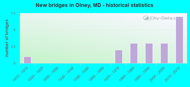
- New bridges - historical statistics
- 11910-1919
- 21970-1979
- 31980-1989
- 31990-1999
- 32000-2009
- 72010-2019


- Bridge Condition - Deck
- 87.5%Good
- 12.5%Satisfactory

- Bridge Condition - Superstructure
- 90.9%Good
- 9.1%Satisfactory

- Bridge Condition - Substructure
- 81.8%Good
- 9.1%Satisfactory
- 9.1%Fair

- Bridge Condition - Channel
- 6.3%Very good
- 62.5%Good
- 25.0%Satisfactory
- 6.3%Poor

- Bridge Condition - Culverts
- 25.0%Good
- 50.0%Satisfactory
- 25.0%Fair
Find on map >> Show street view
Structure Number: 10000015001601, Location: 0.29 M E OF GRIST MILL DR (Lat: 39.117683, Lng: -77.101353), Route carried "on" structure: State highway 115, Year Built: 1917, Year Reconstructed: 1970, Status: Open, Structure Length: 1.05m (3.44ft), Average Daily Traffic: 16,981 (year 2013), Truck Traffic: 8%, Average Future Daily Traffic: 21,803 (year 2026), Design Load: HS 20, Features Intersected: NORTH BR OF ROCK CREEK
Minimum Vertical Clearance: 30+ m (98+ ft), Kilometerpoint: 7.247, Lanes on structure: 2, Owner: State Highway Agency, Approaching Roadway Width: 13.4m (44.0ft), Skew: 2 degrees, Material/Design: Concrete, Design/Construction: Arch - Deck, Number Of Spans In Main Unit: 1, Length of Maximum Span: 9.1m (29.9ft), Curb-To-Curb Width: 13.4m (44.0ft), Out-to-Out Width: 14.3m (46.9ft)
Condition: Deck: Satisfactory, Superstructure: Satisfactory, Substructure: Fair, Channel: Good, Inventory Rating: 58.5 metric tons, Method Used To Determine Inventory Rating: Load Factor (LF), Structural Evaluation: Somewhat better than minimum adequacy, Deck Geometry: Equal to present minimum criteria, Waterway Adequacy: Superior to present desirable criteria, Approach Roadway Alignment: Equal to present desirable criteria, Designated Inspection Frequency: Every 24 months, Inspection Date: May 2020, Deck Structure Type: Concrete Cast-file-Place, Wearing Surface/Protective System: Wearing Surface: Bituminous, Membrane: Other
Find on map >> Show street view
Structure Number: 10000015006501, Location: 0.65 MILE WEST OF MD 182 (Lat: 39.119544, Lng: -77.045433), Route carried "on" structure: State highway 28, Year Built: 1999, Status: Open, Structure Length: 1.01m (3.31ft), Average Daily Traffic: 24,340 (year 2009), Truck Traffic: 4%, Average Future Daily Traffic: 26,692 (year 2026), Design Load: HS 25 or greater, Features Intersected: BATCHELLORS RUN
Minimum Vertical Clearance: 30+ m (98+ ft), Kilometerpoint: 47.031, Lanes on structure: 2, Base Highway Network: Yes, Owner: State Highway Agency, Approaching Roadway Width: 21.9m (71.9ft), Material/Design: Concrete, Design/Construction: Culvert, Number Of Spans In Main Unit: 3, Length of Maximum Span: 3.0m (9.8ft), Curb or Sidewalk Widths: Left: 0.5m (1.6ft), Right: 0.5m (1.6ft), Curb-To-Curb Width: 14.7m (48.2ft), Out-to-Out Width: 15.6m (51.2ft)
Condition: Channel: Good, Culverts: Good, Operating Rating: 43.5 metric tons, Method Used To Determine Operating Rating: Field evaluation and documented engineering judgment, Inventory Rating: 43.5 metric tons, Method Used To Determine Inventory Rating: Field evaluation and documented engineering judgment, Structural Evaluation: Better than present minimum criteria, Deck Geometry: Superior to present desirable criteria, Waterway Adequacy: Superior to present desirable criteria, Approach Roadway Alignment: Equal to present desirable criteria, Designated Inspection Frequency: Every 24 months, Inspection Date: August 2020, Wearing Surface/Protective System: Wearing Surface: Bituminous
Find on map >> Show street view
Structure Number: 10000015016403, Location: 1.24 MILES EAST OF MD 97 (Lat: 39.147839, Lng: -77.053317), Route carried "on" structure: State highway 108, Year Built: 1994, Status: Open, Structure Length: 1.04m (3.41ft), Average Daily Traffic: 22,100 (year 2018), Truck Traffic: 4%, Average Future Daily Traffic: 22,140 (year 2038), Design Load: HS 20, Features Intersected: TRIB TO JAMES CREEK
Minimum Vertical Clearance: 30+ m (98+ ft), Kilometerpoint: 22.782, Lanes on structure: 4, Base Highway Network: Yes, Owner: State Highway Agency, Approaching Roadway Width: 21.9m (71.9ft), Skew: 26 degrees, Material/Design: Steel, Design/Construction: Culvert, Number Of Spans In Main Unit: 3, Length of Maximum Span: 2.7m (8.9ft), Curb or Sidewalk Widths: Left: 2.4m (7.9ft), Right: 2.4m (7.9ft)
Condition: Channel: Good, Culverts: Good, Structural Evaluation: Better than present minimum criteria, Waterway Adequacy: Better than present minimum criteria, Approach Roadway Alignment: Equal to present desirable criteria, Designated Inspection Frequency: Every 24 months, Inspection Date: September 2020
Find on map >> Show street view
Structure Number: 200000M-007002, Location: 0.9 MI S OF BOWIE MILL RD (Lat: 39.143797, Lng: -77.092419), Route carried "on" structure: County highway 136, Year Built: 1972, Status: Open, Structure Length: 0.82m (2.69ft), Average Daily Traffic: 6,001 (year 2019), Truck Traffic: 5%, Average Future Daily Traffic: 7,329 (year 2039), Design Load: HS 20, Features Intersected: WILLIAMSBURG RUN, Facility Carried by Structure: CASHELL ROAD
Minimum Vertical Clearance: 30+ m (98+ ft), Kilometerpoint: 2.317, Lanes on structure: 2, Base Highway Network: Yes, Owner: County Highway Agency, Approaching Roadway Width: 7.3m (24.0ft), Material/Design: Concrete, Design/Construction: Culvert, Length of Maximum Span: 3.7m (12.1ft)
Condition: Channel: Satisfactory, Culverts: Satisfactory, Operating Rating: 77.5 metric tons, Method Used To Determine Operating Rating: Load Factor (LF), Inventory Rating: 46.3 metric tons, Method Used To Determine Inventory Rating: Load Factor (LF), Structural Evaluation: Equal to present minimum criteria, Waterway Adequacy: Better than present minimum criteria, Approach Roadway Alignment: Equal to present minimum criteria, Designated Inspection Frequency: Every 24 months, Inspection Date: October 2020
Find on map >> Show street view
Structure Number: 200000M-025901, Location: N OF BOWIE MILL ROAD (Lat: 39.158706, Lng: -77.094839), Route carried "on" structure: County highway 6091, Year Built: 2002, Status: Open, Structure Length: 0.94m (3.08ft), Average Daily Traffic: 684 (year 2019), Truck Traffic: 5%, Average Future Daily Traffic: 829 (year 2039), Design Load: HS 20, Features Intersected: ROCK CRK NORTH BRANCH TR, Facility Carried by Structure: WICKHAM ROAD
Minimum Vertical Clearance: 30+ m (98+ ft), Kilometerpoint: 0.000, Lanes on structure: 2, Owner: County Highway Agency, Approaching Roadway Width: 7.9m (25.9ft), Skew: 1 degrees, Material/Design: Steel, Design/Construction: Arch - Deck, Number Of Spans In Main Unit: 1, Length of Maximum Span: 9.1m (29.9ft), Curb or Sidewalk Widths: Left: 0.3m (1.0ft), Right: 0.3m (1.0ft), Curb-To-Curb Width: 7.3m (24.0ft), Out-to-Out Width: 7.9m (25.9ft)
Condition: Superstructure: Good, Substructure: Good, Channel: Satisfactory, Structural Evaluation: Better than present minimum criteria, Deck Geometry: Meets minimum limits, Waterway Adequacy: Better than present minimum criteria, Approach Roadway Alignment: Equal to present desirable criteria, Length Of Structure Improvement: 3.20m (10.50ft), Designated Inspection Frequency: Every 24 months, Inspection Date: August 2021
Find on map >> Show street view
Structure Number: 200000M-026001, Location: N OF BOWIE MILL ROAD (Lat: 39.162758, Lng: -77.100350), Route carried "on" structure: County highway 6091, Year Built: 2002, Status: Open, Structure Length: 0.68m (2.23ft), Average Daily Traffic: 376 (year 2019), Truck Traffic: 5%, Average Future Daily Traffic: 508 (year 2039), Design Load: HS 20, Features Intersected: TRIB. TO ROCK CREEK N. B, Facility Carried by Structure: WICKHAM ROAD
Minimum Vertical Clearance: 30+ m (98+ ft), Kilometerpoint: 0.000, Lanes on structure: 2, Owner: County Highway Agency, Approaching Roadway Width: 7.9m (25.9ft), Material/Design: Steel, Design/Construction: Arch - Deck, Number Of Spans In Main Unit: 1, Length of Maximum Span: 6.7m (22.0ft), Curb or Sidewalk Widths: Left: 0.3m (1.0ft), Right: 0.3m (1.0ft), Curb-To-Curb Width: 7.3m (24.0ft), Out-to-Out Width: 7.9m (25.9ft)
Condition: Superstructure: Good, Substructure: Good, Channel: Good, Structural Evaluation: Better than present minimum criteria, Deck Geometry: Somewhat better than minimum adequacy, Waterway Adequacy: Better than present minimum criteria, Approach Roadway Alignment: Equal to present desirable criteria, Designated Inspection Frequency: Every 24 months, Inspection Date: August 2021
Find on map >> Show street view
Structure Number: 200000M-026101, Location: N OF BOWIE MILL ROAD (Lat: 39.161383, Lng: -77.100353), Route carried "on" structure: County highway 7582, Year Built: 2002, Status: Open, Structure Length: 0.92m (3.02ft), Average Daily Traffic: 64 (year 2019), Truck Traffic: 5%, Average Future Daily Traffic: 96 (year 2039), Design Load: HS 20, Features Intersected: ROCK CRK NORTH BRANCH TR, Facility Carried by Structure: TACKBROOKE DRIVE
Minimum Vertical Clearance: 30+ m (98+ ft), Kilometerpoint: 0.000, Lanes on structure: 2, Owner: County Highway Agency, Approaching Roadway Width: 7.9m (25.9ft), Skew: 1 degrees, Material/Design: Steel, Design/Construction: Arch - Deck, Number Of Spans In Main Unit: 1, Length of Maximum Span: 8.8m (28.9ft), Curb or Sidewalk Widths: Left: 1.2m (3.9ft), Right: 1.2m (3.9ft), Curb-To-Curb Width: 7.3m (24.0ft), Out-to-Out Width: 7.9m (25.9ft)
Condition: Superstructure: Good, Substructure: Satisfactory, Channel: Good, Inventory Rating: 62.1 metric tons, Method Used To Determine Inventory Rating: Load Factor (LF), Structural Evaluation: Equal to present minimum criteria, Deck Geometry: Equal to present minimum criteria, Waterway Adequacy: Better than present minimum criteria, Approach Roadway Alignment: Equal to present minimum criteria, Designated Inspection Frequency: Every 24 months, Inspection Date: August 2021
Find on map >> Show street view
Structure Number: 200000M-028503, Location: .1 MI N OF MD-108 (Lat: 39.153225, Lng: -77.060547), Route carried "on" structure: City street 4297, Year Built: 1990, Status: Open, Structure Length: 0.73m (2.40ft), Average Daily Traffic: 6,148 (year 2021), Truck Traffic: 5%, Average Future Daily Traffic: 7,311 (year 2041), Features Intersected: TRIBUTARY TO JAMES CREEK, Facility Carried by Structure: SPARTAN ROAD
Minimum Vertical Clearance: 30+ m (98+ ft), Kilometerpoint: 0.000, Lanes on structure: 2, Owner: County Highway Agency, Approaching Roadway Width: 12.2m (40.0ft), Skew: 6 degrees, Material/Design: Steel, Design/Construction: Culvert, Length of Maximum Span: 3.7m (12.1ft), Curb or Sidewalk Widths: Left: 1.2m (3.9ft), Right: 1.2m (3.9ft)
Condition: Channel: Good, Culverts: Fair, Structural Evaluation: Somewhat better than minimum adequacy, Waterway Adequacy: Better than present minimum criteria, Approach Roadway Alignment: Equal to present desirable criteria, Designated Inspection Frequency: Every 24 months, Inspection Date: November 2021
Find on map >> Show street view
Structure Number: 200000M-028703, Location: 0.5 MI N OF MD 108 (Lat: 39.154011, Lng: -77.052183), Route carried "on" structure: City street 132, Year Built: 1985, Status: Open, Structure Length: 0.63m (2.07ft), Average Daily Traffic: 10,285 (year 2021), Truck Traffic: 4%, Average Future Daily Traffic: 12,230 (year 2041), Features Intersected: TRIBUTARY TO JAMES CREEK, Facility Carried by Structure: OLD BALTIMORE ROAD
Minimum Vertical Clearance: 30+ m (98+ ft), Kilometerpoint: 0.000, Lanes on structure: 2, Owner: County Highway Agency, Approaching Roadway Width: 11.0m (36.1ft), Skew: 2 degrees, Material/Design: Steel, Design/Construction: Culvert, Length of Maximum Span: 2.4m (7.9ft), Curb or Sidewalk Widths: Left: 1.2m (3.9ft), Right: 1.2m (3.9ft)
Condition: Channel: Good, Culverts: Satisfactory, Structural Evaluation: Equal to present minimum criteria, Waterway Adequacy: Better than present minimum criteria, Approach Roadway Alignment: Equal to present desirable criteria, Designated Inspection Frequency: Every 24 months, Inspection Date: November 2021
Find on map >> Show street view
Structure Number: 200000M-036402, Location: 0.2 MI. S. OF MD 108 (Lat: 39.145183, Lng: -77.053567), Route carried "on" structure: City street , Year Built: 1988, Status: Open, Structure Length: 0.90m (2.95ft), Average Daily Traffic: 520 (year 2018), Truck Traffic: 5%, Average Future Daily Traffic: 625 (year 2038), Features Intersected: TRIBUTARY TO JAMES CREEK, Facility Carried by Structure: BRIMSTONE ACADEMY
Minimum Vertical Clearance: 30+ m (98+ ft), Kilometerpoint: 0.000, Lanes on structure: 2, Owner: County Highway Agency, Approaching Roadway Width: 14.0m (45.9ft), Skew: 4 degrees, Material/Design: Concrete, Design/Construction: Culvert, Length of Maximum Span: 3.0m (9.8ft), Curb or Sidewalk Widths: Left: 0.0m, Right: 1.2m (3.9ft)
Condition: Channel: Good, Culverts: Satisfactory, Operating Rating: 32.7 metric tons, Method Used To Determine Operating Rating: Field evaluation and documented engineering judgment, Inventory Rating: 32.7 metric tons, Method Used To Determine Inventory Rating: Field evaluation and documented engineering judgment, Structural Evaluation: Equal to present minimum criteria, Waterway Adequacy: Better than present minimum criteria, Approach Roadway Alignment: Equal to present desirable criteria, Designated Inspection Frequency: Every 24 months, Inspection Date: January 2020
Find on map >> Show street view
Structure Number: 200000M-039703, Location: .5 MI NORTH OF MD-200 (Lat: 39.130544, Lng: -77.088125), Route carried "on" structure: County highway 3896, Year Built: 1973, Status: Open, Structure Length: 0.86m (2.82ft), Average Daily Traffic: 500 (year 2018), Truck Traffic: 2%, Average Future Daily Traffic: 625 (year 2040), Features Intersected: TRIBUTARY TO NORTH BRANC, Facility Carried by Structure: GEORGE WASHINGTON
Minimum Vertical Clearance: 30+ m (98+ ft), Kilometerpoint: 0.000, Lanes on structure: 2, Owner: County Highway Agency, Approaching Roadway Width: 6.7m (22.0ft), Skew: 3 degrees, Material/Design: Steel, Design/Construction: Culvert, Length of Maximum Span: 3.0m (9.8ft)
Condition: Channel: Satisfactory, Culverts: Satisfactory, Operating Rating: 66.7 metric tons, Method Used To Determine Operating Rating: Load Factor (LF), Inventory Rating: 39.9 metric tons, Method Used To Determine Inventory Rating: Load Factor (LF), Structural Evaluation: Equal to present minimum criteria, Waterway Adequacy: Better than present minimum criteria, Approach Roadway Alignment: Equal to present desirable criteria, Designated Inspection Frequency: Every 24 months, Inspection Date: January 2020
Find on map >> Show street view
Structure Number: 200000M-046703, Location: 0.90 MI. W. OF MD 108 (Lat: 39.151711, Lng: -77.088892), Route carried "on" structure: County highway 4012, Year Built: 1980, Status: Open, Structure Length: 1.14m (3.74ft), Average Daily Traffic: 4,854 (year 2016), Truck Traffic: 2%, Average Future Daily Traffic: 7,504 (year 2038), Features Intersected: WILLIAMSBURG RUN TRIB, Facility Carried by Structure: MORNINGWOOD DRIVE
Minimum Vertical Clearance: 30+ m (98+ ft), Kilometerpoint: 0.000, Lanes on structure: 2, Owner: County Highway Agency, Approaching Roadway Width: 10.4m (34.1ft), Material/Design: Steel, Design/Construction: Culvert, Length of Maximum Span: 2.1m (6.9ft), Curb or Sidewalk Widths: Left: 0.2m (0.7ft), Right: 0.2m (0.7ft)
Condition: Channel: Poor, Culverts: Fair, Inventory Rating: 72.6 metric tons, Method Used To Determine Inventory Rating: Load Factor (LF), Structural Evaluation: Somewhat better than minimum adequacy, Waterway Adequacy: Better than present minimum criteria, Approach Roadway Alignment: Equal to present desirable criteria, Designated Inspection Frequency: Every 24 months, Inspection Date: January 2020
Find on map >> Show street view
Structure Number: 300000M-V067013, Location: 1.51 MI W OF MD 97 (Lat: 39.125989, Lng: -77.101500), Route carried "on" structure: State highway 200, Year Built: 2010, Status: Open, Structure Length: 8.87m (29.10ft), Average Daily Traffic: 31,652 (year 2019), Truck Traffic: 4%, Average Future Daily Traffic: 61,957 (year 2041), Design Load: HS 25 or greater, Features Intersected: NORTH BRANCH ROCK CREEK
Minimum Vertical Clearance: 30+ m (98+ ft), Kilometerpoint: 1.076, Lanes on structure: 3, Base Highway Network: Yes, Toll: On toll road, Owner: State Toll Authority, Approaching Roadway Width: 17.1m (56.1ft), Skew: 12 degrees, Material/Design: Prestressed concrete continuous, Design/Construction: Stringer/Multi-beam, Number Of Spans In Main Unit: 2, Length of Maximum Span: 47.2m (154.9ft), Curb or Sidewalk Widths: Left: 0.0m, Right: 0.3m (1.0ft), Curb-To-Curb Width: 1.7m (5.6ft), Out-to-Out Width: 21.8m (71.5ft)
Condition: Deck: Good, Superstructure: Good, Substructure: Good, Channel: Satisfactory, Operating Rating: 71.7 metric tons, Method Used To Determine Operating Rating: Load Factor (LF), Inventory Rating: 37.6 metric tons, Method Used To Determine Inventory Rating: Load Factor (LF), Structural Evaluation: Better than present minimum criteria, Deck Geometry: High priority of replacement, Waterway Adequacy: Superior to present desirable criteria, Approach Roadway Alignment: Equal to present desirable criteria, Designated Inspection Frequency: Every 24 months, Inspection Date: December 2021, Deck Structure Type: Concrete Cast-file-Place, Wearing Surface/Protective System: Wearing Surface: Monolithic Concrete, Deck Protection: Epoxy Coated Reinforcing
Find on map >> Show street view
Structure Number: 300000M-V067014, Location: 1.51 MI W OF MD 97 (Lat: 39.126128, Lng: -77.100189), Route carried "on" structure: State highway 200, Year Built: 2010, Status: Open, Structure Length: 8.87m (29.10ft), Average Daily Traffic: 30,827 (year 2019), Truck Traffic: 3%, Average Future Daily Traffic: 60,342 (year 2041), Design Load: HS 25 or greater, Features Intersected: NORTH BRANCH ROCK CREEK
Minimum Vertical Clearance: 30+ m (98+ ft), Kilometerpoint: 1.076, Lanes on structure: 3, Base Highway Network: Yes, Toll: On toll road, Owner: State Toll Authority, Approaching Roadway Width: 17.1m (56.1ft), Skew: 12 degrees, Material/Design: Prestressed concrete continuous, Design/Construction: Stringer/Multi-beam, Number Of Spans In Main Unit: 2, Length of Maximum Span: 47.2m (154.9ft), Curb-To-Curb Width: 17.1m (56.1ft), Out-to-Out Width: 18.2m (59.7ft)
Condition: Deck: Good, Superstructure: Good, Substructure: Good, Channel: Good, Operating Rating: 73.9 metric tons, Method Used To Determine Operating Rating: Load Factor (LF), Inventory Rating: 44.0 metric tons, Method Used To Determine Inventory Rating: Load Factor (LF), Structural Evaluation: Better than present minimum criteria, Deck Geometry: Equal to present minimum criteria, Waterway Adequacy: Superior to present desirable criteria, Approach Roadway Alignment: Equal to present desirable criteria, Designated Inspection Frequency: Every 24 months, Inspection Date: December 2021, Deck Structure Type: Concrete Cast-file-Place, Wearing Surface/Protective System: Wearing Surface: Monolithic Concrete, Deck Protection: Epoxy Coated Reinforcing
Find on map >> Show street view
Structure Number: 300000M-V069013, Location: 1.34 MI W OF MD 97 (Lat: 39.125561, Lng: -77.097967), Route carried "on" structure: State highway 200, Year Built: 2010, Status: Open, Structure Length: 9.08m (29.79ft), Average Daily Traffic: 31,652 (year 2019), Truck Traffic: 4%, Average Future Daily Traffic: 61,957 (year 2041), Design Load: HS 25 or greater, Features Intersected: TRIBUTARY OF NBRC
Minimum Vertical Clearance: 30+ m (98+ ft), Kilometerpoint: 1.104, Lanes on structure: 3, Base Highway Network: Yes, Toll: On toll road, Owner: State Toll Authority, Approaching Roadway Width: 17.1m (56.1ft), Skew: 15 degrees, Material/Design: Prestressed concrete continuous, Design/Construction: Stringer/Multi-beam, Number Of Spans In Main Unit: 2, Length of Maximum Span: 43.9m (144.0ft), Curb or Sidewalk Widths: Left: 0.0m, Right: 0.3m (1.0ft), Curb-To-Curb Width: 17.1m (56.1ft), Out-to-Out Width: 21.8m (71.5ft)
Condition: Deck: Good, Superstructure: Good, Substructure: Good, Channel: Very good, Operating Rating: 78.5 metric tons, Method Used To Determine Operating Rating: Load Factor (LF), Inventory Rating: 39.5 metric tons, Method Used To Determine Inventory Rating: Load Factor (LF), Structural Evaluation: Better than present minimum criteria, Deck Geometry: Equal to present minimum criteria, Waterway Adequacy: Equal to present desirable criteria, Approach Roadway Alignment: Equal to present desirable criteria, Designated Inspection Frequency: Every 24 months, Inspection Date: November 2021, Deck Structure Type: Concrete Cast-file-Place, Wearing Surface/Protective System: Wearing Surface: Monolithic Concrete, Deck Protection: Epoxy Coated Reinforcing
Find on map >> Show street view
Structure Number: 300000M-V069014, Location: 1.34 MI W OF MD 97 (Lat: 39.125850, Lng: -77.098297), Route carried "on" structure: State highway 200, Year Built: 2010, Status: Open, Structure Length: 9.08m (29.79ft), Average Daily Traffic: 30,827 (year 2019), Truck Traffic: 3%, Average Future Daily Traffic: 60,342 (year 2041), Design Load: HS 25 or greater, Features Intersected: TRIBUTARY OF NBRC
Minimum Vertical Clearance: 30+ m (98+ ft), Kilometerpoint: 1.104, Lanes on structure: 3, Base Highway Network: Yes, Owner: State Toll Authority, Approaching Roadway Width: 17.1m (56.1ft), Skew: 15 degrees, Material/Design: Prestressed concrete continuous, Design/Construction: Stringer/Multi-beam, Number Of Spans In Main Unit: 2, Length of Maximum Span: 43.9m (144.0ft), Curb-To-Curb Width: 17.1m (56.1ft), Out-to-Out Width: 18.4m (60.4ft)
Condition: Deck: Good, Superstructure: Good, Substructure: Good, Channel: Good, Operating Rating: 72.6 metric tons, Method Used To Determine Operating Rating: Load Factor (LF), Inventory Rating: 41.7 metric tons, Method Used To Determine Inventory Rating: Load Factor (LF), Structural Evaluation: Better than present minimum criteria, Deck Geometry: Equal to present minimum criteria, Waterway Adequacy: Superior to present desirable criteria, Approach Roadway Alignment: Equal to present desirable criteria, Designated Inspection Frequency: Every 24 months, Inspection Date: November 2021, Deck Structure Type: Concrete Cast-file-Place, Wearing Surface/Protective System: Wearing Surface: Monolithic Concrete, Deck Protection: Epoxy Coated Reinforcing
Find on map >> Show street view
Structure Number: 300000M-V07301, Location: 0.93 MI W OF MD 97 (Lat: 39.123764, Lng: -77.090858), Route carried "on" structure: County highway 137, Year Built: 2010, Status: Open, Structure Length: 8.93m (29.30ft), Average Daily Traffic: 8,133 (year 2019), Truck Traffic: 5%, Average Future Daily Traffic: 10,123 (year 2041), Design Load: HS 25 or greater, Features Intersected: MD 200 (ICC), Facility Carried by Structure: EMORY LANE
Minimum Vertical Clearance: 30+ m (98+ ft), Kilometerpoint: 1.170, Lanes on structure: 2, Lanes under structure: 6, Owner: State Toll Authority, Approaching Roadway Width: 9.8m (32.2ft), Skew: 3 degrees, Material/Design: Steel continuous, Design/Construction: Stringer/Multi-beam, Number Of Spans In Main Unit: 2, Length of Maximum Span: 43.9m (144.0ft), Curb or Sidewalk Widths: Left: 1.7m (5.6ft), Right: 0.3m (1.0ft), Curb-To-Curb Width: 9.8m (32.2ft), Out-to-Out Width: 15.6m (51.2ft)
Condition: Deck: Good, Superstructure: Good, Substructure: Good, Operating Rating: 69.4 metric tons, Method Used To Determine Operating Rating: Load Factor (LF), Inventory Rating: 41.7 metric tons, Method Used To Determine Inventory Rating: Load Factor (LF), Structural Evaluation: Better than present minimum criteria, Deck Geometry: Meets minimum limits, Underclear: High priority of corrective action, Approach Roadway Alignment: Equal to present desirable criteria, Designated Inspection Frequency: Every 24 months, Inspection Date: November 2021, Deck Structure Type: Concrete Cast-file-Place, Wearing Surface/Protective System: Wearing Surface: Monolithic Concrete, Deck Protection: Epoxy Coated Reinforcing
Find on map >> Show street view
Structure Number: 300000M-V082011, Location: 0.59 MI NORTH OF MD 28 (Lat: 39.117903, Lng: -77.074642), Route carried "on" structure: State highway 97, Year Built: 2010, Status: Open, Structure Length: 7.80m (25.59ft), Average Daily Traffic: 23,218 (year 2019), Truck Traffic: 2%, Average Future Daily Traffic: 28,900 (year 2041), Design Load: HS 25 or greater, Features Intersected: MD 200 (ICC)
Minimum Vertical Clearance: 30+ m (98+ ft), Kilometerpoint: 1.319, Lanes on structure: 5, Lanes under structure: 6, Owner: State Toll Authority, Approaching Roadway Width: 20.4m (66.9ft), Skew: 10 degrees, Material/Design: Steel continuous, Design/Construction: Stringer/Multi-beam, Number Of Spans In Main Unit: 2, Length of Maximum Span: 39.0m (128.0ft), Curb or Sidewalk Widths: Left: 0.0m, Right: 1.7m (5.6ft), Curb-To-Curb Width: 20.4m (66.9ft), Out-to-Out Width: 23.3m (76.4ft)
Condition: Deck: Good, Superstructure: Good, Substructure: Good, Operating Rating: 84.4 metric tons, Method Used To Determine Operating Rating: Load Factor (LF), Inventory Rating: 50.3 metric tons, Method Used To Determine Inventory Rating: Load Factor (LF), Structural Evaluation: Better than present minimum criteria, Deck Geometry: Somewhat better than minimum adequacy, Underclear: High priority of corrective action, Approach Roadway Alignment: Equal to present desirable criteria, Designated Inspection Frequency: Every 24 months, Inspection Date: November 2021, Deck Structure Type: Concrete Cast-file-Place, Wearing Surface/Protective System: Wearing Surface: Monolithic Concrete, Deck Protection: Epoxy Coated Reinforcing
Find on map >> Show street view
Structure Number: 300000M-V082012, Location: 0.59 MI NORTH OF MD 28 (Lat: 39.117953, Lng: -77.075022), Route carried "on" structure: State highway 97, Year Built: 2010, Status: Open, Structure Length: 7.80m (25.59ft), Average Daily Traffic: 27,660 (year 2019), Truck Traffic: 2%, Average Future Daily Traffic: 34,429 (year 2041), Design Load: HS 25 or greater, Features Intersected: MD 200 (ICC)
Minimum Vertical Clearance: 30+ m (98+ ft), Kilometerpoint: 1.319, Lanes on structure: 3, Lanes under structure: 6, Owner: State Toll Authority, Approaching Roadway Width: 13.7m (44.9ft), Skew: 10 degrees, Material/Design: Steel continuous, Design/Construction: Stringer/Multi-beam, Number Of Spans In Main Unit: 2, Length of Maximum Span: 39.0m (128.0ft), Curb or Sidewalk Widths: Left: 0.3m (1.0ft), Right: 0.0m, Curb-To-Curb Width: 13.7m (44.9ft), Out-to-Out Width: 17.9m (58.7ft)
Condition: Deck: Good, Superstructure: Good, Substructure: Good, Operating Rating: 73.5 metric tons, Method Used To Determine Operating Rating: Load Factor (LF), Inventory Rating: 44.0 metric tons, Method Used To Determine Inventory Rating: Load Factor (LF), Structural Evaluation: Better than present minimum criteria, Deck Geometry: Somewhat better than minimum adequacy, Underclear: High priority of corrective action, Approach Roadway Alignment: Equal to present desirable criteria, Designated Inspection Frequency: Every 24 months, Inspection Date: November 2021, Deck Structure Type: Concrete Cast-file-Place, Wearing Surface/Protective System: Wearing Surface: Monolithic Concrete, Deck Protection: Epoxy Coated Reinforcing