Bridge Statistics for Old Bridge, New Jersey (NJ)
Condition, Traffic, Stress, Structural Evaluation, Project Costs
- National Bridge Inventory (NBI) Statistics
- 24Number of bridges
- 200ft / 61.2mTotal length
- $2,005,000Total costs
- 567,889Total average daily traffic
- 22,453Total average daily truck traffic
- National Bridge Inventory (NBI) Registered Bridges for Old Bridge
- No street view available for this location
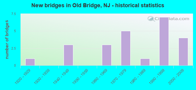
- New bridges - historical statistics
- 11920-1929
- 31940-1949
- 31960-1969
- 51970-1979
- 11980-1989
- 71990-1999
- 42000-2009

- Reconstructed bridges - Historical Statistics
- 21960-1969
- 01970-1979
- 01980-1989
- 01990-1999
- 12000-2009
- 12010-2019


- Bridge Condition - Deck
- 50.0%Good
- 28.6%Satisfactory
- 14.3%Fair
- 7.1%Poor

- Bridge Condition - Superstructure
- 14.3%Very good
- 42.9%Good
- 14.3%Satisfactory
- 28.6%Fair

- Bridge Condition - Substructure
- 7.1%Very good
- 64.3%Good
- 21.4%Satisfactory
- 7.1%Fair

- Bridge Condition - Channel
- 15.4%Very good
- 23.1%Good
- 46.2%Satisfactory
- 15.4%Fair

- Bridge Condition - Culverts
- 75.0%Satisfactory
- 25.0%Fair
Find on map >> Show street view
Structure Number: 1206151, Location: 1.1 MILES NO. OF RT. 18 (Lat: 40.385000, Lng: -74.308331), Route carried "on" structure: US 9, Year Built: 1940, Year Reconstructed: 1973, Status: Open, Structure Length: 1.07m (3.51ft), Average Daily Traffic: 65,012 (year 2019), Truck Traffic: 4%, Average Future Daily Traffic: 79,405 (year 2039), Design Load: HS 20, Features Intersected: DEEP RUN BROOK
Minimum Vertical Clearance: 30+ m (98+ ft), Kilometerpoint: 198.303, Lanes on structure: 7, Base Highway Network: Yes, Owner: State Highway Agency, Approaching Roadway Width: 35.1m (115.2ft), Skew: 21 degrees, Material/Design: Steel, Design/Construction: Stringer/Multi-beam, Number Of Spans In Main Unit: 1, Length of Maximum Span: 9.4m (30.8ft), Curb or Sidewalk Widths: Left: 3.0m (9.8ft), Right: 3.0m (9.8ft), Curb-To-Curb Width: 35.2m (115.5ft), Out-to-Out Width: 46.9m (153.9ft)
Condition: Deck: Satisfactory, Superstructure: Satisfactory, Substructure: Satisfactory, Channel: Satisfactory, Operating Rating: 66.2 metric tons, Method Used To Determine Operating Rating: Load Factor (LF), Inventory Rating: 33.6 metric tons, Method Used To Determine Inventory Rating: Load Factor (LF), Structural Evaluation: Equal to present minimum criteria, Deck Geometry: Superior to present desirable criteria, Waterway Adequacy: Superior to present desirable criteria, Approach Roadway Alignment: Equal to present desirable criteria, Designated Inspection Frequency: Every 24 months, Inspection Date: July 2021, Total Project Cost: $164,000 ( Estimate for 2019), Deck Structure Type: Concrete Cast-file-Place, Wearing Surface/Protective System: Wearing Surface: Bituminous
Find on map >> Show street view
Structure Number: 1206153, Location: 2.28 MI NORTH OF RT 18 (Lat: 40.401669, Lng: -74.306669), Route carried "on" structure: US 9, Year Built: 1941, Year Reconstructed: 1973, Status: Open, Structure Length: 2.50m (8.20ft), Average Daily Traffic: 76,510 (year 2021), Truck Traffic: 4%, Average Future Daily Traffic: 91,812 (year 2041), Design Load: HS 20, Features Intersected: OLD BRDG MATAWAN RD(516)
Minimum Vertical Clearance: 30+ m (98+ ft), Kilometerpoint: 200.170, Lanes on structure: 9, Lanes under structure: 4, Base Highway Network: Yes, Owner: State Highway Agency, Approaching Roadway Width: 40.2m (131.9ft), Skew: 32 degrees, Material/Design: Steel, Design/Construction: Stringer/Multi-beam, Number Of Spans In Main Unit: 2, Length of Maximum Span: 11.6m (38.1ft), Curb or Sidewalk Widths: Left: 1.8m (5.9ft), Right: 1.8m (5.9ft), Curb-To-Curb Width: 40.3m (132.2ft), Out-to-Out Width: 50.6m (166.0ft)
Condition: Deck: Fair, Superstructure: Fair, Substructure: Satisfactory, Operating Rating: 59.0 metric tons, Method Used To Determine Operating Rating: Load Factor (LF), Inventory Rating: 35.4 metric tons, Method Used To Determine Inventory Rating: Load Factor (LF), Structural Evaluation: Somewhat better than minimum adequacy, Deck Geometry: Superior to present desirable criteria, Underclear: Meets minimum limits, Approach Roadway Alignment: Better than present minimum criteria, Designated Inspection Frequency: Every 24 months, Inspection Date: July 2021, Deck Structure Type: Concrete Cast-file-Place, Wearing Surface/Protective System: Wearing Surface: Bituminous
Find on map >> Show street view
Structure Number: 1206157, Location: 1.42 MI. E. OF C.R. 516 (Lat: 40.396589, Lng: -74.307781), Route carried "on" structure: City street , Year Built: 1973, Year Reconstructed: 2014, Status: Open, Structure Length: 6.68m (21.92ft), Average Daily Traffic: 8,200 (year 2021), Truck Traffic: 4%, Average Future Daily Traffic: 9,840 (year 2041), Design Load: HS 20+Mod, Features Intersected: US 9 AND RAMP, Facility Carried by Structure: TICETOWN ROAD
Minimum Vertical Clearance: 30+ m (98+ ft), Kilometerpoint: 2.237, Lanes on structure: 4, Lanes under structure: 8, Owner: State Highway Agency, Approaching Roadway Width: 15.8m (51.8ft), Skew: 20 degrees, Material/Design: Steel continuous, Design/Construction: Stringer/Multi-beam, Number Of Spans In Main Unit: 3, Length of Maximum Span: 24.1m (79.1ft), Curb or Sidewalk Widths: Left: 2.4m (7.9ft), Right: 2.4m (7.9ft), Curb-To-Curb Width: 15.8m (51.8ft), Out-to-Out Width: 23.0m (75.5ft)
Condition: Deck: Good, Superstructure: Good, Substructure: Good, Operating Rating: 51.7 metric tons, Method Used To Determine Operating Rating: Load Factor (LF), Inventory Rating: 30.8 metric tons, Method Used To Determine Inventory Rating: Load Factor (LF), Structural Evaluation: Better than present minimum criteria, Deck Geometry: Meets minimum limits, Underclear: Equal to present minimum criteria, Approach Roadway Alignment: Equal to present minimum criteria, Designated Inspection Frequency: Every 24 months, Inspection Date: September 2021, Deck Structure Type: Concrete Cast-file-Place, Wearing Surface/Protective System: Wearing Surface: Monolithic Concrete, Deck Protection: Epoxy Coated Reinforcing
Find on map >> Show street view
Structure Number: 121115, Location: 5.3 MI N OF RT 79 JCT (Lat: 40.371411, Lng: -74.306239), Route carried "on" structure: Ramp US 9, Year Built: 1960, Status: Open, Structure Length: 4.72m (15.49ft), Average Daily Traffic: 13,571 (year 2020), Truck Traffic: 4%, Average Future Daily Traffic: 16,560 (year 2040), Design Load: HS 20, Features Intersected: US 9 SB, Facility Carried by Structure: RAMP B
Minimum Vertical Clearance: 30+ m (98+ ft), Kilometerpoint: 196.533, Lanes on structure: 1, Lanes under structure: 3, Owner: State Highway Agency, Approaching Roadway Width: 7.0m (23.0ft), Skew: 3 degrees, Material/Design: Steel, Design/Construction: Stringer/Multi-beam, Number Of Spans In Main Unit: 3, Length of Maximum Span: 24.7m (81.0ft), Curb or Sidewalk Widths: Left: 0.4m (1.3ft), Right: 0.2m (0.7ft), Curb-To-Curb Width: 7.0m (23.0ft), Out-to-Out Width: 9.0m (29.5ft)
Condition: Deck: Fair, Superstructure: Fair, Substructure: Good, Operating Rating: 65.3 metric tons, Method Used To Determine Operating Rating: Load Factor (LF), Inventory Rating: 39.0 metric tons, Method Used To Determine Inventory Rating: Load Factor (LF), Structural Evaluation: Somewhat better than minimum adequacy, Deck Geometry: Equal to present minimum criteria, Underclear: Meets minimum limits, Approach Roadway Alignment: Equal to present desirable criteria, Designated Inspection Frequency: Every 24 months, Inspection Date: June 2020, Deck Structure Type: Concrete Cast-file-Place, Wearing Surface/Protective System: Wearing Surface: Latex Concrete
Find on map >> Show street view
Structure Number: 1211152, Location: 3.01 Mi W. of US-9 (Lat: 40.408889, Lng: -74.361061), Route carried "on" structure: County highway 516, Year Built: 1960, Year Reconstructed: 2016, Status: Open, Structure Length: 5.64m (18.50ft), Average Daily Traffic: 24,460 (year 2020), Truck Traffic: 4%, Average Future Daily Traffic: 29,841 (year 2040), Design Load: HS 20, Features Intersected: NJ 18
Minimum Vertical Clearance: 30+ m (98+ ft), Kilometerpoint: 0.145, Lanes on structure: 2, Lanes under structure: 6, Owner: State Highway Agency, Approaching Roadway Width: 12.2m (40.0ft), Skew: 1 degrees, Material/Design: Steel, Design/Construction: Stringer/Multi-beam, Number Of Spans In Main Unit: 4, Length of Maximum Span: 19.2m (63.0ft), Curb or Sidewalk Widths: Left: 1.8m (5.9ft), Right: 0.0m, Curb-To-Curb Width: 12.2m (40.0ft), Out-to-Out Width: 15.1m (49.5ft)
Condition: Deck: Good, Superstructure: Fair, Substructure: Satisfactory, Operating Rating: 68.9 metric tons, Method Used To Determine Operating Rating: Load Factor (LF), Inventory Rating: 40.8 metric tons, Method Used To Determine Inventory Rating: Load Factor (LF), Structural Evaluation: Somewhat better than minimum adequacy, Deck Geometry: Somewhat better than minimum adequacy, Underclear: Equal to present minimum criteria, Approach Roadway Alignment: Better than present minimum criteria, Length Of Structure Improvement: 1.51m (4.95ft), Designated Inspection Frequency: Every 24 months, Inspection Date: May 2020, Bridge Improvement Cost: $1,151,000, Roadway Improvement Cost: $177,000, Total Project Cost: $1,522,000 ( Estimate for 2014), Deck Structure Type: Concrete Cast-file-Place, Wearing Surface/Protective System: Wearing Surface: Monolithic Concrete
Find on map >> Show street view
Structure Number: 1211159, Location: 1.13 MI N OF RT 9/520 JCT (Lat: 40.371111, Lng: -74.306669), Route carried "on" structure: State highway 18, Year Built: 1972, Status: Open, Structure Length: 4.27m (14.01ft), Average Daily Traffic: 39,583 (year 2020), Truck Traffic: 4%, Average Future Daily Traffic: 47,500 (year 2040), Design Load: HS 20, Features Intersected: US 9 SOUTHBOUND
Minimum Vertical Clearance: 30+ m (98+ ft), Kilometerpoint: 49.069, Lanes on structure: 2, Lanes under structure: 3, Base Highway Network: Yes, Owner: State Highway Agency, Approaching Roadway Width: 13.1m (43.0ft), Skew: 4 degrees, Material/Design: Steel, Design/Construction: Stringer/Multi-beam, Number Of Spans In Main Unit: 1, Length of Maximum Span: 41.1m (134.8ft), Curb or Sidewalk Widths: Left: 0.2m (0.7ft), Right: 0.2m (0.7ft), Curb-To-Curb Width: 13.1m (43.0ft), Out-to-Out Width: 14.7m (48.2ft)
Condition: Deck: Satisfactory, Superstructure: Good, Substructure: Good, Inventory Rating: 69.9 metric tons, Method Used To Determine Inventory Rating: Load Factor (LF), Structural Evaluation: Better than present minimum criteria, Deck Geometry: Superior to present desirable criteria, Underclear: Somewhat better than minimum adequacy, Approach Roadway Alignment: Equal to present desirable criteria, Designated Inspection Frequency: Every 24 months, Inspection Date: April 2020, Deck Structure Type: Concrete Cast-file-Place, Wearing Surface/Protective System: Wearing Surface: Monolithic Concrete
Find on map >> Show street view
Structure Number: 121215, Location: 0.4 MI N OF CR 516 (Lat: 40.412789, Lng: -74.366250), Route carried "on" structure: State highway 18, Year Built: 1999, Status: Open, Structure Length: 14.75m (48.39ft), Average Daily Traffic: 56,073 (year 2020), Truck Traffic: 4%, Average Future Daily Traffic: 79,161 (year 2040), Design Load: HS 20, Features Intersected: S.RIVER,CONRAIL, MAIN ST
Minimum Vertical Clearance: 30+ m (98+ ft), Kilometerpoint: 56.037, Lanes on structure: 8, Lanes under structure: 4, Base Highway Network: Yes, Owner: State Highway Agency, Approaching Roadway Width: 33.5m (109.9ft), Skew: 31 degrees, Material/Design: Steel continuous, Design/Construction: Stringer/Multi-beam, Number Of Spans In Main Unit: 4, Length of Maximum Span: 42.4m (139.1ft), Curb or Sidewalk Widths: Left: 1.8m (5.9ft), Right: 1.8m (5.9ft), Curb-To-Curb Width: 33.4m (109.6ft), Out-to-Out Width: 38.4m (126.0ft)
Condition: Deck: Good, Superstructure: Good, Substructure: Good, Channel: Satisfactory, Operating Rating: 60.8 metric tons, Method Used To Determine Operating Rating: Load Factor (LF), Inventory Rating: 36.3 metric tons, Method Used To Determine Inventory Rating: Load Factor (LF), Structural Evaluation: Better than present minimum criteria, Deck Geometry: Equal to present minimum criteria, Underclear: Equal to present minimum criteria, Waterway Adequacy: Superior to present desirable criteria, Approach Roadway Alignment: Equal to present desirable criteria, Designated Inspection Frequency: Every 24 months, Inspection Date: August 2020, Deck Structure Type: Concrete Cast-file-Place, Wearing Surface/Protective System: Wearing Surface: Monolithic Concrete, Deck Protection: Epoxy Coated Reinforcing
Find on map >> Show street view
Structure Number: 123B019, Location: 1.0 MI EAST OF ROUTE 18 (Lat: 40.415061, Lng: -74.350889), Route carried "on" structure: City street , Year Built: 1927, Status: Open, Structure Length: 1.07m (3.51ft), Average Daily Traffic: 12 (year 2021), Truck Traffic: 1%, Average Future Daily Traffic: 15 (year 2041), Features Intersected: DEEP RUN, Facility Carried by Structure: WATER WORKS ROAD
Minimum Vertical Clearance: 30+ m (98+ ft), Kilometerpoint: 0.000, Lanes on structure: 2, Owner: County Highway Agency, Approaching Roadway Width: 5.8m (19.0ft), Skew: 2 degrees, Material/Design: Steel, Design/Construction: Stringer/Multi-beam, Number Of Spans In Main Unit: 1, Length of Maximum Span: 9.4m (30.8ft), Curb or Sidewalk Widths: Left: 0.2m (0.7ft), Right: 0.2m (0.7ft), Curb-To-Curb Width: 7.4m (24.3ft), Out-to-Out Width: 8.6m (28.2ft)
Condition: Deck: Poor, Superstructure: Fair, Substructure: Fair, Channel: Fair, Operating Rating: 50.8 metric tons, Method Used To Determine Operating Rating: Load Factor (LF), Inventory Rating: 30.8 metric tons, Method Used To Determine Inventory Rating: Load Factor (LF), Structural Evaluation: Somewhat better than minimum adequacy, Deck Geometry: Equal to present minimum criteria, Waterway Adequacy: Equal to present minimum criteria, Approach Roadway Alignment: Somewhat better than minimum adequacy, Length Of Structure Improvement: 1.07m (3.51ft), Designated Inspection Frequency: Every 24 months, Inspection Date: March 2021, Bridge Improvement Cost: $127,000, Roadway Improvement Cost: $64,000, Total Project Cost: $319,000 ( Estimate for 2021), Deck Structure Type: Concrete Cast-file-Place, Wearing Surface/Protective System: Wearing Surface: Monolithic Concrete
Find on map >> Show street view
Structure Number: 123B049, Location: 0.81 miles east of NJ 18 (Lat: 40.409889, Lng: -74.345889), Route carried "on" structure: County highway 516, Year Built: 2007, Status: Open, Structure Length: 1.43m (4.69ft), Average Daily Traffic: 27,668 (year 2021), Truck Traffic: 4%, Average Future Daily Traffic: 33,761 (year 2041), Design Load: HS 25 or greater, Features Intersected: DEEP RUN, Facility Carried by Structure: OLD BR.-MATAWAN RD
Minimum Vertical Clearance: 30+ m (98+ ft), Kilometerpoint: 1.448, Lanes on structure: 2, Owner: County Highway Agency, Approaching Roadway Width: 9.8m (32.2ft), Material/Design: Prestressed concrete, Design/Construction: Box Beam or Girders - Multiple, Number Of Spans In Main Unit: 1, Length of Maximum Span: 12.8m (42.0ft), Curb or Sidewalk Widths: Left: 1.5m (4.9ft), Right: 0.0m, Curb-To-Curb Width: 9.8m (32.2ft), Out-to-Out Width: 12.2m (40.0ft)
Condition: Deck: Good, Superstructure: Very good, Substructure: Very good, Channel: Very good, Inventory Rating: 61.7 metric tons, Method Used To Determine Inventory Rating: Load Factor (LF), Structural Evaluation: Equal to present desirable criteria, Deck Geometry: Meets minimum limits, Waterway Adequacy: Superior to present desirable criteria, Approach Roadway Alignment: Equal to present desirable criteria, Designated Inspection Frequency: Every 24 months, Underwater Inspection Frequency: Every 48 months, Inspection Date: May 2021, Underwater Inspection Date: August 2019, Deck Structure Type: Concrete Cast-file-Place, Wearing Surface/Protective System: Wearing Surface: Monolithic Concrete, Deck Protection: Epoxy Coated Reinforcing
Find on map >> Show street view
Structure Number: 123B05, Location: 0.2 MI S OF BORDENT. TPKE (Lat: 40.412089, Lng: -74.364600), Route carried "on" structure: County highway 527, Year Built: 1998, Status: Open, Structure Length: 2.83m (9.28ft), Average Daily Traffic: 6,855 (year 2021), Truck Traffic: 3%, Average Future Daily Traffic: 8,363 (year 2041), Design Load: HS 25 or greater, Features Intersected: SOUTH RIVER, Facility Carried by Structure: MATAWAN ROAD
Minimum Vertical Clearance: 30+ m (98+ ft), Kilometerpoint: 61.960, Lanes on structure: 2, Owner: County Highway Agency, Approaching Roadway Width: 9.1m (29.9ft), Material/Design: Prestressed concrete, Design/Construction: Box Beam or Girders - Multiple, Number Of Spans In Main Unit: 3, Length of Maximum Span: 8.8m (28.9ft), Curb or Sidewalk Widths: Left: 0.2m (0.7ft), Right: 1.5m (4.9ft), Curb-To-Curb Width: 9.1m (29.9ft), Out-to-Out Width: 11.6m (38.1ft)
Condition: Deck: Good, Superstructure: Good, Substructure: Good, Channel: Satisfactory, Operating Rating: 89.8 metric tons, Method Used To Determine Operating Rating: Load Factor (LF), Inventory Rating: 68.0 metric tons, Method Used To Determine Inventory Rating: Load Factor (LF), Structural Evaluation: Better than present minimum criteria, Deck Geometry: High priority of corrective action, Waterway Adequacy: Equal to present desirable criteria, Approach Roadway Alignment: Somewhat better than minimum adequacy, Length Of Structure Improvement: 2.83m (9.28ft), Designated Inspection Frequency: Every 24 months, Underwater Inspection Frequency: Every 48 months, Inspection Date: May 2021, Underwater Inspection Date: August 2019, Deck Structure Type: Concrete Cast-file-Place, Wearing Surface/Protective System: Wearing Surface: Monolithic Concrete, Deck Protection: Epoxy Coated Reinforcing
Find on map >> Show street view
Structure Number: 123B063, Location: 0.5 MILE EAST OF ROUTE 9 (Lat: 40.375000, Lng: -74.303361), Route carried "on" structure: City street , Year Built: 1985, Status: Open, Structure Length: 2.01m (6.59ft), Average Daily Traffic: 795 (year 2021), Truck Traffic: 1%, Average Future Daily Traffic: 970 (year 2041), Design Load: HS 20+Mod, Features Intersected: DEEP RUN, Facility Carried by Structure: SPRING VALLEY ROAD
Minimum Vertical Clearance: 30+ m (98+ ft), Kilometerpoint: 0.000, Lanes on structure: 2, Owner: County Highway Agency, Approaching Roadway Width: 12.2m (40.0ft), Material/Design: Prestressed concrete, Design/Construction: Box Beam or Girders - Multiple, Number Of Spans In Main Unit: 1, Length of Maximum Span: 18.6m (61.0ft), Curb or Sidewalk Widths: Left: 1.5m (4.9ft), Right: 1.5m (4.9ft), Curb-To-Curb Width: 12.3m (40.4ft), Out-to-Out Width: 16.0m (52.5ft)
Condition: Deck: Satisfactory, Superstructure: Satisfactory, Substructure: Good, Channel: Fair, Operating Rating: 64.4 metric tons, Method Used To Determine Operating Rating: Load Factor (LF), Inventory Rating: 38.1 metric tons, Method Used To Determine Inventory Rating: Load Factor (LF), Structural Evaluation: Equal to present minimum criteria, Deck Geometry: Superior to present desirable criteria, Waterway Adequacy: Equal to present desirable criteria, Approach Roadway Alignment: Equal to present minimum criteria, Designated Inspection Frequency: Every 24 months, Inspection Date: April 2021, Deck Structure Type: Concrete Cast-file-Place, Wearing Surface/Protective System: Wearing Surface: Monolithic Concrete, Deck Protection: Epoxy Coated Reinforcing
Find on map >> Show street view
Structure Number: 123B201, Location: 1.5MI SE JCT OLD STAGE RD (Lat: 40.395169, Lng: -74.404081), Route carried "on" structure: City street , Year Built: 1990, Status: Open, Structure Length: 1.01m (3.31ft), Average Daily Traffic: 2,615 (year 2021), Truck Traffic: 1%, Average Future Daily Traffic: 3,195 (year 2041), Design Load: HS 20, Features Intersected: TRIBUTARY TO CEDAR BROOK, Facility Carried by Structure: CRESCENT AVENUE
Minimum Vertical Clearance: 30+ m (98+ ft), Kilometerpoint: 0.000, Lanes on structure: 2, Owner: County Highway Agency, Approaching Roadway Width: 10.4m (34.1ft), Skew: 5 degrees, Material/Design: Concrete, Design/Construction: Culvert, Number Of Spans In Main Unit: 2, Length of Maximum Span: 4.6m (15.1ft), Curb or Sidewalk Widths: Left: 0.0m, Right: 1.2m (3.9ft)
Condition: Channel: Very good, Culverts: Satisfactory, Operating Rating: 54.4 metric tons, Method Used To Determine Operating Rating: Field evaluation and documented engineering judgment, Inventory Rating: 32.7 metric tons, Method Used To Determine Inventory Rating: Field evaluation and documented engineering judgment, Structural Evaluation: Equal to present minimum criteria, Waterway Adequacy: Equal to present desirable criteria, Approach Roadway Alignment: Equal to present desirable criteria, Designated Inspection Frequency: Every 24 months, Inspection Date: March 2021
Find on map >> Show street view
Structure Number: 123B202, Location: 0.5M WEST OF RT 9 (Lat: 40.438411, Lng: -74.309569), Route carried "on" structure: City street , Year Built: 1995, Status: Open, Structure Length: 1.28m (4.20ft), Average Daily Traffic: 1,355 (year 2021), Truck Traffic: 1%, Average Future Daily Traffic: 1,650 (year 2041), Design Load: HS 20, Features Intersected: BRANCH OF TENNENT BROOK, Facility Carried by Structure: PERRINE ROAD
Minimum Vertical Clearance: 30+ m (98+ ft), Kilometerpoint: 0.000, Lanes on structure: 2, Owner: County Highway Agency, Approaching Roadway Width: 13.4m (44.0ft), Material/Design: Concrete, Design/Construction: Culvert, Number Of Spans In Main Unit: 2, Length of Maximum Span: 6.1m (20.0ft), Curb-To-Curb Width: 24.1m (79.1ft), Out-to-Out Width: 27.5m (90.2ft)
Condition: Channel: Satisfactory, Culverts: Satisfactory, Operating Rating: 46.3 metric tons, Method Used To Determine Operating Rating: Field evaluation and documented engineering judgment, Inventory Rating: 28.1 metric tons, Method Used To Determine Inventory Rating: Field evaluation and documented engineering judgment, Structural Evaluation: Equal to present minimum criteria, Deck Geometry: Superior to present desirable criteria, Waterway Adequacy: Somewhat better than minimum adequacy, Approach Roadway Alignment: Equal to present minimum criteria, Designated Inspection Frequency: Every 24 months, Inspection Date: March 2021
Find on map >> Show street view
Structure Number: 123B203, Location: .5 west of Rt 9 (Lat: 40.439281, Lng: -74.307889), Route carried "on" structure: City street , Year Built: 1995, Status: Open, Structure Length: 1.01m (3.31ft), Average Daily Traffic: 555 (year 2021), Truck Traffic: 1%, Average Future Daily Traffic: 675 (year 2041), Design Load: HS 20, Features Intersected: BR. OF TENNENT BROOK, Facility Carried by Structure: SHELLY RD
Minimum Vertical Clearance: 30+ m (98+ ft), Kilometerpoint: 0.000, Lanes on structure: 2, Owner: County Highway Agency, Approaching Roadway Width: 9.1m (29.9ft), Material/Design: Concrete, Design/Construction: Culvert, Number Of Spans In Main Unit: 2, Length of Maximum Span: 4.9m (16.1ft), Curb-To-Curb Width: 9.1m (29.9ft), Out-to-Out Width: 24.7m (81.0ft)
Condition: Channel: Good, Culverts: Satisfactory, Operating Rating: 54.4 metric tons, Method Used To Determine Operating Rating: Field evaluation and documented engineering judgment, Inventory Rating: 32.7 metric tons, Method Used To Determine Inventory Rating: Field evaluation and documented engineering judgment, Structural Evaluation: Equal to present minimum criteria, Deck Geometry: Equal to present minimum criteria, Waterway Adequacy: Better than present minimum criteria, Approach Roadway Alignment: Equal to present minimum criteria, Designated Inspection Frequency: Every 24 months, Inspection Date: March 2021, Deck Structure Type: Concrete Cast-file-Place, Wearing Surface/Protective System: Wearing Surface: Bituminous
Find on map >> Show street view
Structure Number: 123B502, Location: SOUTHEAST OF US 9 (Lat: 40.381011, Lng: -74.303950), Route carried "on" structure: City street , Year Built: 2004, Status: Open, Structure Length: 0.76m (2.49ft), Average Daily Traffic: 117 (year 2021), Truck Traffic: 1%, Average Future Daily Traffic: 143 (year 2041), Features Intersected: STREAM, Facility Carried by Structure: POINT "O" WOODS DR
Minimum Vertical Clearance: 30+ m (98+ ft), Kilometerpoint: 0.000, Lanes on structure: 2, Owner: County Highway Agency, Approaching Roadway Width: 9.1m (29.9ft), Material/Design: Steel, Design/Construction: Culvert, Number Of Spans In Main Unit: 1, Length of Maximum Span: 7.6m (24.9ft), Curb or Sidewalk Widths: Left: 0.9m (3.0ft), Right: 1.2m (3.9ft)
Condition: Channel: Good, Culverts: Fair, Operating Rating: 44.5 metric tons, Method Used To Determine Operating Rating: Field evaluation and documented engineering judgment, Inventory Rating: 32.7 metric tons, Method Used To Determine Inventory Rating: Field evaluation and documented engineering judgment, Structural Evaluation: Somewhat better than minimum adequacy, Waterway Adequacy: Better than present minimum criteria, Approach Roadway Alignment: Better than present minimum criteria, Designated Inspection Frequency: Every 24 months, Inspection Date: May 2021
Find on map >> Show street view
Structure Number: 123B51, Location: 0.04 miles east of SR 9 (Lat: 40.384119, Lng: -74.307239), Route carried "on" structure: City street , Year Built: 2008, Status: Open, Structure Length: 5.82m (19.09ft), Average Daily Traffic: 1,249 (year 2021), Truck Traffic: 3%, Average Future Daily Traffic: 1,524 (year 2041), Design Load: HS 25 or greater, Features Intersected: DEEP RUN BROOK, Facility Carried by Structure: FERRY ROAD
Minimum Vertical Clearance: 30+ m (98+ ft), Kilometerpoint: 0.000, Lanes on structure: 2, Owner: County Highway Agency, Approaching Roadway Width: 9.8m (32.2ft), Material/Design: Prestressed concrete, Design/Construction: Box Beam or Girders - Multiple, Number Of Spans In Main Unit: 2, Length of Maximum Span: 28.7m (94.2ft), Curb or Sidewalk Widths: Left: 0.2m (0.7ft), Right: 1.9m (6.2ft), Curb-To-Curb Width: 9.8m (32.2ft), Out-to-Out Width: 12.6m (41.3ft)
Condition: Deck: Good, Superstructure: Good, Substructure: Good, Channel: Satisfactory, Inventory Rating: 59.0 metric tons, Method Used To Determine Inventory Rating: Load Factor (LF), Structural Evaluation: Better than present minimum criteria, Deck Geometry: Somewhat better than minimum adequacy, Waterway Adequacy: Equal to present desirable criteria, Approach Roadway Alignment: Equal to present desirable criteria, Designated Inspection Frequency: Every 24 months, Inspection Date: June 2021, Deck Structure Type: Concrete Cast-file-Place, Wearing Surface/Protective System: Wearing Surface: Monolithic Concrete, Deck Protection: Galvanized Reinforcing
Find on map >> Show street view
Structure Number: 125B045, Location: 0.7 MI W OF CO 527 JCT (Lat: 40.359819, Lng: -74.367831), Route carried "on" structure: City street , Year Built: 2001, Status: Open, Structure Length: 3.17m (10.40ft), Average Daily Traffic: 8,861 (year 2021), Truck Traffic: 4%, Average Future Daily Traffic: 10,801 (year 2041), Design Load: HL 93, Features Intersected: MATCHAPONIX BROOK, Facility Carried by Structure: OLD TEXAS ROAD
Minimum Vertical Clearance: 30+ m (98+ ft), Kilometerpoint: 1.770, Lanes on structure: 2, Owner: County Highway Agency, Approaching Roadway Width: 12.2m (40.0ft), Skew: 3 degrees, Material/Design: Steel, Design/Construction: Stringer/Multi-beam, Number Of Spans In Main Unit: 1, Length of Maximum Span: 31.1m (102.0ft), Curb or Sidewalk Widths: Left: 1.8m (5.9ft), Right: 1.7m (5.6ft), Curb-To-Curb Width: 12.3m (40.4ft), Out-to-Out Width: 16.5m (54.1ft)
Condition: Deck: Good, Superstructure: Very good, Substructure: Good, Channel: Good, Operating Rating: 71.0 metric tons, Method Used To Determine Operating Rating: Load and Resistance Factor Rating (LRFR) rating reported by rating factor(RF) method using HL-93 loadings, Inventory Rating: 54.8 metric tons, Method Used To Determine Inventory Rating: Load and Resistance Factor Rating (LRFR) rating reported by rating factor(RF) method using HL-93 loadings, Structural Evaluation: Better than present minimum criteria, Deck Geometry: Somewhat better than minimum adequacy, Waterway Adequacy: Better than present minimum criteria, Approach Roadway Alignment: Equal to present desirable criteria, Designated Inspection Frequency: Every 24 months, Inspection Date: May 2021, Deck Structure Type: Concrete Cast-file-Place, Wearing Surface/Protective System: Wearing Surface: Monolithic Concrete, Deck Protection: Epoxy Coated Reinforcing
Find on map >> Show street view
Structure Number: 130ML1, Location: 0.6 MI E OF RT 18 (Lat: 40.368739, Lng: -74.286569), Route carried "on" structure: City street , Year Built: 1991, Status: Open, Structure Length: 1.22m (4.00ft), Average Daily Traffic: 805 (year 2021), Truck Traffic: 3%, Average Future Daily Traffic: 965 (year 2041), Design Load: HS 20+Mod, Features Intersected: DEEP RUN, Facility Carried by Structure: TEXAS ROAD
Minimum Vertical Clearance: 30+ m (98+ ft), Kilometerpoint: 1.336, Lanes on structure: 2, Owner: County Highway Agency, Approaching Roadway Width: 9.1m (29.9ft), Skew: 2 degrees, Material/Design: Prestressed concrete, Design/Construction: Box Beam or Girders - Multiple, Number Of Spans In Main Unit: 1, Length of Maximum Span: 11.3m (37.1ft), Curb or Sidewalk Widths: Left: 1.5m (4.9ft), Right: 1.5m (4.9ft), Curb-To-Curb Width: 9.1m (29.9ft), Out-to-Out Width: 12.9m (42.3ft)
Condition: Deck: Satisfactory, Superstructure: Good, Substructure: Good, Channel: Satisfactory, Inventory Rating: 51.7 metric tons, Method Used To Determine Inventory Rating: Load Factor (LF), Structural Evaluation: Better than present minimum criteria, Deck Geometry: Equal to present minimum criteria, Waterway Adequacy: Better than present minimum criteria, Approach Roadway Alignment: Equal to present desirable criteria, Designated Inspection Frequency: Every 24 months, Inspection Date: March 2021, Deck Structure Type: Concrete Cast-file-Place, Wearing Surface/Protective System: Wearing Surface: Monolithic Concrete
Find on map >> Show street view
Structure Number: 1206153, Location: 2.28 MI NORTH OF RT 18 (Lat: 40.401669, Lng: -74.306669), Route carried "under" structure: County highway 516, Year Built: 1941, Structure Length: 0. m, Average Daily Traffic: 14,927 (year 2021), Truck Traffic: 4%, Features Intersected: OLD BRDG MATAWAN RD(516), Facility Carried by Structure: US RT 9
Minimum Vertical Clearance: 4.55m (14.93ft), Kilometerpoint: 5.005, Lanes on structure: 9, Lanes under structure: 4, Material/Design: Steel, Design/Construction: Stringer/Multi-beam, Length of Maximum Span: 11.6m (38.1ft)
Find on map >> Show street view
Structure Number: 1206157, Location: 1.42 MI. E. OF C.R. 516 (Lat: 40.396589, Lng: -74.307781), Route carried "under" structure: US 9, Year Built: 1973, Structure Length: 0. m, Average Daily Traffic: 84,695 (year 2019), Truck Traffic: 4%, Features Intersected: US 9 AND RAMP, Facility Carried by Structure: TICETOWN ROAD
Minimum Vertical Clearance: 4.72m (15.49ft), Kilometerpoint: 199.623, Lanes on structure: 4, Lanes under structure: 6, Material/Design: Steel continuous, Design/Construction: Stringer/Multi-beam, Length of Maximum Span: 24.1m (79.1ft)
Find on map >> Show street view
Structure Number: 1206157, Location: 1.42 MI. E. OF C.R. 516 (Lat: 40.396589, Lng: -74.307781), Route carried "under" structure: Ramp US 9, Year Built: 1973, Structure Length: 0. m, Average Daily Traffic: 6,590 (year 2021), Truck Traffic: 4%, Features Intersected: US 9 AND RAMP, Facility Carried by Structure: TICETOWN ROAD
Minimum Vertical Clearance: 4.70m (15.42ft), Kilometerpoint: 199.623, Lanes on structure: 4, Lanes under structure: 2, Material/Design: Steel continuous, Design/Construction: Stringer/Multi-beam, Length of Maximum Span: 24.1m (79.1ft)
Find on map >> Show street view
Structure Number: 1211152, Location: 3.01 Mi W. of US-9 (Lat: 40.408889, Lng: -74.361061), Route carried "under" structure: State highway 18, Year Built: 1960, Structure Length: 0. m, Average Daily Traffic: 51,300 (year 2020), Truck Traffic: 4%, Features Intersected: NJ 18, Facility Carried by Structure: CR 516(MATAWAN RD)
Minimum Vertical Clearance: 4.67m (15.32ft), Kilometerpoint: 55.378, Lanes on structure: 2, Lanes under structure: 6, Material/Design: Steel, Design/Construction: Stringer/Multi-beam, Length of Maximum Span: 19.2m (63.0ft)
Find on map >> Show street view
Structure Number: 1211159, Location: 1.13 MI N OF RT 9/520 JCT (Lat: 40.371111, Lng: -74.306669), Route carried "under" structure: US 9, Year Built: 1972, Structure Length: 0. m, Average Daily Traffic: 62,626 (year 2020), Truck Traffic: 4%, Features Intersected: US 9 SOUTHBOUND, Facility Carried by Structure: NJ 18 NORTHBOUND
Minimum Vertical Clearance: 4.37m (14.34ft), Kilometerpoint: 196.501, Lanes on structure: 2, Lanes under structure: 3, Material/Design: Steel, Design/Construction: Stringer/Multi-beam, Length of Maximum Span: 41.1m (134.8ft)
Find on map >> Show street view
Structure Number: 121215, Location: 0.4 MI N OF CR 516 (Lat: 40.412789, Lng: -74.366250), Route carried "under" structure: County highway 615, Year Built: 1999, Structure Length: 0. m, Average Daily Traffic: 13,455 (year 2020), Truck Traffic: 4%, Features Intersected: S.RIVER,CONRAIL, MAIN ST, Facility Carried by Structure: NJ 18
Minimum Vertical Clearance: 7.34m (24.08ft), Kilometerpoint: 27.391, Lanes on structure: 8, Lanes under structure: 4, Material/Design: Steel continuous, Design/Construction: Stringer/Multi-beam, Length of Maximum Span: 42.4m (139.1ft)