Bridge Statistics for Oakville, Missouri (MO)
Condition, Traffic, Stress, Structural Evaluation, Project Costs
- National Bridge Inventory (NBI) Statistics
- 10Number of bridges
- 190ft / 58.2mTotal length
- $2,076,000Total costs
- 57,760Total average daily traffic
- 5,420Total average daily truck traffic
- 78,340Total future (year 2040) average daily traffic
- National Bridge Inventory (NBI) Registered Bridges for Oakville
- No street view available for this location
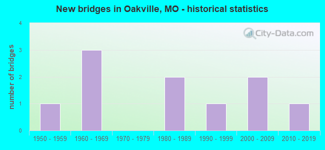
- New bridges - historical statistics
- 11950-1959
- 31960-1969
- 21980-1989
- 11990-1999
- 22000-2009
- 12010-2019


- Bridge Condition - Deck
- 12.5%Excellent
- 25.0%Good
- 25.0%Satisfactory
- 12.5%Fair
- 25.0%Poor

- Bridge Condition - Superstructure
- 12.5%Very good
- 37.5%Good
- 12.5%Satisfactory
- 25.0%Fair
- 12.5%Poor

- Bridge Condition - Substructure
- 12.5%Very good
- 37.5%Good
- 25.0%Satisfactory
- 12.5%Fair
- 12.5%Poor

- Bridge Condition - Channel
- 20.0%Good
- 60.0%Satisfactory
- 20.0%Fair
Find on map >> Show street view
Structure Number: 15648, Location: S 15 T 43 N R 6 E (Lat: 38.463681, Lng: -90.327911), Route carried "on" structure: County highway , Year Built: 1980, Status: Posted for load, Structure Length: 2.53m (8.30ft), Average Daily Traffic: 12,285 (year 2020), Truck Traffic: 25%, Average Future Daily Traffic: 16,585 (year 2040), Design Load: HS 20+Mod, Features Intersected: MATTESE CR, Facility Carried by Structure: BAUMGARTNER RD
Minimum Vertical Clearance: 30+ m (98+ ft), Kilometerpoint: 0.000, Lanes on structure: 2, Owner: County Highway Agency, Approaching Roadway Width: 16.2m (53.1ft), Material/Design: Prestressed concrete, Design/Construction: Stringer/Multi-beam, Number Of Spans In Main Unit: 2, Length of Maximum Span: 11.9m (39.0ft), Curb-To-Curb Width: 16.2m (53.1ft), Out-to-Out Width: 17.2m (56.4ft)
Condition: Deck: Good, Superstructure: Good, Substructure: Good, Channel: Good, Operating Rating: 61.2 metric tons, Method Used To Determine Operating Rating: Allowable Stress (AS), Inventory Rating: 35.1 metric tons, Method Used To Determine Inventory Rating: Allowable Stress (AS), Structural Evaluation: Better than present minimum criteria, Deck Geometry: Superior to present desirable criteria, Waterway Adequacy: Equal to present minimum criteria, Approach Roadway Alignment: Equal to present desirable criteria, Designated Inspection Frequency: Every 24 months, Inspection Date: March 2020, Deck Structure Type: Concrete Cast-file-Place, Wearing Surface/Protective System: Wearing Surface: Monolithic Concrete, Membrane: Epoxy, Deck Protection: Epoxy Coated Reinforcing
Find on map >> Show street view
Structure Number: 15649, Location: S 14 T 43 N R 6 E (Lat: 38.458358, Lng: -90.324847), Route carried "on" structure: County highway , Year Built: 1967, Status: Posted for load, Structure Length: 2.47m (8.10ft), Average Daily Traffic: 6,582 (year 2020), Truck Traffic: 2%, Average Future Daily Traffic: 8,886 (year 2040), Design Load: HS 20, Features Intersected: BR OF MATESE CR, Facility Carried by Structure: HEINTZ RD
Minimum Vertical Clearance: 30+ m (98+ ft), Kilometerpoint: 2.092, Lanes on structure: 2, Owner: County Highway Agency, Approaching Roadway Width: 7.9m (25.9ft), Material/Design: Concrete continuous, Design/Construction: Slab, Number Of Spans In Main Unit: 3, Length of Maximum Span: 9.4m (30.8ft), Curb or Sidewalk Widths: Left: 1.2m (3.9ft), Right: 0.0m, Curb-To-Curb Width: 7.9m (25.9ft), Out-to-Out Width: 9.8m (32.2ft)
Condition: Deck: Poor, Superstructure: Poor, Substructure: Poor, Channel: Satisfactory, Operating Rating: 63.0 metric tons, Method Used To Determine Operating Rating: Allowable Stress (AS), Inventory Rating: 22.5 metric tons, Method Used To Determine Inventory Rating: Allowable Stress (AS), Structural Evaluation: Meets minimum limits, Deck Geometry: High priority of replacement, Waterway Adequacy: Better than present minimum criteria, Approach Roadway Alignment: Equal to present minimum criteria, Length Of Structure Improvement: 0.33m (1.08ft), Designated Inspection Frequency: Every 24 months, Inspection Date: March 2020, Bridge Improvement Cost: $415,000, Roadway Improvement Cost: $41,000, Total Project Cost: $622,000 ( Estimate for 2022), Deck Structure Type: Concrete Cast-file-Place, Wearing Surface/Protective System: Wearing Surface: Bituminous
Find on map >> Show street view
Structure Number: 1565, Location: S 31 T 64 N R 32 W (Lat: 40.312917, Lng: -94.547283), Route carried "on" structure: State highway B, Year Built: 1967, Status: Open, Structure Length: 3.23m (10.60ft), Average Daily Traffic: 440 (year 2021), Truck Traffic: 11%, Average Future Daily Traffic: 572 (year 2041), Design Load: H 15, Features Intersected: ZOUNDS CR
Minimum Vertical Clearance: 30+ m (98+ ft), Kilometerpoint: 8.240, Lanes on structure: 2, Owner: State Highway Agency, Approaching Roadway Width: 6.1m (20.0ft), Skew: 3 degrees, Material/Design: Steel, Design/Construction: Stringer/Multi-beam, Number Of Spans In Main Unit: 3, Length of Maximum Span: 13.8m (45.3ft), Curb-To-Curb Width: 7.9m (25.9ft), Out-to-Out Width: 8.8m (28.9ft)
Condition: Deck: Poor, Superstructure: Good, Substructure: Good, Channel: Satisfactory, Operating Rating: 35.1 metric tons, Method Used To Determine Operating Rating: Allowable Stress (AS), Inventory Rating: 18.9 metric tons, Method Used To Determine Inventory Rating: Allowable Stress (AS), Structural Evaluation: Somewhat better than minimum adequacy, Deck Geometry: Somewhat better than minimum adequacy, Waterway Adequacy: Equal to present minimum criteria, Approach Roadway Alignment: Equal to present desirable criteria, Length Of Structure Improvement: 0.41m (1.35ft), Designated Inspection Frequency: Every 24 months, Inspection Date: November 2021, Bridge Improvement Cost: $319,000, Roadway Improvement Cost: $32,000, Total Project Cost: $479,000 ( Estimate for 2022), Deck Structure Type: Concrete Cast-file-Place, Wearing Surface/Protective System: Wearing Surface: Monolithic Concrete
Find on map >> Show street view
Structure Number: 1565, Location: S 1 T 43 N R 6 E (Lat: 38.490839, Lng: -90.293128), Route carried "on" structure: County highway , Year Built: 1982, Status: Posted for load, Structure Length: 2.04m (6.69ft), Average Daily Traffic: 1,485 (year 2020), Truck Traffic: 5%, Average Future Daily Traffic: 2,005 (year 2040), Design Load: HS 20, Features Intersected: MARTIGNEY CR, Facility Carried by Structure: SUNRISE HEIGHTS DR
Minimum Vertical Clearance: 30+ m (98+ ft), Kilometerpoint: 2.414, Lanes on structure: 2, Owner: County Highway Agency, Approaching Roadway Width: 8.2m (26.9ft), Material/Design: Prestressed concrete, Design/Construction: Box Beam or Girders - Multiple, Number Of Spans In Main Unit: 1, Length of Maximum Span: 19.5m (64.0ft), Curb or Sidewalk Widths: Left: 1.6m (5.2ft), Right: 0.0m, Curb-To-Curb Width: 8.5m (27.9ft), Out-to-Out Width: 11.0m (36.1ft)
Condition: Deck: Satisfactory, Superstructure: Satisfactory, Substructure: Good, Channel: Satisfactory, Operating Rating: 38.7 metric tons, Method Used To Determine Operating Rating: Allowable Stress (AS), Inventory Rating: 22.5 metric tons, Method Used To Determine Inventory Rating: Allowable Stress (AS), Structural Evaluation: Equal to present minimum criteria, Deck Geometry: Somewhat better than minimum adequacy, Waterway Adequacy: Equal to present desirable criteria, Approach Roadway Alignment: Equal to present minimum criteria, Designated Inspection Frequency: Every 24 months, Inspection Date: March 2020, Deck Structure Type: Other, Wearing Surface/Protective System: Wearing Surface: Bituminous
Find on map >> Show street view
Structure Number: 15652, Location: S 10 T 43 N R 6 E (Lat: 38.474656, Lng: -90.327964), Route carried "on" structure: County highway , Year Built: 1957, Year Reconstructed: 1996, Status: Posted for load, Structure Length: 2.19m (7.19ft), Average Daily Traffic: 2,736 (year 2020), Truck Traffic: 10%, Average Future Daily Traffic: 3,694 (year 2040), Design Load: HS 25 or greater, Features Intersected: MATTESE CR, Facility Carried by Structure: YAEGER RD
Minimum Vertical Clearance: 30+ m (98+ ft), Kilometerpoint: 3.058, Lanes on structure: 2, Owner: County Highway Agency, Approaching Roadway Width: 6.7m (22.0ft), Skew: 1 degrees, Material/Design: Prestressed concrete, Design/Construction: Box Beam or Girders - Multiple, Number Of Spans In Main Unit: 3, Length of Maximum Span: 8.8m (28.9ft), Curb or Sidewalk Widths: Left: 0.2m (0.7ft), Right: 0.2m (0.7ft), Curb-To-Curb Width: 6.9m (22.6ft), Out-to-Out Width: 7.3m (24.0ft)
Condition: Deck: Good, Superstructure: Good, Substructure: Fair, Channel: Fair, Operating Rating: 72.9 metric tons, Method Used To Determine Operating Rating: Load Factor (LF), Inventory Rating: 43.2 metric tons, Method Used To Determine Inventory Rating: Load Factor (LF), Structural Evaluation: Somewhat better than minimum adequacy, Deck Geometry: High priority of replacement, Waterway Adequacy: Somewhat better than minimum adequacy, Approach Roadway Alignment: Equal to present minimum criteria, Length Of Structure Improvement: 0.30m (0.98ft), Designated Inspection Frequency: Every 24 months, Inspection Date: April 2020, Bridge Improvement Cost: $256,000, Roadway Improvement Cost: $26,000, Total Project Cost: $384,000 ( Estimate for 2022), Deck Structure Type: Other, Wearing Surface/Protective System: Wearing Surface: Bituminous, Membrane: Built-up
Find on map >> Show street view
Structure Number: 15653, Location: S 10 T 43 N R 6 E (Lat: 38.483417, Lng: -90.341072), Route carried "on" structure: County highway , Year Built: 1966, Status: Posted for load, Structure Length: 3.66m (12.01ft), Average Daily Traffic: 2,978 (year 2020), Truck Traffic: 2%, Average Future Daily Traffic: 4,020 (year 2040), Design Load: HS 20, Features Intersected: MATTESE CR, Facility Carried by Structure: RINGER RD
Minimum Vertical Clearance: 30+ m (98+ ft), Kilometerpoint: 3.541, Lanes on structure: 2, Owner: County Highway Agency, Approaching Roadway Width: 7.0m (23.0ft), Material/Design: Concrete, Design/Construction: Slab, Number Of Spans In Main Unit: 3, Length of Maximum Span: 13.7m (44.9ft), Curb or Sidewalk Widths: Left: 0.9m (3.0ft), Right: 0.9m (3.0ft), Curb-To-Curb Width: 7.3m (24.0ft), Out-to-Out Width: 9.1m (29.9ft)
Condition: Deck: Fair, Superstructure: Fair, Substructure: Satisfactory, Channel: Satisfactory, Operating Rating: 63.0 metric tons, Method Used To Determine Operating Rating: Allowable Stress (AS), Inventory Rating: 22.5 metric tons, Method Used To Determine Inventory Rating: Allowable Stress (AS), Structural Evaluation: Somewhat better than minimum adequacy, Deck Geometry: High priority of replacement, Waterway Adequacy: Superior to present desirable criteria, Approach Roadway Alignment: Equal to present desirable criteria, Length Of Structure Improvement: 0.46m (1.51ft), Designated Inspection Frequency: Every 24 months, Inspection Date: April 2020, Bridge Improvement Cost: $394,000, Roadway Improvement Cost: $39,000, Total Project Cost: $591,000 ( Estimate for 2022), Deck Structure Type: Concrete Cast-file-Place, Wearing Surface/Protective System: Wearing Surface: Bituminous
Find on map >> Show street view
Structure Number: 29107, Location: S 17 T 43 N R 6 E (Lat: 38.463672, Lng: -90.361842), Route carried "on" structure: County highway , Year Built: 2000, Status: Posted for load, Structure Length: 1.86m (6.10ft), Average Daily Traffic: 19,169 (year 2020), Truck Traffic: 5%, Average Future Daily Traffic: 25,878 (year 2040), Design Load: H 20, Features Intersected: MERAMEC RVR TRIB, Facility Carried by Structure: MERAMEC BOTTOM RD
Minimum Vertical Clearance: 30+ m (98+ ft), Kilometerpoint: 0.000, Lanes on structure: 3, Owner: County Highway Agency, Approaching Roadway Width: 13.4m (44.0ft), Material/Design: Concrete continuous, Design/Construction: Culvert, Number Of Spans In Main Unit: 2, Length of Maximum Span: 2.9m (9.5ft)
Condition: Channel: Good, Culverts: Good, Structural Evaluation: Better than present minimum criteria, Waterway Adequacy: Superior to present desirable criteria, Approach Roadway Alignment: Equal to present desirable criteria, Designated Inspection Frequency: Every 24 months, Inspection Date: March 2021
Find on map >> Show street view
Structure Number: 29109, Location: S 17 T 43 N R 6 E (Lat: 38.461750, Lng: -90.369778), Route carried "on" structure: County highway , Year Built: 2000, Status: Posted for load, Structure Length: 0.76m (2.49ft), Average Daily Traffic: 3,396 (year 2020), Truck Traffic: 5%, Average Future Daily Traffic: 4,585 (year 2040), Design Load: HS 20, Features Intersected: MERAMEC RVR TRIB, Facility Carried by Structure: MERAMEC BOTTOM
Minimum Vertical Clearance: 30+ m (98+ ft), Kilometerpoint: 0.000, Lanes on structure: 3, Owner: County Highway Agency, Approaching Roadway Width: 13.4m (44.0ft), Material/Design: Concrete continuous, Design/Construction: Culvert, Number Of Spans In Main Unit: 2, Length of Maximum Span: 3.8m (12.5ft), Curb or Sidewalk Widths: Left: 1.5m (4.9ft), Right: 1.5m (4.9ft)
Condition: Channel: Satisfactory, Culverts: Good, Structural Evaluation: Better than present minimum criteria, Waterway Adequacy: Superior to present desirable criteria, Approach Roadway Alignment: Equal to present desirable criteria, Designated Inspection Frequency: Every 24 months, Inspection Date: March 2021
Find on map >> Show street view
Structure Number: 35127, Location: S 15 T 43 N R 6 E (Lat: 38.466597, Lng: -90.329306), Route carried "on" structure: County highway , Year Built: 2016, Status: Open, Structure Length: 1.83m (6.00ft), Average Daily Traffic: 995 (year 2020), Truck Traffic: 10%, Average Future Daily Traffic: 1,343 (year 2040), Features Intersected: MATTESE CR, Facility Carried by Structure: OLD BAUMGARTNER RD
Minimum Vertical Clearance: 30+ m (98+ ft), Kilometerpoint: 2.736, Lanes on structure: 2, Owner: County Highway Agency, Approaching Roadway Width: 7.3m (24.0ft), Skew: 1 degrees, Material/Design: Prestressed concrete, Design/Construction: Box Beam or Girders - Single/Spread, Number Of Spans In Main Unit: 1, Length of Maximum Span: 18.3m (60.0ft), Curb-To-Curb Width: 7.3m (24.0ft), Out-to-Out Width: 8.1m (26.6ft)
Condition: Deck: Excellent, Superstructure: Very good, Substructure: Very good, Channel: Satisfactory, Operating Rating: 54.9 metric tons, Method Used To Determine Operating Rating: Load and Resistance Factor (LRFR), Inventory Rating: 42.3 metric tons, Method Used To Determine Inventory Rating: Load and Resistance Factor (LRFR), Structural Evaluation: Equal to present desirable criteria, Deck Geometry: Meets minimum limits, Waterway Adequacy: Better than present minimum criteria, Approach Roadway Alignment: Equal to present minimum criteria, Designated Inspection Frequency: Every 24 months, Inspection Date: March 2020, Deck Structure Type: Concrete Cast-file-Place, Wearing Surface/Protective System: Wearing Surface: Monolithic Concrete, Deck Protection: Epoxy Coated Reinforcing
Find on map >> Show street view
Structure Number: 4005, Location: S 33 T 43 N R 6 E (Lat: 38.419575, Lng: -90.346833), Route carried "on" structure: State highway 231, Year Built: 1995, Status: Open, Structure Length: 37.64m (123.49ft), Average Daily Traffic: 7,694 (year 2021), Truck Traffic: 7%, Average Future Daily Traffic: 10,772 (year 2041), Design Load: HS 20+Mod, Features Intersected: MERAMEC RVR
Minimum Vertical Clearance: 30+ m (98+ ft), Kilometerpoint: 15.928, Lanes on structure: 2, Base Highway Network: Yes, Owner: State Highway Agency, Approaching Roadway Width: 13.7m (44.9ft), Skew: 1 degrees, Material/Design: Steel continuous, Design/Construction: Stringer/Multi-beam, Number Of Spans In Main Unit: 3, Number Of Approach Spans: 10, Length of Maximum Span: 51.8m (169.9ft), Curb or Sidewalk Widths: Left: 0.2m (0.7ft), Right: 0.2m (0.7ft), Curb-To-Curb Width: 13.0m (42.7ft), Out-to-Out Width: 13.9m (45.6ft)
Condition: Deck: Satisfactory, Superstructure: Fair, Substructure: Satisfactory, Channel: Fair, Operating Rating: 56.7 metric tons, Method Used To Determine Operating Rating: Load Factor (LF), Inventory Rating: 34.2 metric tons, Method Used To Determine Inventory Rating: Load Factor (LF), Structural Evaluation: Somewhat better than minimum adequacy, Deck Geometry: Somewhat better than minimum adequacy, Waterway Adequacy: Equal to present desirable criteria, Approach Roadway Alignment: Equal to present desirable criteria, Designated Inspection Frequency: Every 24 months, Inspection Date: June 2020, Deck Structure Type: Concrete Cast-file-Place, Wearing Surface/Protective System: Wearing Surface: Monolithic Concrete, Deck Protection: Epoxy Coated Reinforcing