Bridge Statistics for Oak Ridge, Florida (FL)
Condition, Traffic, Stress, Structural Evaluation, Project Costs
- National Bridge Inventory (NBI) Statistics
- 18Number of bridges
- 220ft / 67.5mTotal length
- 778,150Total average daily traffic
- 110,477Total average daily truck traffic
- National Bridge Inventory (NBI) Registered Bridges for Oak Ridge
- No street view available for this location
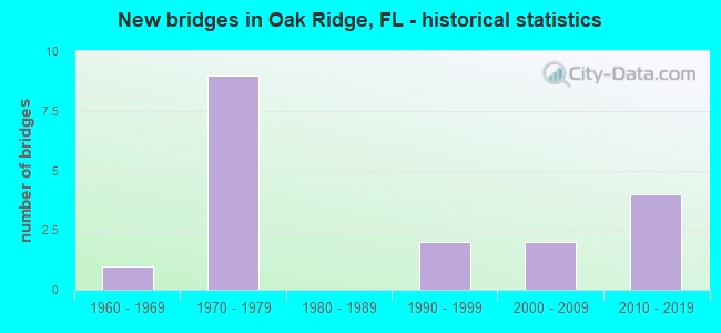
- New bridges - historical statistics
- 11960-1969
- 91970-1979
- 21990-1999
- 22000-2009
- 42010-2019

- Reconstructed bridges - Historical Statistics
- 12000-2009
- 32010-2019


- Bridge Condition - Deck
- 37.5%Very good
- 50.0%Good
- 12.5%Fair

- Bridge Condition - Superstructure
- 12.5%Very good
- 87.5%Good

- Bridge Condition - Substructure
- 37.5%Very good
- 62.5%Good
Find on map >> Show street view
Structure Number: 750092, Location: 4.3 MI E OF SR 400 I-4 (Lat: 28.433339, Lng: -81.409050), Route carried "on" structure: State highway 528, Year Built: 1973, Year Reconstructed: 2019, Status: Open, Structure Length: 10.82m (35.50ft), Average Daily Traffic: 19,025 (year 2020), Truck Traffic: 11%, Average Future Daily Traffic: 33,008 (year 2042), Design Load: HS 20, Features Intersected: SR 91 TPK 255.8
Minimum Vertical Clearance: 30+ m (98+ ft), Kilometerpoint: 6.859, Lanes on structure: 2, Lanes under structure: 11, Base Highway Network: Yes, Toll: On toll road, Owner: State Toll Authority, Approaching Roadway Width: 20.7m (67.9ft), Skew: 2 degrees, Material/Design: Prestressed concrete, Design/Construction: Stringer/Multi-beam, Number Of Spans In Main Unit: 6, Length of Maximum Span: 24.1m (79.1ft), Curb-To-Curb Width: 20.7m (67.9ft), Out-to-Out Width: 21.7m (71.2ft)
Condition: Deck: Good, Superstructure: Good, Substructure: Good, Operating Rating: 44.5 metric tons, Method Used To Determine Operating Rating: Load and Resistance Factor (LRFR), Inventory Rating: 32.7 metric tons, Method Used To Determine Inventory Rating: Load and Resistance Factor (LRFR), Structural Evaluation: Better than present minimum criteria, Deck Geometry: Superior to present desirable criteria, Underclear: High priority of corrective action, Approach Roadway Alignment: Equal to present desirable criteria, Designated Inspection Frequency: Every 24 months, Inspection Date: September 2021, Deck Structure Type: Concrete Cast-file-Place
Find on map >> Show street view
Structure Number: 750219, Location: 4.3 MI E OF SR 400 I-4 (Lat: 28.433139, Lng: -81.408897), Route carried "on" structure: State highway 528, Year Built: 1973, Year Reconstructed: 2019, Status: Open, Structure Length: 10.82m (35.50ft), Average Daily Traffic: 19,025 (year 2020), Truck Traffic: 11%, Average Future Daily Traffic: 33,008 (year 2042), Design Load: HS 20, Features Intersected: SR 91 TPK 255.8
Minimum Vertical Clearance: 30+ m (98+ ft), Kilometerpoint: 6.870, Lanes on structure: 3, Lanes under structure: 11, Base Highway Network: Yes, Toll: On toll road, Owner: State Toll Authority, Approaching Roadway Width: 20.7m (67.9ft), Skew: 2 degrees, Material/Design: Prestressed concrete, Design/Construction: Stringer/Multi-beam, Number Of Spans In Main Unit: 6, Length of Maximum Span: 24.0m (78.7ft), Curb-To-Curb Width: 20.7m (67.9ft), Out-to-Out Width: 21.7m (71.2ft)
Condition: Deck: Good, Superstructure: Good, Substructure: Good, Operating Rating: 42.8 metric tons, Method Used To Determine Operating Rating: Load and Resistance Factor (LRFR), Inventory Rating: 33.3 metric tons, Method Used To Determine Inventory Rating: Load and Resistance Factor (LRFR), Structural Evaluation: Better than present minimum criteria, Deck Geometry: Superior to present desirable criteria, Underclear: High priority of corrective action, Approach Roadway Alignment: Equal to present desirable criteria, Designated Inspection Frequency: Every 24 months, Inspection Date: September 2021, Deck Structure Type: Concrete Cast-file-Place
Find on map >> Show street view
Structure Number: 750294, Location: SR-482 WB over Turnpike (Lat: 28.450561, Lng: -81.421103), Route carried "on" structure: State highway 482, Year Built: 1979, Year Reconstructed: 2007, Status: Open, Structure Length: 8.17m (26.80ft), Average Daily Traffic: 22,250 (year 2020), Truck Traffic: 5%, Average Future Daily Traffic: 38,604 (year 2042), Design Load: HS 20, Features Intersected: Florida Turnpike
Minimum Vertical Clearance: 30+ m (98+ ft), Kilometerpoint: 5.412, Lanes on structure: 3, Lanes under structure: 8, Owner: State Highway Agency, Approaching Roadway Width: 13.9m (45.6ft), Skew: 3 degrees, Material/Design: Prestressed concrete, Design/Construction: Stringer/Multi-beam, Number Of Spans In Main Unit: 4, Length of Maximum Span: 27.1m (88.9ft), Curb-To-Curb Width: 17.2m (56.4ft), Out-to-Out Width: 17.8m (58.4ft)
Condition: Deck: Fair, Superstructure: Good, Substructure: Good, Operating Rating: 58.4 metric tons, Method Used To Determine Operating Rating: Load Factor (LF), Inventory Rating: 34.9 metric tons, Method Used To Determine Inventory Rating: Load Factor (LF), Structural Evaluation: Better than present minimum criteria, Deck Geometry: Superior to present desirable criteria, Underclear: Equal to present minimum criteria, Approach Roadway Alignment: Equal to present desirable criteria, Designated Inspection Frequency: Every 24 months, Inspection Date: August 2021, Deck Structure Type: Concrete Precast Panels, Wearing Surface/Protective System: Wearing Surface: Monolithic Concrete
Find on map >> Show street view
Structure Number: 750568, Location: SR-482 EB over Turnpike (Lat: 28.450475, Lng: -81.421033), Route carried "on" structure: State highway 482, Year Built: 2007, Status: Open, Structure Length: 7.46m (24.48ft), Average Daily Traffic: 22,250 (year 2020), Truck Traffic: 5%, Average Future Daily Traffic: 38,604 (year 2042), Design Load: HS 20, Features Intersected: Florida Turnpike
Minimum Vertical Clearance: 30+ m (98+ ft), Kilometerpoint: 5.428, Lanes on structure: 3, Lanes under structure: 8, Owner: State Highway Agency, Approaching Roadway Width: 17.1m (56.1ft), Material/Design: Prestressed concrete, Design/Construction: Stringer/Multi-beam, Number Of Spans In Main Unit: 2, Length of Maximum Span: 37.0m (121.4ft), Curb-To-Curb Width: 17.1m (56.1ft), Out-to-Out Width: 18.0m (59.1ft)
Condition: Deck: Very good, Superstructure: Very good, Substructure: Very good, Operating Rating: 71.8 metric tons, Method Used To Determine Operating Rating: Load Factor (LF), Inventory Rating: 43.1 metric tons, Method Used To Determine Inventory Rating: Load Factor (LF), Structural Evaluation: Equal to present desirable criteria, Deck Geometry: Superior to present desirable criteria, Underclear: Better than present minimum criteria, Approach Roadway Alignment: Equal to present desirable criteria, Designated Inspection Frequency: Every 24 months, Inspection Date: August 2021, Deck Structure Type: Concrete Cast-file-Place, Wearing Surface/Protective System: Wearing Surface: Monolithic Concrete
Find on map >> Show street view
Structure Number: 750602, Location: 0.06 MI N OF EXIT 254 (Lat: 28.431317, Lng: -81.403111), Route carried "on" structure: Ramp State highway 91, Year Built: 1963, Year Reconstructed: 2018, Status: Open, Structure Length: 0.65m (2.13ft), Average Daily Traffic: 5,100 (year 2020), Truck Traffic: 12%, Average Future Daily Traffic: 8,848 (year 2042), Design Load: HS 20+Mod, Features Intersected: CANAL
Minimum Vertical Clearance: 30+ m (98+ ft), Kilometerpoint: 0.644, Lanes on structure: 6, Toll: On toll road, Owner: State Toll Authority, Approaching Roadway Width: 31.3m (102.7ft), Skew: 22 degrees, Material/Design: Concrete, Design/Construction: Culvert, Number Of Spans In Main Unit: 2, Length of Maximum Span: 3.1m (10.2ft)
Condition: Channel: Good, Culverts: Good, Operating Rating: 44.7 metric tons, Method Used To Determine Operating Rating: Load and Resistance Factor (LRFR), Inventory Rating: 34.6 metric tons, Method Used To Determine Inventory Rating: Load and Resistance Factor (LRFR), Structural Evaluation: Better than present minimum criteria, Waterway Adequacy: Equal to present minimum criteria, Approach Roadway Alignment: Equal to present desirable criteria, Designated Inspection Frequency: Every 24 months, Underwater Inspection Frequency: Every 24 months, Inspection Date: September 2021, Underwater Inspection Date: September 2021
Find on map >> Show street view
Structure Number: 750629, Location: OVER CR 423 (JYP) (Lat: 28.421625, Lng: -81.422819), Route carried "on" structure: Ramp State highway 528, Year Built: 2018, Status: Open, Structure Length: 8.94m (29.33ft), Average Daily Traffic: 2,900 (year 2020), Truck Traffic: 12%, Average Future Daily Traffic: 5,032 (year 2042), Design Load: HL 93, Features Intersected: CR 423 (JYP)
Minimum Vertical Clearance: 30+ m (98+ ft), Kilometerpoint: 0.124, Lanes on structure: 1, Lanes under structure: 9, Base Highway Network: Yes, Toll: On toll road, Owner: State Toll Authority, Approaching Roadway Width: 8.2m (26.9ft), Skew: 2 degrees, Material/Design: Prestressed concrete, Design/Construction: Stringer/Multi-beam, Number Of Spans In Main Unit: 4, Length of Maximum Span: 28.7m (94.2ft), Curb-To-Curb Width: 8.2m (26.9ft), Out-to-Out Width: 9.2m (30.2ft)
Condition: Deck: Very good, Superstructure: Good, Substructure: Very good, Operating Rating: 61.9 metric tons, Method Used To Determine Operating Rating: Load and Resistance Factor (LRFR), Inventory Rating: 38.2 metric tons, Method Used To Determine Inventory Rating: Load and Resistance Factor (LRFR), Structural Evaluation: Better than present minimum criteria, Deck Geometry: Superior to present desirable criteria, Underclear: Meets minimum limits, Approach Roadway Alignment: Better than present minimum criteria, Designated Inspection Frequency: Every 24 months, Inspection Date: December 2021, Deck Structure Type: Concrete Cast-file-Place
Find on map >> Show street view
Structure Number: 75063, Location: OVER CR 423 (JYP) (Lat: 28.422281, Lng: -81.422844), Route carried "on" structure: Ramp State highway 528, Year Built: 2018, Status: Open, Structure Length: 9.31m (30.54ft), Average Daily Traffic: 6,500 (year 2020), Truck Traffic: 12%, Average Future Daily Traffic: 11,278 (year 2042), Design Load: HL 93, Features Intersected: CR 423 (JYP)
Minimum Vertical Clearance: 30.18m (99.02ft), Kilometerpoint: 0.509, Lanes on structure: 1, Lanes under structure: 9, Base Highway Network: Yes, Toll: On toll road, Owner: State Toll Authority, Approaching Roadway Width: 8.2m (26.9ft), Skew: 2 degrees, Material/Design: Prestressed concrete, Design/Construction: Stringer/Multi-beam, Number Of Spans In Main Unit: 4, Length of Maximum Span: 28.2m (92.5ft), Curb-To-Curb Width: 8.2m (26.9ft), Out-to-Out Width: 9.2m (30.2ft)
Condition: Deck: Very good, Superstructure: Good, Substructure: Very good, Operating Rating: 46.9 metric tons, Method Used To Determine Operating Rating: Load and Resistance Factor (LRFR), Inventory Rating: 36.2 metric tons, Method Used To Determine Inventory Rating: Load and Resistance Factor (LRFR), Structural Evaluation: Better than present minimum criteria, Deck Geometry: Superior to present desirable criteria, Underclear: Meets minimum limits, Approach Roadway Alignment: Better than present minimum criteria, Designated Inspection Frequency: Every 24 months, Inspection Date: December 2021, Deck Structure Type: Concrete Cast-file-Place
Find on map >> Show street view
Structure Number: 754067, Location: 0.9 mi W of Jhn Yng Pkwy (Lat: 28.472275, Lng: -81.429969), Route carried "on" structure: County highway 506, Year Built: 1972, Status: Open, Structure Length: 3.91m (12.83ft), Average Daily Traffic: 25,000 (year 2021), Truck Traffic: 5%, Average Future Daily Traffic: 43,375 (year 2042), Design Load: HS 20, Features Intersected: Shingle Creek, Facility Carried by Structure: Oak Ridge Road WB
Minimum Vertical Clearance: 30+ m (98+ ft), Kilometerpoint: 1.988, Lanes on structure: 2, Owner: County Highway Agency, Approaching Roadway Width: 9.2m (30.2ft), Skew: 2 degrees, Material/Design: Prestressed concrete, Design/Construction: Stringer/Multi-beam, Number Of Spans In Main Unit: 3, Length of Maximum Span: 13.0m (42.7ft), Curb or Sidewalk Widths: Left: 2.2m (7.2ft), Right: 0.0m, Curb-To-Curb Width: 9.2m (30.2ft), Out-to-Out Width: 12.0m (39.4ft)
Condition: Deck: Good, Superstructure: Good, Substructure: Good, Channel: Good, Operating Rating: 43.2 metric tons, Method Used To Determine Operating Rating: Allowable Stress (AS), Inventory Rating: 27.9 metric tons, Method Used To Determine Inventory Rating: Allowable Stress (AS), Structural Evaluation: Better than present minimum criteria, Deck Geometry: Meets minimum limits, Waterway Adequacy: Equal to present minimum criteria, Approach Roadway Alignment: Equal to present desirable criteria, Designated Inspection Frequency: Every 24 months, Underwater Inspection Frequency: Every 24 months, Inspection Date: October 2021, Underwater Inspection Date: October 2021, Deck Structure Type: Concrete Cast-file-Place
Find on map >> Show street view
Structure Number: 754091, Location: 0.6 Mi. N of Conroy Rd. (Lat: 28.503000, Lng: -81.483750), Route carried "on" structure: County highway 5113, Year Built: 1996, Status: Open, Structure Length: 7.38m (24.21ft), Average Daily Traffic: 31,000 (year 2020), Truck Traffic: 2%, Average Future Daily Traffic: 53,785 (year 2042), Design Load: HS 20, Features Intersected: SR-91, Facility Carried by Structure: Hiawassee Road
Minimum Vertical Clearance: 30+ m (98+ ft), Kilometerpoint: 0.978, Lanes on structure: 4, Lanes under structure: 8, Owner: County Highway Agency, Approaching Roadway Width: 15.9m (52.2ft), Skew: 24 degrees, Material/Design: Prestressed concrete, Design/Construction: Stringer/Multi-beam, Number Of Spans In Main Unit: 2, Length of Maximum Span: 36.6m (120.1ft), Curb or Sidewalk Widths: Left: 1.6m (5.2ft), Right: 1.6m (5.2ft), Curb-To-Curb Width: 15.9m (52.2ft), Out-to-Out Width: 26.9m (88.3ft)
Condition: Deck: Good, Superstructure: Good, Substructure: Good, Operating Rating: 76.7 metric tons, Method Used To Determine Operating Rating: Load Factor (LF), Inventory Rating: 47.5 metric tons, Method Used To Determine Inventory Rating: Load Factor (LF), Structural Evaluation: Better than present minimum criteria, Deck Geometry: Meets minimum limits, Underclear: Equal to present minimum criteria, Approach Roadway Alignment: Equal to present desirable criteria, Designated Inspection Frequency: Every 24 months, Inspection Date: November 2020, Deck Structure Type: Concrete Cast-file-Place
Find on map >> Show street view
Structure Number: 750092, Location: 4.3 MI E OF SR 400 I-4 (Lat: 28.433339, Lng: -81.409050), Route carried "under" structure: State highway 91, Year Built: 1973, Structure Length: 0. m, Average Daily Traffic: 88,500 (year 2020), Truck Traffic: 21%, Features Intersected: SR 91 TPK 255.8, Facility Carried by Structure: SR 528 WB 4.3
Minimum Vertical Clearance: 5.03m (16.50ft), Kilometerpoint: 10.292, Lanes on structure: 2, Lanes under structure: 7, Toll: On toll road, Material/Design: Prestressed concrete, Design/Construction: Stringer/Multi-beam, Length of Maximum Span: 24.1m (79.1ft)
Find on map >> Show street view
Structure Number: 750092, Location: 4.3 MI E OF SR 400 I-4 (Lat: 28.433339, Lng: -81.409050), Route carried "under" structure: City street , Year Built: 1973, Structure Length: 0. m, Average Daily Traffic: 34,400 (year 2015), Truck Traffic: 14%, Features Intersected: SR 91 TPK 255.8, Facility Carried by Structure: SR 528 WB 4.3
Minimum Vertical Clearance: 5.03m (16.50ft), Kilometerpoint: 0.000, Lanes on structure: 2, Lanes under structure: 4, Material/Design: Prestressed concrete, Design/Construction: Stringer/Multi-beam, Length of Maximum Span: 24.1m (79.1ft)
Find on map >> Show street view
Structure Number: 750219, Location: 4.3 MI E OF SR 400 I-4 (Lat: 28.433139, Lng: -81.408897), Route carried "under" structure: City street , Year Built: 1973, Structure Length: 0. m, Average Daily Traffic: 34,400 (year 2015), Truck Traffic: 14%, Features Intersected: SR 91 TPK 255.8, Facility Carried by Structure: SR 528 EB 4.3
Minimum Vertical Clearance: 5.03m (16.50ft), Kilometerpoint: 0.000, Lanes on structure: 3, Lanes under structure: 4, Material/Design: Prestressed concrete, Design/Construction: Stringer/Multi-beam, Length of Maximum Span: 24.0m (78.7ft)
Find on map >> Show street view
Structure Number: 750219, Location: 4.3 MI E OF SR 400 I-4 (Lat: 28.433139, Lng: -81.408897), Route carried "under" structure: State highway 91, Year Built: 1973, Structure Length: 0. m, Average Daily Traffic: 88,500 (year 2020), Truck Traffic: 21%, Features Intersected: SR 91 TPK 255.8, Facility Carried by Structure: SR 528 EB 4.3
Minimum Vertical Clearance: 5.03m (16.50ft), Kilometerpoint: 10.268, Lanes on structure: 3, Lanes under structure: 7, Toll: On toll road, Material/Design: Prestressed concrete, Design/Construction: Stringer/Multi-beam, Length of Maximum Span: 24.0m (78.7ft)
Find on map >> Show street view
Structure Number: 750294, Location: SR-482 WB over Turnpike (Lat: 28.450561, Lng: -81.421103), Route carried "under" structure: State highway 91, Year Built: 1979, Structure Length: 0. m, Average Daily Traffic: 98,100 (year 2020), Truck Traffic: 21%, Features Intersected: Florida Turnpike, Facility Carried by Structure: SR-482 WB
Minimum Vertical Clearance: 4.75m (15.58ft), Kilometerpoint: 12.521, Lanes on structure: 3, Lanes under structure: 8, Toll: On toll road, Material/Design: Prestressed concrete, Design/Construction: Stringer/Multi-beam, Length of Maximum Span: 27.1m (88.9ft)
Find on map >> Show street view
Structure Number: 750568, Location: SR-482 EB over Turnpike (Lat: 28.450475, Lng: -81.421033), Route carried "under" structure: Interstate 91, Year Built: 2007, Structure Length: 0. m, Average Daily Traffic: 56,400 (year 2006), Truck Traffic: 14%, Features Intersected: Florida Turnpike, Facility Carried by Structure: SR-482 EB
Minimum Vertical Clearance: 5.30m (17.39ft), Kilometerpoint: 12.490, Lanes on structure: 3, Lanes under structure: 8, Toll: On toll road, Material/Design: Prestressed concrete, Design/Construction: Stringer/Multi-beam, Length of Maximum Span: 37.0m (121.4ft)
Find on map >> Show street view
Structure Number: 750629, Location: OVER CR 423 (JYP) (Lat: 28.421625, Lng: -81.422819), Route carried "under" structure: County highway 423, Year Built: 2018, Structure Length: 0. m, Average Daily Traffic: 54,400 (year 2000), Truck Traffic: 5%, Features Intersected: CR 423 (JYP), Facility Carried by Structure: SR528 EB RMP 3.083
Minimum Vertical Clearance: 5.19m (17.03ft), Kilometerpoint: 0.274, Lanes on structure: 1, Lanes under structure: 9, Material/Design: Prestressed concrete, Design/Construction: Stringer/Multi-beam, Length of Maximum Span: 28.7m (94.2ft)
Find on map >> Show street view
Structure Number: 75063, Location: OVER CR 423 (JYP) (Lat: 28.422281, Lng: -81.422844), Route carried "under" structure: County highway 423, Year Built: 2018, Structure Length: 0. m, Average Daily Traffic: 54,400 (year 2000), Truck Traffic: 5%, Features Intersected: CR 423 (JYP), Facility Carried by Structure: SR528 WB RMP 3.107
Minimum Vertical Clearance: 5.21m (17.09ft), Kilometerpoint: 0.563, Lanes on structure: 1, Lanes under structure: 9, Material/Design: Prestressed concrete, Design/Construction: Stringer/Multi-beam, Length of Maximum Span: 28.2m (92.5ft)
Find on map >> Show street view
Structure Number: 754091, Location: 0.6 Mi. N of Conroy Rd. (Lat: 28.503000, Lng: -81.483750), Route carried "under" structure: Other road 91, Year Built: 1996, Structure Length: 0. m, Average Daily Traffic: 116,000 (year 2020), Truck Traffic: 17%, Features Intersected: SR-91, Facility Carried by Structure: Hiawassee Road
Minimum Vertical Clearance: 5.27m (17.29ft), Kilometerpoint: 21.132, Lanes on structure: 4, Lanes under structure: 8, Toll: On toll road, Material/Design: Prestressed concrete, Design/Construction: Stringer/Multi-beam, Length of Maximum Span: 36.6m (120.1ft)