Bridge Statistics for Oak Park, Illinois (IL)
Condition, Traffic, Stress, Structural Evaluation, Project Costs
- National Bridge Inventory (NBI) Statistics
- 13Number of bridges
- 151ft / 45.6mTotal length
- $17,300,000Total costs
- 1,021,000Total average daily traffic
- 60,344Total average daily truck traffic
- National Bridge Inventory (NBI) Registered Bridges for Oak Park
- No street view available for this location
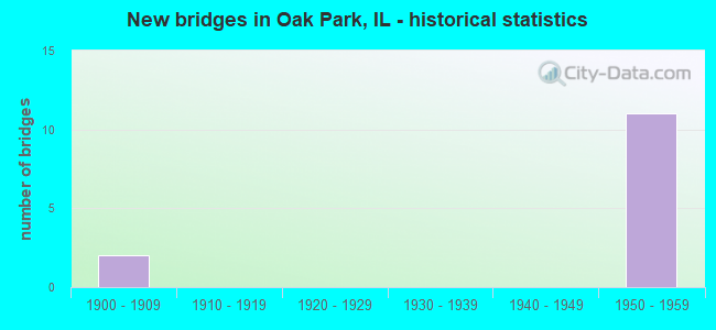
- New bridges - historical statistics
- 21900-1909
- 111950-1959

- Reconstructed bridges - Historical Statistics
- 11970-1979
- 11980-1989
- 11990-1999


- Bridge Condition - Deck
- 40.0%Satisfactory
- 40.0%Fair
- 20.0%Poor

- Bridge Condition - Superstructure
- 80.0%Fair
- 20.0%Serious

- Bridge Condition - Substructure
- 20.0%Satisfactory
- 80.0%Fair
Find on map >> Show street view
Structure Number: 16071, Location: 2 M W IL 50 (Lat: 41.871661, Lng: -87.784175), Route carried "on" structure: Other road , Year Built: 1957, Year Reconstructed: 1991, Status: Open, Structure Length: 9.75m (31.99ft), Average Daily Traffic: 10,600 (year 2021), Truck Traffic: 2%, Average Future Daily Traffic: 9,991 (year 2032), Design Load: HS 20, Features Intersected: I-290, CTA, CSX RR, Facility Carried by Structure: RIDGELAND AVE
Minimum Vertical Clearance: 30+ m (98+ ft), Kilometerpoint: 3.347, Lanes on structure: 4, Lanes under structure: 6, Owner: State Highway Agency, Approaching Roadway Width: 13.4m (44.0ft), Material/Design: Steel continuous, Design/Construction: Stringer/Multi-beam, Number Of Spans In Main Unit: 4, Length of Maximum Span: 24.5m (80.4ft), Curb or Sidewalk Widths: Left: 1.8m (5.9ft), Right: 1.8m (5.9ft), Curb-To-Curb Width: 13.4m (44.0ft), Out-to-Out Width: 18.1m (59.4ft)
Condition: Deck: Fair, Superstructure: Fair, Substructure: Fair, Operating Rating: 55.1 metric tons, Method Used To Determine Operating Rating: Allowable Stress (AS) rating reported by rating factor (RF) method using MS18 loading, Inventory Rating: 36.0 metric tons, Method Used To Determine Inventory Rating: Allowable Stress (AS) rating reported by rating factor (RF) method using MS18 loading, Structural Evaluation: Somewhat better than minimum adequacy, Deck Geometry: High priority of replacement, Underclear: High priority of replacement, Approach Roadway Alignment: Equal to present desirable criteria, Length Of Structure Improvement: 11.03m (36.19ft), Designated Inspection Frequency: Every 24 months, Inspection Date: January 2020, Bridge Improvement Cost: $2,519,000, Roadway Improvement Cost: $252,000, Total Project Cost: $3,779,000, Deck Structure Type: Concrete Cast-file-Place, Wearing Surface/Protective System: Wearing Surface: Integral Concrete
Find on map >> Show street view
Structure Number: 162061, Location: 2.2 M W IL 50 (Lat: 41.872067, Lng: -87.789067), Route carried "on" structure: Other road , Year Built: 1957, Year Reconstructed: 1984, Status: Open, Structure Length: 9.00m (29.53ft), Average Daily Traffic: 4,500 (year 2018), Truck Traffic: 2%, Average Future Daily Traffic: 6,283 (year 2032), Design Load: HS 20, Features Intersected: I-290, CTA, CSX RR, Facility Carried by Structure: EAST AVE
Minimum Vertical Clearance: 30+ m (98+ ft), Kilometerpoint: 1.851, Lanes on structure: 4, Lanes under structure: 6, Owner: State Highway Agency, Approaching Roadway Width: 9.1m (29.9ft), Material/Design: Steel continuous, Design/Construction: Stringer/Multi-beam, Number Of Spans In Main Unit: 4, Length of Maximum Span: 19.8m (65.0ft), Curb-To-Curb Width: 13.4m (44.0ft), Out-to-Out Width: 17.4m (57.1ft)
Condition: Deck: Poor, Superstructure: Serious, Substructure: Fair, Operating Rating: 62.9 metric tons, Method Used To Determine Operating Rating: Load Factor (LF) rating reported by rating factor (RF) method using MS18 loading, Inventory Rating: 37.6 metric tons, Method Used To Determine Inventory Rating: Load Factor (LF) rating reported by rating factor (RF) method using MS18 loading, Structural Evaluation: High priority of corrective action, Deck Geometry: High priority of replacement, Underclear: High priority of replacement, Approach Roadway Alignment: Equal to present desirable criteria, Length Of Structure Improvement: 6.74m (22.11ft), Designated Inspection Frequency: Every 12 months, Inspection Date: July 2021, Bridge Improvement Cost: $1,360,000, Roadway Improvement Cost: $136,000, Total Project Cost: $2,040,000, Deck Structure Type: Concrete Cast-file-Place, Wearing Surface/Protective System: Wearing Surface: Integral Concrete, Deck Protection: Epoxy Coated Reinforcing
Find on map >> Show street view
Structure Number: 162062, Location: 1.8 M W IL 50 (Lat: 41.872186, Lng: -87.779247), Route carried "on" structure: Other road , Year Built: 1957, Status: Open, Structure Length: 9.84m (32.28ft), Average Daily Traffic: 3,050 (year 2018), Truck Traffic: 6%, Average Future Daily Traffic: 2,833 (year 2032), Design Load: HS 20, Features Intersected: I-290, CTA, CSX RR, Facility Carried by Structure: LOMBARD AVE
Minimum Vertical Clearance: 30+ m (98+ ft), Kilometerpoint: 1.770, Lanes on structure: 2, Lanes under structure: 7, Owner: State Highway Agency, Approaching Roadway Width: 14.6m (47.9ft), Material/Design: Steel continuous, Design/Construction: Stringer/Multi-beam, Number Of Spans In Main Unit: 5, Length of Maximum Span: 26.5m (86.9ft), Curb or Sidewalk Widths: Left: 1.7m (5.6ft), Right: 1.7m (5.6ft), Curb-To-Curb Width: 9.1m (29.9ft), Out-to-Out Width: 13.2m (43.3ft)
Condition: Deck: Satisfactory, Superstructure: Fair, Substructure: Satisfactory, Operating Rating: 55.7 metric tons, Method Used To Determine Operating Rating: Allowable Stress (AS) rating reported by rating factor (RF) method using MS18 loading, Inventory Rating: 34.3 metric tons, Method Used To Determine Inventory Rating: Allowable Stress (AS) rating reported by rating factor (RF) method using MS18 loading, Structural Evaluation: Somewhat better than minimum adequacy, Deck Geometry: Meets minimum limits, Underclear: High priority of replacement, Approach Roadway Alignment: Better than present minimum criteria, Length Of Structure Improvement: 10.73m (35.20ft), Designated Inspection Frequency: Every 24 months, Inspection Date: Febuary 2020, Bridge Improvement Cost: $1,816,000, Roadway Improvement Cost: $182,000, Total Project Cost: $2,724,000, Deck Structure Type: Concrete Cast-file-Place, Wearing Surface/Protective System: Deck Protection: Epoxy Coated Reinforcing
Find on map >> Show street view
Structure Number: 162063, Location: 1.5 M W IL 50 (Lat: 41.871567, Lng: -87.774317), Route carried "on" structure: Other road , Year Built: 1957, Year Reconstructed: 1990, Status: Open, Structure Length: 9.78m (32.09ft), Average Daily Traffic: 20,300 (year 2018), Truck Traffic: 3%, Average Future Daily Traffic: 20,806 (year 2032), Design Load: HS 20, Features Intersected: I-290, CTA, CSX RR, Facility Carried by Structure: AUSTIN BLVD
Minimum Vertical Clearance: 30+ m (98+ ft), Kilometerpoint: 13.422, Lanes on structure: 6, Lanes under structure: 6, Base Highway Network: Yes, Owner: State Highway Agency, Approaching Roadway Width: 14.6m (47.9ft), Skew: 30 degrees, Material/Design: Steel continuous, Design/Construction: Stringer/Multi-beam, Number Of Spans In Main Unit: 5, Length of Maximum Span: 19.8m (65.0ft), Curb or Sidewalk Widths: Left: 1.8m (5.9ft), Right: 1.8m (5.9ft), Curb-To-Curb Width: 21.3m (69.9ft), Out-to-Out Width: 24.5m (80.4ft)
Condition: Deck: Satisfactory, Superstructure: Fair, Substructure: Fair, Operating Rating: 52.2 metric tons, Method Used To Determine Operating Rating: Allowable Stress (AS) rating reported by rating factor (RF) method using MS18 loading, Inventory Rating: 34.3 metric tons, Method Used To Determine Inventory Rating: Allowable Stress (AS) rating reported by rating factor (RF) method using MS18 loading, Structural Evaluation: Somewhat better than minimum adequacy, Deck Geometry: High priority of replacement, Underclear: High priority of replacement, Approach Roadway Alignment: Better than present minimum criteria, Length Of Structure Improvement: 10.76m (35.30ft), Designated Inspection Frequency: Every 24 months, Inspection Date: March 2021, Bridge Improvement Cost: $3,978,000, Roadway Improvement Cost: $398,000, Total Project Cost: $5,967,000, Deck Structure Type: Concrete Cast-file-Place, Wearing Surface/Protective System: Deck Protection: Epoxy Coated Reinforcing
Find on map >> Show street view
Structure Number: 162123, Location: 2.5 M W IL 50 (Lat: 41.872483, Lng: -87.793986), Route carried "on" structure: Other road , Year Built: 1958, Status: Open, Structure Length: 7.25m (23.79ft), Average Daily Traffic: 7,400 (year 2021), Truck Traffic: 2%, Average Future Daily Traffic: 11,639 (year 2032), Design Load: HS 20, Features Intersected: I-290, CTA, CSX RR, Facility Carried by Structure: OAK PARK AVE
Minimum Vertical Clearance: 30+ m (98+ ft), Kilometerpoint: 10.702, Lanes on structure: 4, Lanes under structure: 6, Owner: State Highway Agency, Approaching Roadway Width: 13.4m (44.0ft), Material/Design: Steel continuous, Design/Construction: Stringer/Multi-beam, Number Of Spans In Main Unit: 4, Length of Maximum Span: 19.8m (65.0ft), Curb or Sidewalk Widths: Left: 1.7m (5.6ft), Right: 1.7m (5.6ft), Curb-To-Curb Width: 14.0m (45.9ft), Out-to-Out Width: 18.3m (60.0ft)
Condition: Deck: Fair, Superstructure: Fair, Substructure: Fair, Operating Rating: 57.7 metric tons, Method Used To Determine Operating Rating: Allowable Stress (AS) rating reported by rating factor (RF) method using MS18 loading, Inventory Rating: 35.3 metric tons, Method Used To Determine Inventory Rating: Allowable Stress (AS) rating reported by rating factor (RF) method using MS18 loading, Structural Evaluation: Somewhat better than minimum adequacy, Deck Geometry: High priority of replacement, Underclear: High priority of replacement, Approach Roadway Alignment: Equal to present desirable criteria, Length Of Structure Improvement: 8.14m (26.71ft), Designated Inspection Frequency: Every 24 months, Inspection Date: Febuary 2021, Bridge Improvement Cost: $1,860,000, Roadway Improvement Cost: $186,000, Total Project Cost: $2,790,000, Deck Structure Type: Concrete Cast-file-Place, Wearing Surface/Protective System: Wearing Surface: Other
Find on map >> Show street view
Structure Number: 160709, Location: 1 M N I290 P16 (Lat: 41.887194, Lng: -87.784653), Route carried "under" structure: Other road , Year Built: 1900, Structure Length: 0. m, Average Daily Traffic: 16,000 (year 2021), Truck Traffic: 2%, Features Intersected: RIDGELAND AVE, Facility Carried by Structure: C&NW RR
Minimum Vertical Clearance: 3.73m (12.24ft), Kilometerpoint: 1.625, Lanes under structure: 2, Material/Design: Steel, Length of Maximum Span: 7.6m (24.9ft)
Find on map >> Show street view
Structure Number: 16071, Location: 2 M W IL 50 (Lat: 41.871661, Lng: -87.784175), Route carried "under" structure: Interstate 290, Year Built: 1957, Structure Length: 0. m, Average Daily Traffic: 167,800 (year 2021), Truck Traffic: 6%, Features Intersected: I-290, CTA, CSX RR, Facility Carried by Structure: RIDGELAND AVE
Minimum Vertical Clearance: 5.41m (17.75ft), Kilometerpoint: 36.354, Lanes on structure: 4, Lanes under structure: 6, Material/Design: Steel continuous, Design/Construction: Stringer/Multi-beam, Length of Maximum Span: 24.5m (80.4ft)
Find on map >> Show street view
Structure Number: 16206, Location: 2.7 M W ILL 50 P16 (Lat: 41.872953, Lng: -87.798889), Route carried "under" structure: Interstate 290, Year Built: 1958, Structure Length: 0. m, Average Daily Traffic: 141,200 (year 2021), Truck Traffic: 7%, Features Intersected: I-290, CTA, CSX RR, Facility Carried by Structure: HOME AVE PED OP
Minimum Vertical Clearance: 5.77m (18.93ft), Kilometerpoint: 35.147, Lanes under structure: 6, Material/Design: Steel continuous, Length of Maximum Span: 23.9m (78.4ft)
Find on map >> Show street view
Structure Number: 162061, Location: 2.2 M W IL 50 (Lat: 41.872067, Lng: -87.789067), Route carried "under" structure: Interstate 290, Year Built: 1957, Structure Length: 0. m, Average Daily Traffic: 167,800 (year 2021), Truck Traffic: 6%, Features Intersected: I-290, CTA, CSX RR, Facility Carried by Structure: EAST AVE
Minimum Vertical Clearance: 4.45m (14.60ft), Kilometerpoint: 35.936, Lanes on structure: 4, Lanes under structure: 6, Material/Design: Steel continuous, Design/Construction: Stringer/Multi-beam, Length of Maximum Span: 19.8m (65.0ft)
Find on map >> Show street view
Structure Number: 162062, Location: 1.8 M W IL 50 (Lat: 41.871244, Lng: -87.779217), Route carried "under" structure: Interstate 290, Year Built: 1957, Structure Length: 0. m, Average Daily Traffic: 152,800 (year 2021), Truck Traffic: 6%, Features Intersected: I-290, CTA, CSX RR, Facility Carried by Structure: LOMBARD AVE
Minimum Vertical Clearance: 5.33m (17.49ft), Kilometerpoint: 36.756, Lanes on structure: 2, Lanes under structure: 7, Material/Design: Steel continuous, Design/Construction: Stringer/Multi-beam, Length of Maximum Span: 26.5m (86.9ft)
Find on map >> Show street view
Structure Number: 162063, Location: 1.5 M W IL 50 (Lat: 41.870936, Lng: -87.774289), Route carried "under" structure: Interstate 290, Year Built: 1957, Structure Length: 0. m, Average Daily Traffic: 152,800 (year 2021), Truck Traffic: 6%, Features Intersected: I-290, CTA, CSX RR, Facility Carried by Structure: AUSTIN BLVD
Minimum Vertical Clearance: 5.72m (18.77ft), Kilometerpoint: 37.159, Lanes on structure: 6, Lanes under structure: 6, Material/Design: Steel continuous, Design/Construction: Stringer/Multi-beam, Length of Maximum Span: 19.8m (65.0ft)
Find on map >> Show street view
Structure Number: 162123, Location: 2.5 M W IL 50 (Lat: 41.872483, Lng: -87.793986), Route carried "under" structure: Interstate 290, Year Built: 1958, Structure Length: 0. m, Average Daily Traffic: 167,800 (year 2021), Truck Traffic: 6%, Features Intersected: I-290, CTA, CSX RR, Facility Carried by Structure: OAK PARK AVE
Minimum Vertical Clearance: 4.88m (16.01ft), Kilometerpoint: 35.517, Lanes on structure: 4, Lanes under structure: 6, Material/Design: Steel continuous, Design/Construction: Stringer/Multi-beam, Length of Maximum Span: 19.8m (65.0ft)
Find on map >> Show street view
Structure Number: 169942, Location: 0.9 M N I290 P16 (Lat: 41.891033, Lng: -87.794572), Route carried "under" structure: Other road , Year Built: 1900, Structure Length: 0. m, Average Daily Traffic: 8,950 (year 2018), Truck Traffic: 4%, Features Intersected: OAK PARK AVE, Facility Carried by Structure: LAKE ST CTA&C&NW R
Minimum Vertical Clearance: 3.71m (12.17ft), Kilometerpoint: 8.626, Lanes under structure: 4, Material/Design: Steel, Design/Construction: Girder and Floorbeam System, Length of Maximum Span: 6.7m (22.0ft)