Bridge Statistics for Oak Hill, West Virginia (WV)
Condition, Traffic, Stress, Structural Evaluation, Project Costs
- National Bridge Inventory (NBI) Statistics
- 15Number of bridges
- 102ft / 31.4mTotal length
- $6,448,000Total costs
- 145,326Total average daily traffic
- 15,557Total average daily truck traffic
- National Bridge Inventory (NBI) Registered Bridges for Oak Hill
- No street view available for this location
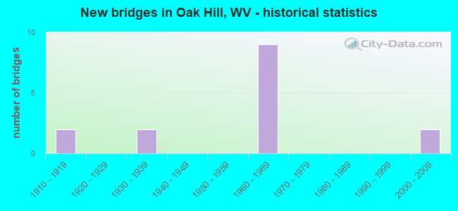
- New bridges - historical statistics
- 21910-1919
- 21930-1939
- 91960-1969
- 22000-2009


- Bridge Condition - Deck
- 14.3%Good
- 28.6%Satisfactory
- 28.6%Fair
- 28.6%Poor

- Bridge Condition - Superstructure
- 14.3%Good
- 28.6%Satisfactory
- 42.9%Fair
- 14.3%Poor

- Bridge Condition - Substructure
- 28.6%Satisfactory
- 42.9%Fair
- 28.6%Poor
Find on map >> Show street view
Structure Number: 10A092, Location: 0.06 Miles S. of CR 19/43 (Lat: 37.986200, Lng: -81.144100), Route carried "on" structure: County highway 6128, Year Built: 1965, Status: Posted for load, Structure Length: 5.66m (18.57ft), Average Daily Traffic: 2,427 (year 2020), Truck Traffic: 6%, Average Future Daily Traffic: 2,961 (year 2040), Design Load: H 15, Features Intersected: U.S. 19 NBL & SBL, Facility Carried by Structure: COUNTY ROUTE 61/28
Minimum Vertical Clearance: 30+ m (98+ ft), Kilometerpoint: 2.012, Lanes on structure: 2, Lanes under structure: 4, Owner: State Highway Agency, Approaching Roadway Width: 8.5m (27.9ft), Material/Design: Steel continuous, Design/Construction: Stringer/Multi-beam, Number Of Spans In Main Unit: 2, Number Of Approach Spans: 2, Length of Maximum Span: 15.1m (49.5ft), Curb or Sidewalk Widths: Left: 0.8m (2.6ft), Right: 0.8m (2.6ft), Curb-To-Curb Width: 7.3m (24.0ft), Out-to-Out Width: 9.4m (30.8ft)
Condition: Deck: Satisfactory, Superstructure: Satisfactory, Substructure: Fair, Operating Rating: 45.4 metric tons, Method Used To Determine Operating Rating: Load Factor (LF), Inventory Rating: 27.2 metric tons, Method Used To Determine Inventory Rating: Load Factor (LF), Structural Evaluation: Somewhat better than minimum adequacy, Deck Geometry: High priority of replacement, Underclear: Meets minimum limits, Approach Roadway Alignment: Better than present minimum criteria, Length Of Structure Improvement: 5.67m (18.60ft), Designated Inspection Frequency: Every 24 months, Inspection Date: December 2021, Bridge Improvement Cost: $146,000, Roadway Improvement Cost: $10,000, Total Project Cost: $156,000 ( Estimate for 2022), Deck Structure Type: Concrete Cast-file-Place, Wearing Surface/Protective System: Wearing Surface: Latex Concrete
Find on map >> Show street view
Structure Number: 10A096, Location: 0.54 Miles N. of CR 19/25 (Lat: 37.967769, Lng: -81.147289), Route carried "on" structure: State highway 1600, Year Built: 1961, Status: Open, Structure Length: 6.14m (20.14ft), Average Daily Traffic: 8,979 (year 2019), Truck Traffic: 6%, Average Future Daily Traffic: 10,954 (year 2039), Design Load: H 20, Features Intersected: US 19, Facility Carried by Structure: WV 16
Minimum Vertical Clearance: 30+ m (98+ ft), Kilometerpoint: 12.521, Lanes on structure: 2, Lanes under structure: 4, Owner: State Highway Agency, Approaching Roadway Width: 8.5m (27.9ft), Material/Design: Steel continuous, Design/Construction: Stringer/Multi-beam, Number Of Spans In Main Unit: 2, Length of Maximum Span: 30.2m (99.1ft), Curb or Sidewalk Widths: Left: 0.8m (2.6ft), Right: 0.8m (2.6ft), Curb-To-Curb Width: 8.5m (27.9ft), Out-to-Out Width: 10.7m (35.1ft)
Condition: Deck: Poor, Superstructure: Fair, Substructure: Poor, Operating Rating: 68.0 metric tons, Method Used To Determine Operating Rating: Load Factor (LF), Inventory Rating: 40.8 metric tons, Method Used To Determine Inventory Rating: Load Factor (LF), Structural Evaluation: Meets minimum limits, Deck Geometry: Meets minimum limits, Underclear: High priority of replacement, Approach Roadway Alignment: Somewhat better than minimum adequacy, Length Of Structure Improvement: 6.16m (20.21ft), Designated Inspection Frequency: Every 24 months, Inspection Date: June 2021, Bridge Improvement Cost: $1,448,000, Roadway Improvement Cost: $949,000, Total Project Cost: $2,398,000 ( Estimate for 2021), Deck Structure Type: Concrete Cast-file-Place, Wearing Surface/Protective System: Wearing Surface: Latex Concrete
Find on map >> Show street view
Structure Number: 10A097, Location: 0.20 Miles S. of CR 17 (Lat: 37.976389, Lng: -81.140539), Route carried "on" structure: State highway 1600, Year Built: 1960, Status: Posted for load, Structure Length: 7.26m (23.82ft), Average Daily Traffic: 7,391 (year 2020), Truck Traffic: 6%, Average Future Daily Traffic: 9,017 (year 2040), Design Load: HS 20, Features Intersected: US 19 NBL & SBL, Facility Carried by Structure: WV 16
Minimum Vertical Clearance: 30+ m (98+ ft), Kilometerpoint: 13.969, Lanes on structure: 3, Lanes under structure: 4, Owner: State Highway Agency, Approaching Roadway Width: 15.9m (52.2ft), Skew: 3 degrees, Material/Design: Steel continuous, Design/Construction: Stringer/Multi-beam, Number Of Spans In Main Unit: 1, Number Of Approach Spans: 3, Length of Maximum Span: 20.4m (66.9ft), Curb or Sidewalk Widths: Left: 1.5m (4.9ft), Right: 1.5m (4.9ft), Curb-To-Curb Width: 15.9m (52.2ft), Out-to-Out Width: 19.5m (64.0ft)
Condition: Deck: Poor, Superstructure: Fair, Substructure: Poor, Operating Rating: 55.3 metric tons, Method Used To Determine Operating Rating: Load Factor (LF), Inventory Rating: 33.6 metric tons, Method Used To Determine Inventory Rating: Load Factor (LF), Structural Evaluation: Meets minimum limits, Deck Geometry: Better than present minimum criteria, Underclear: High priority of replacement, Approach Roadway Alignment: Equal to present desirable criteria, Length Of Structure Improvement: 7.25m (23.79ft), Designated Inspection Frequency: Every 24 months, Inspection Date: September 2021, Bridge Improvement Cost: $2,105,000, Roadway Improvement Cost: $1,389,000, Total Project Cost: $3,494,000 ( Estimate for 2022), Deck Structure Type: Concrete Cast-file-Place, Wearing Surface/Protective System: Wearing Surface: Latex Concrete
Find on map >> Show street view
Structure Number: 10A098, Location: 0.13 Miles N. of CR 17/2 (Lat: 37.979831, Lng: -81.138619), Route carried "on" structure: State highway 1600, Year Built: 1939, Status: Open, Structure Length: 1.00m (3.28ft), Average Daily Traffic: 6,819 (year 2019), Truck Traffic: 8%, Average Future Daily Traffic: 8,319 (year 2039), Features Intersected: COUNTY RT 17, Facility Carried by Structure: WV 16
Minimum Vertical Clearance: 30+ m (98+ ft), Kilometerpoint: 14.452, Lanes on structure: 2, Lanes under structure: 2, Base Highway Network: Yes, Owner: State Highway Agency, Approaching Roadway Width: 9.1m (29.9ft), Skew: 5 degrees, Material/Design: Concrete, Design/Construction: Slab, Number Of Spans In Main Unit: 1, Length of Maximum Span: 9.1m (29.9ft), Curb or Sidewalk Widths: Left: 0.2m (0.7ft), Right: 0.0m, Curb-To-Curb Width: 10.7m (35.1ft), Out-to-Out Width: 13.3m (43.6ft)
Condition: Deck: Fair, Superstructure: Fair, Substructure: Satisfactory, Operating Rating: 63.5 metric tons, Method Used To Determine Operating Rating: Field evaluation and documented engineering judgment, Inventory Rating: 29.0 metric tons, Method Used To Determine Inventory Rating: Field evaluation and documented engineering judgment, Structural Evaluation: Somewhat better than minimum adequacy, Deck Geometry: Meets minimum limits, Underclear: High priority of replacement, Approach Roadway Alignment: Equal to present desirable criteria, Length Of Structure Improvement: 1.34m (4.40ft), Designated Inspection Frequency: Every 24 months, Inspection Date: January 2021, Bridge Improvement Cost: $113,000, Roadway Improvement Cost: $112,000, Total Project Cost: $248,000 ( Estimate for 2021), Deck Structure Type: Concrete Cast-file-Place, Wearing Surface/Protective System: Wearing Surface: Bituminous
Find on map >> Show street view
Structure Number: 10A131, Location: 0.10 Miles S. of CR 38/4 (Lat: 37.999400, Lng: -81.142719), Route carried "on" structure: County highway 3800, Year Built: 1964, Status: Open, Structure Length: 5.53m (18.14ft), Average Daily Traffic: 2,000 (year 2020), Truck Traffic: 6%, Average Future Daily Traffic: 2,440 (year 2040), Design Load: HS 20, Features Intersected: US 19, Facility Carried by Structure: COUNTY ROUTE 38
Minimum Vertical Clearance: 30+ m (98+ ft), Kilometerpoint: 5.681, Lanes on structure: 2, Lanes under structure: 4, Owner: State Highway Agency, Approaching Roadway Width: 8.5m (27.9ft), Material/Design: Steel continuous, Design/Construction: Stringer/Multi-beam, Number Of Spans In Main Unit: 2, Number Of Approach Spans: 2, Length of Maximum Span: 14.5m (47.6ft), Curb or Sidewalk Widths: Left: 0.8m (2.6ft), Right: 0.8m (2.6ft), Curb-To-Curb Width: 8.5m (27.9ft), Out-to-Out Width: 10.7m (35.1ft)
Condition: Deck: Satisfactory, Superstructure: Satisfactory, Substructure: Fair, Operating Rating: 53.5 metric tons, Method Used To Determine Operating Rating: Load Factor (LF), Inventory Rating: 31.7 metric tons, Method Used To Determine Inventory Rating: Load Factor (LF), Structural Evaluation: Somewhat better than minimum adequacy, Deck Geometry: Somewhat better than minimum adequacy, Underclear: Meets minimum limits, Approach Roadway Alignment: Equal to present desirable criteria, Designated Inspection Frequency: Every 24 months, Other Special Inspection Frequency: Every 12 months, Inspection Date: December 2021, Other Special Inspection Date: December 2021, Deck Structure Type: Concrete Cast-file-Place, Wearing Surface/Protective System: Wearing Surface: Latex Concrete
Find on map >> Show street view
Structure Number: 10A263, Location: 0.01 Miles W. of WV 61 (Lat: 38.012389, Lng: -81.203269), Route carried "on" structure: Other road 96900, Year Built: 1965, Status: Open, Structure Length: 0.88m (2.89ft), Average Daily Traffic: 10 (year 2020), Truck Traffic: 28%, Average Future Daily Traffic: 12 (year 2040), Features Intersected: LOOP CREEK, Facility Carried by Structure: HARP ROUTE 969
Minimum Vertical Clearance: 30+ m (98+ ft), Kilometerpoint: 0.016, Lanes on structure: 1, Owner: State Highway Agency, Approaching Roadway Width: 3.0m (9.8ft), Material/Design: Steel, Design/Construction: Stringer/Multi-beam, Number Of Spans In Main Unit: 1, Length of Maximum Span: 7.7m (25.3ft), Curb-To-Curb Width: 3.6m (11.8ft), Out-to-Out Width: 3.7m (12.1ft)
Condition: Deck: Fair, Superstructure: Poor, Substructure: Fair, Channel: Excellent, Operating Rating: 56.2 metric tons, Method Used To Determine Operating Rating: Load Factor (LF), Inventory Rating: 33.6 metric tons, Method Used To Determine Inventory Rating: Load Factor (LF), Structural Evaluation: Meets minimum limits, Deck Geometry: High priority of corrective action, Waterway Adequacy: Superior to present desirable criteria, Approach Roadway Alignment: Equal to present desirable criteria, Length Of Structure Improvement: 0.88m (2.89ft), Designated Inspection Frequency: Every 24 months, Inspection Date: December 2021, Bridge Improvement Cost: $55,000, Roadway Improvement Cost: $54,000, Total Project Cost: $152,000 ( Estimate for 2022), Deck Structure Type: Wood or Timber, Wearing Surface/Protective System: Deck Protection: Other
Find on map >> Show street view
Structure Number: 10A295, Location: 0.12 Miles W. of WV 16 (Lat: 38.007450, Lng: -81.132319), Route carried "on" structure: State highway 2118, Year Built: 2007, Status: Open, Structure Length: 4.97m (16.31ft), Average Daily Traffic: 2,100 (year 2020), Truck Traffic: 6%, Average Future Daily Traffic: 2,562 (year 2040), Features Intersected: US 19 NBL & SBL, Facility Carried by Structure: COUNTY ROUTE 21/18
Minimum Vertical Clearance: 30+ m (98+ ft), Kilometerpoint: 1.513, Lanes on structure: 3, Lanes under structure: 5, Owner: State Highway Agency, Approaching Roadway Width: 8.5m (27.9ft), Material/Design: Prestressed concrete, Design/Construction: Stringer/Multi-beam, Number Of Spans In Main Unit: 1, Number Of Approach Spans: 1, Length of Maximum Span: 26.2m (86.0ft), Curb or Sidewalk Widths: Left: 1.8m (5.9ft), Right: 0.0m, Curb-To-Curb Width: 17.7m (58.1ft), Out-to-Out Width: 20.2m (66.3ft)
Condition: Deck: Good, Superstructure: Good, Substructure: Satisfactory, Operating Rating: 79.8 metric tons, Method Used To Determine Operating Rating: Load Factor (LF), Inventory Rating: 48.1 metric tons, Method Used To Determine Inventory Rating: Load Factor (LF), Structural Evaluation: Equal to present minimum criteria, Deck Geometry: Superior to present desirable criteria, Underclear: High priority of corrective action, Approach Roadway Alignment: Equal to present minimum criteria, Designated Inspection Frequency: Every 24 months, Inspection Date: November 2021, Deck Structure Type: Concrete Cast-file-Place, Wearing Surface/Protective System: Wearing Surface: Latex Concrete, Deck Protection: Epoxy Coated Reinforcing
Find on map >> Show street view
Structure Number: 10A033, Location: 0.14 Miles E. of CR 15/2 (Lat: 37.966039, Lng: -81.221461), Route carried "under" structure: State highway 61200, Year Built: 1911, Structure Length: 0. m, Features Intersected: WV 612, Facility Carried by Structure: NORFOLK SOUTHERN R
Minimum Vertical Clearance: 17.98m (58.99ft), Kilometerpoint: 7.065, Lanes under structure: 2, Material/Design: Steel continuous, Design/Construction: Stringer/Multi-beam, Length of Maximum Span: 18.5m (60.7ft)
Find on map >> Show street view
Structure Number: 10A054, Location: 0.46 Miles E. of CR 15/6 (Lat: 37.971839, Lng: -81.200631), Route carried "under" structure: County highway 1502, Year Built: 1911, Structure Length: 0. m, Features Intersected: CR 15/2, Facility Carried by Structure: NORFOLK SOUTHERN R
Minimum Vertical Clearance: 19.81m (64.99ft), Kilometerpoint: 2.511, Lanes under structure: 2, Material/Design: Steel continuous, Design/Construction: Stringer/Multi-beam, Length of Maximum Span: 19.2m (63.0ft)
Find on map >> Show street view
Structure Number: 10A092, Location: 0.06 Miles S. of CR 19/43 (Lat: 37.986178, Lng: -81.144086), Route carried "under" structure: US 1900, Year Built: 1965, Structure Length: 0. m, Average Daily Traffic: 18,000 (year 0006), Truck Traffic: 15%, Features Intersected: U.S. 19 NBL & SBL, Facility Carried by Structure: COUNTY ROUTE 61/28
Minimum Vertical Clearance: 4.52m (14.83ft), Kilometerpoint: 13.245, Lanes on structure: 2, Lanes under structure: 4, Length of Maximum Span: 15.1m (49.5ft)
Find on map >> Show street view
Structure Number: 10A096, Location: 0.54 Miles N. of CR 19/25 (Lat: 37.967778, Lng: -81.147297), Route carried "under" structure: US 1900, Year Built: 1961, Structure Length: 0. m, Average Daily Traffic: 24,200 (year 0012), Truck Traffic: 13%, Features Intersected: US 19, Facility Carried by Structure: WV 16
Minimum Vertical Clearance: 9.96m (32.68ft), Kilometerpoint: 10.879, Lanes on structure: 2, Lanes under structure: 4, Length of Maximum Span: 30.2m (99.1ft)
Find on map >> Show street view
Structure Number: 10A097, Location: 0.20 Miles S. of CR 17 (Lat: 37.976392, Lng: -81.140547), Route carried "under" structure: US 1900, Year Built: 1960, Structure Length: 0. m, Average Daily Traffic: 24,200 (year 0012), Truck Traffic: 13%, Features Intersected: US 19 NBL & SBL, Facility Carried by Structure: WV 16
Minimum Vertical Clearance: 4.37m (14.34ft), Kilometerpoint: 12.167, Lanes on structure: 3, Lanes under structure: 4, Length of Maximum Span: 20.4m (66.9ft)
Find on map >> Show street view
Structure Number: 10A098, Location: 0.13 Miles N. of CR 17/2 (Lat: 37.979833, Lng: -81.138628), Route carried "under" structure: County highway 1700, Year Built: 1939, Structure Length: 0. m, Average Daily Traffic: 1,600 (year 0012), Truck Traffic: 6%, Features Intersected: COUNTY RT 17, Facility Carried by Structure: WV 16
Minimum Vertical Clearance: 4.17m (13.68ft), Kilometerpoint: 0.322, Lanes on structure: 2, Lanes under structure: 2, Length of Maximum Span: 9.1m (29.9ft)
Find on map >> Show street view
Structure Number: 10A131, Location: 0.10 Miles S. of CR 38/4 (Lat: 37.999400, Lng: -81.142756), Route carried "under" structure: US 1900, Year Built: 1964, Structure Length: 0. m, Average Daily Traffic: 24,200 (year 0012), Truck Traffic: 13%, Features Intersected: US 19, Facility Carried by Structure: COUNTY ROUTE 38
Minimum Vertical Clearance: 4.60m (15.09ft), Kilometerpoint: 14.790, Lanes on structure: 2, Lanes under structure: 4, Length of Maximum Span: 14.5m (47.6ft)
Find on map >> Show street view
Structure Number: 10A295, Location: 0.12 Miles W. of WV 16 (Lat: 38.007450, Lng: -81.132325), Route carried "under" structure: US 1900, Year Built: 2007, Structure Length: 0. m, Average Daily Traffic: 23,400 (year 0012), Truck Traffic: 6%, Features Intersected: US 19 NBL & SBL, Facility Carried by Structure: COUNTY ROUTE 21/18
Minimum Vertical Clearance: 5.94m (19.49ft), Kilometerpoint: 16.351, Lanes on structure: 3, Lanes under structure: 5, Length of Maximum Span: 26.2m (86.0ft)