Bridge Statistics for O'Hara Township, Pennsylvania (PA)
Condition, Traffic, Stress, Structural Evaluation, Project Costs
- National Bridge Inventory (NBI) Statistics
- 27Number of bridges
- 194ft / 59.3mTotal length
- $2,487,000Total costs
- 299,555Total average daily traffic
- 20,541Total average daily truck traffic
- National Bridge Inventory (NBI) Registered Bridges for O'Hara Township
- No street view available for this location
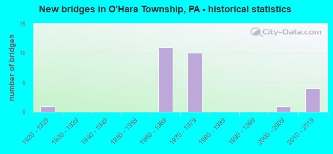
- New bridges - historical statistics
- 11920-1929
- 111960-1969
- 101970-1979
- 12000-2009
- 42010-2019

- Reconstructed bridges - Historical Statistics
- 21970-1979
- 01980-1989
- 71990-1999
- 02000-2009
- 12010-2019


- Bridge Condition - Deck
- 7.7%Excellent
- 15.4%Very good
- 23.1%Good
- 38.5%Satisfactory
- 15.4%Fair

- Bridge Condition - Superstructure
- 7.1%Excellent
- 14.3%Very good
- 14.3%Good
- 35.7%Satisfactory
- 28.6%Fair

- Bridge Condition - Substructure
- 21.4%Very good
- 7.1%Good
- 42.9%Satisfactory
- 28.6%Fair

- Bridge Condition - Channel
- 14.3%Very good
- 57.1%Good
- 14.3%Satisfactory
- 14.3%Fair
Find on map >> Show street view
Structure Number: 619, Location: AT ASPINWL.MAINT.SHED (Lat: 40.486667, Lng: -79.883333), Route carried "on" structure: State highway 28, Year Built: 1965, Year Reconstructed: 1984, Status: Open, Structure Length: 3.93m (12.89ft), Average Daily Traffic: 25,362 (year 2022), Truck Traffic: 6%, Average Future Daily Traffic: 30,905 (year 2032), Design Load: HS 20, Features Intersected: FOX CHAPEL ROAD
Minimum Vertical Clearance: 30+ m (98+ ft), Kilometerpoint: 12.022, Lanes on structure: 2, Lanes under structure: 3, Base Highway Network: Yes, Owner: State Highway Agency, Approaching Roadway Width: 10.4m (34.1ft), Skew: 3 degrees, Material/Design: Prestressed concrete, Design/Construction: Box Beam or Girders - Multiple, Number Of Spans In Main Unit: 1, Number Of Approach Spans: 2, Length of Maximum Span: 18.9m (62.0ft), Curb or Sidewalk Widths: Left: 0.2m (0.7ft), Right: 0.2m (0.7ft), Curb-To-Curb Width: 10.8m (35.4ft), Out-to-Out Width: 11.9m (39.0ft)
Condition: Deck: Satisfactory, Superstructure: Satisfactory, Substructure: Satisfactory, Inventory Rating: 68.9 metric tons, Method Used To Determine Inventory Rating: Load Factor (LF), Structural Evaluation: Equal to present minimum criteria, Deck Geometry: Meets minimum limits, Underclear: High priority of corrective action, Approach Roadway Alignment: Equal to present desirable criteria, Length Of Structure Improvement: 4.00m (13.12ft), Designated Inspection Frequency: Every 24 months, Inspection Date: June 2021, Bridge Improvement Cost: $8,000, Roadway Improvement Cost: $25,000, Total Project Cost: $107,000, Deck Structure Type: Concrete Cast-file-Place, Wearing Surface/Protective System: Wearing Surface: Monolithic Concrete, Deck Protection: Epoxy Coated Reinforcing
Find on map >> Show street view
Structure Number: 62, Location: AT BLAWNOX INTERCHANGE (Lat: 40.490681, Lng: -79.880133), Route carried "on" structure: State highway 28, Year Built: 1965, Year Reconstructed: 1984, Status: Open, Structure Length: 6.86m (22.51ft), Average Daily Traffic: 25,362 (year 2022), Truck Traffic: 6%, Average Future Daily Traffic: 30,905 (year 2032), Design Load: HS 20, Features Intersected: S.OAKHILL DR.& SQUAW RUN, Facility Carried by Structure: FREEPORT RD
Minimum Vertical Clearance: 30+ m (98+ ft), Kilometerpoint: 12.022, Lanes on structure: 2, Lanes under structure: 2, Base Highway Network: Yes, Owner: State Highway Agency, Approaching Roadway Width: 10.4m (34.1ft), Skew: 1 degrees, Material/Design: Steel, Design/Construction: Stringer/Multi-beam, Number Of Spans In Main Unit: 3, Length of Maximum Span: 24.7m (81.0ft), Curb or Sidewalk Widths: Left: 0.2m (0.7ft), Right: 0.2m (0.7ft), Curb-To-Curb Width: 10.8m (35.4ft), Out-to-Out Width: 11.9m (39.0ft)
Condition: Deck: Good, Superstructure: Fair, Substructure: Fair, Channel: Good, Operating Rating: 76.2 metric tons, Method Used To Determine Operating Rating: Load Factor (LF), Inventory Rating: 45.4 metric tons, Method Used To Determine Inventory Rating: Load Factor (LF), Structural Evaluation: Somewhat better than minimum adequacy, Deck Geometry: Meets minimum limits, Underclear: Meets minimum limits, Waterway Adequacy: Superior to present desirable criteria, Approach Roadway Alignment: Equal to present desirable criteria, Length Of Structure Improvement: 6.90m (22.64ft), Designated Inspection Frequency: Every 24 months, Inspection Date: June 2021, Bridge Improvement Cost: $35,000, Roadway Improvement Cost: $103,000, Total Project Cost: $473,000, Deck Structure Type: Concrete Cast-file-Place, Wearing Surface/Protective System: Wearing Surface: Monolithic Concrete, Deck Protection: Epoxy Coated Reinforcing
Find on map >> Show street view
Structure Number: 621, Location: AT PADOT ASPNWL. SHED (Lat: 40.490872, Lng: -79.882967), Route carried "on" structure: State highway 28, Year Built: 1965, Year Reconstructed: 2001, Status: Open, Structure Length: 3.96m (12.99ft), Average Daily Traffic: 25,581 (year 2022), Truck Traffic: 5%, Average Future Daily Traffic: 32,017 (year 2032), Design Load: HS 20, Features Intersected: FOX CHAPEL ROAD
Minimum Vertical Clearance: 30+ m (98+ ft), Kilometerpoint: 12.062, Lanes on structure: 3, Lanes under structure: 3, Base Highway Network: Yes, Owner: State Highway Agency, Approaching Roadway Width: 14.3m (46.9ft), Skew: 3 degrees, Material/Design: Prestressed concrete, Design/Construction: Box Beam or Girders - Multiple, Number Of Spans In Main Unit: 1, Number Of Approach Spans: 2, Length of Maximum Span: 18.9m (62.0ft), Curb or Sidewalk Widths: Left: 0.2m (0.7ft), Right: 0.2m (0.7ft), Curb-To-Curb Width: 14.5m (47.6ft), Out-to-Out Width: 15.5m (50.9ft)
Condition: Deck: Fair, Superstructure: Fair, Substructure: Fair, Operating Rating: 97.1 metric tons, Method Used To Determine Operating Rating: Load Factor (LF), Inventory Rating: 58.1 metric tons, Method Used To Determine Inventory Rating: Load Factor (LF), Structural Evaluation: Somewhat better than minimum adequacy, Deck Geometry: Meets minimum limits, Underclear: High priority of corrective action, Approach Roadway Alignment: Equal to present desirable criteria, Length Of Structure Improvement: 4.00m (13.12ft), Designated Inspection Frequency: Every 24 months, Inspection Date: June 2021, Deck Structure Type: Concrete Cast-file-Place, Wearing Surface/Protective System: Wearing Surface: Monolithic Concrete, Deck Protection: Epoxy Coated Reinforcing
Find on map >> Show street view
Structure Number: 622, Location: 600'N.OF FOX CHAPEL RD. (Lat: 40.490881, Lng: -79.880608), Route carried "on" structure: State highway 28, Year Built: 1965, Year Reconstructed: 2001, Status: Open, Structure Length: 7.01m (23.00ft), Average Daily Traffic: 25,581 (year 2022), Truck Traffic: 5%, Average Future Daily Traffic: 32,017 (year 2032), Design Load: HS 20, Features Intersected: S.OAKHILL DR.& SQUAW RUN, Facility Carried by Structure: FREEPORT RD
Minimum Vertical Clearance: 30+ m (98+ ft), Kilometerpoint: 12.062, Lanes on structure: 3, Lanes under structure: 2, Base Highway Network: Yes, Owner: State Highway Agency, Approaching Roadway Width: 14.3m (46.9ft), Skew: 11 degrees, Material/Design: Steel, Design/Construction: Stringer/Multi-beam, Number Of Spans In Main Unit: 3, Length of Maximum Span: 25.3m (83.0ft), Curb or Sidewalk Widths: Left: 0.2m (0.7ft), Right: 0.2m (0.7ft), Curb-To-Curb Width: 14.5m (47.6ft), Out-to-Out Width: 15.5m (50.9ft)
Condition: Deck: Fair, Superstructure: Satisfactory, Substructure: Satisfactory, Channel: Good, Operating Rating: 80.7 metric tons, Method Used To Determine Operating Rating: Load Factor (LF), Inventory Rating: 48.1 metric tons, Method Used To Determine Inventory Rating: Load Factor (LF), Structural Evaluation: Equal to present minimum criteria, Deck Geometry: Meets minimum limits, Underclear: Meets minimum limits, Waterway Adequacy: Superior to present desirable criteria, Approach Roadway Alignment: Equal to present desirable criteria, Length Of Structure Improvement: 7.00m (22.97ft), Designated Inspection Frequency: Every 24 months, Other Special Inspection Frequency: Every 6 months, Inspection Date: June 2021, Other Special Inspection Date: June 2021, Deck Structure Type: Concrete Cast-file-Place, Wearing Surface/Protective System: Wearing Surface: Monolithic Concrete, Deck Protection: Epoxy Coated Reinforcing
Find on map >> Show street view
Structure Number: 625, Location: R.I.D.C. INTERCHANGE (Lat: 40.501081, Lng: -79.862336), Route carried "on" structure: State highway 28, Year Built: 1970, Year Reconstructed: 2001, Status: Open, Structure Length: 5.33m (17.49ft), Average Daily Traffic: 19,394 (year 2020), Truck Traffic: 12%, Average Future Daily Traffic: 21,180 (year 2032), Design Load: HS 20, Features Intersected: GAMMA DRIVE (TWP RD 505)
Minimum Vertical Clearance: 30+ m (98+ ft), Kilometerpoint: 13.948, Lanes on structure: 2, Lanes under structure: 4, Base Highway Network: Yes, Owner: State Highway Agency, Approaching Roadway Width: 15.5m (50.9ft), Skew: 13 degrees, Material/Design: Prestressed concrete, Design/Construction: Stringer/Multi-beam, Number Of Spans In Main Unit: 3, Length of Maximum Span: 25.6m (84.0ft), Curb or Sidewalk Widths: Left: 0.2m (0.7ft), Right: 0.2m (0.7ft), Curb-To-Curb Width: 15.6m (51.2ft), Out-to-Out Width: 16.9m (55.4ft)
Condition: Deck: Satisfactory, Superstructure: Satisfactory, Substructure: Satisfactory, Operating Rating: 63.5 metric tons, Method Used To Determine Operating Rating: Load Factor (LF), Inventory Rating: 24.5 metric tons, Method Used To Determine Inventory Rating: Load Factor (LF), Structural Evaluation: Equal to present minimum criteria, Deck Geometry: Superior to present desirable criteria, Underclear: Equal to present minimum criteria, Approach Roadway Alignment: Equal to present desirable criteria, Length Of Structure Improvement: 5.30m (17.39ft), Designated Inspection Frequency: Every 24 months, Inspection Date: June 2021, Bridge Improvement Cost: $38,000, Roadway Improvement Cost: $111,000, Total Project Cost: $508,000, Deck Structure Type: Concrete Cast-file-Place, Wearing Surface/Protective System: Wearing Surface: Latex Concrete
Find on map >> Show street view
Structure Number: 626, Location: RIDC INTERCHANGE (Lat: 40.501111, Lng: -79.862653), Route carried "on" structure: State highway 28, Year Built: 1970, Year Reconstructed: 2001, Status: Open, Structure Length: 5.70m (18.70ft), Average Daily Traffic: 19,576 (year 2020), Truck Traffic: 13%, Average Future Daily Traffic: 20,362 (year 2032), Design Load: HS 20, Features Intersected: GAMMA DRIVE (TWP RD 505)
Minimum Vertical Clearance: 30+ m (98+ ft), Kilometerpoint: 13.916, Lanes on structure: 2, Lanes under structure: 4, Base Highway Network: Yes, Owner: State Highway Agency, Approaching Roadway Width: 12.8m (42.0ft), Skew: 13 degrees, Material/Design: Prestressed concrete, Design/Construction: Stringer/Multi-beam, Number Of Spans In Main Unit: 3, Length of Maximum Span: 27.7m (90.9ft), Curb or Sidewalk Widths: Left: 0.2m (0.7ft), Right: 0.2m (0.7ft), Curb-To-Curb Width: 12.0m (39.4ft), Out-to-Out Width: 13.2m (43.3ft)
Condition: Deck: Satisfactory, Superstructure: Satisfactory, Substructure: Satisfactory, Operating Rating: 81.6 metric tons, Method Used To Determine Operating Rating: Load Factor (LF), Inventory Rating: 30.8 metric tons, Method Used To Determine Inventory Rating: Load Factor (LF), Structural Evaluation: Equal to present minimum criteria, Deck Geometry: Equal to present minimum criteria, Underclear: Better than present minimum criteria, Approach Roadway Alignment: Equal to present desirable criteria, Length Of Structure Improvement: 5.70m (18.70ft), Designated Inspection Frequency: Every 24 months, Inspection Date: June 2021, Deck Structure Type: Concrete Cast-file-Place, Wearing Surface/Protective System: Wearing Surface: Other
Find on map >> Show street view
Structure Number: 627, Location: 1037 NB OVER LR 02146 (Lat: 40.509231, Lng: -79.855378), Route carried "on" structure: State highway 28, Year Built: 1970, Year Reconstructed: 2001, Status: Open, Structure Length: 7.38m (24.21ft), Average Daily Traffic: 19,394 (year 2020), Truck Traffic: 12%, Average Future Daily Traffic: 21,180 (year 2032), Design Load: HS 20, Features Intersected: POWERS RUN ROAD SR 1009
Minimum Vertical Clearance: 30+ m (98+ ft), Kilometerpoint: 15.768, Lanes on structure: 2, Lanes under structure: 2, Base Highway Network: Yes, Owner: State Highway Agency, Approaching Roadway Width: 12.2m (40.0ft), Skew: 13 degrees, Material/Design: Prestressed concrete, Design/Construction: Stringer/Multi-beam, Number Of Spans In Main Unit: 3, Length of Maximum Span: 25.0m (82.0ft), Curb or Sidewalk Widths: Left: 0.2m (0.7ft), Right: 0.2m (0.7ft), Curb-To-Curb Width: 11.7m (38.4ft), Out-to-Out Width: 13.0m (42.7ft)
Condition: Deck: Satisfactory, Superstructure: Fair, Substructure: Satisfactory, Operating Rating: 79.8 metric tons, Method Used To Determine Operating Rating: Load Factor (LF), Inventory Rating: 24.5 metric tons, Method Used To Determine Inventory Rating: Load Factor (LF), Structural Evaluation: Somewhat better than minimum adequacy, Deck Geometry: Equal to present minimum criteria, Underclear: Meets minimum limits, Approach Roadway Alignment: Equal to present desirable criteria, Length Of Structure Improvement: 7.40m (24.28ft), Designated Inspection Frequency: Every 24 months, Inspection Date: June 2021, Deck Structure Type: Concrete Cast-file-Place, Wearing Surface/Protective System: Wearing Surface: Other
Find on map >> Show street view
Structure Number: 628, Location: 1037 SB OVER LR 02146 (Lat: 40.509581, Lng: -79.855428), Route carried "on" structure: State highway 28, Year Built: 1970, Year Reconstructed: 2001, Status: Open, Structure Length: 5.55m (18.21ft), Average Daily Traffic: 19,576 (year 2020), Truck Traffic: 13%, Average Future Daily Traffic: 20,362 (year 2032), Design Load: HS 20, Features Intersected: POWERS RUN ROAD SR 1009
Minimum Vertical Clearance: 30+ m (98+ ft), Kilometerpoint: 15.755, Lanes on structure: 2, Lanes under structure: 2, Base Highway Network: Yes, Owner: State Highway Agency, Approaching Roadway Width: 15.2m (49.9ft), Skew: 12 degrees, Material/Design: Prestressed concrete, Design/Construction: Stringer/Multi-beam, Number Of Spans In Main Unit: 3, Length of Maximum Span: 18.9m (62.0ft), Curb or Sidewalk Widths: Left: 0.2m (0.7ft), Right: 0.2m (0.7ft), Curb-To-Curb Width: 15.4m (50.5ft), Out-to-Out Width: 16.6m (54.5ft)
Condition: Deck: Satisfactory, Superstructure: Fair, Substructure: Fair, Operating Rating: 82.6 metric tons, Method Used To Determine Operating Rating: Load Factor (LF), Inventory Rating: 24.5 metric tons, Method Used To Determine Inventory Rating: Load Factor (LF), Structural Evaluation: Somewhat better than minimum adequacy, Deck Geometry: Superior to present desirable criteria, Underclear: Meets minimum limits, Approach Roadway Alignment: Better than present minimum criteria, Length Of Structure Improvement: 5.50m (18.04ft), Designated Inspection Frequency: Every 24 months, Inspection Date: June 2021, Deck Structure Type: Concrete Cast-file-Place, Wearing Surface/Protective System: Wearing Surface: Other
Find on map >> Show street view
Structure Number: 1358, Location: NEAR HIGHLAND PARK BRIDGE (Lat: 40.493153, Lng: -79.911994), Route carried "on" structure: State highway , Year Built: 1927, Year Reconstructed: 2018, Status: Open, Structure Length: 2.59m (8.50ft), Average Daily Traffic: 7,167 (year 2020), Truck Traffic: 2%, Average Future Daily Traffic: 13,916 (year 2032), Design Load: HL 93, Features Intersected: NORFOLK SOUTHERN RR, Facility Carried by Structure: FREEPORT ROAD
Minimum Vertical Clearance: 30+ m (98+ ft), Kilometerpoint: 3.351, Lanes on structure: 2, Owner: State Highway Agency, Approaching Roadway Width: 14.0m (45.9ft), Skew: 5 degrees, Material/Design: Prestressed concrete, Design/Construction: Stringer/Multi-beam, Number Of Spans In Main Unit: 1, Length of Maximum Span: 24.1m (79.1ft), Curb or Sidewalk Widths: Left: 1.7m (5.6ft), Right: 0.0m, Curb-To-Curb Width: 14.0m (45.9ft), Out-to-Out Width: 16.8m (55.1ft)
Condition: Deck: Very good, Superstructure: Very good, Substructure: Satisfactory, Operating Rating: 49.9 metric tons, Method Used To Determine Operating Rating: Assigned ratings based on Load and Resistance Factor Design (LRFD) reported by rating factor (RF) using HL93 loadings, Inventory Rating: 38.6 metric tons, Method Used To Determine Inventory Rating: Assigned ratings based on Load and Resistance Factor Design (LRFD) reported by rating factor (RF) using HL93 loadings, Structural Evaluation: Equal to present minimum criteria, Deck Geometry: Superior to present desirable criteria, Underclear: High priority of replacement, Approach Roadway Alignment: Somewhat better than minimum adequacy, Length Of Structure Improvement: 4.10m (13.45ft), Designated Inspection Frequency: Every 24 months, Inspection Date: September 2021, Bridge Improvement Cost: $104,000, Roadway Improvement Cost: $305,000, Total Project Cost: $1,399,000, Deck Structure Type: Concrete Cast-file-Place, Wearing Surface/Protective System: Wearing Surface: Monolithic Concrete, Deck Protection: Epoxy Coated Reinforcing
Find on map >> Show street view
Structure Number: 1377, Location: @ INT W/ SR 28 & FREEPORT (Lat: 40.490469, Lng: -79.871753), Route carried "on" structure: State highway , Year Built: 1965, Year Reconstructed: 1995, Status: Open, Structure Length: 4.72m (15.49ft), Average Daily Traffic: 8,340 (year 2022), Truck Traffic: 2%, Average Future Daily Traffic: 9,764 (year 2032), Design Load: HS 20, Features Intersected: SR 9108, Facility Carried by Structure: SR 1002
Minimum Vertical Clearance: 30+ m (98+ ft), Kilometerpoint: 0.480, Lanes on structure: 4, Lanes under structure: 2, Owner: State Highway Agency, Approaching Roadway Width: 23.2m (76.1ft), Skew: 34 degrees, Material/Design: Prestressed concrete, Design/Construction: Box Beam or Girders - Single/Spread, Number Of Spans In Main Unit: 3, Length of Maximum Span: 16.8m (55.1ft), Curb or Sidewalk Widths: Left: 0.2m (0.7ft), Right: 0.2m (0.7ft), Curb-To-Curb Width: 20.7m (67.9ft), Out-to-Out Width: 21.6m (70.9ft)
Condition: Deck: Good, Superstructure: Satisfactory, Substructure: Fair, Operating Rating: 66.2 metric tons, Method Used To Determine Operating Rating: Load Factor (LF), Inventory Rating: 39.9 metric tons, Method Used To Determine Inventory Rating: Load Factor (LF), Structural Evaluation: Somewhat better than minimum adequacy, Deck Geometry: Superior to present desirable criteria, Underclear: Equal to present minimum criteria, Approach Roadway Alignment: Equal to present desirable criteria, Length Of Structure Improvement: 4.70m (15.42ft), Designated Inspection Frequency: Every 24 months, Inspection Date: January 2021, Deck Structure Type: Concrete Cast-file-Place, Wearing Surface/Protective System: Wearing Surface: Monolithic Concrete, Deck Protection: Epoxy Coated Reinforcing
Find on map >> Show street view
Structure Number: 4585, Location: 1.3 Mi. SW of Glenshaw (Lat: 40.525297, Lng: -79.927656), Route carried "on" structure: City street , Year Built: 2010, Status: Open, Structure Length: 1.22m (4.00ft), Average Daily Traffic: 100 (year 2018), Truck Traffic: 5%, Average Future Daily Traffic: 110 (year 2039), Design Load: HL 93, Features Intersected: East Little Pine Creek, Facility Carried by Structure: Calmwood Drive
Minimum Vertical Clearance: 30+ m (98+ ft), Kilometerpoint: 0.000, Lanes on structure: 1, Owner: Town or Township Highway Agency, Approaching Roadway Width: 7.0m (23.0ft), Skew: 1 degrees, Material/Design: Prestressed concrete, Design/Construction: Box Beam or Girders - Multiple, Number Of Spans In Main Unit: 1, Length of Maximum Span: 11.6m (38.1ft), Curb or Sidewalk Widths: Left: 0.2m (0.7ft), Right: 0.2m (0.7ft), Curb-To-Curb Width: 4.5m (14.8ft), Out-to-Out Width: 5.6m (18.4ft)
Condition: Deck: Good, Superstructure: Good, Substructure: Good, Channel: Fair, Operating Rating: 70.8 metric tons, Method Used To Determine Operating Rating: Load and Resistance Factor (LRFR), Inventory Rating: 47.2 metric tons, Method Used To Determine Inventory Rating: Load and Resistance Factor (LRFR), Structural Evaluation: Better than present minimum criteria, Deck Geometry: Equal to present minimum criteria, Waterway Adequacy: Better than present minimum criteria, Approach Roadway Alignment: Equal to present minimum criteria, Designated Inspection Frequency: Every 24 months, Inspection Date: March 2020, Deck Structure Type: Concrete Cast-file-Place, Wearing Surface/Protective System: Wearing Surface: Monolithic Concrete, Deck Protection: Epoxy Coated Reinforcing
Find on map >> Show street view
Structure Number: 47018, Location: Off Old Freeport Rd (Lat: 40.487292, Lng: -79.877483), Route carried "on" structure: City street , Year Built: 2004, Status: Open, Structure Length: 0.79m (2.59ft), Average Daily Traffic: 300 (year 2018), Truck Traffic: 1%, Average Future Daily Traffic: 325 (year 2039), Design Load: HL 93, Features Intersected: Squaw Run, Facility Carried by Structure: Zaenger Drive
Minimum Vertical Clearance: 30+ m (98+ ft), Kilometerpoint: 0.000, Lanes on structure: 2, Owner: Town or Township Highway Agency, Approaching Roadway Width: 7.9m (25.9ft), Material/Design: Concrete, Design/Construction: Culvert, Number Of Spans In Main Unit: 1, Length of Maximum Span: 7.3m (24.0ft)
Condition: Channel: Good, Culverts: Good, Operating Rating: 68.9 metric tons, Method Used To Determine Operating Rating: Load Factor (LF), Inventory Rating: 43.5 metric tons, Method Used To Determine Inventory Rating: Load Factor (LF), Structural Evaluation: Better than present minimum criteria, Waterway Adequacy: Better than present minimum criteria, Approach Roadway Alignment: Equal to present desirable criteria, Designated Inspection Frequency: Every 24 months, Inspection Date: Febuary 2020
Find on map >> Show street view
Structure Number: 53269, Location: 1 MI. N.E. of SR 0008 (Lat: 40.523056, Lng: -79.935922), Route carried "on" structure: State highway , Year Built: 2016, Status: Open, Structure Length: 1.58m (5.18ft), Average Daily Traffic: 2,094 (year 2022), Truck Traffic: 1%, Average Future Daily Traffic: 9,680 (year 2037), Design Load: HL 93, Features Intersected: Little Pine Creek, Facility Carried by Structure: SAXONBURG BLVD
Minimum Vertical Clearance: 30+ m (98+ ft), Kilometerpoint: 1.513, Lanes on structure: 2, Owner: State Highway Agency, Maintenance Responsibility: Private, Approaching Roadway Width: 9.1m (29.9ft), Skew: 3 degrees, Material/Design: Prestressed concrete, Design/Construction: Box Beam or Girders - Single/Spread, Number Of Spans In Main Unit: 1, Length of Maximum Span: 14.6m (47.9ft), Curb-To-Curb Width: 9.1m (29.9ft), Out-to-Out Width: 9.8m (32.2ft)
Condition: Deck: Excellent, Superstructure: Excellent, Substructure: Very good, Channel: Very good, Operating Rating: 61.2 metric tons, Method Used To Determine Operating Rating: Assigned ratings based on Load and Resistance Factor Design (LRFD) reported by rating factor (RF) using HL93 loadings, Inventory Rating: 47.3 metric tons, Method Used To Determine Inventory Rating: Assigned ratings based on Load and Resistance Factor Design (LRFD) reported by rating factor (RF) using HL93 loadings, Structural Evaluation: Equal to present desirable criteria, Deck Geometry: Meets minimum limits, Waterway Adequacy: Equal to present desirable criteria, Approach Roadway Alignment: Equal to present desirable criteria, Designated Inspection Frequency: Every 24 months, Inspection Date: July 2020, Deck Structure Type: Concrete Cast-file-Place, Wearing Surface/Protective System: Wearing Surface: Integral Concrete, Deck Protection: Epoxy Coated Reinforcing
Find on map >> Show street view
Structure Number: 5426, Location: 1/2 mi. S of SR 1002 (Lat: 40.488425, Lng: -79.878344), Route carried "on" structure: State highway , Year Built: 2018, Status: Open, Structure Length: 1.55m (5.09ft), Average Daily Traffic: 9,984 (year 2022), Truck Traffic: 3%, Average Future Daily Traffic: 15,862 (year 2032), Design Load: HL 93, Features Intersected: Squaw Run, Facility Carried by Structure: Freeport Road
Minimum Vertical Clearance: 30+ m (98+ ft), Kilometerpoint: 6.610, Lanes on structure: 2, Owner: State Highway Agency, Approaching Roadway Width: 12.2m (40.0ft), Skew: 3 degrees, Design/Construction: Arch - Deck, Number Of Spans In Main Unit: 1, Length of Maximum Span: 13.7m (44.9ft), Curb-To-Curb Width: 12.2m (40.0ft), Out-to-Out Width: 13.1m (43.0ft)
Condition: Superstructure: Very good, Substructure: Very good, Channel: Satisfactory, Operating Rating: 44.7 metric tons, Method Used To Determine Operating Rating: Assigned ratings based on Load and Resistance Factor Design (LRFD) reported by rating factor (RF) using HL93 loadings, Inventory Rating: 34.3 metric tons, Method Used To Determine Inventory Rating: Assigned ratings based on Load and Resistance Factor Design (LRFD) reported by rating factor (RF) using HL93 loadings, Structural Evaluation: Equal to present desirable criteria, Deck Geometry: Somewhat better than minimum adequacy, Waterway Adequacy: Superior to present desirable criteria, Approach Roadway Alignment: Equal to present desirable criteria, Designated Inspection Frequency: Every 24 months, Inspection Date: December 2020
Find on map >> Show street view
Structure Number: 5707, Location: 112001 O'HARA TWP (Lat: 40.530539, Lng: -79.923194), Route carried "on" structure: City street , Year Built: 2019, Status: Open, Structure Length: 1.13m (3.71ft), Average Daily Traffic: 1,765 (year 2019), Truck Traffic: 24%, Average Future Daily Traffic: 1,977 (year 2039), Design Load: HS 20, Features Intersected: Little Pine Creek, Facility Carried by Structure: Brownshill Road
Minimum Vertical Clearance: 30+ m (98+ ft), Kilometerpoint: 0.000, Lanes on structure: 2, Owner: Town or Township Highway Agency, Approaching Roadway Width: 9.1m (29.9ft), Skew: 1 degrees, Material/Design: Prestressed concrete, Design/Construction: Box Beam or Girders - Single/Spread, Number Of Spans In Main Unit: 1, Length of Maximum Span: 11.0m (36.1ft), Curb or Sidewalk Widths: Left: 0.2m (0.7ft), Right: 0.2m (0.7ft), Curb-To-Curb Width: 8.8m (28.9ft), Out-to-Out Width: 9.9m (32.5ft)
Condition: Deck: Very good, Superstructure: Good, Substructure: Very good, Channel: Good, Operating Rating: 78.9 metric tons, Method Used To Determine Operating Rating: Load and Resistance Factor (LRFR), Inventory Rating: 54.4 metric tons, Method Used To Determine Inventory Rating: Load and Resistance Factor (LRFR), Structural Evaluation: Better than present minimum criteria, Deck Geometry: Somewhat better than minimum adequacy, Waterway Adequacy: Equal to present desirable criteria, Approach Roadway Alignment: Equal to present desirable criteria, Designated Inspection Frequency: Every 24 months, Inspection Date: September 2021, Deck Structure Type: Concrete Cast-file-Place, Wearing Surface/Protective System: Wearing Surface: Monolithic Concrete, Deck Protection: Epoxy Coated Reinforcing
Find on map >> Show street view
Structure Number: 619, Location: AT ASPINWL.MAINT.SHED (Lat: 40.486667, Lng: -79.883333), Route carried "under" structure: County highway , Year Built: 1965, Structure Length: 0. m, Average Daily Traffic: 1 (year 2003), Truck Traffic: 1%, Features Intersected: FOX CHAPEL ROAD, Facility Carried by Structure: SR 0028 NB
Minimum Vertical Clearance: 5.43m (17.81ft), Kilometerpoint: 0.000, Lanes on structure: 2, Lanes under structure: 3, Material/Design: Prestressed concrete, Design/Construction: Box Beam or Girders - Multiple, Length of Maximum Span: 18.9m (62.0ft)
Find on map >> Show street view
Structure Number: 62, Location: AT BLAWNOX INTERCHANGE (Lat: 40.490681, Lng: -79.880133), Route carried "under" structure: City street , Year Built: 1965, Structure Length: 0. m, Average Daily Traffic: 1,000 (year 2005), Truck Traffic: 2%, Features Intersected: S.OAKHILL DR.& SQUAW RUN, Facility Carried by Structure: FREEPORT RD
Minimum Vertical Clearance: 4.37m (14.34ft), Kilometerpoint: 0.000, Lanes on structure: 2, Lanes under structure: 2, Material/Design: Steel, Design/Construction: Stringer/Multi-beam, Length of Maximum Span: 24.7m (81.0ft)
Find on map >> Show street view
Structure Number: 621, Location: AT PADOT ASPNWL. SHED (Lat: 40.490872, Lng: -79.882967), Route carried "under" structure: County highway , Year Built: 1965, Structure Length: 0. m, Average Daily Traffic: 1 (year 2004), Truck Traffic: 1%, Features Intersected: FOX CHAPEL ROAD, Facility Carried by Structure: SR 0028 SB
Minimum Vertical Clearance: 4.55m (14.93ft), Kilometerpoint: 0.000, Lanes on structure: 3, Lanes under structure: 3, Material/Design: Prestressed concrete, Design/Construction: Box Beam or Girders - Multiple, Length of Maximum Span: 18.9m (62.0ft)
Find on map >> Show street view
Structure Number: 622, Location: 600'N.OF FOX CHAPEL RD. (Lat: 40.490881, Lng: -79.880608), Route carried "under" structure: City street , Year Built: 1965, Structure Length: 0. m, Average Daily Traffic: 200 (year 2005), Truck Traffic: 1%, Features Intersected: S.OAKHILL DR.& SQUAW RUN, Facility Carried by Structure: FREEPORT RD
Minimum Vertical Clearance: 4.58m (15.03ft), Kilometerpoint: 0.000, Lanes on structure: 3, Lanes under structure: 2, Material/Design: Steel, Design/Construction: Stringer/Multi-beam, Length of Maximum Span: 25.3m (83.0ft)
Find on map >> Show street view
Structure Number: 624, Location: TWP.RD 503 OVER SR 0028 (Lat: 40.491667, Lng: -79.875000), Route carried "under" structure: State highway 28, Year Built: 1970, Structure Length: 0. m, Average Daily Traffic: 24,773 (year 2022), Truck Traffic: 5%, Features Intersected: SR 0028 NB SB, Facility Carried by Structure: ALPHA DR
Minimum Vertical Clearance: 4.65m (15.26ft), Kilometerpoint: 13.948, Lanes on structure: 4, Lanes under structure: 5, Material/Design: Prestressed concrete, Design/Construction: Stringer/Multi-beam, Length of Maximum Span: 23.8m (78.1ft)
Find on map >> Show street view
Structure Number: 624, Location: TWP.RD 503 OVER SR 0028 (Lat: 40.491667, Lng: -79.875000), Route carried "under" structure: State highway 28, Year Built: 1970, Structure Length: 0. m, Average Daily Traffic: 24,015 (year 2022), Truck Traffic: 5%, Features Intersected: SR 0028 NB SB, Facility Carried by Structure: ALPHA DR
Minimum Vertical Clearance: 4.65m (15.26ft), Kilometerpoint: 13.916, Lanes on structure: 4, Lanes under structure: 5, Material/Design: Prestressed concrete, Design/Construction: Stringer/Multi-beam, Length of Maximum Span: 23.8m (78.1ft)
Find on map >> Show street view
Structure Number: 625, Location: R.I.D.C. INTERCHANGE (Lat: 40.501081, Lng: -79.862336), Route carried "under" structure: City street , Year Built: 1970, Structure Length: 0. m, Average Daily Traffic: 1,600 (year 2005), Truck Traffic: 2%, Features Intersected: GAMMA DRIVE (TWP RD 505), Facility Carried by Structure: SR 0028 SB
Minimum Vertical Clearance: 4.57m (14.99ft), Kilometerpoint: 0.000, Lanes on structure: 2, Lanes under structure: 4, Material/Design: Prestressed concrete, Design/Construction: Stringer/Multi-beam, Length of Maximum Span: 25.6m (84.0ft)
Find on map >> Show street view
Structure Number: 626, Location: RIDC INTERCHANGE (Lat: 40.501111, Lng: -79.862653), Route carried "under" structure: City street , Year Built: 1970, Structure Length: 0. m, Average Daily Traffic: 1,600 (year 2005), Truck Traffic: 2%, Features Intersected: GAMMA DRIVE (TWP RD 505), Facility Carried by Structure: SR 0028 SH
Minimum Vertical Clearance: 4.90m (16.08ft), Kilometerpoint: 0.000, Lanes on structure: 2, Lanes under structure: 4, Material/Design: Prestressed concrete, Design/Construction: Stringer/Multi-beam, Length of Maximum Span: 27.7m (90.9ft)
Find on map >> Show street view
Structure Number: 627, Location: 1037 NB OVER LR 02146 (Lat: 40.509231, Lng: -79.855378), Route carried "under" structure: State highway , Year Built: 1970, Structure Length: 0. m, Average Daily Traffic: 3,847 (year 2020), Truck Traffic: 1%, Features Intersected: POWERS RUN ROAD SR 1009, Facility Carried by Structure: SR 0028 NB
Minimum Vertical Clearance: 7.47m (24.51ft), Kilometerpoint: 0.431, Lanes on structure: 2, Lanes under structure: 2, Material/Design: Prestressed concrete, Design/Construction: Stringer/Multi-beam, Length of Maximum Span: 25.0m (82.0ft)
Find on map >> Show street view
Structure Number: 628, Location: 1037 SB OVER LR 02146 (Lat: 40.509581, Lng: -79.855428), Route carried "under" structure: State highway , Year Built: 1970, Structure Length: 0. m, Average Daily Traffic: 3,847 (year 2020), Truck Traffic: 1%, Features Intersected: POWERS RUN ROAD SR 1009, Facility Carried by Structure: SR 0028 SB
Minimum Vertical Clearance: 4.57m (14.99ft), Kilometerpoint: 0.431, Lanes on structure: 2, Lanes under structure: 2, Material/Design: Prestressed concrete, Design/Construction: Stringer/Multi-beam, Length of Maximum Span: 18.9m (62.0ft)
Find on map >> Show street view
Structure Number: 1376, Location: 70 PAR S.B.OVER 1037 N.B. (Lat: 40.490800, Lng: -79.875703), Route carried "under" structure: State highway 28, Year Built: 1965, Structure Length: 0. m, Average Daily Traffic: 24,773 (year 2022), Truck Traffic: 5%, Features Intersected: LR 1037 NB.-TR 28, Facility Carried by Structure: FREEPORT RD RP
Minimum Vertical Clearance: 4.62m (15.16ft), Kilometerpoint: 12.863, Lanes on structure: 1, Lanes under structure: 2, Material/Design: Steel, Design/Construction: Stringer/Multi-beam, Length of Maximum Span: 26.5m (86.9ft)
Find on map >> Show street view
Structure Number: 1377, Location: @ INT W/ SR 28 & FREEPORT (Lat: 40.490469, Lng: -79.871753), Route carried "under" structure: State highway , Year Built: 1965, Structure Length: 0. m, Average Daily Traffic: 4,322 (year 2022), Truck Traffic: 7%, Features Intersected: SR 9108, Facility Carried by Structure: SR 1002
Minimum Vertical Clearance: 4.45m (14.60ft), Kilometerpoint: 0.000, Lanes on structure: 4, Lanes under structure: 2, Material/Design: Prestressed concrete, Design/Construction: Box Beam or Girders - Single/Spread, Length of Maximum Span: 16.8m (55.1ft)