Bridge Statistics for Northbrook, Illinois (IL)
Condition, Traffic, Stress, Structural Evaluation, Project Costs
- National Bridge Inventory (NBI) Statistics
- 44Number of bridges
- 456ft / 139mTotal length
- $988,000Total costs
- 1,359,050Total average daily traffic
- 125,015Total average daily truck traffic
- National Bridge Inventory (NBI) Registered Bridges for Northbrook
- No street view available for this location
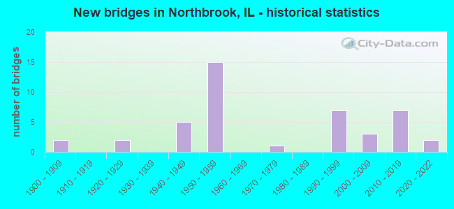
- New bridges - historical statistics
- 21900-1909
- 21920-1929
- 51940-1949
- 151950-1959
- 11970-1979
- 71990-1999
- 32000-2009
- 72010-2019
- 22020-2022

- Reconstructed bridges - Historical Statistics
- 21960-1969
- 21970-1979
- 11980-1989
- 11990-1999
- 22000-2009
- 12010-2019


- Bridge Condition - Deck
- 3.7%Excellent
- 37.0%Very good
- 11.1%Good
- 33.3%Satisfactory
- 14.8%Fair

- Bridge Condition - Superstructure
- 3.4%Excellent
- 48.3%Very good
- 17.2%Good
- 17.2%Satisfactory
- 6.9%Fair
- 6.9%Poor

- Bridge Condition - Substructure
- 31.0%Very good
- 55.2%Good
- 3.4%Satisfactory
- 10.3%Fair

- Bridge Condition - Channel
- 66.7%Good
- 26.7%Satisfactory
- 6.7%Fair
Find on map >> Show street view
Structure Number: 160527, Location: 1 M E US 45 (Lat: 42.138553, Lng: -87.887469), Route carried "on" structure: State highway 68, Year Built: 1958, Year Reconstructed: 1999, Status: Open, Structure Length: 6.96m (22.83ft), Average Daily Traffic: 21,600 (year 2021), Truck Traffic: 5%, Average Future Daily Traffic: 33,372 (year 2032), Design Load: HS 20, Features Intersected: I-294 TRI STATE TOLL
Minimum Vertical Clearance: 30+ m (98+ ft), Kilometerpoint: 32.958, Lanes on structure: 4, Lanes under structure: 4, Base Highway Network: Yes, Owner: State Highway Agency, Approaching Roadway Width: 18.2m (59.7ft), Material/Design: Prestressed concrete continuous, Design/Construction: Stringer/Multi-beam, Number Of Spans In Main Unit: 4, Length of Maximum Span: 20.1m (65.9ft), Curb or Sidewalk Widths: Left: 1.5m (4.9ft), Right: 1.5m (4.9ft), Curb-To-Curb Width: 18.2m (59.7ft), Out-to-Out Width: 21.8m (71.5ft)
Condition: Deck: Fair, Superstructure: Satisfactory, Substructure: Fair, Operating Rating: 71.6 metric tons, Method Used To Determine Operating Rating: Load Factor (LF) rating reported by rating factor (RF) method using MS18 loading, Inventory Rating: 43.1 metric tons, Method Used To Determine Inventory Rating: Load Factor (LF) rating reported by rating factor (RF) method using MS18 loading, Structural Evaluation: Somewhat better than minimum adequacy, Deck Geometry: Somewhat better than minimum adequacy, Underclear: High priority of corrective action, Approach Roadway Alignment: Equal to present desirable criteria, Designated Inspection Frequency: Every 24 months, Inspection Date: May 2019, Deck Structure Type: Concrete Cast-file-Place, Wearing Surface/Protective System: Deck Protection: Epoxy Coated Reinforcing
Find on map >> Show street view
Structure Number: 160528, Location: 0.5 M W ILL 43 (Lat: 42.138256, Lng: -87.835353), Route carried "on" structure: State highway 68, Year Built: 1957, Year Reconstructed: 1970, Status: Open, Structure Length: 1.28m (4.20ft), Average Daily Traffic: 23,000 (year 2021), Truck Traffic: 3%, Average Future Daily Traffic: 36,668 (year 2032), Design Load: HS 20, Features Intersected: W F N BR CHICAGO RIV
Minimum Vertical Clearance: 30+ m (98+ ft), Kilometerpoint: 37.287, Lanes on structure: 4, Base Highway Network: Yes, Owner: State Highway Agency, Approaching Roadway Width: 16.8m (55.1ft), Skew: 30 degrees, Material/Design: Steel, Design/Construction: Stringer/Multi-beam, Number Of Spans In Main Unit: 1, Length of Maximum Span: 12.2m (40.0ft), Curb or Sidewalk Widths: Left: 1.5m (4.9ft), Right: 1.5m (4.9ft), Curb-To-Curb Width: 15.8m (51.8ft), Out-to-Out Width: 21.8m (71.5ft)
Condition: Deck: Fair, Superstructure: Fair, Substructure: Good, Channel: Satisfactory, Operating Rating: 83.9 metric tons, Method Used To Determine Operating Rating: Load Factor (LF) rating reported by rating factor (RF) method using MS18 loading, Inventory Rating: 44.7 metric tons, Method Used To Determine Inventory Rating: Load Factor (LF) rating reported by rating factor (RF) method using MS18 loading, Structural Evaluation: Somewhat better than minimum adequacy, Deck Geometry: Meets minimum limits, Waterway Adequacy: Equal to present desirable criteria, Approach Roadway Alignment: Equal to present desirable criteria, Designated Inspection Frequency: Every 24 months, Other Special Inspection Frequency: Every 24 months, Inspection Date: September 2021, Other Special Inspection Date: September 2021, Deck Structure Type: Concrete Cast-file-Place, Wearing Surface/Protective System: Wearing Surface: Integral Concrete
Find on map >> Show street view
Structure Number: 160534, Location: 1.3 M W IL 43 (Lat: 42.105444, Lng: -87.810728), Route carried "on" structure: Other road , Year Built: 1941, Year Reconstructed: 1969, Status: Open, Structure Length: 1.62m (5.31ft), Average Daily Traffic: 35,600 (year 2021), Truck Traffic: 7%, Average Future Daily Traffic: 38,831 (year 2032), Features Intersected: W F N BR CHICAGO RIV, Facility Carried by Structure: WILLOW RD
Minimum Vertical Clearance: 30+ m (98+ ft), Kilometerpoint: 28.565, Lanes on structure: 4, Base Highway Network: Yes, Owner: State Highway Agency, Approaching Roadway Width: 16.5m (54.1ft), Skew: 30 degrees, Material/Design: Concrete, Design/Construction: Tee Beam, Number Of Spans In Main Unit: 1, Length of Maximum Span: 15.5m (50.9ft), Curb or Sidewalk Widths: Left: 1.5m (4.9ft), Right: 1.5m (4.9ft), Curb-To-Curb Width: 16.5m (54.1ft), Out-to-Out Width: 23.6m (77.4ft)
Condition: Deck: Fair, Superstructure: Poor, Substructure: Fair, Channel: Good, Operating Rating: 45.0 metric tons, Method Used To Determine Operating Rating: Load Factor (LF) rating reported by rating factor (RF) method using MS18 loading, Inventory Rating: 26.9 metric tons, Method Used To Determine Inventory Rating: Load Factor (LF) rating reported by rating factor (RF) method using MS18 loading, Structural Evaluation: Meets minimum limits, Deck Geometry: Meets minimum limits, Waterway Adequacy: Equal to present desirable criteria, Approach Roadway Alignment: Equal to present desirable criteria, Designated Inspection Frequency: Every 12 months, Inspection Date: October 2021, Deck Structure Type: Concrete Cast-file-Place, Wearing Surface/Protective System: Wearing Surface: Bituminous
Find on map >> Show street view
Structure Number: 160811, Location: 1.2 M N IL 68 (Lat: 42.152464, Lng: -87.799014), Route carried "on" structure: Other road , Year Built: 1950, Year Reconstructed: 1982, Status: Open, Structure Length: 7.04m (23.10ft), Average Daily Traffic: 31,500 (year 2018), Truck Traffic: 2%, Average Future Daily Traffic: 34,917 (year 2032), Design Load: HS 20, Features Intersected: US 41 EDENS, Facility Carried by Structure: LAKE COOK RD
Minimum Vertical Clearance: 30+ m (98+ ft), Kilometerpoint: 19.923, Lanes on structure: 6, Lanes under structure: 6, Base Highway Network: Yes, Owner: State Highway Agency, Approaching Roadway Width: 18.3m (60.0ft), Skew: 30 degrees, Material/Design: Steel continuous, Design/Construction: Stringer/Multi-beam, Number Of Spans In Main Unit: 4, Length of Maximum Span: 18.9m (62.0ft), Curb or Sidewalk Widths: Left: 1.5m (4.9ft), Right: 1.5m (4.9ft), Curb-To-Curb Width: 22.6m (74.1ft), Out-to-Out Width: 28.0m (91.9ft)
Condition: Deck: Satisfactory, Superstructure: Satisfactory, Substructure: Good, Operating Rating: 65.8 metric tons, Method Used To Determine Operating Rating: Load Factor (LF) rating reported by rating factor (RF) method using MS18 loading, Inventory Rating: 39.5 metric tons, Method Used To Determine Inventory Rating: Load Factor (LF) rating reported by rating factor (RF) method using MS18 loading, Structural Evaluation: Equal to present minimum criteria, Deck Geometry: Meets minimum limits, Underclear: Somewhat better than minimum adequacy, Approach Roadway Alignment: Better than present minimum criteria, Designated Inspection Frequency: Every 24 months, Inspection Date: September 2021, Deck Structure Type: Concrete Cast-file-Place, Wearing Surface/Protective System: Wearing Surface: Latex Concrete
Find on map >> Show street view
Structure Number: 160812, Location: 0.3 M SW ILL 43 P14 (Lat: 42.129761, Lng: -87.825508), Route carried "on" structure: Other road , Year Built: 1923, Year Reconstructed: 2017, Status: Open, Structure Length: 1.33m (4.36ft), Average Daily Traffic: 4,800 (year 2021), Truck Traffic: 5%, Average Future Daily Traffic: 6,438 (year 2032), Design Load: HS 20, Features Intersected: W F N BR CHICAGO RIV, Facility Carried by Structure: SHERMER RD
Minimum Vertical Clearance: 30+ m (98+ ft), Kilometerpoint: 1.851, Lanes on structure: 2, Base Highway Network: Yes, Owner: City or Municipal Highway Agency, Approaching Roadway Width: 9.1m (29.9ft), Skew: 1 degrees, Material/Design: Prestressed concrete, Design/Construction: Box Beam or Girders - Multiple, Number Of Spans In Main Unit: 1, Length of Maximum Span: 12.8m (42.0ft), Curb or Sidewalk Widths: Left: 4.9m (16.1ft), Right: 3.7m (12.1ft), Curb-To-Curb Width: 9.1m (29.9ft), Out-to-Out Width: 18.9m (62.0ft)
Condition: Deck: Excellent, Superstructure: Excellent, Substructure: Good, Channel: Good, Operating Rating: 43.4 metric tons, Method Used To Determine Operating Rating: Load and Resistance Factor Rating (LRFR) rating reported by rating factor(RF) method using HL-93 loadings, Inventory Rating: 29.8 metric tons, Method Used To Determine Inventory Rating: Load and Resistance Factor Rating (LRFR) rating reported by rating factor(RF) method using HL-93 loadings, Structural Evaluation: Better than present minimum criteria, Deck Geometry: Meets minimum limits, Waterway Adequacy: Equal to present desirable criteria, Approach Roadway Alignment: Equal to present desirable criteria, Designated Inspection Frequency: Every 48 months, Inspection Date: Febuary 2020, Deck Structure Type: Concrete Precast Panels, Wearing Surface/Protective System: Wearing Surface: Latex Concrete
Find on map >> Show street view
Structure Number: 160814, Location: 0.1 M SW IL 68 (Lat: 42.137583, Lng: -87.807586), Route carried "on" structure: Other road , Year Built: 1959, Year Reconstructed: 2012, Status: Open, Structure Length: 1.52m (4.99ft), Average Daily Traffic: 5,400 (year 2021), Truck Traffic: 4%, Average Future Daily Traffic: 12,875 (year 2032), Design Load: HS 25 or greater, Features Intersected: M F N BR CHICAGO RIV, Facility Carried by Structure: SHERMER RD
Minimum Vertical Clearance: 30+ m (98+ ft), Kilometerpoint: 0.080, Lanes on structure: 2, Owner: State Highway Agency, Approaching Roadway Width: 7.3m (24.0ft), Material/Design: Prestressed concrete, Design/Construction: Box Beam or Girders - Multiple, Number Of Spans In Main Unit: 1, Length of Maximum Span: 14.3m (46.9ft), Curb or Sidewalk Widths: Left: 1.5m (4.9ft), Right: 1.5m (4.9ft), Curb-To-Curb Width: 8.5m (27.9ft), Out-to-Out Width: 12.2m (40.0ft)
Condition: Deck: Very good, Superstructure: Very good, Substructure: Good, Channel: Good, Operating Rating: 51.8 metric tons, Method Used To Determine Operating Rating: Load and Resistance Factor Rating (LRFR) rating reported by rating factor(RF) method using HL-93 loadings, Inventory Rating: 41.1 metric tons, Method Used To Determine Inventory Rating: Load and Resistance Factor Rating (LRFR) rating reported by rating factor(RF) method using HL-93 loadings, Structural Evaluation: Better than present minimum criteria, Deck Geometry: High priority of replacement, Waterway Adequacy: Equal to present desirable criteria, Approach Roadway Alignment: Equal to present minimum criteria, Length Of Structure Improvement: 2.16m (7.09ft), Designated Inspection Frequency: Every 48 months, Other Special Inspection Frequency: Every 48 months, Inspection Date: July 2018, Other Special Inspection Date: August 2018, Bridge Improvement Cost: $269,000, Roadway Improvement Cost: $27,000, Total Project Cost: $404,000, Deck Structure Type: Concrete Cast-file-Place, Wearing Surface/Protective System: Wearing Surface: Integral Concrete, Deck Protection: Epoxy Coated Reinforcing
Find on map >> Show street view
Structure Number: 160939, Location: 1.2 M N IL 58 (Lat: 42.137903, Lng: -87.787581), Route carried "on" structure: Other road , Year Built: 1949, Year Reconstructed: 1987, Status: Open, Structure Length: 8.67m (28.44ft), Average Daily Traffic: 12,200 (year 2018), Truck Traffic: 3%, Average Future Daily Traffic: 13,081 (year 2032), Design Load: HS 20, Features Intersected: I- 94, US41 EDENS, Facility Carried by Structure: IL 68 (DUNDEE RD)
Minimum Vertical Clearance: 30+ m (98+ ft), Kilometerpoint: 0.064, Lanes on structure: 5, Lanes under structure: 6, Base Highway Network: Yes, Owner: State Highway Agency, Approaching Roadway Width: 18.3m (60.0ft), Skew: 33 degrees, Material/Design: Steel continuous, Design/Construction: Stringer/Multi-beam, Number Of Spans In Main Unit: 4, Length of Maximum Span: 23.8m (78.1ft), Curb or Sidewalk Widths: Left: 1.2m (3.9ft), Right: 1.2m (3.9ft), Curb-To-Curb Width: 20.4m (66.9ft), Out-to-Out Width: 24.4m (80.1ft)
Condition: Deck: Satisfactory, Superstructure: Fair, Substructure: Good, Operating Rating: 58.0 metric tons, Method Used To Determine Operating Rating: Load Factor (LF) rating reported by rating factor (RF) method using MS18 loading, Inventory Rating: 30.5 metric tons, Method Used To Determine Inventory Rating: Load Factor (LF) rating reported by rating factor (RF) method using MS18 loading, Structural Evaluation: Somewhat better than minimum adequacy, Deck Geometry: Somewhat better than minimum adequacy, Underclear: High priority of corrective action, Approach Roadway Alignment: Equal to present desirable criteria, Designated Inspection Frequency: Every 24 months, Inspection Date: April 2021, Deck Structure Type: Concrete Cast-file-Place, Wearing Surface/Protective System: Wearing Surface: Latex Concrete
Find on map >> Show street view
Structure Number: 162598, Location: 1.4 S IL 68 (Lat: 42.121581, Lng: -87.812256), Route carried "on" structure: State highway 43, Year Built: 1993, Status: Open, Structure Length: 6.23m (20.44ft), Average Daily Traffic: 18,600 (year 2021), Truck Traffic: 3%, Average Future Daily Traffic: 18,643 (year 2032), Features Intersected: RR - UP
Minimum Vertical Clearance: 30+ m (98+ ft), Kilometerpoint: 69.570, Lanes on structure: 4, Base Highway Network: Yes, Owner: State Highway Agency, Approaching Roadway Width: 24.7m (81.0ft), Skew: 33 degrees, Material/Design: Prestressed concrete continuous, Design/Construction: Stringer/Multi-beam, Number Of Spans In Main Unit: 3, Length of Maximum Span: 21.8m (71.5ft), Curb or Sidewalk Widths: Left: 1.5m (4.9ft), Right: 1.5m (4.9ft), Curb-To-Curb Width: 18.0m (59.1ft), Out-to-Out Width: 25.3m (83.0ft)
Condition: Deck: Satisfactory, Superstructure: Satisfactory, Substructure: Good, Operating Rating: 81.0 metric tons, Method Used To Determine Operating Rating: Load Factor (LF) rating reported by rating factor (RF) method using MS18 loading, Inventory Rating: 49.6 metric tons, Method Used To Determine Inventory Rating: Load Factor (LF) rating reported by rating factor (RF) method using MS18 loading, Structural Evaluation: Equal to present minimum criteria, Deck Geometry: Somewhat better than minimum adequacy, Underclear: Superior to present desirable criteria, Approach Roadway Alignment: Equal to present desirable criteria, Designated Inspection Frequency: Every 24 months, Inspection Date: November 2020, Deck Structure Type: Concrete Cast-file-Place, Wearing Surface/Protective System: Deck Protection: Epoxy Coated Reinforcing
Find on map >> Show street view
Structure Number: 162842, Location: 0.8 M E IL 43 (Lat: 42.138064, Lng: -87.809356), Route carried "on" structure: State highway 68, Year Built: 2019, Status: Open, Structure Length: 3.00m (9.84ft), Average Daily Traffic: 21,600 (year 2021), Truck Traffic: 3%, Average Future Daily Traffic: 34,542 (year 2039), Design Load: HS 25 or greater, Features Intersected: M FK N BR CHGO RIV
Minimum Vertical Clearance: 30+ m (98+ ft), Kilometerpoint: 39.476, Lanes on structure: 5, Base Highway Network: Yes, Owner: State Highway Agency, Approaching Roadway Width: 15.8m (51.8ft), Skew: 7 degrees, Material/Design: Concrete, Design/Construction: Culvert, Number Of Spans In Main Unit: 1, Length of Maximum Span: 30.0m (98.4ft)
Condition: Channel: Good, Culverts: Very good, Operating Rating: 72.3 metric tons, Method Used To Determine Operating Rating: Load and Resistance Factor Rating (LRFR) rating reported by rating factor(RF) method using HL-93 loadings, Inventory Rating: 55.7 metric tons, Method Used To Determine Inventory Rating: Load and Resistance Factor Rating (LRFR) rating reported by rating factor(RF) method using HL-93 loadings, Structural Evaluation: Equal to present desirable criteria, Waterway Adequacy: Equal to present minimum criteria, Approach Roadway Alignment: Equal to present desirable criteria, Designated Inspection Frequency: Every 48 months, Inspection Date: Febuary 2022
Find on map >> Show street view
Structure Number: 163024, Location: 0.5 M W ILL 43 P14 (Lat: 42.127306, Lng: -87.823831), Route carried "on" structure: Other road , Year Built: 1926, Year Reconstructed: 2000, Status: Open, Structure Length: 1.58m (5.18ft), Average Daily Traffic: 1,850 (year 2018), Truck Traffic: 2%, Average Future Daily Traffic: 2,781 (year 2032), Design Load: H 20, Features Intersected: N BR CHICAGO RIVER, Facility Carried by Structure: WALTERS AVE
Minimum Vertical Clearance: 30+ m (98+ ft), Kilometerpoint: 0.370, Lanes on structure: 2, Owner: City or Municipal Highway Agency, Approaching Roadway Width: 9.1m (29.9ft), Skew: 2 degrees, Material/Design: Concrete, Design/Construction: Slab, Number Of Spans In Main Unit: 2, Length of Maximum Span: 7.6m (24.9ft), Curb or Sidewalk Widths: Left: 1.5m (4.9ft), Right: 1.5m (4.9ft), Curb-To-Curb Width: 9.1m (29.9ft), Out-to-Out Width: 12.9m (42.3ft)
Condition: Deck: Very good, Superstructure: Very good, Substructure: Good, Channel: Good, Operating Rating: 44.4 metric tons, Method Used To Determine Operating Rating: Load Factor (LF) rating reported by rating factor (RF) method using MS18 loading, Inventory Rating: 32.4 metric tons, Method Used To Determine Inventory Rating: Load Factor (LF) rating reported by rating factor (RF) method using MS18 loading, Structural Evaluation: Better than present minimum criteria, Deck Geometry: Somewhat better than minimum adequacy, Waterway Adequacy: Equal to present desirable criteria, Approach Roadway Alignment: Equal to present desirable criteria, Length Of Structure Improvement: 1.58m (5.18ft), Designated Inspection Frequency: Every 48 months, Inspection Date: Febuary 2018, Bridge Improvement Cost: $159,000, Roadway Improvement Cost: $16,000, Total Project Cost: $239,000, Deck Structure Type: Concrete Cast-file-Place
Find on map >> Show street view
Structure Number: 163032, Location: 1.15 M N WILLOW P14 (Lat: 42.121264, Lng: -87.789997), Route carried "on" structure: Other road , Year Built: 1949, Year Reconstructed: 1974, Status: Open, Structure Length: 3.23m (10.60ft), Average Daily Traffic: 7,000 (year 2018), Truck Traffic: 4%, Average Future Daily Traffic: 8,240 (year 2032), Design Load: H 20, Features Intersected: N BR CHICAGO RIVER, Facility Carried by Structure: SUNSET RIDGE RD
Minimum Vertical Clearance: 30+ m (98+ ft), Kilometerpoint: 1.497, Lanes on structure: 2, Owner: County Highway Agency, Approaching Roadway Width: 12.5m (41.0ft), Skew: 1 degrees, Material/Design: Concrete continuous, Design/Construction: Slab, Number Of Spans In Main Unit: 3, Length of Maximum Span: 12.5m (41.0ft), Curb or Sidewalk Widths: Left: 1.7m (5.6ft), Right: 1.7m (5.6ft), Curb-To-Curb Width: 13.4m (44.0ft), Out-to-Out Width: 17.4m (57.1ft)
Condition: Deck: Good, Superstructure: Good, Substructure: Good, Channel: Fair, Operating Rating: 48.3 metric tons, Method Used To Determine Operating Rating: Load Factor (LF) rating reported by rating factor (RF) method using MS18 loading, Inventory Rating: 28.8 metric tons, Method Used To Determine Inventory Rating: Load Factor (LF) rating reported by rating factor (RF) method using MS18 loading, Structural Evaluation: Better than present minimum criteria, Deck Geometry: Equal to present minimum criteria, Waterway Adequacy: Equal to present minimum criteria, Approach Roadway Alignment: Equal to present desirable criteria, Designated Inspection Frequency: Every 24 months, Inspection Date: December 2020, Deck Structure Type: Concrete Cast-file-Place, Wearing Surface/Protective System: Wearing Surface: Latex Concrete, Deck Protection: Epoxy Coated Reinforcing
Find on map >> Show street view
Structure Number: 1632, Location: 1 M W Skokie HWY (Lat: 42.152467, Lng: -87.818139), Route carried "on" structure: Other road , Year Built: 1976, Status: Open, Structure Length: 1.83m (6.00ft), Average Daily Traffic: 34,400 (year 2018), Truck Traffic: 3%, Average Future Daily Traffic: 34,505 (year 2032), Design Load: HS 20, Features Intersected: N BR CHICAGO RIV, Facility Carried by Structure: LAKE COOK RD
Minimum Vertical Clearance: 30+ m (98+ ft), Kilometerpoint: 18.362, Lanes on structure: 6, Base Highway Network: Yes, Owner: County Highway Agency, Approaching Roadway Width: 24.4m (80.1ft), Skew: 3 degrees, Material/Design: Steel, Design/Construction: Stringer/Multi-beam, Number Of Spans In Main Unit: 1, Length of Maximum Span: 16.5m (54.1ft), Curb or Sidewalk Widths: Left: 1.5m (4.9ft), Right: 1.5m (4.9ft), Curb-To-Curb Width: 24.4m (80.1ft), Out-to-Out Width: 28.0m (91.9ft)
Condition: Deck: Fair, Superstructure: Satisfactory, Substructure: Satisfactory, Channel: Good, Operating Rating: 58.3 metric tons, Method Used To Determine Operating Rating: Load Factor (LF) rating reported by rating factor (RF) method using MS18 loading, Inventory Rating: 35.0 metric tons, Method Used To Determine Inventory Rating: Load Factor (LF) rating reported by rating factor (RF) method using MS18 loading, Structural Evaluation: Equal to present minimum criteria, Deck Geometry: Somewhat better than minimum adequacy, Waterway Adequacy: Superior to present desirable criteria, Approach Roadway Alignment: Better than present minimum criteria, Designated Inspection Frequency: Every 24 months, Inspection Date: December 2020, Deck Structure Type: Concrete Cast-file-Place, Wearing Surface/Protective System: Wearing Surface: Latex Concrete
Find on map >> Show street view
Structure Number: 163234, Location: 0.4 M E IL43 P14 (Lat: 42.116400, Lng: -87.815361), Route carried "on" structure: Other road , Year Built: 1993, Status: Open, Structure Length: 1.95m (6.40ft), Average Daily Traffic: 7,750 (year 2018), Truck Traffic: 3%, Average Future Daily Traffic: 7,519 (year 2032), Design Load: HS 20, Features Intersected: N. BR CHICAGO RIVER, Facility Carried by Structure: TECHNY ROAD
Minimum Vertical Clearance: 30+ m (98+ ft), Kilometerpoint: 5.150, Lanes on structure: 2, Owner: City or Municipal Highway Agency, Approaching Roadway Width: 8.5m (27.9ft), Skew: 4 degrees, Material/Design: Concrete, Design/Construction: Slab, Number Of Spans In Main Unit: 2, Length of Maximum Span: 9.7m (31.8ft), Curb or Sidewalk Widths: Left: 1.5m (4.9ft), Right: 1.5m (4.9ft), Curb-To-Curb Width: 8.5m (27.9ft), Out-to-Out Width: 12.2m (40.0ft)
Condition: Deck: Satisfactory, Superstructure: Satisfactory, Substructure: Good, Channel: Good, Operating Rating: 44.1 metric tons, Method Used To Determine Operating Rating: Assigned rating based on Load Factor Design (LFD) reported by rating factor (RF) using MS18 loading, Inventory Rating: 32.4 metric tons, Method Used To Determine Inventory Rating: Assigned rating based on Load Factor Design (LFD) reported by rating factor (RF) using MS18 loading, Structural Evaluation: Equal to present minimum criteria, Deck Geometry: High priority of replacement, Waterway Adequacy: Equal to present desirable criteria, Approach Roadway Alignment: Equal to present desirable criteria, Designated Inspection Frequency: Every 24 months, Inspection Date: Febuary 2020, Deck Structure Type: Concrete Cast-file-Place, Wearing Surface/Protective System: Deck Protection: Epoxy Coated Reinforcing
Find on map >> Show street view
Structure Number: 163264, Location: 0.4M N. VOLTZ RD (Lat: 42.129594, Lng: -87.804625), Route carried "on" structure: County highway , Year Built: 1994, Status: Open, Structure Length: 5.66m (18.57ft), Average Daily Traffic: 400 (year 2018), Truck Traffic: 6%, Average Future Daily Traffic: 464 (year 2032), Design Load: HS 20, Features Intersected: C.&N.W. RR, Facility Carried by Structure: GRANT RD
Minimum Vertical Clearance: 30+ m (98+ ft), Kilometerpoint: 0.531, Lanes on structure: 2, Owner: City or Municipal Highway Agency, Approaching Roadway Width: 8.5m (27.9ft), Skew: 3 degrees, Material/Design: Steel continuous, Design/Construction: Stringer/Multi-beam, Number Of Spans In Main Unit: 3, Number Of Approach Spans: 2, Length of Maximum Span: 24.5m (80.4ft), Curb or Sidewalk Widths: Left: 1.2m (3.9ft), Right: 1.2m (3.9ft), Curb-To-Curb Width: 8.5m (27.9ft), Out-to-Out Width: 12.3m (40.4ft)
Condition: Deck: Good, Superstructure: Very good, Substructure: Very good, Operating Rating: 44.1 metric tons, Method Used To Determine Operating Rating: Assigned rating based on Load Factor Design (LFD) reported by rating factor (RF) using MS18 loading, Inventory Rating: 32.4 metric tons, Method Used To Determine Inventory Rating: Assigned rating based on Load Factor Design (LFD) reported by rating factor (RF) using MS18 loading, Structural Evaluation: Equal to present desirable criteria, Deck Geometry: Equal to present minimum criteria, Underclear: Equal to present desirable criteria, Approach Roadway Alignment: Equal to present desirable criteria, Designated Inspection Frequency: Every 48 months, Inspection Date: Febuary 2018, Deck Structure Type: Concrete Cast-file-Place, Wearing Surface/Protective System: Deck Protection: Epoxy Coated Reinforcing
Find on map >> Show street view
Structure Number: 163265, Location: 0.2 M E IL-43 (Lat: 42.123619, Lng: -87.809900), Route carried "on" structure: Other road , Year Built: 1998, Status: Open, Structure Length: 4.65m (15.26ft), Average Daily Traffic: 2,250 (year 2018), Truck Traffic: 3%, Average Future Daily Traffic: 2,421 (year 2032), Design Load: HS 20, Features Intersected: C&NW RR, Facility Carried by Structure: VOLTZ RD
Minimum Vertical Clearance: 30+ m (98+ ft), Kilometerpoint: 0.274, Lanes on structure: 2, Owner: City or Municipal Highway Agency, Approaching Roadway Width: 8.5m (27.9ft), Skew: 3 degrees, Material/Design: Concrete, Design/Construction: Stringer/Multi-beam, Number Of Spans In Main Unit: 3, Number Of Approach Spans: 2, Length of Maximum Span: 18.3m (60.0ft), Curb or Sidewalk Widths: Left: 1.2m (3.9ft), Right: 1.2m (3.9ft), Curb-To-Curb Width: 8.5m (27.9ft), Out-to-Out Width: 12.3m (40.4ft)
Condition: Deck: Very good, Superstructure: Very good, Substructure: Very good, Operating Rating: 44.1 metric tons, Method Used To Determine Operating Rating: Assigned rating based on Load Factor Design (LFD) reported by rating factor (RF) using MS18 loading, Inventory Rating: 32.4 metric tons, Method Used To Determine Inventory Rating: Assigned rating based on Load Factor Design (LFD) reported by rating factor (RF) using MS18 loading, Structural Evaluation: Equal to present desirable criteria, Deck Geometry: Meets minimum limits, Underclear: Equal to present desirable criteria, Approach Roadway Alignment: Equal to present desirable criteria, Designated Inspection Frequency: Every 48 months, Inspection Date: Febuary 2018, Deck Structure Type: Concrete Cast-file-Place, Wearing Surface/Protective System: Deck Protection: Epoxy Coated Reinforcing
Find on map >> Show street view
Structure Number: 168261, Location: CHERRY & CHI RV P14 (Lat: 42.131400, Lng: -87.826836), Route carried "on" structure: City street , Year Built: 1958, Status: Open, Structure Length: 1.18m (3.87ft), Average Future Daily Traffic: 524 (year 2032), Design Load: H 20, Features Intersected: N BR CHICAGO RIV, Facility Carried by Structure: CHERRY LANE
Minimum Vertical Clearance: 30+ m (98+ ft), Kilometerpoint: 2.189, Lanes on structure: 2, Owner: City or Municipal Highway Agency, Approaching Roadway Width: 12.8m (42.0ft), Material/Design: Concrete, Design/Construction: Frame, Number Of Spans In Main Unit: 1, Length of Maximum Span: 10.4m (34.1ft), Curb or Sidewalk Widths: Left: 1.6m (5.2ft), Right: 1.6m (5.2ft), Curb-To-Curb Width: 15.9m (52.2ft), Out-to-Out Width: 16.5m (54.1ft)
Condition: Superstructure: Good, Substructure: Good, Channel: Satisfactory, Operating Rating: 57.0 metric tons, Method Used To Determine Operating Rating: Load Factor (LF) rating reported by rating factor (RF) method using MS18 loading, Inventory Rating: 34.3 metric tons, Method Used To Determine Inventory Rating: Load Factor (LF) rating reported by rating factor (RF) method using MS18 loading, Structural Evaluation: Better than present minimum criteria, Deck Geometry: Superior to present desirable criteria, Waterway Adequacy: Equal to present desirable criteria, Approach Roadway Alignment: Better than present minimum criteria, Designated Inspection Frequency: Every 24 months, Inspection Date: Febuary 2020, Deck Structure Type: Concrete Cast-file-Place, Wearing Surface/Protective System: Wearing Surface: Other
Find on map >> Show street view
Structure Number: 168262, Location: MEADOW & CHI RV P14 (Lat: 42.129936, Lng: -87.828161), Route carried "on" structure: City street , Year Built: 1958, Status: Open, Structure Length: 1.18m (3.87ft), Average Daily Traffic: 3,250 (year 2018), Truck Traffic: 2%, Average Future Daily Traffic: 260 (year 2032), Design Load: H 20, Features Intersected: N BR CHICAGO RIV, Facility Carried by Structure: MEADOW RD
Minimum Vertical Clearance: 30+ m (98+ ft), Kilometerpoint: 0.982, Lanes on structure: 2, Owner: City or Municipal Highway Agency, Approaching Roadway Width: 12.8m (42.0ft), Material/Design: Concrete, Design/Construction: Frame, Number Of Spans In Main Unit: 1, Length of Maximum Span: 10.4m (34.1ft), Curb or Sidewalk Widths: Left: 1.9m (6.2ft), Right: 1.9m (6.2ft), Curb-To-Curb Width: 12.8m (42.0ft), Out-to-Out Width: 17.1m (56.1ft)
Condition: Superstructure: Good, Substructure: Good, Channel: Satisfactory, Operating Rating: 57.0 metric tons, Method Used To Determine Operating Rating: Load Factor (LF) rating reported by rating factor (RF) method using MS18 loading, Inventory Rating: 34.3 metric tons, Method Used To Determine Inventory Rating: Load Factor (LF) rating reported by rating factor (RF) method using MS18 loading, Structural Evaluation: Better than present minimum criteria, Deck Geometry: Equal to present minimum criteria, Waterway Adequacy: Equal to present desirable criteria, Approach Roadway Alignment: Equal to present desirable criteria, Length Of Structure Improvement: 1.89m (6.20ft), Designated Inspection Frequency: Every 24 months, Inspection Date: Febuary 2020, Bridge Improvement Cost: $230,000, Roadway Improvement Cost: $23,000, Total Project Cost: $345,000, Deck Structure Type: Concrete Cast-file-Place, Wearing Surface/Protective System: Wearing Surface: Other
Find on map >> Show street view
Structure Number: 169031, Location: 2.5 Mi. W. of US 41 (Lat: 42.149353, Lng: -87.843128), Route carried "on" structure: Interstate 94, Year Built: 2019, Status: Open, Structure Length: 3.08m (10.10ft), Average Daily Traffic: 17,750 (year 2020), Truck Traffic: 8%, Average Future Daily Traffic: 23,175 (year 2032), Design Load: HS 25 or greater, Features Intersected: W Fk N Br Chicago Rv
Minimum Vertical Clearance: 30+ m (98+ ft), Kilometerpoint: 43.548, Lanes on structure: 2, Base Highway Network: Yes, Toll: On toll road, Owner: State Toll Authority, Approaching Roadway Width: 16.6m (54.5ft), Skew: 2 degrees, Material/Design: Prestressed concrete, Design/Construction: Stringer/Multi-beam, Number Of Spans In Main Unit: 1, Length of Maximum Span: 29.5m (96.8ft), Curb-To-Curb Width: 16.6m (54.5ft), Out-to-Out Width: 17.6m (57.7ft)
Condition: Deck: Very good, Superstructure: Very good, Substructure: Very good, Channel: Satisfactory, Operating Rating: 61.6 metric tons, Method Used To Determine Operating Rating: Load and Resistance Factor Rating (LRFR) rating reported by rating factor(RF) method using HL-93 loadings, Inventory Rating: 39.2 metric tons, Method Used To Determine Inventory Rating: Load and Resistance Factor Rating (LRFR) rating reported by rating factor(RF) method using HL-93 loadings, Structural Evaluation: Equal to present desirable criteria, Deck Geometry: Superior to present desirable criteria, Waterway Adequacy: Superior to present desirable criteria, Approach Roadway Alignment: Equal to present desirable criteria, Designated Inspection Frequency: Every 24 months, Inspection Date: May 2020, Deck Structure Type: Concrete Cast-file-Place
Find on map >> Show street view
Structure Number: 169032, Location: 1.6 Mi. E. of I-294 (Lat: 42.149331, Lng: -87.842933), Route carried "on" structure: Interstate 94, Year Built: 2019, Status: Open, Structure Length: 3.08m (10.10ft), Average Daily Traffic: 17,750 (year 2020), Truck Traffic: 8%, Average Future Daily Traffic: 25,857 (year 2038), Design Load: HS 25 or greater, Features Intersected: W Fork N Br Chi Rvr
Minimum Vertical Clearance: 30+ m (98+ ft), Kilometerpoint: 43.564, Lanes on structure: 2, Base Highway Network: Yes, Owner: State Toll Authority, Approaching Roadway Width: 16.6m (54.5ft), Skew: 2 degrees, Material/Design: Prestressed concrete, Design/Construction: Stringer/Multi-beam, Number Of Spans In Main Unit: 1, Length of Maximum Span: 29.5m (96.8ft), Curb-To-Curb Width: 16.6m (54.5ft), Out-to-Out Width: 17.6m (57.7ft)
Condition: Deck: Very good, Superstructure: Very good, Substructure: Very good, Channel: Good, Operating Rating: 61.6 metric tons, Method Used To Determine Operating Rating: Load and Resistance Factor Rating (LRFR) rating reported by rating factor(RF) method using HL-93 loadings, Inventory Rating: 39.2 metric tons, Method Used To Determine Inventory Rating: Load and Resistance Factor Rating (LRFR) rating reported by rating factor(RF) method using HL-93 loadings, Structural Evaluation: Equal to present desirable criteria, Deck Geometry: Superior to present desirable criteria, Waterway Adequacy: Superior to present desirable criteria, Approach Roadway Alignment: Equal to present desirable criteria, Designated Inspection Frequency: Every 24 months, Inspection Date: November 2019, Deck Structure Type: Concrete Cast-file-Place, Wearing Surface/Protective System: Deck Protection: Epoxy Coated Reinforcing
Find on map >> Show street view
Structure Number: 169033, Location: 2 Mi. E. of I-294 (Lat: 42.148433, Lng: -87.839422), Route carried "on" structure: Interstate 94, Year Built: 2019, Status: Open, Structure Length: 10.04m (32.94ft), Average Daily Traffic: 17,750 (year 2020), Truck Traffic: 8%, Average Future Daily Traffic: 25,857 (year 2038), Design Load: HS 25 or greater, Features Intersected: Metra & CP Railroad
Minimum Vertical Clearance: 30+ m (98+ ft), Kilometerpoint: 43.870, Lanes on structure: 2, Base Highway Network: Yes, Owner: State Toll Authority, Approaching Roadway Width: 16.6m (54.5ft), Skew: 5 degrees, Material/Design: Steel continuous, Design/Construction: Stringer/Multi-beam, Number Of Spans In Main Unit: 3, Length of Maximum Span: 42.0m (137.8ft), Curb-To-Curb Width: 16.6m (54.5ft), Out-to-Out Width: 17.6m (57.7ft)
Condition: Deck: Very good, Superstructure: Very good, Substructure: Very good, Operating Rating: 57.0 metric tons, Method Used To Determine Operating Rating: Load and Resistance Factor Rating (LRFR) rating reported by rating factor(RF) method using HL-93 loadings, Inventory Rating: 44.1 metric tons, Method Used To Determine Inventory Rating: Load and Resistance Factor Rating (LRFR) rating reported by rating factor(RF) method using HL-93 loadings, Structural Evaluation: Equal to present desirable criteria, Deck Geometry: Superior to present desirable criteria, Approach Roadway Alignment: Equal to present desirable criteria, Designated Inspection Frequency: Every 24 months, Inspection Date: November 2019, Deck Structure Type: Concrete Cast-file-Place, Wearing Surface/Protective System: Deck Protection: Epoxy Coated Reinforcing
Find on map >> Show street view
Structure Number: 169034, Location: 0.5 Mi W of Ill 43 (Lat: 42.148500, Lng: -87.839597), Route carried "on" structure: Interstate 94, Year Built: 2019, Status: Open, Structure Length: 10.04m (32.94ft), Average Daily Traffic: 17,750 (year 2020), Truck Traffic: 8%, Average Future Daily Traffic: 23,175 (year 2032), Design Load: HS 25 or greater, Features Intersected: Metra & Can Pac RR
Minimum Vertical Clearance: 30+ m (98+ ft), Kilometerpoint: 43.853, Lanes on structure: 2, Base Highway Network: Yes, Toll: On toll road, Owner: State Toll Authority, Approaching Roadway Width: 16.6m (54.5ft), Skew: 5 degrees, Material/Design: Steel continuous, Design/Construction: Stringer/Multi-beam, Number Of Spans In Main Unit: 3, Length of Maximum Span: 42.0m (137.8ft), Curb-To-Curb Width: 16.6m (54.5ft), Out-to-Out Width: 17.6m (57.7ft)
Condition: Deck: Very good, Superstructure: Very good, Substructure: Very good, Operating Rating: 52.2 metric tons, Method Used To Determine Operating Rating: Load and Resistance Factor Rating (LRFR) rating reported by rating factor(RF) method using HL-93 loadings, Inventory Rating: 40.2 metric tons, Method Used To Determine Inventory Rating: Load and Resistance Factor Rating (LRFR) rating reported by rating factor(RF) method using HL-93 loadings, Structural Evaluation: Equal to present desirable criteria, Deck Geometry: Superior to present desirable criteria, Approach Roadway Alignment: Equal to present desirable criteria, Designated Inspection Frequency: Every 24 months, Inspection Date: May 2020, Deck Structure Type: Concrete Cast-file-Place
Find on map >> Show street view
Structure Number: 169035, Location: 1 Mi W of US 41 (Lat: 42.145433, Lng: -87.814167), Route carried "on" structure: Interstate 94, Year Built: 2019, Status: Open, Structure Length: 2.91m (9.55ft), Average Daily Traffic: 14,150 (year 2020), Truck Traffic: 18%, Average Future Daily Traffic: 26,059 (year 2032), Design Load: HS 25 or greater, Features Intersected: E Fork Chicago River
Minimum Vertical Clearance: 30+ m (98+ ft), Kilometerpoint: 46.106, Lanes on structure: 2, Base Highway Network: Yes, Toll: On toll road, Owner: State Toll Authority, Approaching Roadway Width: 16.6m (54.5ft), Material/Design: Prestressed concrete, Design/Construction: Stringer/Multi-beam, Number Of Spans In Main Unit: 1, Length of Maximum Span: 28.0m (91.9ft), Curb-To-Curb Width: 16.6m (54.5ft), Out-to-Out Width: 17.6m (57.7ft)
Condition: Deck: Very good, Superstructure: Very good, Substructure: Very good, Channel: Good, Operating Rating: 65.8 metric tons, Method Used To Determine Operating Rating: Load and Resistance Factor Rating (LRFR) rating reported by rating factor(RF) method using HL-93 loadings, Inventory Rating: 46.0 metric tons, Method Used To Determine Inventory Rating: Load and Resistance Factor Rating (LRFR) rating reported by rating factor(RF) method using HL-93 loadings, Structural Evaluation: Equal to present desirable criteria, Deck Geometry: Superior to present desirable criteria, Waterway Adequacy: Superior to present desirable criteria, Approach Roadway Alignment: Equal to present desirable criteria, Designated Inspection Frequency: Every 24 months, Inspection Date: May 2020, Deck Structure Type: Concrete Cast-file-Place
Find on map >> Show street view
Structure Number: 169036, Location: 3 Mi. E. of I-294 (Lat: 42.145453, Lng: -87.813972), Route carried "on" structure: Interstate 94, Year Built: 2019, Status: Open, Structure Length: 2.91m (9.55ft), Average Daily Traffic: 14,150 (year 2020), Truck Traffic: 18%, Average Future Daily Traffic: 19,788 (year 2038), Design Load: HS 25 or greater, Features Intersected: E. Frk. Chicago Rvr.
Minimum Vertical Clearance: 30+ m (98+ ft), Kilometerpoint: 46.123, Lanes on structure: 2, Base Highway Network: Yes, Owner: State Toll Authority, Approaching Roadway Width: 16.6m (54.5ft), Material/Design: Prestressed concrete, Design/Construction: Stringer/Multi-beam, Number Of Spans In Main Unit: 1, Length of Maximum Span: 28.0m (91.9ft), Curb-To-Curb Width: 16.6m (54.5ft), Out-to-Out Width: 17.6m (57.7ft)
Condition: Deck: Very good, Superstructure: Very good, Substructure: Very good, Channel: Good, Operating Rating: 65.8 metric tons, Method Used To Determine Operating Rating: Load and Resistance Factor Rating (LRFR) rating reported by rating factor(RF) method using HL-93 loadings, Inventory Rating: 46.0 metric tons, Method Used To Determine Inventory Rating: Load and Resistance Factor Rating (LRFR) rating reported by rating factor(RF) method using HL-93 loadings, Structural Evaluation: Equal to present desirable criteria, Deck Geometry: Superior to present desirable criteria, Waterway Adequacy: Superior to present desirable criteria, Approach Roadway Alignment: Equal to present desirable criteria, Designated Inspection Frequency: Every 24 months, Inspection Date: May 2020, Deck Structure Type: Concrete Cast-file-Place, Wearing Surface/Protective System: Deck Protection: Epoxy Coated Reinforcing
Find on map >> Show street view
Structure Number: 169037, Location: 1.5 Mi E of Il 43 (Lat: 42.145603, Lng: -87.800103), Route carried "on" structure: Interstate 94, Year Built: 2020, Status: Open, Structure Length: 8.40m (27.56ft), Average Daily Traffic: 14,150 (year 2020), Truck Traffic: 18%, Average Future Daily Traffic: 26,059 (year 2032), Design Load: HS 25 or greater, Features Intersected: Union Pacific RR
Minimum Vertical Clearance: 30+ m (98+ ft), Kilometerpoint: 47.265, Lanes on structure: 2, Base Highway Network: Yes, Toll: On toll road, Owner: State Toll Authority, Approaching Roadway Width: 16.6m (54.5ft), Skew: 2 degrees, Material/Design: Steel continuous, Design/Construction: Stringer/Multi-beam, Number Of Spans In Main Unit: 2, Length of Maximum Span: 41.1m (134.8ft), Curb-To-Curb Width: 16.6m (54.5ft), Out-to-Out Width: 17.6m (57.7ft)
Condition: Deck: Good, Superstructure: Very good, Substructure: Good, Deck Geometry: Superior to present desirable criteria, Approach Roadway Alignment: Equal to present desirable criteria, Designated Inspection Frequency: Every 24 months, Inspection Date: July 2020, Deck Structure Type: Concrete Cast-file-Place, Wearing Surface/Protective System: Deck Protection: Epoxy Coated Reinforcing
Find on map >> Show street view
Structure Number: 169038, Location: 1.5 Mi E of IL 43 (Lat: 42.145606, Lng: -87.800297), Route carried "on" structure: Interstate 94, Year Built: 2020, Status: Open, Structure Length: 8.40m (27.56ft), Average Daily Traffic: 14,150 (year 2020), Truck Traffic: 18%, Average Future Daily Traffic: 226,059 (year 2032), Design Load: HS 25 or greater, Features Intersected: Union Pacific RR
Minimum Vertical Clearance: 30+ m (98+ ft), Kilometerpoint: 47.249, Lanes on structure: 2, Base Highway Network: Yes, Toll: On toll road, Owner: State Toll Authority, Approaching Roadway Width: 16.6m (54.5ft), Skew: 2 degrees, Material/Design: Steel continuous, Design/Construction: Stringer/Multi-beam, Number Of Spans In Main Unit: 2, Length of Maximum Span: 41.1m (134.8ft), Curb-To-Curb Width: 16.6m (54.5ft), Out-to-Out Width: 17.6m (57.7ft)
Condition: Deck: Very good, Superstructure: Very good, Substructure: Very good, Deck Geometry: Superior to present desirable criteria, Approach Roadway Alignment: Equal to present desirable criteria, Designated Inspection Frequency: Every 24 months, Inspection Date: July 2020, Deck Structure Type: Concrete Cast-file-Place, Wearing Surface/Protective System: Deck Protection: Epoxy Coated Reinforcing
Find on map >> Show street view
Structure Number: 169743, Location: 0.6 M N ILL 68 P14 (Lat: 42.145161, Lng: -87.882311), Route carried "on" structure: Interstate 294, Year Built: 1958, Status: Open, Structure Length: 5.49m (18.01ft), Average Daily Traffic: 58,800 (year 2020), Truck Traffic: 14%, Average Future Daily Traffic: 51,088 (year 2032), Features Intersected: SANDERS RD
Minimum Vertical Clearance: 30+ m (98+ ft), Kilometerpoint: 1.481, Lanes on structure: 2, Lanes under structure: 2, Base Highway Network: Yes, Toll: On toll road, Owner: State Toll Authority, Approaching Roadway Width: 12.2m (40.0ft), Skew: 3 degrees, Material/Design: Prestressed concrete continuous, Design/Construction: Stringer/Multi-beam, Number Of Spans In Main Unit: 3, Length of Maximum Span: 25.0m (82.0ft), Curb-To-Curb Width: 10.5m (34.4ft), Out-to-Out Width: 18.6m (61.0ft)
Condition: Deck: Satisfactory, Superstructure: Very good, Substructure: Good, Operating Rating: 61.2 metric tons, Method Used To Determine Operating Rating: Load Factor (LF) rating reported by rating factor (RF) method using MS18 loading, Inventory Rating: 36.6 metric tons, Method Used To Determine Inventory Rating: Load Factor (LF) rating reported by rating factor (RF) method using MS18 loading, Structural Evaluation: Better than present minimum criteria, Deck Geometry: Meets minimum limits, Underclear: Somewhat better than minimum adequacy, Approach Roadway Alignment: Equal to present desirable criteria, Designated Inspection Frequency: Every 24 months, Inspection Date: May 2019, Deck Structure Type: Concrete Cast-file-Place, Wearing Surface/Protective System: Wearing Surface: Bituminous, Membrane: Built-up
Find on map >> Show street view
Structure Number: 169744, Location: 0.6 M N ILL 68 P14 (Lat: 42.145064, Lng: -87.882453), Route carried "on" structure: Interstate 294, Year Built: 1958, Status: Open, Structure Length: 5.49m (18.01ft), Average Daily Traffic: 58,800 (year 2020), Truck Traffic: 14%, Average Future Daily Traffic: 51,088 (year 2032), Features Intersected: SANDERS RD
Minimum Vertical Clearance: 30+ m (98+ ft), Kilometerpoint: 1.497, Lanes on structure: 2, Lanes under structure: 2, Base Highway Network: Yes, Toll: On toll road, Owner: State Toll Authority, Approaching Roadway Width: 12.2m (40.0ft), Skew: 3 degrees, Material/Design: Prestressed concrete continuous, Design/Construction: Stringer/Multi-beam, Number Of Spans In Main Unit: 3, Length of Maximum Span: 25.0m (82.0ft), Curb-To-Curb Width: 10.5m (34.4ft), Out-to-Out Width: 18.6m (61.0ft)
Condition: Deck: Satisfactory, Superstructure: Very good, Substructure: Good, Operating Rating: 61.9 metric tons, Method Used To Determine Operating Rating: Load Factor (LF) rating reported by rating factor (RF) method using MS18 loading, Inventory Rating: 36.9 metric tons, Method Used To Determine Inventory Rating: Load Factor (LF) rating reported by rating factor (RF) method using MS18 loading, Structural Evaluation: Better than present minimum criteria, Deck Geometry: Meets minimum limits, Underclear: Somewhat better than minimum adequacy, Approach Roadway Alignment: Equal to present desirable criteria, Designated Inspection Frequency: Every 24 months, Inspection Date: May 2019, Deck Structure Type: Concrete Cast-file-Place, Wearing Surface/Protective System: Wearing Surface: Bituminous, Membrane: Built-up
Find on map >> Show street view
Structure Number: 169912, Location: 1.5M S OF LAKE COOK (Lat: 42.150531, Lng: -87.873150), Route carried "on" structure: Other road , Year Built: 1990, Status: Open, Structure Length: 7.13m (23.39ft), Average Daily Traffic: 7,100 (year 2020), Average Future Daily Traffic: 9,270 (year 2032), Design Load: HS 20, Features Intersected: I94 EDENS CONNECTOR, Facility Carried by Structure: I294 RAMP TO LAKE
Minimum Vertical Clearance: 30+ m (98+ ft), Kilometerpoint: 0.225, Lanes on structure: 2, Lanes under structure: 5, Base Highway Network: Yes (Inventory Route: 10294040, Subroute: 10), Toll: On toll road, Owner: State Toll Authority, Approaching Roadway Width: 7.3m (24.0ft), Material/Design: Prestressed concrete continuous, Design/Construction: Stringer/Multi-beam, Number Of Spans In Main Unit: 2, Length of Maximum Span: 35.1m (115.2ft), Curb-To-Curb Width: 12.9m (42.3ft), Out-to-Out Width: 13.9m (45.6ft)
Condition: Deck: Satisfactory, Superstructure: Good, Substructure: Good, Operating Rating: 72.6 metric tons, Method Used To Determine Operating Rating: Load Factor (LF) rating reported by rating factor (RF) method using MS18 loading, Inventory Rating: 43.4 metric tons, Method Used To Determine Inventory Rating: Load Factor (LF) rating reported by rating factor (RF) method using MS18 loading, Structural Evaluation: Better than present minimum criteria, Deck Geometry: Superior to present desirable criteria, Underclear: Somewhat better than minimum adequacy, Approach Roadway Alignment: Equal to present desirable criteria, Designated Inspection Frequency: Every 24 months, Inspection Date: June 2019, Deck Structure Type: Concrete Cast-file-Place, Wearing Surface/Protective System: Wearing Surface: Bituminous, Membrane: Built-up
Find on map >> Show street view
Structure Number: 169989, Location: I94&LAKE COOK RD P14 (Lat: 42.152853, Lng: -87.874872), Route carried "on" structure: Other road , Year Built: 1958, Status: Open, Structure Length: 7.77m (25.49ft), Average Daily Traffic: 46,900 (year 2018), Truck Traffic: 4%, Average Future Daily Traffic: 24,617 (year 2032), Design Load: HS 20, Features Intersected: I 94, Facility Carried by Structure: LAKE COOK RD
Minimum Vertical Clearance: 30+ m (98+ ft), Kilometerpoint: 13.695, Lanes on structure: 2, Lanes under structure: 6, Base Highway Network: Yes, Owner: County Highway Agency, Approaching Roadway Width: 8.5m (27.9ft), Material/Design: Prestressed concrete, Design/Construction: Stringer/Multi-beam, Number Of Spans In Main Unit: 4, Length of Maximum Span: 28.3m (92.8ft), Curb or Sidewalk Widths: Left: 1.5m (4.9ft), Right: 1.5m (4.9ft), Curb-To-Curb Width: 16.8m (55.1ft), Out-to-Out Width: 20.4m (66.9ft)
Condition: Deck: Satisfactory, Superstructure: Poor, Substructure: Fair, Operating Rating: 51.8 metric tons, Method Used To Determine Operating Rating: Load Factor (LF) rating reported by rating factor (RF) method using MS18 loading, Inventory Rating: 31.1 metric tons, Method Used To Determine Inventory Rating: Load Factor (LF) rating reported by rating factor (RF) method using MS18 loading, Structural Evaluation: Meets minimum limits, Deck Geometry: Superior to present desirable criteria, Underclear: Somewhat better than minimum adequacy, Approach Roadway Alignment: Meets minimum limits, Designated Inspection Frequency: Every 24 months, Inspection Date: June 2019, Deck Structure Type: Concrete Cast-file-Place
Find on map >> Show street view
Structure Number: 169998, Location: .1 MI E I-294 (Lat: 42.151092, Lng: -87.874819), Route carried "on" structure: Interstate 294, Year Built: 2009, Status: Open, Structure Length: 5.81m (19.06ft), Average Daily Traffic: 58,800 (year 2020), Truck Traffic: 14%, Average Future Daily Traffic: 51,088 (year 2032), Design Load: HS 20, Features Intersected: I-94 EDENS SPUR
Minimum Vertical Clearance: 30+ m (98+ ft), Kilometerpoint: 0.579, Lanes on structure: 4, Lanes under structure: 6, Base Highway Network: Yes, Toll: On toll road, Owner: State Toll Authority, Approaching Roadway Width: 24.4m (80.1ft), Skew: 1 degrees, Material/Design: Steel continuous, Design/Construction: Stringer/Multi-beam, Number Of Spans In Main Unit: 2, Length of Maximum Span: 31.1m (102.0ft), Curb-To-Curb Width: 26.5m (86.9ft), Out-to-Out Width: 26.5m (86.9ft)
Condition: Deck: Satisfactory, Superstructure: Good, Substructure: Good, Operating Rating: 97.2 metric tons, Method Used To Determine Operating Rating: Load Factor (LF) rating reported by rating factor (RF) method using MS18 loading, Inventory Rating: 72.9 metric tons, Method Used To Determine Inventory Rating: Load Factor (LF) rating reported by rating factor (RF) method using MS18 loading, Structural Evaluation: Better than present minimum criteria, Deck Geometry: Superior to present desirable criteria, Underclear: Somewhat better than minimum adequacy, Approach Roadway Alignment: Equal to present desirable criteria, Designated Inspection Frequency: Every 24 months, Inspection Date: June 2020, Deck Structure Type: Concrete Cast-file-Place, Wearing Surface/Protective System: Deck Protection: Epoxy Coated Reinforcing
Find on map >> Show street view
Structure Number: 160527, Location: 1 M E US 45 (Lat: 42.138536, Lng: -87.887142), Route carried "under" structure: Interstate 294, Year Built: 1958, Structure Length: 0. m, Average Daily Traffic: 117,600 (year 2020), Truck Traffic: 14%, Features Intersected: I-294 TRI STATE TOLL, Facility Carried by Structure: IL 68 (DUNDEE RD)
Minimum Vertical Clearance: 4.93m (16.17ft), Kilometerpoint: 2.350, Lanes on structure: 4, Lanes under structure: 4, Material/Design: Prestressed concrete continuous, Design/Construction: Stringer/Multi-beam, Length of Maximum Span: 20.1m (65.9ft)
Find on map >> Show street view
Structure Number: 160532, Location: 2.2 M E I294 P14 (Lat: 42.105558, Lng: -87.827231), Route carried "under" structure: Other road , Year Built: 1948, Structure Length: 0. m, Average Daily Traffic: 35,600 (year 2021), Truck Traffic: 7%, Features Intersected: WILLOW RD, Facility Carried by Structure: C&NW RR
Minimum Vertical Clearance: 4.14m (13.58ft), Kilometerpoint: 27.197, Lanes under structure: 4, Material/Design: Prestressed concrete, Length of Maximum Span: 21.3m (69.9ft)
Find on map >> Show street view
Structure Number: 160811, Location: 1.2 M N IL 68 (Lat: 42.152361, Lng: -87.798731), Route carried "under" structure: US 41, Year Built: 1950, Structure Length: 0. m, Average Daily Traffic: 72,700 (year 2021), Truck Traffic: 5%, Features Intersected: US 41 EDENS, Facility Carried by Structure: LAKE COOK RD
Minimum Vertical Clearance: 4.55m (14.93ft), Kilometerpoint: 60.864, Lanes on structure: 6, Lanes under structure: 6, Material/Design: Steel continuous, Design/Construction: Stringer/Multi-beam, Length of Maximum Span: 18.9m (62.0ft)
Find on map >> Show street view
Structure Number: 160906, Location: 0.1 M W IL 50 (Lat: 42.151667, Lng: -87.874644), Route carried "under" structure: Interstate 294, Year Built: 1958, Structure Length: 0. m, Average Daily Traffic: 117,600 (year 2020), Truck Traffic: 14%, Features Intersected: I-294 TOLL RAMP, Facility Carried by Structure: 127TH ST
Minimum Vertical Clearance: 4.65m (15.26ft), Kilometerpoint: 0.515, Lanes on structure: 5, Lanes under structure: 1, Material/Design: Prestressed concrete continuous, Design/Construction: Stringer/Multi-beam, Length of Maximum Span: 12.5m (41.0ft)
Find on map >> Show street view
Structure Number: 160939, Location: 1.2 M N IL 58 (Lat: 42.137911, Lng: -87.788381), Route carried "under" structure: Interstate 94, Year Built: 1949, Structure Length: 0. m, Average Daily Traffic: 113,200 (year 2021), Truck Traffic: 6%, Features Intersected: I- 94, US41 EDENS, Facility Carried by Structure: IL 68 (DUNDEE RD)
Minimum Vertical Clearance: 4.57m (14.99ft), Kilometerpoint: 48.649, Lanes on structure: 5, Lanes under structure: 6, Material/Design: Steel continuous, Design/Construction: Stringer/Multi-beam, Length of Maximum Span: 23.8m (78.1ft)
Find on map >> Show street view
Structure Number: 161199, Location: 2 Mi W of Ill 43 (Lat: 42.152694, Lng: -87.874553), Route carried "under" structure: Interstate 294, Year Built: 2008, Structure Length: 0. m, Average Daily Traffic: 117,600 (year 2020), Truck Traffic: 14%, Features Intersected: I-294 NB, Facility Carried by Structure: Lake Cook Rd
Minimum Vertical Clearance: 4.60m (15.09ft), Kilometerpoint: 0.402, Lanes on structure: 8, Lanes under structure: 4, Toll: On toll road, Material/Design: Steel, Design/Construction: Stringer/Multi-beam, Length of Maximum Span: 32.0m (105.0ft)
Find on map >> Show street view
Structure Number: 163059, Location: 0.5 M W ILL 43 P14 (Lat: 42.116417, Lng: -87.816722), Route carried "under" structure: Other road , Year Built: 1900, Structure Length: 0. m, Average Daily Traffic: 7,750 (year 2018), Truck Traffic: 3%, Features Intersected: TECHNY RD, Facility Carried by Structure: C&NW RR
Minimum Vertical Clearance: 5.99m (19.65ft), Kilometerpoint: 5.037, Lanes under structure: 4, Material/Design: Steel, Length of Maximum Span: 12.5m (41.0ft)
Find on map >> Show street view
Structure Number: 163232, Location: 0.3 MI W US 41 (Lat: 42.152889, Lng: -87.878644), Route carried "under" structure: Other road , Year Built: 1997, Structure Length: 0. m, Average Daily Traffic: 46,900 (year 2018), Truck Traffic: 4%, Features Intersected: LAKE COOK ROAD, Facility Carried by Structure: C&NW RAILROAD
Minimum Vertical Clearance: 4.42m (14.50ft), Kilometerpoint: 13.405, Lanes under structure: 4, Material/Design: Steel, Design/Construction: Stringer/Multi-beam, Length of Maximum Span: 38.7m (127.0ft)
Find on map >> Show street view
Structure Number: 169002, Location: .5 MI S. OF IL 68 (Lat: 42.131358, Lng: -87.828639), Route carried "under" structure: City street , Year Built: 1900, Structure Length: 0. m, Average Daily Traffic: 5,300 (year 2018), Truck Traffic: 2%, Features Intersected: CHERRY LANE, Facility Carried by Structure: CN PACIFIC/METRA R
Minimum Vertical Clearance: 4.27m (14.01ft), Kilometerpoint: 2.189, Lanes under structure: 3, Material/Design: Steel continuous, Design/Construction: Stringer/Multi-beam, Length of Maximum Span: 9.6m (31.5ft)
Find on map >> Show street view
Structure Number: 169743, Location: 0.6 M N ILL 68 P14 (Lat: 42.145272, Lng: -87.882331), Route carried "under" structure: Other road , Year Built: 1958, Structure Length: 0. m, Average Daily Traffic: 15,600 (year 2018), Truck Traffic: 3%, Features Intersected: SANDERS RD, Facility Carried by Structure: I-294 SB
Minimum Vertical Clearance: 4.34m (14.24ft), Kilometerpoint: 0.772, Lanes on structure: 2, Lanes under structure: 2, Toll: On toll road, Material/Design: Prestressed concrete continuous, Design/Construction: Stringer/Multi-beam, Length of Maximum Span: 25.0m (82.0ft)
Find on map >> Show street view
Structure Number: 169744, Location: 0.6 M N ILL 68 P14 (Lat: 42.144917, Lng: -87.882267), Route carried "under" structure: Other road , Year Built: 1958, Structure Length: 0. m, Average Daily Traffic: 13,500 (year 2018), Truck Traffic: 3%, Features Intersected: SANDERS RD, Facility Carried by Structure: I-294 NB
Minimum Vertical Clearance: 4.34m (14.24ft), Kilometerpoint: 0.805, Lanes on structure: 2, Lanes under structure: 2, Toll: On toll road, Material/Design: Prestressed concrete continuous, Design/Construction: Stringer/Multi-beam, Length of Maximum Span: 25.0m (82.0ft)
Find on map >> Show street view
Structure Number: 169912, Location: 1.5M S OF LAKE COOK (Lat: 42.150433, Lng: -87.873006), Route carried "under" structure: Interstate 94, Year Built: 1990, Structure Length: 0. m, Average Daily Traffic: 35,500 (year 2020), Truck Traffic: 8%, Features Intersected: I94 EDENS CONNECTOR
Minimum Vertical Clearance: 5.26m (17.26ft), Kilometerpoint: 41.053, Lanes on structure: 2, Lanes under structure: 5, Toll: On toll road, Material/Design: Prestressed concrete continuous, Design/Construction: Stringer/Multi-beam, Length of Maximum Span: 35.1m (115.2ft)
Find on map >> Show street view
Structure Number: 169989, Location: I94&LAKE COOK RD P14 (Lat: 42.152692, Lng: -87.874375), Route carried "under" structure: Interstate 94, Year Built: 1958, Structure Length: 0. m, Average Daily Traffic: 35,500 (year 2020), Truck Traffic: 8%, Features Intersected: I 94, Facility Carried by Structure: LAKE COOK RD
Minimum Vertical Clearance: 4.80m (15.75ft), Kilometerpoint: 40.764, Lanes on structure: 2, Lanes under structure: 6, Material/Design: Prestressed concrete, Design/Construction: Stringer/Multi-beam, Length of Maximum Span: 28.3m (92.8ft)
Find on map >> Show street view
Structure Number: 169998, Location: .1 MI E I-294 (Lat: 42.150781, Lng: -87.873450), Route carried "under" structure: Interstate 94, Year Built: 2009, Structure Length: 0. m, Average Daily Traffic: 35,500 (year 2020), Truck Traffic: 8%, Features Intersected: I-94 EDENS SPUR
Minimum Vertical Clearance: 4.88m (16.01ft), Kilometerpoint: 41.005, Lanes on structure: 4, Lanes under structure: 6, Toll: On toll road, Material/Design: Steel continuous, Design/Construction: Stringer/Multi-beam, Length of Maximum Span: 31.1m (102.0ft)